
A Protocol for Collecting Burned Area Time Series Cross-Check Data


Abstract
:1. Introduction
2. Methods
2.1. Data Collection Protocol
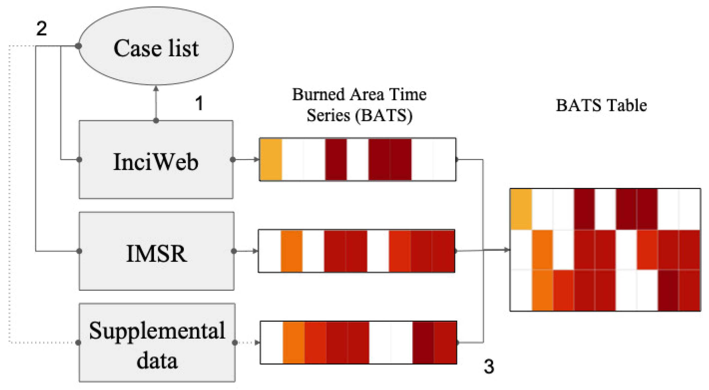
2.1.1. Overview
2.1.2. InciWeb Case List
2.1.3. Construction of BATS
2.1.4. Example
2.2. Dataset Analyses
2.2.1. Overview
2.2.2. External Comparison
2.2.3. Internal Comparison
2.2.4. Application
3. Results
3.1. External Comparison
3.2. Internal Comparison
3.3. Application
4. Discussion
4.1. Advantages and Limitations
4.2. Future Research
5. Conclusions
Author Contributions
Funding
Data Availability Statement
Acknowledgments
Conflicts of Interest
References
- Birch, D.S.; Morgan, P.; Kolden, C.A.; Hudak, A.T.; Smith, A.M. Is proportion burned severely related to daily area burned? Environ. Res. Lett. 2014, 9, 064011. [Google Scholar] [CrossRef]
- Hantson, S.; Andela, N.; Goulden, M.L.; Randerson, J.T. Human-ignited fires result in more extreme fire behavior and ecosystem impacts. Nat. Commun. 2022, 13, 1–8. [Google Scholar] [CrossRef] [PubMed]
- Johansen, M.P.; Hakonson, T.E.; Breshears, D.D. Post-fire runoff and erosion from rainfall simulation: Contrasting forests with shrublands and grasslands. Hydrol. Process. 2001, 15, 2953–2965. [Google Scholar] [CrossRef]
- Wilder, B.A.; Lancaster, J.T.; Cafferata, P.H.; Coe, D.B.; Swanson, B.J.; Lindsay, D.N.; Short, W.R.; Kinoshita, A.M. An analytical solution for rapidly predicting post-fire peak streamflow for small watersheds in southern California. Hydrol. Process. 2021, 35, e13976. [Google Scholar] [CrossRef]
- Stefanidis, S.; Alexandridis, V.; Spalevic, V.; Mincato, R.L. Wildfire effects on soil erosion dynamics: The case of 2021 megafires in Greece. Agric. For. I Sumar. 2022, 68, 49–63. [Google Scholar]
- Stephens, S.L.; Burrows, N.; Buyantuyev, A.; Gray, R.W.; Keane, R.E.; Kubian, R.; Liu, S.; Seijo, F.; Shu, L.; Tolhurst, K.G.; et al. Temperate and boreal forest mega-fires: Characteristics and challenges. Front. Ecol. Environ. 2014, 12, 115–122. [Google Scholar] [CrossRef]
- Page, W.G.; Freeborn, P.H.; Butler, B.W.; Jolly, W.M. A review of US wildland firefighter entrapments: Trends, important environmental factors and research needs. Int. J. Wildland Fire 2019, 28, 551–569. [Google Scholar] [CrossRef]
- Moeltner, K.; Kim, M.K.; Zhu, E.; Yang, W. Wildfire smoke and health impacts: A closer look at fire attributes and their marginal effects. J. Environ. Econ. Manag. 2013, 66, 476–496. [Google Scholar] [CrossRef]
- Noble, J.C. Behaviour of a very fast grassland wildfire on the Riverine Plain of southeastern Australia. Int. J. Wildland Fire 1991, 1, 189–196. [Google Scholar] [CrossRef]
- O’hara, K.C.; Ranches, J.; Roche, L.M.; Schohr, T.K.; Busch, R.C.; Maier, G.U. Impacts from Wildfires on Livestock Health and Production: Producer Perspectives. Animals 2021, 11, 3230. [Google Scholar] [CrossRef]
- Finney, M.; Grenfell, I.C.; McHugh, C.W. Modeling containment of large wildfires using generalized linear mixed-model analysis. For. Sci. 2009, 55, 249–255. [Google Scholar]
- Doerr, S.H.; Santín, C. Global trends in wildfire and its impacts: Perceptions versus realities in a changing world. Philos. Trans. R. Soc. B Biol. Sci. 2016, 371, 20150345. [Google Scholar] [CrossRef] [PubMed] [Green Version]
- Cliff, E.; Price, J.; Lindh, C.; Mays, L.; Cochran, H. The Rattlesnake Fire; USDA Forest Service: Washington, DC, USA, 1953; Available online: http://wlfalwaysremember.org/images/incidents/documents/1953-07-09-rattlesnake-report.pdf (accessed on 4 April 2019).
- Trelles, J.; Pagni, P.J. Fire-induced winds in the 20 October 1991 Oakland Hills fire. Fire Saf. Sci. 1997, 5, 911–922. [Google Scholar] [CrossRef]
- Viegas, D.; Simeoni, A. Eruptive behaviour of forest fires. Fire Technol. 2011, 47, 303–320. [Google Scholar] [CrossRef]
- Keller, E.A.; Valentine, D.W.; Gibbs, D.R. Hydrological response of small watersheds following the Southern California Painted Cave Fire of June 1990. Hydrol. Process. 1997, 11, 401–414. [Google Scholar] [CrossRef]
- Brown, D.K.; Echelle, A.A.; Propst, D.L.; Brooks, J.E.; Fisher, W.L. Catastrophic wildfire and number of populations as factors influencing risk of extinction for Gila trout (Oncorhynchus gilae). West. N. Am. Nat. 2001, 61, 139–148. [Google Scholar]
- Recher, H.F. Impact of wildfire on the avifauna of Kings Park, Perth, Western Australia. Wildl. Res. 1997, 24, 745–761. [Google Scholar] [CrossRef]
- Finney, M.A. Modeling the spread and behavior of prescribed natural fires. In Proceedings of the International Conference on Fire and Forest Meteorology, Jekyll Island, GA, USA, 26–28 October 1993; Volume 13, pp. 8–143. [Google Scholar]
- Billmire, M.; French, N.H.; Loboda, T.; Owen, R.C.; Tyner, M. Santa Ana winds and predictors of wildfire progression in southern California. Int. J. Wildland Fire 2014, 23, 1119–1129. [Google Scholar] [CrossRef]
- Potter, B.E.; McEvoy, D. Weather Factors Associated with Extremely Large Fires and Fire Growth Days. Earth Interact. 2021, 25, 160–176. [Google Scholar] [CrossRef]
- Potter, B.E.; McEvoy, D. Fire Growth and Associated Weather Data for Selected Fires of Unusual Size (FOUS) and Other Fires from 2004 to 2018; Forest Service Research Data Archive: Fort Collins, CO, USA, 2022. [Google Scholar] [CrossRef]
- Abell, C.A. Rates of Initial Spread of Free-Burning Fires on the National Forests of California; Research Note PSW-RN-24; US Department of Agriculture, Forest Service, California Forest and Range Experiment Station: Berkeley, CA, USA, 1940; 27p. [Google Scholar]
- Anderson, H.E. Predicting Wind-Driven Wind Land Fire Size and Shape; US Department of Agriculture, Forest Service, Intermountain Forest and Range: Ogden, UT, USA, 1983; Volume 305. [Google Scholar]
- Taylor, S.W.; Woolford, D.G.; Dean, C.; Martell, D.L. Wildfire prediction to inform fire management: Statistical science challenges. Stat. Sci. 2013, 28, 586–615. [Google Scholar] [CrossRef]
- Eidenshink, J.; Schwind, B.; Brewer, K.; Zhu, Z.L.; Quayle, B.; Howard, S. A project for monitoring trends in burn severity. Fire Ecol. 2007, 3, 3–21. [Google Scholar] [CrossRef]
- Alexander, M.; Thomas, D. Wildland fire behavior case studies and analyses: Other examples, methods, reporting standards, and some practical advice. Fire Manag. Today 2003, 63, 4–12. [Google Scholar]
- St Denis, L.A.; Mietkiewicz, N.P.; Short, K.C.; Buckland, M.; Balch, J.K. All-hazards dataset mined from the US National Incident Management System 1999–2014. Sci. Data 2020, 7, 1–18. [Google Scholar] [CrossRef] [PubMed] [Green Version]
- National Interagency Fire Center. ICS-209 Program (NIMS) User’s Guide. Online; 2020. Available online: https://www.predictiveservices.nifc.gov/intelligence/ICS-209_User_Guide_4.0_2020.pdf (accessed on 1 April 2022).
- Reading the Situation Report. Online; 2018. Available online: https://www.predictiveservices.nifc.gov/intelligence/Reading_the_Situation_Report_2018.pdf (accessed on 1 April 2022).
- Veraverbeke, S.; Sedano, F.; Hook, S.J.; Randerson, J.T.; Jin, Y.; Rogers, B.M. Mapping the daily progression of large wildland fires using MODIS active fire data. Int. J. Wildland Fire 2014, 23, 655–667. [Google Scholar] [CrossRef]
- Podschwit, H.; Guttorp, P.; Larkin, N.; Steel, E.A. Estimating wildfire growth from noisy and incomplete incident data using a state space model. Environ. Ecol. Stat. 2018, 25, 325–340. [Google Scholar] [CrossRef]
- Gemitzi, A.; Koutsias, N. A Google Earth Engine code to estimate properties of vegetation phenology in fire affected areas–A case study in North Evia wildfire event on August 2021. Remote Sens. Appl. Soc. Environ. 2022, 26, 100720. [Google Scholar] [CrossRef]
- Artés, T.; Oom, D.; De Rigo, D.; Durrant, T.H.; Maianti, P.; Libertà, G.; San-Miguel-Ayanz, J. A global wildfire dataset for the analysis of fire regimes and fire behaviour. Sci. Data 2019, 6, 1–11. [Google Scholar] [CrossRef]
- Kolden, C.A.; Weisberg, P.J. Assessing accuracy of manually-mapped wildfire perimeters in topographically dissected areas. Fire Ecol. 2007, 3, 22–31. [Google Scholar] [CrossRef]
- Donovan, G.H.; Prestemon, J.P.; Gebert, K. The effect of newspaper coverage and political pressure on wildfire suppression costs. Soc. Nat. Resour. 2011, 24, 785–798. [Google Scholar] [CrossRef]
- Callister, K.E.; Griffioen, P.A.; Avitabile, S.C.; Haslem, A.; Kelly, L.T.; Kenny, S.A.; Nimmo, D.G.; Farnsworth, L.M.; Taylor, R.S.; Watson, S.J.; et al. Historical maps from modern images: Using remote sensing to model and map century-long vegetation change in a fire-prone region. PLoS ONE 2016, 11, e0150808. [Google Scholar] [CrossRef]
- De Longueville, B.; Smith, R.S.; Luraschi, G. “OMG, from here, I can see the flames!” a use case of mining location based social networks to acquire spatio-temporal data on forest fires. In Proceedings of the 2009 International Workshop on Location Based Social Networks, Seattle, WA, USA, 3 November 2009; pp. 73–80. [Google Scholar]
- Van den Broeck, J.; Argeseanu Cunningham, S.; Eeckels, R.; Herbst, K. Data cleaning: Detecting, diagnosing, and editing data abnormalities. PLoS Med. 2005, 2, e267. [Google Scholar] [CrossRef] [PubMed]
- Sana, M.; Weinreb, A.A. Insiders, outsiders, and the editing of inconsistent survey data. Sociol. Methods Res. 2008, 36, 515–541. [Google Scholar] [CrossRef]
- R: A Language and Environment for Statistical Computing; R Core Team: Vienna, Austria, 2013. Available online: https://www.gbif.org/tool/81287/r-a-language-and-environment-for-statistical-computing (accessed on 1 April 2022).
- Cruz, M.G.; Alexander, M.E. Uncertainty associated with model predictions of surface and crown fire rates of spread. Environ. Model. Softw. 2013, 47, 16–28. [Google Scholar] [CrossRef]
- Strand, T.M.; Larkin, N.; Craig, K.J.; Raffuse, S.; Sullivan, D.; Solomon, R.; Rorig, M.; Wheeler, N.; Pryden, D. Analyses of BlueSky Gateway PM2. 5 predictions during the 2007 southern and 2008 northern California fires. J. Geophys. Res. Atmos. 2012, 117, 1–14. [Google Scholar] [CrossRef]


| Access date | Ignition Date | Latitude | Longitude | Hectares | URL |
|---|---|---|---|---|---|
| 15 October 19 | 10 October 19 | 34.326 | −118.481 | 3396 | http://inciweb.nwcg.gov/incident/6643/ |
| 16 October 19 | 10 October 19 | 34.326 | −118.481 | 3396 | http://inciweb.nwcg.gov/incident/6643/ |
| 17 October 19 | 10 October 19 | 34.326 | −118.481 | 3396 | http://inciweb.nwcg.gov/incident/6643/ |
| 18 October 19 | 10 October 19 | 34.326 | −118.481 | 3561 | http://inciweb.nwcg.gov/incident/6643/ |
| 19 October 19 | 10 October 19 | 34.326 | −118.481 | 3561 | http://inciweb.nwcg.gov/incident/6643/ |
| 20 October 19 | 10 October 19 | 34.326 | −118.481 | 3561 | http://inciweb.nwcg.gov/incident/6643/ |
| 21 October 19 | 10 October 19 | 34.326 | −118.481 | 3561 | http://inciweb.nwcg.gov/incident/6643/ |
| 22 October 19 | 10 October 19 | 34.326 | −118.481 | 3561 | http://inciweb.nwcg.gov/incident/6643/ |
| 23 October 19 | 10 October 19 | 34.326 | −118.481 | 3561 | http://inciweb.nwcg.gov/incident/6643/ |
| 24 October 19 | 10 October 19 | 34.326 | −118.481 | 3561 | http://inciweb.nwcg.gov/incident/6643/ |
| 25 October 19 | 10 October 19 | 34.326 | −118.481 | 3561 | http://inciweb.nwcg.gov/incident/6643/ |
| 26 October 19 | 10 October 19 | 34.326 | −118.481 | 3561 | http://inciweb.nwcg.gov/incident/6643/ |
| 27 October 19 | 10 October 19 | 34.326 | −118.481 | 3561 | http://inciweb.nwcg.gov/incident/6643/ |
| 28 October 19 | 10 October 19 | 34.326 | −118.481 | 3561 | http://inciweb.nwcg.gov/incident/6643/ |
| 29 October 19 | 10 October 19 | 34.326 | −118.481 | 3561 | http://inciweb.nwcg.gov/incident/6643/ |
| 30 October 19 | 10 October 19 | 34.326 | −118.481 | 3561 | http://inciweb.nwcg.gov/incident/6643/ |
| Date | Minimum Size (Pacific Standard Time) | Maximum Size (Pacific Standard Time) |
|---|---|---|
| 10 October 19 | 24 (22:55) | |
| 11 October 19 | 647 (00:19) | 3052 (17:00) |
| 12 October 19 | 3056 (10:45) | 3223 (19:00) |
| 13 October 19 | 3223 (8:00) | 3223 (18:00) |
| 14 October 19 | 3223 (7:00) | 3396 (21:00) |
| 15 October 19 | 3396 (7:00) | 3396 (21:00) |
| 16 October 19 | 3396 (9:00) | 3396 (19:00) |
| 17 October 19 | 3396 (7:00) | 3396 (19:00) |
| 18 October 19 | 3396 (7:00) | 3561 (19:00) |
| 19 October 19 | 3561 (19:00) | 3561 (19:00) |
| 20 October 19 | 3561 (19:00) | 3561 (19:00) |
| 21 October 19 | ||
| 22 October 19 | 3561 (17:00) | 3561 (17:00) |
| WoMBATS | MTBS | |||||
|---|---|---|---|---|---|---|
| Region | State | 2018 | 2019 | 2020 | 2018–2020 | 1984–2016 |
| Western CONUS | California | 27 (27) | 16 (16) | 41 (41) | 84 (84) | 1431 |
| Arizona | 18 (18) | 21 (20) | 42 (42) | 81 (80) | 618 | |
| Nevada | 24 (24) | 9 (9) | 19 (19) | 52 (52) | 819 | |
| New Mexico | 11 (11) | 18 (17) | 10 (10) | 39 (38) | 649 | |
| Colorado | 21 (21) | 4 (4) | 9 (9) | 34 (34) | 245 | |
| Oregon * | 19(19) | 5 (5) | 18 (18) | 42 (42) | 640 | |
| Idaho | 18 (18) | 4 (4) | 12 (12) | 34 (34) | 1243 | |
| Montana | 14 (14) | 6 (6) | 14 (14) | 34 (34) | 617 | |
| Utah | 13 (13) | 6 (6) | 4 (4) | 23 (23) | 554 | |
| Washington | 14 (13) | 3 (3) | 14 (14) | 31 (30) | 418 | |
| Wyoming | 4 (4) | 2 (2) | 5 (4) | 11 (10) | 309 | |
| Eastern CONUS | Texas | 5 (5) | 2 (2) | 26 (26) | 33 (33) | 802 |
| Florida | 3 (3) | 0 (0) | 0 (0) | 3 (3) | 456 | |
| South Carolina | 0 (0) | 1 (1) | 0 (0) | 1 (1) | 30 | |
| West Virginia | 0 (0) | 1 (1) | 0 (0) | 1 (1) | 185 | |
| Oklahoma | 0 (0) | 0 (0) | 0 (0) | 0 (0) | 390 | |
| South Dakota | 0 (0) | 0 (0) | 2 (2) | 2 (2) | 177 | |
| Minnesota | 0 (0) | 0 (0) | 0 (0) | 0 (0) | 170 | |
| Kansas | 0 (0) | 0 (0) | 0 (0) | 0 (0) | 109 | |
| Kentucky | 0 (0) | 0 (0) | 0 (0) | 0 (0) | 101 | |
| Louisiana | 0 (0) | 0 (0) | 0 (0) | 0 (0) | 83 | |
| North Carolina | 0 (0) | 0 (0) | 0 (0) | 0 (0) | 74 | |
| Nebraska | 0 (0) | 0 (0) | 0 (0) | 0 (0) | 73 | |
| Georgia | 0 (0) | 0 (0) | 0 (0) | 0 (0) | 61 | |
| Tennessee | 0 (0) | 0 (0) | 0 (0) | 0 (0) | 54 | |
| North Dakota | 0 (0) | 0 (0) | 0 (0) | 0 (0) | 46 | |
| Virginia | 0 (0) | 0 (0) | 0 (0) | 0 (0) | 45 | |
| Mississippi | 0 (0) | 0 (0) | 0 (0) | 0 (0) | 44 | |
| Arkansas | 0 (0) | 0 (0) | 0 (0) | 0 (0) | 43 | |
| Alabama | 0 (0) | 0 (0) | 0 (0) | 0 (0) | 41 | |
| Missouri | 0 (0) | 0 (0) | 0 (0) | 0 (0) | 41 | |
| Michigan | 0 (0) | 0 (0) | 0 (0) | 0 (0) | 22 | |
| New Jersey | 0 (0) | 0 (0) | 0 (0) | 0 (0) | 18 | |
| Maryland | 0 (0) | 0 (0) | 0 (0) | 0 (0) | 9 | |
| New York | 0 (0) | 0 (0) | 0 (0) | 0 (0) | 6 | |
| Pennsylvania | 0 (0) | 0 (0) | 0 (0) | 0 (0) | 4 | |
| Wisconsin | 0 (0) | 0 (0) | 0 (0) | 0 (0) | 3 | |
| Indiana | 0 (0) | 0 (0) | 0 (0) | 0 (0) | 2 | |
| Ohio | 0 (0) | 0 (0) | 0 (0) | 0 (0) | 2 | |
| Delaware | 0 (0) | 0 (0) | 0 (0) | 0 (0) | 1 | |
| Iowa | 0 (0) | 0 (0) | 0 (0) | 0 (0) | 1 | |
| Maine | 0 (0) | 0 (0) | 0 (0) | 0 (0) | 1 | |
| Outside CONUS | Alaska | 0 (0) | 7 (7) | 1 (1) | 8 (8) | 984 |
| Hawaii | 1 (1) | 0 (0) | 0 (0) | 1 (1) | 17 | |
| Total | 192 (191) | 105 (103) | 217 (216) | 514 (510) | 11,757 |
Publisher’s Note: MDPI stays neutral with regard to jurisdictional claims in published maps and institutional affiliations. |
© 2022 by the authors. Licensee MDPI, Basel, Switzerland. This article is an open access article distributed under the terms and conditions of the Creative Commons Attribution (CC BY) license (https://creativecommons.org/licenses/by/4.0/).
Share and Cite
Podschwit, H.R.; Potter, B.; Larkin, N.K. A Protocol for Collecting Burned Area Time Series Cross-Check Data. Fire 2022, 5, 153. https://doi.org/10.3390/fire5050153
Podschwit HR, Potter B, Larkin NK. A Protocol for Collecting Burned Area Time Series Cross-Check Data. Fire. 2022; 5(5):153. https://doi.org/10.3390/fire5050153
Chicago/Turabian StylePodschwit, Harry R., Brian Potter, and Narasimhan K. Larkin. 2022. "A Protocol for Collecting Burned Area Time Series Cross-Check Data" Fire 5, no. 5: 153. https://doi.org/10.3390/fire5050153
APA StylePodschwit, H. R., Potter, B., & Larkin, N. K. (2022). A Protocol for Collecting Burned Area Time Series Cross-Check Data. Fire, 5(5), 153. https://doi.org/10.3390/fire5050153