Article

Low-Severity Wildfire Shifts Mixed Conifer Forests toward Historical Stand Structure in Guadalupe Mountains National Park, Texas, USA

1
Department of Biology, Regis University, Denver, CO 80221, USA
2
Department of Earth and Environmental Sciences, College of the Environment, Wesleyan University, Middletown, CT 06457, USA
3
Southwest Texas Fire Group, National Park Service, Artesia, NM 88210, USA
4
Department of Biology, Sul Ross State University, Alpine, TX 79832, USA
5
Grand Canyon National Park, National Park Service, Grand Canyon, AZ 86023, USA
6
Department of Geography, Pennsylvania State University, University Park, PA 16802, USA
*
Authors to whom correspondence should be addressed.
Fire 2022, 5(4), 119; https://doi.org/10.3390/fire5040119
Submission received: 8 July 2022 / Revised: 3 August 2022 / Accepted: 7 August 2022 / Published: 18 August 2022

Abstract

:
Wildfire is an important natural disturbance agent, shaping mixed conifer forest structure throughout the Southwestern United States. Yet, fire exclusion caused by late 19th century livestock grazing followed by human fire suppression has altered forest structure by increasing forest density, basal area, and canopy cover in recent decades. Changes in the abundance and vertical and horizontal continuity of fuels have increased the potential for high-severity fire, which construes a major regional forest management concern. In May 2016, the Coyote Fire burned through a network of permanent forest monitoring plots in Guadalupe Mountains National Park. This study employed a repeated-measures sampling design to quantify the effects of low- to moderate-severity wildfire on forest stand structure, species composition, fuels, and tree mortality using hierarchical cluster analysis, non-metric multidimensional scaling (nMDS), and paired t-tests. The 2016 Coyote Fire reduced live tree density in small-diameter size classes, but produced minimal changes in canopy stand structure and fuel loadings, despite nearly a century of fire exclusion and pre-fire tree densities that were four-times higher they were prior to last major wildfire in the early 1900s. Small-diameter surface fuel loadings (1 h and 10 h fuels) did not significantly change after fire, although 1000 h fuels increased significantly (p < 0.05), likely from the addition of new fuel from fire-caused tree mortality. While the wildfire reduced live tree density, the nMDS analysis indicated that the wildfire did not trigger major shifts in tree species composition. However, the wildfire triggered significant decreases in seedlings and small-diameter trees (<30 cm DBH) (p < 0.05). Although the fire thinned the forest, the persistence of fuels and increases in dead small-diameter trees heighten the need for additional fuel reduction treatments to mitigate the risk of future high-severity fire under extreme fire weather. Management of low-severity fire in this forest type may provide opportunities to reduce fuels and restore more desirable stand structure to enhance forest resilience to landscape fire.

1. Introduction

In many fire-prone forests in the Western United States, the size, frequency, and severity of wildfires have increased since the mid-1980s [1,2]. This recent uptick in wildfire activity is triggered by a suite of factors including a century of fuel accumulation from fire exclusion, increased aridity from a warming climate, and a surge in human-caused fire ignitions [3,4]. The ponderosa pine (Pinus ponderosa) and mixed conifer forests in the Southwestern United States historically experienced frequent, low-severity surface fire for centuries. However, in the late 19th and early 20th century, fire frequency declined due to intense livestock grazing and then subsequent organized fire suppression. Exclusion of fire-caused widespread fuel accumulation and altered the horizontal and vertical continuity of fuels, which produced forest stand structures that are now vulnerable to large-canopy killing fires that were historically unusual [5,6,7,8,9].
Through the exclusion of fire, some forest types that historically experienced high-frequency, low-severity fires now exhibit stand structures that differ dramatically from their historic range of variability throughout the region [10,11,12]. In many instances, forests that were historically characterized by high-frequency, low-severity fire regimes are now susceptible to high-severity fire due to fuel accumulation and high forest density has increased vulnerability to drought-induced mortality (especially in conifers), with high-severity fire leading to type conversion at some sites [13,14]. A potential transition to a new high-severity fire regime or an altered vegetation type has stimulated extensive debate about the response and resilience of forests to wildfire in a warmer and fiery future [15,16].
The majority of wildfire effect studies evaluate how recent moderate-severity or high-severity wildfires have impacted forest stand dynamics and fuel loadings [17,18,19,20,21]. However, while high-severity wildfire is increasingly impacting forests in the Western US, some recent wildfires have continued to burn at low or moderate severity in the contemporary era, even in stands that have experienced decades to a century of fire suppression [22]. In these locations, post-fire conifer regeneration is abundant and large-diameter trees survive in the canopy after wildfire. Relatively few studies have evaluated the effects of recent low-severity fires in fire-suppressed forests (but see [23,24]). Moreover, there is a paucity of research on contemporary low-severity wildfire effects on mixed conifer forests, especially in warm-dry mixed conifer forests in the southwest, where historic fire regimes were similarly characterized by low-severity fire [12,25,26]. Understanding of low-severity wildfire effects is especially important in the context of wildland fire use as a management tool because fire severity is a major influence on the severity of subsequent wildfires and prescribed burns [27,28].
The mixed conifer forests in the southern Guadalupe Mountains of Texas historically experienced a high-frequency, low-severity fire regime, with spatially extensive fires burning the high country of the mountains every 9–15 years [8,29]. The last major fire occurred in the park in 1922 and then goat and sheep grazing and organized fire suppression effectively excluded fire from the landscape and triggered an increase in tree density and basal area, a shift in species composition towards shade-tolerant species and, presumably, higher-surface fuels [8].
Here, we quantify changes in forest stand structure, surface fuels, and tree species composition in response to a low-severity wildfire that burned through the warm, dry mixed conifer forests of Guadalupe Mountains National Park, Texas, after 94 years of fire exclusion. Two years after the fire, we resurveyed a network of 97 permanent plots that were originally installed in 2003 and 2010 to quantify stand structure and fuels to address the following research questions: (1) How does stand structure and species composition change in response to low-severity fire, (2) how do recent fire-induced structural changes compare to reconstructions of stand structure prior to fire exclusion, and (3) does fuel type and quantity change with low-severity wildfire? We hypothesized that after nearly a century of fire exclusion, this low-severity fire would: (1) reduce live and dead tree densities across a range of diameter classes, from small to large, (2) reduce surface fuels, litter and duff depth, (3) trigger a compositional shift from understory woody species, such as Douglas fir (Pseudotsuga menziesii (Mirb.) Franco) and Gambel oak (Quercus gambelii Nutt.), that had recruited since the onset of fire exclusion towards canopy species that were dominant before fire exclusion (e.g., ponderosa pine and southwestern white pine (Pinus strobiformis)), and (4) a high proportion of small-diameter trees would be killed by the wildfire.

2. Materials and Methods
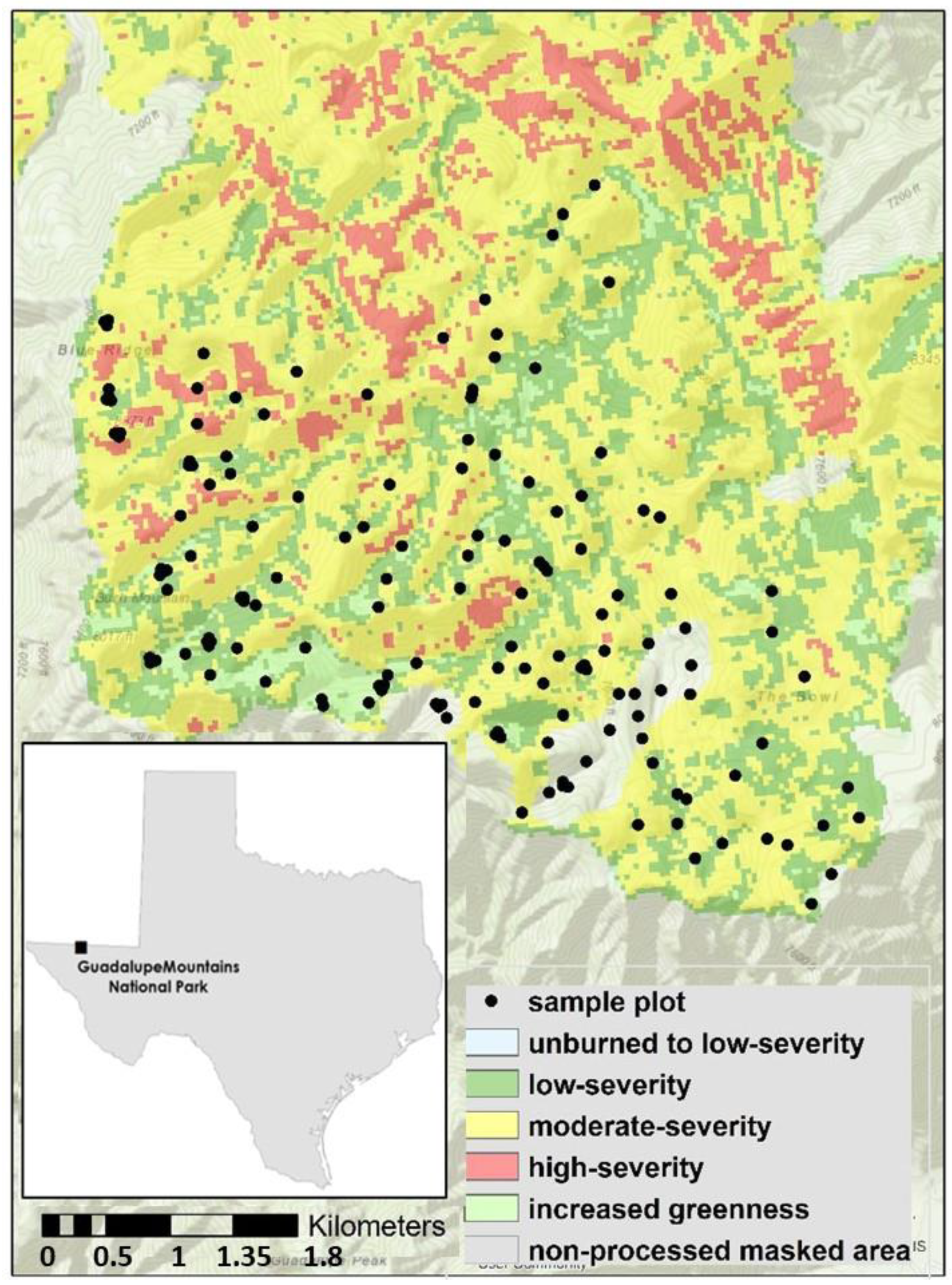
2.1. Study Area

The Guadalupe Mountains extend approximately 80 km across southeastern New Mexico and west Texas in a northeast to southwest orientation. Guadalupe Mountains National Park (GUMO) is located at the southern tip of the range in Culberson County, Texas (Figure 1). The southern portion of the mountains are the remnants of a Permian limestone reef that was uplifted 900 m above the surrounding Chihuahuan Desert and now forms a large plateau with rolling ridges and valleys. Soils are mostly shallow and well-drained sandy loams [30]. No perennial water courses are located on the plateau because intermittent streams disappear into limestone caverns within the reef.
Mixed conifer forests occupy the highest portions of the range at elevations between 2200 and 2700 m. Vegetation in the mixed conifer zone varies by slope position and slope aspect [8]. Cooler, moister sites on north-facing slopes and valley bottoms are dominated by southwestern white pine (Pinus strobiformis Engelm.) and Douglas Fir, while stands on drier sites at ridgetops and other slope aspects are composed of ponderosa pine (Pinus ponderosa Douglas ex C. Lawson), alligator juniper (Juniperus deppeana Steud.), Gambel oak, and Colorado pinyon pine (Pinus edulis Engelm.). The driest sites on upper slopes with southerly aspects are not forested but contain vegetation comprised by grasses, shrubs, and succulents.
The climate is semi-arid with cool winters and hot summers. Mean January minimum temperature at nearby Carlsbad Caverns is 0.8 °C and mean July maximum temperature is 32.7 °C. Mean annual precipitation at nearby Carlsbad Caverns is 37.5 cm, with the majority falling between May and October during the summer monsoon. Ignitions from lightning typically peak in mid to late spring before the onset of monsoon precipitation [29].
Humans have occupied the Guadalupe Mountains and surrounding region for at least 10,000 years [31]. The most recent indigenous population to occupy the region was the Mescalero Apache, who inhabited the area until United States troops forced them out around 1870. Euro-American settlement followed shortly after the subjugation and removal of the Apache, and livestock grazing in the high country began in the early 1920s after installation of a permanent water source. Extensive grazing of sheep and goats at high elevations continued until the establishment of Guadalupe Mountains National Park in 1972.
Prior to Euro-American settlement, mixed conifer forests in the Guadalupe Mountains experienced frequent fire with a mean fire return interval of 16.3 years for fires that burned large areas on the plateau [8]. Most fires also occurred early in the growing season or late in the dormant season before the onset of spring growth. A widespread fire in the mixed conifer forest occurred in 1922 according to tree-ring fire-scar records, shortly after the onset of livestock grazing. Several fires burned through portions of the range outside our plot network including the 1990 Frijole Fire, the 1993 Pine Fire, and the 2010 Cutoff Fire; however, the forest within our plot network had remained unburned prior to the Coyote Fire since the onset of fire suppression in 1922 [8]. The 94-year period of fire exclusion was likely caused by the elimination of fine fuels by grazing, followed by organized direct fire suppression after the establishment of the national park. Fire exclusion led to a three-fold increase in tree density and basal area, as well as a compositional shift in tree dominance from southwestern white pine to Douglas fir.

2.2. The Coyote Fire

A lightning strike ignited the Coyote Fire on 7 May 2016 in the northwest portion of GUMO near Coyote Peak. Over two months, the fire spread southeast, burning most of the mixed conifer zone in the park. Although fuel loads were high in the burn area, the fire largely burned as a low- to moderate-severity surface fire (Figure 1). Drought conditions and fuel moisture during the Coyote Fire were average for the site: Palmer Drought Severity Index (PDSI) was −1.03 (i.e., mild drought) for April 2016 and −0.85 (i.e., incipient drought) for May 2016 (Figure S1). April 2016 was the 65th driest April and May 2016 was the 67th driest May out of 125 years of observations (National Climatic Data Center, n.d.). During the fire, 1000 h fuel moisture ranged from 10–14%, which was slightly above the 1985–2019 mean (Figure S2). Similarly, the burning index during the fire was close to the 1985–2019 mean. The fire burned through two independent networks of forest and fuels plots that were established before the fire. Sakulich and Taylor [8] collected stand structure and composition data in 0.04 ha fixed area plots in 2003 and 2004. Poulos also collected stand structure and composition data in addition to surface fuel data in 0.03 ha fixed area plots in 2010. The plot networks were distributed throughout the mixed conifer zone in the park and spanned a range of forested topographic settings (Figure 1).

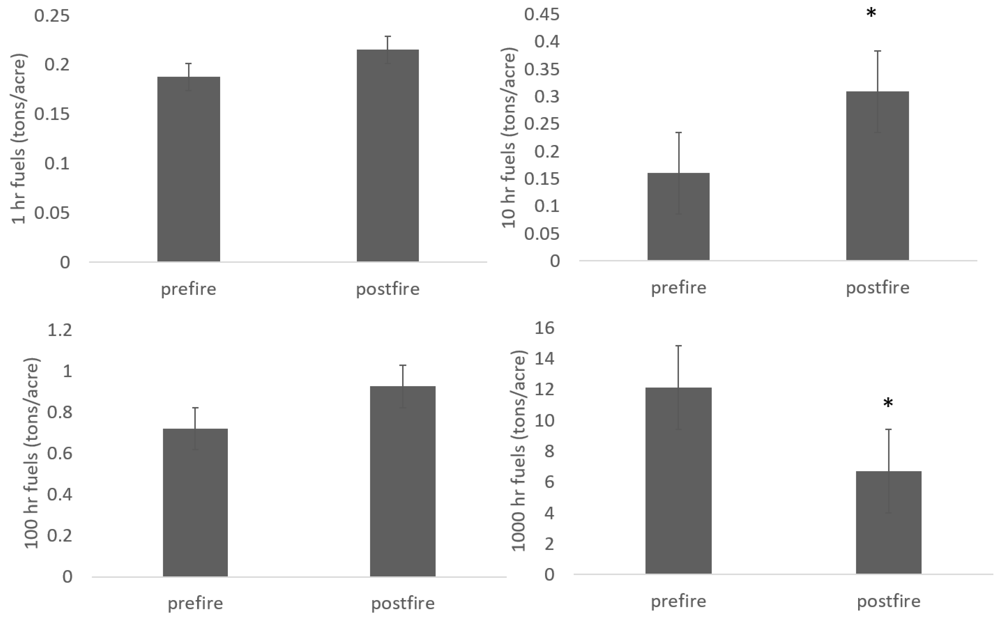
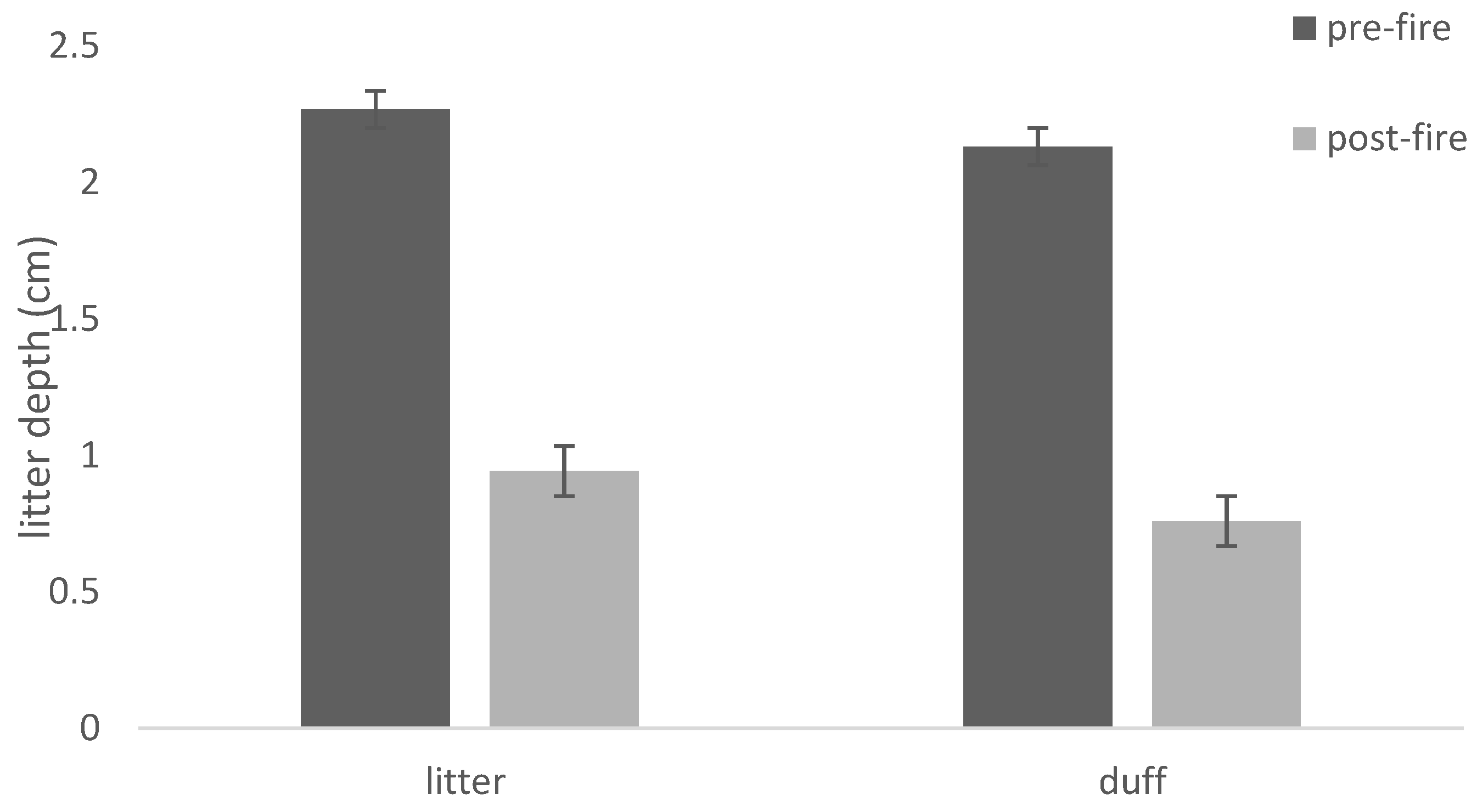
2.3. Stand Structure and Fuels Plots

To quantify changes in stand structure and fuel loadings in response to the 2016 Coyote Fire, we resampled 97 plots of the Poulos–Sakulich plot network over the summer and winter of 2017 and 2018 (Figure 1). In both sets of sample plots (n = 40 from the Poulos network and n = 57 from the Sakulich network), we used the original study sampling protocols by recording the density and distribution of seedlings (<5 cm diameter at breast height (DBH)) and trees (>5 cm DBH) as well as fuel loadings (in the Poulos plots only). In both sampling intervals, we recorded the species, dbh, live crown height, total height (and live crown ratio), and crown class of each tree. Seedlings (0–5 cm DBH) were tallied by species in nested 5 m radius circular plots in the Poulos plots and throughout the entire 0.04 ha Sakulich plots. Dead and down fuel loads were estimated at a random azimuth from each plot using line intercept sampling following standard fuel inventory methods from Brown [32]. The azimuth of each pre-fire fuel inventory line was repeated to minimize fuel load sampling errors in the post-fire fuel inventory time step.
Tree basal area (m2 ha–1), as well as tree and seedling density (ha–1) were calculated by plot and by species in each plot. We calculated species importance values for each plot as the sum of the relative density and the relative basal area (BA) of each species (0–200 range) to identify the dominant tree species cover types for both the pre- and post-fire sampling intervals. Trees were also tallied in 5 cm size classes to evaluate changes in forest stand structure since the initial sampling date.
All statistical analyses were performed using the R Statistical Language [33]. Differences in forest structure and composition between the pre- and post-fire plot sampling intervals were evaluated using paired t-tests. We tested for differences between the pre- versus post-fire plant community for the following parameters by species and by plot: seedling and tree density, density in 5-cm size-classes, basal area, and surface fuel loadings. Our decision to analyze these data using paired t-tests rather than employing linear mixed effects models to evaluate change over time with fire severity as an interaction factor was based on the fact that our plots experienced little variation in fire severity. We justified this analysis because 90% of the wildfire burned at low- to moderate-severity according to the differenced normalized burn ratio data (dNBR)for the Coyote Fire from MTBS (with a differenced normalized burn ratio range of 0–388), with no sample plots burning at high fire severity at our sample plots within the Coyote Fire perimeter.

2.4. Stand Structure Reconstruction

To compare pre- and post-fire stand structure to the pre-fire exclusion period, we reconstructed stand conditions present at the time of the last major wildfire in 1922. In the original collection of plot data by Sakulich [8], dead trees were classified into categories of wood decay based on methods prescribed by Thomas [34] and increment cores were collected from a sample of live trees within each plot. Increment cores were processed using standard techniques [35] and annual rings were visually cross dated to determine dates of tree establishment. Reconstructions were developed by removing trees with an establishment date after 1922, subtracting diameter increments from trees predating the reconstruction date and adding dead trees that would have been alive at the reconstruction date back into the stand. The lack of stand replacing disturbance as well as the slow rate of wood decay in warm-dry mixed conifer forests allow for a fine-scale reconstruction of past forest conditions based on dead trees present in the stand. The year of death for each dead tree was estimated using methods developed by Covington, Fule, Moore, Hart, Kolb, Mast, Sackett and Wagner [11]. The decay condition of each dead tree was used to predict its death date using a tree decay model [36]. Dead trees added back into the reconstructed stand had annual diameter increments removed based on average growth increments for each species (i.e., diameter growth from 1922 to date of death). Density and basal area for reconstructed stands were quantified and compared to contemporary (pre- and post-fire) stand structure.

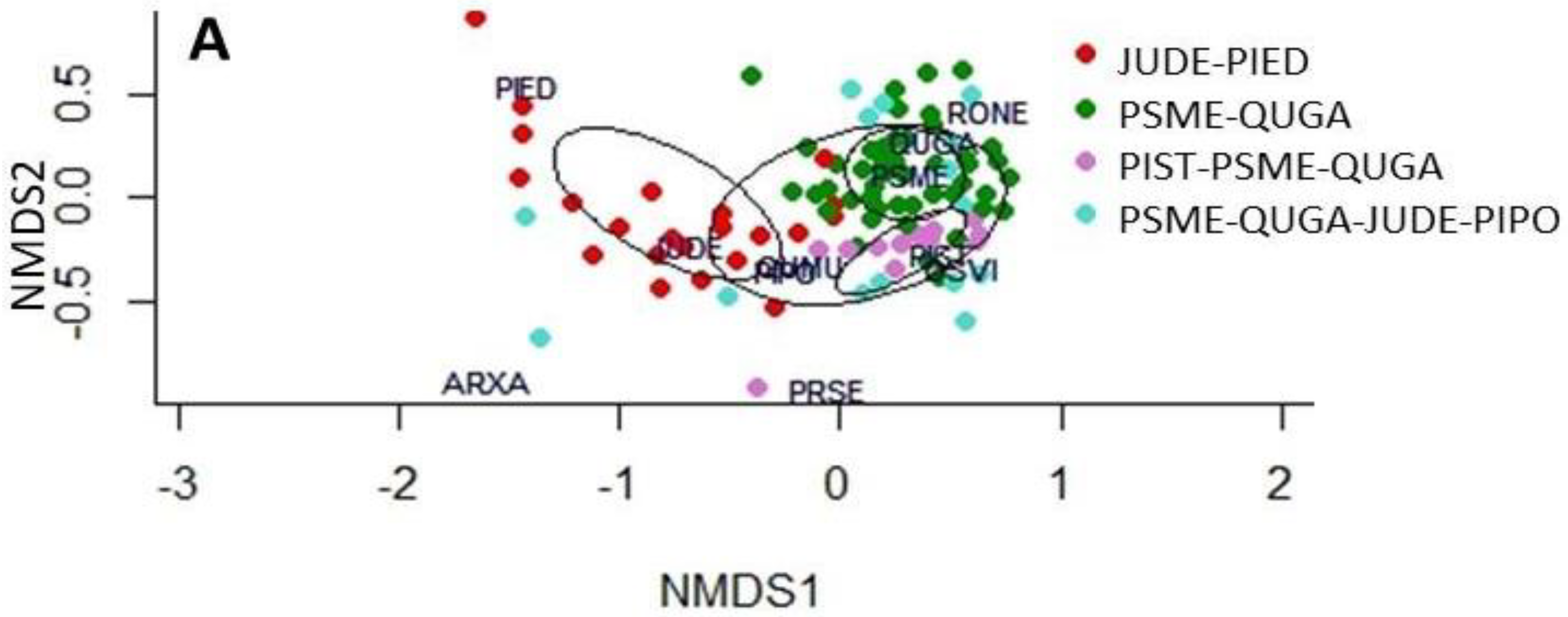
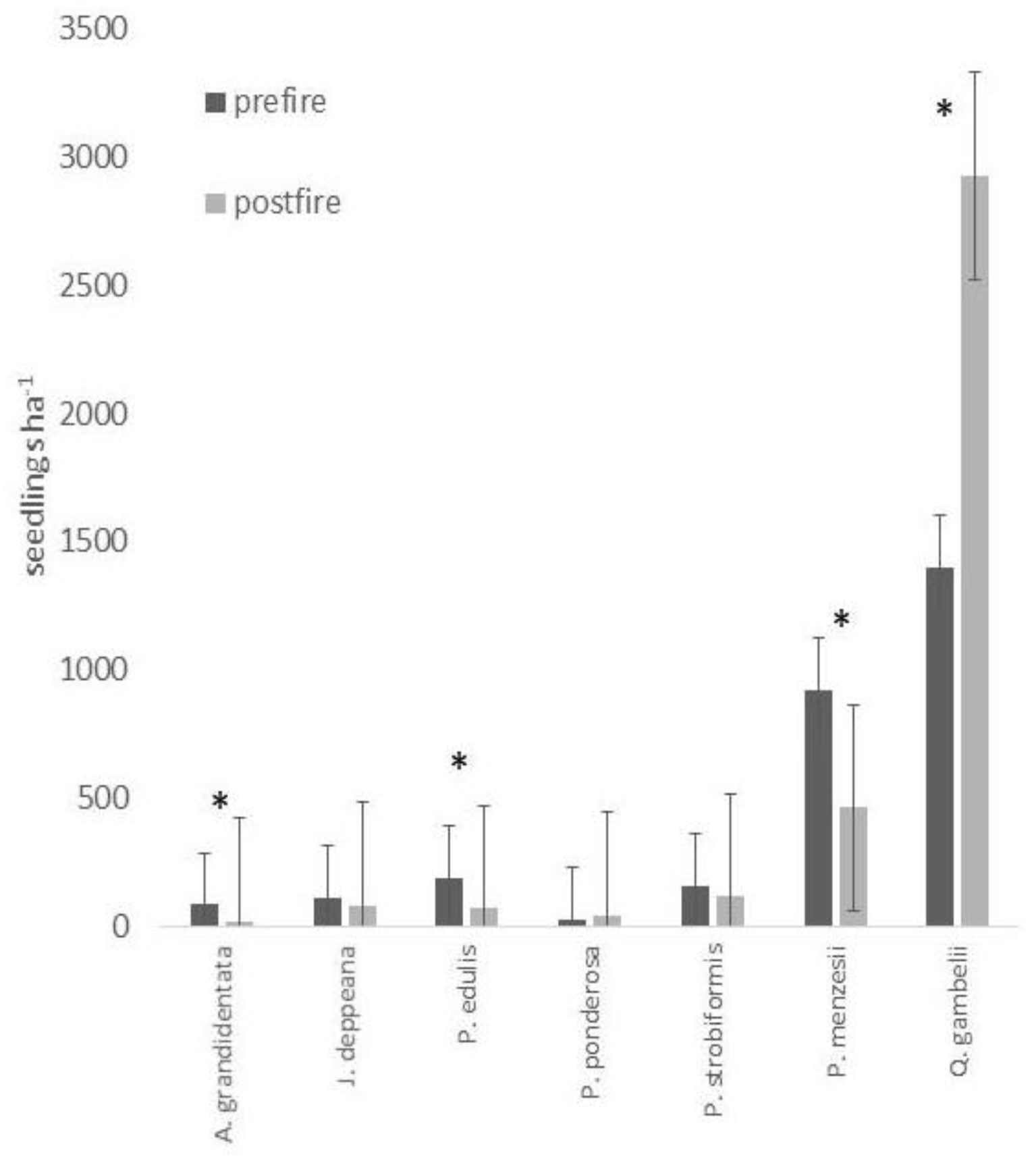
2.5. Changes in Stand Composition
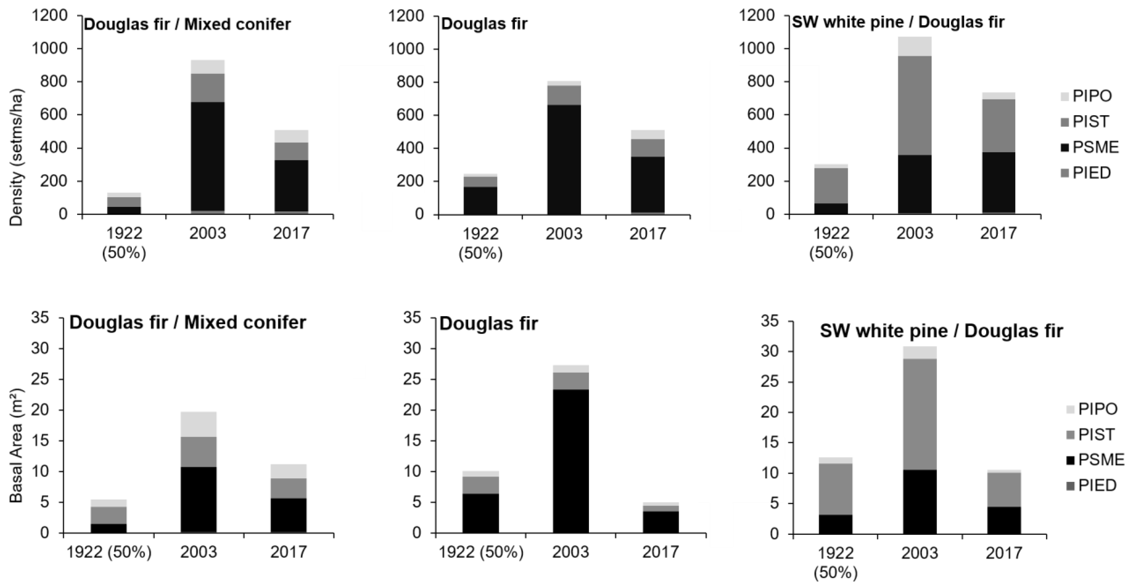
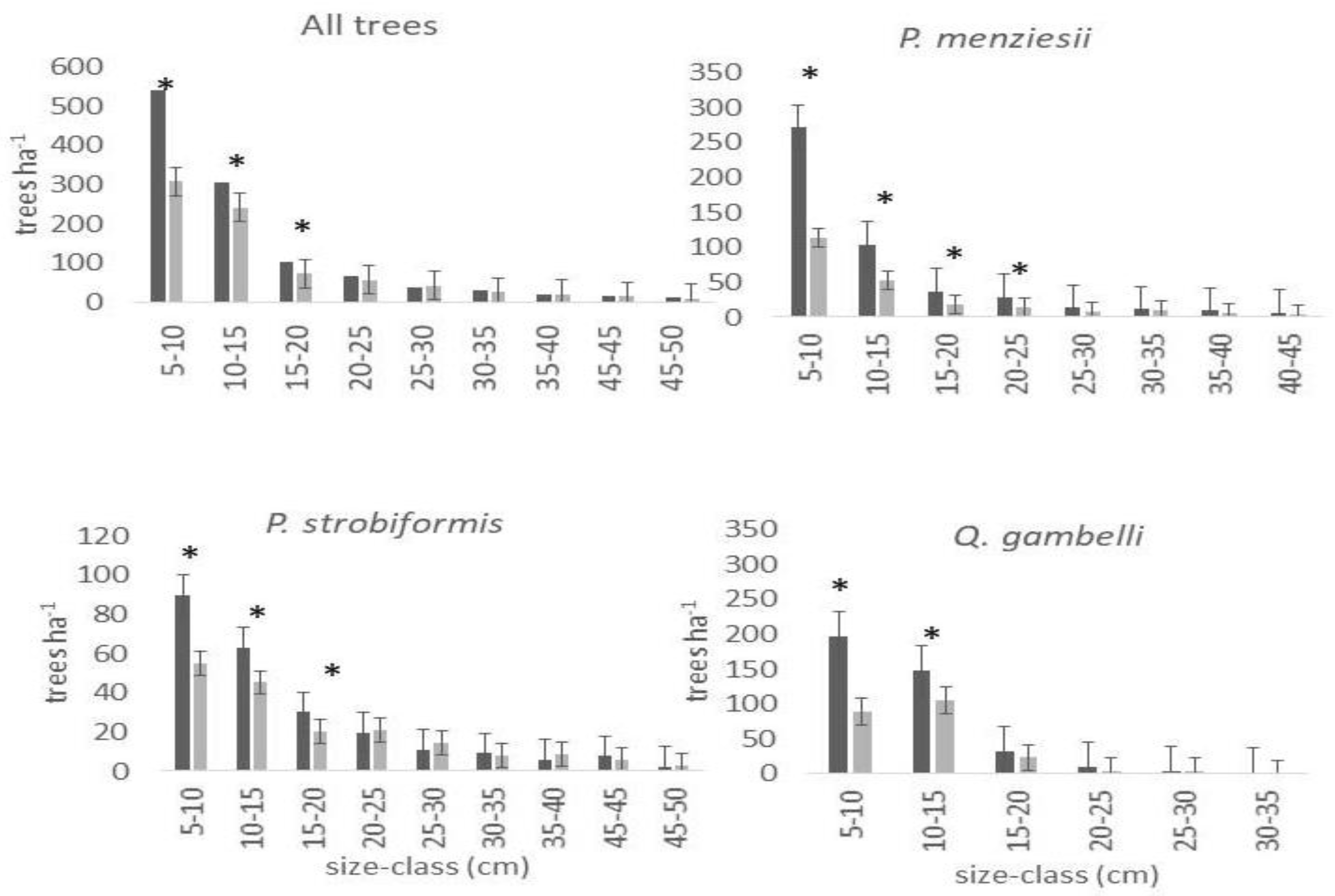
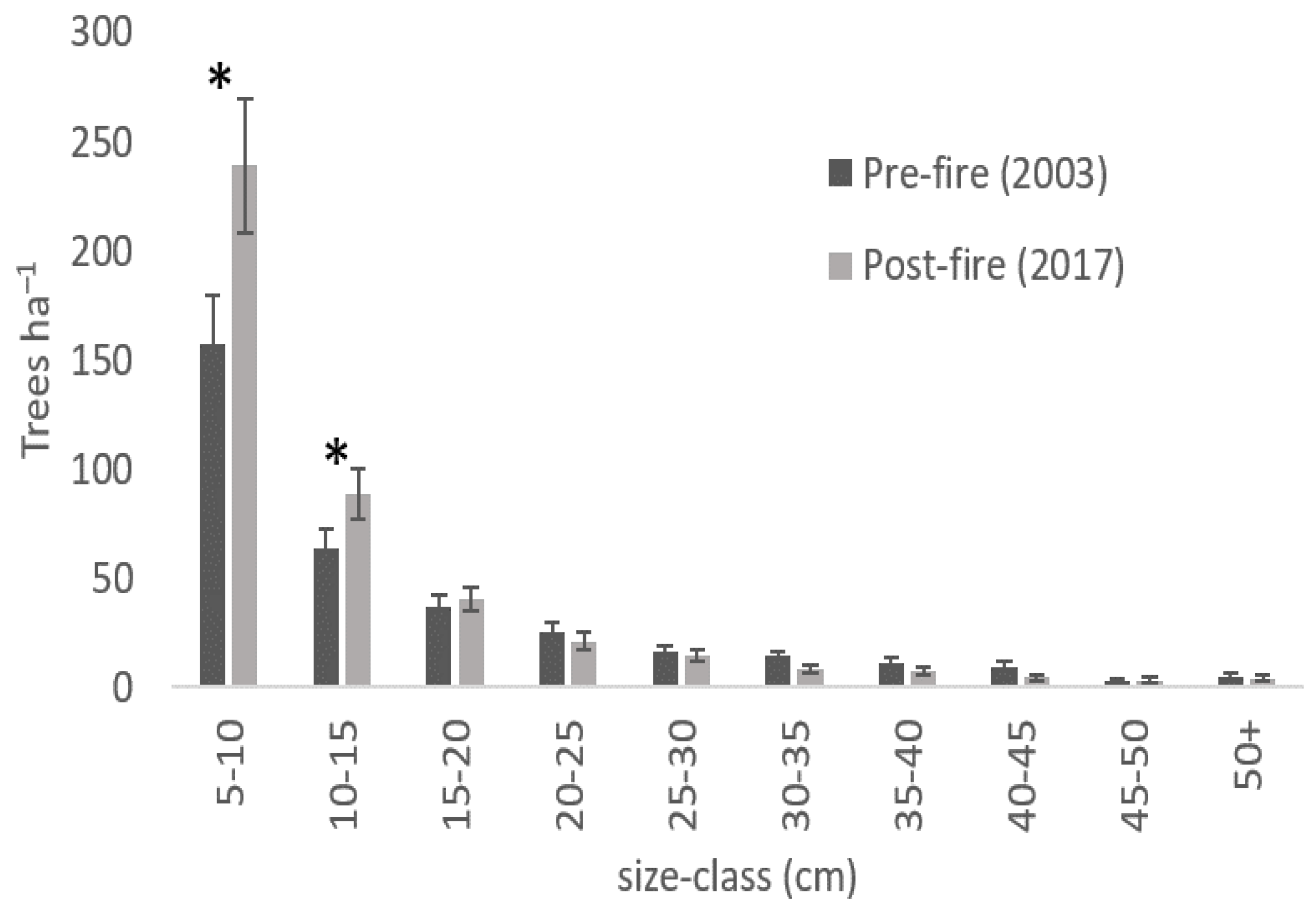
We employed hierarchical cluster analysis and non-metric multidimensional scaling (nMDS) to determine environmental and fire severity influences on stand composition and to investigate changes in species composition pre- and post-fire. We used cluster analysis on the importance values of all species in pre-fire plots to identify groups of plots with similar dominant species prior to the wildfire. Clustering was performed by via the hclust function and the NbClust package in Charrad et al. [37] using Euclidean distances and Ward’s method. Then, we used nMDS to analyze community-level vegetation changes. The nMDS analyses were conducted using the vegan package in Ref. [38]. To assess changes in species importance before and after the Coyote Fire, we analyzed the species importance values for the 97 sample plots from both periods (pre-fire and post-fire) and displayed plots in species space by vegetation type (i.e., cluster group). Shifts in species composition between the pre- and post-fire time-series were evaluated by plotting vectors that link the mean position of pre-fire and post-fire plot vegetation types in nMDS species space. Finally, we evaluated the influence of fire severity and other environmental variables on post-fire species composition using only the 2018 data. For all of these analyses, we examined (1) the loadings of individual species along axes to reveal patterns in community variation and (2) the statistical relationships of field-measured and raster-derived environmental variables with the nMDS axes to explore possible environmental drivers of such variation.

3. Results

Four dominant vegetation types were identified via the cluster analysis, including: (1) forest dominated by alligator juniper and pinyon pine (JUDE-PIED), (2) Douglas fir-Gambel oak forest (PSME-QUGA), (3) Southwestern white pine-Douglas fir-Gambel oak forest (PIST-PSME-QUGA), and (4) Douglas fir-Gambel oak-alligator juniper-ponderosa pine forest (PSME-mixed conifer). The distribution of vegetation types was associated with slope aspect and slope position; PIED-JUDE stands were typically located on west and south aspect slopes and on ridgetops, while more mesic vegetation types (PSME-QUGA and PIST-PSME-QUGA) occupied north-facing slopes and valley bottoms. Tree density and basal area increased approximately four-fold during the 94-year period of fire exclusion (Figure 2). Reconstructed live tree density for 1922 was below 300 trees ha–1 in the PSME-mixed conifer, PSME-QUGA, and PIST-PSME-QUGA vegetation types. The increase in density from the onset of fire exclusion to prior to the wildfire was driven by a large increase in Douglas fir in the PSME-mixed conifer and PSME-QUGA vegetation types and by recruitment of southwestern white pine in the PIST-PSME-QUGA vegetation type. After the Coyote Fire, density decreased across the three reconstructed vegetation types, but live tree density remained much higher than in 1922. The pattern of change in the basal area mirrored the changes in tree density. The small amount of change in tree density and basal area between reconstructions with different decay rates indicates that reconstructions are not sensitive to variable rates of decay relative to changes pre- and post-fire (Figure 2).
Trees in the smallest size-classes (<20 cm DBH) declined significantly in abundance over the sampling interval, while the density of large-diameter trees remained unchanged (Figure 3). Among the dominant tree species in the study area, Douglas fir experienced significant decreases in tree density for trees <30 cm DBH, southwestern white pines experienced significant mortality in size classes <20 cm DBHs, and Gambel oak displayed significant decreases in tree density for trees <15 cm DBH. Total tree density and basal area declined significantly after fire, but the magnitude of decline varied among species (Table 1).
Total seedling density increased (t = 2.6086, p = 0.01051) from an average of 3009 ± 348.7 S.E. pre fire to 5024 ± 819.6 S.E. trees per ha after fire, but this is the result of a large increase in Gambel oak, which re-sprouts from the root collar in response to fire. Douglas fir and pinyon pine seedlings significantly decreased following fire, while southwestern white pine seedlings decreased slightly (Figure 4).
Small-diameter (<15-cm dbh) dead tree densities increased after fire (Figure 5); dead trees in the smallest diameter class (5–10-cm) increased from an average of 157 stems ha–1 to 239 stems ha–1 and dead trees 10–15-cm dbh increased from 64 to 89 stems ha–1. We found no significant differences in the density of dead trees for diameter classes greater than 15 cm DBH. Additionally, we identified 64% of dead trees as fire killed (i.e., red needles present on the tree and fresh char on the bark).
Fuel loadings of 10 h fuels increased significantly from 336.2 kg/ha pre fire to 672.5 kg/ha post fire (Figure 6). Fuel loading for 1000 h fuels also decreased significantly after fire from 26.9 Mg/ha to 13.5 Mg/ha. However, fine fuels (i.e., 1 h and 100 h fuels) and total fuel loadings were similar before and after the fire. Depth of litter and duff layers declined after fire (Figure 7), whereby the depth of the litter layer in fuel inventory plots decreased from an average of 2.38 cm pre fire to 0.94 cm post fire and duff depth declined from an average of 2.24 cm to 0.76 cm.
Stand composition did not change significantly in the study area between the pre-fire and post-fire periods and fire severity was not a significant driver of plant community compositional change according to the nMDS results (Figure 8). Overall, plots overlapped in species space with the exception of the most xeric vegetation group (JUDE-PIED), which tended to separate from other plots along axis 1 (Figure 8A). The final nMDS produced a two-dimensional solution, with a final stress of 0.16. The ordination results indicated that there was no significant shift in the species space of plots between the pre- and post-fire sampling intervals when the nMDS was plotted with 95% confidence ellipses among the two time-steps (Figure 8B, Table 2). Elevation and incident solar radiation were the two significant factors influencing plot species dominance in both the pre-fire and post-fire ordinations, highlighting that fire severity (i.e., dNBR) was not a significant influence on the species space of the post-fire plant community (Figure 8C), likely due to the small range in variation of dNBR among sample plots. While changes in species space were not significant and plots did not experience shifts between vegetation groups, the four vegetation types experienced some post-fire changes in the same species that experienced changes in forest stand structure, including Douglas fir, pinyon pine, southwestern white pine, and Gambel oak (Figure 8D).

4. Discussion

Despite high fuel loadings driven by increases in tree density and surface fuel accumulation over nearly a century of fire exclusion, the 2016 Coyote Fire burned largely as a low-severity surface fire where fire-induced tree mortality was concentrated in seedlings and small-diameter trees. Furthermore, fuel loadings for most size classes remained unchanged after wildfire. While 1000 h fuels decreased after fire, only 10 h fuels increased significantly. This pattern may be explained by the pattern of fire-induced tree mortality based on our observations of many small-diameter trees and seedlings with charred bark that appeared to be fire killed (i.e., red needles still attached to twigs). These small trees were likely killed by the fire but not consumed by it, thus, adding surface fuels to the landscape. The minimal change or increase in 1, 10, and 100 h fuels suggests that the addition of fuels through tree mortality offset or exceeded fuel consumption by the fire. Overall, the pattern of surface fuels post wildfire resembles that of a first-entry prescribed fire. A future reduction in fuels will require additional prescribed fire or low-severity wildfire.
Although the fire did not reduce fuels, live tree density in small-diameter classes declined substantially. Live tree density increased over the fire-exclusion period (1922–2003) from approximately 200 trees ha–1 to nearly 900 trees ha–1. The increases in density and basal area were mostly caused by the establishment of vast numbers of small (5–10 cm dbh) Douglas fir and southwestern white pine in the understory. In an analysis of restoration treatments in mixed conifer forests in southwestern Colorado, Stoddard et al. (2015) found live tree density reductions of 35% after burn-only treatments. Similarly, we observed a 36–44% reduction in tree density when comparing pre- and post-fire live tree density. Although, the Coyote Fire reduced tree density and basal area, the tree density and basal area remains higher than the pre-fire exclusion period. Reconstruction was possible only in the PSME-mixed conifer, PSME-QUGA, and PIST-PSME-QUGA vegetation types because reliable age data could not be obtained from cores of alligator juniper, a major component of the PIED-JUDE type, which likely also experienced similar changes in forest stand structure over the study period.
In general, we found higher fire-induced mortality in shade-tolerant understory species compared to managed wildfire and prescribed fire studies in warm-dry mixed conifer forests of the San Juan Mountains [39] and Grand Canyon National Park [40]. In both of these studies, the main understory species established in the absence of fire were white fir and Douglas fir. In Grand Canyon National Park, in particular, first-entry burns were considered insufficient to produce white fir mortality in accordance with management objectives [40]. However, in our study, the major understory species were Douglas fir and southwestern white pine. Additionally, the onset of effective fire exclusion through livestock grazing at Guadalupe Mountains National Park was 40 years later than other sites in the southwest. The combination of different understory species composition and younger understory trees may account for higher rates of fire-induced mortality at these sites compared to ours. Such differences in fire effects among different mixed conifer sites highlight the importance of considering the importance of spatial variation in wildfire effects when making forest management decisions.
Because fire-induced stand structural dynamics were manifest primarily by reductions in the abundances of small, understory trees in response to low-severity fire, species compositional shifts were minor. However, some important patterns emerged within vegetation types. For example, alligator juniper experienced little fire-induced tree mortality and they increased in importance over time in JUDE-PIED and PIST-PSME-QUGA stands, while remaining unchanged in the other two vegetation types. Such a response is likely tied to their moderate fire resistance and ability to re-sprout vigorously from the root crown after wildfire [41,42]. Similarly, ponderosa pine, a fire-resistant species, increased in importance value in JUDE-PIED and PIST-PSME-QUGA stands and stayed the same in PSME-QUGA and PSME-mixed conifer stands. Douglas fir decreased in importance in all four vegetation types and southwestern white pine decreased in importance in three of four types (Table 2). Taken together, this indicates a minor shift from fire-sensitive species (Douglas fir and southwestern white pine, especially when small) to fire-resistant species (alligator juniper and ponderosa pine), through the process of fire-induced mortality of small trees.
The results presented herein provide insight into low-severity fire effects in a warm-dry mixed conifer forest in the Southwest. Few prior studies have specifically quantified the effects of low-severity wildfire on forest conditions in the region (but see [23,24]). This paper, therefore, provides some of the only information on recent low-severity wildfire effects on forest stand dynamics in the Southwest, although there is literature on the effects of low-severity prescribed fire on vegetation [43]. Additionally, the species composition, stand structure, ecological dynamics, and fire regimes in warm-dry mixed conifer forests are highly variable and distinct from the cool-moist mixed conifer forests of the Rocky Mountains and Pacific Northwest. Despite the importance of fire in warm-dry mixed conifer forests, relatively few studies have examined fire regimes in this forest type (but see [12,44,45]) and existing studies have emphasized variability in fire regimes and effects across mixed conifer sites [46]. Quantifying variability in fire effects across distinct mixed conifer sites is, therefore, important for informing forest management priorities in these forests.
Much of the recent literature has quantified the effects of the recent spate of mixed- [17,19,20,47,48] and high-severity wildfire [13,18,49,50,51,52] on forest stand structure and community composition in this region. However, relatively little literature has focused on the effects of recent low-severity wildfire. Our results demonstrate that, under average fire weather and fuel moisture, contemporary managed wildfires in mixed conifer forests can continue to burn at low severity, even after nearly a century of fire exclusion and extensive tree recruitment in the absence of fire. Moreover, these low-severity fires can have effects that align with management objectives, such as restoring low-density stand structure.
The Coyote Fire was an example of an effectively managed wildfire where some important restoration goals were accomplished. NPS personnel conducted back burns on many ridgetops to avert high-severity fire in areas where convection would preheat fuels upslope and lead to higher fire intensity. Additionally, the prevailing weather and fuel moisture conditions during the fire were close to long-term averages for the region. Management and fire weather conditions resulted in significant decreases in small (<20 cm dbh) live trees, decreases in coarse woody debris (1000 h fuels), and decreases in the depth of litter and duff layers. The fire killed few large canopy trees and compositional changes in the canopy were minimal. However, fire-induced mortality of understory trees led to an increase in fine fuels (significant increase in 10 h fuels and slight increases in 1 h fuels).
Previous research in other dry, fire-prone forests in the West have emphasized the need for multiple burns and/or thinning and burning treatments to achieve the management goals of fuel reduction or restoration to pre-fire exclusion forest structure [39,40,53,54]. Fuel treatments, such as prescribed fire, have often been effective for mitigations in severe fire in fuel-dominated fire regimes where fire exclusion has led to anomalously high fuel loads [55]. Management strategies that include reducing tree densities and surface fuels, as well as retaining drought-tolerant and fire-tolerant species, may also increase the resilience of forests to future drought and disturbance related to climate change [53]. While the Coyote fire reduced live tree density and basal area to levels similar to pre-fire exclusion conditions, fuels remain anomalously high in much of the landscape because of fire-induced mortality of small trees. If fuel reduction is a major management objective in Guadalupe Mountains National Park, additional prescribed fire or managed wildfire may be a potential management tool for avoiding future high-severity wildfire under extreme fire weather conditions, as a mechanism for maintaining large-diameter trees in these forests.

Supplementary Materials

The following supporting information can be downloaded at: https://www.mdpi.com/article/10.3390/fire5040119/s1, Figure S1: April (top panel) and May (bottom panel) Palmer Drought Severity Index for Texas climate division 5 (West Texas). Values less than zero indicate drought. The red point symbol indicates 2016. Figure S2: Moisture of 1000 h fuels measured during the Coyote Fire (May 2016).

Author Contributions

J.S., H.M.P., A.H.T., C.M. and R.G.G. conceptualized the study. H.M.P., J.S., A.H.T., R.G.G. and K.A.W. conducted the field work for the study, with J.S. and K.A.W. as lead field scientists. H.M.P. and J.S. performed the analyses and prepared the original draft. All authors have read and agreed to the published version of the manuscript.

Funding

This research was funded by the National Park Service, NPS Grant No. P17AC01115, the Interagency Joint Fire Science Program (01C-3-3-25), NPS Grant TNC-02-GUMO, and the Regis University Research and Scholarship Council.

Institutional Review Board Statement

Not applicable.

Informed Consent Statement

Not applicable.

Data Availability Statement

Data will be made available upon request.

Acknowledgments

We are grateful to staff at Guadalupe Mountains National Park, including Jonena Hearst, Mike Medrano, Fred Armstrong, Jack Kinkaid, and John Montoya. We also thank Leslie Kuhn, Ezra Steinfeld, Cameron Trachsel, and Darren Wallis for assistance in the field.

Conflicts of Interest

The authors declare no conflict of interest. The funders had no role in the design of the study; in the collection, analyses, or interpretation of data; in the writing of the manuscript; or in the decision to publish the results.

References

  1. Westerling, A.L. Increasing western US forest wildfire activity: Sensitivity to changes in the timing of spring. Philos. Trans. R. Soc. B 2016, 371, 20150178. [Google Scholar] [CrossRef] [PubMed]
  2. Westerling, A.L.; Hidalgo, H.G.; Cayan, D.R.; Swetnam, T.W. Warming and earlier spring increase western US forest wildfire activity. Science 2006, 313, 940–943. [Google Scholar] [CrossRef] [PubMed]
  3. Hurteau, M.D.; Bradford, J.B.; Fulé, P.Z.; Taylor, A.H.; Martin, K.L. Climate change, fire management, and ecological services in the southwestern US. For. Ecol. Manag. 2014, 327, 280–289. [Google Scholar] [CrossRef]
  4. Nagy, R.; Fusco, E.; Bradley, B.; Abatzoglou, J.T.; Balch, J. Human-related ignitions increase the number of large wildfires across US ecoregions. Fire 2018, 1, 4. [Google Scholar] [CrossRef]
  5. Covington, W.W.; Moore, M.M. Southwestern Ponderosa Forest Structure—Changes since Euro-American Settlement. J. For. 1994, 92, 39–47. [Google Scholar]
  6. Poulos, H.M.; Villanueva Díaz, J.; Cerano Paredes, J.; Camp, A.E.; Gatewood, R.G. Human influences on fire regimes and forest structure in the Chihuahuan Desert Borderlands. For. Ecol. Manag. 2013, 298, 1–11. [Google Scholar] [CrossRef]
  7. Poulos, H.; Gatewood, R.; Camp, A. Fire regimes of the piñon-juniper woodlands of Big Bend National Park and the Davis Mountains, west Texas, USA. Can. J. For. Res. 2009, 39, 1236–1246. [Google Scholar] [CrossRef]
  8. Sakulich, J.; Taylor, A.H. Fire regimes and forest structure in a sky island mixed conifer forest, Guadalupe Mountains National Park, Texas, USA. For. Ecol. Manag. 2007, 241, 62–73. [Google Scholar] [CrossRef]
  9. Savage, M.; Swetnam, T.W.J.E. Early 19th-century fire decline following sheep pasturing in a Navajo ponderosa pine forest. Ecology 1990, 71, 2374–2378. [Google Scholar] [CrossRef]
  10. Coop, J.D.; Parks, S.A.; McClernan, S.R.; Holsinger, L.M. Influences of prior wildfires on vegetation response to subsequent fire in a reburned southwestern landscape. Ecol. Appl. 2016, 26, 346–354. [Google Scholar] [CrossRef]
  11. Covington, W.W.; Fule, P.Z.; Moore, M.M.; Hart, S.C.; Kolb, T.E.; Mast, J.N.; Sackett, S.S.; Wagner, M.R. Restoring ecosystem health in ponderosa pine forests of the Southwest. J. For. 1997, 95, 23. [Google Scholar]
  12. O’Connor, C.D.; Falk, D.A.; Lynch, A.M.; Swetnam, T.W. Fire severity, size, and climate associations diverge from historical precedent along an ecological gradient in the Pinaleño Mountains, Arizona, USA. For. Ecol. Manag. 2014, 329, 264–278. [Google Scholar] [CrossRef]
  13. Barton, A.M.; Poulos, H.M. Pine vs. oaks revisited: Conversion of Madrean pine-oak forest to oak shrubland after high-severity wildfire in the Sky Islands of Arizona. For. Ecol. Manag. 2018, 414, 28–40. [Google Scholar] [CrossRef]
  14. Stephens, S.L.; Collins, B.M.; Fettig, C.J.; Finney, M.A.; Hoffman, C.M.; Knapp, E.E.; North, M.P.; Safford, H.; Wayman, R.B. Drought, Tree Mortality, and Wildfire in Forests Adapted to Frequent Fire. BioScience 2018, 68, 77–88. [Google Scholar] [CrossRef]
  15. Moritz, M.A.; Batllori, E.; Bradstock, R.A.; Gill, A.M.; Handmer, J.; Hessburg, P.F.; Leonard, J.; McCaffrey, S.; Odion, D.C.; Schoennagel, T. Learning to coexist with wildfire. Nature 2014, 515, 58–66. [Google Scholar] [CrossRef]
  16. Schoennagel, T.; Balch, J.K.; Brenkert-Smith, H.; Dennison, P.E.; Harvey, B.J.; Krawchuk, M.A.; Mietkiewicz, N.; Morgan, P.; Moritz, M.A.; Rasker, R.; et al. Adapt to more wildfire in western North American forests as climate changes. Proc. Natl. Acad. Sci. USA 2017, 114, 4582–4590. [Google Scholar] [CrossRef]
  17. Donato, D.C.; Fontaine, J.B.; Campbell, J.L.; Robinson, W.D.; Kauffman, J.B.; Law, B.E. Conifer regeneration in stand-replacement portions of a large mixed-severity wildfire in the Klamath–Siskiyou Mountains. Can. J. For. Res. 2009, 39, 823–838. [Google Scholar] [CrossRef]
  18. Haffey, C.; Sisk, T.D.; Allen, C.D.; Thode, A.E.; Margolis, E.Q. Limits to Ponderosa Pine Regeneration following Large High-Severity Forest Fires in the United States Southwest. Fire Ecol. 2018, 14, 143–163. [Google Scholar] [CrossRef]
  19. Halofsky, J.; Donato, D.; Hibbs, D.; Campbell, J.; Cannon, M.D.; Fontaine, J.; Thompson, J.R.; Anthony, R.; Bormann, B.; Kayes, L. Mixed-severity fire regimes: Lessons and hypotheses from the Klamath-Siskiyou Ecoregion. Ecosphere 2011, 2, 1–19. [Google Scholar] [CrossRef]
  20. Keyser, T.L.; Lentile, L.B.; Smith, F.W.; Shepperd, W.D. Changes in forest structure after a large, mixed-severity wildfire in ponderosa pine forests of the Black Hills, South Dakota, USA. For. Sci. 2008, 54, 328–338. [Google Scholar]
  21. Lydersen, J.M.; Collins, B.M.; Hunsaker, C.T. Implementation constraints limit benefits of restoration treatments in mixed-conifer forests. Int. J. Wildland Fire 2019, 28, 495–511. [Google Scholar] [CrossRef]
  22. Owen, S.M.; Sieg, C.H.; Meador, A.J.S.; Fulé, P.Z.; Iniguez, J.M.; Baggett, L.S.; Fornwalt, P.J.; Battaglia, M.A. Spatial patterns of ponderosa pine regeneration in high-severity burn patches. For. Ecol. Manag. 2017, 405, 134–149. [Google Scholar] [CrossRef]
  23. Parks, S.A.; Dobrowski, S.Z.; Panunto, M.H. What drives low-severity fire in the Southwestern USA? Forests 2018, 9, 165. [Google Scholar] [CrossRef]
  24. Poulos, H.M.; Reemts, C.M.; Wogan, K.A.; Karges, J.P.; Gatewood, R.G. Multiple wildfires with minimal consequences: Low-severity wildfire effects on West Texas piñon-juniper woodlands. For. Ecol. Manag. 2020, 473, 118293. [Google Scholar] [CrossRef]
  25. Romme, W.H.; Allen, C.D.; Bailey, J.D.; Baker, W.L.; Bestelmeyer, B.T.; Brown, P.M.; Eisenhart, K.S.; Floyd, M.L.; Huffman, D.W.; Jacobs, B.F. Historical and modern disturbance regimes, stand structures, and landscape dynamics in piñon–juniper vegetation of the western United States. Rangel. Ecol. Manag. 2009, 62, 203–222. [Google Scholar] [CrossRef]
  26. Strom, B.A.; Fulé, P.Z. Pre-wildfire fuel treatments affect long-term ponderosa pine forest dynamics. Int. J. Wildland Fire 2007, 16, 128–138. [Google Scholar] [CrossRef]
  27. Coppoletta, M.; Merriam, K.E.; Collins, B.M. Post-fire vegetation and fuel development influences fire severity patterns in reburns. Ecol. Appl. 2016, 26, 686–699. [Google Scholar] [CrossRef]
  28. Harris, L.; Taylor, A.H. Topography, fuels, and fire exclusion drive fire severity of the Rim Fire in an old-growth mixed-conifer forest, Yosemite National Park, USA. Ecosystems 2015, 18, 1192–1208. [Google Scholar] [CrossRef]
  29. Ahlstrand, G.M. Fire History of a Mixed Conifer Forest in Guadalupe Mountains National Park. In Proceedings of the Fire History Workshop, Tucson, Arizona, 20–24 October 1980; p. 4. [Google Scholar]
  30. Kittams, W.H. Effect of fire on vegetation of the Chihuahuan Desert region. In Proceedings of the 13th Tall Timbers Fire Ecology Conference, Tallahassee, FL, USA, 1 December 1973. [Google Scholar]
  31. Fabry, J.K. Guadalupe Mountains National Park: An Administrative History; Division of History, Southwest Cultural Resources Center: Santa Fe, NM, USA, 1990. [Google Scholar]
  32. R Development Core Team. A Language and Environment for Statistical Computing; R Foundation for Statistical Computing: Vienna, Austria, 2021. [Google Scholar]
  33. Thomas, J.W. Wildlife Habitats in Managed Forests: The Blue Mountains of Oregon and Washington; Wildlife Management Institute: Washington, DC, USA, 1979. [Google Scholar]
  34. Speer, J.H. Fundamentals of Tree-Ring Research; University of Arizona Press: Tucson, AZ, USA, 2010. [Google Scholar]
  35. Rogers, J.J. ECOSIM: A System for Projecting Multiresource Outputs under Alternative Forest Management Regimes Administrative Report. 1984. Available online: https://agris.fao.org/agris-search/search.do?recordID=US8919234 (accessed on 8 July 2021).
  36. Charrad, M.; Ghazzali, N.; Boiteau, V.; Niknafs, A.; Charrad, M.M. Package ‘NbClust’. J. Stat. Softw. 2014, 61, 1–36. [Google Scholar]
  37. Oksanen, J.; Blanchet, F.G.; Kindt, R.; Legendre, P.; Minchin, P.R.; O’hara, R.; Simpson, G.L.; Solymos, P.; Stevens, M.H.H.; Wagner, H. Package ‘vegan’. Community Ecol. Packag. Version 2013, 2, 1–295. [Google Scholar]
  38. Stoddard, M.T.; Sánchez Meador, A.J.; Fulé, P.Z.; Korb, J.E. Five-year post-restoration conditions and simulated climate-change trajectories in a warm/dry mixed-conifer forest, southwestern Colorado, USA. For. Ecol. Manag. 2015, 356, 253–261. [Google Scholar] [CrossRef]
  39. Higgins, A.M.; Waring, K.M.; Thode, A.E. The effects of burn entry and burn severity on ponderosa pine and mixed conifer forests in Grand Canyon National Park. Int. J. Wildland Fire 2015, 24, 495–506. [Google Scholar] [CrossRef]
  40. Erdman, J.A. Pinyon-juniper succession after natural fires on residual soils of Mesa Verde, Colorado. Brigh. Young Univ. Sci. Bull. Biol. Ser. 1970, 11, 1. [Google Scholar]
  41. Kaufmann, M.R.; Huisjen, D.W.; Kitchen, S.; Babler, M.; Abella, S.R.; Gardiner, T.S.; McAvoy, D.; Howie, J.; Douglas, H.P. Gambel Oak Ecology and Management in the Southern Rockies: The Status of Our Knowledge; Colorado State University, Southern Rockies Fire Sciences Network: Fort Collins, CO, USA, 2016; 16p. [Google Scholar]
  42. Poulos, H.; Gatewood, R. Effectiveness of Thinning and Prescribed Fire Fuel Treatments in Piñon-Juniper Woodlands of the Davis Mountains, West Texas, USA. J. Sustain. For. 2013, 32, 806–821. [Google Scholar] [CrossRef]
  43. Allen, C.D.; Savage, M.; Falk, D.A.; Suckling, K.F.; Swetnam, T.W.; Schulke, T.; Stacey, P.B.; Morgan, P.; Hoffman, M.; Klingel, J.T. Ecological restoration of southwestern ponderosa pine ecosystems: A broad perspective. Ecol. Appl. 2002, 12, 1418–1433. [Google Scholar] [CrossRef]
  44. Anderson, R.S.; Jass, R.B.; Toney, J.L.; Allen, C.D.; Cisneros-Dozal, L.M.; Hess, M.; Heikoop, J.; Fessenden, J. Development of the mixed conifer forest in northern New Mexico and its relationship to Holocene environmental change. Quat. Res. 2008, 69, 263–275. [Google Scholar] [CrossRef]
  45. Malone, S.L.; Fornwalt, P.J.; Battaglia, M.A.; Chambers, M.E.; Iniguez, J.M.; Sieg, C.H. Mixed-severity fire fosters heterogeneous spatial patterns of conifer regeneration in a dry conifer forest. Forests 2018, 9, 45. [Google Scholar] [CrossRef]
  46. Korb, J.E.; Fornwalt, P.J.; Stevens-Rumann, C.S. What drives ponderosa pine regeneration following wildfire in the western United States? For. Ecol. Manag. 2019, 454, 117663. [Google Scholar] [CrossRef]
  47. Parsons, D.J.; Keane, R.E. Mixed-severity fire regimes in the northern Rocky Mountains: Consequences of fire exclusion and options for the future. In Wilderness Science in a Time of Change Conference: Wilderness Ecosystems, Threats, and Management; US Department of Agriculture, Forest Service, Rocky Mountain Research Station: Fort Collins, CO, USA, 2000; Volume 5. [Google Scholar]
  48. Perry, D.A.; Hessburg, P.F.; Skinner, C.N.; Spies, T.A.; Stephens, S.L.; Taylor, A.H.; Franklin, J.F.; McComb, B.; Riegel, G. The ecology of mixed severity fire regimes in Washington, Oregon, and Northern California. For. Ecol. Manag. 2011, 262, 703–717. [Google Scholar] [CrossRef]
  49. Fulé, P. Effects of an intense wildfire in a Mexican oak-pine forest. For. Sci. 2000, 46, 52–61. [Google Scholar]
  50. Barton, A.M.; Poulos, H. Wildfire and topography drive woody plant diversity in a Sky Island mountain range in the Southwest USA. Ecol. Evol. 2021, 11, 14715–14732. [Google Scholar] [CrossRef]
  51. Poulos, H.M.; Freiburger, M.R.; Barton, A.M.; Taylor, A.H.J.F. Mixed-Severity Wildfire as a Driver of Vegetation Change in an Arizona Madrean Sky Island System, USA. Fire 2021, 4, 78. [Google Scholar] [CrossRef]
  52. Lydersen, J.M.; North, M.P.; Collins, B.M. Severity of an uncharacteristically large wildfire, the Rim Fire, in forests with relatively restored frequent fire regimes. For. Ecol. Manag. 2014, 328, 326–334. [Google Scholar] [CrossRef]
  53. McIver, J.D.; Stephens, S.L.; Agee, J.K.; Barbour, J.; Boerner, R.E.; Edminster, C.B.; Erickson, K.L.; Farris, K.L.; Fettig, C.J.; Fiedler, C.E.J.I.J.o.W.F. Ecological effects of alternative fuel-reduction treatments: Highlights of the National Fire and Fire Surrogate study (FFS). Int. J. Wildland Fire 2012, 22, 63–82. [Google Scholar] [CrossRef]
  54. Stephens, S.L.; Moghaddas, J.J.; Edminster, C.; Fiedler, C.E.; Haase, S.; Harrington, M.; Keeley, J.E.; Knapp, E.E.; McIver, J.D.; Metlen, K. Fire treatment effects on vegetation structure, fuels, and potential fire severity in western US forests. Ecol. Appl. 2009, 19, 305–320. [Google Scholar] [CrossRef]
  55. Addington, R.N.; Aplet, G.H.; Battaglia, M.A.; Briggs, J.S.; Brown, P.M.; Cheng, A.S.; Dickinson, Y.; Feinstein, J.A.; Pelz, K.A.; Regan, C.M.; et al. Principles and Practices for the Restoration of Ponderosa Pine and Dry Mixed-Conifer Forests of the Colorado Front Range; US Department of Agriculture, Forest Service, Rocky Mountain Research Station: Fort Collins, CO, USA, 2018; 121p.
Figure 1. Map of the sample plot network that was sampled to quantify fire effects of the 2016 Coyote Fire in Guadalupe Mountains National Park, Texas. Sample plots are displayed on top of the MTBS (https://www.mtbs.gov/ (accessed on 25 March 2018)) fire severity map of the Coyote Fire.
Fire 05 00119 g001
Figure 2. Tree density (top panels) and basal area (bottom panels) for plots within the PSME (Douglas fir)-mixed conifer, PSME-QUGA (Douglas fir-Gambel oak), and PIST-PSME-QUGA (Southwestern white pine-Douglas fir-Gambel oak) vegetation types. Values for 1922 are reconstructed based on tree age data and using the 50th percentile decay rate. Values for 2003 and 2017 are pre- and post-fire data collected directly from plots.
Fire 05 00119 g002
Figure 3. Mean size-class distributions (# ha−1) in 5-cm size classes for all trees (+1 S.E.) and for tree species that displayed significant changes in forest size structure in response to the Coyote Fire. Asterisks signify significant paired t-tests between the pre- and post-fire sampling interval at p < 0.05 for trees > 5-cm DBH at Guadalupe Mountains National Park.
Fire 05 00119 g003
Figure 4. Mean seedling abundance (# ha−1) by species (+1 S.E.) for the pre- and post-fire sampling intervals in Guadalupe Mountain National Park, Texas. Asterisks signify significant paired t-tests at p < 0.05.
Fire 05 00119 g004
Figure 5. Mean size-class distributions of dead trees (+1 S.E.) measured in stand structure plots for the pre- and post-fire sampling intervals in Guadalupe Mountain National Park, Texas. Asterisks signify significant paired t-tests at p < 0.05.
Fire 05 00119 g005
Figure 6. Mean (+1 S.E) of 1-, 10-, 100-, and 1000 h fuel loadings before and after the Coyote Fire in Guadalupe Mountains National Park, Texas. Significant differences (p < 0.05) over the time-step according to paired t-tests are indicated with asterisks (*).
Fire 05 00119 g006
Figure 7. Mean depth of litter and depth layers (+1 S.E.) measured in fuels plots for the pre- and post-fire sampling intervals.
Fire 05 00119 g007
Figure 8. Non-metric multidimensional (nMDS) scaling results displaying (A) plots in species space for the four dominant vegetation types in Guadalupe Mountains National Park, (B) pre-versus post-fire plots in species space plotted with 95% confidence intervals (red = pre-fire and gray = post-fire), (C) Surface fits of significant (p < 0.05) environmental variables influencing plot species composition, and (D) shifts in species composition by vegetation type over the time-series. Forest composition was significantly associated with elevation (red isopleths) and solar radiation (green isopleths) in panel C but did not experience a significant shift in plant community composition over time or in relation to fire severity (dNBR) according to the nMDS solution. Tree species acronyms are: Acer grandidentata (ACGR), Arbutus xalapensis (ARXA), Juniperus deppeana (JUDE), Quercus gambelli (QUGA), Quercus meuhlebergii (QUMU), Ostrya virginiana (OSVI), (PIED), Prunus serotina (PRSE), Pseudostuga menzeisii (PSME), Pinus ponderosa (PIPO), Pinus strobus (PIST), and Robinia neomexicana (RONE).
Fire 05 00119 g008aFire 05 00119 g008b
Table 1. Means (+1 S.E.) of seedling density, tree density, and basal area for all plots and by species prior to and one year after the Coyote Fire in Guadalupe Mountains National Park, Texas. Significant differences between the pre- and post-fire sampling interval according to paired t-tests are displayed with asterisks (NS = not significant, * = p < 0.05, and ** = p < 0.01).
VariableYearAcer grandidentataJuniperus deppeanaPinus edulisPinus ponderosaPinus strobiformisPseudotsuga menzesiiQuercus gambeliiTotal
tree density (# ha−2)200489.2 ± 36.3*1234.4 ± 200.6ns684.0 ± 180.9*1435.9 ± 247.3ns2748.6 ± 458.4**5289.0 ± 578.1**4129.2 ± 429.8ns16,053.0 ± 200.6**
201823.6 ± 13.01121.7 ± 178.9475.5 ± 134.31045.8 ± 181.52043.0 ± 351.72814.2 ± 340.74959.1 ± 653.412,904.2 ± 178.9
basal area (m2 ha−2)20040.1 ± 0.0ns3.4 ± 0.6ns96.8 ± 0.3ns3.3 ± 0.5ns0.2 ± 1.0ns8.7 ± 0.0ns3.4 ± 1.1**25.9 ± 0.4**
20180.1 ± 0.03.2 ± 0.588.7 ± 0.23.0 ± 0.40.0 ± 0.87.2 ± 0.02.1 ± 0.822.0 ± 0.3
Table 2. Mean species importance values for each time-step in each of the four dominant vegetation types in Guadalupe Mountains National Park. Importance values were calculated as the sum of the relative tree basal area and density for all stems in each plot. JUDE-PIED indicates the alligator juniper-piñon pine vegetation type, PSME-QUGA stands for the Douglas fir-Gambel oak vegetation type, PIST-PSME-QUGA is the southwestern white pine-Douglas fir-Gambel oak type, and PSME-QUGA-JUDE-PIPO indicates the Douglas fir-Gambel oak-alligator juniper-ponderosa pine vegetation type.
SpeciesTime-StepJUDE-PIEDPSME-QUGAPIST-PSME-QUGAPSME-QUGA-JUDE-PIPO
Acer grandidentatapre-fire0.01.30.11.3
post-fire0.01.10.31.0
Arbutus xalapensispre-fire0.70.10.00.0
post-fire1.20.50.00.0
Juniperus deppeanapre-fire42.615.812.033.1
post-fire63.215.532.831.2
Ostrya virginianapre-fire0.30.60.00.6
post-fire0.02.00.00.5
Pinus edulispre-fire40.611.27.517.9
post-fire33.24.91.623.6
Pinus ponderosapre-fire27.022.413.922.9
post-fire39.520.625.820.5
Pinus strobiformispre-fire21.325.562.727.3
post-fire11.134.350.822.6
Prunus serotinapre-fire0.60.20.00.4
post-fire0.20.20.80.9
Pseudotsuga menzeisiipre-fire36.267.454.455.3
post-fire28.664.548.537.9
Quercus gambeliipre-fire30.652.548.237.8
post-fire18.449.438.349.2
Quercus meuhlembergiipre-fire0.01.10.01.4
post-fire4.50.60.61.4
Robinia neomexicanapre-fire0.10.40.40.4
post-fire0.01.00.02.0
Publisher’s Note: MDPI stays neutral with regard to jurisdictional claims in published maps and institutional affiliations.

