
Evaluating the Persistence of Post-Wildfire Ash: A Multi-Platform Spatiotemporal Analysis


Abstract
:1. Introduction
2. Materials and Methods
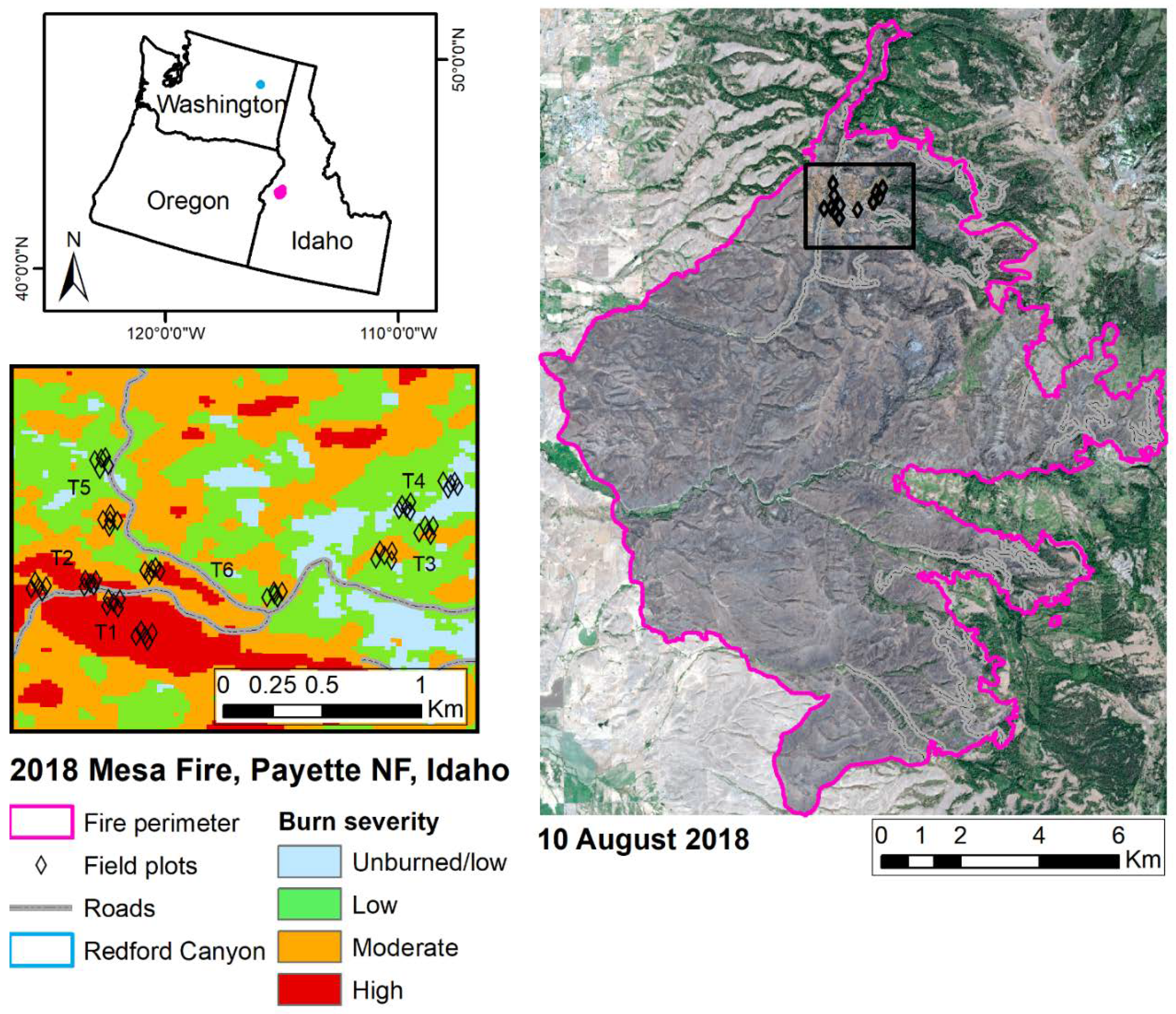
2.1. Site Descriptions
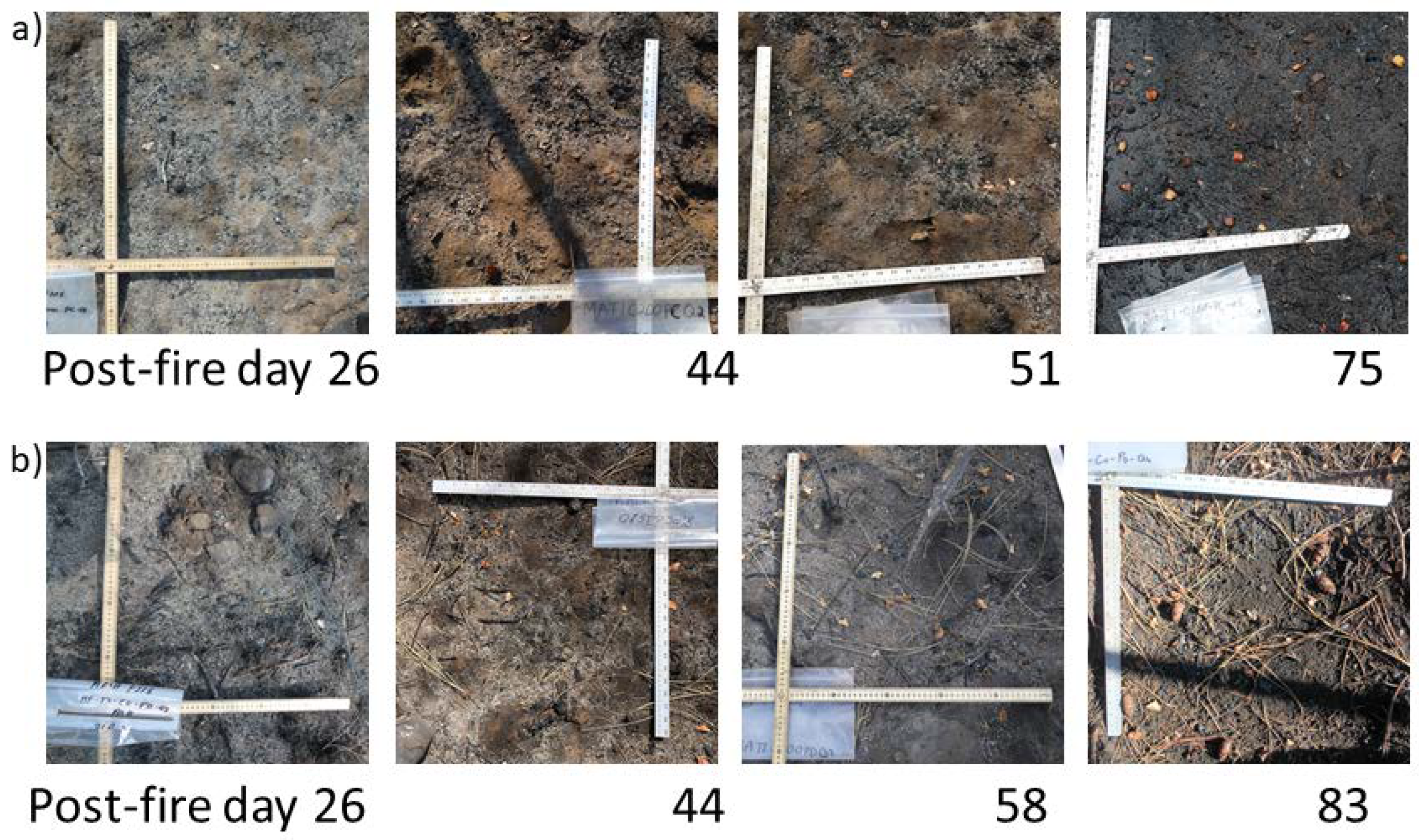
2.2. Field Site Characterization
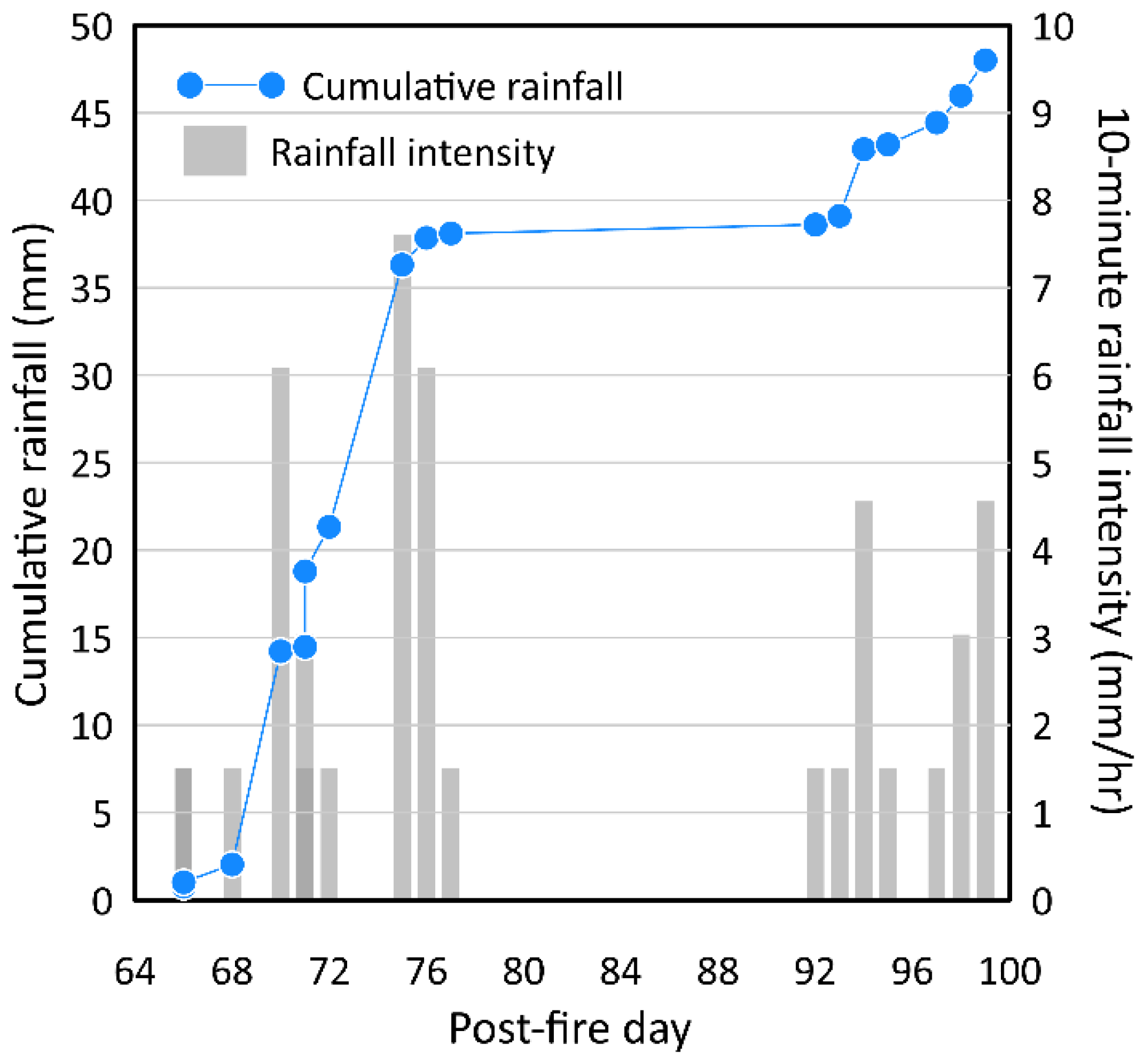
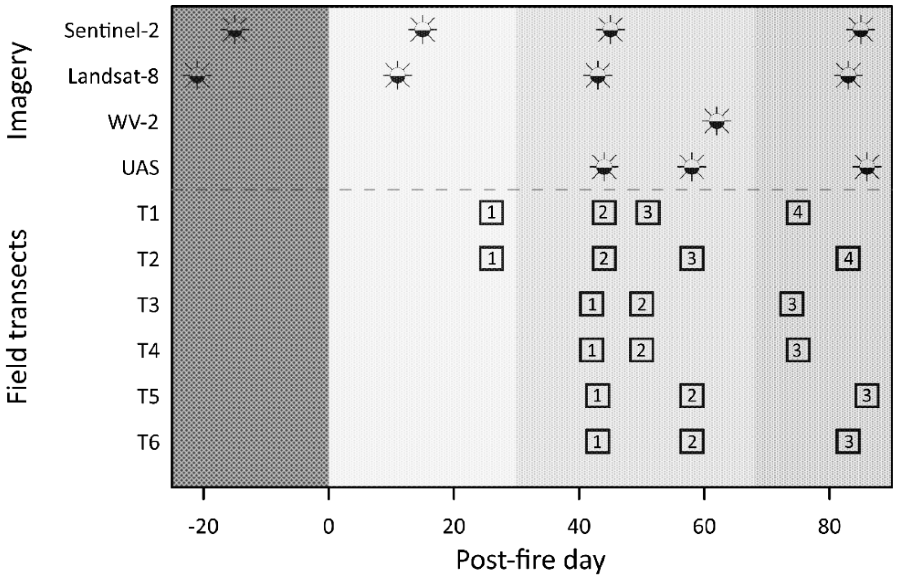
2.3. Image Acquisition and Analysis
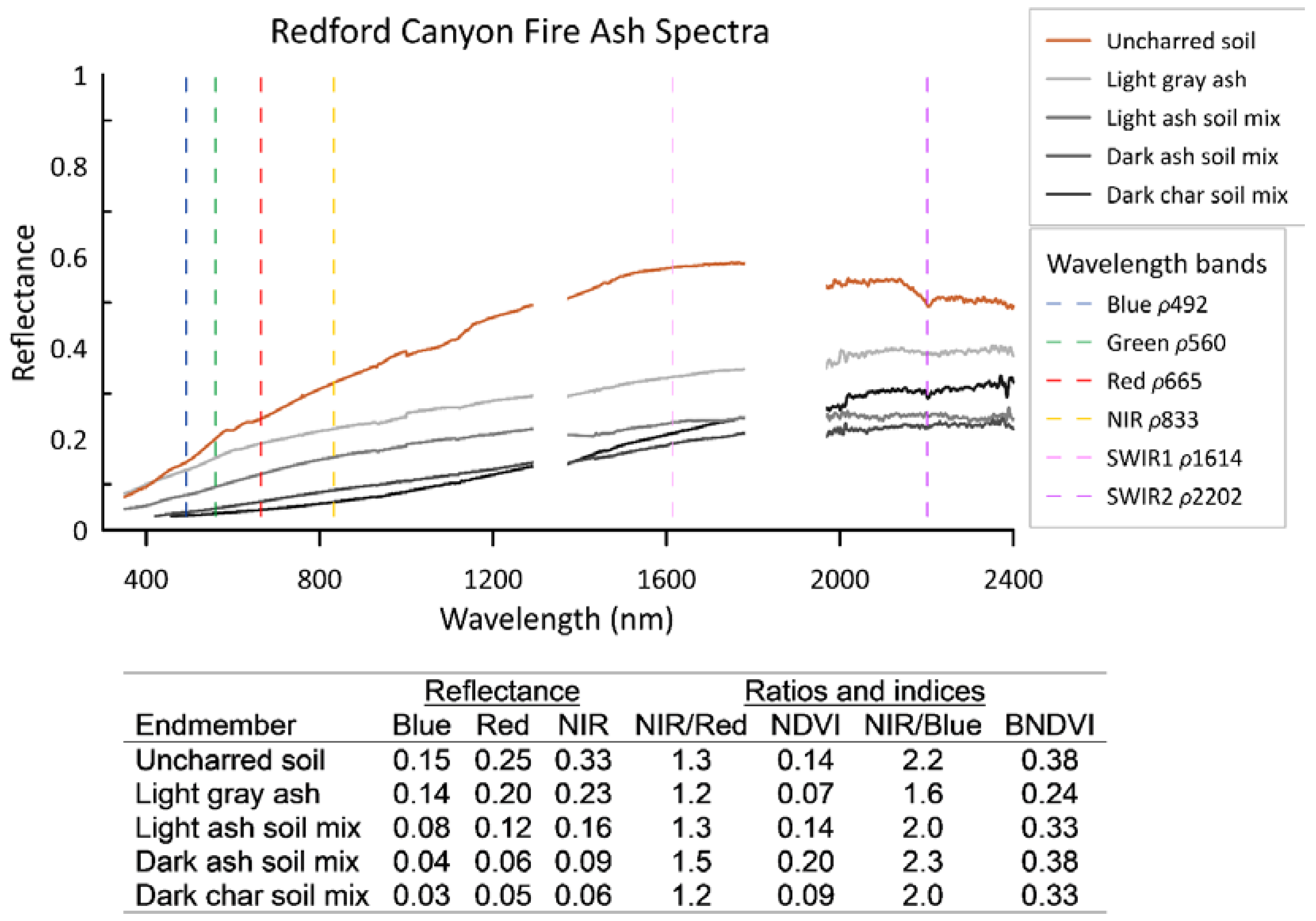
2.4. Endmember Spectra Collection
2.5. Spectral Indices
2.6. Statistical Analysis
3. Results
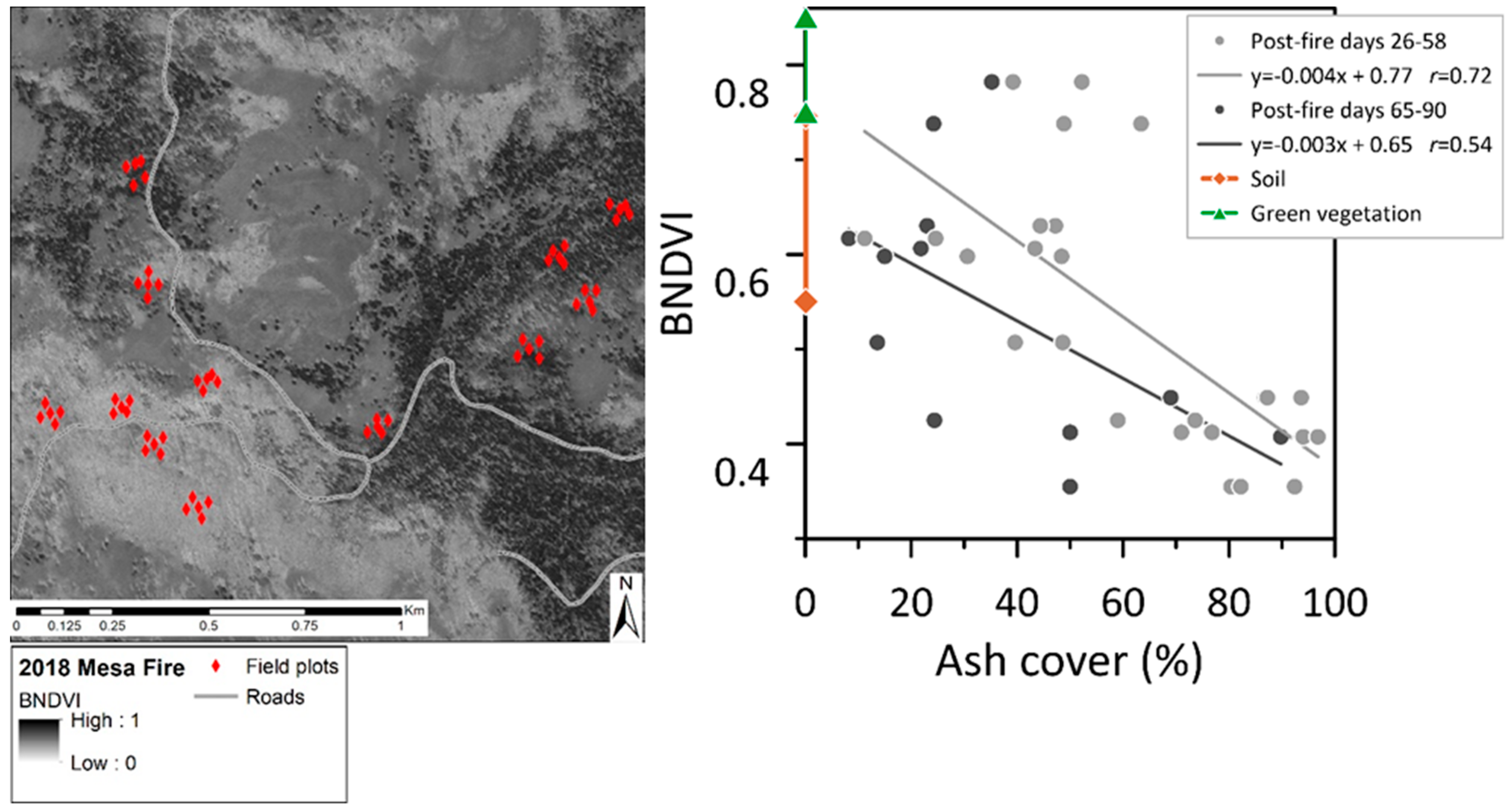
3.1. Mesa Fire Ash Cover
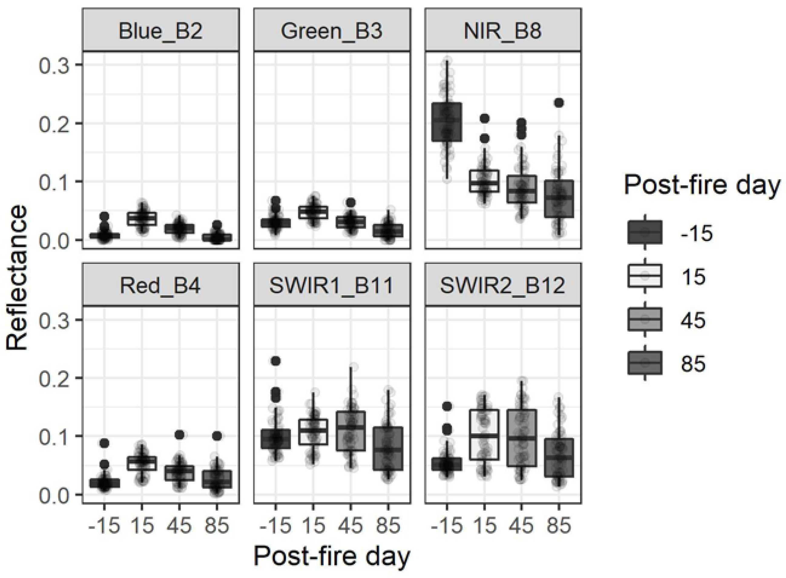
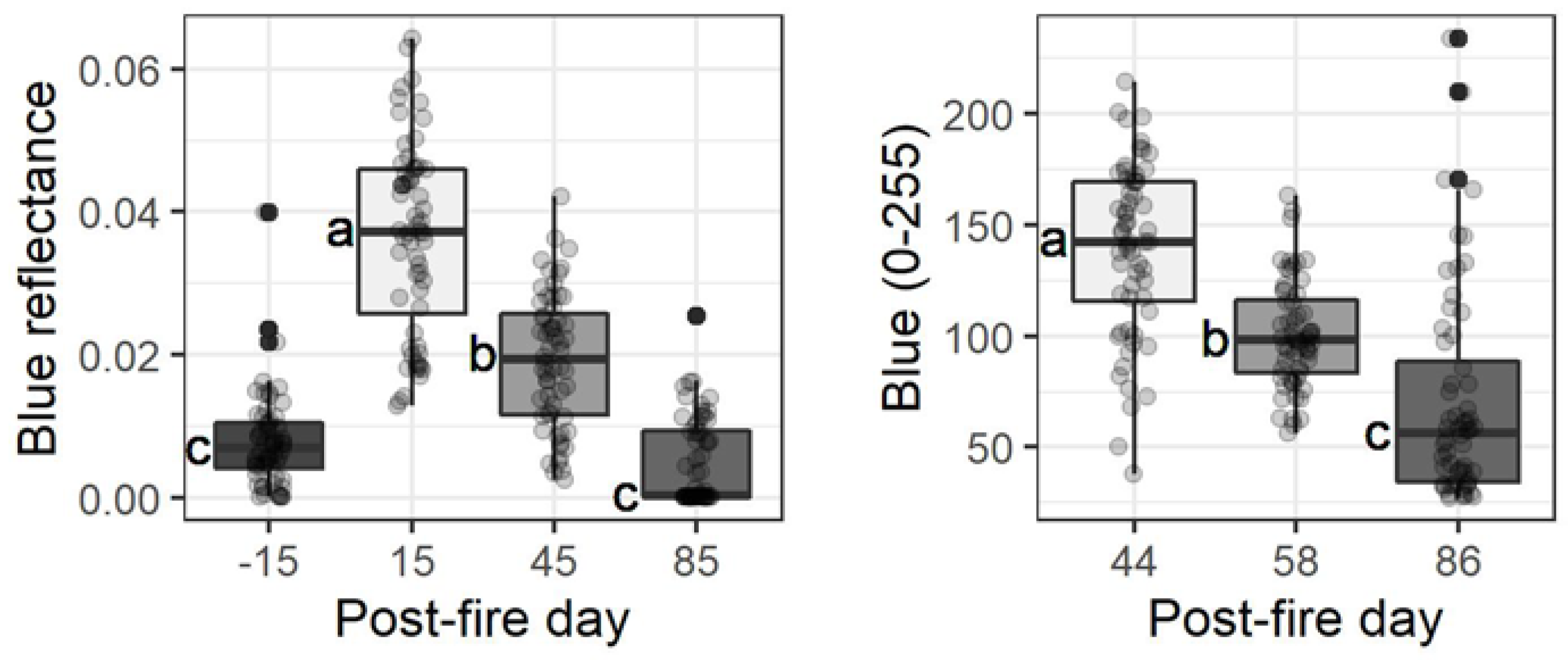
3.2. Spectral Band Analysis: Mesa Fire Plots
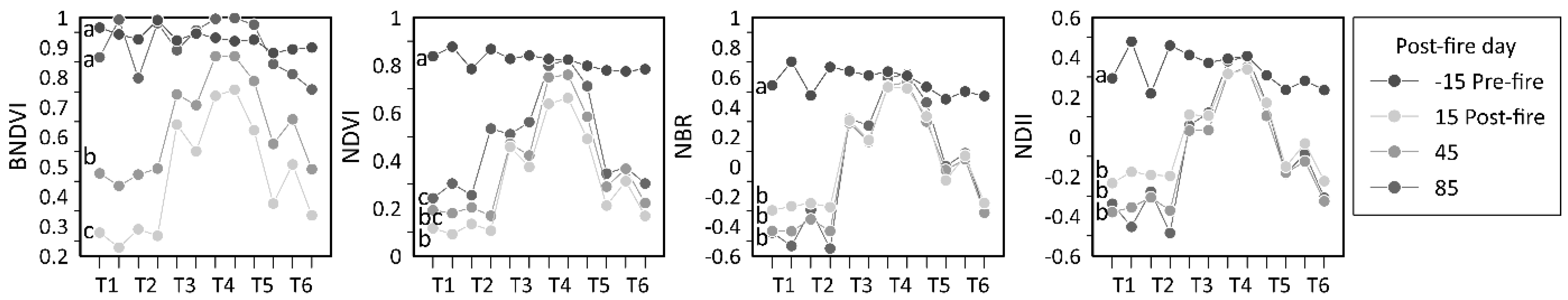
3.3. Disturbance Indices: Mesa Fire Plots
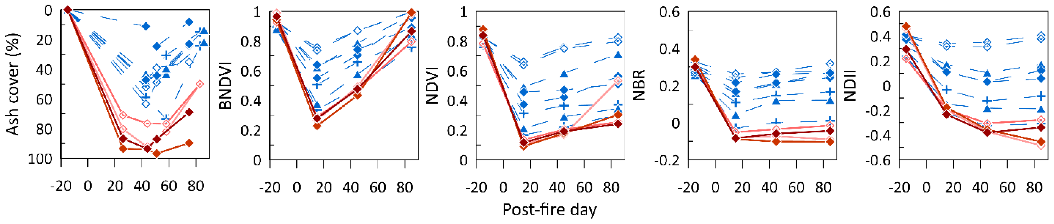
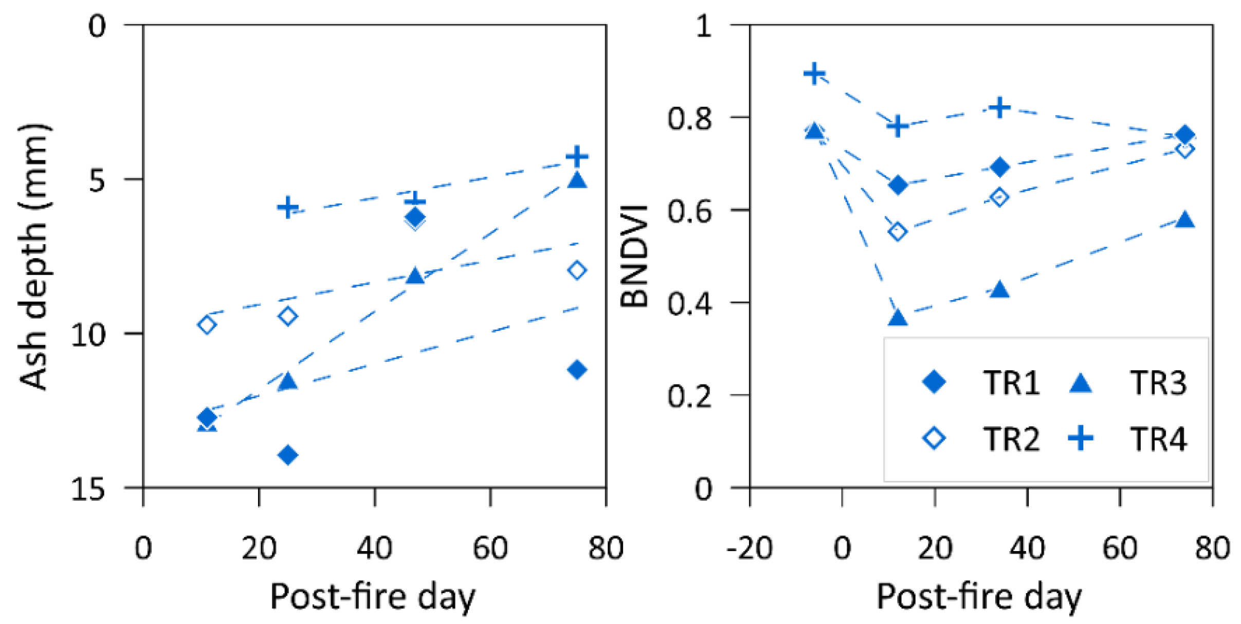
3.4. Redford Canyon Fire Pilot Study
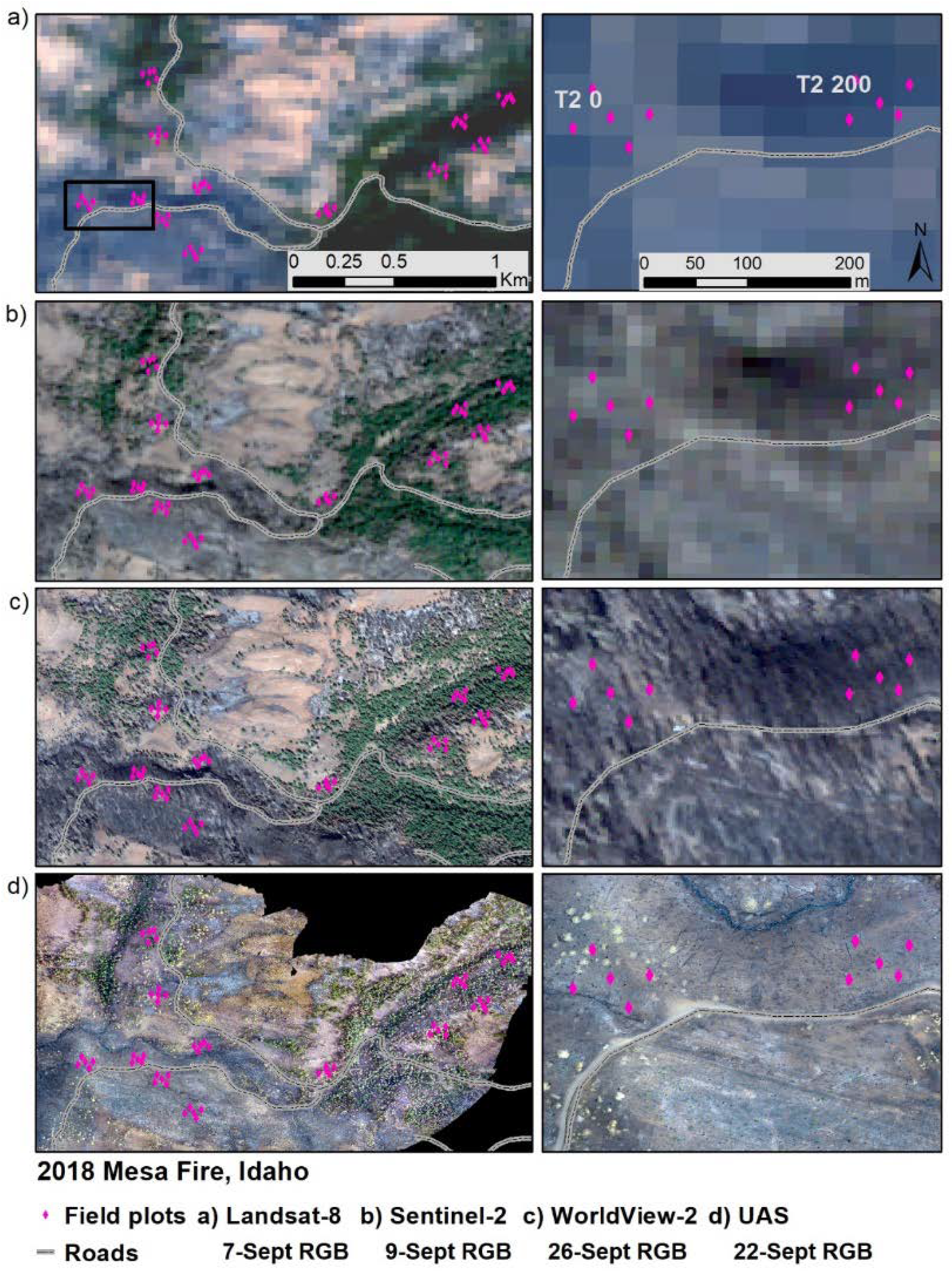
3.5. Comparing Imagery after the Mesa Fire
3.6. Mesa Fire UAS Image
3.7. Mesa Fire WorldView-2 Image
3.8. Mesa Fire Landsat Data
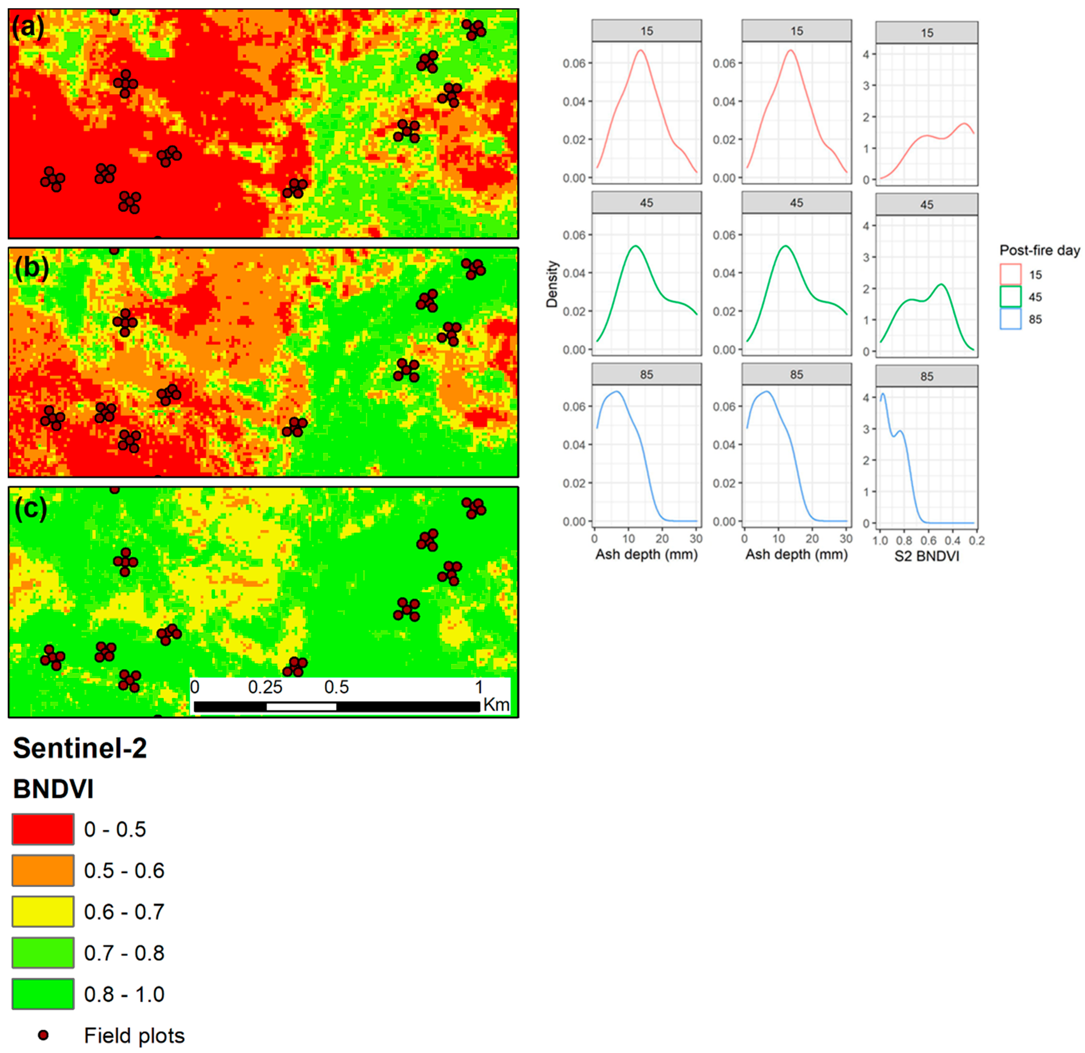
3.9. Mesa Fire Classified Sentinel-2 Time Series
4. Discussion
4.1. Change in Ash over Time
4.2. Spectral Bands and Indices
4.3. Considerations and Decision-Making Tool
5. Conclusions
Author Contributions
Funding
Institutional Review Board Statement
Informed Consent Statement
Data Availability Statement
Acknowledgments
Conflicts of Interest
References
- Westerling, A.L.; Hidalgo, H.G.; Cayan, D.R.; Swetnam, T.W. Warming and earlier spring increase western US forest wildfire activity. Science 2006, 313, 940–943. [Google Scholar] [CrossRef] [Green Version]
- Keane, R.E. Cascading Effects of Fire Exclusion in Rocky Mountain Ecosystems: A Literature Review; General Technical Report RMRS; U.S. Department of Agriculture, Forest Service, Rocky Mountain Research Station: Ft. Collins, CO, USA, 2002; pp. 1–24. [CrossRef] [Green Version]
- Pechony, O.; Shindell, D.T. Driving forces of global wildfires over the past millennium and the forthcoming century. Proc. Natl. Acad. Sci. USA 2010, 107, 19167–19170. [Google Scholar] [CrossRef] [PubMed] [Green Version]
- Kabisch, N.; Selsam, P.; Kirsten, T.; Lausch, A.; Bumberger, J. A multi-sensor and multi-temporal remote sensing approach to detect land cover change dynamics in heterogeneous urban landscapes. Ecol. Indic. 2019, 99, 273–282. [Google Scholar] [CrossRef]
- Rhoades, C.C.; Nunes, J.P.; Silins, U.; Doerr, S.H. The influence of wildfire on water quality and watershed processes: New insights and remaining challenges. Int. J. Wildl. Fire 2019, 28, 721–725. [Google Scholar] [CrossRef] [Green Version]
- Moody, J.A.; Martin, D.A. Synthesis of sediment yields after wildland fire in different rainfall regimes in the western United States. Int. J. Wildl. Fire 2009, 18, 96–115. [Google Scholar] [CrossRef]
- Shakesby, R.A.; Doerr, S.H. Wildfire as a hydrological and geomorphological agent. Earth Sci. Rev. 2006, 74, 269–307. [Google Scholar] [CrossRef]
- Robichaud, P.R.; Wagenbrenner, J.W.; Brown, R.E. Rill erosion in natural and disturbed forests: 1. Measurements. Water Resour. Res. 2010, 46, 1–14. [Google Scholar] [CrossRef]
- Smith, A.M.S.; Eitel, J.U.H.; Hudak, A.T. Spectral analysis of charcoal on soils: Implicationsfor wildland fire severity mapping methods. Int. J. Wildl. Fire 2010, 19, 976–983. [Google Scholar] [CrossRef]
- Smith, A.M.S.; Hudak, A.T. Estimating combustion of large downed woody debris from residual white ash. Int. J. Wildl. Fire 2005, 14, 245–248. [Google Scholar] [CrossRef] [Green Version]
- Hudak, A.T.; Ottmar, R.D.; Vihnanek, R.E.; Brewer, N.W.; Smith, A.M.S.; Morgan, P. The relationship of post-fire white ash cover to surface fuel consumption. Int. J. Wildl. Fire 2013, 22, 780–785. [Google Scholar] [CrossRef]
- Brewer, N.W.; Smith, A.M.S.; Hatten, J.A.; Higuera, P.E.; Hudak, A.T.; Ottmar, R.D.; Tinkham, W.T. Fuel moisture influences on fire-altered carbon in masticated fuels: An experimental study. J. Geophys. Res. Biogeosci. 2013, 118, 30–40. [Google Scholar] [CrossRef] [Green Version]
- Onda, Y.; Dietrich, W.E.; Booker, F. Evolution of overland flow after a severe forest fire, Point Reyes, California. Catena 2008, 72, 13–20. [Google Scholar] [CrossRef]
- Larsen, I.J.; MacDonald, L.H.; Brown, E.; Rough, D.; Welsh, M.J.; Pietraszek, J.H.; Libohova, Z.; Benavides-Solorio, J.D.D.; Schaffrath, K. Causes of post-fire runoff and erosion: Water repellency, cover, or soil sealing? Soil Sci. Soc. Am. J. 2009, 73, 1393–1407. [Google Scholar] [CrossRef] [Green Version]
- Woods, S.W.; Balfour, V.N. The effects of soil texture and ash thickness on the post-fire hydrological response from ash-covered soils. J. Hydrol. 2010, 393, 274–286. [Google Scholar] [CrossRef]
- Balfour, V.N.; Doerr, S.H.; Robichaud, P.R. The temporal evolution of wildfire ash and implications for post-fire infiltration. Int. J. Wildl. Fire 2014, 23, 733–745. [Google Scholar] [CrossRef] [Green Version]
- Balfour, V.N.; Woods, S.W. The hydrological properties and the effects of hydration on vegetative ash from the Northern Rockies, USA. Catena 2013, 111, 9–24. [Google Scholar] [CrossRef]
- Santín, C.; Doerr, S.H.; Otero, X.L.; Chafer, C.J. Quantity, composition and water contamination potential of ash produced under different wildfire severities. Environ. Res. 2015, 142, 297–308. [Google Scholar] [CrossRef] [Green Version]
- Robichaud, P.R.; Lewis, S.A.; Wagenbrenner, J.W.; Brown, R.E.; Pierson, F.B. Quantifying long-term post-fire sediment delivery and erosion mitigation effectiveness. Earth Surf. Process. Landf. 2020, 45, 771–782. [Google Scholar] [CrossRef]
- Bodí, M.B.; Martin, D.A.; Balfour, V.N.; Santín, C.; Doerr, S.H.; Pereira, P.; Cerdà, A.; Mataix-Solera, J. Wildland fire ash: Production, composition and eco-hydro-geomorphic effects. Earth Sci. Rev. 2014, 130, 103–127. [Google Scholar] [CrossRef]
- Burton, C.A.; Hoefen, T.M.; Plumlee, G.S.; Baumberger, K.L.; Backlin, A.R.; Gallegos, E.; Fisher, R.N. Trace elements in stormflow, ash, and burned soil following the 2009 station fire in Southern California. PLoS ONE 2016, 11, e0153372. [Google Scholar] [CrossRef]
- Nunes, J.P.; Doerr, S.H.; Sheridan, G.; Neris, J.; Santín, C.; Emelko, M.B.; Silins, U.; Robichaud, P.R.; Elliot, W.J.; Keizer, J. Assessing water contamination risk from vegetation fires: Challenges, opportunities and a framework for progress. Hydrol. Process. 2018, 32, 687–694. [Google Scholar] [CrossRef] [Green Version]
- Pereira, P.; Bogunovic, I.; Zhao, W.; Barcelo, D. Short-term effect of wildfires and prescribed fires on ecosystem services. Curr. Opin. Environ. Sci. Health 2021, 22, 100266. [Google Scholar] [CrossRef]
- Neris, J.; Santin, C.; Lew, R.; Robichaud, P.R.; Elliot, W.J.; Lewis, S.A.; Sheridan, G.; Rohlfs, A.M.; Ollivier, Q.; Oliveira, L.; et al. Designing tools to predict and mitigate impacts on water quality following the Australian 2019/2020 wildfires: Insights from Sydney’s largest water supply catchment. Integr. Environ. Assess. Manag. 2021. [Google Scholar] [CrossRef]
- Robinne, F.N.; Hallema, D.W.; Bladon, K.D.; Flannigan, M.D.; Boisramé, G.; Bréthaut, C.M.; Doerr, S.H.; Di Baldassarre, G.; Gallagher, L.A.; Hohner, A.K.; et al. Scientists’ warning on extreme wildfire risks to water supply. Hydrol. Process. 2021, 35, e14086. [Google Scholar] [CrossRef]
- Woods, S.W.; Balfour, V.N. The effect of ash on runoff and erosion after a severe forest wildfire, Montana, USA. Int. J. Wildl. Fire 2008, 17, 535–548. [Google Scholar] [CrossRef]
- Pereira, P.; Cerdà, A.; Úbeda, X.; Mataix-Solera, J.; Martin, D.; Jordán, A.; Burguet, M. Spatial models for monitoring the spatio-temporal evolution of ashes after fire—A case study of a burnt grassland in Lithuania. Solid Earth 2013, 4, 153–165. [Google Scholar] [CrossRef] [Green Version]
- Parsons, A.; Robichaud, P.R.; Lewis, S.A.; Napper, C.; Clark, J.T. Field Guide for Mapping Post-Fire Soil Burn Severity; General Technical Report RMRS-GTR-243; U.S. Department of Agriculture, Forest Service, Rocky Mountain Research Station: Ft. Collins, CO, USA, 2010.
- Miller, M.E.; Elliot, W.J.; Billmire, M.; Robichaud, P.R.; Endsley, K.A. Rapid-response tools and datasets for post-fire remediation: Linking remote sensing and process-based hydrological models. Int. J. Wildl. Fire 2016, 25, 1061–1073. [Google Scholar] [CrossRef]
- Lewis, S.A.; Hudak, A.T.; Robichaud, P.R.; Morgan, P.; Satterberg, K.L.; Strand, E.K.; Smith, A.M.S.; Zamudio, J.A.; Lentile, L.B. Indicators of burn severity at extended temporal scales: A decade of ecosystem response in mixed-conifer forests of western Montana. Int. J. Wildl. Fire 2017, 26, 755–771. [Google Scholar] [CrossRef] [Green Version]
- Hudak, A.T.; Morgan, P.; Bobbitt, M.J.; Smith, A.M.S.; Lewis, S.A.; Lentile, L.B.; Robichaud, P.R.; Clark, J.T.; Mckinley, R.A. The relationship of multispectral satellite imagery. Fire Ecol. 2007, 3, 64–90. [Google Scholar] [CrossRef]
- Kokaly, R.F.; Rockwell, B.W.; Haire, S.L.; King, T.V.V. Characterization of post-fire surface cover, soils, and burn severity at the Cerro Grande Fire, New Mexico, using hyperspectral and multispectral remote sensing. Remote Sens. Environ. 2007, 106, 305–325. [Google Scholar] [CrossRef]
- Robichaud, P.R.; Lewis, S.A.; Laes, D.Y.M.; Hudak, A.T.; Kokaly, R.F.; Zamudio, J.A. Postfire soil burn severity mapping with hyperspectral image unmixing. Remote Sens. Environ. 2007, 108, 467–480. [Google Scholar] [CrossRef] [Green Version]
- Chafer, C.J.; Santín, C.; Doerr, S.H. Modelling and quantifying the spatial distribution of post-wildfire ash loads. Int. J. Wildl. Fire 2016, 25, 249–255. [Google Scholar] [CrossRef] [Green Version]
- Key, C.H.; Benson, N.C. Landscape Assessment (LA) Sampling and Analysis Methods; General Technical Report RMRS-GTR-164-CD; U.S. Department of Agriculture, Forest Service, Rocky Mountain Research Station: Ft. Collins, CO, USA, 2006.
- Chafer, C.J. A comparison of fire severity measures: An Australian example and implications for predicting major areas of soil erosion. Catena 2008, 74, 235–245. [Google Scholar] [CrossRef]
- Lentile, L.B.; Holden, Z.A.; Smith, A.M.S.; Falkowski, M.J.; Hudak, A.T.; Morgan, P.; Lewis, S.A.; Gessler, P.E.; Benson, N.C. Remote sensing techniques to assess active fire characteristics and post-fire effects. Int. J. Wildl. Fire 2006, 15, 319–345. [Google Scholar] [CrossRef]
- Stavros, N.E.; Agha, A.; Sirota, A.; Quadrelli, M.; Ebadi, K.; Yun, K. Smoke sky–Exploring new frontiers of unmanned aerial systems for wildland fire science and applications. arXiv 2019, arXiv:1911.08288. [Google Scholar]
- Samiappan, S.; Hathcock, L.; Turnage, G.; McCraine, C.; Pitchford, J.; Moorhead, R. Remote sensing of wildfire using a small unmanned aerial system: Post-fire mapping, vegetation recovery and damage analysis in grand bay, Mississippi/Alabama, USA. Drones 2019, 3, 43. [Google Scholar] [CrossRef] [Green Version]
- Hamilton, D.; Bowerman, M.; Colwell, J.; Donohoe, G.; Myers, B. Spectroscopic analysis for mapping wildland fire effects from remotely sensed imagery. J. Unmanned Veh. Syst. 2017, 5, 146–158. [Google Scholar] [CrossRef] [PubMed] [Green Version]
- Xue, J.; Su, B. Significant remote sensing vegetation indices: A review of developments and applications. J. Sens. 2017, 2017, 1353691. [Google Scholar] [CrossRef] [Green Version]
- Melville, B.; Fisher, A.; Lucieer, A. Ultra-high spatial resolution fractional vegetation cover from unmanned aerial multispectral imagery. Int. J. Appl. Earth Obs. Geoinf. 2019, 78, 14–24. [Google Scholar] [CrossRef]
- Williams, C.K.; Kelley, B.F.; Smith, B.G.; Lillybridge, T.R. Forested Plant Associations of the Colville National Forest; General Technical Report PNW-GTR-36; US Department of Agriculture, Forest Service, Pacific Northwest Research Station: Portland, OR, USA, 1995.
- Lentile, L.; Morgan, P.; Hardy, C.; Hudak, A.; Means, R.; Ottmar, R.; Robichaud, P.; Sutherland, E.K.; Szymoniak, J.; Way, F.; et al. Value and Challenges of Conducting Rapid Response Research on Wildland Fires; General Technical Report RMRS-GTR-193; U.S. Department of Agriculture, Forest Service, Rocky Mountain Research Station: Fort Collins, CO, USA, 2007.
- Steinfeld, D.; Kern, J.; Gallant, G.; Riley, S. Monitoring roadside revegetation projects. Nativ. Plants J. 2011, 12, 269–275. [Google Scholar] [CrossRef]
- Main-Knorn, M.; Pflug, B.; Louis, J.; Debaecker, V.; Müller-Wilm, U.; Gascon, F. Sen2Cor for Sentinel-2. In Image and Signal Processing for Remote Sensing XXIII; International Society for Optics and Photonics: Bellingham, WA, USA, 2017; p. 10427. [Google Scholar] [CrossRef] [Green Version]
- Ranghetti, L.; Boschetti, M.; Nutini, F.; Busetto, L. “sen2r”: An R toolbox for automatically downloading and preprocessing Sentinel-2 satellite data. Comput. Geosci. 2020, 139, 104473. [Google Scholar] [CrossRef]
- Fernández, C.; Fernández-Alonso, J.M.; Vega, J.A. Exploring the effect of hydrological connectivity and soil burn severity on sediment yield after wildfire and mulching. Land Degrad. Dev. 2020, 31, 1611–1621. [Google Scholar] [CrossRef]
- Navarro, G.; Caballero, I.; Silva, G.; Parra, P.C.; Vázquez, Á.; Caldeira, R. Evaluation of forest fire on Madeira Island using Sentinel-2A MSI imagery. Int. J. Appl. Earth Obs. Geoinf. 2017, 58, 97–106. [Google Scholar] [CrossRef] [Green Version]
- Roy, D.P.; Boschetti, L.; Trigg, S.N. Remote sensing of fire severity: Assessing the performance of the normalized burn ratio. IEEE Geosci. Remote Sens. Lett. 2006, 3, 112–116. [Google Scholar] [CrossRef] [Green Version]
- Carlson, T.N.; Ripley, D.A. On the relation between NDVI, fractional vegetation cover, and leaf area index. Remote Sens. Environ. 1997, 62, 241–252. [Google Scholar] [CrossRef]
- Escuin, S.; Navarro, R.; Fernández, P. Fire severity assessment by using NBR (Normalized Burn Ratio) and NDVI (Normalized Difference Vegetation Index) derived from LANDSAT TM/ETM images. Int. J. Remote Sens. 2008, 29, 1053–1073. [Google Scholar] [CrossRef]
- Fernández-Manso, A.; Fernández-Manso, O.; Quintano, C. SENTINEL-2A red-edge spectral indices suitability for discriminating burn severity. Int. J. Appl. Earth Obs. Geoinf. 2016, 50, 170–175. [Google Scholar] [CrossRef]
- Wang, F.; Huang, J.; Tang, Y.; Wang, X. New vegetation index and its application in estimating leaf area index of rice. Rice Sci. 2007, 14, 195–203. [Google Scholar] [CrossRef]
- Mpakairi, K.S.; Kadzunge, S.L.; Ndaimani, H. Testing the utility of the blue spectral region in burned area mapping: Insights from savanna wildfires. Remote Sens. Appl. Soc. Environ. 2020, 20, 100365. [Google Scholar] [CrossRef]
- Tucker, C.J. Red and photographic infrared linear combinations for monitoring vegetation. Remote Sens. Environ. 1979, 8, 127. [Google Scholar] [CrossRef] [Green Version]
- Littell, R.C.; Milliken, G.A.; Stroup, W.W.; Wolfinger, R.D.; Oliver, S. SAS for Mixed Models, 2nd ed.; SAS Publishing: Cary, NC, USA, 2006; ISBN 1590475003. [Google Scholar]
- Lentile, L.B.; Smith, A.M.S.; Hudak, A.T.; Morgan, P.; Bobbitt, M.J.; Lewis, S.A.; Robichaud, P.R. Remote sensing for prediction of 1-year post-fire ecosystem condition. Int. J. Wildl. Fire 2009, 18, 594–608. [Google Scholar] [CrossRef] [Green Version]
- Van Wagtendonk, J.W.; Root, R.R.; Key, C.H. Comparison of AVIRIS and Landsat ETM+ detection capabilities for burn severity. Remote Sens. Environ. 2004, 92, 397–408. [Google Scholar] [CrossRef]
- Robichaud, P.R.; Lewis, S.A.; Wagenbrenner, J.W.; Ashmun, L.E.; Brown, R.E. Post-fire mulching for runoff and erosion mitigation. Part I: Effectiveness at reducing hillslope erosion rates. Catena 2013, 105, 75–92. [Google Scholar] [CrossRef]
- Pannkuk, C.D.; Robichaud, P.R. Effectiveness of needle cast at reducing erosion after forest fires. Water Resour. Res. 2003, 39, 1–9. [Google Scholar] [CrossRef]
- Zou, X.; Haikarainen, I.; Haikarainen, I.P.; Mäkelä, P.; Mõttus, M.; Pellikka, P. Effects of crop leaf angle on LAI-sensitive narrow-band vegetation indices derived from imaging spectroscopy. Appl. Sci. 2018, 8, 1435. [Google Scholar] [CrossRef] [Green Version]
- Estrany, J.; Ruiz, M.; Calsamiglia, A.; Carriquí, M.; García-Comendador, J.; Nadal, M.; Fortesa, J.; López-Tarazón, J.A.; Medrano, H.; Gago, J. Sediment connectivity linked to vegetation using UAVs: High-resolution imagery for ecosystem management. Sci. Total Environ. 2019, 671, 1192–1205. [Google Scholar] [CrossRef]
- Ngadze, F.; Mpakairi, K.S.; Kavhu, B.; Ndaimani, H.; Maremba, M.S. Exploring the utility of Sentinel-2 MSI and Landsat 8 OLI in burned area mapping for a heterogenous savannah landscape. PLoS ONE 2020, 15, 1–13. [Google Scholar] [CrossRef] [PubMed]
- García-Llamas, P.; Suárez-Seoane, S.; Fernández-Guisuraga, J.M.; Fernández-García, V.; Fernández-Manso, A.; Quintano, C.; Taboada, A.; Marcos, E.; Calvo, L. Evaluation and comparison of Landsat 8, Sentinel-2 and Deimos-1 remote sensing indices for assessing burn severity in Mediterranean fire-prone ecosystems. Int. J. Appl. Earth Obs. Geoinf. 2019, 80, 137–144. [Google Scholar] [CrossRef]
- Veraverbeke, S.; Hook, S.J. Evaluating spectral indices and spectral mixture analysis for assessing fire severity, combustion completeness and carbon emissions. Int. J. Wildl. Fire 2013, 22, 707–720. [Google Scholar] [CrossRef]
- Quintano, C.; Fernández-Manso, A.; Roberts, D.A. Enhanced burn severity estimation using fine resolution ET and MESMA fraction images with machine learning algorithm. Remote Sens. Environ. 2020, 244, 111815. [Google Scholar] [CrossRef]
- Fernández-Guisuraga, J.M.; Sanz-Ablanedo, E.; Suárez-Seoane, S.; Calvo, L. Using unmanned aerial vehicles in postfire vegetation survey campaigns through large and heterogeneous areas: Opportunities and challenges. Sensors 2018, 18, 586. [Google Scholar] [CrossRef] [PubMed] [Green Version]
- Colson, D.; Petropoulos, G.P.; Ferentinos, K.P. Exploring the potential of Sentinels-1 & 2 of the Copernicus Mission in support of rapid and cost-effective wildfire assessment. Int. J. Appl. Earth Obs. Geoinf. 2018, 73, 262–276. [Google Scholar] [CrossRef]
- Wu, Z.; Middleton, B.; Hetzler, R.; Vogel, J.; Dye, D. Vegetation burn severity mapping using Landsat-8 and Worldview-2. Photogramm. Eng. Remote Sens. 2015, 81, 143–154. [Google Scholar] [CrossRef]


| Landsat-8 | Sentinel-2 | WorldView-2 | |||||||
|---|---|---|---|---|---|---|---|---|---|
| Band | Central Wavelength (nm) | Span (nm) | Pixel (m) | Central Wavelength (nm) | Span (nm) | Pixel (m) | Central Wavelength (nm) | Span (nm) | Pixel (m) |
| Blue | 482 [B2] | 435–451 | 30 | 492 [B2] | 459–525 | 10 | 478 [B2] | 450–510 | 1.8 |
| Green | 561 [B3] | 452–512 | 30 | 560 [B3] | 542–578 | 10 | 546 [B3] | 510–580 | 1.8 |
| Red | 655 [B4] | 636–673 | 30 | 665 [B4] | 650–681 | 10 | 659 [B5] | 630–690 | 1.8 |
| NIR | 865 [B5] | 851–879 | 30 | 833 [B8a] 1 | 780–886 | 10 | 831 [B7] | 770–895 | 1.8 |
| SWIR1 | 1609 [B6] | 1567–1651 | 30 | 1614 [B11] | 1569–1660 | 20 | - | - | - |
| SWIR2 | 2201 [B7] | 2107–2294 | 30 | 2202 [B12] | 2115–2290 | 20 | - | - | - |
| Scheme 2 | Equation | Citation |
|---|---|---|
| Normalized Burn Ratio | Key and Benson 2006 [35] | |
| Normalized Difference Vegetation Index | Tucker 1979 [56] | |
| Blue Normalized Difference Vegetation Index | Wang et al. 2007 [54] | |
| Normalized Difference Infrared Index | Chafer et al. 2016 [34] |
| Initial Ash Data | ||||||
|---|---|---|---|---|---|---|
| Fire | Transect | Burn Severity | Plots (n) | Ash Bulk Density (g·cm−3) | Cover (%) | Depth (mm) |
| Mesa | T1 | High | 10 | 0.28 | 90 | 17 |
| T2 | High | 10 | 0.44 | 76 | 14 | |
| T3 | Low/moderate | 10 | - | 29 | 23 | |
| T4 | Low/moderate | 10 | - | 58 | 14 | |
| T5 | Low/moderate | 10 | - | 46 | 7 | |
| T6 | Low/moderate | 10 | - | 54 | 9 | |
| Redford | TR1 | Moderate | 9 | - | - | 13 |
| Canyon | TR2 | Moderate | 9 | - | - | 10 |
| TR3 | Moderate-high | 9 | 0.32 | - | 13 | |
| TR4 | Moderate | 9 | - | - | 8 | |
| Post-Fire Day | Burn Severity | Ash Cover Estimate (%) | Standard Error | Letter Group |
|---|---|---|---|---|
| 15 | 71 | 6.7 | a | |
| 45 | 69 | 4.6 | a | |
| 85 | 48 | 5.5 | b | |
| High | 82 | 5.4 | a | |
| Low/moderate | 32 | 4.0 | b |
| Platform/Satellite | Bands Used (as Available) | Acquisition/Return Period | Cost per 100 km2 | Time to Process | Area and Specifications | Data Volume | |
|---|---|---|---|---|---|---|---|
| UAS | Specs: | RGB (NIR) | As collected | $16,000 1 (16 days) | Days | 4 km2 3-band | Ultra-high (1.5 GB) |
| Pros: |
| ||||||
| Cons: |
| ||||||
| World View-2 | Specs: | RGB/NIR (SWIR on WV-3) | Tasked/as ordered | $2500 | Hours | 100 km2 orthorectified 4-band | Moderate (300 MB) |
| Pros: |
| ||||||
| Cons: |
| ||||||
| Sentinel-2 | Specs: | RGB/NIR/SWIR | Automatic/5–10 days | Free | Hours | 100 km2 orthorectified 12-band | Moderate (600–800 MB) |
| Pros: |
| ||||||
| Cons: |
| ||||||
| Landsat-8 | Specs: | RGB/NIR/SWIR | Automatic/16 days | Free | Hours | 300 km2 orthorectified 11-bands | Moderate (900+ MB) |
| Pros: |
| ||||||
| Cons: |
| ||||||
Publisher’s Note: MDPI stays neutral with regard to jurisdictional claims in published maps and institutional affiliations. |
© 2021 by the authors. Licensee MDPI, Basel, Switzerland. This article is an open access article distributed under the terms and conditions of the Creative Commons Attribution (CC BY) license (https://creativecommons.org/licenses/by/4.0/).
Share and Cite
Lewis, S.A.; Robichaud, P.R.; Hudak, A.T.; Strand, E.K.; Eitel, J.U.H.; Brown, R.E. Evaluating the Persistence of Post-Wildfire Ash: A Multi-Platform Spatiotemporal Analysis. Fire 2021, 4, 68. https://doi.org/10.3390/fire4040068
Lewis SA, Robichaud PR, Hudak AT, Strand EK, Eitel JUH, Brown RE. Evaluating the Persistence of Post-Wildfire Ash: A Multi-Platform Spatiotemporal Analysis. Fire. 2021; 4(4):68. https://doi.org/10.3390/fire4040068
Chicago/Turabian StyleLewis, Sarah A., Peter R. Robichaud, Andrew T. Hudak, Eva K. Strand, Jan U. H. Eitel, and Robert E. Brown. 2021. "Evaluating the Persistence of Post-Wildfire Ash: A Multi-Platform Spatiotemporal Analysis" Fire 4, no. 4: 68. https://doi.org/10.3390/fire4040068
APA StyleLewis, S. A., Robichaud, P. R., Hudak, A. T., Strand, E. K., Eitel, J. U. H., & Brown, R. E. (2021). Evaluating the Persistence of Post-Wildfire Ash: A Multi-Platform Spatiotemporal Analysis. Fire, 4(4), 68. https://doi.org/10.3390/fire4040068