Half-Century Changes in LULC and Fire in Two Iberian Inner Mountain Areas

 ,
,
Abstract
:1. Introduction
2. Methodology
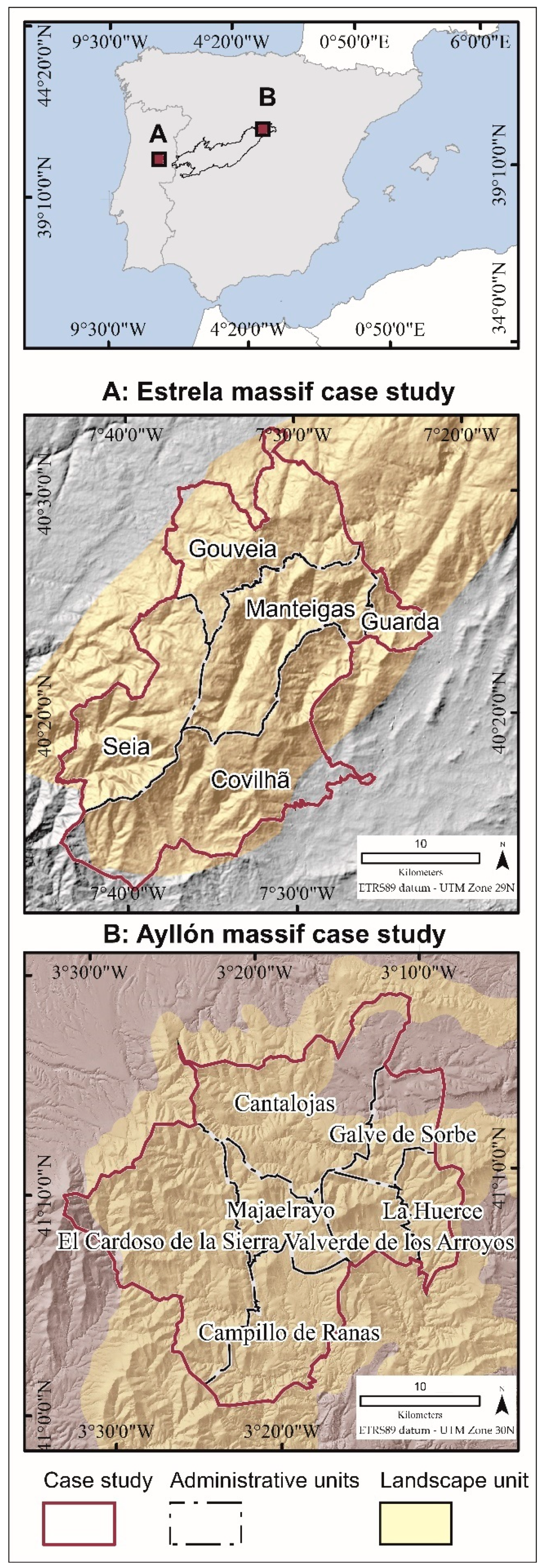
2.1. Study Area
2.2. Data Gathering
2.3. Data Analysis
3. Results and Discussion
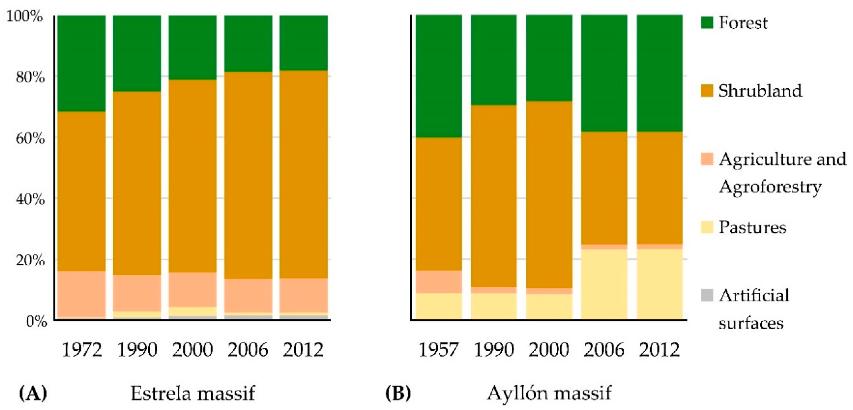
3.1. Land Use/Land Cover Changed through Time
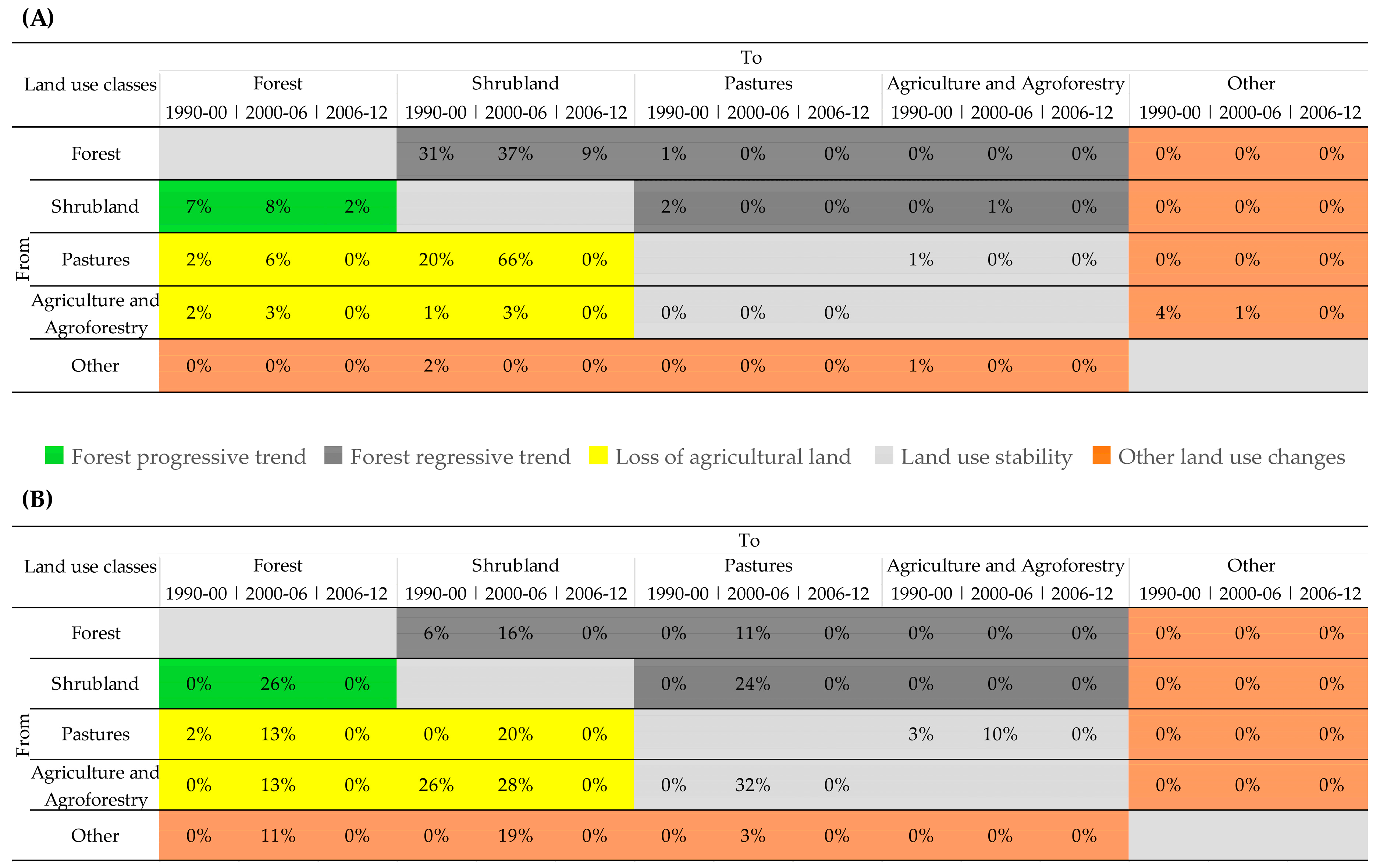
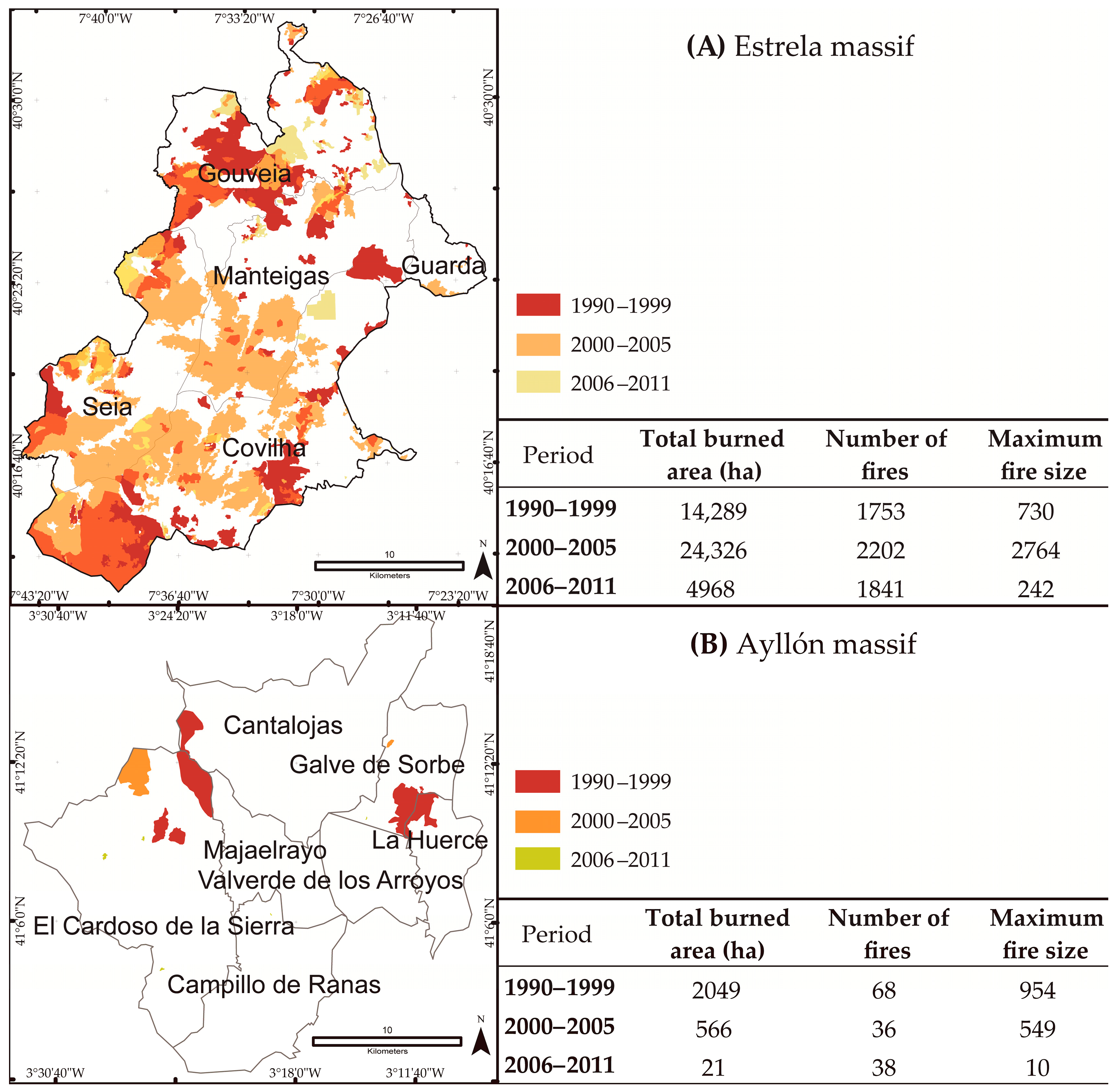
3.2. Fire and Land Use/Land Cover Are Related
3.3. Forest Composition Changed through Time, and Fire and Forest Composition Are Related
3.4. Value, Limitations and Future Research
4. Conclusions
Supplementary Materials
Author Contributions
Funding
Acknowledgments
Conflicts of Interest
References
- Fernández, D.; Corbelle, E. Cambios en los usos de suelo en la Península Ibérica: Un meta-análisis para el período 1985–2015. Rev. Bibliográfica Geogr. Ciencias Soc. 2017, 21, 215. [Google Scholar]
- Moreira, F.; Viedma, O.; Arianoutsou, M.; Curt, T.; Koutsias, N.; Rigolot, E.; Barbati, A.; Corona, P.; Vaz, P.; Xanthopoulos, G.; et al. Landscape—wildfire interactions in southern Europe: Implications for landscape management. J. Environ. Manag. 2011, 92, 2389–2402. [Google Scholar] [CrossRef] [PubMed]
- Rego, F.C. Land use changes and wildfires. In Responses of Forest Ecosystems to Environmental Changes; Teller, A., Mathy, P., Jeffers, J.N.R., Eds.; Springer: Dordrecht, The Netherlands; Luxembourg, 1992; pp. 367–368. ISBN 978-94-011-2866-7. [Google Scholar]
- Silva, J.S.; Vaz, P.; Moreira, F.; Catry, F.; Rego, F.C. Wildfires as a major driver of landscape dynamics in three fire-prone areas of Portugal. Landsc. Urban Plan. 2011, 101, 349–358. [Google Scholar] [CrossRef] [Green Version]
- Meneses, B.; Reis, E.; Pereira, S.S.; Vale, M.J. Understanding driving forces and implications associated with the land use and land cover changes in portugal. Sustainability 2017, 9, 351. [Google Scholar] [CrossRef]
- Plieninger, T.; Draux, H.; Fagerholm, N.; Bieling, C.; Bürgi, M.; Kizos, T.; Kuemmerle, T.; Primdahl, J.; Verburg, P.H. The driving forces of landscape change in Europe: A systematic review of the evidence. Land Use Policy 2016, 57, 204–214. [Google Scholar] [CrossRef] [Green Version]
- Vilar, L.; Camia, A.; San-Miguel-Ayanz, J.; Martín, M.P. Modeling temporal changes in human-caused wildfires in Mediterranean Europe based on land use-land cover interfaces. For. Ecol. Manag. 2016, 378, 68–78. [Google Scholar] [CrossRef]
- Paniagua, A.; Hoggart, K. The restructuring of rural Spain? J. Rural Stud. 2001, 17, 63–80. [Google Scholar]
- Viedma, O.; Moity, N.; Moreno, J.M. Changes in landscape fire-hazard during the second half of the 20th century: Agriculture abandonment and the changing role of driving factors. Agric. Ecosyst. Environ. 2015, 207, 126–140. [Google Scholar] [CrossRef]
- Montiel-Molina, C. Presencia Histórica Del Fuego En El Territorio; Ministerio de Agricultura y Pesca Alimentación y Medio Ambiente (MAPAMA): Madrid, Spain, 2013; ISBN 978-84-491-1289-8.
- García Novo, F.; Casal, M.; Pausas, J.G. Ecología De La Regeneración De Zonas Incendiadas; Academia de Ciencias Sociales y del Medio Ambiente de Andalucía: Sevilla, Spain, 2018; ISBN 978-84-09-05946-1. [Google Scholar]
- Gallardo, M.; Gómez, I.; Vilar, L.; Martínez-Vega, J.; Martín, M.P. Impacts of future land use/land cover on wildfire occurrence in the Madrid region (Spain). Reg. Environ. Chang. 2016, 16, 1047–1061. [Google Scholar] [CrossRef]
- Viedma, O.; Moreno, J.M.; Rieiro, I. Interactions between land use/land cover change, forest fires and landscape structure in Sierra de Gredos (Central Spain). Environ. Conserv. 2006, 33, 212–222. [Google Scholar] [CrossRef]
- Nunes, A.; Lourenço, L.; Meira, A.C. Exploring spatial patterns and drivers of forest fires in Portugal (1980–2014). Sci. Total Environ. 2016, 573, 1190–1202. [Google Scholar] [CrossRef] [PubMed]
- Martínez de Pisón, E.; Molina Holgado, P. Diversidad del paisaje natural. In La Diversidad Biológica De España; Pineda, F.D., Ed.; Prentice Hall: Madrid, Spain, 2002; pp. 33–44. ISBN 9788420535159. [Google Scholar]
- Janssen, C.R.; Woldringh, R.E. A preliminary radiocarbon dated pollen sequence from the Serra da Estrela, Portugal. Finisterra 1981, 16, 299–309. [Google Scholar] [CrossRef]
- Ribeiro, C.; Delgado, J.N. Relatório Acerca Da Arborisação Geral Do Paíz Apresentada A Sua Excellencia O Ministro Das Obras Publicas, Commercio E Industria Em Resposta Aos Quesitos do Artigo 1o Do Decreto De 24 de Setembro de 1867; Typographia da Academia Real das Sciencias: Lisboa, Portugal, 1868. [Google Scholar]
- Caetano, M.; Marcelino, F. CORINE Land Cover de Portugal Continental 1990-2000-2006-2012-Relatório Tecnico; Direção-Geral do Território (DGT): Lisboa, Portugal, 2017. [Google Scholar]
- Watson, R.T.; Noble, I.R.; Bolib, B.; Ravindranath, N.H.; Verardo, D.J.; Dokken, D.J. Land Use, Land-Use Change and Forestry: A Special Report of the Intergovernmental Panel on Climate Change 2000; Cambridge University Press: London, UK, 2000. [Google Scholar]
- Silva, J.; Moreira, F.; Vaz, P.; Catry, F.; Ferreira, P. Assessing the relative fire proneness of different forest types in Portugal. Plant Biosyst. 2009, 143, 597–608. [Google Scholar] [CrossRef]
- Meneses, B.; Reis, E.; Reis, R. Assessment of the recurrence interval of wildfires in mainland Portugal and affected LUC patterns identification. J. Maps 2018, 14, 282–292. [Google Scholar] [CrossRef]
- Marques, S.; Borges, J.G.; Garcia-Gonzalo, J.; Moreira, F. Characterization of wildfires in Portugal. Eur. J. For. Res. 2011, 130, 775–784. [Google Scholar] [CrossRef]
- Nunes, M.C.S.; Vasconcelos, M.J.; Pereira, J.M.C.; Dasgupta, N.; Alldredge, R.J.; Rego, F.C. Land cover type and fire in Portugal: Do fires burn land cover selectively? Landsc. Ecol. 2005, 20, 661–673. [Google Scholar] [CrossRef]
- Postigo-Mijarra, J.M.; Génova, M.; Gómez-Manzaneque, F.; Martínez-García, F.; Morla, C.; Vegas, J.; Perucha, M.Á. Occurrence of continuous Holocene pinewoods (Pinus sylvestris L.) in the Eastern Central System (Spain) inferred from macroremains. New data from the Sandria site. Rev. Palaeobot. Palynol. 2017, 246, 70–84. [Google Scholar] [CrossRef]
- Franco Múgica, F.; García Antón, M.; Maldonado Ruiz, J.; Morla Juaristi, C.; Sainz Ollero, H. Evolución de la vegetación en el sector septentrional del macizo de Ayllón (Sistema Central). Análisis polínico de la turbera de Pelagallinas. An. del Jardín Botánico Madri 2001, 59, 113–124. [Google Scholar]
- Gómez de Mendoza, J.; Mata, R. Actuaciones forestales públicas desde 1940. Objetivos, criterios y resultados. Agric. Soc. 1992, 65, 15–64. [Google Scholar]
- Montiel-Molina, C.; Karlsson-Martín, O.; Galiana-Martín, L. Regional fire scenarios in Spain: Linking landscape dynamics and fire regime for wildfire risk management. J. Environ. Manag. 2018, 233, 427–439. [Google Scholar] [CrossRef]
- Moreno, M.V.; Conedera, M.; Chuvieco, E.; Pezzatti, G.B. Fire regime changes and major driving forces in Spain from 1968 to 2010. Environ. Sci. Policy 2014, 37, 11–22. [Google Scholar] [CrossRef]
- Pausas, J.G.; Fernández-Muñoz, S. Fire regime changes in the Western Mediterranean Basin: From fuel-limited to drought-driven fire regime. Clim. Chang. 2012, 110, 215–226. [Google Scholar] [CrossRef]
- Silva, J.M.N.; Moreno, M.V.; Le Page, Y.; Oom, D.; Bistinas, I.; Pereira, J.M.C. Spatiotemporal trends of area burnt in the Iberian Peninsula, 1975–2013. Reg. Environ. Chang. 2018. [Google Scholar] [CrossRef]
- Jiménez-Ruano, A.; Rodrigues Mimbrero, M.; De La Riva Fernández, J. Exploring spatial–temporal dynamics of fire regime features in mainland Spain. Nat. Hazards Earth Syst. Sci. 2017, 17, 1697–1711. [Google Scholar] [CrossRef]
- Pausas, J.G. Simulating Mediterranean landscape pattern and vegetation dynamics under different fire regimes. Plant Ecol. 2006, 187, 249–259. [Google Scholar] [CrossRef]
- Fernandes, P.; Luz, A.; Loureiro, C.; Ferreira-Godinho, P.; Botelho, H. Fuel modelling and fire hazard assessment based on data from the Portuguese National Forest Inventory. For. Ecol. Manag. 2006, 234, S229. [Google Scholar] [CrossRef]
- Nunes, A.N. Regional variability and driving forces behind forest fires in Portugal an overview of the last three decades (1980–2009). Appl. Geogr. 2012, 34, 576–586. [Google Scholar] [CrossRef]
- Martínez-Fernandéz, J.; Vega-garcía, C.; Chuvieco, E. Human-caused wildfire risk rating for prevention planning in Spain. J. Environ. Manag. 2008, 90, 1241–1252. [Google Scholar] [CrossRef]
- Rego, F.; Louro, G.; Constantino, L. The impact of changing wildfire regimes on wood availability from Portuguese forests. For. Policy Econ. 2013, 29, 56–61. [Google Scholar] [CrossRef] [Green Version]
- Barros, A.M.G.; Pereira, J.M.C. Wildfire selectivity for land cover type: Does size matter? PLoS ONE 2014, 9, e84760. [Google Scholar] [CrossRef]
- Moreira, F.; Vaz, P.; Catry, F.; Silva, J.S. Regional variations in wildfire susceptibility of land-cover types in Portugal: Implications for landscape management to minimize fire hazard. Int. J. Wildland Fire 2009, 18, 563–574. [Google Scholar] [CrossRef]
- Sebastián-López, A.; Salvador-Civil, R.; Gonzalo-Jiménez, J.; SanMiguel-Ayanz, J. Integration of socio-economic and environmental variables for modelling long-term fire danger in Southern Europe. Eur. J. For. Res. 2008, 127, 149–163. [Google Scholar] [CrossRef]
- Moreno, J.M.; Viedma, O.; Zavala, G.; Luna, B. Landscape variables influencing forest fires in central Spain. Int. J. Wildland Fire 2011, 20, 678–689. [Google Scholar] [CrossRef] [Green Version]
- Verdú, F.; Salas, J.; Vega-García, C. A multivariate analysis of biophysical factors and forest fires in Spain, 1991-2005. Int. J. Wildland Fire 2012, 21, 498. [Google Scholar] [CrossRef]
- Martínez-Fernández, J.; Chuvieco, E.; Koutsias, N. Modelling long-term fire occurrence factors in Spain by accounting for local variations with geographically weighted regression. Nat. Hazards Earth Syst. Sci. 2013, 13, 311–327. [Google Scholar] [CrossRef]
- Moreira, F.; Catry, F.X.; Rego, F.; Bacao, F. Size-dependent pattern of wildfire ignitions in Portugal: When do ignitions turn into big fires? Landsc. Ecol. 2010, 25, 1405–1417. [Google Scholar] [CrossRef]
- Catry, F.X.; Rego, F.; Bação, F.; Moreira, F. Modeling and mapping wildfire ignition risk in Portugal. Int. J. Wildland Fire 2009, 18, 921–931. [Google Scholar] [CrossRef] [Green Version]
- Koutsias, N.; Martínez-Fernández, J.; Allgöwer, B. Do factors causing wildfires vary in space? Evidence from geographically weighted regression. GISci. Remote Sens. 2010, 47, 221–240. [Google Scholar] [CrossRef]
- Oliveira, S.; Oehler, F.; San-Miguel-Ayanz, J.; Camia, A.; Pereira, J.M.C. Modeling spatial patterns of fire occurrence in Mediterranean Europe using Multiple Regression and Random Forest. For. Ecol. Manag. 2012, 275, 117–129. [Google Scholar] [CrossRef]
- Carmo, M.; Moreira, F.; Casimiro, P.; Vaz, P. Land use and topography influences on wildfire occurrence in northern Portugal. Landsc. Urban Plan. 2011, 100, 169–176. [Google Scholar] [CrossRef] [Green Version]
- Moreira, F.; Rego, F.C.; Ferreira, P.G. Temporal (1958–1995) pattern of change in a cultural landscape of northwestern Portugal: Implications for fire occurrence. Landsc. Ecol. 2001, 16, 557–567. [Google Scholar] [CrossRef]
- Beilin, R.; Reid, K. It’s not a ‘thing’ but a ‘place’: Reconceptualising ‘assets’ in the context of fire risk landscapes. Int. J. Wildland Fire 2015, 24, 130–137. [Google Scholar] [CrossRef]
- Wilbanks, T.J.; Kates, R.W. Global change in local places: How scale matters. Clim. Chang. 1999, 43, 601–628. [Google Scholar] [CrossRef]
- Turner II, B.; Meyer, W.B.; Skole, D.L. Global land-use/land-cover change: Towards an integrated study. Integr. Earth Syst. Sci. 1994, 23, 91–95. [Google Scholar]
- Viedma, O.; Urbieta, I.R.; Moreno, J.M. Wildfires and the role of their drivers are changing over time in a large rural area of west-central Spain. Sci. Rep. 2018, 8, 1–13. [Google Scholar] [CrossRef] [PubMed] [Green Version]
- Acácio, V.; Holmgren, M.; Rego, F.; Moreira, F.; Mohren, G.M.J. Are drought and wildfires turning Mediterranean cork oak forests into persistent shrublands? Agrofor. Syst. 2009, 76, 389–400. [Google Scholar] [CrossRef]
- Oliveira, T.M.; Guiomar, N.; Baptista, F.O.; Pereira, J.M.C.; Claro, J. Is Portugal’s forest transition going up in smoke? Land Use Policy 2017, 66, 214–226. [Google Scholar] [CrossRef]
- Silva, J.S.; Vaz, P.; Moreira, F.; Catry, F.; Rego, F. Assessing fire-driven land use dynamics in Portugal. In Proceedings of the VI International Conference on Forest Fire Research, Coimbra, Portugai, 15–18 November 2010. [Google Scholar]
- De Vicente, G. La extraña topografía de la Península Ibérica. Enseñanzas la Ciencias la Tierra 2007, 15, 124–134. [Google Scholar]
- Aparicio, A.; Garcia Cacho, L. Geologia del Sistema Central Español; Consejeria de Politica Territorial—Consejo Superior de Investigaciones Cientificas: Comunidad de Madrid, Madrid, Spain, 1987; ISBN 84-451-0024-6. [Google Scholar]
- Capel Molina, J.J. El clima de la Peninsula Ibérica; Colección; Ariel: Barcelona, Spain, 2000; ISBN 9788434434660. [Google Scholar]
- FAO. FAO Climate Database; FAO: Rome, Italy, 1961–2015. [Google Scholar]
- AEMET-IM. Atlas climático ibérico/Iberian climate atlas; Agencia Estatal de Meteorología, Ministerio de Medio Ambiente y Medio Rural y Marino: Madrid, Spain, 2011; ISBN 9788478370795. [Google Scholar]
- INE-Statistics Portugal Population Census (Year: from 1864 to 2001, Variable: Number of inhabitants, Scale: Municipality). Available online: https://www.ine.pt (accessed on 6 February 2019).
- INE-Statistics Spain Population Census (Year: from 1877 to 2001, Variable: Number of inhabitants, Scale: Municipality). Available online: https://www.ine.es (accessed on 6 February 2019).
- Afonso, M.J.; Marques, J.E.; Marques, J.M.; Carreira, P.; Carvalho, J.M.; Silva, M.M.; Samper, J.; Pisani, B.; Borges, F.; Rocha, F.; et al. Hydrogeology of hard-rocks in the Portuguese Iberian Massif: Porto urban area and Serra da Estrela mountain region. In Proceedings of the The Fourth Inter-Celtic Colloquium on Hydrology and Management of Water Resources, Universidade do Minho, Guimarães, Portugal, 11–13 July 2005; pp. 1–12. [Google Scholar]
- Brum Ferreira, A.; Alcoforado, M.J.; Vieira, G.T.; Mora, C.; Jansen, J. Metodologias de análise e de classificação das paisagens. O exemplo do projecto Estrela. Finisterra 2001, 36, 157–178. [Google Scholar] [CrossRef]
- Fidalgo, C. La Transformación Humana del Paisaje en la Serranía de Atienza; Ediciones de la Universidad Autónoma de Madrid: Madrid, Spain, 1987. [Google Scholar]
- Gómez, A.L. La Serranía de Atienza (Estudio de Geografia Humana). Ph.D. Thesis, Facultad de Filosofía y Letras, Universidad de Madrid, Madrid, Spain, 1951. [Google Scholar]
- Fernández-Muñoz, S. Consecuencias socioeconómicas y territoriales de las repoblaciones forestales en el Alto Sorbe (Guadalajara). Eria 2002, 58, 183–203. [Google Scholar]
- Caetano, M.; Carrão, H.; Painho, M. Alterações da ocupação do solo em Portugal Continental: 1985–2000; Instituto do Ambiente: Lisboa, Portugal, 2005; ISBN 9728577222. [Google Scholar]
- Almeida, A.C.; Nunes, A.; Figueiredo, A. Mudanças no uso do solo no interior Centro e Norte de Portugal; Imprensa da Universidade de Coimbra: Coimbra, Portugai, 2009; ISBN 978-972-8074-96-6. [Google Scholar]
- Meneses, B.; Vale, M.J. Modelling land use and land cover changes in Portugal: A multi-scale and multi-temporal approach. Finisterra 2018, 107, 3–26. [Google Scholar] [CrossRef]
- Tomppo, E.; Gschwantner, T.; Lawrence, M.; McRoberts, R.E. National Forest Inventories: Pathways for Common Reporting; Springer Science + Business Media, B.V.: Dordrecht, The Netherlands, 2010; ISBN 9789048132324. [Google Scholar]
- Direcção Nacional de Gestão Florestal. Inventário Florestal Nacional Portugal Continental-IFN5 2005 2006; Autoridade Florestal Nacional, Ed.; Autoridade Florestal Nacional: Lisboa, Portugal, 2010; ISBN 9789728097769. [Google Scholar]
- UNAP-JCCM Unidad de Análisis y Planificación del Centro Operativo Regional Para la Lucha Contra Incendios Forestales, Junta de Castilha-La Mancha. Personal communication, 2016.
- San-Miguel-Ayanz, J.; Schulte, E.; Schmuck, G.; Camia, A.; Strobl, P.; Liberta, G.; Giovando, C.; Boca, R.; Sedano, F.; Kempeneers, P.; et al. COMPREHENSIVE monitoring of Wildfires in Europe: The European Forest Fire Information System (EFFIS); European Commission: Brussels, Belgium, 2012; pp. 87–108. [Google Scholar]
- Balzter, H. Markov chain models for vegetation dynamics. Ecol. Model. 2000, 126, 139–154. [Google Scholar] [CrossRef] [Green Version]
- Rego, F.C.; Bunting, S.C.; Strand, E.K.; Godinho Ferreira, P. Applied Landscape Ecology; John Wiley and Sons Ltd.: Hoboken, NJ, USA, 2019; ISBN 9781119368243. [Google Scholar]
- Serviço de Inventário Florestal e Cartografia. Distribuição da Floresta em Portugal Continental-Áreas florestais por Concelhos 1980; Ministério da Agricultura e Pescas, Secretaria de Estado do Fomento Agrário- Direcção-Geral de Ordenamento e Gestão Florestal: Lisboa, Portugal, 1981.
- Marques, P.P. Serra da Estrela: Gestão e Conservação de Habitats Prioritários-Projecto LIFE Natureza (LIFE02/NAT/P/8478); Associação de Produtores Florestais do Paul: Tortosendo, Portugal, 2006. [Google Scholar]
- Bordiú Barreda, E. Valoración de la infrautilización de la Sierra de Ayllón y aportación de un modelo alternativo. An. Geogr. la Univ. Complut. 1985, 167–187. [Google Scholar]
- Baptista, F.O. O Espaço Rural-Declínio da Agricultura, 1st ed.; Celta: Lisboa, Portugal, 2010; ISBN 978-972-774-269-1. [Google Scholar]
- Cabral, M.V. Agrarian structures and recent rural movements in Portugal. J. Peasant Stud. 1978, 5, 411–445. [Google Scholar] [CrossRef]
- Amaral, L. Portugal e o passado: Política agrária, grupos de pressão e evolução da agricultura portuguesa durante o Estado Novo. Análise Soc. 1994, XXIX, 889–906. [Google Scholar]
- Engerman, S.; das Neves, J. The bricks of an empire 1415-1999: 585 years of Portuguese emigration. J. Eur. Econ. Hist. 1997, 26, 471–510. [Google Scholar]
- Martinho, A.T. O Pastoreio e o Queijo da Serra, SNPRPP, ed.; 2a edição.; Serviço Nacional de Parques Reservas e Património Paisagístico: Lisboa, Portugal, 1981. [Google Scholar]
- INE-Statistics Spain Spanish Census of Agriculture (Year: 1989 and 1999, Variable: Cattle units, Scale: Municipality). Available online: https://www.ine.es (accessed on 6 February 2019).
- Dirección General de Política Forestal y Espacios Naturales; Junta de Comunidades de Castilla-La Mancha. Plan de Gestión de Sierra de Ayllón, ES0000164/ES0000488 (Guadalajara)-Diagnóstico del espacio Natura 2000; Dirección General de Política Forestal y Espacios Naturales: Guadalajara, Spain, 2017. [Google Scholar]
- Mateus, A. A economia portuguesa depois da adesão às Comunidades Europeias: Transformações e desafios. Análise Soc. 1992, XXVIII, 655–671. [Google Scholar]
- Plaza Gutiérrez, J.I.; Martín Jiménez, M.I.; Hortelano Mínguez, L.A.; Fernández Álvarez, R. Desarrollo territorial y cambios en las montañas interiores (factores, tendencias e iniciativas). Contrastes y estudios de caso. Polígonos. Rev. Geogr. 2008, 18, 155–191. [Google Scholar] [CrossRef]
- Mazzoleni, S.; di Pasquale, G.; Mulligan, M.; di Martino, P.; Rego, F. Recent Dynamics of the Mediterranean Vegetation and Landscape; John Wiley & Sons Ltd.: Chichester, UK, 2004; ISBN 9780470093719. [Google Scholar]
- Feranec, J.; Soukup, T.; Hazeu, G.; Jaffrain, G. European Landscape Dynamics-Corine Land Cover Data; CRC Press-Taylor&Francis Group: Boca Rton, FL, USA, 2016; ISBN 9781482244663. [Google Scholar]
- Feranec, J.; Jaffrain, G.; Soukup, T.; Hazeu, G. Determining changes and flows in European landscapes 1990–2000 using CORINE land cover data. Appl. Geogr. 2010, 30, 19–35. [Google Scholar] [CrossRef]
- Bunting, S.C.; Rego, F.C. Human impact on Portugal’s vegetation. Rangelands 1988, 10, 251–255. [Google Scholar]
- Fernández Muñoz, S.; Mata Olmo, R. Pasado y presente de las repoblaciones forestales en montes de sociedades de vecinos. Estud. Geográficos 2000, LXI, 461–486. [Google Scholar]
- Barjona de Freitas, A.S. Perímetro Florestal De Manteigas; Direcção Geral Das Florestas, Ed.; Seleprinter, Lda.: Lisboa, Portugal, 1989. [Google Scholar]
- Jones, N.; de Graaff, J.; Rodrigo, I.; Duarte, F. Historical review of land use changes in Portugal (before and after EU integration in 1986) and their implications for land degradation and conservation, with a focus on Centro and Alentejo regions. Appl. Geogr. 2011, 31, 1036–1048. [Google Scholar] [CrossRef]
- Diogo, V.; Koomen, E. Explaining land-use change in Portugal 1990-2000. In Proceedings of the 13th AGILE International Conference on Geographic Information Science, Guimarães, Portugal, 11–14 May 2010; p. 11. [Google Scholar]
- Jucker Riva, M.; Daliakopoulos, I.N.; Eckert, S.; Hodel, E.; Liniger, H. Assessment of land degradation in Mediterranean forests and grazing lands using a landscape unit approach and the normalized difference vegetation index. Appl. Geogr. 2017, 86, 8–21. [Google Scholar] [CrossRef]
- Rudel, T.K.; Coomes, O.T.; Moran, E.; Achard, F.; Angelsen, A.; Xu, J.; Lambin, E. Forest transitions: Towards a global understanding of land use change. Glob. Environ. Chang. 2005, 15, 23–31. [Google Scholar] [CrossRef]
- Delgado Viñas, C. Agrarian dynamics and landscape in rural mountain areas of Spain. J. Settl. Spat. Plan. 2015, 145–154. [Google Scholar]
- Lourenço, L.; Fernandes, S.; Nunes, A.; Gonçalves, A.B.; Vieira, A. Determination of forest fire causes in Portugal (1996-2010). Flamma 2013, 4, 171–175. [Google Scholar]
- Porrero Rodríguez, M.A. Incendios forestales-investigación de causas; Mundiprensa: Madrid, Spain, 2001; ISBN 9788471149541. [Google Scholar]
- Nunes, A.; Lourenço, L.; Fernandes, S.; Castro, A.C.M. Principais causas dos incêndios florestais em Portugal: Variaçao espacial no período 2001/12. Territorium 2014, 21, 135–146. [Google Scholar] [CrossRef]
- Vélez Muñoz, R. Incendios forestales y su relación con el medio rural. Rev. Estud. Agro-sociales 1986, 136, 195–224. [Google Scholar]
- González Márquez, J. Climatología de tormentas en España – years 1997 to 2006; Meteored: Madrid, Spain, 2006. [Google Scholar]
- Acebrón, M.L.G. Tipificación de los incendios forestales en la provincia de Guadalajara (Castilla-La Mancha). For.-Asoc. y Col. Of. Ing. Técnicos For. 2017, 67, 32–39. [Google Scholar]
- Pausas, J.G.; Vallejo, V.R. The role of fire in European Mediterranean Ecosystems. In Remote Sensing of Large Wildfires in the European Mediterranean Basin; Chuvieco, E., Ed.; Springer: Berlin/Heidelberg, Germany, 1999; pp. 3–16. ISBN 978-3-642-64284-5. [Google Scholar]
- Oliveira, S.; Moreira, F.; Boca, R.; San-Miguel-Ayanz, J.; Pereira, J.M.C. Assessment of fire selectivity in relation to land cover and topography: A comparison between Southern European countries. Int. J. Wildland Fire 2014, 23, 620–630. [Google Scholar] [CrossRef]
- INE-Statistics Portugal Portuguese General Census of Agriculture (Year: 1999 and 2009, Variable: Cattle units, Scale: Municipality). Available online: https://www.ine.pt (accessed on 27 March 2019).
- INE-Statistics Spain Spanish Census of Agriculture (Year: 1999 and 2009; Variables: Cattle units; Scale: Municipality). Available online: http://www.ine.es (accessed on 27 March 2019).
- Fernandes, P.M. Fire-smart management of forest landscapes in the Mediterranean basin under global change. Landsc. Urban Plan. 2013, 110, 175–182. [Google Scholar] [CrossRef] [Green Version]
- Prichard, S.J.; Stevens-Rumann, C.S.; Hessburg, P.F. Tamm Review: Shifting global fire regimes: Lessons from reburns and research needs. For. Ecol. Manag. 2017, 396, 217–233. [Google Scholar] [CrossRef]
- Castro, M.; Castro, J.; Sal, G.; Quinta, B.; Apolónia, D.S. Efeito da pastorícia tradicional na redução de combustíveis finos em bosques de Quercus pyrenaica. Silva Lusit. 2009, 17, 159–169. [Google Scholar]
- Moreira, M.B.; Coelho, I.S. A Silvopastorícia na Prevenção dos Fogos Rurais; ISAPress: Lisbon, Portugal, 2008; ISBN 978-972-8669-32-4. [Google Scholar]
- Mather, A.S.; Pereira, J.M.C. Transição florestal e fogo em Portugal. In Incendios Florestais em Portugal; Pereira, J.S., Pereira, J.M.C., Rego, F.C., Silva, J.M., Silva, T.P., Eds.; ISAPress: Lisboa, Portugal, 2006; pp. 257–286. [Google Scholar]
- Iriarte-Goñi, I.; Ayuda, M.-I. Should Forest Transition Theory include effects on forest fires? The case of Spain in the second half of the twentieth century. Land Use Policy 2018, 76, 789–797. [Google Scholar] [CrossRef]
- Baeza, M.J.; Valdecantos, A.; Alloza, J.A.; Vallejo, V.R. Human disturbance and environmental factors as drivers of long-term post-fire regeneration patterns in Mediterranean forests. J. Veg. Sci. 2009, 18, 243–252. [Google Scholar] [CrossRef]
- Bajocco, S.; Ricotta, C. Evidence of selective burning in Sardinia (Italy): Which land-cover classes do wildfires prefer? Landsc. Ecol. 2008, 23, 241–248. [Google Scholar] [CrossRef]
- Devy-Vareta, N. A floresta no espaço e no tempo em Portugal. A arborização da Serra da Cabreira (1919–1975). Ph.D. Thesis, Universidade de Porto, Porto, Portugal, 1993. [Google Scholar]
- Gonçalves, A.C.; Sousa, A.M.O. The fire in the Mediterranean Region: A case study of forest fires in Portugal. In Mediterranean Identities-Environment, Society, Culture; Fuerst-Bielis, B., Ed.; IntechOpen: London, UK, 2017; pp. 305–335. [Google Scholar]
- Montiel-Molina, C. Comparative assessment of wildland fire legislation and policies in the European Union: Towards a fire framework directive. For. Policy Econ. 2013, 29, 1–6. [Google Scholar] [CrossRef]
- Lloret, F.; Calvo, E.; Pons, X.; Díaz-Delgado, R. Wildfires and landscape patterns in the Eastern Iberian Peninsula. Landsc. Ecol. 2002, 17, 745–759. [Google Scholar] [CrossRef] [Green Version]
- Lasanta, T. Mountain Mediterranean landscape evolution caused by the abandonment of traditional primary activities: A study of the Spanish Central Pyrenees. Appl. Geogr. 2005, 25, 47–65. [Google Scholar] [CrossRef]
- Ioannis, N.; Diofantos, H.; Jacob, K.J.; Hanspeter, L.; Giovanni, Q. How does land management contribute to the resilience of Mediterranean forests and rangelands? A participatory assessment. Land Degrad. Dev. 2018, 29, 10. [Google Scholar]
- Pereira, M.G.; Aranha, J.; Amraoui, M. Land cover fire proneness in Europe. For. Syst. 2014, 23, 598–610. [Google Scholar] [CrossRef]
- Rego, F.C.; Silva, J.S. Wildfires and landscape dynamics in Portugal: A regional assessment and global implications. In Forest Landscapes and Global Change: Challenges for Research and Management; Azevedo, J.C., Perera, A.H., Pinto, M.A., Eds.; Springer Science+Business Media: New York, NY, USA, 2014; pp. 51–73. ISBN 978-1-4939-0952-0. [Google Scholar]
- Rollins, M.; Morgan, P.; Swetnam, T.W. Landscape-scale controls over 20th century fire occurrence in two large Rocky Mountain (USA) wilderness areas. Landsc. Ecol. 2002, 17, 539–557. [Google Scholar] [CrossRef]
- Moritz, M.A.; Batllori, E.; Bradstock, R.A.; Gill, A.M.; Handmer, J.; Hessburg, P.F.; Leonard, J.; McCaffrey, S.; Odion, D.C.; Schoennagel, T.; et al. Learning to coexist with wildfire. Nature 2014, 515, 58–66. [Google Scholar] [CrossRef] [PubMed]
- Regos, A.; Ninyerola, M.; Moré, G.; Pons, X. Linking land cover dynamics with driving forces in mountain landscape of the Northwestern Iberian Peninsula. Int. J. Appl. Earth Obs. Geoinf. 2015, 38, 1–14. [Google Scholar] [CrossRef]
- Paveglio, T.B.; Edgeley, C.M.; Carroll, M.; Billings, M.; Stasiewicz, A.M. Exploring the influence of local social context on strategies for achieving fire adapted communities. Fire 2019, 2, 26. [Google Scholar] [CrossRef]


| Map | Period of Data Collection | Year of Reference | Map Scale | Geometric Accuracy of the CORINE Land Cover Inventory |
|---|---|---|---|---|
| Agriculture and Forestry Map-Portugal | 1963–1980 | 1972 | 1:25,000 | - |
| OrthophotoMap-Spain | 1956–1957 | 1956 | 1:32,000 | - |
| CORINE Land Cover inventory 1990 | 1986–1998 | 1990 | 1:100,000 | 100 m |
| CORINE Land Cover inventory 2000 | 1999–2001 | 2000 | 1:100,000 | Better than 100 m |
| CORINE Land Cover inventory 2006 | 2005–2007 | 2006 | 1:100,000 | Better than 100 m |
| CORINE Land Cover inventory 2012 | 2011–2012 | 2012 | 1:100,000 | Better than 100 m |
| NFI | Period of Data Collection | Year of Reference | Format | |
|---|---|---|---|---|
| Portugal | 1st Portuguese NFI | 1963–1965 | 1964 | NA |
| 2nd Portuguese NFI | 1968–1980 | 1974 | Vectorial (Polygon) 1:25,000 | |
| 3rd Portuguese NFI | 1980–1989 | 1984 | NA | |
| 4th Portuguese NFI | 1990–2001 | 1995 | Vectorial (Infopoint grid) Dbp: ~700–750 | |
| 5th Portuguese NFI | 2004–2007 | 2005 | Vectorial (Infopoint grid) Dbp: 500 | |
| 6th Portuguese NFI | 2010–2015, Unpublished | 2012 | Unpublished | |
| Spain | 1st Spanish NFI | 1967–1974 | 1971 | Vectorial (Polygon) 1:400,000 |
| 2nd Spanish NFI | 1986–1995 | 1991 | Vectorial (Polygon) 1:200,000 | |
| 3rd Spanish NFI | 1997–2007 | 2002 | Vectorial (Polygon) 1:50,000 | |
| 4th Spanish NFI | 2008–2019, Ongoing | 2013 | Unpublished |
© 2019 by the authors. Licensee MDPI, Basel, Switzerland. This article is an open access article distributed under the terms and conditions of the Creative Commons Attribution (CC BY) license (http://creativecommons.org/licenses/by/4.0/).
Share and Cite
Sequeira, C.R.; Rego, F.C.; Montiel-Molina, C.; Morgan, P. Half-Century Changes in LULC and Fire in Two Iberian Inner Mountain Areas. Fire 2019, 2, 45. https://doi.org/10.3390/fire2030045
Sequeira CR, Rego FC, Montiel-Molina C, Morgan P. Half-Century Changes in LULC and Fire in Two Iberian Inner Mountain Areas. Fire. 2019; 2(3):45. https://doi.org/10.3390/fire2030045
Chicago/Turabian StyleSequeira, Catarina Romão, Francisco Castro Rego, Cristina Montiel-Molina, and Penelope Morgan. 2019. "Half-Century Changes in LULC and Fire in Two Iberian Inner Mountain Areas" Fire 2, no. 3: 45. https://doi.org/10.3390/fire2030045
APA StyleSequeira, C. R., Rego, F. C., Montiel-Molina, C., & Morgan, P. (2019). Half-Century Changes in LULC and Fire in Two Iberian Inner Mountain Areas. Fire, 2(3), 45. https://doi.org/10.3390/fire2030045