
The Relationship Between Dry–Wet Change and the Manchu Rise in China

Abstract
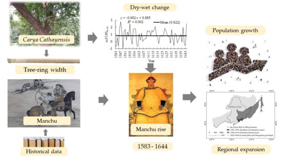
1. Introduction
2. Materials and Methods
2.1. Study Area
2.2. Tree-Ring Sampling
2.3. Chronology Development
2.4. Statistical Analysis
2.4.1. Reconstruction of scPDSI4–10
2.4.2. The Area, Shape, and Population of the Manchu Region of Control from 1583 to 1644
2.4.3. The Relationship Between Dry–Wet Change and the Manchu Rise
3. Results
3.1. Dry–Wet Change
3.1.1. Trend and Variability
3.1.2. Extreme Dry–Wet Change
3.2. Area and Population Changes in Manchu Region of Control
3.2.1. Expansion of Region of Control
3.2.2. The Complex Expansion of the Region of Control
3.2.3. The Population Growth in the Region of Control
3.3. The Relationship Between the Rise of the Manchu and Dry–Wet Change
3.3.1. The Relationship Between Territorial Expansion and Dry–Wet Variability
3.3.2. Relationship Between Territorial Shape and Dry–Wet Variability
3.3.3. The Relationship Between Population Growth in the Region of Control and Dry–Wet Variability
4. Discussion
4.1. Inconsistencies Between Regional Expansion and Dry–Wet Change
4.2. Inconsistencies Between the Shape of the Region and Dry–Wet Change
4.3. Inconsistencies Between Population Growth and Dry–Wet Change
4.4. Spatial Heterogeneity and Manchu’s Expanding Territory
4.5. The Impacts of Lower Temperatures
5. Conclusions
Author Contributions
Funding
Data Availability Statement
Acknowledgments
Conflicts of Interest
References
- Yang, L.S.; Feng, Q.; Adamowski, J.F.; Deo, R.C.; Yin, Z.L.; Wen, X.H.; Tang, X.; Wu, M. Causality of climate, food production and conflict over the last two millennia in the Hexi Corridor, China. Sci. Total Environ. 2020, 713, 136587. [Google Scholar] [CrossRef]
- Azong, M.N.; Kelso, C.J. Gender, ethnicity and vulnerability to climate change: The case of matrilineal and patrilineal societies in Bamenda Highlands Region, Cameroon. Glob. Environ. Change 2021, 67, 102241. [Google Scholar] [CrossRef]
- Chen, P.P.; Lu, P.; Tian, Y.; Li, Y.; Wang, H.; Zhang, J.Q.; Zhao, X.L.; Mo, D.W. The interplay between prehistoric vegetation, climatic fluctuations and anthropogenic activities in Central China. Catena 2024, 247, 108540. [Google Scholar] [CrossRef]
- Tan, N.Q.; Chuong, H.V.; Linh, N.H.K.; Tung, P.G.; Dinh, N.C.; Tuyet, T.T.A. Climate shocks and responses: Perspectives and experiences of ethnic minority farmers in rural mountainous regions of Central Vietnam. Heliyon 2023, 9, e15390. [Google Scholar] [CrossRef]
- Buonincontri, M.P.; Bosso, L.; Smeraldo, S.; Chiusano, M.L.; Pasta, S.; Di Pasquale, G. Shedding light on the effects of climate and anthropogenic pressures on the disappearance of Fagus sylvatica in the Italian lowlands: Evidence from archaeo-anthracology and spatial analyses. Sci. Total Environ. 2023, 877, 162893. [Google Scholar] [CrossRef]
- Adnan, M.; Xiao, B.H.; Bibi, S.; Xiao, P.W.; Zhao, P.; Wang, H.Y.; Ali, M.U.; An, X.J. Known and unknown environmental impacts related to climate changes in Pakistan: An under-recognized risk to local communities. Sustainability 2024, 16, 6108. [Google Scholar] [CrossRef]
- Chen, S.; Liu, Q.; Jia, Y.L.; Chen, X.X.; Wang, C.S.; Wang, Z.W.; Wan, Z.W.; Hong, Y.J.; Leng, X.; Wang, X.M.; et al. Spatial-temporal evolution of early history of north China (1600 BC-300 AD) and dynastic cycle driven by climate change. Acta Geogr. Sin. 2017, 72, 1580–1593, (In Chinese with English Abstract). [Google Scholar]
- Ding, W.G.; Yu, H.L.; Zhao, C.; Xu, H.; Chen, L.Z.; Xu, L. Impacts of historical socio-economic development policies on eco-environment in great Dunhuang region of China. Environ. Sci. Policy 2016, 55, 258–265. [Google Scholar] [CrossRef]
- Milman, A.; Arsano, Y. Climate adaptation and development: Contradictions for human security in Gambella, Ethiopia. Glob. Environ. Change 2014, 29, 349–359. [Google Scholar] [CrossRef]
- Tang, F.; Shi, Z.; Tian, Q.; Du, X.; Zhang, Y. The relationship between interannual dry/wet changes and nomadic wars in the Hexi Corridor region of China during the period 241–1912 A.D. Sci. China Earth Sci. 2024, 67, 1922–1931, (In Chinese with English Abstract). [Google Scholar] [CrossRef]
- Lin, L.K.; Gui, Y. Why does the courtyard spaces of same ethnic group present diverse characteristics in different regions: Evidence based on ENVI-met climate modelling. J. Clean. Prod. 2024, 466, 142703. [Google Scholar] [CrossRef]
- Prosekov, A.Y.; Ivanova, S.A. Nutritional features of indigenous people of Siberia and North America: Are we relatives? J. Ethnic Foods 2018, 5, 155–160. [Google Scholar] [CrossRef]
- Lai, H.K.; Lee, J.E.; Harrington, L.J.; Driscoll, A.A.; Newport, C.; Bolton, A.; Salter, C.; Morton, S.; Woodward, A.; Hales, S. Daily temperatures and child hospital admissions in Aotearoa New Zealand: Case time series analysis. Int. J. Environ. Res. Public Health 2024, 21, 1236. [Google Scholar] [CrossRef]
- Assaduzzaman, M.; Filatova, T.; Lovett, J.C.; Coenen, F.H.J.M. Gender-ethnicity intersectionality in climate change adaptation in the coastal areas of Bangladesh. Sustainability 2023, 15, 3744. [Google Scholar] [CrossRef]
- Tran, P.T.; Nguyen, T.Q.; Huynh, C.V.; Pham, T.H.; Schinkel, U. A nuanced analysis on livelihood resilience of Vietnamese upland households: An intersectional Lens of Ethnicity and Gender. Sustainability 2023, 15, 3510. [Google Scholar] [CrossRef]
- Manware, M.; Dubrow, R.; Carrion, D.; Ma, Y.Q.; Chen, K. Residential and race/ethnicity disparities in heat vulnerability in the United States. GeoHealth 2022, 6, 2022GH000695. [Google Scholar] [CrossRef]
- Ram, S. Tree growth–climate relationships of conifer trees and reconstruction of summer season Palmer Drought Severity Index (PDSI) at Pahalgam in Srinagar, India. Quat. Int. 2012, 254, 152–158. [Google Scholar] [CrossRef]
- Khan, A.; Chen, F.; Saleem, S.; Chen, Y.P.; Zhang, H.L.; Bakhtiyorov, Z. Tree-ring maximum latewood density reveals unprecedented warming and long-term summer temperature in the upper Indus Basin, northern Pakistan. Sci. Total Environ. 2024, 956, 177393. [Google Scholar] [CrossRef]
- Bakhtiyorov, Z.; Chen, F.; Chen, Y.P.; Wang, S.J.; Zhang, H.L.; Hu, M.; Yue, W.P.; Habibulloev, S.; Kavtaradze, G.; Gurskaya, M.; et al. Historical drivers and future streamflow variations of the Kura River in the Western Transcaucasia region of Georgia: Analysis of tree-ring chronologies from 1720 to 2021 CE. Palaeogeogr. Palaeoclimatol. Palaeoecol. 2024, 655, 112529. [Google Scholar] [CrossRef]
- Wang, X.D.; Song, Y.J.; An, Y.; Liu, X.H.; Li, X.Q. Dry-wet changes in a typical agriculture and pasture ecotone in China between 1540 and 2019. Int. J. Geo-Inf. 2024, 13, 191. [Google Scholar] [CrossRef]
- Wang, X.R.; Wang, Z.P.; Liu, M.X.; Zhang, D.Y.; Luo, T.R.; Li, X.Y.; Du, B.Y.; Qiu, Y.; Li, L.L.; Zhao, Y.R. Reconstruction of minimum may temperatures in Northeast China since 1797 AD based on tree ring width in Pinus Sylvestris var. mongolica. Forests 2024, 15, 2015. [Google Scholar] [CrossRef]
- Yu, J.; Chen, J.J.; Meng, S.W.; He, H.J.; Zhao, Y.S.; Zhang, P.; Yang, B.; Liu, Q.J. April to July precipitation reconstruction based on tree-ring width for the past 242 years in the northern Greater Khingan Mountains, Northeast China. Quat. Sci. 2024, 44, 895–907. (In Chinese) [Google Scholar]
- Liu, N.; Bao, G.; Bao, M. Response characteristics of chinese pine (Pinus tabulaeformis Carr) radial growth to climate and drought variability reconstruction in western Liaoning, Northeast China. Forests 2019, 10, 752. [Google Scholar] [CrossRef]
- Zhu, L.J.; Li, Z.S.; Zhang, Y.D.; Wang, X.C. A 211-year growing season temperature reconstruction using tree-ring width in Zhangguangcai Mountains, Northeast China: Linkages to the Pacific and Atlantic Oceans. Int. J. Climatol. 2017, 37, 3145–3153. [Google Scholar] [CrossRef]
- Wan, D.J.; Liu, J.P.; Ma, H.X. Temporal-spatial variation characteristics of utilization efficiency of water resources in Changbai Mountain area. Desalin. Water Treat. 2022, 276, 1–12. [Google Scholar] [CrossRef]
- Chang, S.; Huang, F.; He, H.S.; Liu, K.; Krohn, J. Impacts of snow cover seasonality on spring land surface phenology of forests in Changbai mountains of Northeast China. Sci. Total Environ. 2024, 927, 171965. [Google Scholar] [CrossRef]
- Liu, T.X.; Zhang, S.W.; Yu, L.X.; Bu, K.; Yang, J.C.; Chang, L.P. Simulation of regional temperature change effect of land cover change in agroforestry ecotone of Nenjiang River Basin in China. Theor. Appl. Climatol. 2017, 128, 971–981. [Google Scholar] [CrossRef]
- Hou, Y.W.; Mi, G.H.; Zhu, M.Y.; Chen, S.; Li, J.; Hao, Z.H.; Cai, D.Y.; Zhang, F.S. Carbon footprint of farming practices in farmland ecosystems on the North and Northeast China plains. J. Environ. Manag. 2024, 354, 120378. [Google Scholar] [CrossRef]
- Yang, Y.; Li, R.H.; Liu, H.; Wang, X.W. Spatiotemporal evolution and driving forces of habitat quality in agroforestry ecotone of Northeast China. Chin. J. Ecol. 2024, 43, 1399–1407, (In Chinese with English Abstract). [Google Scholar]
- Dong, Y.L.; Ren, Z.B.; Yao, F.; Ran, Y.; Sun, H.C.; He, X.Y. Land use/cover change and its policy implications in typical agriculture-forest ecotone of central Jilin province, China. Chin. Geogr. Sci. 2021, 31, 261–275. [Google Scholar] [CrossRef]
- Yang, Y.Q.; Zhang, M.M.; Yi, X.F. The effects of masting on rodent-mediated seed dispersal interaction of sympatric tree species. For. Ecol. Manag. 2019, 446, 126–134. [Google Scholar] [CrossRef]
- Velmex Inc. The Velmex “TA” System for Research and Non-Contact Measurement Analysis; Velmex Inc.: Bloomfield, NY, USA, 1992. [Google Scholar]
- Holmes, R. Computer Assisted Quality Control; Tree-ring Bulletin: AZ, USA, 1983. [Google Scholar]
- Cook, E.R. A Time Series Analysis Approach to Tree Ring Standardization; University of Arizona: Tucson, AZ, USA, 1985. [Google Scholar]
- Wilson, R.J.S.; Luckman, B.H. Tree-ring reconstruction of maximum and minimum temperatures and the diurnal temperature range in British Columbia, Canada. Dendrochronologia 2002, 20, 257–268. [Google Scholar] [CrossRef]
- Cook, E.R.; Kairiukstis, L.A. Methods of Dendrochronology: Applications in the Environmental Sciences; Kluwer Academic Publishers: Dordrecht, The Netherlands, 1990. [Google Scholar]
- Wigley, T.M.L.; Briffa, K.R.; Jones, P.D. On the average value of correlated time series, with applications in dendroclimatology and hydrometeorology. J. Clim. Appl. Meteorol. 1984, 23, 201–213. [Google Scholar] [CrossRef]
- Schrier, G.V.D.; Barichivich, J.; Briffa, K.R.; Jones, P.D. A scPDSI-based global data set of dry and wet spells for 1901–2009. J. Geophys. Res.-Atmos. 2013, 118, 4025–4048. [Google Scholar] [CrossRef]
- Sharifazari, S.; Palmer, J.G.; Johnson, F.; Turney, C.S.M.; Andersen, M.S. A multi-centennial drought reconstruction from tree-rings reveals a growing threat to Christmas Island’s water resources. Dendrochronologia 2024, 86, 126238. [Google Scholar] [CrossRef]
- Li, Z.S.; Liu, G.H.; Fu, B.J.; Zhang, Q.B.; Hu, C.J.; Luo, S.Z. Tree ring-based summer temperature reconstruction over the past 200 years in Miyaluo of western Sichuan, China. Quat. Sci. 2011, 31, 522–534. (In Chinese) [Google Scholar]
- Li, Z.S.; Liu, G.H.; Zhang, Q.B.; Hu, C.J.; Luo, S.Z.; Liu, X.L.; He, F. Tree ring reconstruction of summer temperature variations over the past 159 years in Wolong National Natural Reserve, western Sichuan, China. Chin. J. Plant Ecol. 2010, 34, 628–641. (In Chinese) [Google Scholar]
- Shah, S.K.; Bhattacharyya, A.; Chaudhary, V. Reconstruction of June–September precipitation based on tree-ring data of teak (Tectona grandis L.) from Hoshangabad, Madhya Pradesh, India. Dendrochronologia 2007, 25, 57–64. [Google Scholar] [CrossRef]
- Fan, Z.X.; Brauning, A.; Tian, Q.H.; Yang, B.; Cao, K.F. Tree ring recorded May–August temperature variations since A.D. 1585 in the Gaoligong Mountains, southeastern Tibetan Plateau. Palaeogeogr. Palaeoclimatol. Palaeoecol. 2010, 296, 94–102. [Google Scholar] [CrossRef]
- Zhou, L.; Chi, Y.G.; Li, Y. A multi-index evaluation of drought characteristics in China from 2001 to 2010. J. Zhejiang Norm. Univ. 2019, 42, 448–455, (In Chinese with English Abstract). [Google Scholar]
- Lv, F.Y.; Sun, Y.H.; Wang, X.Q.; Zhang, P.J. Precipitation changes and extreme drought events over the last millennium inferred from a pollen record from Moon Lake, Northeast China. Palaeogeogr. Palaeoclimatol. Palaeoecol. 2024, 640, 112089. [Google Scholar] [CrossRef]
- Han, D.X.; Gao, C.Y.; Yu, Z.C.; Yu, X.F.; Li, Y.H.; Cong, J.X.; Wang, G.P. Late Holocene vegetation and climate changes in the Great Hinggan Mountains, northeast China. Quat. Int. 2019, 532, 138–145. [Google Scholar] [CrossRef]
- Liu, Q.; Li, G.; Yang, X.J. The extreme drought event at the end of Ming Dynasty during 1637–1643 AD. J. Northwest Univ. (Nat. Sci. Ed.) 2014, 44, 833–837. (In Chinese) [Google Scholar]
- Yan, C.N. Nurhaci’s Biography (Enlarged Edition); Sino-Culture Press: Beijing, China, 2022. (In Chinese) [Google Scholar]
- Yan, C.N. The Great Enterprise; Zhonghua Book Company: Beijing, China, 2014. (In Chinese) [Google Scholar]
- Tan, Q.X. The Historical Atlas of China; Sinomap Press: Beijing, China, 1987. (In Chinese) [Google Scholar]
- Ma, J.F.; Wang, Y.T.; An, Y.; Zhang, M.; Wang, X.D. The impact of plant spatial patterns on nitrogen removal in the Naolihe wetlands of Northeast China. Water 2024, 16, 128. [Google Scholar] [CrossRef]
- Yu, H.; Wang, X.D.; Chu, L.J.; Wang, G.D.; Sun, G.Z.; Sun, M.Y.; Wang, J.Y.; Jiang, M. Is there any correlation between landscape characteristics and total nitrogen in wetlands receiving agricultural drainages? Chin. Geogr. Sci. 2019, 29, 712–724. [Google Scholar] [CrossRef]
- Song, L.L.; Zhang, Q.; Ren, Y.L.; Li, Y.P.; Han, L.Y.; Liu, Y.P.; Wang, S.P. The applicable analysis of PDSI and self-calibrating PDSI drought indices in southwest China. J. Desert Res. 2021, 41, 242–251, (In Chinese with English Abstract). [Google Scholar]
- Shi, H.; Peng, X.; Zhou, Y.J.; Wang, A.Y.; Sun, X.K.; Li, N.; Bao, Q.S.; Buri, G.; Hao, G.Y. Resilience and response: Unveiling the impacts of extreme droughts on forests through integrated dendrochronological and remote sensing analyses. For. Ecosyst. 2024, 11, 491–501. [Google Scholar] [CrossRef]
- Hao, W.J. A Study of the League-banner system and the social changes in Inner Mongolia in the Qing dynasty. J. Jilin Norm. Univ. (Humanit. Soc. Sci. Ed.) 2022, 50, 10–18. (In Chinese) [Google Scholar]
- Kudrina, P.I.; Bogolepova, A.N.; Ariev, A.L. Ethnic features of multipathology in elderly and senile patients of the Republic of Sakha suffering from chronic brain ischemia. Zhurnal Nevrol. i Psikhiatrii Im. SS Korsakova 2023, 123, 50–54. [Google Scholar] [CrossRef]
- Shi, Q. Policy change of the Northeast frontier in the Late Ming Dynasty. J. Harbin Univ. 2019, 40, 82–86. (In Chinese) [Google Scholar]
- Liu, Y.Q. The commercial nature of the Eight Banners organization before the Qing Dynasty entered the country. J. Chin. Soc. Econ. Hist. 2022, 2, 39–49. [Google Scholar]
- Zhang, X.M. Jianzhou Jurchen during the political change of Northeast Asian in the late Ming dynasty-centered on the Renchen War period. J. Anshan Norm. Univ. 2018, 20, 25–29, (In Chinese with English Abstract). [Google Scholar]
- Li, J. From border town to Shengjing: Administrative division and management strategy changes in Liaodong during the Ming and Qing dynasties. China’s Borderl. Hist. Geogr. Stud. 2022, 32, 82–90, (In Chinese with English Abstract). [Google Scholar]
- Zhou, X.F. the indigenous peoples in Heilongjiang province during the Late Ming Dynasty. Northeast. Hist. Geogr. 2008, 5, 77–82. (In Chinese) [Google Scholar]
- Bennett, J.S. Retrodicting the rise, spread, and fall of large-scale states in the Old World. PLoS ONE 2022, 17, e0261816. [Google Scholar] [CrossRef]
- Zhang, J.M. On Manchu and Changbai mountain. Manchu Stud. 2019, 2, 117–124, (In Chinese with English Abstract). [Google Scholar]
- Meng, F.Y. The concept of national unity of the Qing dynasty and the construction of the administrative system of the northeast borderlands of China. J. Yunnan Norm. Univ. (Humanit. Soc. Sci. Ed.) 2015, 47, 10–19, (In Chinese with English Abstract). [Google Scholar]
- Zhang, Y.Q.; Shao, C.L.; Chen, J.Q.; Lu, G.J. Understanding 3000 years of nomadic history of Mongolian Grassland: Grassland, livestock and population. J. Arid. Land Resour. Environ. 2019, 33, 40–45. (In Chinese) [Google Scholar]
- Fang, L.; Su, A.L. Natural disasters and population changes in the Huaihe river basin in modern times. J. Catastrophol. 2022, 37, 47–51. [Google Scholar]
- Zhu, X.Y.; Zhu, S.L. On the changes of Maize planting in the middle and lower reaches of Liaohe river since the Qing dynasty. Agric. Archaeol. 2023, 3, 68–77, (In Chinese with English Abstract). [Google Scholar]
- Fang, X.Q.; Xiao, L.B.; Su, Y.; Zheng, J.Y.; Wei, Z.D.; Yin, J. Social impacts of climate change on the history of China. J. Palaeogeogr. 2017, 19, 729–736, (In Chinese with English Abstract). [Google Scholar]
- Guo, Y.; Fang, X.Q.; Ye, Y. River freeze-up date anomalies during the sixteenth to nineteenth centuries in southern Northeast China reconstructed from the Korean Envoys Yanxing Book. Clim. Change 2023, 177, 3. [Google Scholar] [CrossRef]
- Wang, B.N. The abrupt climate change and the change in Shandong’s farming system in the late Ming dynasty-discussion on the two year three maturity system in North China. Agric. Archaeol. 2014, 4, 6–15. (In Chinese) [Google Scholar]
- Jiang, B. The rise and fall of the Jurchen society and economy in Northeast China during the late Ming and early Qing dynasties. J. Soc. Sci. Harbin Norm. Univ. 2024, 4, 139–142. (In Chinese) [Google Scholar]
- Tian, Y. Analysis on population policy and migration trend of Liaoning province in late Ming and early Qing dynasty. J. Jiamusi Vocat. Inst. 2018, 3, 96–98. (In Chinese) [Google Scholar]


| Plot | Longitude (E) | Latitude (N) | C/T | NCC | RP (Year) |
|---|---|---|---|---|---|
| 1 | 126.9268 | 44.34423 | 20/10 | 16 | 1417–2022 |
| 2 | 126.0523 | 44.06951 | 16/8 | 12 | 1443–2022 |
| 3 | 125.7393 | 43.53871 | 23/13 | 21 | 1419–2022 |
| 4 | 124.9945 | 43.46301 | 22/12 | 18 | 1457–2022 |
| r | R2 | R2adj | RE | ST | PMT | DW | |
|---|---|---|---|---|---|---|---|
| Calibration | 0.76 ** | 0.576 | 0.569 | ||||
| Verification | 0.76 ** | 0.576 | 0.569 | 0.432 | 60+/62− * | 3.744 * | 1.810 |
| Dry or Wet Conditions | scPDSI4–10 Range | Number of Occurrences (Year) | Proportion (%) |
|---|---|---|---|
| Moderately wet | 2–3 | 3 | 4.839 |
| Slightly wet | 1–2 | 25 | 40.323 |
| Normal | −1–1 | 34 | 54.839 |
| Positive Direction | Negative Direction | ||||||
|---|---|---|---|---|---|---|---|
| Turn | Excluded Year | ER | p | Turn | Excluded Year | ER | p |
| 1 | 1583 | −0.14 | 0.271 | 1 | 1584 | −0.22 | 0.087 |
| 2 | 1589 | −0.11 | 0.405 | 2 | 1607 | −0.25 | 0.048 |
| 3 | 1617 | −0.07 | 0.583 | 3 | 1629 | −0.29 | 0.026 |
| 4 | 1616 | −0.03 | 0.829 | 4 | 1592 | −0.33 | 0.013 |
| 5 | 1628 | −0.01 | 0.930 | 5 | 1644 | −0.36 | 0.006 |
| 6 | 1594 | 0.05 | 0.711 | ||||
| 7 | 1587 | 0.09 | 0.506 | ||||
| 8 | 1610 | 0.12 | 0.370 | ||||
| 9 | 1585 | 0.17 | 0.263 | ||||
| 10 | 1618 | 0.19 | 0.184 | ||||
| 11 | 1624 | 0.22 | 0.124 | ||||
| 12 | 1625 | 0.25 | 0.081 | ||||
| 13 | 1621 | 0.28 | 0.053 | ||||
| 14 | 1586 | 0.31 | 0.035 | ||||
| 15 | 1593 | 0.33 | 0.022 | ||||
| 16 | 1641 | 0.36 | 0.015 | ||||
| 17 | 1611 | 0.38 | 0.010 | ||||
| 18 | 1612 | 0.41 | 0.006 | ||||
| Positive Direction | Negative Direction | ||||||
|---|---|---|---|---|---|---|---|
| Turn | Excluded Year | ER | p | Turn | Excluded Year | ER | p |
| 1 | 1617 | −0.14 | 0.276 | 1 | 1584 | −0.26 | 0.042 |
| 2 | 1624 | −0.07 | 0.622 | 2 | 1592 | −0.29 | 0.023 |
| 3 | 1587 | 0.02 | 0.897 | 3 | 1609 | −0.31 | 0.017 |
| 4 | 1585 | 0.06 | 0.661 | 4 | 1631 | −0.32 | 0.013 |
| 5 | 1583 | 0.11 | 0.429 | 5 | 1595 | −0.34 | 0.011 |
| 6 | 1586 | 0.15 | 0.256 | 6 | 1644 | −0.35 | 0.007 |
| 7 | 1594 | 0.18 | 0.198 | 7 | |||
| 8 | 1632 | 0.20 | 0.149 | 8 | |||
| 9 | 1619 | 0.22 | 0.110 | 9 | |||
| 10 | 1644 | 0.25 | 0.079 | 10 | |||
| 11 | 1588 | 0.27 | 0.052 | 11 | |||
| 12 | 1595 | 0.30 | 0.033 | 12 | |||
| 13 | 1589 | 0.34 | 0.019 | 13 | |||
| 14 | 1600 | 0.37 | 0.010 | 14 | |||
| 15 | 1593 | 0.40 | 0.005 | 15 | |||
| Positive Direction | Negative Direction | ||||||
|---|---|---|---|---|---|---|---|
| Turn | Excluded Year | ER | p | Turn | Excluded Year | ER | p |
| 1 | 1599 | 0.16 | 0.220 | 1 | 1621 | 0.03 | 0.826 |
| 2 | 1620 | 0.21 | 0.106 | 2 | 1587 | 0.00 | 0.970 |
| 3 | 1612 | 0.24 | 0.069 | 3 | 1613 | −0.02 | 0.881 |
| 4 | 1643 | 0.27 | 0.042 | 4 | 1644 | −0.04 | 0.738 |
| 5 | 1594 | 0.29 | 0.030 | 5 | 1595 | −0.07 | 0.591 |
| 6 | 1632 | 0.31 | 0.020 | 6 | 1617 | −0.10 | 0.481 |
| 7 | 1638 | 0.33 | 0.014 | 7 | 1639 | −0.12 | 0.388 |
| 8 | 1584 | 0.35 | 0.009 | 8 | 1641 | −0.14 | 0.324 |
| 9 | 1589 | −0.16 | 0.264 | ||||
| 10 | 1598 | −0.18 | 0.214 | ||||
| 11 | 1625 | −0.20 | 0.170 | ||||
| 12 | 1600 | −0.22 | 0.130 | ||||
| 13 | 1583 | −0.24 | 0.097 | ||||
| 14 | 1591 | −0.26 | 0.069 | ||||
| 15 | 1602 | −0.29 | 0.046 | ||||
| 16 | 1616 | −0.32 | 0.030 | ||||
| 17 | 1586 | −0.35 | 0.018 | ||||
| 18 | 1585 | −0.38 | 0.010 | ||||
| 19 | 1614 | −0.41 | 0.006 | ||||
Disclaimer/Publisher’s Note: The statements, opinions and data contained in all publications are solely those of the individual author(s) and contributor(s) and not of MDPI and/or the editor(s). MDPI and/or the editor(s) disclaim responsibility for any injury to people or property resulting from any ideas, methods, instructions or products referred to in the content. |
© 2025 by the authors. Licensee MDPI, Basel, Switzerland. This article is an open access article distributed under the terms and conditions of the Creative Commons Attribution (CC BY) license (https://creativecommons.org/licenses/by/4.0/).
Share and Cite
Wang, X.; Xu, X.; Fei, L.; Liu, X.; Yang, L. The Relationship Between Dry–Wet Change and the Manchu Rise in China. Quaternary 2025, 8, 61. https://doi.org/10.3390/quat8040061
Wang X, Xu X, Fei L, Liu X, Yang L. The Relationship Between Dry–Wet Change and the Manchu Rise in China. Quaternary. 2025; 8(4):61. https://doi.org/10.3390/quat8040061
Chicago/Turabian StyleWang, Xiaodong, Xiaoyun Xu, Long Fei, Xiaohui Liu, and Lijie Yang. 2025. "The Relationship Between Dry–Wet Change and the Manchu Rise in China" Quaternary 8, no. 4: 61. https://doi.org/10.3390/quat8040061
APA StyleWang, X., Xu, X., Fei, L., Liu, X., & Yang, L. (2025). The Relationship Between Dry–Wet Change and the Manchu Rise in China. Quaternary, 8(4), 61. https://doi.org/10.3390/quat8040061