Review

Exploring Early Human Presence in West Central Africa’s Rainforests: Archeo-Paleontological Surveys, Taphonomy, and Insights from Living Primates in Equatorial Guinea

by
Antonio Rosas
1,*,
Antonio Garcia-Tabernero
1,2,
Darío Fidalgo
1,
Juan Ignacio Morales
3,
Palmira Saladié
3,4,5,
Maximiliano Fero Meñe
6 and
Cayetano Ebana Ebana
7
1
Grupo de Paleoantropología, Departamento de Paleobiología, Museo Nacional de Ciencias Naturales (CSIC), 28006 Madrid, Spain
2
Área de Antropología Física, Facultad de C. Biológicas y Ambientales, Universidad de León, 24071 León, Spain
3
Institut Català de Paleoecologia Humana i Evolució Social (IPHES), 43007 Tarragona, Spain
4
Unidad Asociada al CSIC, Departamento de Paleobiología, Museo Nacional de Ciencias Naturales, 28006 Madrid, Spain
5
Departament de Història i Història de l’Art. Avinguda de Catalunya 35, Universitat Rovira i Virgili, 43001 Tarragona, Spain
6
Oficina de Investigación, Universidad Nacional de Guinea Ecuatorial (UNGE), Malabo 661, Equatorial Guinea
7
Instituto Nacional de Desarrollo Forestal y Manejo del Sistema de Áreas Protegidas (INDEFOR-AP), Bata 207, Equatorial Guinea
*
Author to whom correspondence should be addressed.
Quaternary 2025, 8(3), 45; https://doi.org/10.3390/quat8030045
Submission received: 25 April 2025 / Revised: 30 July 2025 / Accepted: 31 July 2025 / Published: 5 August 2025

Abstract

Since 2014, the Paleoanthropology Group of the National Museum of Natural Sciences (CSIC), in collaboration with Equatoguinean researchers, has been conducting archeo-paleontological fieldwork in Equatorial Guinea, continuing a longstanding Spanish naturalist tradition in this region of West Central Africa. These multidisciplinary investigations, framed within an archeo-paleo-anthropological approach, aim primarily to identify early human occupation in the Central African rainforests. To date, robust evidence of Pleistocene human presence has been documented, particularly through lithic assemblages. Although the scarcity and fragmentation of well-dated sites in Central Africa complicate chronological placement, technological traits observed in the lithic industries recorded in Equatorial Guinea show clear affinities with the African Middle Stone Age (MSA). Complementary taphonomic analyses of faunal remains have been undertaken to better understand bone preservation and fossilization processes under tropical rainforest conditions, thereby contributing to the interpretation of archeological contexts. In parallel, ongoing primatological research within the project—focused on extant primates in their natural habitats—seeks to provide ethological models relevant to the study of hominin locomotor evolution. Notably, the project has led to the ecogeographic characterization of the Engong chimpanzee group in Monte Alén National Park, one of the country’s most pristine protected areas.

1. Introduction

Although the African continent is known to be the cradle of humankind, the sources of information available to us—sites with human remains and archaeological evidence—are unevenly distributed, with the vast majority of finds accumulating in the southern and eastern fringes (especially around the Rift Valley) and North Africa [1]. Given the sheer size of the African continent, this distribution gives a necessarily partial picture of the evolutionary landscape of the human lineage, with vast regions devoid of archeo-palaeontological records. Indeed, the entire vast central part of the continent can be considered a paleontological desert, with the rare exceptions of the Iwo Eleru skull in Nigeria [2] or the Ishango remains in the Democratic Republic of Congo [3]. Especially the Central African rainforests (tropical and subtropical moist broadleaf forests = TSMF) have not been widely explored from an archeo-paleontological point of view, either because of the inherent difficulty of conducting prospecting and/or excavation campaigns, or because of the traditional assumption of the absence of fossils in these environments, making them apparently not very conducive to preservation and fossilization [4]. It remains to be determined whether these absences are really due to the latter or to the fact that they have not been sampled as extensively as they have been in other more favorable environments on the continent such as savannahs, open arid areas, deserts, etc.
On the other hand, it is in this type of environment, the Central African rainforests, where, ex hypothesi, the last common ancestor (LCA) of the lineages that will give rise to chimpanzees and humans [5], from which bipedalism will emerge, has its origin. The potential habitat of this LCA is well represented in Equatorial Guinea (EG), where there are still some protected areas that preserve primary forests potentially similar to those where bipedal locomotion would have arisen [6]. Darwin alluded in his work The Origin of Man to what is known as the Law of Paleontological Succession, which can be summarized as follows: the ancestors of species are usually found in the same geographical location where the descendant species live today. While there are many exceptions to this generality [7], it was this principle that led Darwin to place human origins in Africa rather than Asia or Europe. Making this principle of the Law of Succession more restrictive, we see that the species most closely related to ours, chimpanzees and gorillas, live in the rainforest belt, so it is a reasonable hypothesis to predict that the common ancestor of all these species must have lived in this same area.
It is from this general scientific overview that the Paleoanthropology Group of the Museo Nacional de Ciencias Naturales (CSIC) proposes the project it has been developing for 10 years in Equatorial Guinea, called ‘Archaeo-palaeontological surveys in Equatorial Guinea’ [8,9,10]. Under the auspices of various Spanish and Equatoguinean institutions, eleven field campaigns have been carried out in the insular and continental territories of Equatorial Guinea that have allowed for a much greater understanding of the general archeo-paleontological context of the country [11,12]. Specifically, during this time, work has been carried out from two complementary points of view: an archeo-paleontological approach in the strict sense, focused on the contextualization and study of the fossil and archeological record, and an actualistic approach that seeks the analysis of current references of natural processes that allow for inferences from the past to be made. The various disciplines and methodologies contemplated in the development of the project include geological studies, comprehensive archeo-paleontological surveys, the study of archeological sites and the analysis of their records, the characterization of taphonomic processes, the drawing of ecological inferences and the monitoring of primates, among others. This article reviews in detail the different studies carried out within this project, presenting and discussing the main results derived from this holistic approach.

2. Archeo-Paleontological Aspects

2.1. Geological Context of the Archeo-Paleontological Record

In the 10 years of work in Equatorial Guinea, one of the priorities has been the exhaustive documentation of the archeo-paleontological context of the entire Equatoguinean territory. This documentation is based on the few geological maps published [13,14,15] and mainly on in situ analyses of eluvial and stratigraphic outcrops potentially containing archeo-paleontological materials. In this sense, geological surveys have been crucial for the elaboration of new schemes aimed at understanding the Quaternary contexts of Equatorial Guinea (Figure 1). In parallel to the field documentation work, rock and sediment sampling has been carried out for the detailed geological and physico-chemical characterization of the deposits.
The fieldwork has mainly focused on three main types of sedimentary deposits present in the geological maps of Equatorial Guinea, with special paleoanthropological interest (derived from their potential chronology):
(a)
The basins (semigrabens) with Miocene sediments generated in events of high tectonic activity and located following faults in the eastern half of the country, with an east–west orientation [16,17] (Figure 1). Unfortunately, we have found that the alteration processes of all sedimentary deposits below the vegetation cover lead to a homogenization of the materials and destruction of the stratigraphic organization. In fact, it has not been possible to clearly delimit any of the semigrabens indicated in the geological maps, and it seems extremely unlikely that a Miocene fossil record is preserved throughout Equatorial Guinea.
(b)
Quaternary sediments deposited in coastal, fluvial, and lacustrine environments. The characterization of this type of depositional environments has allowed for the location of sedimentary singularities which, in some cases, have allowed for the recovery of archaeological records [18]. This is the case of the fluvial and deltaic environment sites in the Río Campo area, associated with different migration phases of the Ntem River [19,20]. In turn, discoveries of paleolacustrine deposits in an ancient maar located on the west coast of Bioko Island [21,22] and intramontane basins located in the heart of the Monte Alén Nature Reserve present great future potential for paleoclimatic studies.
(c)
Eluvial materials resulting from the in situ decomposition of the basal rocks that give rise to alteration profiles. Many of these profiles end up forming structures grouped under the generic and not very specific term of stone lines. It is not uncommon to find more or less dispersed pieces of lithic industry in these profiles [23,24]; a phenomenon already detected by Mercader [25]. In this context, attention has been paid to the complex processes of formation of these ‘stone lines’, a phenomenon widely mentioned in the field of geology and archeology in Africa. These phenomena are in some cases associated with purely geological processes, while in some other contexts they may themselves form archeological sites that are difficult to explain taphonomically. Stone lines present different morphologies, which points to a wide variety of formative processes, among which allochthonous processes (coarse materials have undergone transport) and autochthonous processes (without transport, whose formation is in situ) can be distinguished. In our fieldwork we have been able to distinguish four different morphotypes of stonelines, according to their morphology, arrangement, and composition [19]: (1) the so-called ferruginous nodular horizons (rounded hematite nodules); (2) accumulations of tabular hematitic nodules; (3) quartz lines or veins; (4) the combination of hematitic nodules with other types of clasts, among which lithic tools can be found. It is precisely this last model of stone lines that is of most archeological interest, and, up to now, its interpretation has been proposed as interruptions in sedimentation, marked by a subaerial exposure and a loss of vegetation cover in times of aridification throughout the Quaternary [26], a similar process to that alluded to by Mercader et al. [27] to explain the recurrent presence of the lithic industry in this type of formation. If this interpretation is true, a good part of the stratigraphic sections exposed in Equatorial Guinea would reveal accentuated erosion processes in very recent geological moments possibly related to abrupt climatic changes.

2.2. Archeo-Paleontological Surveys

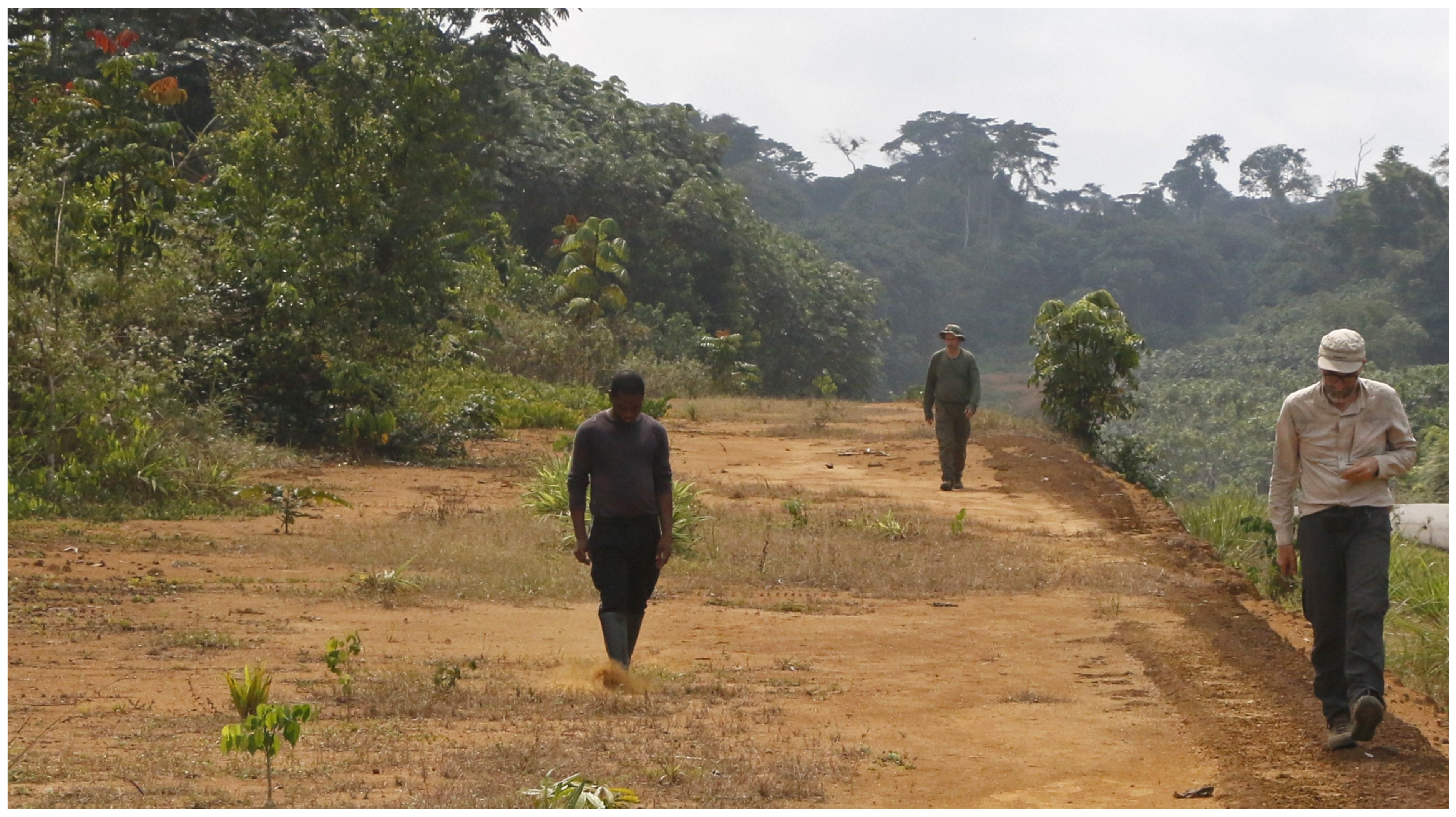
After identifying on the geological maps those places with sedimentary deposits of an age and formation conditions favorable to the potential preservation of fossils and/or archeological materials, systematic prospecting campaigns have been planned in the selected areas [18,21]. The areas free of a vegetation cover that allows for sampling correspond to road cuttings and slopes, forest tracks, quarries, etc. (Figure 2). Of special interest are estuarine areas and river mouths for their potential deposits of sedimentary material. UTM coordinates have been taken for each point of interest and daily routes have been recorded. They have been thoroughly documented by means of photographs and field notes, stratigraphic columns, and diagrams. Each site with stratigraphic and/or eluvial outcrops of special interest, as well as those where archeo-paleontological material is collected, have been numbered with the notation ‘Point no. x’ and the corresponding successive number. The routes and points taken have been projected on cartography, especially geological and topographical (Figure 1).
In the course of the 11 field campaigns, the entire area of Bioko Island and a large part of the mainland were surveyed. In total 450 points were noted (Figure 1), and more than 800 pieces of lithic industry were collected.

2.3. Contextualization of Archeological Sites

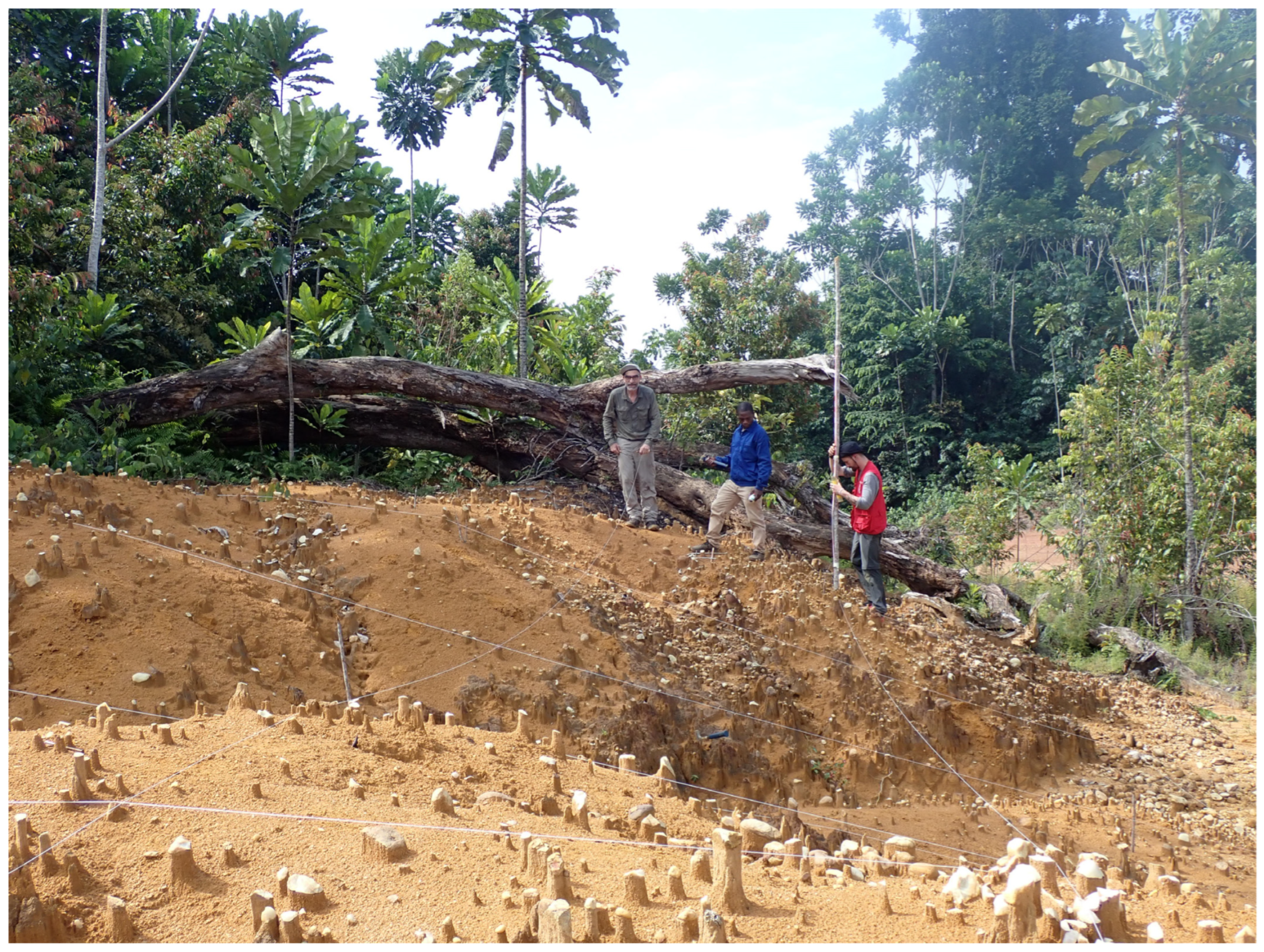
A total of 50 localities with archeological materials, mainly the lithic industry, have been documented in detail. In all these localities, intensive sampling of lithic tools located on the surface has been carried out [28]. It is worth mentioning the particularly abundant archeological record found at the sites of Campo 11 and Temelón 50, which was collected on the surface and by stratigraphic and archeological probing, preserving the data on the spatial disposition of the record. Both sites will be the subject of specific future work [20] (Figure 3). However, despite our efforts to locate Mio-Plio-Quaternary fossil remains, we have not found any paleontological sites.
One of the most relevant aspects, although less developed in the archeological record of the Gulf of Guinea, is obtaining radiometric dating of archeological levels or materials. In our project we devoted special effort to the collection of samples for radiocarbon and OSL (Optically Stimulated Luminescence) analysis. The chronologies obtained so far point to a relatively recent Quaternary sedimentary record that does not exceed the Upper Pleistocene in age.
As part of our project, chronometric analyses were carried out on four distinct Quaternary outcrops in the Río Campo area [10]. The most significant of these is Campo 5, characterized by a deep, fluvially deposited sediment sequence—up to 5 m thick—within a basin-like topography. OSL dating of samples from its basal, middle, and upper layers yielded ages of 76.0, 44.0, and 21.7 ka, respectively [10]. The basal level, thus, represents the oldest dated Quaternary sediments in Equatorial Guinea, at 76.0 ± 8.5 ka. However, this chronological framework remains provisional, as other outcrops may yield similar or older dates—making this a minimum age estimate.
Additional coastal outcrops in the same region were also dated: Campo 4 yielded 24.0 ± 1.9 ka BP; Campo 11 returned ages ranging from 23.2 ± 2.4 to 20.6 ± 1.4 ka BP, with a radiocarbon sample indicating >43.5 ka BP. Campo 30 produced an OSL age of 6.2 ± 0.4 ka BP, and Campo 13-1 a radiocarbon date of 2.38 ± 0.03 ka BP. Radiocarbon calibrations were performed using BetaCal4.20: HPD and the INTCAL20 curve.
These data would point to sedimentary and taphonomic processes very unfavorable to the preservation of the materials, which could represent a permanent bias for the knowledge of the ancient prehistory of West Africa.

2.4. Study of the Archeological Record and Materials

Given the specific characteristics of the different territories surveyed, the fieldwork has been differentiated between the island territory of Bioko (formerly the island of Fernando Poo) and the mainland region of the country, also known as Rio Muni.
The beginning of human settlement on the island of Bioko is still poorly understood. Previous research established an exclusively Holocene sequence of occupation [29,30,31], although Bioko has been connected to the mainland at least during the last glacial period [19]. In order to locate evidence of Pleistocene occupation, 44 points/outcrops were georeferenced, distinguishing volcanic sediments and eluvial and volcano-sedimentary materials (Figure 1). Among the latter, a large series of lacustrine sediments corresponding to a paleolake located in a crater (maar) [21] was found. Despite the thoroughness of the surveys, no evidence of human presence attributable to a Pleistocene chronology was found. Our results confirm a very late occupation of Bioko after 8000 years BP. The absence of previous occupations could be due to hostile ecological conditions (rainfall, parasitism), although it is possible that Pleistocene occupations were restricted to coastal areas and that these are now submerged.
Surveys in the mainland region have documented abundant localities with Paleolithic archeological record distributed throughout the territory, including the areas of Bata, Evinayon, Monte Alén, Mosumu, and the Rio Muni estuary. However, the highest density of finds is clearly associated with the Campo river basin, where 16 sites have been located. In total, 418 pieces of lithic industry have been recovered, which represents 48% of the total sample recovered up to the 2024 campaign.
The recognition and visibility of archeological materials in settlements within the rainforest is largely stochastic and highly dependent on both natural and anthropogenic erosional processes that may have cleared the thick vegetation and soil cover, so that subsequent field surveys may change the current perspective of some of these locations. Based on the patterns of aggregation, the variability of raw materials within each location, and the structural composition of the associations, the data recovered as a whole has allowed us to establish a first classification into at least three types of locations displaying archeological record. This classification, however, does not attempt to define ‘type sites’ from a paleo-ethnographic point of view, but rather to provide clear descriptive categories. From this perspective, the 16 locations of the Campo River stand out, which, in this work, we take as a reference of the total number of locations detected in the continental region of GE.
The locations or points in the Río Campo region can be classified into three categories: (1) isolated points (n = 8), (2) associations of tools (n = 6), and (3) complex accumulations (n = 2). Isolated points are characterized by the occurrence of isolated lithic pieces or in very low numbers, in groups of pieces without any apparent contextual association to any element of the landscape, neither geomorphological nor anthropic. Some of them represent possible areas of ephemeral activity in which some tools or flakes were abandoned, and there are quite illustrative examples of this pattern. In the case of Campo 42, a bifacial point was discarded after breaking probably during manufacture or rejuvenation; and in Campo 10, an isolated Levallois-type prepared core was abandoned after the detachment of a large preferential flake.
Tool assemblages represent either small (n = 3) to moderate (n = 18) accumulations of lithic remains that show some kind of internal coherence and/or association features such as clusters of raw materials or internal technological consistency. In a sense, these tool assemblages are understood as areas of restricted activity in a similar sense to that given to such accumulations when found in open environments characteristic of arid and semi-arid regions. These sites can often be interpreted as carving areas and are characterized by the presence of flakes and cores. Campo 3 is probably the clearest example of this pattern represented by the association of a bipolar quartzite core on anvil and several flakes and flake fragments of this material. Similarly, Campo 5 is represented by a very small Levallois-type prepared core discarded after the accumulation of abundant stepped negatives, a small sequence of bipolar reduction-on-anvil bipolar flakes on quartzite and a very small independent core of bipolar quartzite on anvil.
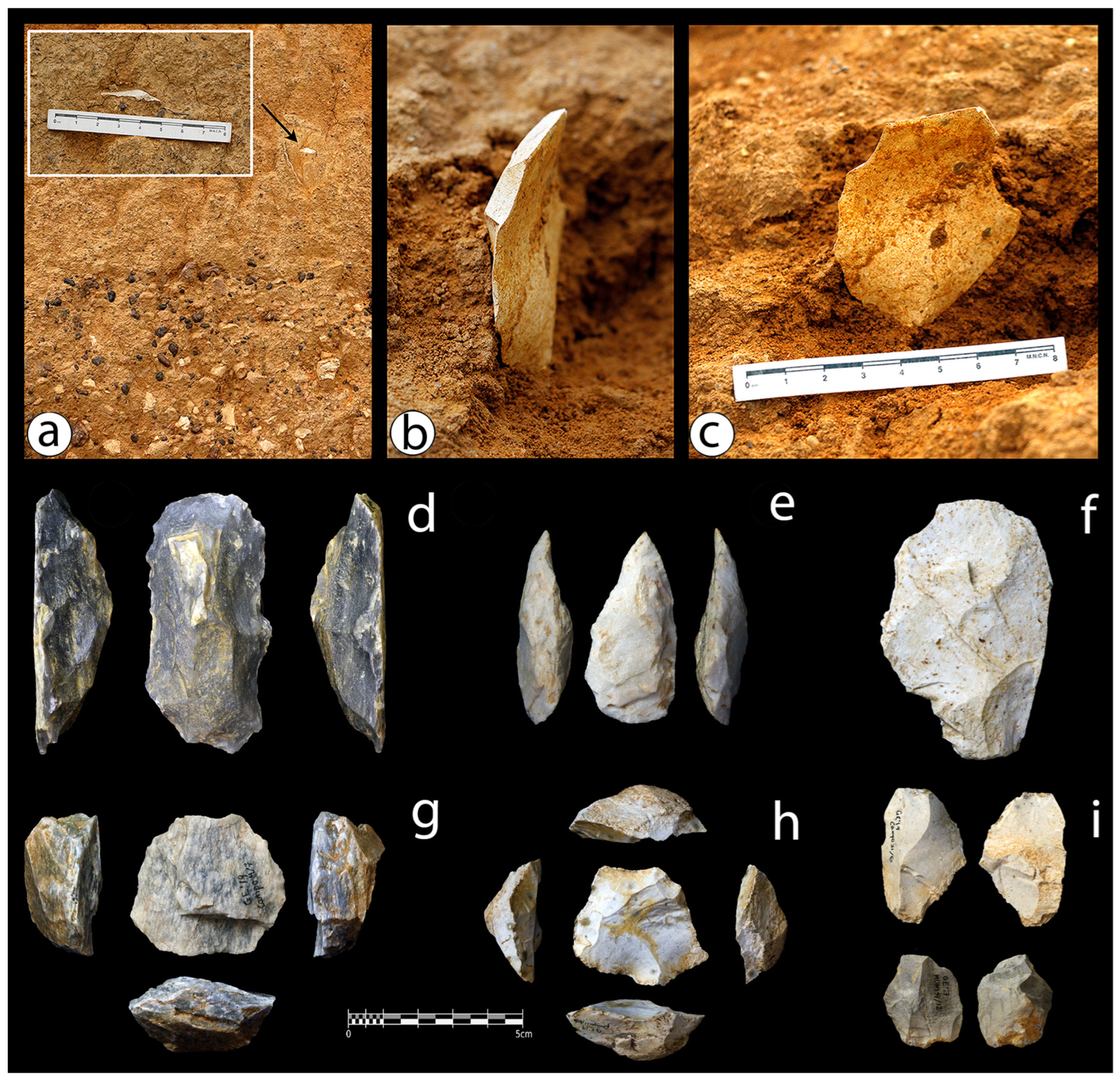
Finally, complex accumulations define larger aggregations of lithic assemblages that show both coherence in terms of degree of preservation, raw material representation, and technological structure. The associations of tools with these features can be understood as areas of intense occupation and represent the closest image to the concept of an archeological site with a spatial delimitation. The most significant sites found up to the 2024 field season are Campo 4 (n = 65) and especially Campo 11 (n = 288) (see Figure 4), classified as complex accumulations. Both sites have provided the highest density of lithic remains, the most structured and diversified assemblages, and represent complex accumulations probably derived from the exposure or dismantling of ancient habitation areas on the banks of the Campo river. Campo 11 evidences a diversified technological structure with several independent reduction strategies such as Levallois or laminar, among others, including cores in different stages of reduction and the greatest diversity of retouched tools. There is also evidence of in situ tool manufacture, as could be the case of bifacial points and fire-cracked tools that point to a domestic context.
It is also noteworthy that no examples of microlaminar reduction strategies, microlithic and geometric tools or arrowheads defining the Tshitollian [32] have been recovered throughout the Rio Campo basin, but neither in any other area of Equatorial Guinea during our surveys.

3. Río Campo in Context

The scarcity and temporal dispersion of Paleolithic sites in Central Africa works against the placement of the Rio Campo assemblages within existing reference frameworks. However, several technological traits prevalent in the technological structure documented here allow us to propose a clear MSA affinity of most of the Rio Campo assemblages. In parallel, no diagnostic features pointing to pre-MSA occupations have been found. On the contrary, abundant Iron Age wares were observed during the survey and a charcoal sample associated with some of these materials was dated to the 3rd millennium cal BP.
The Campo 11 site outlines a diversified technological structure characterized by the co-occurrence of multiple reduction strategies such as prepared cores, flake production, bipolar cores on anvil, or naviform cores. This heterogeneity in flake production strategies contrasts with the scarce presence and variability of retouched tools. The overview of the techno-typological features documented across the Río Campo sites also outlines a fairly homogeneous technological structure both intra- and inter-locality. All the recognizable features documented in the different localities are present in the Campo 11 assemblage, outlining a diversified technological scheme dominated by prepared core technologies, heavy axes and wedges, and bifacial lanceolate points. This techno-typological structure clearly points to the prevalent MSA origin of the Río Campo technological record and fits with the regional Lupemban MSA tradition as accurately described elsewhere [33,34,35].
A significant feature of the Campo sites is the systematic occurrence of heavy tools that show clear evidence axe/adze functions or even their use as intermediate tools. Functional interpretations require additional microscopic observation and experimental work, but these artefacts appear to group with the smaller flaked wedges in a tool assemblage related to specific heavy-duty tasks traditionally assumed to be woodworking [36]. Discerning whether this tool assemblage is in part reminiscent of Mode 2 or an independent adaptation to woodland environments requires further research. Heavy work items have traditionally been defined as a technological marker of Sangoan-Lupemban assemblages across the rainforests and woodlands of central Africa [33]. Their presence has been attested in MSA assemblages in areas that show preceding Acheulean occupations, such as Kalambo Falls in eastern Zambia [37,38,39,40], or the Nilotic site 8-B-11 on the Sudanese island of Sai [41,42,43], but also in the interior of the Congo Basin, where no evidence of Mode 2 settlement has yet been documented [33].
The closest MSA evidence to the Río Campo assemblages are the Mosumu stone lines (EG) [27,44]. The Mosumu collection [45] shares attributes with Campo 11, such as the presence of prepared cores and the prevalence of bifacial points and small- to medium-sized core-axes but diverges in the widespread presence of a heavy component. There is also convergence in the small size of bifacial points, which contrasts with the larger specimens up to 40 cm long recorded at the forest/savanna boundaries [33].
Mercader et al. [27] also refer to an LSA assemblage covering the Mosumu MSA lithic lineage characterized by the presence of single platform cores or ‘small-sized tools’. However, there is a total absence of microliths or bladelet technologies [27], and this technological structure has been documented at several localities in Campo that show affinities with Campo 11. Furthermore, the radiocarbon dating of Mosumu is vertically incoherent, ranging from 1.6 to 30 ka BP, making the direct association of any chronology to this potential LSA horizon unfeasible, and as proposed by Mercader et al. [27], even older ages should be considered as ante quem references for the MSA assemblage. This context raises the question of whether it is plausible to define an absence of Late Stone Age (LSA) technologies in the rainforests of EG and other regions of the Gulf of Guinea.
The Campo and Mosumu sites share lanceolate bifacial points, Large Cutting Tools (LCT), and occasional laminar flaking strategies as formal techno-typological structures, which, together with heavy-duty tools, connect the closed canopy territories with the Sangoan-Lupemban MSA tradition that broadly characterizes the central African territories. As historically noted, the Lupemban correlates primarily with Central Africa and the contemporary forest and jungle biomes of the Congo Basin and adjacent territories [36]. However, Sangoan-Lupemban technocomplexes have been defined as post-dating Mode 2 technologies over a much wider geographical distribution, from the Rift System [46] to the Nile Valley [41].
The correlation between Lupemban and rainforest biomes is based primarily on the current distribution of forested areas across equatorial Africa rather than on direct environmental data derived from archeological sites (see Taylor [35] for a detailed review). Extrapolation of climate models (sensu Barham [47] and Banks et al. [48]) provides different ecological associations of Lupemban occurrences; also, the influence of glacial-interglacial dynamics on the expansion and contraction of rainforest–forests is not yet well defined. As a result, even the opposite has been claimed, with researchers suggesting that Lupemban actually reflects MIS6 adaptations to open grasslands rather than closed forests, which are not sufficiently productive in terms of resources to support successful forage occupations [46,48].
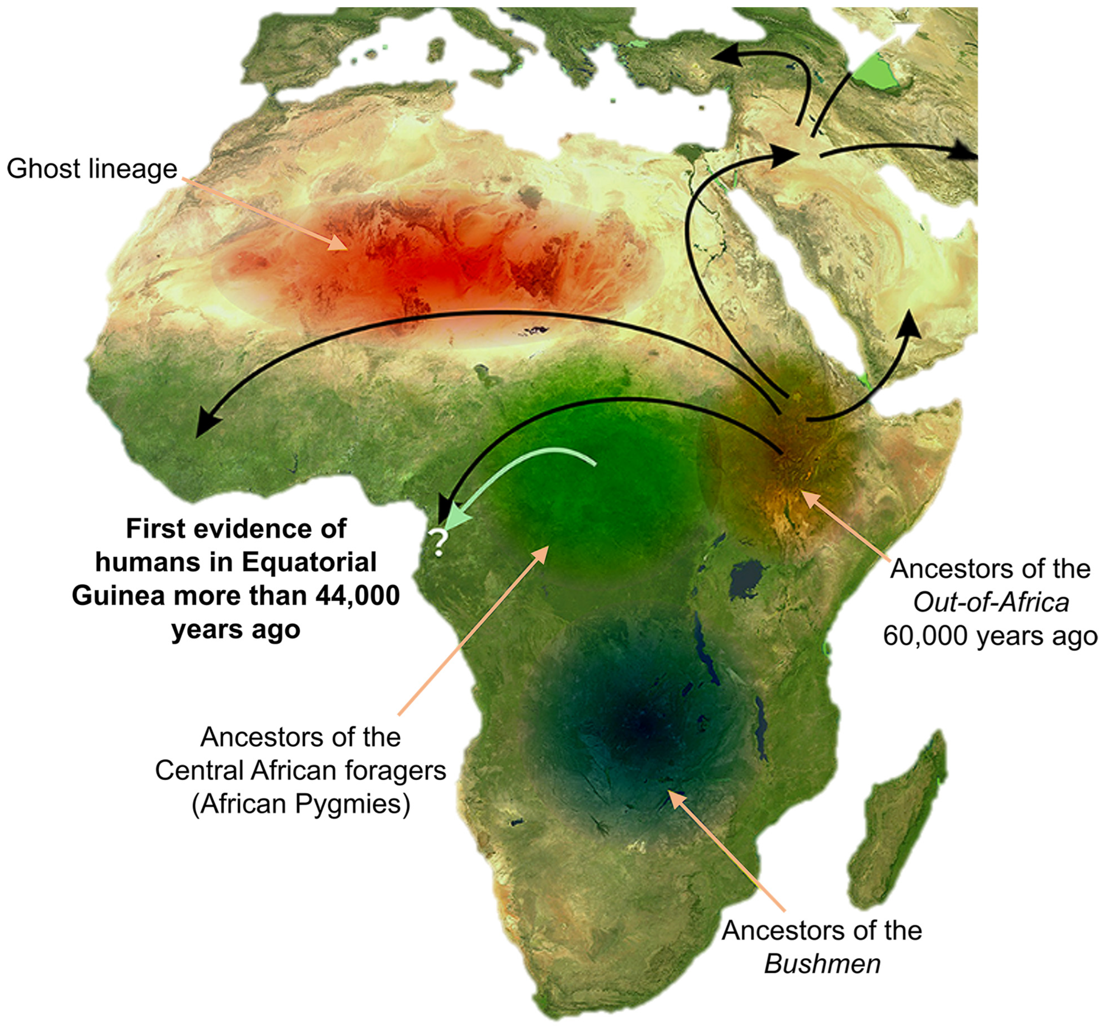
While the distribution of Lupemban technology across present-day rainforest environments is demonstrated by a range of evidence from West–Central Africa, the more structured archeological sequences that provide the best-defined chronological landmarks come from the eastern forest belt or beyond (Figure 5). However, recent analyses of the Beté site (Ivory Coast), whose archeological record comes from a clear rainforest context, are allowing researchers to begin delineating the archeological sequence of this ecosystem with greater precision [49].

4. Actualistic Approach

4.1. Review of the Environmental Characteristics of the Current Rainforest and Their Relationship with the Conservation of Archeo-Paleontological Materials

In order to document the taphonomic phenomenology of the preservation of skeletal remains in a rainforest environment, observational studies have been conducted within the Monte Alén National Park [51]. This protected area of extreme ecological value has remained highly conserved due to its difficult access, maintaining large tracts of primary rainforest [52]. Several areas of Monte Alén have been explored in different campaigns, covering a total of 206 km on foot, with 156 h of recording and documentation. In order to exhaustively cover as much ground as possible, a transect methodology was used, adapted where necessary to the characteristics of the environment (vegetation, watercourses, natural obstacles, etc.). At the same time, a wide network of information provided by the local population and forest guides complemented our direct observations.
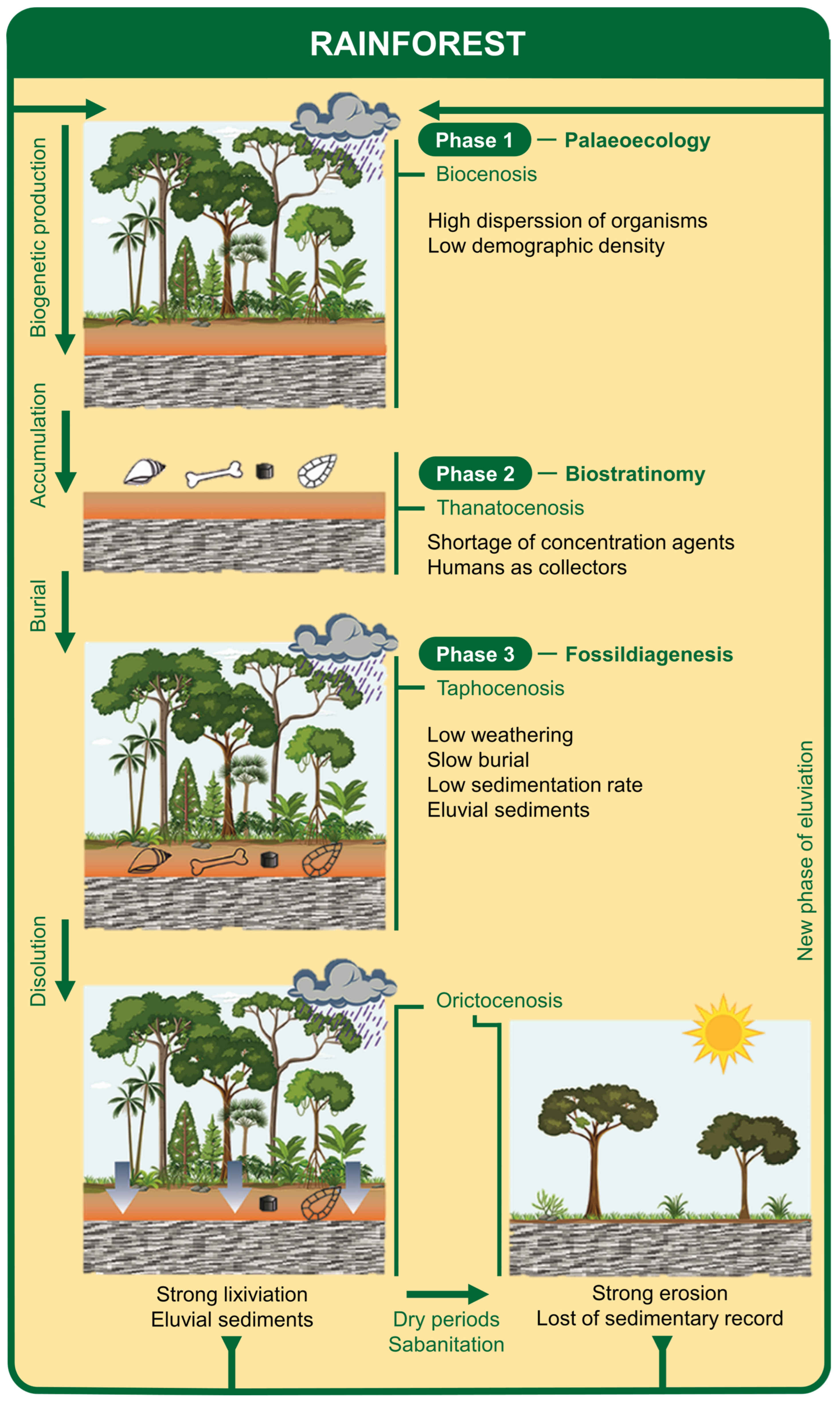
Thanks to a neotaphonomic approach, a number of specific factors have emerged that facilitate the explanation of the sparse fossil record in areas such as West Central Africa [19,51] (Figure 6): (a) ecological factors in the rainforest condition a high dispersion of organisms within the ecosystem, generating low population densities that avoid large accumulations of carcasses; (b) biostratinomic processes stand out for the absence of concentration agents of the dispersed remains generated, such as the lack of scavengers and sedimentary accumulation processes, although a cumulative effect by living human populations has been detected; (c) the fossildiagenetic processes act in two phases: first the burial of the generated entities is very slow due to the low sedimentation rates, so that, finally, the phases of high rainfall dissolve and leach the materials while the more arid phases of savanization lead to the almost total erosion of the sediments with the loss of most of the very limited record that could have been preserved.

4.2. Modeling of Anthropogenic Deposits in Potential Archeo-Paleontological Sites in Equatorial Guinea

The almost total absence of Quaternary paleontological sites in African rainforest areas greatly limits our knowledge of the recent evolution of these ecosystems [8]. Likewise, knowledge of the vertebrate communities of present-day rainforests in Central Africa is very limited due to the difficulties of their study [53]. In the campaigns carried out in Equatorial Guinea, approaches to these fields of study have been made from the analysis of accumulations of vertebrate skeletal elements sampled in five villages of the continental zone [54] (Figure 7). The analysis of this type of material is unusual in current zoological and ecological studies but has provided valuable data for the characterization of faunal communities in specific areas and chronologies that are directly extrapolated to the reconstruction of environmental contexts in archeo-paleontological sites. Specifically, the taxonomic associations found in areas such as Monte Alén faithfully represent the typical communities of tropical forests in Central Africa, especially when the components of these communities are characterized by their ecotypes [53] (Figure 7).
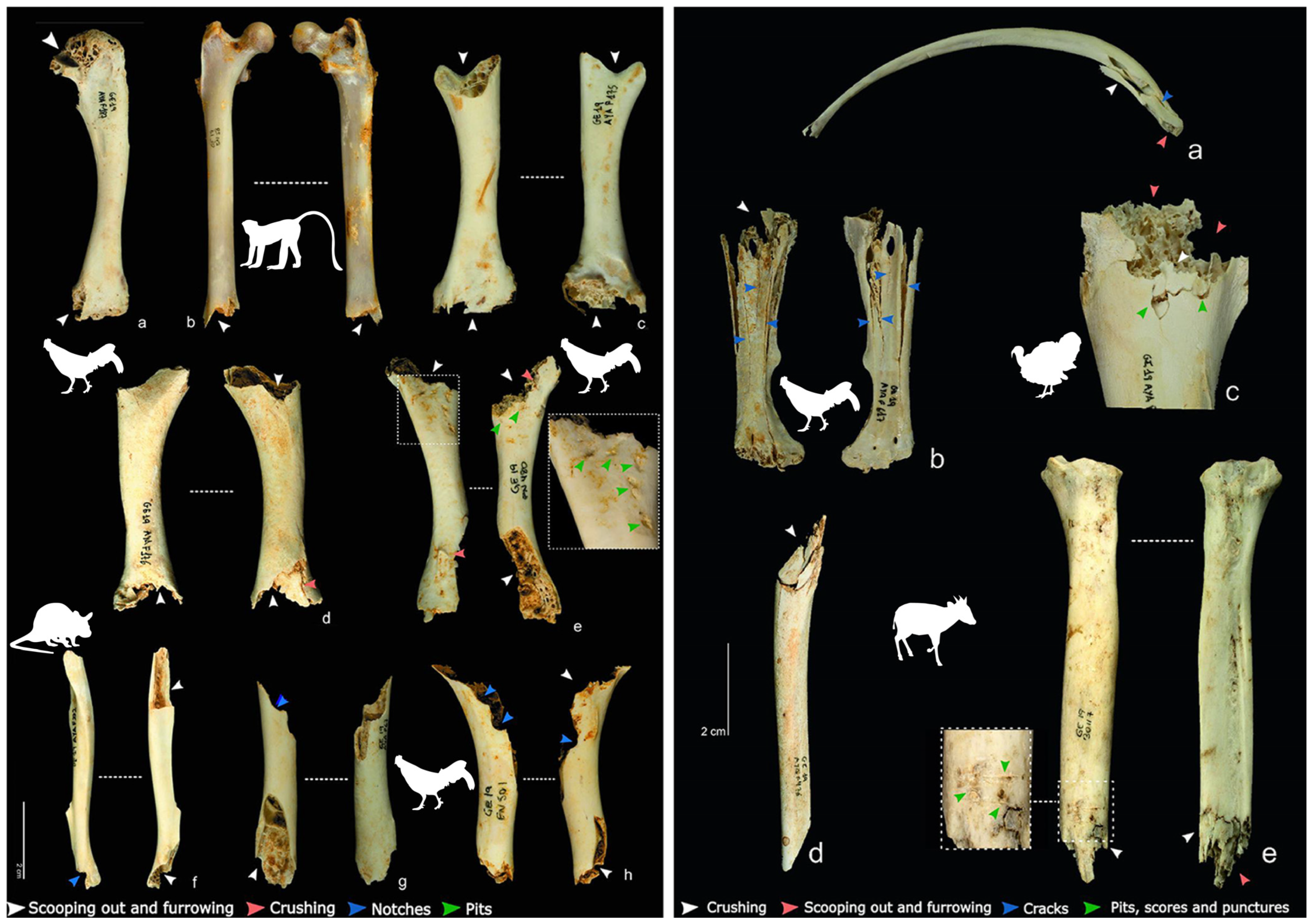
Another aspect on which there was limited previous information is the peculiarities of faunal accumulations made by human populations in contexts of high hunting pressure for subsistence purposes. In order to gain a better understanding of this type of proto-archeological contexts and their implications for the reconstruction of archeological sites, more exhaustive sampling of bone remains has been carried out in settlements on the mainland of Equatorial Guinea [55]. With the results obtained, it has been possible to characterize the peculiarities of human feeding marks on faunal bone elements, determining the presence of a high intensity of human bite marks on small animals and an almost indistinguishable mark on large animals (Figure 7). These same studies have highlighted some biases in the taxonomic composition of these accumulations derived from anthropogenic intervention, such as the absence of animals weighing less than 1 kg and the over-representation of species with individuals weighing between 1 and 10 kg.

4.3. Primate Monitoring. Identification of a Group of Chimpanzees (Pan Troglodytes Troglodytes)

In another line of research undertaken in Equatorial Guinea, we set out to study the origin of bipedal locomotion. As this is an essential human trait, establishing how it originated is paramount to understanding human evolution. Paleontological data indicate that bipedalism must have originated immediately after the divergence of the Homo and Pan (chimpanzee genus) lineages, between 6 and 7 Ma ago, from the last common ancestor (LCA) shared by both lineages [1]. However, the how, where, and why of this divergence are still uncertain, so we set out to characterize the ecological niche where bipedal locomotion emerged by reconstructing the locomotor repertoire and habitat use of the Homo-Pan LCA. For this purpose, we searched for paleobiological evidence in primary equatorial forest ecosystems, essentially similar to the one where bipedalism may have originated. In Equatorial Guinea, there are still some of these forests—nowadays Protected Areas—so we studied movement patterns in current primates in order to know, through phylogenetic inferences, the mode of locomotion of the LCA. The place chosen was the Monte Alén National Park, whose native forest has exceptional conditions: it is home to 16 species of primates [11], including the two living species phylogenetically closest to man, the chimpanzee and the lowland gorilla (Gorilla gorilla gorilla), in sympatry, i.e., sharing the same geographical space.
This objective would rest on two main pillars: on the one hand, locating hypothetical fossils that physically represent LCA Homo/Pan. Although such fossils have not yet been discovered in Central Africa, the discovery of any primate record in this rainforest context would represent a turning point in world paleoanthropology. Secondly, the analysis of the locomotor repertoire and habitats of the primates from Monte Alén: to this end, original field data were collected through direct observation and filming. Subsequently, locomotion modes were classified according to Hunt et al. [56] and quantified in order to translate locomotor data into phenotypic variables. In parallel, botanical characterization was pursued in the biotopes occupied by the primates. With these data, we seek to infer the ecological niche and a model of locomotion and habitat use for the Homo/Pan LCA and its contrast with those of ‘suspension under branches’ versus ‘multi-branched quadruped’.
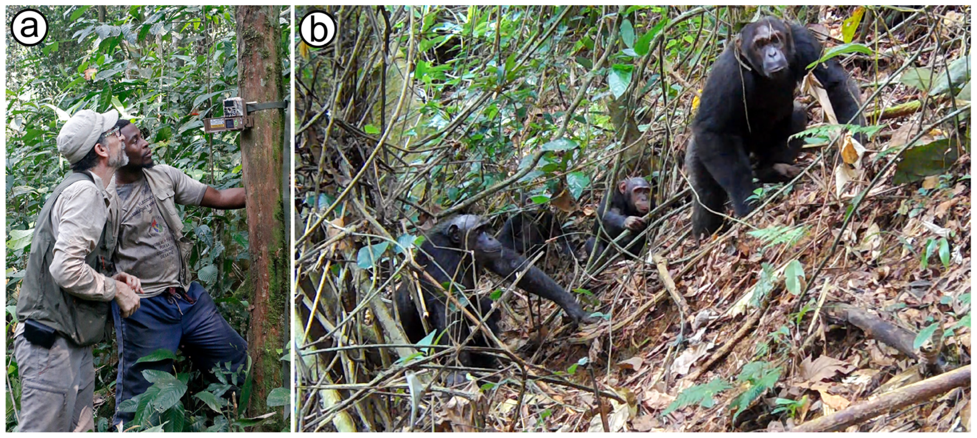
For the filming of primates in their natural state, photo-trapping (Figure 8a) proved to be very useful among the different techniques used (direct filming, drones, etc.). Thus, between the years of 2019 and 2023, a total of five camera traps were recording in different areas of Monte Alén. For all this study, we were advised by local guides to choose the most suitable places (passage areas, feeding areas, etc.). During these campaigns, a wide variety of mammal species was recorded, including several primates along with some birds and reptiles. However, the characterization of a well-identified chimpanzee breeding group [57] (Figure 8b) in the area around Engong stands out, both for the ecological and iconic value of this species, as well as for its relationship with our research. The results are complemented by a series of transects in which different signs of presence (nests, feeding remains, footprints, droppings, etc.) have been located. Likewise, other primate species have been filmed in the same territory: gorillas (Gorilla gorilla gorilla), mandrills (Mandrillus sphinx), bushbabys (Euoticus elegantulus and possibly Sciurocheirus gabonensis), and several cercopithecins (guenons) such as red-tailed monkey (Cercopithecus cephus).
The group of chimpanzees (Pan troglodytes ssp. troglodytes) is composed of eight individuals of which six are adults and two are immature (one juvenile and one infant). Of the adults, three are females and three are males; the juvenile appears to be male and the sex of the infant has not been determined. As in other chimpanzee communities, Engong is a group with family or kinship relationships, some very close, such as mother–child relationships (a female, a young daughter and a baby, where they share the upbringing), as well as others. For this period, no other external or roaming members or interactions with other chimpanzee groups have been observed [57,58].
As preliminary conclusions of this part of the study, we can advance that it is a family group, cohesive and stable, although of a small size for what chimpanzee communities usually are, in any case smaller than those published by previous studies in Equatorial Guinea [57,58,59,60,61,62]. There appears to be a low chimpanzee population density (also observed in the gorilla group), with small groups and little interaction with other groups/communities, perhaps due to geographic isolation or a low overall chimpanzee density in this National Park. Among the threats faced by this subspecies, classified as Endangered according to the IUCN Red List of Threatened Species, human pressure is possibly the most relevant factor, with poaching leading the way, for this low density observed in Monte Alén, as the size of the territory and the trophic resources available seem to be sufficient to accommodate larger communities [57,58].

5. Discussion and Conclusions

The orography, geology, and general environmental context of Equatorial Guinea predispose a very complex environment for archeo-paleontological finds [51]. Despite this situation, the Paleoanthropology Team of the National Museum of Natural Sciences (CSIC) has carried out 11 field campaigns in this area of West Africa, obtaining a large amount of archeological data that fill in large gaps in knowledge [11]. The discovery of archeological sites in the MSA, such as the Campo 11 site, the performance of absolute dating, and the discovery of numerous Paleolithic archeological remains scattered throughout the territory stand out [20].
In contrast to the archeological record, strictly paleontological findings have been negative, reinforcing the idea of the great difficulty in preserving the fossil record in rainforest areas [51]. Even so, efforts to study the present-day rainforest environment have shed light on how these ecosystems function. Neotaphonomic characterization has made it possible to propose a new general theoretical framework to explain the absence of a fossil record in Central Africa [51]. On the other hand, the exhaustive documentation of present-day anthropogenic accumulations in forest areas has provided data on the potential of studying this type of natural materials for the interpretation of the ecosystems in which they are integrated [54] and for obtaining cultural data on the populations that have generated them [55].
Finally, the detailed observation of some of the closest current representatives of our own species (chimpanzees and gorillas) contributes to the characterization of the diversity in their populations, largely following in the footsteps opened more than 50 years ago by the great primatologist J. Sabater Pi [63,64].

Author Contributions

Conceptualization, A.R.; methodology, A.R., A.G.-T., D.F., J.I.M., P.S., M.F.M. and C.E.E.; formal analysis, A.R., A.G.-T., D.F., J.I.M. and P.S.; investigation, A.R., A.G.-T., D.F., J.I.M., P.S., M.F.M. and C.E.E.; resources, A.R.; data curation, A.G.-T. and C.E.E.; writing—original draft preparation, A.R. and D.F.; writing—review and editing, A.R., D.F., A.G.-T. and J.I.M.; project administration, A.R. and A.G.-T.; funding acquisition, A.R. All authors have read and agreed to the published version of the manuscript.

Funding

Several institutions financially supported the project: Ministerio de Ciencia e Innovación (MICINN/FEDER; CGL2016-75109-P, PID2021-122356NB-I00 and CGL2017-90984-EXP), PIAR-CSIC (201938014, PIAR-2023-11), i-COOP (COOPB20518), and Fundación Palarq.

Data Availability Statement

All data associated with this work are available in association with the referenced publications.

Acknowledgments

We express our gratitude to Nadia Valentín, Director of the Centro Cultural de España in Bata, for her constant support and to all those who in one way or another have lent us a hand in the successive field campaigns. To José Martín Michá Obiang, INDEFOR’s magnificent driver.

Conflicts of Interest

The authors declare no conflicts of interest.

References

  1. Rosas, A. Los Fósiles de Nuestra Evolución; Ariel: Madid, Spain, 2019. [Google Scholar]
  2. Harvati, K.; Stringer, C.; Grün, R.; Aubert, M.; Allsworth-Jones, P.; Folorunso, C.A. The Later Stone Age Calvaria from Iwo Eleru, Nigeria: Morphology and Chronology. PLoS ONE 2011, 6, e24024. [Google Scholar] [CrossRef]
  3. Crevecoeur, I.; Brooks, A.; Ribot, I.; Cornelissen, E.; Semal, P. Late Stone Age human remains from Ishango (Democratic Republic of Congo): New insights on Late Pleistocene modern human diversity in Africa. J. Hum. Evol. 2016, 96, 35–57. [Google Scholar] [CrossRef]
  4. Almécija, S.; Hammond, A.S.; Thompson, N.E.; Pugh, K.D.; Moyà-Solà, S.; Alba, D.M. Fossil apes and human evolution. Science 2021, 372, eabb4363. [Google Scholar] [CrossRef]
  5. Lovejoy, C.O.; Suwa, G.; Simpson, S.W.; Matternes, J.H.; White, T.D. The Great Divides: Ardipithecus ramidus Reveals the Postcrania of Our Last Common Ancestors with African Apes. Science 2009, 326, 100–106. [Google Scholar] [CrossRef] [PubMed]
  6. White, T.D.; Suwa, G.; Asfaw, B. Australopithecus ramidus, a new species of early hominid from Aramis, Ethiopia. Nature 1994, 371, 306–312. [Google Scholar] [CrossRef] [PubMed]
  7. Simpson, G.G. Principles of Animal Taxonomy; Columbia University Press: New York, NY, USA, 1961. [Google Scholar]
  8. Roberts, P.; Petraglia, M. Pleistocene rainforests: Barriers or attractive environments for early human foragers? World Archaeol. 2015, 47, 718–739. [Google Scholar] [CrossRef]
  9. Rosas, A.; Fero Meñe, M.; García-Tabernero, A. Segunda expedición paleoantropológica a Guinea Ecuatorial. El estuario del Río Muni. Naturalmente 2019, 21, 26–32. [Google Scholar]
  10. Rosas, A.; García-Tabernero, A.; Fidalgo, D.; Meñe, M.F.; Rodríguez-Berriguete, A.; Ebana Ebana, C.; Ornia, M.; Fernández-Martínez, J.; Morales, J.I. Widespread evidence of Middle Stone Age (MSA) presence in Equatorial Guinea (West-Central Atlantic Africa). Quat. Int. 2025, 736, 109849. [Google Scholar] [CrossRef]
  11. Rosas, A. Tesoros Naturales de Guinea Ecuatorial; Catarata: Madrid, Spain, 2022. [Google Scholar]
  12. Rosas, A.; García-Tabernero, A.; Fidalgo, D.; Fero Meñe, M. Catálogo de la Exposición Historia Natural de Guinea Ecuatorial. Zenodo 2023, 1–11. [Google Scholar]
  13. Martínez-Torres, L.M.; Riaza, A. Explicación del Mapa Geológico de Guinea Ecuatorial Continental; Asociación Africanista Manuel Iradier: Bilbao, Spain, 1996. [Google Scholar]
  14. Lerebours-Pigeonnière, A.; Ovono, F.E. Atlas de Guinea Ecuatorial. Atlas de l’Afrique; Éditions J.A.: Paris, Farnce, 2001. [Google Scholar]
  15. Schlüter, T. Cameroon. Geological Atlas of Africa; Editorial Springer: Berlin/Heidelberg, German, 2006. [Google Scholar]
  16. Meyers, J.B.; Rosendahl, B.R.; Groschel-Becker, H.; Austin, J.A., Jr.; Rona, P.A. Deep penetrating MCS imaging of the rift-to-drift transition, offshore Douala and North Gabon basins, West Africa. Mar. Pet. Geol. 1996, 13, 791–835. [Google Scholar] [CrossRef]
  17. Ornia, M.; Rodríguez Berriguete, A. Geología histórica de Guinea Ecuatorial. In Tesoros Naturales de Guinea Ecuatorial; Rosas, A., Ed.; Catarata: Madrid, Spain, 2022; pp. 19–34. [Google Scholar]
  18. Rosas, A.; García-Tabernero, A.; Fero Meñe, M.; Ebana Ebana, C.; Feme Mba, F. Paleo-anthropological explorations in Equatorial Guinea (West Central Africa). The estuary of the Muni River. In 9th Annual Meeting of the ESHE; European Society for the Study of Human Evolution: Liège, Belgium, 2019. [Google Scholar]
  19. Rosas, A.; Ornia, M.; García-Tabernero, A.; Sánchez Moral, S. El Cuaternario de Guinea Ecuatorial. In Tesoros Naturales de Guinea Ecuatorial; Rosas, A., Ed.; Catarata: Madrid, Spain, 2022; pp. 47–66. [Google Scholar]
  20. Rosas, A.; García-Tabernero, A.; Fidalgo, D.; Fero Meñe, M.; Ebana Ebana, C.; Ornia, M.; Sánchez del Moral, S.; Morales, J.I. Middle Stone Age (MSA) in the Atlantic rainforests of Central Africa. The case of Río Campo region in Equatorial Guinea. Quat. Sci. Rev. 2025, 349, 109132. [Google Scholar] [CrossRef]
  21. Rosas, A.; García-Tabernero, A.; Morales, J.I.; Rodríguez Berriguete, A.; Fero Meñe, M.; Esono Mba, F.; Sánchez del Moral, S. Inicio del poblamiento prehistórico en la isla de Bioko (Guinea Ecuatorial). Cuaternario Y Geomorfol. 2021, 35, 129–145. [Google Scholar] [CrossRef]
  22. Sánchez Moral, S.; Rodríguez Berriguete, A. Formación de las islas volcánicas de Bioko y Annobón. In Tesoros Naturales de Guinea Ecuatorial; Rosas, A., Ed.; Catarata: Madrid, Spain, 2022; pp. 35–46. [Google Scholar]
  23. Rosas, A. Primera expedición paleoantropológica a Guinea Ecuatorial. Naturalmente 2015, 3, 30–36. [Google Scholar]
  24. Terrazas, A.; Rosas, A. A New Approach to the Middle Stone Age from Continental Equatorial Guinea: A Preliminary Fielwork Report. Nyame Akuma 2016, 85, 129–139. [Google Scholar]
  25. Mercader, J. Forest people: The role of African rainforests in human evolution and dispersal. Evol. Anthropol. Issues News Rev. 2002, 11, 117–124. [Google Scholar] [CrossRef]
  26. Ruhe, R.V. Stone lines in soils. Soil Sci. 1959, 87, 223–231. [Google Scholar] [CrossRef]
  27. Mercader, J.; Martí, R.; Martínez, J.L.; Brooks, A. The nature of ‘stone-lines’ in the African quaternary record: Archaeological resolution at the rainforest site of Mosumu, Equatorial Guinea. Quat. Int. 2002, 89, 71–96. [Google Scholar] [CrossRef]
  28. Rosas, A.; Morales, J.I.; García-Tabernero, A. Primeras ocupaciones prehistóricas en Guinea Ecuatorial. In Tesoros Naturales de Guinea Ecuatorial; Rosas, A., Ed.; Catarata: Madrid, Spain, 2022; pp. 247–260. [Google Scholar]
  29. Martin del Molino, A. Prehistoria de Guinea Ecuatorial. Africa 2000 1989, 4–21. [Google Scholar]
  30. Perramon, R. Contribución a la Prehistoria y Protohistoria de Rio Muni; Instituto Claretiano de Africanistas: Santa Isabel de Fernando Poo, Equatorial Guinea, 1968. [Google Scholar]
  31. Martí, R.; Mercader, J.; Fernández, N. El origen de la ocupación humana en la Isla de Bioko. Arqueología, Historia y Etnografía. Rev. Arqueol. 2000, 232, 14–23. [Google Scholar]
  32. Mercader, J.; Martí, R. Middle Stone Age sites in the tropical forests of Equatorial Guinea. Nyame Akuma 1999, 51, 14–24. [Google Scholar]
  33. Taylor, N. The origins of hunting & gathering in the Congo basin: A perspective on the Middle Stone Age Lupemban industry. Before Farming 2011, 1–20. [Google Scholar]
  34. Taylor, N. Central and West African Middle Stone Age: Geography and Culture. In Encyclopedia of Global Archaeology; Smith, C., Ed.; Springer: New York, NY, USA, 2014; pp. 1208–1227. [Google Scholar]
  35. Taylor, N. Across Rainforests and Woodlands: A Systematic Reappraisal of the Lupemban Middle Stone Age in Central Africa. In Africa from MIS 6-2: Population Dynamics and Paleoenvironments; Jones, S.C., Stewart, B.A., Eds.; Springer: Dordrecht, The Netherlands, 2016; pp. 273–299. [Google Scholar]
  36. Clark, J.D. The Later Pleistocene Cultures of Africa. Science 1965, 150, 833–847. [Google Scholar] [CrossRef] [PubMed]
  37. Clark, J.D. Kalambo Falls Prehistoric Site: The Geology, Palaeoecology and Detailed Stratigraphy of the Excavations; Cambridge University Press: Cambridge, UK, 1969; Volume 1. [Google Scholar]
  38. Clark, J.D. Kalambo Falls Prehistoric Site: The Earlier Cultures: Middle and Earlier Stone Age; Cambridge University Press: Cambridge, UK, 2001; Volume 3. [Google Scholar]
  39. Barham, L.S.; Smart, P.L. An early date for the Middle Stone Age of central Zambia. J. Hum. Evol. 1996, 30, 287–290. [Google Scholar] [CrossRef]
  40. Duller, G.A.; Tooth, S.; Barham, L.; Tsukamoto, S. New investigations at Kalambo Falls, Zambia: Luminescence chronology, site formation, and archaeological significance. J. Hum. Evol. 2015, 85, 111–125. [Google Scholar] [CrossRef]
  41. van Peer, P.; Fullagar, R.; Stokes, R.; Bailey, R.; Moeyersons, J.; Steenhoudt, R.; Geerts, A.; Vanderbeken, T.; Dapper, M.; Geus, F. The Early to Middle Stone Age Transition and the Emergence of Modern Human Behaviour at site 8-B-11, Sai Island, Sudan. J. Hum. Evol. 2003, 45, 187–193. [Google Scholar] [CrossRef]
  42. van Peer, P.; Rots, V.; Vroomans, J.-M. A Story of Colourful Diggers and Grinders: The Sangoan and Lupemban at site 8-B-11, Sai Island, Northern Sudan. Before Farming 2004, 1–28. [Google Scholar] [CrossRef]
  43. Rots, V.; Van Peer, P. Early evidence of complexity in lithic economy: Core-axe production, hafting and use at Late Middle Pleistocene site 8-B-11, Sai Island (Sudan). J. Archaeol. Sci. 2006, 33, 360–371. [Google Scholar] [CrossRef]
  44. Mercader, J.; Martí, R.; González, I.J.; Sánchez, A.; García, P. Archaeological Site Formation in Rain Forests: Insights From the Ituri Rock Shelters, Congo. J. Archaeol. Sci. 2003, 30, 45–65. [Google Scholar] [CrossRef]
  45. Martí, R. La secuencia arqueológica en el cinturón forestal centroafricano. Espac. Tiempo Y Forma Ser. I Prehist. Y Arqueol. 1999, 12, 41–66. [Google Scholar] [CrossRef]
  46. McBrearty, S. The Sangoan-Lupemban and middle stone age sequence at the Muguruk site, western Kenya. World Archaeol. 1988, 19, 388–420. [Google Scholar] [CrossRef]
  47. Barham, L.S. Central Africa and the emergence of regional identity in the Middle Pleistocene. In Human Roots: Africa and Asia in the Middle Pleistocene; Barham, L.S., Robson Brown, K., Eds.; Western Academic and Specialist Press: Bristol, UK, 2001; pp. 65–80. [Google Scholar]
  48. Banks, W.E.; d’Errico, F.; Dibble, H.L.; Krishtalka, L.; West, D.; Olszewski, D.I.; Peterson, A.T.; Anderson, D.G.; Gilliam, J.C.; Montet-White, A. Eco-Cultural Niche Modeling: New Tools for Reconstructing the Geography and Ecology of Past Human Populations. Paleoanthropology 2006, 2006, 68–83. [Google Scholar]
  49. Ben Arous, E.; Blinkhorn, J.A.; Elliott, S.; Kiahtipes, C.A.; N’zi, C.D.; Bateman, M.D.; Duval, M.; Roberts, P.; Patalano, R.; Blackwood, A.F. Humans in Africa’s wet tropical forests 150 thousand years ago. Nature 2025, 640, 402–407. [Google Scholar] [CrossRef] [PubMed]
  50. Lipson, M.; Ribot, I.; Mallick, S.; Rohland, N.; Olalde, I.; Adamski, N.; Broomandkhoshbacht, N.; Lawson, A.M.; Lopez, S.; Oppenheimer, J. Ancient West African foragers in the context of African population history. Nature 2020, 577, 665–670. [Google Scholar] [CrossRef] [PubMed]
  51. Rosas, A.; García-Tabernero, A.; Fidalgo, D.; Fero Meñe, M.; Ebana Ebana, C.; Esono Mba, F.; Morales, J.I.; Saladié, P. The scarcity of fossils in the African rainforest. Archaeo-paleontological surveys and actualistic taphonomy in Equatorial Guinea. Hist. Biol. 2022, 34, 1582–1590. [Google Scholar]
  52. Velayos, G.; Barberá, P.; Cabezas, F.J.; Fero, M.; Velayos, M. Checklist of the vascular plants of Río Muni (Equatorial Guinea): Floristic analysis, diversity, endemicity, and threatened status. An. Del Jardín Botánico De Madr. 2023, 80, 211–1322. [Google Scholar]
  53. Fidalgo, D.; Rosas, A. Estructura de las comunidades faunísticas en Guinea Ecuatorial. In Tesoros Naturales de Guinea Ecuatorial; Rosas, A., Ed.; Catarata: Madrid, Spain, 2022; pp. 129–146. [Google Scholar]
  54. Rosas, A.; Aguado, L.; García-Tabernero, A.; Saladié, P.; Fero Meñe, M.; Ebana, C.; Esono Mba, F.; Morales, J.I.; Andrews, P. Bushmeat skeletal waste from an Atlantic African rainforest (Equatorial Guinea) as a test for the Mammal Community Structure Analysis in paleoecology. Int. J. Osteoarchaeol. 2021, 31, 440–455. [Google Scholar] [CrossRef]
  55. Saladié, P.; Rosas, A.; García-Tabernero, A.; Fidalgo, D.; Fero Meñe, M.; Ebana Ebana, C. An actualistic taphonomic model of human tooth marks on bone remains: A sample recovered in villages of continental Equatorial Guinea. J. Archaeol. Sci. Rep. 2024, 55, 104514. [Google Scholar] [CrossRef]
  56. Hunt, K.D.; Cant, J.G.H.; Gebo, D.L.; Rose, M.D.; Walker, S.E.; Youlatos, D. Standardized descriptions of primate locomotor and postural modes. Primates 1996, 37, 363–387. [Google Scholar] [CrossRef]
  57. Demetrio, E. Caracterización de un Grupo Reproductivo de Chimpancés en el Parque Nacional Monte Alén, Guinea Ecuatorial. Degree Thesis, Universidad Autónoma de Madrid, Madrid, Spain, 2023. [Google Scholar]
  58. Rosas, A.; García-Tabernero, A.; Mba, J. Los primates y las raíces evolutivas de los seres humanos. In Tesoros Naturales de Guinea Ecuatorial; Rosas, A., Ed.; Catarata: Madrid, Spain, 2022; pp. 227–246. [Google Scholar]
  59. Goodall, J. The chimpanzees of Gombe: Patterns of Behavior; Harvard University Press: Cambridge, UK, 1986. [Google Scholar]
  60. Lehmann, J.; Boesch, C. To fission or to fusion: Effects of community size on wild chimpanzee (Pan troglodytes verus) social organization. Behav. Ecol. Sociobiol. 2004, 56, 207–216. [Google Scholar] [CrossRef]
  61. Mitani, J.C.; Watts, D.P. Correlates of territorial boundary patrol behaviour in wild chimpanzees. Anim. Behav. 2005, 70, 1079–1086. [Google Scholar] [CrossRef]
  62. Nakamura, M.; Hosaka, K.; Itoh, N.; Zamma, K. Mahale Chimpanzees: 50 Years of Research; Cambridge University Press: Cambridge, UK, 2015. [Google Scholar]
  63. Jones, C.; Sabater Pi, J. Sticks used by chimpanzees in Rio Muni, West Africa. Nature 1969, 223, 100–101. [Google Scholar] [CrossRef] [PubMed]
  64. Sabater Pi, J. Etología de la Vivienda Humana: De Los Nidos de Gorilas y Chimpancés a la Vivienda Humana; FisicalBook: Barcelona, Spain, 1985. [Google Scholar]
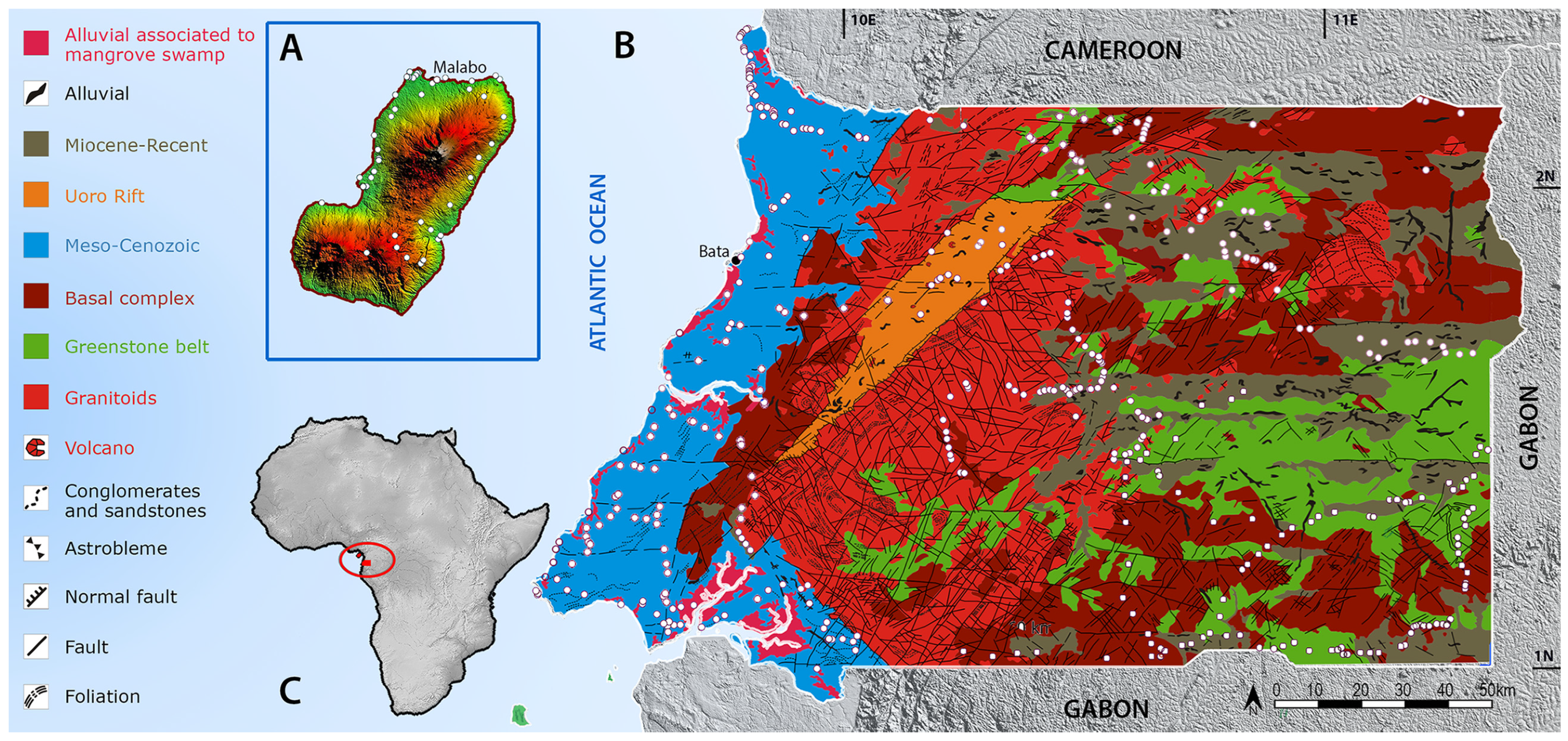
Figure 1. Geological map of Equatorial Guinea. On the left is the island of Bioko and on the right the continental part of the country. According to Rosas et al. [10] (modified from Martínez-Torres y Riaza [13]). In the image above is the location of the points prospected until the 2023 campaign. (A) Bioko Island. (B) Continental region (Muni River). (C) Location of Equatorial Guinea in Africa.
Quaternary 08 00045 g001
Figure 2. Archeo-paleontological surveys in Equatorial Guinea. The Spanish–Equatoguinean team prospecting in the 2021 fieldwork season at Río Campo.
Quaternary 08 00045 g002
Figure 3. Excavation at the site of the Campo 11 locality (paleo-basin of the Ntem River) during the 2021 campaign.
Quaternary 08 00045 g003
Figure 4. Representation of the lithic industry recovered in Equatorial Guinea. (a) Flint flake in situ at Campo 31. (b,c) Views of another flint flake also in situ at Campo 11. Axe-core (d), bifacial point (e), levallois flake (f), levallois cores (g,h), chipped tools-bipolar cores (i). Modified from Rosas et al. [28].
Quaternary 08 00045 g004
Figure 5. Map of Africa some 60,000 years ago showing the location of the four basal trunks of H. sapiens (according to Lipson et al. [50]) and the dispersal of the East African group. Based on our findings, the earliest human evidence in Equatorial Guinea dates to between 44 and 24 Ka ago.
Quaternary 08 00045 g005
Figure 6. Synthetic diagram of the main taphonomic processes acting in present-day African Atlantic rainforests affecting the preservation of organic remains (fossils). Modified from Rosas et al. [51].
Quaternary 08 00045 g006
Figure 7. Different types of human exploitation marks (bites) on bones of animals hunted in the rainforest (forest meat) usually consumed in the villages. Modified from Saladié et al. [55].
Quaternary 08 00045 g007
Figure 8. Study of current primate communities. (a) Placement of photo-trapping cameras in the Monte Alen National Park. (b) Image of a group of chimpanzees.
Quaternary 08 00045 g008
Disclaimer/Publisher’s Note: The statements, opinions and data contained in all publications are solely those of the individual author(s) and contributor(s) and not of MDPI and/or the editor(s). MDPI and/or the editor(s) disclaim responsibility for any injury to people or property resulting from any ideas, methods, instructions or products referred to in the content.