Abstract
In the northern part of the Niğde (Central Anatolian) Quaternary Bor Basin, stratigraphic sections P1 and P2 were sampled, reaching depths of 11 m and 25 m. The samples were analyzed with thin-section, XRD, and chemical analyses (ICP-MS) to determine their chemical and mineralogical properties. In the study area, partially lithified volcano-sedimentary rocks comprised paleosol, calcrete, gravel, sand, silt, mud, clay, and volcanoclastics such as pumice fall-out. Grain size analyses from the Zengen (P1) and Altunhisar (P2) regions showed very poor sorting and strong positive skewness. The Zengen-area (P1) samples contained rock fragments, calcite, quartz, opal-CT, feldspar, amphibole, pyroxene, biotite, and clay minerals such as smectite, chlorite, illite, palygorskite, and sepiolite. In calcrete zones, however, the amounts of CaO increased, whereas significant decreases in the amounts of SiO2 were observed. Therefore, a negative correlation between SiO2 and CaO was observed. The vertical distributions and behaviors of trace elements in the Zengen-area profile showed variation with the different levels of the P1 section. It is thought that in the Bor Plain, after 17,000 years ago, no lacustrine phase reached a level above the periglacial lake level in the region, reaching this level with the melting of the ice sheets in the area. During the late glacial period, shallow freshwater lacustrine phases and paleosols were identified from 12,500 to 11,000 yr BP in the basin.
1. Introduction
During the Pleistocene–Holocene period, also known as the Ice Age, paleosol, calcrete, lacustrine, volcanoclastic, and fluvial sediments formed in the Central Anatolian region of the Bor Basin captured indications of the climatic changes that occurred. These features manifest as thickness, color, and material variations among different sedimentary levels in the region.
The study area is bordered by the Taurus and Ulukışla Mountains to the south, the Niğde metamorphics to the east, the Melendiz volcanics to the north, and the Konya–Ereğli Plain to the west. The region is characterized by shallow marshes, red beds, and expansive steppe grasslands, most of which are saline. Over the last century, this plain has predominantly dried up.
The Quaternary history of lake basins in Central Anatolia has been the focus of numerous authors, addressing topics such as volcanism, geological mapping, sedimentology, stratigraphy, tectonics, paleosols, limnology, mineralogy, geochemistry, and palynostratigraphy. This basin in this study is fed by unconsolidated detritus from the Paleozoic–Mesozoic-aged Niğde metamorphics [1,2,3], the Paleocene–Quaternary-aged Ulukışla volcano-sedimentary rocks [4,5,6,7], and the Miocene–Quaternary-aged volcanic and volcano-sedimentary rocks of the Cappadocia Volcanic Province [8,9,10,11,12,13].
In the region concerning Quaternary fills, ref. [14] studied the diatom assemblage and paleoenvironmental characteristics of diatomites in the Çiftlik Basin (Niğde). Ref. [15] investigated the diatom assemblage and lithofacial properties of Ihlara–Selime diatomites. As part of a hydrogeological survey study of the Ereğli Bor Plain, ref. [16] conducted groundwater research in the region and prepared a 1/100,000-scale hydrogeological map of the area. Ref. [17] conducted studies on the physicochemical formation, carbonate diagenesis, and mineralogical content of paleosols and other sedimentary deposits in the lake environment of the Konya Plain. Ref. [18] determined the chronological age using the radiocarbon method in the Konya–Ereğli Plain and established its stratigraphic profile. Ref. [19] identified that the Konya Basin is situated 100 km away from Tuz Lake and highlighted its development between alluvial fan and lake shoreline regimes.
Additionally, researchers have established the lithostratigraphic sequence of the sediments. Researchers have carried out dating using the 14C method. Ref. [20] employed physicochemical, mineralogical, and geochemical data in the Konya Basin of Turkey to identify climatic changes during the Quaternary period. Ref. [21] researched the hydrogeochemistry of hot and mineral-rich waters with different circulation systems, mainly focusing on the Dertalan, Kemerhisar, and Çiftehan (Niğde) sources. Ref. [22] revealed that the Quaternary fills, termed Bor–Ereğli (Central Anatolia) Quaternary deposits, consist of units such as conglomerate, sandstone, mudstone, limestone, and paleosol–calcrete. They compared the findings of this study with previous dating and sedimentological findings made in the Konya Basin.
The study area, with its extensive surface area, is the subject of a unique study in this article. For the first time, we will be examining the geological, mineralogical, and geochemical content of the sedimentary fills in the northern part of this basin. This novel approach aims to determine the mineralogical and chemical properties of the weathered rocks, paleosols, calcretes, and lacustrine sediment layers in the Bor region, located on the edge of the Konya–Ereğli basin in Central Anatolia. The potential impact of this study on our understanding of paleoclimatic records is significant, making it a valuable addition to the field of science.
Study Area and Geological Setting
According to [1,23,24,25,26], the oldest units in the Bor Basin are rocks belonging to the Paleozoic–Mesozoic-aged Niğde metamorphics. These Niğde metamorphics include gneiss, mica schist, quartzite, marble, and metagabbro. Upper Cretaceous-aged volcanic and ophiolitic rocks overlie the metamorphic units and have taken on dome-like structures due to granodiorite intrusion. According to [4], the second-basement rocks of the Bor Basin belong to the Sansartepe Formation of the Ulukışla group and start with Tertiary-aged trachy-andesitic pillow lavas and other rocks such as monzonite–syenite.
The Sereyenkaya Formation, a unique geological formation, is composed of gravels derived from the Sansartepe Formation and intercalations of pillow lavas. Above this formation lies Başmakçı limestone, another distinctive feature. Cehritepe syenite, an Upper Paleocene-aged syenitic intrusion, stands out with its pinkish-white coloration due to its feldspars and also consists of biotite and dark-colored mafic minerals. The Köyderesi trachyte, located to the north of Ulukışla within the Serenkaya Formation, is a trachyte with unique, pink-colored feldspar microlites seen in a matrix, with observed phenocrysts of alkali feldspar and biotite (believed to be of Upper Paleocene age).
In the same basin, the Lower Lutetian-aged Karatepe limestone, which was deposited for the second time, is white and measured to be 50 m thick at the type section located south of Hasangazi Village. The Güney Formation starts with a gray mudstone–calcite turbidite sequence at its base, as measured at the type section in the Çalılı stream east of Güney Village, and transitions to normal turbidite sandstones towards the top. The Tayhacı andesite is an Upper Eocene-aged magmatic unit found around Tayhacıtepe, above the Güney Formation, consisting of white plagioclase, pyroxene, and biotite phenocrysts in a light gray–pinkish gray aphanitic matrix. It appears as stocks, sills, and dikes. The Upper Eocene-aged Dikmendedetepe trachyte surrounding the Dikmendede hill is a pink trachyte rich in large orthoclase crystals.
The Aktoprak Basin unconformably overlies the Ulukışla Basin and includes volcano-sedimentary rocks. It represents a continental basin, beginning with the Oligocene-aged Zeyvegediği Anhydrites (comprising gypsum and anhydrites, locally overlaid by greenish marls and whitish clayey limestones). The Kurtulmuştepe Formation consists of cream-white colored limestone, mudstone, and marl sequences. Following the Lower Miocene-Aquitanian, the Kızılöz Formation, which consists of red- and green-colored cross-bedded, coarse-grained sandstone and conglomerate, was deposited. The Middle Miocene-aged Kızıltepe Travertine represents unconformity in the region. Regarding the Kızılbayır Formation, observed both in the south and north of the basin, this unit generally consists of red-green colored, coarse-grained, large-scale cross-bedded sandstones. The Young Miocene-aged Katrandedetepe Formation consists of greenish-yellowish marl and white-colored limestones. The Pliocene-aged Beştepeler Formation is the youngest unit observed in the north of this basin, comprising loosely cemented, red-green colored sandstone and conglomerate with thin marl layers [1,23,24].
In the study area, in addition to the basement rocks mentioned above, rocks belonging to the Cappadocia Volcanic Province volcano-sedimentary rocks are also present (Figure 1). According to [27], these, named Balcı volcanites or Melendizdağ tuffs [8,28], are described as yellow-brown-purple-green-colored, limonitized and altered lavas, tuff, and various pyroclastics. They are distributed to the south of Melendizdağ, in the northern parts of Altunhisar town. Based on age determination using the K/Ar method, an age of 7.2 ± 0.9 My has been established [10]. The Late Pliocene–Early Quaternary-aged Yuvaköy volcanics consist of andesitic lava, tuff, agglomerate, and lahars. Within them, ignimbrites have been identified in places. The lavas have a hyalopilitic–porphyritic texture and consist of volcanic glass, plagioclase microlites, and granular pyroxene and amphibole within a matrix containing plagioclase, augite, biotite, and opacified amphibole crystals. The Melendizdağ volcanites consist of grey-black-colored andesitic lava and pyroclastics.
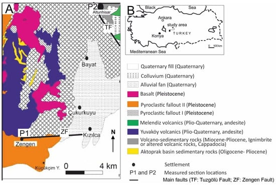
Figure 1.
(A) Simplified geological map of the study area (modified after [22]) and (B) study area.
2. Materials and Methods
In the study area, two representative stratigraphic sections have been measured: one within Quaternary-aged lake and fluvial sediments (Figure 2, P1) with a thickness of 11 m, and the other within Quaternary-aged lakeshore and slope debris sediments (Figure 3, P2) with a thickness of 10 m. The auxiliary sections are not presented in this article. The facies characteristics of paleosol (Ps), calcrete (Ca), gravel (Gm), sand (Sa), silt (Sl), mud (Md), and clay (Cl) levels have been identified (see profile descriptions), as well as volcanoclastics such as pumice fall-out (Pfo).
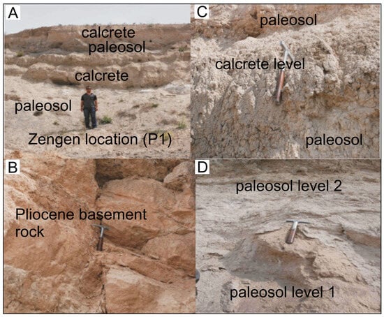
Figure 2.
General view of the Zengen area location P1: (A) general images of the location P1, (B) basement rock level (Pliocene), (C) calcrete level, and (D) paleosol levels.
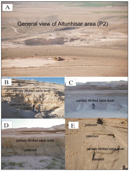
Figure 3.
Images of the Altunhisar location (P2): (A) general view; (B) pumice fall-out deposit, partially lithified sand level, and paleosol; (C) partially lithified sand level; (D,E) partially lithified sand level and paleosols.
Along both profiles, 19 partially lithified or semi-lithified samples of paleosol, calcrete, clay, mud, silt, sand, pumice clasts, and gravel have been taken, and field photographs of the stratigraphic sections have been captured (Figure 2 and Figure 3).
Grain Size Analysis: Granulometric analyses were performed using Walker’s method in ref. [29] to investigate the grain size variation in partially lithified or semi-lithified sedimentary samples.
Thin sections were prepared at the General Directorate of Mineral Research and Exploration (MTA, Ankara, Turkey) section lab to study the properties of partially lithified or semi-lithified sedimentary samples from the study area. The analyses were completed using a polarizing microscope (Nikon Poll 400, Niğde, Turkey) at Ömer Halisdemir University.
Within the scope of this study, samples particularly rich in clay grain size were selected in the field. ZT1–ZT5 samples are represented by basement rock samples of the area. Z1–Z13 samples are from the P1 section. The samples collected from the field were analyzed using a Bruker D8 Advanced XRD device with a Cu X-ray tube at the General Directorate of Mineral Research and Exploration (MTA) to identify their mineralogical properties. Mineral phases were initially identified from the XRD patterns, and the percentage quantities of the same minerals were determined using the SIROQUANT 3.0 software program.
The chemical analysis of 19 partially lithified or semi-lithified samples of paleosol, calcrete, clay, mud, sand, pumice, and gravel was performed at Acme Analytical Laboratories Ltd. (Vancouver, BC, Canada) using ICP-AES for major and trace elements and ICP-MS for rare earth elements (REEs). The detection limits for the analyses were 0.01 and 0.1 wt% for the major elements, 0.1 and 5 ppm for the trace elements, and 0.01 to 0.5 ppm for the REEs. ZT1–ZT5 samples are represented by basement rock samples of the area. Z1–Z13 samples are from the P1 section.
3. Results
3.1. Profile Descriptions and Facies Characteristics
As seen in Figure 4, a lithostratigraphic vertical section has been drawn for the Ereğli–Zengen area, labelled as the P1 section. This region’s most essential and representative lithostratigraphic vertical section is found near the Zengen sand quarry and its immediate vicinity (Zengen, 37°48′44″ N; 34°13′45″ E; profile start at 1100 m; in ref. [30]). The levels consist primarily of red-colored, carbonate-rich sequences of mudstone-intercalated paleosol and calcrete as basement rocks in the area of the Pliocene (Figure 4, ZT1–ZT5). The profile starts with approximately 1 m thickness of brown mature paleosol (Z1). A 1 m thick massive calcrete containing brown plant roots (Z2) is overlying this level. This is covered by 1 m thick brown paleosol and contains plant roots and pumice gravels (Z3). Above this paleosol layer is approximately a 1 m thick light brown massive calcrete containing plant roots (Z4). Grey-to-black-colored partially lithified or semi-lithified sand and gravel levels extend horizontally (Z5). Above the sand–gravel levels is a 1 m thick grey calcrete containing plant roots (Z6). This calcrete level is overlaid by a brown mature paleosol level (Z7), followed by a thin brown sandy level (Z8). A dark brown to black mature paleosol level (Z9) is above the thin sandy level. A massive calcrete level containing plant roots is dark brown and occurs as a thinner level in the P1 profile (Z10). Above this level, a massive brown calcrete-containing plant roots exists (Z11). On top of the massive calcrete level (Z11), there is a grey gravel level (Z12). At the top of all this material is a brown massive calcrete level (Z13). Multiple hiatuses occur among units Z1 and Z13 (diastem and unit gap), and the latter unit is covered by modern soil. The grain size of the modern soil is predominantly mud and occasionally contains gravel fragments (basalt and andesite). Other grain-size components include fine sand, rich in humus and mainly containing grass and other plant roots.
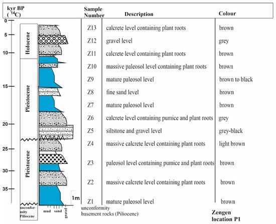
Figure 4.
A lithostratigraphic vertical section drawn for the Ereğli–Zengen region (P1); 14C ages modified from [22,31].
As depicted in Figure 5, a P2 lithostratigraphic vertical section has been meticulously described for the Niğde–Altunhisar area. The most essential and representative lithostratigraphic section for this region was identified near the Altunhisar sand quarry and its vicinity (Niğde–Altunhisar, 38°00′29″ N 34°21′20″ E; profile start at 1200 m). The base of the section consists of a 2 m thick layer of grey, partially lithified or semi-lithified gravel and sand interbedding (AD1). Above this, there is a 1 m thick layer of grey to white pumice fall-out (AD2). This is overlain by a 3.5–4 m thick layer of light grey sand (AD3). Above the sand, there is a 4 m thick brown paleosol layer (AD4). This is followed by a 1.5 m thick layer of white paleosol and sand (AD5), which is succeeded by a 1 m thick light brown paleosol and sand layer (AD6). These units are capped by modern soil, which is predominantly mud with occasional gravel pieces. The modern soil also contains fine sand, rich in humus, and mainly comprises grass and other plant roots.
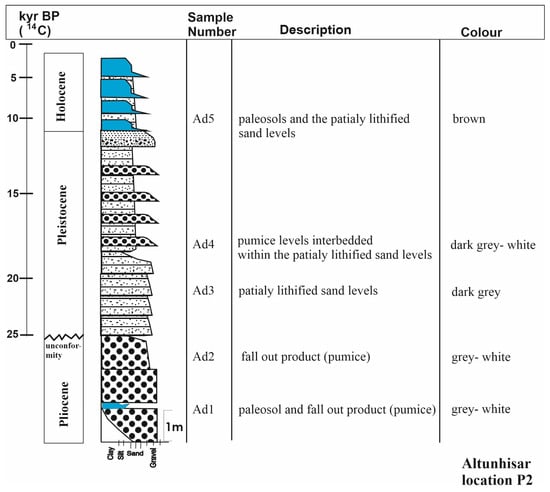
Figure 5.
Lithostratigraphic section of the paleosols and terrestrial sediments of the Altunhisar region (P2); 14C ages modified from [22,31].
3.2. Grain Size Analyses
It has been determined that the partially lithified sediments, paleosols, calcrete, and fall-out pumice representing certain levels are poorly sorted (Table 1 and Table 2) [29]. They are very poorly sorted and show strong positive skewness. Grain size analyses reveal that clay-sized materials are mainly concentrated in the upper levels of the paleosols or mud-clay-rich levels, especially in the strongly weathered layers. This indicates the transportation of sediments of different grain sizes (clay, silt, sand, and gravel) to this region. These varied and different values have resulted from river flows, changes in lacustrine inputs, and climate changes in the area. In other words, partially lithified sediments with various lithological characteristics and differences in transportation mechanisms have resulted in lake accumulations (both lacustrine and terrestrial grain inputs together).

Table 1.
Grain size analysis results for the paleosol, calcrete, sand, and gravel levels of the Zengen region (P1).

Table 2.
Grain size analysis results for the paleosol, calcrete, sand, and gravel levels of the Altunhisar region.
3.3. Thin-Section Petrography
Thin sections prepared from samples taken from locations in the Zengen region have shown a high amount of minerals and volcanic rock fragments, such as quartz, alkali feldspar (orthoclase, anorthoclase, microcline, and sanidine), plagioclase (labradorite), quartz, amphibole (hornblende), and clinopyroxene (augite and diopside) (Figure 6). Petrographic examinations have observed that coarse-grained feldspars and rock fragments are partially decomposed and scattered in the sections. There is a significant presence of coarse-grained clinopyroxenes. There are abundant trachytic rock fragments containing flow texture and basaltic and andesitic rock fragments containing intersertal texture. The rounded nature of some of these rock fragments in the thin sections suggests they were transported from far areas or reworked on the lake shore. Coarse-grained feldspars are observed to undergo alterations along edges, cracks, and cleavages to clay minerals, and mafic minerals show serpentinization, chloritization, sericitization, and opacification (Z1). There are very fine-grained clinopyroxenes and rock fragments (Z2 and Z3). There are pretty coarse-grained volcanic rock fragments (Z4). Generally, calcrete samples contain pyroxene, rock fragments, quartz, and a small amount of feldspar. These are bound by trace amounts of clay and rich micritic calcite (Z6). The binder in paleosol samples consists of iron oxide, clay, and micritic calcite. Rock fragments have decomposed in these samples and are bound by fine-grained clay and a small amount of carbonate (Z11). In the section related to the calcrete level containing fine and coarse-grained minerals, minerals such as feldspar, pyroxene, and quartz are observed to be bound with calcite (Z8 and Z13).
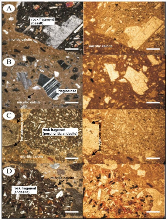
Figure 6.
Microphotographs of samples from the Zengen region: (A) coarse-grained basaltic rock fragments seen within a fine-grained matrix (Z7, cross and single polarized image, scale bar 1 mm); (B) plagioclase and rock fragments within a consolidated fine matrix (Z7, cross and single polarized image, scale bar 1 mm); (C) a relatively coarse-grained volcanic rock fragment within a fine-grained matrix (Z7, cross and single polarized image, scale bar 1 mm); (D) the consolidated matrix consists of clay and micritic calcite. Image of coarse-grained pyroxene, feldspar, mica (biotite), volcanic rock fragments (Z8, cross and single polarized image, scale bar 1 mm).
In the study area of the Altunhisar region, sand levels spread over a wide area were subjected to mineralogical studies, and samples were taken from bottom to top for microscopic investigation (Figure 7). Approximately 47–50% of the samples are volcanic rock fragments, andesites, and basalts. These volcanic rock fragments contain volcanic glass and feldspar minerals. These feldspars comprise about 25–27% and include potassium feldspar and plagioclase. Additionally, there is about 18–22% quartz. Furthermore, 3–5% of the samples contain micritic calcite, and 1–2% contain opaque and other ferromagnesian minerals.
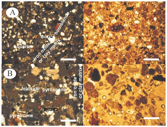
Figure 7.
Microphotographs of samples from the Altunhisar area: (A) andesitic, basaltic rock fragments and volcanic rock fragments. The grains are well rounded, and the minerals are unaltered, bound together by clay and iron oxide (AD1, cross and single polarized image, scale bar 1 mm); (B) Rock fragments with coarse grained feldspars are seen along with small quartz grains, slightly altered feldspar, bound by clay and iron oxide (AD3, cross and single polarized image, scale bar 1 mm).
3.4. XRD Studies
XRD measurements were conducted on samples from the basement rock, and for the ZT2–ZT5 sample, the minerals determined in the phases in the MDI Jade 6.5 are calcite, feldspar, quartz, and clay minerals. The clay minerals are illite, montmorillonite (smectite), sepiolite, chlorite, and palygorskite.
For the Z2 sample of the P1 profile, the minerals determined in the phases in the Jade program are quartz, calcite, and clay minerals. The clay minerals are illite, montmorillonite, and palygorskite, and for the Z3 sample, the minerals are quartz, calcite, hornblende, and clay minerals. The clay minerals are illite and chlorite. For the Z4 sample, the minerals are quartz, calcite, albite, and clay minerals. The clay minerals are illite, montmorillonite, chlorite. For the Z5 sample, the minerals are calcite, quartz, albite, and clay minerals. The clay minerals are montmorillonite, illite, and chlorite. For the Z6 sample, the minerals are calcite, quartz, albite, antigorite, and clay minerals. The clay minerals are montmorillonite, chlorite, and vermiculite (Figure 8). For the Z7 sample, the minerals are calcite, quartz, albite, and clay minerals. The clay minerals are illite, montmorillonite (smectite), chlorite, and vermiculite. For the Z8 sample, the minerals are calcite, quartz, albite, and clay minerals. The clay minerals are illite, palygorskite, montmorillonite (smectite), chlorite, and vermiculite. For the Z9 sample, the minerals are the same as for Z8. For the Z10 sample, the minerals are calcite, quartz, opal-CT, and clay minerals. The clay minerals are montmorillonite (smectite) and chlorite. For the Z11 sample, the minerals are calcite, quartz, albite, and clay minerals. The clay minerals are illite, chlorite, montmorillonite (smectite), and sepiolite. For the Z12 sample, the minerals are quartz, calcite, antigorite, and clay minerals. The clay minerals are illite, sepiolite, and chlorite. Mineral phases were initially identified from the XRD patterns, and the percentage quantities of the same minerals were determined using the SIROQUANT 3.0 software program (see also Figure 8).
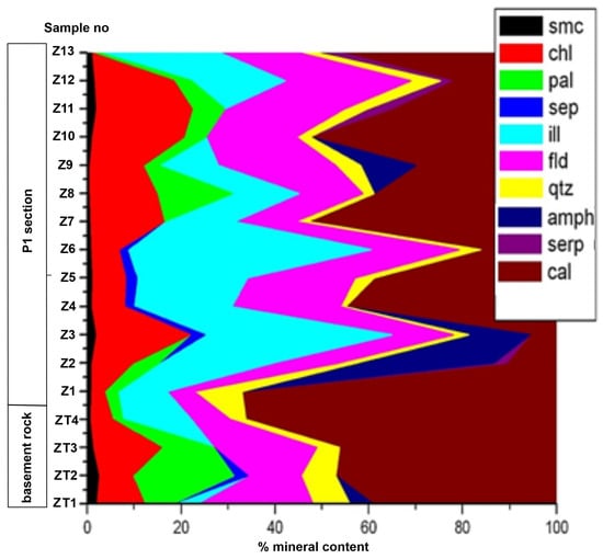
Figure 8.
Graphical representation and vertical distribution in the profile of the quantities of minerals calculated for Zengen region samples ZT1–ZT4 (basement rock, Pliocene) and Z1–Z13 (P1 section, Quaternary), with the help of SIROQUANT output data (smc: smectite; chl: chlorite; pal: palygorskite; sep: sepiolite; ill: illite; fds: feldspar; qtz: quartz; amph: amphibole; serp: serpentine; cal: calcite).
3.5. Geochemical Studies
In the Zengen profile, the amounts of CaO are generally low, reaching up to 50% only in calcrete levels (Figure 9). Paleosols in the Zengen region contain high amounts of SiO2, Fe2O3, and Al2O3. MgO, Na2O, K2O, and P2O5 are some of the levels depleted due to strong weathering. The high values in these zones are due to the presence of minerals such as feldspar and smectite. In calcrete zones, however, the amounts of CaO increase, whereas significant decreases in the amounts of SiO2 are observed. Therefore, a negative correlation between SiO2 and CaO is observed. The high SiO2 contents in this profile are derived from quartz, feldspar, opal-CT, opal A, and clay minerals. The vertical distributions and behaviors of trace elements like Ba, Cu, Zn, Ni, Co, and Sr in the Zengen area profile show variation in the different levels. While the profile presents a positive correlation in heavy metal ratios, some zones are enriched with these heavy metals, and others are depleted. The reason for this is the direct transportation of sediments to the areas where the paleosols formed by flood plain areas or lake shores in the study area. The transported sediments can be enriched with heavy metals.
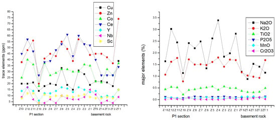
Figure 9.
Distribution of the major elements such as NaO, K2O, TiO2, P2O5, MnO, and Cr2O3 (major elements) (right) and Ba, Ni, Sr, and Zr (trace elements) in samples from the Zengen region (left): ZT1–ZT5 (basement rock, Piliocene) and Z1–Z13 (P1 section, Quaternary).
4. Discussion and Conclusions
The calcrete levels found at the base of locations in the Zengen P1 profile were not found in the Altunhisar (P2) area. This is because parts of the Altunhisar region’s geological structures have been removed and transported away due to alteration and decomposition events by river systems entering the area. Paleosols are generally brown and red, containing volcanic rock fragments and traces of plant roots. Paleosols are divided into two groups: columnar and mature. It has been determined that there is a high degree of decomposition in paleosol levels, indicating that the erosion and sedimentation of paleosols in the region are irregular. Calcretes are notable for their light brown to nearly white colors, massive form, hard protrusions, and layered extensions between paleosol levels. Calcrete contains many magmatic and volcanic rock fragments, with high levels of alteration in calcrete levels. The calcretes in the region are horizontal or nearly horizontal in layering. River and lake sediments are dark grey-black, containing moderately to well-processed rock fragments.
In studies conducted at locations in Altunhisar, the bottom contains a sequence of fine grey gravel and sand, topped by a grey-white pumice fall-out product. On top of this is a layer of light grey sand, over which lies a brown paleosol, and above this paleosol layer is a lighter-colored paleosol and sand level. The base of the units consists of approximately 1 m thick grey-white paleosol and pumice fall-out products. A 2 m thick layer of grey-white pumice fall-out product is directly above this. On top of this level is a dark grey sandstone level, ending with a brown paleosol and sand level. The paleosols in the area are generally grey-brown and well developed.
Petrographic examinations of the P1 profile observed that coarse-grained feldspars and rock fragments are partially decomposed and scattered in the sections. There is a significant presence of coarse-grained clinopyroxenes. Abundant trachytic rock fragments containing flow texture and basaltic and andesitic rock fragments containing interseptal texture are found. The rounded nature of these rock fragments in the thin section suggests they were transported from a distance. Alterations along edges, cracks, and cleavages to clay minerals in coarse-grained feldspars and serpentinization, chlorination, sericitization, and opacification in mafic minerals are observed.
XRD studies on samples of the P1 section from the Zengen region showed that quartz, feldspar, calcite, and clay minerals dominate the profile. In addition, minerals such as amphibolite, pyroxene, and serpentine are present, thought to form due to weathering of alluvial material from volcanic rocks in the wide region (Niğde Metamorphics, Ulukışla group volcano-sedimentary rocks, and Melendizdağ volcano-sedimentary rocks). A clear inverse relationship between calcite and clay minerals is evident. While four P1 section levels of clay mineral enrichment were found, five levels of calcite enrichment were identified, indicating ongoing calcification in the area. In paleosol levels, the enrichment of clay minerals, specifically smectite (montmorillonite), chlorite, and palygorskite, has been determined. At the profile’s basement rocks, the calcite mineral is standard, while feldspar increases towards the upper levels.
In the profile P1 at the locations where the amount of CaCO3 increases, a decrease in SiO2 has been identified. Changes in Al2O3 amounts have been detected due to the formation of clay minerals, with no significant change in Fe2O3 and MgO ratios. No significant change in Cr2O3, MnO, and P2O5 amounts has been detected, with changes in TiO2 due to clay mineral formation. There is an increase in NaO and K2O amounts compared to the rocks at the basement rocks, indicating salinization of the area. Changes in rare earth elements and trace elements are observed due to the formation of clay minerals. Mainly, an increase in Sr and Ba towards the upper levels of the profile has been determined. Clay formation or carbonate accumulation can explain the change in Ni and Zr.
The amount of CaCO3 particularly reaches up to about 50% in the basement rock of the P1 profile. In paleosol levels of the profile, the amount of CaCO3 is not rich. Paleosol binders have been determined to consist of clay and iron oxide minerals and a small amount of carbonate.
The results presented above regarding the Bor–Ereğli Plain when compared with studies conducted on the Quaternary fill of the Konya Basin by [18,19] indicate that the region has undergone a long-term hydrological evolution; they have determined this by examining various landforms, alluvial materials, and lacustrine sediments. The examination of terrestrial sediments taken from the study area confirms the works of [18,19]. In the studies conducted by [18,30], it is stated that after 17,000 years ago, no lacustrine phase reached a level above the periglacial lake level in the region, reaching this level with the melting of the Melendizdağ, Bolkar, and Aladağ (Central Taurus) ice sheets. The melting of the glaciers led to an increase in the number and speed of river systems feeding the Bor–Ereğli basin. The information obtained from examining sediments taken from river levels in this study conducted in the Altunhisar area confirms these findings.
During the late glacial period, shallow fresh water lacustrine phases and paleosols were identified from 12,500 to 11,000 yr BP in the Bor Basin. These deposits are comparable in age to those in the Çiftlik Basin [31,32] and thus support the interpretation of change in glacial conditions, as supported by a clay mineralogical analysis, in the sediments of its fluvial lacustrine and paleosol successions [32].
The Pleistocene–Holocene transition (late glacial) led to the formation of lime-rich muds, and the extreme rise in temperatures during the Holocene period resulted in the formation of CaCO3 precipitates (calcrete levels). It has been stated by [18,30] that paleosols developed during geologically calm periods within this period. The studies we conducted in the Zengen region, with CaCO3 accumulations and paleosol levels having horizontal or nearly horizontal alteration surfaces, confirm the findings of [18,19]. Our findings are similar to the situation reported by [18,19] in the Konya Plain, Central Turkey.
Author Contributions
Conceptualization, A.G.; methodology, A.S. and A.G.; software, A.S. and A.G.; validation, A.S. and A.G.; formal analysis, A.S. and A.G.; investigation, A.S. and A.G.; resources, A.S. and A.G.; data curation, A.S. and A.G.; writing—original draft preparation, A.S. and A.G.; writing—review and editing, A.S. and A.G.; visualization, A.S. and A.G.; supervision, A.S. and A.G.; project administration, A.G.; funding acquisition, A.S. and A.G. All authors have read and agreed to the published version of the manuscript.
Funding
This research was funded by Niğde University grant number BAP-FEB project number 2010/13. This study was produced from a master’s thesis prepared under the supervision of Ali GÜREL (Niğde University, Department of Geological Engineering).
Data Availability Statement
Data are contained within the article.
Conflicts of Interest
The authors declare no conflicts of interest.
References
- Göncüoğlu, M.C. Niğde Masifinin Jeolojisi, İç Anadolunun Jeolojisi Sempozyumu; TJK Yayını: Ankara, Türkiye, 1981. [Google Scholar]
- Parlak, O.; Höck, V.; Delaloye, M. Suprasubduction zone origin of the Pozanti-Karsanti ophiolite (southern Turkey) deduced from whole-rock and mineral chemistry of the gabbroic cumulates. Geol. Soc. Lond. Spec. Publ. 2000, 173, 219–234. [Google Scholar] [CrossRef]
- Sarıfakıoğlu, E.; Dilek, Y.; Winchester, J.A. Late Cretaceous subduction initiation and Palaeocene–Eocene slab breakoff magmatism in south-central Anatolia, Turkey. Int. Geol. Rev. 2013, 55, 66–87. [Google Scholar] [CrossRef]
- Oktay, F.Y. Stratigraphy and geological evolution of Ulukişla and its surroundings. Bull. Geol. Soc. Turk. 1982, 25, 15–23. [Google Scholar]
- Nazik, A.; Gökçen, N. Stratigraphical Interpretation of the Ulukışla Tertiary Sequences by Ostracodes and Foraminifers. Geol. Bull. Turk. 1989, 32, 89–99. [Google Scholar]
- Toprak, V. Vent distribution and its relation to regional tectonics, Cappadocian Volcanics, Turkey. J. Volcanol. Geotherm. Res. 1998, 85, 55–67. [Google Scholar] [CrossRef]
- Göncüoğlu, M.C.; Toprak, V. Neogene and Ouaternary vocanism of central Anatolia: A volcano-structural evaluation. Bull. Sect. Volcanol. Soc. Géol. Fr. 1992, 26, 1–6. [Google Scholar]
- Beekman, P.H. The Pliocene and Quarternary volcanism in The Hasandağ-Melendizdağ Region. MTA Bull. 1966, 66, 99–106. [Google Scholar]
- Pasquare, G. Geologie of the Senozoic volkanic area of Central Anatolia; Atti Della Acad. No. Delince Menorie Serie; Accademia Nazionale dei Lincei: Rome, Italy, 1968; Volume 9, pp. 55–204. [Google Scholar]
- Dönmez, M.; Türkecan, A.; Akçay, E.A. Kayseri-Niğde-Nevşehir Yöresi Tersiyer Volkanikleri Raporu; Maden Tetkik ve Arama Genel Müdürlüğü Rapor No: 10575; MTA: Ankara, Türkiye, 2003. [Google Scholar]
- Goz, E.; Kadir, S.; Gurel, A.; Eren, M. Geology, mineralogy, geochemistry and depositional environment of Late Miocene/Pliocene fluvial-lacustrine succession, Cappadocia Volcanic Provenance, Central Anatolia, Turkey. Turk. J. Earth Sci. 2014, 23, 386–411. [Google Scholar] [CrossRef]
- Lepetit, P.; Viereck, L.; Piper John, D.A.; Sudo, M.; Gürel, A.; Çopuroğlu, İ.; Gruber, M.; Mayer, B.; Koch, M.; Tatar, O. 40Ar/39Ar dating of ignimbrites and plinian air-fall layers from Cappadocia, Central Turkey: Implications to chronostratigraphic and Eastern Mediterranean palaeoenvironmental record. Geochemistry 2014, 74, 471–488. [Google Scholar] [CrossRef]
- Gürel, A. Geology, mineralogy, and geochemistry of late Miocene paleosol and calcrete in the western part of the Central Anatolian Volcanic Province (CAVP), Turkey. Geoderma 2017, 302, 22–38. [Google Scholar] [CrossRef]
- Yıldız, A.; Gürel, A. Diyatom community and palaeoenvironmental interpretation of Pleistocene-Holocene lacustrine diyatomite deposits in the Çiftlik Basin (Niğde, Central Anatolia, Turkey). In Proceedings of the 12th RCMNS Congress, Vienna, Austria, 6–11 September 2005; p. 82. [Google Scholar]
- Gürel, A.; Yıldız, A. Diyatom communities, lithofacies characteristics and paleo-environmental interpretation of Pliocene diyatomite deposits in the Ihlara-Selime plain (Aksaray, Central Anatolia, Turkey). J. Asian Earth Sci. 2006, 30, 170–180. [Google Scholar] [CrossRef]
- Gülenbay, A. Ereğli-Bor Ovası Hidrojeolojik Etüd Raporu; DSİ yayınları: Ankara, Türkiye, 1972; p. 71. [Google Scholar]
- Müller, G.; Irion, G.; Förstner, U. Formation and diagenesis of inorganic Ca–Mg carbonates in the lacustrine environment. Naturwissenschaften 1972, 59, 158–164. [Google Scholar] [CrossRef]
- Kuzucuoglu, C.; Karabiyikoglu, M.; Fontugne, M.; Pastre, J.-F.; Ercan, T. Environmental changes in Holocene lacustrine sequences from Karapinar in the Konya plain (Turkey). In Third Millenium BC Social Collapse and Climate Change; Dalfes, N., Kukla, G., Weiss, H., Eds.; NATO ASI Series; Springer: Berlin/Heidelberg, Germany, 1997; Volume 49, pp. 451–463. [Google Scholar]
- Roberts, N.; Black, S.; Boyer, P.; Eastwood, W.; Griffiths, H.I.; Lamb, H.F.; Leng, M.J.; Parish, R.; Reed, J.M.; Twigg, D.; et al. Chronology and stratigraphy of Late Quaternary sediments in the Konya Basin, Turkey: Results from the KOPAL Project. Quat. Sci. Rev. 1999, 18, 610–630. [Google Scholar] [CrossRef]
- Inoue, K.; Saito, M.; Naruse, T. Physicochemical, mineralogical, and geochemical characteristics of lacustrine sediments of the Konya Basin, Turkey, and their significance in relation to climatic change. Geomorphology 1998, 23, 229–243. [Google Scholar] [CrossRef]
- Afşin, M.; Canik, B.; Notsu, K. Farklı dolaşım sistemli sıcak ve mineralli suların hidrojeokimyası: Dertalan, Kemerhisar ve Çiftehan (Niğde) kaynakları. In Proceedings of the Türkiye Petrol Jeologları Derneği Bülteni (TPJD) Haymana-Tuzgölü-Ulukışla Basenlerinin Uygulamalı Çalışması (Workshop), Aksaray, Türkiye, 9–11 October 2003; pp. 149–160. [Google Scholar]
- Gürel, A.; Lermi, A. Pleistocene-Holocene Fills of the Bor-Ereğli Plain (Central Anatolia): Recent Geo-Archaeological Contributions. In Geoarchaeological Activities in Southern Capadocia, Turkey; d’Alfonso, L., Balza, M.E., Mora, C., Eds.; The University of Pavia: Pavia, Italy, 2010; pp. 55–70. [Google Scholar]
- Göncüoğlu, M.C. Geologie des Westlichen Niğde Massivs. Ph.D. Thesis, The University of Bonn, Bonn, Germany, 1977; p. 181. [Google Scholar]
- Göncüoğlu, M.C. Niğde Masifi paragnayslarında zirkon U/Pb yaşları. Türk. Jeol. Kurumu Bül. 1982, 25, 61–66. [Google Scholar]
- Göncüoğlu, M.C. Niğde Masifi Batı Yarısının Jeolojisi; MTA Bölge Müd. Rapor No: 745; MTA: Konya, Türkiye, 1985. [Google Scholar]
- Göncüoğlu, M.C. Orta Anadolu Masifinin güney ucundan jeokronolojik yaş bulguları. MTA Derg. 1986, 105–106, 111–124. [Google Scholar]
- Ulu, Ü.; Bulduk, A.K.; Ekmekçi, E.; Karakaş, M.; Öcal, H.; Arbas, A.; Şaçlı, L.; Taşkıran, M.A.; Adır, M.; Sözeri, Ş. İnlice-Akkise ve Cihanbeyli-Karapınar Alanının Jeolojisi; MTA Der. Rap. No: 9720; MTA: Ankara, Türkiye, 1994. [Google Scholar]
- Blumenthal, M. Yüksek Bolkardağın Kuzey Kenarı Bölgelerinin ve Batı Uzantılarının Jeolojisi; No. 7; Seri D; MTA: Ankara, Türkiye, 1956; p. 153. [Google Scholar]
- Walker, R.G. Nondeltaic depositional environments in the Catskill clastic wedge (Upper Devonian) of central Pennsylvania. Bull. Geol. Soc. Am. 1971, 82, 1305–1326. [Google Scholar] [CrossRef]
- Roberts, N. Age, paleoenvironments, and climatic significance of late Pleistocene Konya Lake, Turkey. Quat. Res. 1983, 19, 154–171. [Google Scholar] [CrossRef]
- Kuzucuoğlu, C.; Gürel, A.; Demir, M.; Çakıcı, Ş.; Dumoulin, J.P. Hydrogeomorphological records of climate changes during the Bronze and Iron Ages in the Bor Plain (central Anatolia). In Ancient Western Asia Beyond the Paradigm of Collapse and Regeneration (1200–900 BCE); Institute for the Study of the Ancient World, New York University Press: New York, NY, USA, 2024; pp. 39–84. [Google Scholar]
- Gürel, A. Geology, mineralogy and geochemistry of Pleistocene-Holocene deposits in the Ciftlik Basin (Nigde) (Central Turkey). Neues Jahrb. Geol. Palaontol.-Abh. 2016, 280, 153–176. [Google Scholar] [CrossRef]
Disclaimer/Publisher’s Note: The statements, opinions and data contained in all publications are solely those of the individual author(s) and contributor(s) and not of MDPI and/or the editor(s). MDPI and/or the editor(s) disclaim responsibility for any injury to people or property resulting from any ideas, methods, instructions or products referred to in the content. |
© 2024 by the authors. Licensee MDPI, Basel, Switzerland. This article is an open access article distributed under the terms and conditions of the Creative Commons Attribution (CC BY) license (https://creativecommons.org/licenses/by/4.0/).