

Holocene Paleohydrological Changes Reflected in Lake-Level Fluctuations in Lake Annecy (French Pre-Alps): Climatic Significance and Archeological Implications

Abstract
1. Introduction
2. Site and Methods
2.1. Lake Annecy
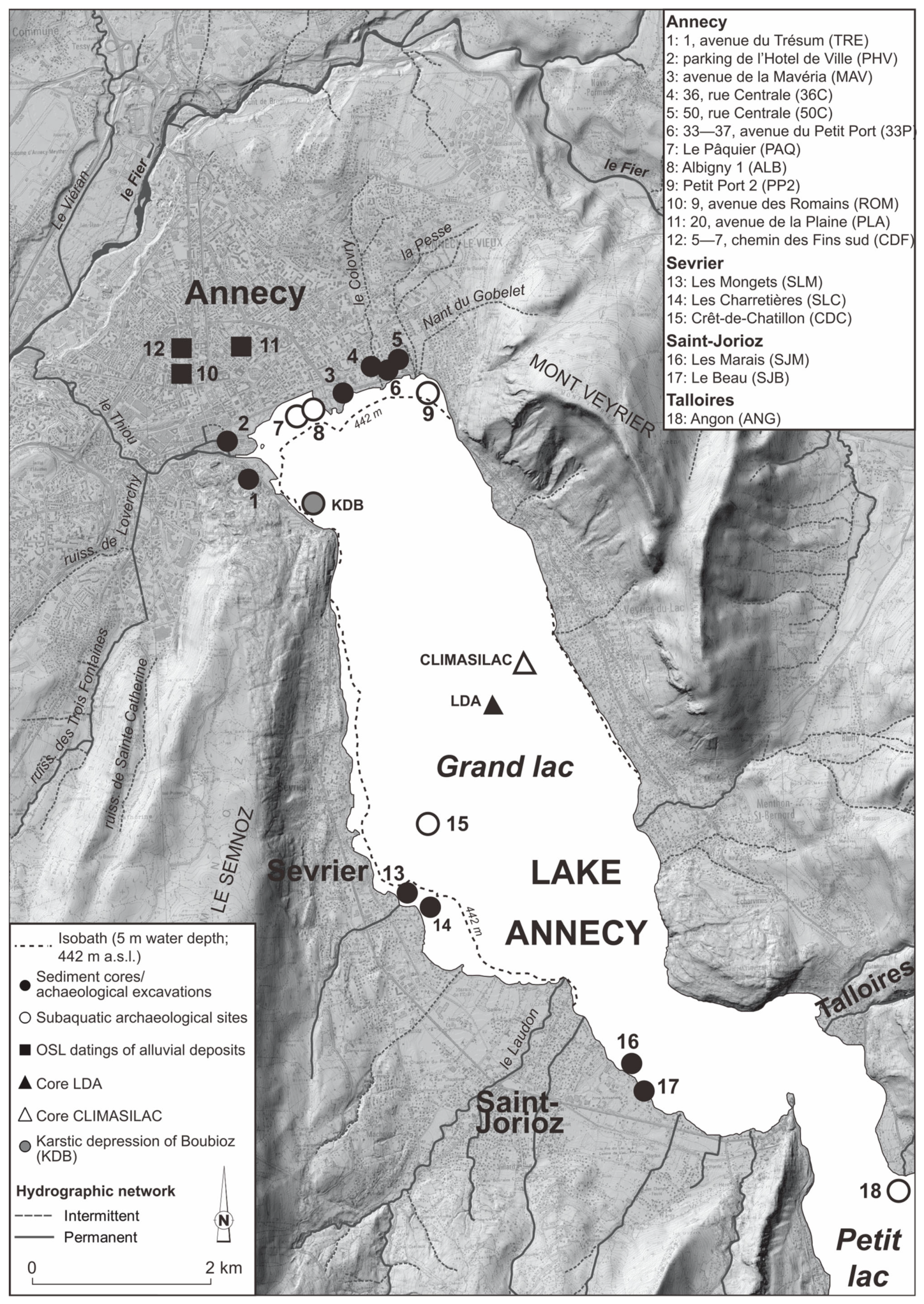
2.2. Study Sites
2.3. Methods
- -
- Changes in the sediment texture: Coarser deposits correspond to near-shore areas (with shallower water and higher hydrodynamism).
- -
- Changes in the lithology: Organic deposits (detritus gyttja containing terrestrial macrorests from the vegetation of the littoral mires and more or less carbonate silt and peat) often characterize the shallower water or late stages of infillings (shallow residual basins). Carbonate lake marl is found in the deeper water [2,26,27,28,29].
- -
- Changes in the assemblages of carbonate concretions: The coarser fraction (>0.2 mm) of the lake marl consists mainly of different morphotypes of carbonate concretions of biochemical origin. Modern analogs show that each morphotype has a specific spatial depth distribution from the shore to the extremity of the littoral platform in association with the hydrodynamics and belts of aquatic vegetation. Oncoliths characterize the nearshore areas with high-energy environments [30].
- -
- Sediment hiatuses: These indicate either erosion or a lack of deposition. They result from a lowering of the sediment limit due to the lowering of the lake level [2,31]. They are marked by unconformities between sediment layers and are identified from core transects perpendicular to the shore, as well as from pollen analyses.
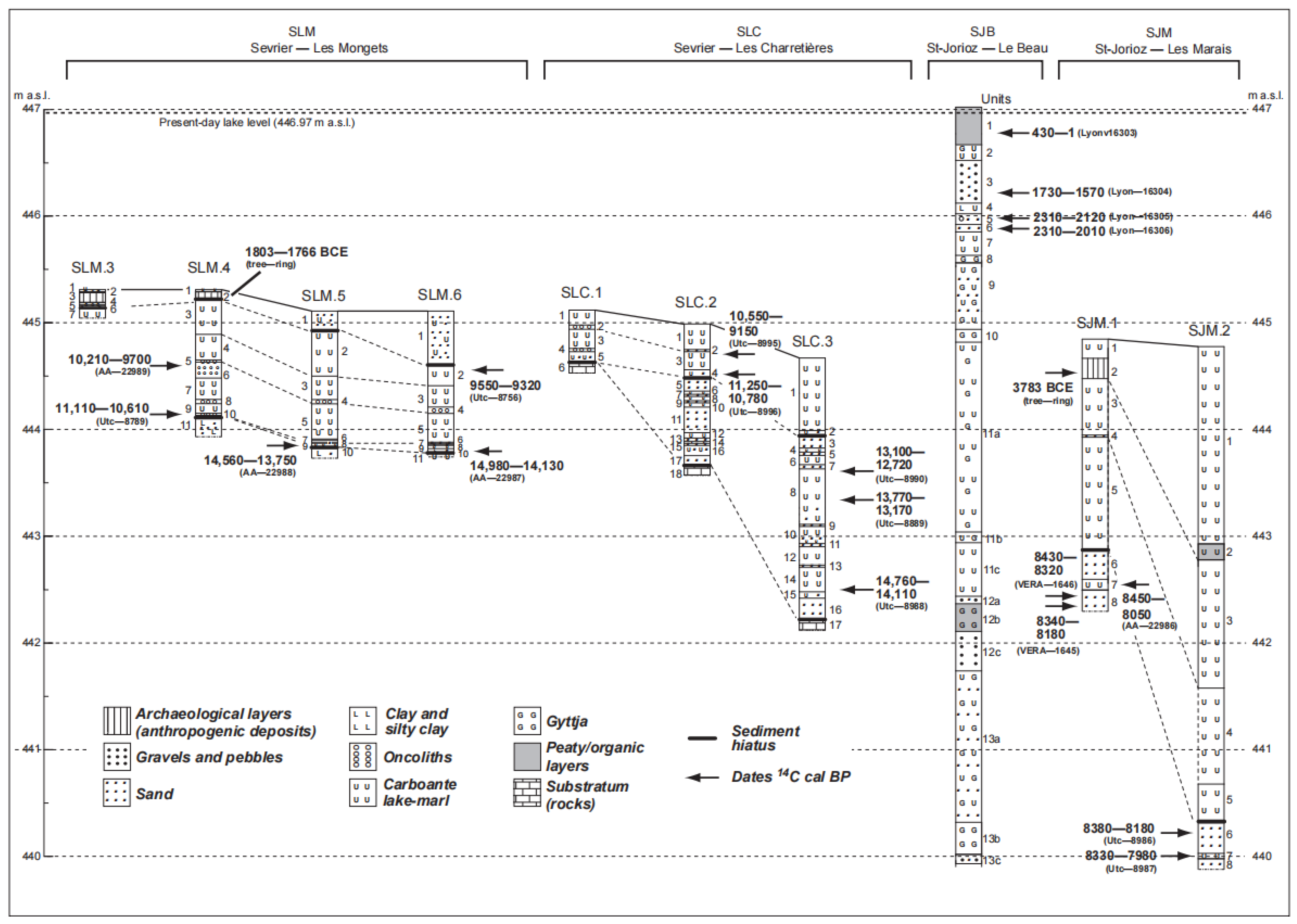
3. Results
- -
- The first (phase 8) was well radiocarbon dated to 8300–8200 cal BP at the site of Saint-Jorioz Les Marais;
- -
- The second (phase 10) was recorded in sediment unit 13a at Saint-Jorioz Le Beau, where unit 12 corresponded to lake-level phase 11.
4. Discussion and Conclusions
4.1. Time Windows Needing Further Investigations
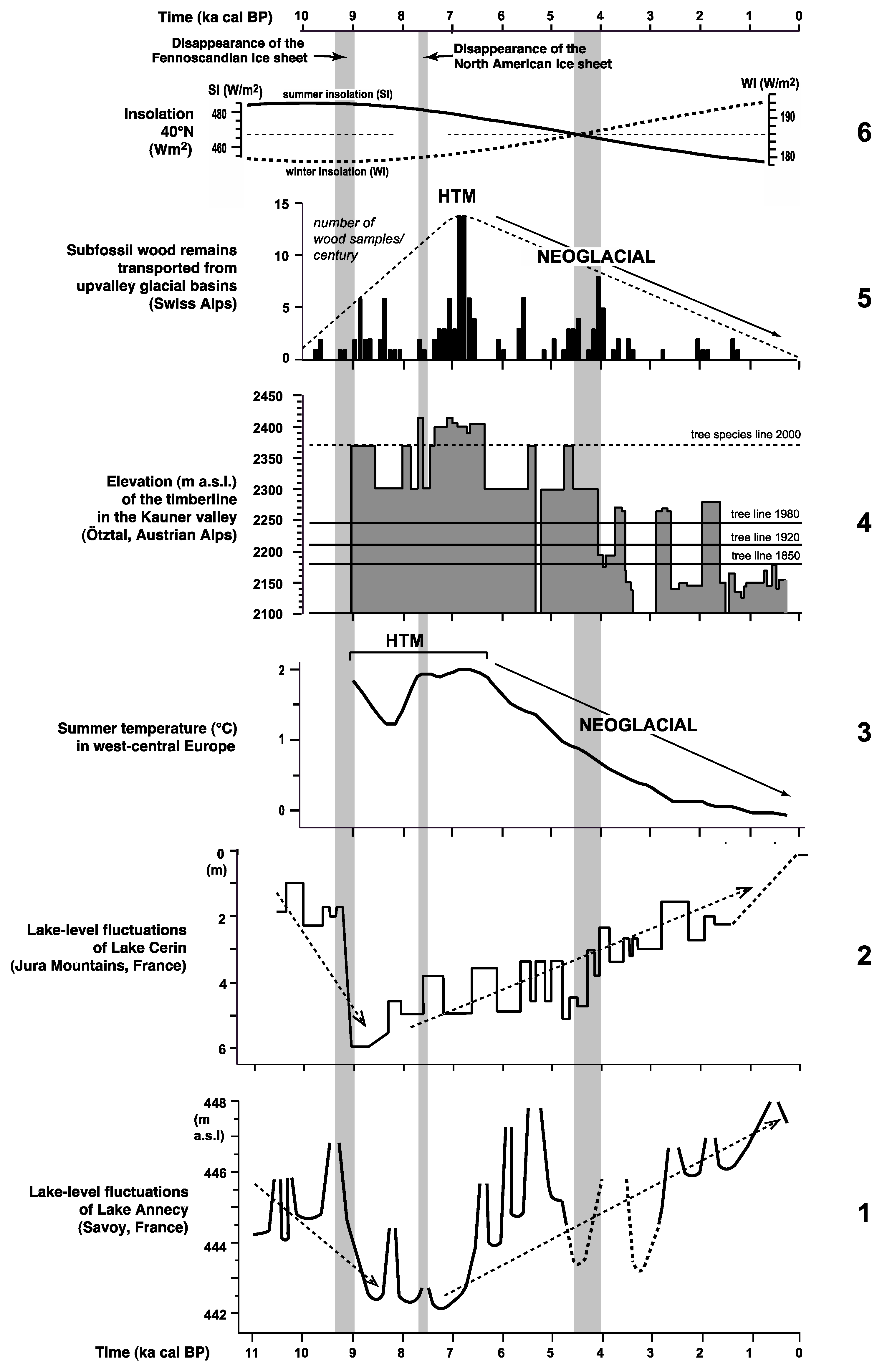
4.2. Millennial Lake-Level Fluctuations
4.3. Multi-Centennial Lake-Level Fluctuations
4.3.1. The Period of 11,700–9000 cal BP
4.3.2. The Period of 9000–7000 cal BP
4.3.3. The Period of 7000–5000 cal BP
4.3.4. The Period of 5000–2700 cal BP
4.3.5. The Last 2700 Years
4.4. Lake-Level Fluctuations, Climate Changes, and Seismic Events
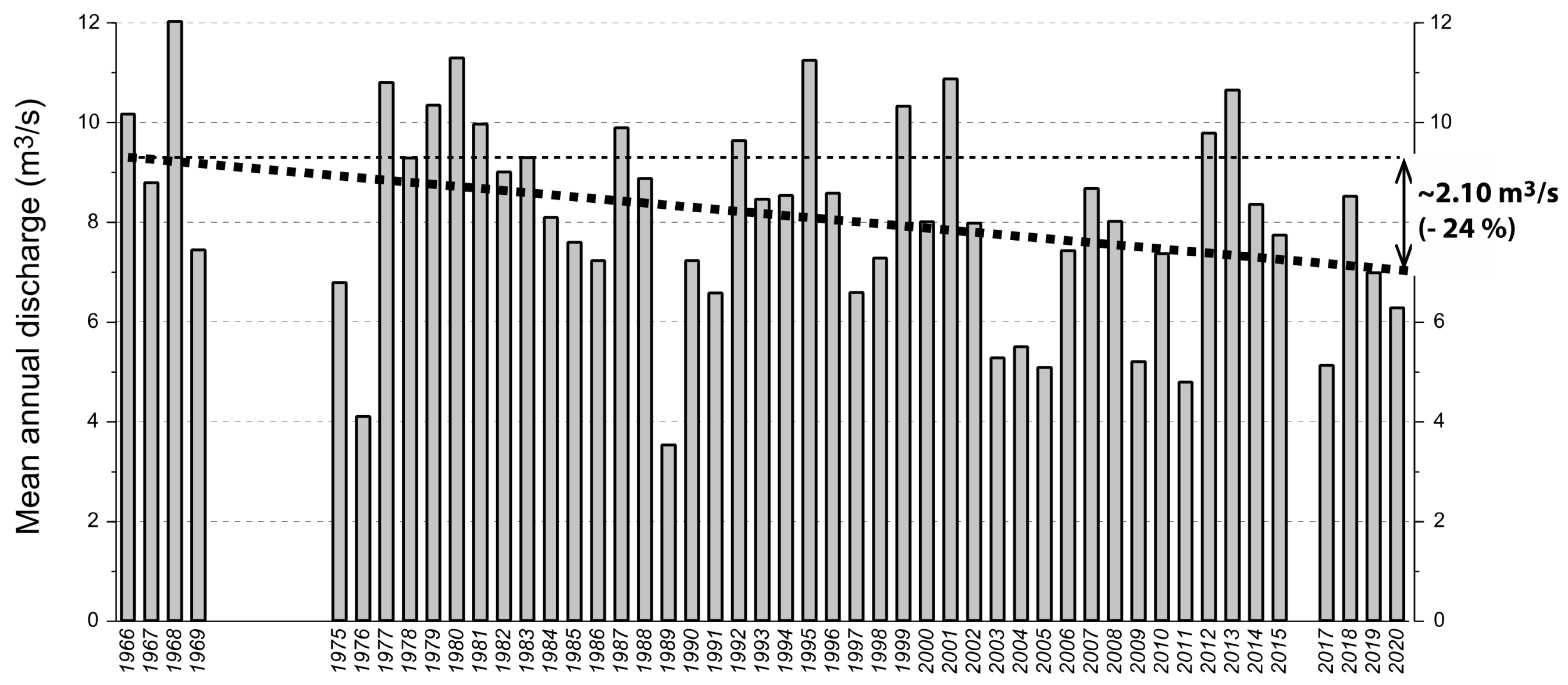
4.5. The Present-Day Climate Warming
Author Contributions
Funding
Data Availability Statement
Acknowledgments
Conflicts of Interest
References
- Yao, F.; Livneh, B.; Rajagopalan, B.; Wang, J.; Crétaux, J.F.; Wada, Y.; Berge-Nguyen, M. Satellites reveal widespread decline in global lake water storage. Science 2023, 380, 743–749. [Google Scholar] [CrossRef] [PubMed]
- Digerfeldt, G. Reconstruction and regional correlation of Holocene lake-level fluctuations in lake Bysjön, South Sweden. Boreas 1988, 17, 165–182. [Google Scholar] [CrossRef]
- Van Rensbergen, P.M.; De Batist, M.; Beck, C.; Manalt, F. High-resolution seismic stratigraphy of Late Quaternary of Lake Annecy (northwestern Alps): Evolution from full glacial to interglacial sedimentary processes. Sedim. Geol. 2001, 117, 71–96. [Google Scholar] [CrossRef]
- Nicoud, G.; Manalt, F. The lacustrine depression at Annecy (France), geological setting and Quaternary evolution. J. Paleolim. 2001, 25, 137–147. [Google Scholar] [CrossRef]
- Beck, C.; Van Rensbergen, P.; De Batist, M.; Berthier, F.; Lallier, S.; Manalt, F. The Late Quaternary sedimentary infill of Lake Annecy (northwestern Alps): An overview from two seismic-reflection surveys. J. Paleolim. 2001, 25, 149–161. [Google Scholar] [CrossRef]
- Oldfield, F.; Berthier, F. The multi-proxy late Pleistocene and Holocene record from the sediments of the Grand Lac d’Annecy, eastern France. J. Paleolim. 2001, 25, 133–135. [Google Scholar] [CrossRef]
- Higgitt, S.R.; Oldfield, F.; Appleby, P.G. The record of land use change and soil erosion in the late Holocene sediments of the Petit Lac d’Annecy, eastern France. Holocene 1991, 1, 14–28. [Google Scholar] [CrossRef]
- Jones, R.T.; Reinhardt, L.J.; Dearing, J.A.; Crook, D.; Chiverrell, R.C.; Welsh, K.E.; Verges, E. Detecting climatic signals in an anthropogenically disturbed catchment: The late-Holocene record from the Petit Lac d’Annecy, French Alps. Holocene 2013, 23, 1329–1339. [Google Scholar] [CrossRef]
- David, F.; Farjanel, G.; Jolly, M.P. Palyno- and chronostratigraphy of a long sequence from Lac Annecy (northern outer Alps, France). J. Paleolim. 2001, 25, 259–269. [Google Scholar] [CrossRef]
- SILA (Syndicat Intercommunal du Lac d’Annecy). Etude écologique Relative au Rétablissement d’un Marnage sur le lac d’Annecy; SILA (Syndicat Intercommunal du Lac d’Annecy): Cran-Gevrier, France, 2011; 223p. [Google Scholar]
- Vérot, A.; Magny, M.; Morin, E.; Brigand, R.; Richard, H.; Marguet, A.; Gabayet, F.; Hinschberger, F.; Mevel, L. Paléoenvironnement et Archéologie de la Rive nord du lac d’Annecy à Annecy et Annecy-le-Vieux (Haute-Savoie); Rapport de synthèse du PCR 2016–2020; DRAC Auvergne-Rhône-Alpes: Lyon, France, 2021; Volume 2, 440p. [Google Scholar]
- Magny, M. Palaeohydrological changes as reflected by lake-level fluctuations in the Swiss Plateau, the Jura Mountains and the northern French Pre-Alps during the Last Glacial-Holocene transition: A regional synthesis. Glob. Planet. Chang. 2001, 30, 85–101. [Google Scholar] [CrossRef]
- Magny, M.; Marguet, A.; Richard, H.; Billaud, Y. Early and late Holocene water-level fluctuations of Lake Annecy, France: Sediment and pollen evidence and climatic implications. J. Paleolim. 2001, 25, 215–227. [Google Scholar] [CrossRef]
- Magny, M.; Bégeot, C.; Guiot, J.; Marguet, A.; Billaud, Y. Reconstruction and palaeoclimatic interpretation of mid-Holocene vegetation and lake-level changes at Saint-Jorioz, Lake Annecy, French Pre-Alps. Holocene 2003, 13, 265–275. [Google Scholar] [CrossRef]
- Magny, M.; Vérot, A.; Morin, E.; Richard, H.; Hinschberger, F.; Marguet, A.; Brigand, R.; Gabayet, F. Variations du niveau du lac d’Annecy (Haute-Savoie, France) au cours de l’Holocène: Implications paléoclimatiques et archéologiques. Quaternaire 2022, 33, 169–192. [Google Scholar] [CrossRef]
- Marguet, A. 2002—Haute-Savoie, lac d’Annecy. Elaboration de la carte archéologique des gisements du lac d’Annecy. In Bilan Scientifique 2001; Ministère de la Culture, Ed.; Département des Recherches Archéologiques Subaquatiques et Sous-Marines: Paris, France, 2002; pp. 116–130. [Google Scholar]
- Marguet, A. Haute-Savoie, lac d’Annecy. Mise à jour de la carte archéologique des gisements du lac d’Annecy. In Bilan Scientifique 2002; Ministère de la Culture, Ed.; Département des Recherches Archéologiques Subaquatiques et Sous-Marines: Paris, France, 2003; pp. 119–125. [Google Scholar]
- Billaud, Y.; Marguet, A. Habitats lacustres du Néolithique et de l’Age du Bronze dans les lacs alpins français: Bilan des connaissances et perspectives. In Wetland Economies and Societies, Proceedings of the International Conference in Zürich, Switzerland, 10–13 March 2004; Della Casa, P., Trachsel, M., Eds.; Chronos Verlag, Collectio Archaeologica: Zürich, Switzerland, 2005; Volume 3, pp. 169–178. [Google Scholar]
- Marguet, A.; Rey, P.-J. Le Néolithique dans les lacs alpins français: Un catalogue actualisé. Cah. D’archéologie Rom. 2007, 108, 379–406. [Google Scholar]
- Rey, P.-J.; Marguet, A. L’occupation du territoire en Savoie et Haute-Savoie au Néolithique. Bull. D’études Préhistoriques Et Archéologiques Alp. 2019, 29–30, 57–80. [Google Scholar]
- Billaud, Y.; Brigand, R.; Raffin, M.; Subtil, M. Suivi des Stations Palafittiques Savoyardes Inscrites au Patrimoine Mondial de l’Unesco, Campagne 2016: Bilan Documentaire; Prospection Thématique Subaquatique lac d’Aiguebelette (Savoie) et lac d’Annecy (Haute-Savoie); DRASSM: Marseille, France, 2017. [Google Scholar]
- Billaud, Y. Le Crêt de Chatillon–Sévrier, Lac d’Annecy. Monitoring et récentes campagnes de terrain sur un site insulaire du Bronze final. Palafittes/Pfahlbauten/Palafitte/Kolišča/Pile Dwellings NEWS 2020, 1, 40–45. [Google Scholar]
- Brigand, R.; Billaud, Y. Le Néolithique des lacs savoyards: État des lieux et mise en perspective des prospections récentes. In Statut des Objets, des lieux et des Hommes au Néolithique; Fromont, N., Marchand, G., Forré, P., Eds.; Actes du 32e colloque InterNéo (Octobre 2017); Presses Chauvinoises: Le Mans, France, 2021; pp. 455–470. [Google Scholar]
- Brigand, R. Prospection aérienne et télédétection en archéologie lacustre: Les palafittes néolithiques de la baie d’Annecy. Bull. De La Société Préhistorique Française 2021, 118, 400–404. [Google Scholar]
- Magny, M. Holocene climatic variability as reflected by mid-European lake-level fluctuations, and its probable impact on prehistoric human settlements. Quat. Intern. 2004, 113, 65–79. [Google Scholar] [CrossRef]
- Magny, M. Holocene fluctuations of lake levels in west-central Europe: Methods of reconstruction, regional pattern, palaeoclimatic significance and forcing factors. In Encyclopedia of Quaternary Geology; Elias, S., Ed.; Elsevier: Amsterdam, The Netherlands, 2006; pp. 1389–1399. [Google Scholar]
- Magny, M. Orbital, ice-sheet and possible solar forcing of Holocene lake-level fluctuations in west-central Europe: A comment on Bleicher. Holocene 2013, 23, 1202–1212. [Google Scholar] [CrossRef]
- Faegri, K.; Iversen, J. Textbook of Pollen Analysis; Hafner Publishing Co.: New York, NY, USA, 1964; 237p. [Google Scholar]
- Troels-Smith, J. Characterization of Unconsolidated Sediments; C.A. Reitzels Forlag Axel Sandal: Copenhague, Denmark, 1955; 99p. [Google Scholar]
- Brochier, J.-L. La baie d’Auvernier, lac de Neuchâtel, Suisse: Evolution paléolimnologique et habitats préhistoriques d’après l’étude des séquences sédimentaires; Rapport, Musée cantonal d’Archéologie: Neuchâtel, Switzerland, 1986; 83p. [Google Scholar]
- Digerfeldt, G. Studies on past lake-level fluctuations. In Handbook of Holocene Palaeoecology and Palaeohydrology; Berglund, B.E., Ed.; John Wiley and Sons: New York, NY, USA, 1986; pp. 127–143. [Google Scholar]
- Stuiver, M.; Reimer, P.J. Extended 14C database and revised CALIB radiocarbon calibration program. Radiocarbon 1993, 35, 215–230. [Google Scholar] [CrossRef]
- Reimer, P.J.; Bard, E.; Bayliss, A.; Beck, J.W.; Blackwell, P.G.; Ramsey, C.B.; Buck, C.E.; Cheng, H.; Edwards, R.L.; Friedrich, M.; et al. Intcal 13 and Marine 13 Radiocarbon age calibration curves 0–50,000 years cal BP. Radiocarbon 2013, 55, 1869–1887. [Google Scholar] [CrossRef]
- Galbraith, R.F.; Roberts, R.G.; Laslett, G.M.; Yoshida, H.; Olley, J.M. Optical dating of single and multiple grains of quartz from Jinmium Rock Shelter, northern Australia: Part I, experimental design and statistical models. Archaeometry 1999, 41, 339–364. [Google Scholar] [CrossRef]
- De Beaulieu, J.-L.; Richard, H.; Ruffaldi, P.; Clerc, J. History of vegetation, climate and human action in the French Alps and the Jura over the last 15000 years. Dissert. Botan. 1994, 234, 253–276. [Google Scholar]
- Nomade, J. Chronologie et sédimentologie du remplissage du lac d’Annecy depuis le Tardiglaciaire: Implications paléoclimatologiques et paléohydrologiques. Ph.D. Thesis, University Joseph Fourier, Grenoble, France, 2005; 357p. [Google Scholar]
- Hafner, A. Archaeological discoveries on Schnidejoch and at other ice sites in the European Alps. Arctic 2012, 65, 189–202. [Google Scholar] [CrossRef]
- Magny, M.; Haas, J.N. A widespread climatic change around 5300 cal yr BP at the time of the Alpine Iceman. J. Quat. Sci. 2004, 19, 423–430. [Google Scholar] [CrossRef]
- Magny, M.; Bossuet, G.; Ruffaldi, P.; Leroux, A.; Mouthon, J. Orbital imprint on Holocene palaeohydrological variations in west-central Europe as reflected by lake-level changes at Cerin (Jura Mountains, eastern France). J. Quat. Sci. 2011, 26, 171–177. [Google Scholar] [CrossRef]
- Nicolussi, K.; Kaufmann, M.; Patzelt, G.; Van der Plicht, J.; Thurner, A. Holocene treeline variability in the Kauner Valley, Central Eastern Alps, indicated by dendrochronological analysis of living trees and subfossils logs. Veg. Hist. Archaeobot. 2005, 14, 221–234. [Google Scholar] [CrossRef]
- Joerin, U.E.; Stocker, T.F.; Schlüchter, C. Multicentury glacier fluctuations in the Swiss Alps during the Holocene. Holocene 2006, 16, 697–704. [Google Scholar] [CrossRef]
- Renssen, H.; Seppä, H.; Heiri, O.; Roche, D.; Goosse, H.; Fichefet, T. The spatial and temporal complexity of the Holocene thermal maximum. Nat. Geosci. 2009, 2, 411–414. [Google Scholar] [CrossRef]
- Berger, A.; Loutre, M.F. Insolation values for the climate of the last 10 million of years. Quat. Sci. Rev. 1991, 10, 297–317. [Google Scholar] [CrossRef]
- Ivy-Ochs, S.; Kerschner, H.; Maisch, M.; Christle, M. Latest Pleistocene and Holocene glacier variations in the European Alps. Quat. Sci. Rev. 2009, 28, 2137–2149. [Google Scholar] [CrossRef]
- Johnsen, S.J.; Dahl-Jensen, D.; Gundestrup, N.; Hateffensen, J.P. Oxygen isotope and paleotemperature records from six Greenland ice-core stations: Camp Century, Dye-3, GRIP, GISP2, Renland and NorthGRIP. J. Quat. Sci. 2001, 16, 299–307. [Google Scholar] [CrossRef]
- Zhang, W.; Dawes, R.; Walker, G.R. Response of mean annual evapostranspiration to vegetation changes at catchment scale. Water Resour. Res. 2001, 37, 701–708. [Google Scholar] [CrossRef]
- Steiner, H. Brücken statt Barrieren, Südtiroler Passagen. Z. Archäologie Dtschl. 2021, 21, 22–27. [Google Scholar]
- Hafner, A. (Ed.) Schnidejoch und Lötschenpass. Archäologische Forschungen in de Berner Alpen; Band 1 und 2. Archäologischer Dienst des Kantons Bern und Dienststelle für Hochbau; Denkmalpflege und Archäologie des Kantons Wallis: Bern, Switzerland, 2015. [Google Scholar]
- Botti, V.; Tutino, S.; Paldin, A.; Samadelli, M.A. Mummified marmot at 4.300 meters: The Efisio Noussan Regional Museum of Natural Sciences takes care of its recovery, conservation, and laboratory investigations. In Proceedings of the 30th Congresso ANMS–Musei Scientifici, Ambiente, Territorio, Nuove Visioni, Obiettivi, Servizi, Relazioni per Comunità Sostenibili, Aosta, Italy, 18–21 October 2022. [Google Scholar]
- Cornelissen, M.; Auf der Maur, C.; Reitmaier, T. A glacially preserved Mesolithic rock crystal extraction site in the Swiss Alps. Norwegian Archaeol. Rev. 2022, 55, 96–102. [Google Scholar] [CrossRef]
- Teller, J.T.; Leverington, D.W.; Mann, J.D. Freshwater outbursts to the oceans from glacial Lake Agassiz and their role in climate change during the last deglaciation. Quat. Sci. Rev. 2002, 21, 879–887. [Google Scholar] [CrossRef]
- Magny, M.; Bégeot, C. Hydrological changes in the European midlatitudes associated with freshwater outbursts from Lake Agassiz during the Younger Dryas event and the early Holocene. Quat. Res. 2004, 61, 181–192. [Google Scholar] [CrossRef]
- Björck, S.; Muscheler, R.; Kromer, B.; Andresen, C.S.; Heinemeier, J.; Johnsen, S.; Conley, D.; Koç, N.; Spurk, M.; Veski, S. High-resolution analyses of an early Holocene climate event may imply decreased solar forcing as an important climate trigger. Geology 2001, 29, 1107–1110. [Google Scholar] [CrossRef]
- Fleitmann, D.; Mudelsee, M.; Burns, S.J.; Bradley, R.S. A widespread climate anomaly at around 9200 years before present. Paleooceanography 2008, 23, PA1102. [Google Scholar] [CrossRef]
- Björck, S.; Rundgren, M.; Ingolfsson, O.; Funder, S. The Preboreal oscillation around the Nordic seas: Terrestrial and lacustrine responses. J. Quat. Sci. 1997, 12, 455–465. [Google Scholar] [CrossRef]
- Nesje, A.; Dahl, S.O. The Greenland 8200 cal yr event detected in loss-on-ignition profiles in Norwegian lacustrine sediment sequences. J. Quat. Sci. 2001, 16, 155–166. [Google Scholar] [CrossRef]
- Mayewski, P.A.; Rohling, E.E.; Stager, J.C.; Neider, R.; Steig, E. Holocene climate variability. Quat. Res. 2004, 62, 243–255. [Google Scholar] [CrossRef]
- Walker, M.; Berkelhammer, M.; Björck, S.; Cwynar, L.; Fisher, D.; Long, A.; Lowe, J.; Newnham, R.; Rasmussen, S.; Weiss, H. Formal subdivision of the Holocene series/epoch: A discussion paper by a working group of INTIMATE. J. Quat. Sci. 2012, 27, 649–659. [Google Scholar] [CrossRef]
- Zhao, C.; Yu, Z.; Zhao, Y. Holocene climate trend, variability, and shift documented by lacustrine stable-isotope record in the northeastern United Stated. Quat. Sci. Rev. 2010, 29, 1831–1843. [Google Scholar] [CrossRef]
- Magny, M.; Arnaud, F.; Billaud, Y.; Marguet, A. Lake-level fluctuations at Lake Bourget (eastern France) around 4500-3500 cal. BP and their palaeoclimatic and archaeological implications. J. Quat. Sci. 2012, 26, 171–177. [Google Scholar] [CrossRef]
- Brisset, T.E.; Miramont, C.; Guiter, F.; Anthony, E.J.; Tachikawa, K.; Poulenard, J.; Arnaud, F.; Delhon, C.; Meunier, J.D.; Bard, E.; et al. Non-reversible geosystem destabilisation at 4200 cal. BP: Sedimentological, geochimical and botanical markers of soil erosion recorded in a Mediterranean alpine lake. Holocene 2013, 23, 1863–1874. [Google Scholar] [CrossRef]
- Le Roy, M.; Deline, P.; Carcaillet, J.; Schimmelpfennig, I.; Ermini, M.; ASTER Team. 10Be exposure dating of the timing of Neoglacial glacier advances in the Ecrins-Pelvoux massif, southern French Alps. Quat. Sci. Rev. 2017, 178, 118–138. [Google Scholar] [CrossRef]
- Van Geel, B.; Buurman, J.; Waterbolk, H.T. Archaeological and palaeoecological indications of an abrupt climate change in The Netherlands, and evidence for climatological teleconnections around 2650 BP. J. Quat. Sci. 1996, 11, 451–460. [Google Scholar] [CrossRef]
- Holzhauser, H.; Magny, M.; Zumbühl, H.J. Glacier and lake-level variations in west-central Europe over the last 3500 years. Holocene 2005, 15, 789–801. [Google Scholar] [CrossRef]
- Debret, M.; Chapron, E.; Desmet, M.; Rolland-Revel, M.; Magand, O.; Trentesaux, A.; Bout-Roumazeilles, V.; Nomade, J.; Arnaud, F. North western Alps Holocene paleohydrology recorded by flooding activity in Lake Le Bourget (France) and possible relations with Mont-Blanc glaciers fluctuations. Quat. Sci. Rev. 2010, 29, 2185–2200. [Google Scholar] [CrossRef]
- Simonneau, A.; Chapron, E.; Garcon, M.; Winiarski, T.; Graz, Y.; Chauvel, C.; Debret, M.; Motelica-Heino, M.; Desmet, M.; Di Giovanni, C. Tracking Holocene glacial and high-altitude alpine environments fluctuations from minerogenic and organic markers in proglacial lake sediments (Lake Blanc Huez, Western French Alps). Quat. Sci. Rev. 2014, 89, 27–43. [Google Scholar] [CrossRef]
- Le Roy, M.; Nicolussi, K.; Deline, P.; Astrade, L.; Edouard, J.L.; Miramont, C.; Arnaud, F. Calendar-dated glacier variations in the Western European Alps during the Neoglacial: The Mer de Glace record, Mont Blanc Massif. Quat. Sci. Rev. 2015, 108, 1–22. [Google Scholar] [CrossRef]
- Mann, M.E.; Zhang, Z.; Hughes, M.K.; Bradley, R.S.; Miller, S.K.; Rutherford, S.; Fenbiao, N. Proxy-based reconstructions of hemispheric and global surface temperature variations over the last two millennia. Proc. Natl. Acad. Sci. USA 2008, 105, 13252–13257. [Google Scholar] [CrossRef] [PubMed]
- Nicolussi, K.; Le Roy, M.; Schlüchter, C.; Stoffel, M.; Wacker, L. The glacier advance at the onset of the Little Ice Age in the Alps: New evidence from Mont Miné and Morteratsch glaciers. Holocene 2022, 32, 624–638. [Google Scholar] [CrossRef]
- Arnaud, F.; Revillon, S.; Debret, M.; Revel, M.; Chapron, E.; Jacob, J.; Giguet-Covex, C.; Poulenard, J.; Magny, M. Lake Bourget regional erosion patterns reconstruction reveals Holocene NW European Alps soil evolution and paleohydrology. Quat. Sci. Rev. 2012, 51, 81–92. [Google Scholar] [CrossRef]
- Arnaud, F.; Poulenard, J.; Giguet-Covex, C.; Wilhelm, B.; Revillon, S.; Jenny, J.P.; Revel, M.; Enters, D.; Bajard, M.; Fouinat, L.; et al. Erosion under climate and human pressures: An alpine lake sediment perspective. Quat. Sci. Rev. 2016, 152, 1–18. [Google Scholar] [CrossRef]
- Magny, M.; Leroux, A.; Bichet, V.; Gauthier, E.; Richard, H.; Walter-Simonnet, A.V. Climate, vegetation and land use as drivers of Holocene sedimentation: A case study from Lake Saint-Point (Jura Mountains, eastern France). Holocene 2012, 23, 137–147. [Google Scholar] [CrossRef]
- Gauthier, E.; Richard, H. Bronze Age at Lake Bourget (NW Alps, France): Vegetation, human impact and climatic change. Quat. Intern. 2009, 200, 111–119. [Google Scholar] [CrossRef]
- Noël, H.; Garbolino, E.; Brauer, A.; Lallier-Vergès, E.; de Beaulieu, J.-L. Human impact and soil erosion during the last 5000 yrs as recorded in lacustrine sedimentary organic matter at Lac d’Annecy, the French Alps. J. Paleolim. 2001, 25, 229–244. [Google Scholar] [CrossRef]
- Mouthon, J.; Magny, M. Malacological history of Lake Annecy (France): A comparison of Late Holocene (since 4700 BC) and present mollusc assemblages. Arch. Hydrobiol. 2004, 160, 555–573. [Google Scholar] [CrossRef]
- Heiri, O.; Ilyashuk, B.; Millet, L.; Samartin, S.; Lotter, A. Stacking of discontinuous regional palaeoclimatic records: Chironomid-based summer temperatures from the Alpine region. Holocene 2015, 25, 137–149. [Google Scholar] [CrossRef]
- Della Casa, P.; Trachsel, M. Wes’04. Wetland Economies and Societies. In Proceedings of the International Conference, Zürich, Switzerland, 10–13 March 2004; Chronos Verlag, Collectio Archaeologica: Zürich, Switzerland, 2005. [Google Scholar]
- Thirault, E. Découvertes et périls pour l’archéologie en altitude dans les Alpes. Dérèglement climatique. Péril sur le patrimoine. Dossiers d’Archéol. 2020, 401, 22–25. [Google Scholar]
- Thirault, E. Mines et glaciers: Nouvelles perspectives de recherche en Préhistoire dans les Alpes françaises. In Archéologie en Milieu de Montagne Dans la région Auvergne-Rhône-Alpes; Surmely, F., Ed.; Actes de la Table Ronde du 6 décembre 2019 à Clermont-Ferrand; Presses universitaires Blaise-Pascal (collection Terra Mater, 4): Clermont-Ferrand, France, 2022; pp. 19–53. [Google Scholar]
- Reitmaier, T. (Ed.) Gletscher-archäologie. Kulturerbe in Zeiten des Klimawandels; Zeitschrift Archäologie in Deutschland: Darmstadt, Germany, 2021. [Google Scholar]


| Radiocarbon and Tree–Ring Dates | ||||||||
|---|---|---|---|---|---|---|---|---|
| SITE | SITE Acronym .core Number .layer Number | Sediment Type | Dated Material | Elevation (m a.s.l) | Radiocarbon Age (BP) | Calibrated Age 2σ (cal BP) | Calibrated Age 2σ (cal BCE/CE) | Laboratory Code |
| Sevrier Les Mongets | SLM.6.10 | sand | wood | 443.78 | 12,410 ± 90 | 14,982–14,128 | 13,033–12,719 | AA–22987 |
| Sevrier Les Charretières | SLC.3.25 | lakemarl | wood | 442.48 | 12,360 ± 60 | 14,758–14,107 | 12,809–12,158 | UTC 8988 |
| Sevrier Les Mongets | SLM.5.9 | lakemarl | wood | 443.84 | 12,180 ± 110 | 14,564–13,753 | 12,615–11,804 | AA–22988 |
| Sevrier Les Charretières | SLC.3.9 | lakemarl | wood | 443.36 | 11,650 ± 150 | 13,770–13,173 | 11,821–11,224 | Utc 8989 |
| Saint Jorioz Le Beau | SJB.7.18 | clay | organic rests | 431.5 | 11,560 ± 180 | 13,749–13,076 | 11,800–11,127 | AA–20334 |
| Sevrier Les Charretières | SLC.3.9 | lakemarl | wood | 443.61 | 11,060 ± 110 | 13,097–12,724 | 11,148–10,775 | Utc 8990 |
| Annecy 36 rue Centrale | 36C.3.13 | organic layer | organic rests | 446.2 | 10,430 ± 100 | 12,619–11,988 | 10,670–10,039 | Lyon–14489 |
| Saint Jorioz Le Beau | SJB.7.17 | clay | organic rests | 433.1 | 9980 ± 140 | 12,024–11,178 | 10,075–9229 | AA–20333 |
| Annecy 36 rue Centrale | 36C.5.13 | organic layer | organic rests | 446.2 | 9870 ± 100 | 11,750–11,101 | 9801–9152 | Lyon–14490 |
| Sevrier Les Charretières | SLC.2.4 | silty sand | wood | 444.49 | 9710 ± 80 | 11,248–10,778 | 9299–8829 | Utc 8996 |
| Sevrier Les Mongets | SLM.4.10 | large oncoliths | wood | 444.14 | 9530 ± 60 | 11,106–10,607 | 9157–8658 | Utc 8789 |
| Annecy avenue de la Mavéria | MAV.11.16 | brun–green sand | wood | 443.9 | 9510 ± 35 | 11,071–10,678 | 9122–8729 | Ly–17066 |
| Annecy 33–37 avenue du Petit Port | 33P.8.9 | sand and grey clay with organic macrocrests | hazelnut | 444.99–445.39 | 9365 ± 50 | 10,718–10,431 | 8769–8482 | Lyon–12224 |
| Annecy 50 rue Centrale | 50C.4.11 | silt | organic rests | 445.3 | 9395 ± 35 | 10,712–10,520 | 8763–8571 | Ly–16205 |
| Annecy 33–37 avenue du Petit Port | 33P.8.9 | sand and grey clay with organic macrocrests | wood | 444.99–445.39 | 9285 ± 35 | 10,579–10,300 | 8630–8351 | Ly–16921 |
| Sevrier Les Charretières | SLC.2.3 | lakemarl | organic rests | 444.71 | 8780 ± 260 | 10,545–9154 | 8596–7205 | Utc 8995 |
| Annecy 33–37 avenue du Petit Port | 33P.8.7 | organic layer | wood | 445.62 | 9115 ± 40 | 10,393–10,203 | 8444–8254 | Lyon–14430 |
| Annecy avenue de la Mavéria | MAV.7.11 | organic layer | wood | 444.5 | 9085 ± 40 | 10,371–10,184 | 8422–8235 | Lyon–14425 |
| Annecy 1 avenue du Trésum | TRE.27.17g | carbonate lakemarl | organic rests | 445.22 | 8960 ± 50 | 10,228–9917 | 8279–7968 | Poz–40607 |
| Annecy parking Hôtel de ville | PHV.23 éch E | organic layer | wood | 443.7 | 8870 ± 100 | 10,223–9632 | 8274–7683 | AA–22980 |
| Sevrier Les Mongets | SLM.4.6 | small oncoliths | wood | 444.59 | 8885 ± 85 | 10,214–9697 | 8265 –7748 | AA–22989 |
| Annecy avenue de la Mavéria | MAV.11.11 | organic layer | wood | 445.1 | 8915 ± 40 | 10,188–9912 | 8239–7963 | Lyon–14426 |
| Annecy avenue de la Mavéria | MAV.7.8 | organic layer | wood | 445.04 | 8785 ± 40 | 10,118–9612 | 8169–7663 | Lyon–14424 |
| Annecy parking Hôtel de ville | PHV.23 éch G | coarse gyttja | organic rests | 442.38–442.42 | 8735 ± 64 | 10,115–9544 | 8166–7595 | ARC 1139 |
| Annecy avenue de la Mavéria | MAV.6.13 | organic layer | wood | 445.28 | 8730 ± 40 | 9887–9556 | 7938–7607 | Lyon–14427 |
| Sevrier Les Mongets | SLM.6.2 | lakemarl | wood | 444.56 | 8470 ± 60 | 9546–9320 | 7597–7371 | Utc–8756 |
| Saint–Jorioz Les Marais | SJM.1.7 | lakemarl | wood | 442.54 | 7480 ± 100 | 8445–8045 | 6496–6096 | AA–22986 |
| Saint–Jorioz Les Marais | SJM.1.8 | sand | wood+charcoal | 442.44 | 7565 ± 40 | 8428–8321 | 6479–6372 | VERA–1646 |
| Saint–Jorioz Les Marais | SJM.1.8 | sand | wood | 442.36 | 7435 ± 35 | 8341–8184 | 6392–6235 | VERA–1645 |
| Annecy 5–7 chemin des Fins sud | non réf. | sand and pebbles | charcoal | 450.7 | 7360 ± 40 | 8310–8041 | 6361–6092 | Ly–2407 |
| Saint–Jorioz Les Marais | SJM.1.2 | lakemarl and archaeological layer | wood | 444.505 | 3783 | felling phase tree–ring date | ||
| Annecy Le Pâquier | PAQ | archaeological layer | oak wood | 445.24 | 2870–2843 | felling phase tree–ring date | ||
| Talloires Angon | ANG | archaeological layer | organic rests | 443.5 | 3910 ± 50 | 4513 –4158 | 2564–2209 | Gif. 8145 |
| Sevrier Les Mongets | SLM.4.2 | archaeological layer | wood | 445.26 | 1803–1766 | felling phase tree–ring date | ||
| Annecy Albigny 1 | ALB | archaeological layer | wood | 445.34 | 1624–1619 | felling phase tree–ring date | ||
| Sevrier Le Crêt de Chatillon | CDC | archaeological layer | wood | 443.38 | 3090 ± 45 | 1441–1228 | ARC. 2193 | |
| Annecy Petit–Port 2 | PP2 | archaeological layer | wood | 444.38 | 2720 ± 45 | 2923–2751 | 974–802 | ARC. 2191 |
| Annecy, ZAC Galbert | Fs1189 | archaeological layer | charcoal | 450.5 | 2645 ± 30 | 2842–2738 | 893–789 | Ly–11062 |
| Annecy 1 avenue du Trésum | TRE.27.17d | carbonate lakemarl | organic rests | 445.42 | 2520 ± 30 | 2677–2603 | 797–542 | Poz–40605 |
| Saint Jorioz Le Beau | SJB.B.6 | fine sand | wood | 445.93 | 2180 ± 30 | 2309–2118 | 360–169 | Lyon–16305 |
| Saint Jorioz Le Beau | SJB.B.7 | sand and organic macror. | wood | 445.86 | 2150 ± 30 | 2305–2009 | 356–60 | Lyon–16306 |
| Saint Jorioz Le Beau | SJB.A.3 | sand and gravels | organic rests | 446.25 | 1750 ± 30 | 1726–1566 | 224–384 | Lyon–16304 |
| Annecy parking Hôtel de ville | PHV.23 éch C | silt | horse bone | 445 | 787 ± 47 | 788–665 | 1162–1285 | ARC 1308 |
| Annecy parking Hôtel de ville | PHV.23 éch B | blue–grey clay | oak wood (plank) | 445.04–445.24 | 774 ± 40 | 765–663 | 1185–1287 | ARC 1163 |
| Annecy parking Hôtel de ville | PHV.23 éch A | peat | peat | 445.67–445.74 | 420 ± 40 | 530–320 | 1420–1630 | ARC 1164 |
| Annecy avenue de la Mavéria | MAV.6.7 | organic layer | wood | 446.6 | 340 ± 30 | 480–311 | 1470–1639 | Lyon–14423 |
| Saint Jorioz Le Beau | SJB.A.1 | anmoor | wood | 446.7 | 255 ± 30 | 429–1 | 1521–1949 | Lyon–16303 |
| Annecy 1 avenue du Trésum | TRE.8.16 | dark organic clay | human bone | 447–447.20 | 210 ± 30 | 305–1 | 1645–1949 | Ly–15518 |
| OSL dates | ||||||||
| SITES | SITE acronym | Sediment type | Depth (m) | Elevation (m a.s.l.) | Water content (%) | Minimum model age (Ka) | ||
| Annecy 9, avenue des Romains | ROM | sand | 1.2 | 450.1 | 15 ± 5 | 8.04 ± 0.78 Ka | ||
| Annecy 20, avenue de la plaine | PLA | silty sand with small gravels | 1.2 | 449.8 | 10 ± 5 | 6.24 ± 0.82 Ka | ||
| Lake–Level Phase | SITE | Unit | Layer | Upper Z (m a.s.l.) | Lower Z (m a.s.l.) | Lithology | Chronological References |
|---|---|---|---|---|---|---|---|
| Phase 24 | Saint-Jorioz Le Beau | 2 | SJB.B.2 | 446.78 | 446.53 | carbonate lakemarl + organic remains | PIA fall (≈ XIVth century AD) |
| Annecy Parking Hôtel de ville | PHV.23 éch A | 446 | 445.57 | silt and peat (resumption of the sedimentation after the Boreal hiatus) | 530–320 cal BP before modern embankments | ||
| Annecy av. de la Mavéria | 2a | MAV.6.7 | 446.62 | 446.56 | organic silty clay | 480–310 cal BP | |
| Annecy av. de la Mavéria | 2a | MAV.6.6 | 446.65 | 446.62 | organic sediments | after 480–310 cal BP | |
| Annecy 1 av. du Trésum | 3 | TRE.8.17 | 447.12 | 446.65 | carbonate lakemarl | before 310–1 cal BP | |
| Phase 23 | Saint–Jorioz Le Beau | 3 | SJB.B.4, B.3 et A.3 | 446.53 | 446.13 | sand, gravels and oncoliths (+silt) | 1730–1570 cal BP |
| Phase 22 | Saint–Jorioz Le Beau | 4 | SJB.B.5 | 446.13 | 446.03 | clayish carbonate silt | |
| Phase 21 | Saint–Jorioz Le Beau | 5 | SJB.B.6 | 446.03 | 445.93 | fin sand + oncoliths | 2310–2120 cal BP |
| Saint–Jorioz Le Beau | 6 | SJB.B.7 | 445.93 | 445.86 | sand with oncolithes and wooden fragments | 2310–2010 cal BP | |
| Phase 20 | Annecy 1 av. du Trésum | 4 | TRE.27.17e | 445.55 | 445.25 | carbonate lakemarl | 2680–2600 cal BP |
| Annecy av. de la Mavéria | 3 | MAV.11.7 | 446.38 | 445.72 | sand and silt with pebbles and gravels | ||
| Annecy av. de la Mavéria | 3 | MAV.11.6 | 446.57 | 446.38 | silt and clay with pebbles and gravels | ||
| Saint–Jorioz Le Beau | 7 | SJB.B.8 | 445.86 | 445.64 | carbonate lakemarl | Subatlantic (PS) | |
| Annecy ZAC Galbert | 450.5 | charcoals in a stone fireplace | 2840–2780 cal BP | ||||
| phase 19 | Sevrier Le Crêt de Chatillon | CDC | ±443.38 | tree–ring dated archaeological layer | 1441–1228 cal BC Late Bronze age 1 | ||
| Annecy Petit Port 2 | PP2 | ±444.50 | tree–ring dated archaeological layer | 974–802 cal BC Late Bronze age | |||
| phase 18 | Sevrier Les Mongets | SLM.4.2 | 445.29 | 445.22 | archaeological layer + oncoliths | 1803–1766 BC Early Bronze age | |
| Sevrier Les Mongets | SLM.4.1 | 445.31 | 445.29 | carbonate lakemarl | after 1803–1766 BC | ||
| Sevrier Les Mongets | SLM.3.3 | 445.28 | 445.19 | archaeological layer + oncoliths | 1803–1766 BC Early Bronze age | ||
| Sevrier Les Mongets | SLM.3.2 | 445.29 | 445.28 | oncoliths | after 1803–1766 BC | ||
| Sevrier Les Mongets | SLM.3.1 | 445.31 | 445.29 | silty sand + laminae | after 1803–1766 BC | ||
| phase 17 | Annecy Le Pâquier | PAQ | ±445.24 | tree–ring dated archaeological layer | 2870–2843 BC | ||
| Talloires Angon | ANG | ±443.5 | archaeological layer | 2564–2209 cal BC | |||
| Saint–Jorioz Le Beau | 8 | SJB.B.9 | 445.64 | 445.57 | gyttja | Subboreal (PS) | |
| phase 16 | Saint–Jorioz Les Marais | SJM.1.1 | 444.84 | 444.66 | carbonate lakemarl | beginning Subboreal (PS) | |
| Saint–Jorioz Le Beau | 9 | SJB.7.2, 7.1, B.10 | 445.57 | 444.95 | carbonate gyttja with sand laminae | Subboreal (PS) | |
| phase 15 | Saint–Jorioz Les Marais | SJM.1.2 | 444.66 | 444.47 | alternated layers of archaeological remains and carbonate lake marl/oncoliths | 3783 BC (+PIA peak), transition Younger Atlantic/Subboreal | |
| Saint–Jorioz Le Beau | 10 | SJB.7.3 | 444.95 | 444.83 | gyttja | PIA peak, transition Younger Atlantic/Subboreal (PS) | |
| phase 14 | Saint–Jorioz Les Marais | SJM.1.3 | 444.47 | 443.94 | carbonate lakemarl | before 3783 BC | |
| Saint–Jorioz Le Beau | 11a | SJB.7.4 | 444.83 | 443.05 | carbonate lakemarl | late Younger Atlantic (PS) | |
| Annecy 20 av. de la Plaine | PLA | 449.9 | sand, silt and clay with rounded gravels | 6.24 ± 0.82 ka (Minimum Age Model) | |||
| phase 13 | Saint–Jorioz Les Marais | SJM.1.4 | 443.94 | 443.92 | sand and oncoliths | Younger Atlantic (PS; ca. 6050 cal BP from sedimentation rate) | |
| phase 12 | Saint–Jorioz Les Marais | SJM.1.5 | 443.92 | 442.87 | carbonate lakemarl | Younger Atlantic (PS) | |
| Saint–Jorioz Le Beau | 11c | SJB.7.6 | 442.95 | 442.45 | carbonate lakemarl | Younger Atlantic (PS) | |
| phase 11 | Saint–Jorioz Les Marais | toit SJM.1.6 | 442.87 | sediment hiatus | Early Atlantic (PS) | ||
| Saint–Jorioz Le Beau | 12c | SJB.7.9 | 442.12 | 441.75 | gravels and sand | ||
| Saint–Jorioz Le Beau | 12b | SJB.7.8 | 442.38 | 442.12 | gyttja | ||
| Saint–Jorioz Le Beau | 12a | SJB.7.7 | 442.45 | 442.38 | gravels and sand | abrupt transition Early/Younger Atlantic (PS) | |
| phase 10 | Saint–Jorioz Le Beau | 13a | SJB.7.10 | 441.75 | 440.33 | carbonate gyttja with sand laminae | Early Atlantic (PS) |
| phase 9 | Saint–Jorioz Les Marais | SJM.1.6 moitié sup. | 442.87 | 442.8 | sand and oncoliths | Early Atlantic (PS) | |
| phase 8 | Saint–Jorioz Les Marais | SJM.1.6 moitié inf. | 442.8 | 442.59 | sand | ||
| Saint–Jorioz Les Marais | SJM.1.7 | 442.59 | 442.49 | carbonate lakemarl + sand | 8450–8050 cal BP | ||
| Saint–Jorioz Les Marais | SJM. 2.6 | 440.32 | 440.02 | carbonate lakemarl + sand | episode 2 : 8380–8200 cal BP | ||
| Saint–Jorioz Les Marais | SJM.2.7 | 440.02 | 439.97 | carbonate lakemarl + sand | episode 1 : 8320–8020 cal BP | ||
| Annecy 5–7 ch. des Fins | CDF | 450.7 | sand with pebbles (Fier channel) | 8310–8040 cal BP | |||
| Annecy 9 av. des Romains | ROM | 450.14 | 450.04 | sandy/silty lamina between sand and gravels | 8.04 ± 0.78 ka (Minimum Age Model) | ||
| Phase 7 | Saint–Jorioz Les Marais | SJM.1.8 | 442.49 | 442.29 | sand and oncoliths | upper : 8430–8320 cal BP lower : 8340–8180 cal BP | |
| Saint–Jorioz Les Marais | SJM.2.8 | 439.97 | 439.87 | sand and oncoliths | before 8320–8020 cal BP | ||
| Saint–Jorioz Le Beau | 13c et 13b | SJB.7.11, 7.12, 7.13 | 440.33 | 438.18 | change in type of sediments, gyttja with carbonate lakemarl and sand laminae + organic remains | first half of Early Atlantic (PS) | |
| sediment hiatus Boreal/Subboreal or Subatlantic | Annecy av. de la Mavéria | 4/3 | MAV.11.10 | 445.24 | carbonate lakemarl | hiatus Boreal/Subatlantic | |
| Annecy Parking Hôtel de ville | PHV.23 avant éch C | 444.5 | hiatus Boreal/Subatlantic | ||||
| Annecy 1 av. du Trésum | 5/4 | TRE.27.17g | 445.25 | organic lamina | hiatus Boreal/Subatlantic | ||
| Sevrier Les Mongets | SLM.4.3 | 444.89 | carbonate lakemarl | hiatus Boreal/Subboreal | |||
| Sevrier Les Mongets | SLM.5.2 | 444.93 | carbonate lakemarl | hiatus Boreal/Subatlantic | |||
| Sevrier Les Mongets | SLM.6.2 | 444.61 | carbonate lakemarl | hiatus Boreal/Subatlantic | |||
| Phase 6 | Annecy av. de la Mavéria | 4 | MAV.11.10 | 445.24 | 445.08 | laminated carbonate lakemarl | mid–Boreal (PS) |
| Annecy 33–37 av. du Petit Port | 4 | 33P.8.6 | 445.94 | 445.64 | white carbonate lakemarl | after 10,390–10,200 cal BP | |
| Sevrier Les Mongets | SLM.4.5 | 444.89 | 444.65 | carbonate lakemarl | after 10,210–9700 cal BP | ||
| Sevrier Les Mongets | SLM.4.4 | 444.65 | 444.63 | large oncoliths | end ca. 9550–9320 cal BP | ||
| Phase 5 | Sevrier Les Mongets | SLM.4.6 | 444.63 | 444.48 | small oncoliths | 10,210–9700 cal BP | |
| Sevrier Les Mongets | SLM.4.5 | 444.65 | 444.63 | large oncoliths | Boreal | ||
| Sevrier Les Charretières | SLC.1.2 | 444.98 | 444.94 | silty sand + oncoliths | after 10,550–9150 cal BP | ||
| Annecy av. de la Mavéria | 5 | MAV.11.11 | 445.08 | 445 | organic silt + wood fragments | 10190–9910 cal BP | |
| Annecy av. de la Mavéria | 5 | MAV.7.11 | 444.55 | 444.45 | organic macroremains | 10,370–10,180 cal BP | |
| Annecy av. de la Mavéria | 5 | MAV.7.10 | 444.87 | 444.55 | sily clay (+sand) | Boreal | |
| Annecy av. de la Mavéria | 5 | MAV.7.9 | 445.07 | 444.87 | carbonate lakemarl (+sand) | Boreal | |
| Annecy av. de la Mavéria | 5 | MAV.7.8 | 445.15 | 445.07 | compact laminated organic layer | 10,120–9610 cal BP | |
| Annecy 1 av. du Trésum | 5 | TRE.27.17g | 445.25 | 445.2 | organic layer | 10,230–9920 cal BP | |
| Annecy Parking Hôtel de ville | PHV.23 éch. E | 443.71 | 443.67 | organic clay | 10,210–9630 cal BP top = hiatus Boreal | ||
| Phase 4 | Sevrier Les Mongets | SLM.4.7 | 444.48 | 444.28 | carbonate lakemarl | Boreal | |
| Sevrier Les Charretières | toit SLC.1.3 | 444.94 | carbonate lakemarl | before 10,550–9150 cal BP | |||
| Annecy av. de la Mavéria | 6a | MAV.11.14 | 444.66 | 444.25 | layered fine sand with wooden pieces | Boreal | |
| Annecy av. de la Mavéria | 6a | MAV.11.13 | 444.88 | 444.66 | mid– to coarse sand | Boreal | |
| Annecy av. de la Mavéria | 6a | MAV.11.12 | 445 | 444.88 | silty clay with organic remains | before 10,190–9910 cal BP | |
| Annecy 1 av. du Trésum | 7 | TRE.27.17i | 445 | 444.7 | carbonate lakemarl | Boreal | |
| Annecy 1 av. du Trésum | 6 | TRE.27.17h | 445.2 | 445 | gyttja | before 10,230–9920 cal BP | |
| Phase 3 | Annecy av. de la Mavéria | 6b | MAV.11.15 | 444.25 | 444.08 | coarse sand with gravels and small pebbles | after 11,070–10,680 cal BP |
| Sevrier Les Mongets | SLM.4.8 | 444.28 | 444.24 | large oncoliths | Boreal | ||
| Annecy 33–37 av. du Petit Port | 5 | 33P.8.9 | 445.39 | 444.99 | sandy clay with organic remains | 10,580–10,300 cal BP 10,720–10,430 cal BP | |
| Phase 2 | Annecy av. de la Mavéria | 6c | MAV.11.16 | 444.08 | 444 | blue–green sand | after 11,070–10,680 cal BP |
| Sevrier Les Charretières | SLC.1.3 | 444.94 | 444.76 | carbonate lakemarl | Boreal | ||
| Sevrier Les Charretières | SLC.2.3 | 444.73 | 444.56 | carbonate lakemarl | before 10,550–9150 cal BP | ||
| Sevrier Les Mongets | SLM.4.9 | 444.24 | 444.15 | carbonate lakemarl | after 11,110–10,610 cal BP | ||
| Phase 1 | Sevrier Les Mongets | SLM.4.11 | 444.13 | 443.93 | silty sand + laminations | top = hiatus Dryas ancien/Preboreal | |
| Sevrier Les Mongets | SLM.4.10 | 444.15 | 444.13 | large oncoliths | 11,110–10,610 cal BP | ||
| Sevrier Les Charretières | SLC.2.5 | 444.49 | 444.36 | sand | top = hiatus Bölling / Preboreal | ||
| Sevrier Les Charretières | SLC.2.4 | 444.56 | 444.49 | silty sand | 11,250–10,780 cal BP | ||
| Annecy av. de la Mavéria | 7 | MAV.11.17 | 444 | <443.2 | sand with gravels and pebbles | before 11,070–10,680 cal BP top = hiatus Preboreal/Boreal | |
| Late—glacial/early Holocene | Annecy 36 rue Centrale | 5 | 36C.3.13 | 446.3 | 446.1 | clayish silt with thin organic layers | 12,620–11,990 cal BP |
| Annecy 36 rue Centrale | 5 | 36C.5.13 | 446.35 | 446.05 | clayish silt with thin organic layers | 11,750–11,100 cal BP |
Disclaimer/Publisher’s Note: The statements, opinions and data contained in all publications are solely those of the individual author(s) and contributor(s) and not of MDPI and/or the editor(s). MDPI and/or the editor(s) disclaim responsibility for any injury to people or property resulting from any ideas, methods, instructions or products referred to in the content. |
© 2024 by the authors. Licensee MDPI, Basel, Switzerland. This article is an open access article distributed under the terms and conditions of the Creative Commons Attribution (CC BY) license (https://creativecommons.org/licenses/by/4.0/).
Share and Cite
Magny, M.; Morin, E.; Vérot, A.; Richard, H.; Marguet, A.; Brigand, R.; Gabayet, F.; Hinschberger, F.; Mouthon, J.; Thirault, E. Holocene Paleohydrological Changes Reflected in Lake-Level Fluctuations in Lake Annecy (French Pre-Alps): Climatic Significance and Archeological Implications. Quaternary 2024, 7, 25. https://doi.org/10.3390/quat7020025
Magny M, Morin E, Vérot A, Richard H, Marguet A, Brigand R, Gabayet F, Hinschberger F, Mouthon J, Thirault E. Holocene Paleohydrological Changes Reflected in Lake-Level Fluctuations in Lake Annecy (French Pre-Alps): Climatic Significance and Archeological Implications. Quaternary. 2024; 7(2):25. https://doi.org/10.3390/quat7020025
Chicago/Turabian StyleMagny, Michel, Eymeric Morin, Agnès Vérot, Hervé Richard, André Marguet, Robin Brigand, Franck Gabayet, Florent Hinschberger, Jacques Mouthon, and Eric Thirault. 2024. "Holocene Paleohydrological Changes Reflected in Lake-Level Fluctuations in Lake Annecy (French Pre-Alps): Climatic Significance and Archeological Implications" Quaternary 7, no. 2: 25. https://doi.org/10.3390/quat7020025
APA StyleMagny, M., Morin, E., Vérot, A., Richard, H., Marguet, A., Brigand, R., Gabayet, F., Hinschberger, F., Mouthon, J., & Thirault, E. (2024). Holocene Paleohydrological Changes Reflected in Lake-Level Fluctuations in Lake Annecy (French Pre-Alps): Climatic Significance and Archeological Implications. Quaternary, 7(2), 25. https://doi.org/10.3390/quat7020025