Abstract
The eastern escarpment breaks of the Southern High Plains of Texas are both a geomorphic and ecotonal transition zone from the high plains surface to the Rolling Plains below. The geoarchaeological record on the Southern High Plains surface is well documented, but few studies have investigated the sediments, soils, and geochronology of the eastern escarpment. The current investigation has targeted the discontinuous remnants of Late Quaternary deposits within Spring Creek, a tributary within the upper Brazos River basin. A total of 19 profiles, core, and isolated exposure locations placed along a transect from Macy Fork through upper Spring Creek and 40 radiocarbon ages provide a composite sequence and geochronology that also documents the Late Pleistocene to Late Holocene paleoenvironments of this drainage. The resulting record illustrates a series of major changes in sediments and local habitats over the past ~11,550 radiocarbon years (13,469–13,390 calendar years), characterized primarily by reductions in available water and increasing aridity that peaked during the middle Holocene. This sequence provides significant context to an expanding record of Late Pleistocene to middle Holocene biota and cultures. Subsequent downcutting of the drainage post-6000 14C yr B.P. (6988–6744 calendar years) removed large sections of the depositional sequence. Local topography within Spring Creek drainage greatly impacted the preservation of these deposits. The remaining record provides some different insights than those available from the Southern High Plains record.
1. Introduction
Over the past 11 years, research activities in the uppermost reaches of Spring Creek on the eastern edge of the Southern High Plains, Texas, have identified, explored, and excavated a series of Late Pleistocene vertebrate faunal localities and Holocene archaeological sites [1,2,3,4,5,6,7,8]. In addition to faunal and cultural studies, the research effort also has involved intensive investigation of associated Spring Creek depositional patterns. The Late Quaternary sediments provide essential context to the archaeological and paleontological materials they contain and also offer evidence of environmental change and landscape development. The recent integration of the Spring Creek geochronologic and stratigraphic data accumulated in the past decade has produced a comprehensive record of abiotic processes that contributes to understanding the natural history of both this small drainage as well as the broader region.
New and expanded results of the ongoing research program are summarized here. These results constitute a small-scale landscape study focused on the eastern escarpment breaks of the Southern High Plains. This work represents a building block to understanding the dynamic setting and effects of erosion on the eastern escarpment breaks. This small-scale study also may be applicable elsewhere in mid-latitudes that have experienced strong climate shifts during the Late Pleistocene and Holocene coupled with different periods of erosion and sediment deposition, particularly in areas of pronounced topographic relief.
The Southern High Plains, or Llano Estacado, is an expanse of short-grass steppe in northwestern Texas and eastern New Mexico (Figure 1). Spring Creek is located within the eastern escarpment breaks, the rugged topographic transition between the level Southern High Plains uplands and the Rolling Plains below. This distinct geographic subregion or ecotone (e.g., [9]) extends for ~450 km (~279 miles) (Figure 1) from north to south along the eastern edge. It has an elevational difference of ~300 m in the north to 100 m in the south from the Southern High Plains uplands to the low-lying plains below. This subregion has been little studied in terms of its post-bedrock Quaternary geological, geomorphological, or archaeological records.
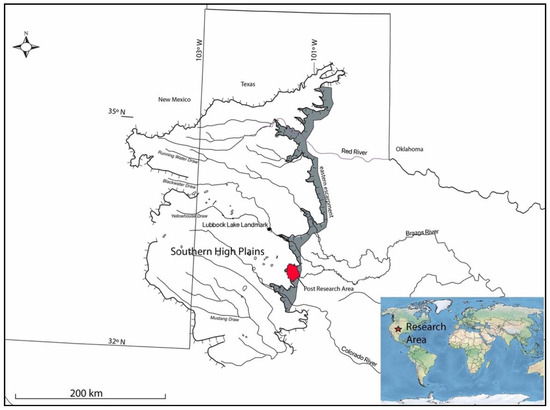
Figure 1.
Southern High Plains with its regional drainage system, eastern escarpment ecotone in gray, and locations of the greater Post research area and Lubbock Lake landmark as noted in the text.
Spring Creek is part of the South Fork of the Double Mountain Fork of the Brazos River drainage and lies within the larger Post research area inside an extensive historic ranch (Figure 2). An initial overview of the sediments and soils [8] across that larger research area (a mesoscale landscape study) has pointed out: (1) Late Pleistocene and Early Holocene sediments and soils occur in the upper tributary drainages; and (2) these areas are targets for future research, particularly for locating in-situ archaeological sites.
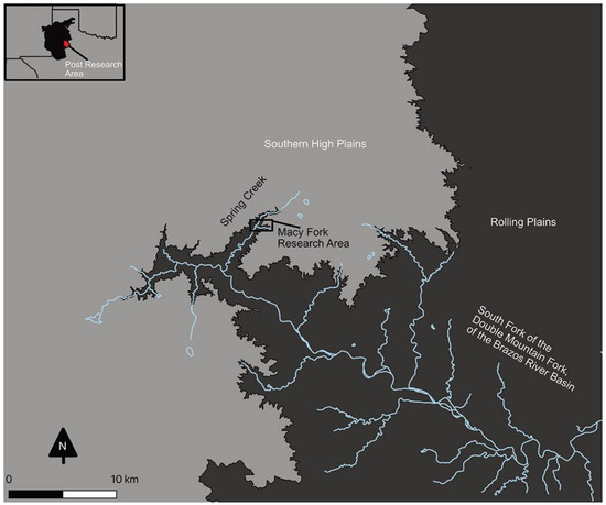
Figure 2.
Spring Creek research area in the Southern High Plains eastern escarpment ecotone.
The research reported here expands the initial work in upper Spring Creek (e.g., [1,8]) based on additional profiles, stratigraphic refinement, and an increased number of radiocarbon dates. Of the 19 localities in Conley [1] and Conley et al. [2], only one (Macy Locality 10) is within the Spring Creek Valley. The previous study of that one profile has identified a buried soil and provided a radiocarbon date from the A-horizon of the buried soil. Of the 17 localities in Murphy et al. [8], only one (Macy Locality 100) is within the Spring Creek Valley. Of the one profile previously studied for Macy Locality 100, the broad depositional units then defined have been refined (e.g., current units 2 and 5 not previously identified) and the depositional mode revised. Of the four radiocarbon dates then available for Macy Locality 100, additional dates indicate that one now is out-of-sequence and has been discounted. Within the current total of six localities, an additional 14 profiles and a core have been recorded along with an expanded radiocarbon dating effort. These latest data have led to new insights into the stratigraphy and geomorphic processes that have preserved older sediments and soils within upper Spring Creek.
Across the North American grasslands, a number of large-scale (e.g., [10,11,12,13,14,15,16,17,18,19,20,21,22,23,24,25]) and small-scale (e.g., [26,27,28,29,30]) Late Quaternary landscape studies have been undertaken. These studies indicate a variety of natural processes affecting landscape development and preservation of sedimentological, biotic, and cultural records through time. Results from these studies underscore that a one-model-fits-all approach is not appropriate. Instead, regional differences occur influenced by such factors as local processes, geomorphology, and climate.
The Spring Creek research fits within this context of regional variation. The stratigraphic framework and geochronology from the small-scale study at Lubbock Lake [31,32] within Yellowhouse Draw (Figure 1) on the eastern Southern High Plains (part of the North Fork of the Double Mountain Fork of the Brazos River drainage) have identified five stratigraphic units within the Late Quaternary valley fill. That framework and geochronology is a building block that became the initial model for the regional drainage system. Holliday’s [22] large-scale landscape study examining the regional stratigraphy and geochronology of the valley fills of the Southern High Plains drainage system has confirmed and refined that model. Further, over the past decades, research has focused on the extensive Late Quaternary records of the regional draw system (e.g., [31,32]) while exploring the playas, salinas, and dunes of the high plains surface (e.g., [33,34,35,36,37]). The Spring Creek study examines the Late Quaternary record within a different setting—that of the erosional eastern escarpment breaks.
This study, then, examines the geographic distribution of the sedimentary and stratigraphic records developed in the escarpment breaks within the ecotonal area between the Southern High Plains and the westernmost Rolling Plains. The aims of this study are to: (1) provide a preliminary framework for the understanding of the drainage-wide sediments and stratigraphy; (2) present an initial assessment of the available radiocarbon dates toward a firmer foundation for geochronologic development; and (3) explore a comparison with the Southern High Plains regional record. The current research focuses on a 774 m transect of the Spring Creek drainage, from Macy Fork to 222 m below the confluence of Macy Fork with Spring Creek proper (Figure 3).
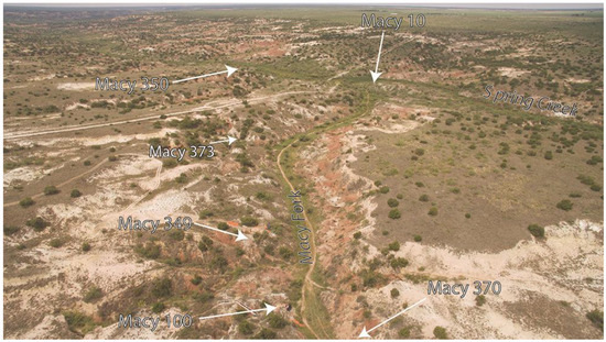
Figure 3.
Unmanned aerial vehicle image of Spring Creek drainage with the location of localities along the transect; view to the west.
Research
The research is couched in a framework of landscape evolution, landforms, and stability within geomorphology (e.g., [38]) and soil geomorphology (e.g., [39,40]) principles and concepts. Both form (morphology) and geomorphic processes, as well as the interrelationship between them, are important in understanding landscape evolution [38]. This landscape approach, in part outlined by Johnson [41], views the geomorphic process as a dynamic factor influencing the formation and preservation of various records (e.g., stratigraphic, environmental, archaeological) of the past. Both depositional and erosional pathways are involved in the geomorphic process that influences landscape development. Erosion is a major dynamic factor having pronounced regional influence on the broader research area. For the purposes here, that influence is exerted beginning with the formation of the escarpment starting sometime in the Pliocene after the final deposition of the Ogallala Formation [42].
Physically, the landscape is composed of landforms and landscape elements that are dependent on scales [43]. Landforms are geomorphic features that occur on the ground surface that can be at various scales from local to regional [44]. Geologic structure and geomorphic process govern their formation and development. Landscape elements are located on landforms and generally localized with particular topographic and geomorphic characteristics [43]. Landscape elements both provide the potential for material deposition (whether archaeological or paleontological) and influence the location for such deposition. Landscape elements (e.g., a fluvial terrace as in the study area) appear more affected by the geomorphic process. Further, landforms and their associated landscape elements are affected by time.
Conceptually, the climate is a major external variable that influences geomorphic processes within fluvial landscapes [45,46]. Landscapes are open systems where drainage basins are subjected to aggradation and degradation of valley floors influenced by changes in climate. Changes in sediment availability and transport influence whether aggradation or degradation occurs in a drainage basin. Equilibrium and disequilibrium modes occur through time and involve the concept of the threshold of critical stream power [45] (p. 16). Stream power applies to both perennial and ephemeral streams, as well as the transition from one type of stream to another within a drainage basin. Major floods play a role in disequilibrium modes and crossing thresholds within a drainage basin [45,47,48]. Stream flow in the Spring Creek drainage, today and in the past, primarily is from spring discharge. Of the 54 active springs and seeps in upper Spring Creek, eight are along the Macy Fork of the transect (Figure 4). Intense rains produce run-off events that can cause flooding and cut and fill occurrences.
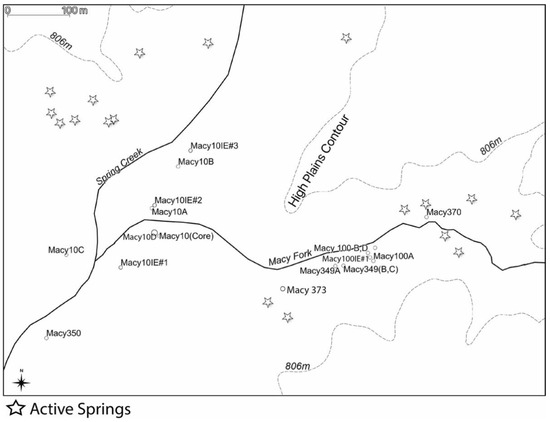
Figure 4.
Spring Creek drainage with location of profiles, core, isolated exposures (designated as IE), and active springs along the transect.
2. Materials and Methods
The landowners granted access, permission to conduct the long-term research program and have donated all objects, specimens, and samples collected each year to the Museum of Texas Tech University (Lubbock, TX, USA) through a signed deed-of-gift. The specific research occurred over a span of 11 years (2008–2018) and involved samples, specimens, and field documentation from Museum accessions TTU2008.040, TTU2009.029, TTU2010.045, TTU2011.019, TTU2012.046, TTU2013.027, TTU2013.051, TTU2014.027, TTU2014.047, TTU2015.015, TTU2015.037, TTU2015.051, TTU2015.054, TTU2016.048, TTU2016.049, TTU2017.019, TTU2017.020, TTU2017.021, TTU2018.020, TTU2018.021, and TTU2018.074.
An alphanumeric bookkeeping system was employed to record the locations of garnered information, samples, and objects (e.g., archaeological site, paleontological locale, isolated profile, or series of profiles in one locale). Designations were assigned as locations were encountered. The vertical and horizontal spatial locations for all locality and profile datums were recorded using a Trimble R8 GPS base station. A series of 14 profiles, a core location, and four isolated exposure locations were located along both sides of Macy Fork and upper Spring Creek proper (Figure 3 and Figure 4). Profile locations were natural cut-bank exposures (n = 11) or excavation exposures (n = 3). One deep core (7.5 cm in diameter; 8.4 m deep) was taken using a Giddings hydraulic soil probe and sampled for radiocarbon dating. The core was positioned to examine the stratigraphy on the south side of Macy Fork just upstream of its confluence with Spring Creek in a location that accommodated the Giddings rig. Isolated exposures provided a cleaned, fresh face of unit 3 only as it was traced laterally.
Profile depth varied from 1.8 to 8.4 m, with some profiles exposing only a portion of the stratigraphic sequence. Stratigraphic exposures were described using standard stratigraphic principles, methods, and nomenclature (e.g., [49,50,51,52,53]). Profile descriptions combined geologic stratigraphy and soil profiles, with both geology and pedology nomenclature used in the profile descriptions. An informal alphanumeric designation was used for the lithostratigraphic units identified so as not to imply correlation with the regional stratigraphy [22] and cause confusion. The informal designation was a combination of the term unit (lower case) and numerical sequence, e.g., unit 1 [54] (pp. 1560, 1570). Units were numbered from oldest to youngest, with 1 being the lowest unit.
Soils and sediment were described in the field (including texture and color) and sampled using standard soil methods and nomenclature [55,56,57,58]. Special emphasis was placed on buried A-horizons. Field observations (descriptions and characteristics) were the most informative, as noted in other regional stratigraphic studies (e.g., [22,36]). Stratigraphic correlation within the upper Spring Creek drainage was based on lithological and pedological characteristics (i.e., buried A-horizons) of the sediments exposed in the transect examined.
Radiocarbon dating involved organic sediments (Table A1 in Appendix A), charcoal (Table A2), and bone (Table A3), totaling 85 samples. From those dated samples, only 5 (5.9%) have been cited previously (four in Murphy et al. [8], Macy Locality 100 profile A, Table A1; and one in Conley et al. [2], Macy Locality 10 profile B, Table A1). The current radiocarbon results, then, provide a 94.1% increase in dated samples for the transect area. Charcoal and bone samples came from excavation units. Organic sediment samples were recovered from excavation units, cut-bank exposures, the core, and the isolated exposures. The sampling methodology for organic sediment samples followed that of Haas et al. [59]. Profiles and isolated exposures were cleaned back at least 50 cm to create a fresh exposure from which samples were taken.
Organic sediment samples have been dated by the University of Arizona (A and AA acronyms) and Illinois State Geological Survey (ISGS acronym) (Table A1) using different methodologies. For all organic sediment samples, regardless of the lab, two fractions (humate and residue fractions or pyrolysis volatile (Py-V) and pyrolysis residue (Py-R) fractions) have been dated to test for possible contamination by younger carbon. This approach produces a pair of dates per sample. Each date in the couplet is evaluated, and the older of the two dates is considered closer to a reliable age (contamination by younger carbon being more likely than from older carbon; [22,60,61]. Studies demonstrate that no fraction is consistently the oldest (e.g., [60,62,63]) and that finding was the case for the Spring Creek organic sediment couplet dates. This discrepancy is related to pre-burial (e.g., humification and translocation processes) and post-burial (e.g., continued microbial activity and dissolved transport of young carbon contaminants being moved down the profile) factors [60,62]. Evaluating both fractions appears among the best methods to address any susceptibility to contamination that could lead to aberrant young dates. The results in the tables are expressed in uncalibrated but isotopic fractionation-corrected radiocarbon ages and calibrated to calendar years. Calibration of the radiocarbon ages to calendar years has been performed with OxCal v4.4 [64] using the IntCal 20 atmospheric curve (1 standard deviation) [65]. All ages cited in the text are given as radiocarbon years before present (14C yr B.P.) with calendar years in parentheses.
Advances in bone dating [66,67,68] indicate that reliable ages in general now are possible. The focus is on collagen (i.e., protein remnants; [67,69]) dating using ultrafiltration [69,70,71] and XAD resin chromatographic [72] methods for removal of contaminants and determining the level of intact collagen as measured by carbon/nitrogen (C:N) ratios [68] (p. 81). The ultrafiltration method (that separates high molecular weight components from low molecular weight fractions; [69,70]) has been used for bone dates reported here. A C:N ratio range of 2.9 to 3.5 has been used as an indicator of collagen preservation and the likelihood of producing sufficient collagen for dating [73,74,75,76,77], with values greater than 3.5 having an increased likelihood of contamination [68] (p. 81).
For transparency, all radiocarbon dates received are reported (Table A1, Table A2 and Table A3). Radiocarbon dating is continuing in the Spring Creek drainage basin, and the geochronology reported here is a first approximation for the stratigraphic sequence. As more dates are received, a more fine-grained assessment of the effects of the depositional settings (alluvial, colluvial, aeolian) is in order.
Assessment of the radiocarbon dates (Table 1) followed the stratigraphic principle of superposition and involved examining chronological order within a profile and stratigraphic unit. The ± error of any out-of-sequence ages was examined at 1 sigma in terms of potential overlap with its nearest in-sequence age. For organic sediment dates, the oldest date of the couplet first was determined, and then that age was placed in the sequence to assess chronological order. When only one of the two fractions was dated successfully, these samples were not included in the analysis because the oldest of the couplet could not be ascertained. It was expected that at least 50% of the radiocarbon dates received on the organic sediments would be discounted. Radiocarbon dates were evaluated by unit in each profile to create a chronological sequence of dates for that profile by unit. Selection criteria or process to establish a profile chronology were the use of the oldest of the couplet received for organic sediments and using the ± error at 1 sigma to eliminate any out-of-sequence ages within a unit. The chronological sequences of each profile and their exposed units were the basis for establishing the geochronology of the Spring Creek transect.

Table 1.
Accepted radiocarbon ages from the Spring Creek research transect.
3. Results
3.1. Stratigraphy
The local bedrock for the Spring Creek transect and drainage is the Triassic Dockum Group [78], upon which the Late Quaternary stratigraphic sequence rests. Locally, the Dockum Group consists of sandstone, siltstone, conglomerate, and metamorphic rocks [78]. The upper Spring Creek drainage has cut through the Miocene-Pliocene Ogallala Formation [42] to the local bedrock. Nearby are the Spring Creek beds [33] (p. 495), [79], a Pleistocene lake basin inset into the Ogallala Formation and exposed by escarpment erosion (Figure 5).
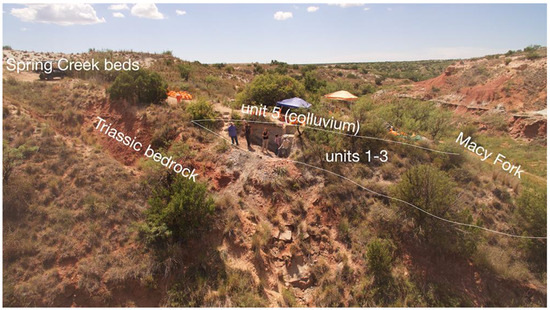
Figure 5.
View along Macy Fork showing source locations for rocks and sediments found within the Late Quaternary Spring Creek drainage; view to the southwest.
Six Late Quaternary depositional units are identified within the transect that encompassed six localities (Figure 3). Macy Locality 10, Macy Locality 100, and Macy Locality 349 have multiple profiles, while Macy Locality 350, Macy Locality 370, and Macy Locality 373 have one profile each (Figure 3 and Figure 4). No one profile exposes all six units, either because of erosion or lack of deposition. Landscape position within the drainage and upstream vs. downstream play a role in that differential record. In the following, the description of each unit and the interpretation are combined together.
Unit 1 is the lowermost unit and consists of basal gravels that rest directly on the Triassic bedrock. This fluvial unit contains gravel zones with discontinuous layers of sands and muds. Larger gravels occur in dense pockets or layers, while some may occur more isolated in the sand. Clasts 5 cm in diameter (very coarse pebbles; [80]) are common but can occur up to 30 cm in diameter (very small boulder; [80]). The basal yellow to red gravels are a mix of reworked Ogallala Formation materials and Triassic sandstone. These sands and gravels reflect the valley axis at the time and free-flowing waters capable of moving clasts up to 30 cm in size. This unit is up to 160+ cm thick in profiles where it is exposed.
Unit 2 rests conformably on the basal gravels. This lower fluvio-lacustrine unit primarily consists of light to dark gray silty and sandy muds. The lower section contains cross-bedded features and a few lenses of medium sand and scattered fine (pea) gravel (1–9 mm in diameter [79]) within the silty sediments. The upper section has more sand and is a sandier mud. These sediments reflect slow-moving, ponded waters within a poorly drained area. This unit ranges from 70 cm to more than 3 m thick in its exposures.
Unit 3 rests conformably on unit 2 (lower fluvio-lacustrine unit) or unit 1 (basal gravels). This middle fluvio-lacustrine unit consists of stratified layers (1–30 cm thick) of silty clay muds alternating with silty clay. Within the sequence, 1 cm thick layers of carbonized plant remains and 1 cm thick fine to medium size (9–16 mm) gravels can occur. The downstream profiles (Figure 3 and Figure 4) have 1–5 cm thick layers of diatomaceous sediment within the sequence. The thickness of the individual mud beds varies but, in general, decreases upwards. These sediments also reflect a poorly drained area high in organic content. This unit ranges from 60 to 270 cm in thickness.
Unit 4 rests conformably on unit 3 (middle fluvio-lacustrine unit). This upper fluvio-lacustrine unit is composed primarily of silty clay to silty loam sediments, with interspersed pedogenic soft secondary carbonate masses and root tracings [1,2]. A buried soil delineates the upper boundary and represents a period of landscape stability. Further, clay films occur in the 2Btk1b1 and 2Btk2b2 horizons that indicate a period of landscape stability and increased effective soil moisture sufficient to translocate the clay. The soil is organic-rich, with 1.0 to 1.5% organic carbon [1]. This high amount is reflective of soil formation in a situation of sufficient water to sustain plant growth. Redoximorphic features are absent. While standing water was not present, available moisture is conducive to vegetative growth [1] (pp. 100–101). In some profiles, the removal or erosion of the A-horizon creates a disconformity at the top of the unit that is denoted by an irregular surface. These sediments reflect the continuation of poorly drained conditions within decreasing surface water availability. This unit is up to 140 cm thick in profiles where it occurs.
Unit 5 rests unconformably on one of the fluvio-lacustrine units (unit 2, unit 3, or unit 4). This colluvial unit consists of unconsolidated sediments of weakly bedded light gray silt and clay with reworked clasts predominately of the Spring Creek beds and some secondary Ogallala Formation and Dockum Group materials (Figure 5). Laid down episodically, these sediments are redeposited materials developed through sheet erosion of the surrounding hillslopes and uplands from unconsolidated overland flows of water, most likely due to heavy rains. Unit 5 colluvium typically is the upper stratigraphic unit along the erosional edges within the Spring Creek transect where steep slope gradients occur. The modern soil has developed in upper unit 5 when unit 6 is not present. This unit is up to 1.5 m thick along the transect.
Unit 6 consists of aeolian deposits that rest conformably on one of the fluvio-lacustrine units (units 2, 3, or 4) or caps the colluvial unit 5. This unit consists of sandy loam to silty loam with some fine gravel lenses (due to slope wash) and one or more weakly developed buried A-horizons. These sediments indicate erosion and deposition caused primarily by wind action. The aeolian unit is encountered on upland surfaces with less slope gradient and generally blankets the study area. The modern soil has developed in upper unit 6 when present. This unit is up to 3 m thick where exposed.
The sands and gravels of unit 1 represent a free-flowing stream within a bedrock channel cut by vertical erosion. The unit is exposed on both sides of the transect, and the channel is confined within steep gradients. A change occurs in the fluvial regime with the deposition of the succeeding three fluvio-lacustrine units (units 2, 3, and 4). The muds of unit 2 reflect a decrease in overall average water flow velocity. These lacustrine and paludal deposits indicate ponds and shallow marshes within the waterway. While both may have occurred throughout the sequence, unit 3, with its sequence of diatomaceous layers, appears more pond-related. What caused the flowing water to pond has not been determined.
Macy Locality 370 is the furthest upstream locality (Figure 3 and Figure 4). It is within the valley axis, and the profile exposed a very thick unit 2 (lower fluvio-lacustrine unit) overlain by colluvium (unit 5). Macy Locality 100 profile C (Figure 3 and Figure 4), on the opposite creek bank and 95 m downstream, is within the same landscape setting yet has all three fluvio-lacustrine deposits (units 2, 3, and 4). Given the massive thickness (3 m) of unit 2 at Macy Locality 370, it does not seem likely that the other two fluvio-lacustrine units were deposited and then eroded away prior to colluvial deposition. The difference may be the immediate presence of springs (two still active today) at Macy Locality 370 that influenced the continued development of unit 2.
The ponding events within unit 3 (middle fluvio-lacustrine unit) vary from upstream to downstream along the transect. Upstream, ponds seem shallow and interspersed with muds of varying thickness that represent times when water was just below the surface. These ponds and muds expand laterally upslope from the valley axis (Macy Locality 100 profile A, Macy Locality 349 profile B; Figure 3 and Figure 4). Downstream, deep ponds exist at the confluence of Macy Fork and Spring Creek proper, expanding downstream for a distance of at least 222 m (Macy Locality 350; Figure 3 and Figure 4). The downstream ponds reach a lateral extent of ~85 m with water depths of ~5–15 m. These ponding events represented by layers of diatomaceous sediments are interspersed with multiple muds of varying thicknesses.
Unit 4 (upper fluvio-lacustrine unit) appears to reflect a return to more marshy conditions than the open ponded waters. It is a more homogeneous unit than the other two and interpreted as representing an aggrading marsh in which a wetland soil developed. An erosional surface occurs at the top of the unit, and it is overlain disconformably by colluvium (unit 5).
3.2. Radiocarbon Dating
Of the six localities investigated along the transect, four have accepted (i.e., considered reliable) radiocarbon dates. While all profiles were sampled for radiocarbon dating, the dates for profiles Macy 370 (Figure 6) (Table A4 in Appendix B), Macy 373 (Figure 6) (Table A1 and Table A5), Macy 100 profile D (Table A1 and Table A6), and Macy 10 profile D (Figure 6) (Table A1 and Table A7), as well as the Macy 100 isolated exposure 1, have not been accepted due to out-of-sequence concerns or return of only one couplet date (Table A1). Macy Locality 100 and Macy Locality 349 (Figure 3) have the greater diversity of sample types (organic sediments, charcoal, and bone). Organic sediment samples dominate the assemblage of dated samples. Of the 85 samples dated, 72 (84.7%) are organic sediment samples. Ages from these organic sediment samples heavily influence the chronologic sequence being developed along the Spring Creek transect.
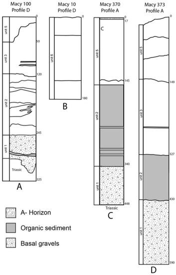
Figure 6.
Macy locality profiles along the transect lacking accepted radiocarbon dates; uppercase letters at the bottom of each profile designate the individual profiles as cited in the text.
Of the 143 radiocarbon dates obtained from the 85 samples, the initial winnowing process has yielded 40 accepted dates (Table 1). Of these, 33 (82.5%) are from organic sediments. With half the couplet dates from the organic sediment samples being discounted, the overall return rate is 47.1%. Several factors appear in play in this return rate depending on sample type. One factor is older charcoal and bone washing into the stream or ponded deposits from run-off events during the deposition of a unit. Another is the possible need to cut back weathered bank exposures more than the standard 50 cm [59,63] to provide a fresh, uncontaminated exposure for sampling. A third factor is the lack of sufficient organics in some samples due to such factors as leaching or weak soil development. The most likely major factor, however, is the heavy calcium carbonate burden in the organic sediment samples beyond that which can be removed reasonably in the pretreatment process. This burden is a common regional problem, e.g., [22].
3.2.1. Macy Locality 100 Profile B
At Macy Locality 100 (Figure 3 and Figure 4), three of the four profiles (Figure 7) (Table A6) have radiocarbon dates. The accepted dates from the three profiles (Table 1) provide some age indication for the basal gravels and the succeeding three fluvio-lacustrine units. A bone age of ~11,550 14C yr B.P. (13,469–13,390 calendar years) dates the basal gravels unit exposed in the Macy Locality 100 profile B (Figure 7B) (Table A6). Interbedded muds or organic lenses that occur within the unit above the location of the bone date have yielded five out-of-sequence dates that have been discounted (Table A1). Nonetheless, these ages generally support the Late Pleistocene age of the unit. A charcoal age of ~11,300 14C yr (13,291–13,119 calendar years) at the bottom of unit 2 (lower fluvio-lacustrine unit; Figure 7B) dates the contact between the two units and provides a burial age for the basal gravels.
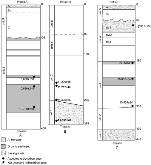
Figure 7.
Macy Locality 100 profiles; note that the date in brackets near the top of profile C, although not accepted, is depicted for reasons outlined in the text; uppercase letters at the bottom of each profile designate the individual profiles as cited in the text.
In unit 2, two charcoal dates within 1 cm elevation of each other overlap in their error range (Figure 7B) and suggest an age of ~11,250 14C yr B.P. (13,237–13,125 calendar years). The charcoal and bone dates (Table A2 and Table A3) in the upper part of the unit have been discounted as out-of-sequence. The dates themselves may not be erroneous but rather more likely represent secondary redeposition of materials washing into unit 2 during sedimentation. The same view, i.e., redeposition, could be taken for the three accepted charcoal dates. While they may well represent washed-in material, the dates have been retained because they are in chronological order within the unit.
3.2.2. Macy Locality 100 Profile C
The accepted dates from Macy Locality 100 profile C (Figure 7C) (Table 1 and Table A8) provide an age range for unit 3 (middle fluvio-lacustrine unit). A date of ~10,930 14C yr B.P. (12,880–12,769 calendar years), from the bottom of unit 3 in profile C, indicates the contact between units 2 and 3 is ~11,000 14C yr B.P. (~13,000 calendar years). Similarly, the date on the organic mud at the top of the unit denotes an age of ~8500 14C yr B.P. (9535–9478 calendar years) for the contact between units 3 and 4 (upper fluvio-lacustrine unit). The buried soil at the top of unit 4 has been impacted by erosion and subsequently buried by colluvium (unit 5). Because both fractions of the organic sediment sample from the buried soil could not be dated, the one returned couplet date is discounted (Figure 7C) (Table A1). Nevertheless, it is informative and fits with an accepted age on this soil in other transect profiles downstream and seems to provide a reasonable estimate.
3.2.3. Macy Locality 100 Profile A
Three accepted ages from this profile (Figure 7A) (Table 1 and Table A9) date the lower muds of unit 3 (middle fluvio-lacustrine unit) between ~10,730 to ~10,630 14C yr B.P. (13,071–12,197 to 12,758–12.196 calendar years). These ages fit well with the age range for lower unit 3 from Macy Locality 100 profile C (Figure 7C). Of the four radiocarbon dates from this profile reported in Murphy et al. [8] (pp. 63, 67), one has been discounted as out-of-sequence (Table 1 and Table A1).
3.2.4. Macy Locality 349 Profile A
Profile A (Figure 8) (Table A10) represents an upslope position in the Macy Fork Valley. It exposes unit 3 (middle fluvio-lacustrine unit) resting on basal gravels (unit 1) and buried by unit 5 colluvium as well as internal cut and fill episodes within units 3 and 5. The four accepted dates are within unit 3 (Table 1). These dates provide an additional age on this unit that is concordant with and strengthen the unit’s age range as outlined by the Macy Locality 100 dates on the unit. The overlapping ages based on bone (Table 1 and Table A3) indicate that an associated bison bone pile within the unit dates ~10,400 14C yr B.P. (~12,616–12,102 calendar years). Bison bone exposed in profile B (Figure 9) correlates with this bone pile.
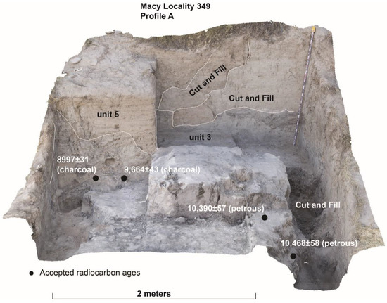
Figure 8.
Macy Locality 349 profile A; note the various cut and fill events in unit 3 and unit 5; the height of the tape measure is at 155 cm.
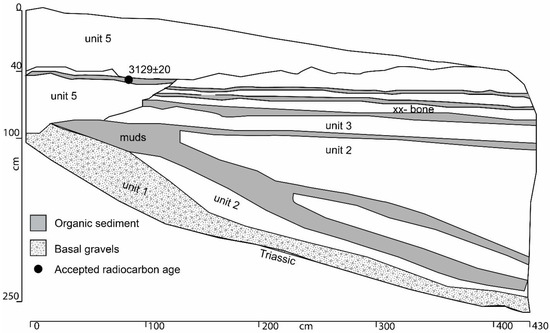
Figure 9.
Macy Locality 349 profile B; note the interbedded muds of unit 2 and unit 3.
Profile A indicates a number of erosional events have impacted the valley slope along this part of the transect as well as the bone pile. One of two cut and fill episodes affecting the bone pile occurs ~800 radiocarbon years after bone pile deposition (Figure 8). That event is dated to ~9600 14C yr B.P. (11,184–10,879 calendar years) with infilling beginning by ~8997 14C yr B.P. (10,225–10,179 calendar years). A marked erosional boundary occurs between unit 3 (middle fluvio-lacustrine unit) and colluvial unit 5, with the erosion of unit 3 down to the bone pile. The colluvial unit itself underwent cut and fill episodes with subsequent colluvial deposition.
3.2.5. Macy Locality 349 Profiles B and C
Profile B (Figure 9) (Table A11) is in a similar upslope position as profile A, while profile C (Figure 10) (Table A12) parallels the valley axis. Accepted ages from these profiles (Table 1) date the unit 5 colluvial deposition. In both profiles, unit 5 rests unconformably on unit 3. Deposition of colluvium began earlier in the upslope position at ~3130 14C yr B.P. (3380–3275 calendar years). Erosion appears to have continued in the valley axis, with stabilization (i.e., cessation of erosion) and deposition of colluvium not until ~1430 14C yr B.P. (1353–1299 calendar years).
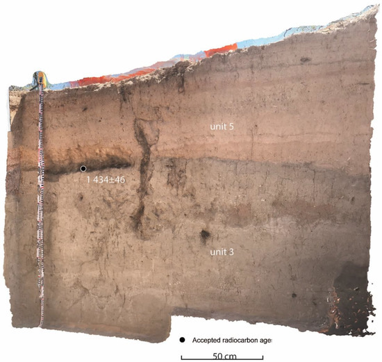
Figure 10.
Macy Locality 349 profile C; note the bedded nature of unit 5; the height of the tape measure is 136 cm.
3.2.6. Macy Locality 10 Profiles A and C
Accepted radiocarbon dates (Table 1) associated with unit 3 (middle fluvio-lacustrine unit) in Macy Locality 10 profiles A (Figure 11A) (Table A13) and C (Figure 11C) (Table A14) date sequential muds and reinforce the age range outlined in the Macy Locality 100 dates on the unit and complement those from this unit in other profiles. The series of five ages from profile A (Figure 11A) date the lower and middle sections of the depositional unit. The erosional disconformity at the top of unit 3 is a reoccurring manifestation in the Spring Creek transect. At Macy Locality 10, this erosional event dates after ~9170 14C yr B.P. (10,407–10,243 calendar years) (Figure 11C), and the unit is overlain by a thin veneer of unit 5 colluvium in the profile C location (Figure 11C). The sequence of radiocarbon ages within both profiles indicates that upper unit 3 has been removed and the soil truncated.
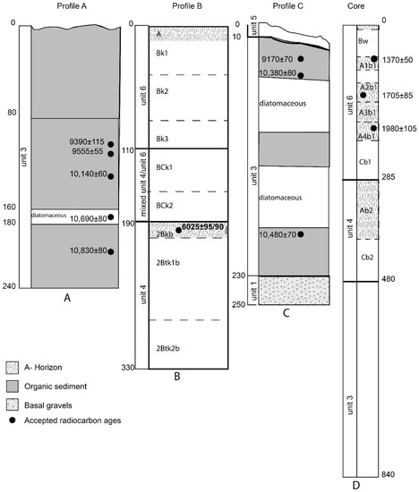
Figure 11.
Macy Locality 10 profiles; uppercase letters at the bottom of each profile designate the individual profiles as cited in the text.
3.2.7. Macy Locality 10 Profile B
This profile (Figure 11B) (Table A15) has a well-developed soil within unit 4 (upper fluvio-lacustrine unit) that was buried around ~6000 14C yr B.P. (6988–6744 calendar years) (Table 1). Burial is through an influx of aeolian sediments into the unit and, ultimately, a changeover to only aeolian sediments (unit 6). This situation is different from that seen in Macy Locality 100 profile C (Figure 7C), where erosion of the buried soil in unit 4 dating about the same time has occurred. Unit 4 is buried by colluvial unit 5.
3.2.8. Macy Locality 10 Core and Isolated Exposure Locations
Radiocarbon dates for the Macy 10 core (Figure 11D) (Table 1 and Table A16) were limited to the aeolian unit 6 and date the three uppermost buried A-horizons. For the lowermost dated buried A-horizon (A3; Figure 11D) (Table 1), the date indicated that burial occurred around ~1980 14C yr B.P. (2043–1747 calendar years). The middle of the three dated buried A-horizons (A2; Figure 11D) (Table 1) was buried around ~1705 14C yr B.P. (1709–1521 calendar years), indicating an approximate 230 radiocarbon years for aeolian deposition, a stable surface with soil development, and then another round of aeolian deposition. The uppermost-dated buried A-horizon (A1; Figure 11D) (Table 1) developed over a more than 350 radiocarbon year period, with burial around ~1370 14C yr B.P. (1344–1180 calendar years). The multiple buried A-horizons coupled with the radiocarbon dates indicated aeolian deposition was episodic with stable landscapes of several hundred years duration during at least the past ~2000 radiocarbon years of the Late Holocene.
The three isolated exposure locations target the multiple organic muds in unit 3 (middle fluvio-lacustrine unit) in relation to Macy 10 profile A (Figure 11A). Dates from isolated exposure location 3 (Figure 4) (Table 1) come from the top and bottom of the same mud. The upper date (9530 14C yr B.P.; 11,071–10,700 calendar years) (Table 1) on this mud overlaps with one of the dates (9555 14C yr B.P.; 11,072–10,749 calendar years) (Table 1) from Macy 10 profile A (Figure 11A) and provides a link between these two locations. The combined dates from the three locations (Table 1) appear to date three sequential muds from ~9790 14C yr B.P. to ~9270 14C yr B.P. (11,595–10,798 to 10,565–10,302 calendar years). Correlation with Macy 10 profile A (Figure 11A) indicates that these unit 3 ages appear to come from the middle section of the depositional unit. Downstream at just below the confluence of Macy Fork and Spring Creek proper, this age range fits within the dated uppermost thick mud at the top of unit 3 in Macy Locality 10 profile C (Figure 11C).
3.2.9. Macy Locality 350
Downstream at Macy Locality 350 (Figure 12) (Table A17) along Spring Creek proper, the three accepted dates (Table 1) underscore the age of upper unit 2 (lower fluvio-lacustrine unit) and confirm the contact of unit 2 and unit 3 (middle fluvio-lacustrine unit) at ~11,000 14C yr B.P. (13,092–12,900 calendar years). Deposition of the massive laminated diatomaceous deposits within unit 3 begins around ~11,000 14C yr B.P. (13,092–12,900 calendar years), and various laminae are dated between ~10,800 14C yr B.P. (12,760–12,736 calendar years) and ~9320 14C yr B.P. (10,575–10,499 calendar years). Associated with the major ponding events reflected in the Macy 10 profiles, this age range spans the sequential muds formed in unit 3 upstream from this locality.
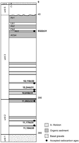
Figure 12.
Macy Locality 350 profile; note that aeolian sediments (unit 6) cap the colluvial deposits (unit 5).
3.3. Spring Creek Geochronology
Summarizing the geochronology of the Spring Creek drainage as seen along this transect, unit 1 (the basal gravels exposed in 10 profiles and the Macy Locality 10 core) dates from ~11,550 14C yr B.P. to ~11,300 14C yr B.P. (13,469–13,390 to 13,291–13,119 calendar years). As this unit extends deeper than the exposed profiles, the unit most likely dates even earlier. Unit 1 is found throughout the transect, as are all three of the succeeding fluvio-lacustrine units (units 2, 3, and 4). Unit 2 is exposed in eight profiles. The age of the unit is indicated by concordant dates from Macy Locality 100 profiles B and C (Figure 7B,C) and Macy Locality 350 (Figure 12). The date of ~11,300 14C yr B.P. (13,291–13,119 calendar years) at the bottom of the unit (Macy Locality 100 profile B; Figure 7B) and contact with unit 3 at ~11,000 14C yr B.P. (12,880–12,769 calendar years) (Macy Locality 100 profile C, Figure 11C) (Macy Locality 350, Figure 12) indicate a short time span of ~300 radiocarbon years for this unit. The dates from the two localities are concordant and underscore the beginning of unit 3 (middle fluvio-lacustrine unit) deposition at ~11,000 14C yr B.P (12,880–12,769 calendar years). Deposition of unit 2 (lower fluvio-lacustrine unit) then is from ~11,300 14C yr B.P. to ~11,000 14C yr B.P. (13,291–13,119 to calendar years to 12,880–12,769 calendar years).
Unit 3 (middle fluvio-lacustrine unit) is exposed in 11 profiles, the three Macy 10 isolated exposure locations, and the Macy 10 core. It currently is the best-dated unit in the transect, with 19 accepted dates. Its age range indicates deposition from ~11,000 14C yr B.P. (12,880–12,769 calendar years) (Macy Locality 100 profile C (Figure 7C); Macy Locality 350 Figure 12) to ~8500 14C yr B.P. (9535–9478 calendar years) (Macy Locality 100 profile C; Figure 7C). Numerous dated sequential muds occur during this depositional period. Unit 3 is impacted by cut and fill events during deposition and post-deposition. The cut and fill events are lateral erosion caused by floods in the valley within the aggrading stream. These erosional channels subsequently fill after a flood subsided. One such event is dated to ~9600 14C yr B.P. (11,184–10,879 calendar years) (Macy Locality 349 profile A; Figure 8).
An erosional disconformity occurs at the top of unit 3 in several profiles, such as at Macy Locality 10 profile C (Figure 11C) located just below the confluence of Macy Fork and Spring Creek proper. This erosional event postdates ~9170 14C yr B.P. (10,407–10,243 calendar years). If unit 4 (upper fluvio-lacustrine unit) was deposited at this profile location, it has been removed along with the uppermost portion of unit 3. As Macy Locality 350 (Figure 12) records unit 4 deposition, that occurrence suggests unit 4 most likely was removed in the confluence area sometime after ~8500 14C yr B.P. (9535–9478 calendar years).
Unit 4 (upper fluvio-lacustrine unit) is found throughout the transect exposed in three profiles and the Macy Locality 10 core. The age of the unit is indicated by the ~8500 14C yr B.P. date (9535–9478 calendar years) at the top of unit 3 (Macy Locality 100 profile C; Figure 7C) and the ~6000 14C yr B.P. date (6988–6744 calendar years) at the top of unit 4 (Macy Locality 10 profile B; Figure 11B). Deposition ceases ~6000 14C yr B.P. (6988–6744 calendar years), and a soil developed. While the burial of this unit and its A-horizon was gradual in the Macy Locality 10 profile B (Figure 11B), an erosional surface occurs at the top of this unit in the Macy Locality 100 profile C (Figure 7C). The discounted date of ~5900 14C yr B.P. (6781–6675 calendar years) in this profile hints at erosion sometime after 6000 14C yr B.P. (6988–6744 calendar years).
Unit 5 (colluvium) and unit 6 (aeolian), then, post-date 6000 14C yr B.P. 6988–6744 calendar years). Unit 5 is exposed in 12 profiles. Radiocarbon dates for this unit (Macy Locality 349 profiles B and C; Figure 9 and Figure 10) indicate episodic deposition in the Late Holocene beginning as early as ~3100 14C yr B.P. (3380–3275 calendar years). The aeolian unit 6 is exposed in two profiles and the Macy Locality 10 core. Radiocarbon dates for this unit come from weakly developed A-horizons (Macy Locality 10 core; Figure 11D) that indicate episodic deposition in the Late Holocene over at least a ~600 radiocarbon year period, between ~1980 14C yr B.P. to 1370 14C yr B.P. (2043–1747 to 1344–1180 calendar years).
4. Discussion
4.1. The Spring Creek Sequence
The stratigraphic sequence at Spring Creek indicates flowing water during the latest Pleistocene (unit 1 (basal gravels)), and then a change to spring-fed marshes and ponds (units 2, 3, and 4 (fluvio-lacustrine units)) with continuous sedimentation up to ~6000 14C yr B.P. (6988–6744 calendar years). After ~6000 14C yr B.P. (6988–6744 calendar years), downcutting of the Spring Creek drainage removed the ponded sediments along the valley axis through erosion, with only discontinuous remnants remaining. The erosional surface above the ~6000 14C yr B.P. soil (6988–6744 calendar years) then is overlaid by Late Holocene colluvium (along steep slopes; unit 5) and aeolian sediments (unit 6).
Bedrock sources contributing to unit 1 are poorly sorted (no one source dominates) and include well-rounded Ogallala Formation gravels, angular Triassic Dockum Group sandstone pieces, and sediment from the Spring Creek beds. Unit 1 represents a flowing stream. The presence of large size clasts from the Ogallala Formation indicates periodic high energy stream discharge and slope wash within the Spring Creek drainage that contributed to unit 1. The unit 1 latest Pleistocene stream has a relatively greater flow relative to later time periods. That greater flow may result from increased effective moisture levels and less dependence on spring discharge than during the Holocene.
The distribution of unit 2 (lower fluvio-lacustrine unit) appears significant for understanding patterns within upper Spring Creek. The modern channel axis in Macy Fork is deep and entrenched within the Triassic Dockum Group and Ogallala Formation sediments. At the Macy Fork-Spring Creek confluence, today’s Spring Creek channel is broader and shallower than in Macy Fork. Downstream from the Macy Fork-Spring Creek confluence, the current channel is much wider and shallower and appears less entrenched than upstream from the confluence. The Late Pleistocene channel (Macy Fork to upper Spring Creek) also appears to have been entrenched more so than the modern channel. The thick fluvio-lacustrine deposits of units 3 and 4 indicate a broader, shallower Spring Creek.
While the channel fill aspect of the morphology of the drainage transitioned during the Late Pleistocene to Early Holocene, the position of the Dockum Group and Ogallala Formation remained constant throughout. This constant acted as a persistent control on the presence/absence of entrenchment as well as fluvio-lacustrine unit settings. Unit 2 (lower fluvio-lacustrine unit) also may be associated with shifts in channel gradient that could have constrained the drainage flow. The slow-flowing marsh setting of this unit suggested a more clogged, filled channel. A lower gradient at the confluence could have influenced the formation of large ponds at the Macy Fork-Spring Creek confluence. This scenario would be consistent with the increased deposition of clay and silt and reduction in gravel and sand deposition in unit 2.
Further, unit 2 also may be a localized product of greater spring discharge than the other two fluvio-lacustrine units. Springs are active today in the Spring Creek drainage, with some near or adjacent to the Macy Fork unit 2 profiles (Figure 4). While Triassic Dockum Group and Ogallala Formation deposits continue to occur throughout Spring Creek downstream from Macy Fork, they are located relatively distant from the channel axis. In contrast, these deposits are exposed extensively within Macy Fork and form the lateral boundaries of the narrow, entrenched channel.
Unit 3 (middle fluvio-lacustrine unit) and unit 4 (upper fluvio-lacustrine unit) represent Early Holocene shallow and broad ponds and marshes throughout the Macy Fork drainage into Spring Creek proper. Units 2, 3, and 4 are laminated, representing alternating periods of below-water sedimentation and muds (i.e., sedimentation occurring in a water fluctuating marsh/wetland environment). The muds represent mudflats at the edges of contracting ponds and marshes. This alternation most likely reflects times of greater and lesser spring discharge. The discharge fluctuation particularly is noticeable in unit 3, with greater thickness of deposits and increased lamination that culminates in thicker muds. The regional Early Holocene drying and warming trend [81,82] indicates less annual precipitation, increased temperatures and seasonality, and regional droughts. These conditions most likely lead to greater dependence on spring discharge for the water regime in the Spring Creek drainage.
The lengthy age span of unit 3 (~11,000–8500 14C yr B.P.; 12,880–12,769 to 9535–9478 calendar years) is corroborated by dates on this unit downstream from the transect. Macy Locality 3 [8] is ~2.14 km downstream from Macy Locality 350 (southern end of transect) on lower Spring Creek near the confluence with the South Fork. At Macy Locality 3, Unit II of Murphy et al. [8] (pp. 62, 66) is over 5 m thick and composed of current unit 3 (middle fluvio-lacustrine unit) and unit 4 (upper fluvio-lacustrine unit). The radiocarbon sequence at Macy Locality 3 [8] (pp. 62, 66) falls within the span of dates on unit 3 seen in the transect.
Unit 4 (upper fluvio-lacustrine unit) represents the waning stages of ponding. It is a fairly homogenous deposit of silts and clay with fewer and much thinner muds. It is considered to represent an aggrading marsh that terminates in soil development. That soil is buried around ~6000 14C yr B.P. (6988–6744 calendar years). The highly organic, overthickened unit 4 soil along the north side of the valley axis indicates the lateral extent of standing, open waters through the ~2500 radiocarbon years of deposition. Soil development begins earlier along the north side of the valley. Carbonate accumulation, a secondary pedogenic feature from translocated carbonates, increases with depth [1]. This situation indicates that groundwater was just below the surface.
The differential distribution of unit 3 (middle fluvio-lacustrine unit) and unit 4 (upper fluvio-lacustrine unit) through the transect indicates that either they have been eroded away or were not deposited at all localities. Erosion of sediments in the transect occurs after 6000 14C yr B.P. (6988–6744 calendar years). Most profiles indicate an unconformable erosional contact, usually at the top of unit 4 or unit 3. Downstream at Macy Locality 3, unit 4 (Unit II of [8]) deposition/soil development continues until ~5135 14C yr B.P. (6167–5663 calendar years) [8] (pp. 62, 66). The erosional period within the Spring Creek drainage most likely begins post-~5135 14C yr B.P. (6167–5663 calendar years) in the latest middle Holocene. This middle Holocene erosional period appears to be widespread along the southeastern caprock breaks and westernmost Rolling Plains [1,8,29]. During this erosional period, deposition is occurring within the valley of the South Fork [1]. Tributary drainages are being flushed out along the caprock breaks, contributing to deposition further downstream along the river valley. This flushing has impacted the previously deposited units differentially, as exemplified by the Macy Fork-upper Spring Creek transect.
Unit 5 (colluvium) marks the cessation of the erosion period within the Spring Creek drainage and resumption of deposition during the Late Holocene. This unconsolidated material is bedded (Macy Locality 349 profile C; Figure 10), indicating episodic deposition. Deposition begins as early as ~3130 14C yr B.P. (3380–3275 calendar years), and the surface soil is developed in colluvium in some profiles along the transect. The erosional period, then, lasts for around 3000 radiocarbon years. In addition to bedding, the colluvial unit also has undergone cut and fill events caused by overbank flooding and subsequent continuation of deposition (e.g., the terrace setting of Macy Locality 349 profile A; Figure 8). These impacts to the unit indicate that spring discharge and/or intensive rain events were sufficient to cause occasional strong flooding along Macy Fork in the Late Holocene.
Unit 5 is distributed differentially along the transect. It primarily occurs on both sides of the valley in the upper reach of Macy Fork, where slopes are the steepest. It is picked up again at the confluence of Macy Fork and Spring Creek but only along the south side (Macy Locality 10 profile C; Figure 11C) (Macy Locality 350; Figure 12), where the colluvium unit is only ~30 cm thick.
Thick aeolian deposits (unit 6) drape the lower Macy Fork on both sides. This unit starts forming on the north side after 6000 14C yr B.P. (6988–6744 calendar years) (Macy Locality 10 profile B; Figure 11B). Deposition begins to outpace soil formation in unit 4 (upper fluvio-lacustrine unit), and the deposition process transitions into solely wind-blown materials (unit 6). The exact timing of either the outpacing or transition is unknown. Despite the lengthy erosional period (~3000 radiocarbon years), aeolian deposition continues (as preserved in select areas apparently protected from erosion). That situation suggests that the impact of the erosional period was greater along the upper reach of Macy Fork and the south side, just below the confluence. Unit 6 in the Macy Locality 10 core (Figure 11D) contains a series of buried A-horizons developing over at least a 600-radiocarbon year period in the middle of the Late Holocene. Representing buried stable land surfaces, this series indicates that aeolian deposition also was episodic. The radiocarbon ages indicate that these A-horizons formed after the cessation of the lengthy erosional period that ended around ~3130 14C yr B.P. (3380–3275 calendar years).
Although unit 5 and unit 6 are in part contemporaneous, they do not have a lateral stratigraphic facies relationship. At Macy Locality 350 (Figure 12), unit 5 colluvium is overlain conformably by a thin unit 6. The two units are not facies of the same unit but separate stratigraphic units and controlled by different factors beyond landscape position.
4.2. Local Archaeological and Paleontological Implications
The lateral exposure of and differentially preserved Late Quaternary deposits provides opportunities for examining the archaeological and paleontological records of this time, and, in particular, the Late Pleistocene and Early Holocene records. Over 500 pieces of flaked stone have been documented from surface survey at Macy Locality 10 (Figure 3), primarily eroding out of unit 4 (upper fluvio-lacustrine) and unit 6 (aeolian) sediments. Evidence of early Paleoindian Clovis and Folsom activity has been found within the Spring Creek drainage along Macy Fork and at the confluence with Spring Creek. An Alibates Clovis projectile point comes from the current ground surface at Macy Locality 10 (profile C; Figure 3 and Figure 11C). Excavation at Macy Locality 349 (profile A; Figure 3 and Figure 8) has recovered over 50 Edwards Formation resharpening flakes in unit 3 (middle fluvio-lacustrine sediments) from within a bison bone pile dated to ~10,400 14C yr B.P. (12,470–12,191 calendar years). This Folsom-age [77,83] bonebed located along a terrace of Macy Fork has been subjected to at least two cut and fill events as well as erosion to unit 3 with subsequent colluvial deposition. The presence of Paleoindian activity within the Spring Creek drainage suggests that upland camps may be found.
Macy Locality 100 (Figure 3 and Figure 7) in upper Macy Fork is a Late Pleistocene to Early Holocene paleontological locality [6,84] with a faunal record similar to that known for the broader Southern High Plains [82,85,86]. Faunal remains from Macy Locality 100 are consistent with the associated radiocarbon chronology for unit 1 (basal gravels) and unit 2 (lower fluvio-lacustrine sediments). Extinct vertebrates characteristic of the Late Pleistocene occur in these units, with some taxa new to the regional record [6,87,88].
The occurrence of aquatic and wetland taxa at Macy Locality 100 is consistent with interpretations developed from the corresponding sediments. Various taxa are indicative of abundant stream, pond, marsh, and mudflat settings in the Macy Fork during the Late Pleistocene deposition of units 1 and 2 [5]. Macy Locality 100 arvicolines with mesic affinities are extirpated from the region in the Early Holocene by ~8500 14C yr B.P. (9531–9492 calendar years) [85]. These faunal correlations offer a check on the radiocarbon chronology and provide evidence of the validity of the ages retained from the total set of radiocarbon results. Further, the presence of similar deposits with similar radiocarbon ages and both megafauna and microfauna indicates the potential for a significant perspective on the Late Pleistocene biota relative to that from Lubbock Lake [6,86].
4.3. Comparison with the Southern High Plains Regional Record
Unit 1 denotes a flowing stream analogous to the stratum 1 stream of Lubbock Lake [30,31] in Yellowhouse Draw (Figure 1) and the regional draw system [22]. The sand and gravel deposited by the stream at Lubbock Lake represent the initiation of regional Late Quaternary valley fill, following a period of late Wisconsinan incision throughout the regional drainages [22].
The character of the regional transition from flowing stream to ponds and marshes in the Spring Creek record is distinct due to the presence of unit 2 (lower fluvio-lacustrine unit). Unit 2 appears significant in terms of intra-regional comparisons of Late Pleistocene depositional patterns. As a slowly-aggrading freshwater marsh, unit 2 appears to represent a more transitional setting within the Spring Creek drainage between the fluvial sands and gravels of the Late Pleistocene and the large pond setting of the lacustrine and diatomite earliest Holocene unit 3 (middle fluvio-lacustrine unit). The valley fill record of the Southern High Plains (regional Stratum 1 through Stratum 5 as well as local Lubbock Lake stratum 1 through stratum 5; Figure 13) reflects a more marked shift from the strongly flowing streams of regional Stratum 1 (fluvial sand and gravel) to the interconnected ponds of regional Stratum 2 [22,31,32]. The difference observed may be a reflection of the vertical thickness of the latest Pleistocene component within Spring Creek. The Macy Fork profiles of Late Pleistocene unit 1 (basal gravels) and unit 2 (lower fluvio-lacustrine unit) (Figure 2 and Figure 4), equivalent to regional Stratum 1, are significantly thicker than other regional exposures of equivalent age [22]. Therefore, the more expansive record preserved in the Macy Fork profiles may illustrate details of the Southern High Plains Late Pleistocene to Early Holocene fluvial transitions that have not been preserved elsewhere in the region. Alternatively, unit 2 may be an idiosyncratic feature of Spring Creek produced by the landscape and channel morphology of the Macy Fork. Stratigraphic work at other escarpment drainages would need to be performed to determine between the two possibilities.
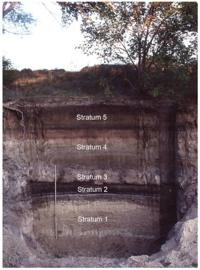
Figure 13.
Southern High Plains regional Late Quaternary stratigraphy (valley fill record) within the drainage system.
The Early Holocene freshwater ponds of unit 3 (middle fluvio-lacustrine unit) and unit 4 (upper fluvio-lacustrine) are similar to and equivalent in age to regional Stratum 2. Burial of the soil that developed in unit 4 occurs around ~6000 14C yr B.P. (6988–6744 calendar years). Pedogenesis in upper Stratum 2 occurs locally throughout the regional drainage system, with local burial ~6300 14C yr B.P. (7257–7170 calendar years) (e.g., Lubbock Lake; [31,32]). The distribution and character of Spring Creek Late Pleistocene to Middle Holocene sediments both complements and expands upon the broader record from the Southern High Plains [22]. In terms of the Late Pleistocene to Early Holocene component, the Spring Creek record reflects the general regional trend of strong, competent streams transitioning to slower-moving, interconnected marsh and pond settings.
A separate colluvium unit is not recognized in the regional Late Quaternary stratigraphic record [22]. Two thick aeolian strata occur regionally, reflecting long-term drought during the Middle Holocene Altithermal ([22,89] (Holocene Climatic Optimum; Stratum 4B/4s) and episodic droughts during the Late Holocene ([22,32]; Stratum 5/5s). The character of the two regional strata is different, with the earlier one generally a sandy to loamy deposit and the later one a silty to sandy deposit with slope wash sand and gravel. Although regional accumulation of the massive earlier aeolian stratum (4B/4s) within the draws is not uniform, deposition occurs between 7500 and 4500 14C yr B.P. (8366–5054 calendar years) [22] (p. 41). The Middle Holocene erosional period noted in the Spring Creek drainage, but not in the regional high plains record, falls within this time span, as does the earliest deposition of the Spring Creek aeolian unit 6. As deposition diminishes within the draws, a regionally recognized soil develops within the upper part of this Middle Holocene stratum until burial by the later aeolian stratum (5/5s). Deposition of the later aeolian stratum also is discontinuous in the regional draw system, with accumulations starting after 3900 14C yr B.P. (4406–4299 calendar years) [22] (p. 42). The Spring Creek aeolian unit 6, then, appears equivalent in time to the regional 4s (in part) and 5s aeolian strata, whereas colluvial unit 5 appears equivalent in time to the regional 5s aeolian stratum.
Regional Stratum 3 or its equivalent is not present in the upper Spring Creek drainage due to the Middle Holocene flushing of the sediments. Such a major erosional event is not noted in the high plains valley fill record. While minor erosional events are recorded, the overall trend for the valley fills is that of aggrading sediments, soil formation, followed by continued deposition [22] (p. 45).
The difference between the regional record of the Southern High Plains draws (including the Lubbock Lake record; [31,32]) and the Spring Creek record is that the draws have had constant sedimentation without significant erosional events. Both records contain sediments and soils from at least the last 12,000 radiocarbon years, but significant differences occur in the thicknesses of the deposits. This difference is significant in the potential for preserving different aspects of the Late Quaternary paleontological and archaeological records. The Spring Creek Late Pleistocene to Middle Holocene units 1 to 4 are in some cases much thicker than typically found in the Southern High Plains draw sequences. This difference provides a significant potential to study in a more detailed way the transitional records between the Late Pleistocene to the Middle Holocene.
The regional stratigraphic record of the Southern High Plains, that of the eastern escarpment, and the westernmost Rolling Plains indicated climatic changes, with a shift from the cool and humid Late Pleistocene to the arid and semi-arid Middle and Late Holocene. This shift caused stripping of Late Pleistocene to Middle Holocene sediments throughout the Spring Creek Valley (and perhaps the eastern escarpment) and westernmost Rolling Plains. From a landscape perspective, the preservation of these older sediments was controlled by local topography. This topographic control also affected the broader regional soils record [1,2,22,29].
5. Conclusions
This research represents a reinterpretation of the Spring Creek sediments and chronology based on additional profiles, refinement and greater understanding of the stratigraphy, and increased number of radiocarbon dates than presented in an initial study [8]. The geochronology indicates the latest Pleistocene stream transitioning into a marsh and then into earliest Holocene ponds and marshes, followed by Middle Holocene erosion, then resumed Late Holocene deposition of terrestrial-sourced colluvium and aeolian sediments. The units, as well as the paleontological and archaeological remains within them, are differentially preserved and exposed laterally as remnant deposits through the transect. Detailed analysis of this transect demonstrates a significant warming and drying trend throughout the Late Quaternary. This general trend mirrors the record for the broader Southern High Plains [22,82,86]. Variation in the depositional sequence (e.g., unit 2 (lower fluvio-lacustrine unit), unit 5 (colluvium)), however, distinguishes the Spring Creek record in the escarpment breaks from that of the regional draws of the high plains surface. Although the Southern High Plains and its eastern escarpment breaks geoarchaeological records are broadly similar, this research has shown that local landscape topography impacts the character and preservation of sedimentary units.
The current Spring Creek research, a small-scale landscape study, represents a building block to understanding the dynamic setting of and effects of erosion on the eastern escarpment breaks. In the Southern High Plains and westernmost Rolling Plains regions, the Late Pleistocene to Early Holocene sediments are deeply buried within draws or along older terrace settings. The eastern escarpment region is different in that topography plays a large role in the deposition and preservation of these sediments. As with the sediments and soils, the preservation of the archaeological and paleontological records in the Spring Creek area is different from that of the Southern High Plains and westernmost Rolling Plains. At Spring Creek, active erosion has occurred and continues to occur, whereas in the Southern High Plains and westernmost Rolling Plains, these records are buried and preservation generally more extensive. Therefore, while mirroring the same broader regional trends, the Spring Creek transect indicates distinct variables and processes that are primarily related to landscape morphology. These variables and processes influence paleoenvironmental change during the Late Quaternary along the eastern edge of the Southern High Plains.
Author Contributions
Conceptualization, E.J., S.H., and J.A.M.; methodology, E.J. and S.H.; software, S.H.; validation, E.J., S.H., and J.A.M.; formal analysis, E.J., S.H., and J.A.M.; investigation, E.J., S.H., and J.A.M.; resources, E.J.; data curation, E.J.; writing—original draft preparation, E.J.; writing—review and editing, E.J., S.H., and J.A.M.; visualization, S.H.; supervision, E.J.; project administration, E.J.; funding acquisition, E.J. All authors have read and agreed to the published version of the manuscript.
Funding
This research received no external funding.
Institutional Review Board Statement
Not applicable.
Informed Consent Statement
Not applicable.
Data Availability Statement
All data are housed at the Museum of Texas Tech University and available on request.
Acknowledgments
The authors thank the landowners for graciously allowing us access to the ranch. Thanks go to Vance T. Holliday (University of Arizona) for discussions and time spent in the field during the early phase of this research and to Doug Cunningham for his discovery of many of the Spring Creek localities, lively discussions, and logistical support in the field. The manuscript represents part of the ongoing Lubbock Lake landmark regional research into Late Quaternary landscape development and climatic and ecological change on the Southern Plains. The authors thank the anonymous reviewers for their helpful comments.
Conflicts of Interest
The authors declare no conflict of interest.
Appendix A. Radiocarbon Ages
Table A1.
Organic sediment radiocarbon ages from the Spring Creek research transect.
Table A1.
Organic sediment radiocarbon ages from the Spring Creek research transect.
| Sample Number | Depth (cmbs) | Fraction Dated | Stratigraphic Unit | Radiocarbon Age 1 | δ13C | Calendar Years 2 | Lab Number 3 | Method 4 |
|---|---|---|---|---|---|---|---|---|
| Macy Locality 100 (Profile A) | ||||||||
| * CPMACY100A-02 | 230–231 | Residue | unit 3 | 10,280 ± 140 | −23.2 | 12,464–11,817 | A15795 | C |
| * CPMACY100A-02 | 230–231 | Humates | unit 3 | 10,630 ± 150/−145 | −22.2 | 12,758–12,201 | A15795.1 | C |
| * CPMACY100A-03 | 265–275 | Residue | unit 3 | 10,630 ± 160/−155 | −17.6 | 12,761–12,196 | A15796 | C |
| * CPMACY100A-03 | 265–275 | Humates | unit 3 | 10,300 ± 245/−240 | −18.1 | 12,603–11,654 | A15796.1 | C |
| * CPMACY100A-04 | 295–300 | Residue | unit 3 | 9920 ± 155/−150 | −17.7 | 11,691–11,205 | A15797 | C |
| * CPMACY100A-04 | 295–300 | Humates | unit 3 | 10,605 ± 570/−535 | −17.9 | 13,100–11,621 | A15797.1 | C |
| * CPMACY100A-05 | 335–345 | Residue | unit 3 | 10,280 ± 175/−170 | −18.1 | 12,471–11,759 | A15798 | C |
| * CPMACY100A-05 | 335–345 | Humates | unit 3 | 10,730 ± 260/−250 | −17.7 | 13,071–12,197 | A15798.1 | C |
| Macy Locality 100 (Profile B) | ||||||||
| CPMACY100B-1 | 290–300 | Residue | unit 2 | 3525 ± 170 | −18.6 | 4076–3574 | A15594 | C |
| CPMACY100B-1 | 290–300 | Humates | unit 2 | 7560 ± 50 | −18.6 | 8412–8341 | A15594.1 | C |
| CMACY100-05 | 324–334 | Residue | unit 1 | 11,010 ± 350/−335 | −17.6 | 13,318–12,623 | A15790 | C |
| CMACY100-05 | 324–334 | Humates | unit 1 | 11,125 ± 60 | −18.3 | 13,105–12,934 | A15790.1 | C |
| CMACY100-06 | 329–339 | Residue | unit 1 | 9970 ± 310/−295 | −17.8 | 12,418–10,883 | A15791 | C |
| CMACY100-06 | 329–339 | Humates | unit 1 | 10,910 ± 55 | −17.9 | 12,881–12,757 | A15791.1 | C |
| CMACY100-08 | 340–350 | Residue | unit 1 | 12,190 ± 610/−595 | −17.6 | 15,200–13,505 | A15793 | AMS |
| CMACY100-08 | 340–350 | Humates | unit 1 | n/a | - | - | A15793.1 | AMS |
| Macy Locality 100 (Profile C) | ||||||||
| CPMACY100C-1 | 48–58 | Humates | unit 4 | n/a | - | - | AA109882 | C |
| CPMACY100C-1 | 48–58 | Residue | unit 4 | 5915 ± 25 | −18.4 | 6781–6675 | AA109882 | C |
| CPMACY100C-2 | 80–85 | Humates | unit 4 | 9390 ± 47 | −16.6 | 10,691–10,566 | AA109883 | AMS |
| CPMACY100C-2 | 80–85 | Residue | unit 4 | 6426 ± 34 | −16.6 | 7421–7318 | AA109883 | AMS |
| CPMACY100C-3 | 180–185 | Residue | unit 3 | 6756 ± 33 | −21.5 | 7658–7578 | AA109884 | AMS |
| CPMACY100C-3 | 180–185 | Humates | unit 3 | 8495 ± 54 | −21.5 | 9535–9478 | AA109884 | AMS |
| CPMACY100C-4 | 238–248 | Humates | unit 3 | 10,035 ± 34 | −17.1 | 11,688–11,402 | AA109885 | AMS |
| CPMACY100C-4 | 238–248 | Residue | unit 3 | 9008 ± 31 | −17.1 | 10,226–10,186 | AA109885 | AMS |
| CPMACY100C-5 | 315–325 | Humates | unit 3 | 10,934 ± 34 | −17.8 | 12,880–12,769 | AA109886 | AMS |
| CPMACY100C-5 | 315–325 | Residue | unit 3 | 8402 ± 78 | −19.7 | 9526–9308 | AA109886 | AMS |
| Macy Locality 100 (Profile D) | ||||||||
| CPMACY100D-1 | 95–97 | Humates | unit 3 | n/a | - | - | AA110854 | AMS |
| CPMACY100D-1 | 95–97 | Residue | unit 3 | 1486 ± 19 | −19.1 | 1382–1348 | AA110854 | AMS |
| Macy Locality 100 (Isolated Exposure 1) | ||||||||
| CMACY100-07 | 148 | Residue | unit 1 | 11,565 ± 60 | −20.2 | 13,485–13,390 | A15792 | AMS |
| CMACY100-07 | 148 | Humates | unit 1 | 11,315 ± 295/−285 | −19.8 | 13,480–12,921 | A15792.1 | AMS |
| CMACY100-01 | 303 | Residue | unit 1 | 10,280 ± 230/−275 | −20.1 | 12,581–11,652 | A15593 | C |
| CMACY100-01 | 303 | Humates | unit 1 | 10,640 ± 285/−275 | −20.8 | 12,877–12,052 | A15593.1 | C |
| Macy Locality 349 (Profile A) | ||||||||
| CMACY100-09 | 80–90 | Humates | unit 3 | 10,095 ± 175/−170 | −22.4 | 11,941–11,316 | A16134.1 | C |
| CMACY100-09 | 80–90 | Residue | unit 3 | 9885 ± 85 | −21.9 | 11,596–11,201 | A16134 | C |
| CMACY100-10 | 90–100 | Humates | unit 3 | 9695 ± 45 | −21.3 | 11,201–10,898 | A16135.1 | AMS |
| CMACY100-10 | 90–100 | Residue | unit 3 | 9230 ± 130/−125 | −21.3 | 10,560–10,247 | A16135 | AMS |
| Macy Locality 349 (Profile B) | ||||||||
| CPMACY349A-1 | 58–60 | Humates | unit 5 | 185 ± 25 | −17.3 | 285–148 | AA110855 | AMS |
| CPMACY349A-1 | 58–60 | Residue | unit 5 | 3129 ± 20 | −12.5 | 3380–3275 | AA110855 | AMS |
| CPMACY349A-2 | 175–185 | Humates | unit 2 | n/a | - | - | AA110856 | AMS |
| CPMACY349A-2 | 175–185 | Residue | unit 2 | 13,525 ± 43 | −11.3 | 16,385–16,231 | AA110856 | AMS |
| CPMACY349A-3 | 195–205 | Humates | unit 2 | 9008 ± 31 | −22.5 | 10,226–10,186 | AA110857 | AMS |
| CPMACY349A-3 | 195–205 | Residue | unit 2 | 11,632 ± 34 | −19.2 | 13,575–13,460 | AA110857 | AMS |
| CP5051N5174E-1 | 60–62 | Residue | unit 2 | 10,874 ± 49 | −12.9 | 12,825–12,753 | AA110852 | AMS |
| CP5051N5174E-1 | 60–62 | Humates | unit 2 | n/a | - | - | AA110852 | AMS |
| Macy Locality 349 (Profile C) | ||||||||
| CP5051N5171E-1 | 50–55 | Humates | unit 5 | 435 ± 19 | −15.8 | 510–493 | AA110851 | AMS |
| CP5051N5171E-1 | 50–55 | Residue | unit 5 | 1434 ± 46 | −16.5 | 1353–1299 | AA110851 | AMS |
| Macy Locality 10 (Core) | ||||||||
| CMACY10CORE1-01 | 90–100 | Humates | unit 6 | 1290 ± 85/−80 | −17.1 | 1296–1124 | A15973.1 | C |
| CMACY10CORE1-01 | 90–100 | Residue | unit 6 | 1370 ± 50 | −17.3 | 1344–1180 | A15973 | C |
| CMACY10CORE1-02 | 100–110 | Humates | unit 6 | 1720 ± 85 | 1720 | 1711–1531 | A15974.1 | C |
| CMACY10CORE1-02 | 100–110 | Residue | unit 6 | 1235 ± 80 | −17.6 | 1270–1068 | A15974 | C |
| CMACY10CORE1-03 | 120–130 | Humates | unit 6 | 1705 ± 85 | 1705 | 1709–1521 | A15975.1 | C |
| CMACY10CORE1-03 | 120–130 | Residue | unit 6 | 1395 ± 55 | −17.1 | 1352–1279 | A15975 | C |
| CMACY10CORE1-04 | 130–140 | Humates | unit 6 | 1775 ± 90 | −16.8 | 1747–1543 | A15976.1 | C |
| CMACY10CORE1-04 | 130–140 | Residue | unit 6 | 1475 ± 60 | −17.1 | 1396–1305 | A15976 | C |
| CMACY10CORE1-05 | 140–150 | Humates | unit 6 | 2460 ± 115 | −16.8 | 2705–2368 | A15977.1 | C |
| CMACY10CORE1-05 | 140–150 | Residue | unit 6 | 2155 ± 45 | −16.5 | 2300–2053 | A15977 | C |
| CMACY10CORE1-06 | 180–190 | Humates | unit 6 | 1980 ± 105/-100 | −16.8 | 2043–1747 | A15978.1 | C |
| CMACY10CORE1-06 | 180–190 | Residue | unit 6 | 1930 ± 60 | −16.7 | 1925–1748 | A15978 | C |
| Macy Locality 10 (Profile D) | ||||||||
| CMacy10D-01 | 140–150 | Humates | unit 6 | 1920 ± 43 | −13.5 | 1887–1747 | AA112505 | AMS |
| CMacy10D-01 | 140–150 | Residue | unit 6 | 1797 ± 27 | −16.6 | 1721–1627 | AA112505 | AMS |
| Macy Locality 10 (Profile A) | ||||||||
| CPMACY10A1-1 | 100–110 | Residue | unit 3 | 9390 ± 115 | −19.6 | 11,057–10,417 | A15634 | C |
| CPMACY10A1-1 | 100–110 | Humates | unit 3 | 8190 ± 50 | −20.9 | 9261–9026 | A15634.1 | C |
| CPMACY10A1-2 | 120–130 | Residue | unit 3 | 9585 ± 160/−155 | −18.2 | 11,170–10,729 | A15635 | C |
| CPMACY10A1-2 | 120–130 | Humates | unit 3 | 10,140 ± 60 | −18.2 | 11,930–11,625 | A15635.1 | C |
| CPMACY10A1-3 | 110–120 | Residue | unit 3 | 9180 ± 170/−165 | −17.7 | 10,646–10,185 | A15636 | C |
| CPMACY10A1-3 | 110–120 | Humates | unit 3 | 9555 ± 55 | −17.4 | 11,072–10,749 | A15636.1 | C |
| CPMACY10A-5 | 162–172 | Pyrolysis Volatile | unit 3 | 10,690 ± 80 | −22.4 | 12,743–12,623 | ISGS7090 | PC |
| CPMACY10A-5 | 162–172 | Prolysis Residue | unit 3 | 9220 ± 220 | −20.4 | 10,760–10,160 | ISGS7091 | PC |
| CPMACY10A-6 | 200–210 | Pyrolysis Volatile | unit 3 | 10,830 ± 80 | −23.2 | 12,830–12,728 | ISGS7092 | PC |
| CPMACY10A-6 | 200–210 | Prolysis Residue | unit 3 | 10,140 ± 150 | −21.9 | 11,998–11,356 | ISGS7093 | PC |
| Macy Locality 10 (Profile B) | ||||||||
| † CPMACY10B-01 | 193–203 | Residue | unit 4 | 6025 ± 95/−90 | −17.3 | 6988–6744 | A16081 | C |
| † CPMACY10B-01 | 193–203 | Humates | unit 4 | 5280 ± 175 | −16.5 | 6279–5905 | A16081.1 | C |
| CPMACY10B-02 | 218–228 | Residue | unit 4 | 5870 ± 100 | −17.7 | 6830–6554 | A16082 | C |
| CPMACY10B-02 | 218–228 | Humates | unit 4 | 5990 ± 45 | −16.6 | 6888–6749 | A16082.1 | C |
| CPMACY10B-03 | 280–290 | Residue | unit 4 | 5705 ± 165/−160 | −17.2 | 6666–6312 | A16083 | C |
| CPMACY10B-03 | 280–290 | Humates | unit 4 | 5420 ± 145 | −17 | A16083.1 | C | |
| Macy Locality 10 (Profile C) | ||||||||
| CPMACY10C-1 | 12–22 | Pyrolysis Volatile | unit 3 | 8100 ± 90 | −17 | 9261–8780 | ISGS7059 | PC |
| CPMACY10C-1 | 12–22 | Prolysis Residue | unit 3 | 9170 ± 70 | −16.8 | 10,407–10,243 | ISGS7060 | PC |
| CPMACY10C-2 | 40–50 | Pyrolysis Volatile | unit 3 | 9950 ± 70 | −17.9 | 11,604–11,251 | ISGS7061 | PC |
| CPMACY10C-2 | 40–50 | Prolysis Residue | unit 3 | 10,380 ± 80 | −17 | 12,470–12,059 | ISGS7062 | PC |
| CPMACY10C-3 | 100–110 | Pyrolysis Volatile | unit 3 | 10,260 ± 80 | −21.1 | 12,430–11,818 | ISGS7063 | PC |
| CPMACY10C-3 | 100–110 | Prolysis Residue | unit 3 | 10,720 ± 70 | −19.3 | 12,750–12,679 | ISGS7064 | PC |
| CPMACY10C-5 | 118–128 | Pyrolysis Volatile | unit 3 | 9510 ± 70 | −22.2 | 11,070–10,663 | ISGS7067 | PC |
| CPMACY10C-5 | 118–128 | Prolysis Residue | unit 3 | 10,150 ± 70 | −21.5 | 11,936–11,625 | ISGS7068 | PC |
| CPMACY10C-4 | 183–193 | Pyrolysis Volatile | unit 3 | 9570 ± 80 | −22.8 | 11,085–10,754 | ISGS7065 | PC |
| CPMACY10C-4 | 183–193 | Prolysis Residue | unit 3 | 10,480 ± 70 | −22 | 12,622–12,192 | ISGS7066 | PC |
| CPMACY10C-6 | 215–225 | Pyrolysis Volatile | unit 3 | 10,160 ± 70 | −20.5 | 11,940–11,669 | ISGS7069 | PC |
| CPMACY10C-6 | 215–225 | Prolysis Residue | unit 3 | 10,100 ± 80 | −21.3 | 11,825–11,404 | ISGS7070 | PC |
| Macy Locality 10 (Isolated Exposure 1) | ||||||||
| CMACY10A2-1 | 60–65 | Pyrolysis Volatile | unit 3 | 8550 ± 70 | −18.1 | 9588–9468 | ISGS7094 | PC |
| CMACY10A2-1 | 60–65 | Prolysis Residue | unit 3 | 9270 ± 70 | −17.5 | 10,565–10,302 | ISGS7095 | PC |
| Macy Locality 10 (Isolated Exposure 2) | ||||||||
| CMACY10A3-2 | 50–55 | Pyrolysis Volatile | unit 3 | 9970 ± 70 | −17.9 | 11,606–11,268 | ISGS7096 | PC |
| CMACY10A3-2 | 50–55 | Prolysis Residue | unit 3 | 9350 ± 110 | −16.8 | 10,717–10,382 | ISGS7097 | PC |
| Macy Locality 10 (Isolated Exposure 3) | ||||||||
| CMACY10A4-3 | 80–85 | Pyrolysis Volatile | unit 3 | 9250 ± 70 | −15.8 | 10,508–10,294 | ISGS7098 | PC |
| CMACY10A4-3 | 80–85 | Prolysis Residue | unit 3 | 9530 ± 70 | −14.5 | 11,071–10,700 | ISGS7099 | PC |
| CMACY10A4-4 | 97–102 | Pyrolysis Volatile | unit 3 | 9410 ± 70 | −15 | 10,732–10,515 | ISGS7100 | PC |
| CMACY10A4-4 | 97–102 | Prolysis Residue | unit 3 | 9790 ± 150 | −14.5 | 11,595–10,798 | ISGS7101 | PC |
| Macy Locality 350 | ||||||||
| CPMACY350A-24 | 40–50 | Humates | unit 3 | n/a | - | n/a | AA112506 | AMS |
| CPMACY350A-24 | 40–50 | Residue | unit 3 | 7703 ± 33 | −18.1 | 8520–8427 | AA112506 | AMS |
| CPMACY350A-01 | 146–150 | Humates | unit 3 | 9746 ± 29 | −20.2 | 11,218–11,176 | AA110858 | AMS |
| CPMACY350A-01 | 146–150 | Residue | unit 3 | 8835 ± 26 | −25 | 10,116–9778 | AA110858 | AMS |
| CPMACY350A-2 | 208–209 | Humates | unit 3 | 10,070 ± 34 | −16.9 | 11,746–11,406 | AA109887 | AMS |
| CPMACY350A-2 | 208–209 | Residue | unit 3 | 9959 ± 41 | −18.5 | 11,600–11,266 | AA109887 | AMS |
| CPMACY350A-3 | 242–244 | Humates | unit 3 | 10,116 ± 30 | −19.3 | 11,815–11,649 | AA110859 | AMS |
| CPMACY350A-3 | 242–244 | Residue | unit 3 | 7852 ± 31 | −23.8 | 8694–8590 | AA110859 | AMS |
| CPMACY350A-4 | 260–262 | Humates | unit 3 | 10,244 ± 31 | −16.8 | 11971–11,835 | AA110860 | AMS |
| CPMACY350A-4 | 260–262 | Residue | unit 3 | 9324 ± 27 | −18.3 | 10,574–10,502 | AA110860 | AMS |
| CPMACY350A-5 | 267–268 | Humates | unit 3 | n/a | - | - | AA110861 | AMS |
| CPMACY350A-5 | 267–268 | Residue | unit 3 | 8915 ± 28 | −20.6 | 10,176–9925 | AA110861 | AMS |
| CPMACY350A-6 | 274–275 | Humates | unit 3 | 10,818 ± 31 | −19.5 | 12,760–12,736 | AA110862 | AMS |
| CPMACY350A-6 | 274–275 | Residue | unit 3 | 10,728 ± 33 | −21.6 | 12,740–12,710 | AA110862 | AMS |
| CPMACY350A-7 | 295–300 | Humates | unit 2 | 10,920 ± 31 | −22.1 | 12,795–12,734 | AA110863 | AMS |
| CPMACY350A-7 | 295–300 | Residue | unit 2 | 11,092 ± 32 | −23.3 | 13,092–12,990 | AA110863 | AMS |
| CPMACY350A-8 | 315–320 | Humates | unit 2 | 11,038 ± 32 | −22.1 | 13,059–12,909 | AA110864 | AMS |
| CPMACY350A-8 | 315–320 | Residue | unit 2 | 10,883 ± 34 | −23.5 | 12,823–12,758 | AA110864 | AMS |
| CPMACY350A-9 | 336–341 | Humates | unit 2 | 11,122 ± 32 | −20.9 | 13,102–12,999 | AA110865 | AMS |
| CPMACY350A-9 | 336–341 | Residue | unit 2 | 11,025 ± 32 | −22.5 | 13,057–12,896 | AA110865 | AMS |
| CPMACY350A-10 | 350–356 | Humates | unit 2 | 11,019 ± 32 | −20.9 | 13,053–12,847 | AA110866 | AMS |
| CPMACY350A-10 | 350–356 | Residue | unit 2 | 11,179 ± 35 | −22.5 | 13,156–13,088 | AA110866 | AMS |
| CPMACY350A-11 | 390–400 | Humates | unit 2 | 10,778 ± 35 | −21.8 | 12,750–12,729 | AA109888 | AMS |
| CPMACY350A-11 | 390–400 | Residue | unit 2 | 10,957 ± 55 | −23.5 | 12,911–12,766 | AA109888 | AMS |
| CPMACY350A-12 | 70–075 | Humates | unit 3 | n/a | − | - | AA110867 | AMS |
| CPMACY350A-12 | 70–075 | Residue | unit 3 | 9297 ± 29 | −18.3 | 10,565–10,434 | AA110867 | AMS |
| CPMACY350A-13 | 85–090 | Humates | unit 3 | 9197 ± 28 | −19.2 | 10,398–10,260 | AA110868 | AMS |
| CPMACY350A-13 | 85–090 | Residue | unit 3 | 9322 ± 31 | −20.6 | 10,575–10,499 | AA110868 | AMS |
| CPMACY350A-14 | 290–290 | Humates | unit 3 | 10,350 ± 37 | −24.1 | 12,446–12,043 | AA110869 | AMS |
| CPMACY350A-14 | 290–290 | Residue | unit 3 | 10,447 ± 31 | −27.7 | 12,591–12,198 | AA110869 | AMS |
| CPMACY350A-15 | 336–341 | Humates | unit 2 | 11,156 ± 51 | −21.9 | 13,161–13,005 | AA110870 | AMS |
| CPMACY350A-15 | 336–341 | Residue | unit 2 | 11,067 ± 32 | −22.2 | 13,075–12,932 | AA110870 | AMS |
| CPMACY350A-16 | 350–351 | Humates | unit 2 | 11,528 ± 37 | −24.1 | 13,446–13,351 | AA110871 | AMS |
| CPMACY350A-16 | 350–351 | Residue | unit 2 | 11,073 ± 33 | −24.4 | 13,080–12,934 | AA110871 | AMS |
| CPMACY350A-17 | 355–356 | Humates | unit 2 | 11,154 ± 32 | −22.6 | 13,116–13,073 | AA110872 | AMS |
| CPMACY350A-17 | 355–356 | Residue | unit 2 | 11,184 ± 35 | −23.4 | 13,157–13,090 | AA110872 | AMS |
| Macy Locality 370 | ||||||||
| CPMACY370A-1 | 330–340 | Humates | unit 2 | n/a | - | - | AA110873 | AMS |
| CPMACY370A-1 | 330–340 | Residue | unit 2 | 4103 ± 54 | −22.5 | 4805–4524 | AA110873 | AMS |
| CPMACY370A-2 | 375–385 | Humates | unit 2 | n/a | - | - | AA110874 | AMS |
| CPMACY370A-2 | 375–385 | Residue | unit 2 | 10,960 ± 220 | −21 | 13,090–12,743 | AA110874 | AMS |
| CPMACY370A-3 | 415–425 | Humates | unit 1 | n/a | − | - | AA110875 | AMS |
| CPMACY370A-3 | 415–425 | Residue | unit 1 | 10,699 ± 44 | −21 | 12,734–12,632 | AA110875 | AMS |
| Macy Locality 373 | ||||||||
| CPMACY373A-1 | 327–338 | Humates | unit 2 | n/a | - | n/a | AA112507 | AMS |
| CPMACY373A-1 | 327–338 | Residue | unit 2 | 10,256 ± 51 | −21.2 | 12,045–11,826 | AA112507 | AMS |
| CPMACY373A-2 | 376–390 | Humates | unit 2 | n/a | - | n/a | AA112508 | AMS |
| CPMACY373A-2 | 376–390 | Residue | unit 2 | 9295 ± 41 | −20.9 | 10,571–10,420 | AA112508 | AMS |
| CPMACY373A-3 | 417–426 | Humates | unit 2 | n/a | - | n/a | AA12509 | AMS |
| CPMACY373A-3 | 417–426 | Residue | unit 2 | 8875 ± 43 | −19.9 | 10,147–9904 | AA12509 | AMS |
1 ± error at 1 σ (68.2% probability), 2 calibration to calendar years at 1 σ (68.2% probability) was performed with OxCal v4.4 [63] using calibration dataset IntCal20 [64], 3 A and AA = University of Arizona, ISGS = Illinois State Geological Survey, 4 C = conventional radiocarbon dating, AMS = accelerator mass spectrometry, PC = pyrolysis-combustion, * cited in Murphy et al. [8], † cited in Conley et al. [2].
Table A2.
Charcoal radiocarbon ages from the Spring Creek research area.
Table A2.
Charcoal radiocarbon ages from the Spring Creek research area.
| Sample Number | Depth (cmbs) | Stratigraphic Unit | Radiocarbon Age 1 | δ13C | Calendar Years 2 | Lab Number 3 | Method 4 |
|---|---|---|---|---|---|---|---|
| Macy Locality 100 (Profile B) | |||||||
| CMACY100-02 | 287.5 | unit 2 | 11,305 ± 65 | −24.9 | 13,291–13,119 | A15934 | AMS |
| CMACY100-26 | 235.5 | unit 2 | 11,212 ± 48 | −25.1 | 13,161–13,125 | AA109875 | AMS |
| CMACY100-03 | 234.5 | unit 2 | 11,290 ± 65 | −25.8 | 13,237–13,115 | A15935 | AMS |
| CMACY100-23 | 227 | unit 2 | 11,490 ± 36 | −24 | 13,410–13,317 | AA109874 | AMS |
| CMACY100-28 | 222.5 | unit 2 | 11,519 ± 36 | −23.7 | 13,436–13,344 | AA109877 | AMS |
| CMACY100-43 | 212 | unit 2 | 11,476 ± 39 | −24 | 13,409–13,309 | AA109878 | AMS |
| CMACY100-27 | 195 | unit 2 | 11,469 ± 35 | −25.7 | 13,408–13,305 | AA109876 | AMS |
| Macy Locality 349 (Profile A) | |||||||
| CMACY349-2 | 80 | unit 3 | 9664 ± 43 | −24.7 | 11,184–10,879 | AA109880 | AMS |
| CMACY349-4 | 80 | unit 3 | 8997 ± 31 | −24.2 | 10,225–10,179 | AA109881 | AMS |
1 ± error at 1 σ (68.2% probability), 2 calibration to calendar years at 1 σ (68.2% probability) was performed with OxCal v4.4 [63] using calibration dataset IntCal20 [64], 3 A and AA = University of Arizona, 4 AMS = accelerator mass spectrometry.
Table A3.
Bone radiocarbon ages from the Spring Creek transect.
Table A3.
Bone radiocarbon ages from the Spring Creek transect.
| Sample Number | Depth (cmbs) | Stratigraphic Unit | Radiocarbon Age 1 | δ13C | Calendar Years 2 | Lab Number 3 | C:N | Method 4 |
|---|---|---|---|---|---|---|---|---|
| Macy Locality 100 (Profile B) | ||||||||
| TTU-A1-167582 | 157 | unit 2 | 11,572 ± 65 | −10 | 13,491–13,355 | AA109889 | 3.3 | MW |
| TTU-A1-174242 | 307 | unit 1 | 11,556 ± 45 | −10.4 | 13,469–13,390 | NZA34103 | —/ 5 | MW |
| Macy Locality 349 (Profile A) | ||||||||
| TTU-A1-260510 | 20 | unit 3 | 10,390 ± 57 | −10 | 12,470–12,102 | AA109332 | 3.4 | U |
| TTU-A1-260511 | 45 | unit 3 | 10,468 ± 58 | −10.2 | 12,616–12,193 | AA109333 | 3.5 | U |
1 ± error at 1 σ (68.2% probability), 2 calibration to calendar years at 1 σ (68.2% probability) was performed with OxCal v4.4 [63] using calibration dataset IntCal20 [64]. 3 AA = University of Arizona, NZA = Rafter Laboratory, 4 MW= molecular weight separation, U = ultrafiltration, 5 C:N ratio not reported, only statement “successful CN result.”.
Appendix B. Field Descriptions
Table A4.
Macy Locality 370, profile A, field description.
Table A4.
Macy Locality 370, profile A, field description.
| Depth, cm | Stratigraphy | Soil Horiz. | Description (m = Moist, d = Dry) |
|---|---|---|---|
| 0–3 | unit 5 | A | modern soil. |
| 3–145 | C | sand and silt sandy loam (10YR7/1); abrupt and wavy lower boundary. | |
| 145–155 | unit 2 | clay mud and gravel (Gley 1 8/2d); abrupt and wavy lower boundary. | |
| 155–245 | silty loam mud (10YR5/1); redox along rootlets; gradual and smooth lower boundary. | ||
| 245–279 | light gray mud (10YR6/2) with redox along rootlets; abrupt and smooth lower boundary. | ||
| 279–281 | sand and gravel. | ||
| 281–299 | silty loam mud (10YR6/2) with redox along rootlets; abrupt and smooth lower boundary. | ||
| 299–302 | sand and gravel. | ||
| 302–311 | silty loam mud (10YR6/2) with redox along rootlets; abrupt and smooth lower boundary. | ||
| 311–316 | sand and gravel. | ||
| 316–336 | silty loam mud (10YR6/2) with redox along rootlets; abrupt and smooth lower boundary. | ||
| 336–339 | sand and gravel. | ||
| 339–350 | silty loam mud (10YR6/2) with redox along rootlets; abrupt and smooth lower boundary. | ||
| 350–386 | unit 1 | gravel (10YR5/1 m; 7/1d) poorly sorted Triassic bedrock and Ogallala Formation gravels. | |
| 386–396 | silty loam dark gray mud (10YR5/2); abrupt and smooth lower boundary. | ||
| 396–416 | silty loam mud (10YR6/2 m) with redox along rootlets, abrupt and smooth lower boundary. | ||
| 416–448 | silty loam mud (10YR6/2) with redox along rootlets; abrupt and smooth lower boundary. | ||
| 448 | Triassic bedrock. |
Table A5.
Macy Locality 373, profile A, field description.
Table A5.
Macy Locality 373, profile A, field description.
| Depth, cm | Stratigraphy | Description (m = Moist, d = Dry) |
|---|---|---|
| 0–48 | unit 5 | sandy loam (7.5YR5/2 m, 6/2 d) with a weak subangular blocky structure; common clasts (~1 cm size), common calcium carbonate nodules; abrupt and wavy lower boundary. |
| 48–95 | silty loam (10YR7/1 m, 8/2 d) with a moderate subangular blocky structure; common clasts (~1 cm size), common medium roots, common calcium carbonate nodules, abrupt and wavy lower boundary. | |
| 95–149 | stratified gravel lenses (1–3 cm thick) of Triassic and Ogallala Formation gravels (10YR8/2 m, 8/2 d). | |
| 149–260 | unit 3 | silty clay loam (10YR8/2 m, 8/2 d) mud with a strong angular blocky structure; gradual and smooth lower boundary. |
| 260–262 | sandy gravel lens consisting of Triassic redbed sandstone clasts (~2 cm size). | |
| 262–308 | silty clay loam (10YR8/2 m, 8/2 d) mud with a strong angular blocky structure; gradual and smooth lower boundary. | |
| 308–327 | silty clay (Gley 1 5/nm, 6/10 d) mud with a strong subangular blocky structure, gradual and smooth lower boundary. | |
| 327–430 | unit 2 | silty clay loam (Gley 1 4/nm, 5/nd) mud with a strong subangular blocky structure, abrupt and wavy lower boundary. |
| 430–590 | unit 1 | gravel (10YR5/1 m; 7/1 d) poorly sorted Triassic bedrock and Ogallala Formation gravels. |
Table A6.
Macy Locality 100, profile B, field description.
Table A6.
Macy Locality 100, profile B, field description.
| Depth, cm | Stratigraphy | Description (m = Moist, d = Dry) |
|---|---|---|
| 0–90 | unit 5 | mostly muddy sand; massive in places; finely bedded in others; common fine chunks of carbonate (Spring Creek beds); abrupt and wavy lower boundary. |
| 90–150 | unit 3 | bedded muds sandy mud (10YR 5/2 d); locally visible discontinuous lenses of medium to coarse sand in lower 20 cm. Massive (maybe some weak bedding); abrupt and lower boundary. |
| 150–285 | unit 2 | laminated fine sands, gravel, and mud; many redox rootlet features lower mud (10YR 5/2 sm) with a few lenses of medium sand; scattered fine gravel, especially in lower half. |
| 285–375 | unit 1 | fines with a few concentrated gravel zones: Basal gravel ~30 cm thick; reworked and poorly sorted Ogallala and Triassic clasts; interbeds of sand and fine gravel, gray muds (10YR5/2 d), and then another but more discontinuous gravel up to 30 cm thick. |
Table A7.
Macy Locality 10, Profile D, Field Description.
Table A7.
Macy Locality 10, Profile D, Field Description.
| Depth, cm | Stratigraphy | Description (m = Moist, d = Dry) |
|---|---|---|
| 0–40 | unit 6 | sandy loam (7.5YR4/2 m), with a moderate subangular blocky structure; clear and smooth lower boundary; roots common |
| 34–40 | gravel lens; well-grounded clasts (1–2 mm) | |
| 40–140 | silty loam (10YR5/1 m), with a moderate subangular blocky structure; gradual and smooth lower boundary; few roots | |
| 140–180 | silty clay (Gley 1 5/nm), with a moderate subangular blocky structure |
Table A8.
Macy Locality 100, profile C, field description.
Table A8.
Macy Locality 100, profile C, field description.
| Depth, cm | Stratigraphy | Soil Horiz. | Description (m = Moist, d = Dry) |
|---|---|---|---|
| 0–23 | unit 5 | A | loam soil (10YR5/3d, 6/3 m) with a medium prismatic structure; abrupt wavy erosional lower boundary; many fine and medium roots. |
| 23–48 | Bk | silty clay loam soil (10YR6/2 d, 8/2 m) with a medium prismatic structure; abrupt and wavy lower boundary; many fine and medium roots and few fine carbonates on ped faces. | |
| 48–85 | unit 4 | Ab1 | silty clay (10YR3/1 m, 5/1 d) soil with medium prismatic structure; gradual and smooth lower boundary; a few faint carbonates as soft masses. |
| 85–100 | Bkb1 | silty clay (10YR5/1 d, 4/1 m) soil with medium prismatic structure; gradual and smooth lower boundary; few faint carbonates on ped faces. | |
| 100–128 | Cb1 | silty loam mud (10YR8/1 d, 6/1 m) with a massive structure; clear and smooth lower boundary; many fine carbonate and silicate gravel. | |
| 128–180 | silty loam mud (10YR8/1 d, 6/1 m) with medium subangular blocky structure; abrupt and smooth lower boundary; common silicate gravel and fine carbonate gravel. | ||
| 180–238 | unit 3 | sandy clay loam bedded muds (10YR7/1 d; 6/1 m light layers), (10YR6/1d, 5/1 m dark layers) with a massive structure; abrupt and smooth lower boundary. | |
| 238–255 | clay loam mud (10YR4/1 d, 3/1 m) with a medium subangular blocky structure, gradual and smooth lower boundary; many carbonates on ped faces. | ||
| 255–325 | silty clay loam mud (10YR5/1 d, 4/1 m; 1 msbk); many soft mass carbonates and coarse nodules, few fine silicate gravels. | ||
| 325–400 | unit 2 | loamy sand (10YR8/1 d, 7/1 m) with a massive structure; abrupt and smooth lower boundary; common fine and medium gravels. | |
| 400–435 | unit 1 | gravel; Ogallala and Triassic red bed clasts up to 10 cm; poorly sorted. |
Table A9.
Macy Locality 100, profile A, field description.
Table A9.
Macy Locality 100, profile A, field description.
| Depth, cm | Stratigraphy | Soil Horiz. | Description (m = Moist, d = Dry) |
|---|---|---|---|
| 0–5 | unit 5 | A | silty clay loam soil (10YR6/2 m) with a very fine granular structure; clear and smooth lower boundary. |
| 5–20 | Bk | silty clay loam (10YR8/2 m) with a coarse subangular blocky structure; gradual and smooth lower boundary. | |
| 20–108 | C | clay loam (10YR8/2 m); with a medium subangular blocky structure; gradual and smooth lower boundary. | |
| 108–110 | unit 3 | clay loam dark mud (10YR2/1 m;); abrupt and smooth lower boundary. | |
| 110–143 | clay loam laminated sands and silts (10YR8/2 m); abrupt and smooth lower boundary. | ||
| 143–148 | clay loam dark mud (10YR2/1 m;); abrupt and smooth lower boundary. | ||
| 148–162 | clay loam laminated sands and silts (10YR8/2 m); abrupt and smooth lower boundary. | ||
| 162–166 | clay loam dark mud (10YR2/1 m;); abrupt and smooth lower boundary. | ||
| 166–230 | clay loam laminated sands and silts (10YR8/2 m); abrupt and smooth lower boundary. | ||
| 230–231 | clay loam dark mud (10YR2/1 m;); abrupt and smooth lower boundary. | ||
| 231–256 | clay loam laminated sands and silts (10YR8/2 m); abrupt and smooth lower boundary. | ||
| 256–265 | clay loam laminated dark muds (2.5Y3/1–4/1 m); abrupt and smooth lower boundary. | ||
| 265–305 | clay loam mud (10YR5/1 m) with medium prismatic structure; abrupt and smooth lower boundary. | ||
| 305–345 | clay loam mud (2.5Y3/1–4/1 m); abrupt and wavy lower boundary. | ||
| 345–400 | sandy clay loam laminated very fine, fine, and medium sand; coarse (2.5Y8/2 and 2.5Y7/3) and (2.5Y6/8) redoximorphic staining in root channels; few fine-medium roots. | ||
| 400 | Triassic bedrock. |
Table A10.
Macy Locality 349, profile A, field description.
Table A10.
Macy Locality 349, profile A, field description.
| Depth, cm | Stratigraphy | Description (m = Moist, d = Dry) |
|---|---|---|
| 0–100 | cut and fill channel fill sandy loam (10YR7/2 d); abrupt and wavy lower boundary. | |
| 0–80 | unit 5 | laminated very fine sands (10YR7/2 d); abrupt and wavy lower boundary. |
| 80–220 | unit 3 | bedded fluvio-lacustrine silty clay muds, light gray (10YR8/1 d) and dark gray (Gley 1 2.5n); layers of carbonized plant remains, krotovina present. |
Table A11.
Macy Locality 349, profile B, field description.
Table A11.
Macy Locality 349, profile B, field description.
| Depth, cm | Stratigraphy | Description (m = Moist, d = Dry) |
|---|---|---|
| 0–60 | unit 5 | sandy loam colluvium (7.5 yr6/4 m; 7/4 d) with a weak subangular blocky structure; bedded gravels (clasts ~1 cm) and sand; abrupt and smooth lower boundary. |
| 60–120 | unit 3 | alternating layers of light gray silty clay (Gley 1 7/10 ym, 7/nd) 10–15 cm thick and dark gray (Gley 1 5/nm, 6/nd) muds 1–3 cm thick with moderate subangular structure; abrupt and smooth boundaries. |
| 120–230 | unit 2 | silty clay loam (Gley 1 8/10 ym; 8/nd) with a moderate subangular blocky structure; two dark gray mud layers (Gley 1 2.5/nm, 3/nd); abrupt and smooth boundaries; redox along roots; common gastropods. |
| 230–250 | unit 1 | gravel (10YR5/1 m; 7/1 d) poorly sorted Triassic bedrock and Ogallala Formation gravels. |
Table A12.
Macy Locality 349, profile C, field description.
Table A12.
Macy Locality 349, profile C, field description.
| Depth, cm | Stratigraphy | Description (m = Moist, d = Dry) |
|---|---|---|
| 0–80 | unit 5 | sandy loam colluvium (7.5 yr6/4 m; 7/4 d) with a weak subangular blocky structure; bedded gravels (clasts ~1 cm) and sand, abrupt and smooth lower boundary |
| 80–170 | unit 3 | silty clay loam (Gley 1 8/10 ym; 8/nd) with a moderate subangular blocky structure |
Table A13.
Macy Locality 10, profile A.
Table A13.
Macy Locality 10, profile A.
| Depth, cm | Stratigraphy | Soil Horiz. | Description (m = Moist, d = Dry) |
|---|---|---|---|
| 0–80 | unit 3 | A1b1 | mud (2.5Y 3.5/2 sm) with a moderate subangular blocky structure; common 7–10 cm Fe oxide coats and bodies (7.5YR 4/3 sm); few carbonized plant remains; upper boundary abrupt and wavy due to erosion, locally marked by stone line; gradual and smooth lower boundary. |
| 80–162 | A2b1 | mud (2.5Y 5/1 sm) very common 7–10 cm Fe oxide coats and bodies (7.5YR 4/6sm); few carbonized plant remains; common fine silica bodies; abrupt and smooth lower boundary. | |
| 162–172 | bedded muds light gray (2.5Y 5/2 m) dark gray (2.5Y/3.5/1 m); common fine silica bodies; common carbonized plant remains; abrupt and smooth lower boundary. | ||
| 172–230+ | Ab2 | mud (2.5Y 3.5/2 sm); very common 7–10 cm Fe oxide coats and bodies (7.5YR 4/6 sm); strong subangular blocky structure. |
Table A14.
Macy Locality 10, profile C.
Table A14.
Macy Locality 10, profile C.
| Depth, cm | Stratigraphy | Description (m = Moist, d = Dry) |
|---|---|---|
| 0–12 | unit 5 | red sandy gravel (5YR6/6); abrupt and wavy lower boundary erosional disconformity. |
| 12–50 | unit 3 | silty clay loam mud (Gley 1 4/nm, 2.5/nd) with a strong angular blocky structure; gradual and smooth lower boundary; many snails; common rootlets; upper boundary wavy due to erosion. |
| 50–100 | silty clay loam diatomaceous gray mud (Gley 1 6/nm, 4/n) with a moderate angular blocky structure; gradual and smooth lower boundary; snails common; banding (light and dark layers <2 cm). | |
| 100–128 | silty clay diatomaceous dark gray mud (Gley 1 3/nm, 4/nd); with a moderate angular blocky structure; gradual and smooth lower boundary; snails common; discontinuous banding (light and dark gray layers). | |
| 128–183 | silty clay loam diatomaceous gray mud (Gley 1 4/nm, 7/nd); with a moderate subangular blocky structure; gradual and smooth lower boundary; snails common; banding (light and dark gray layers). | |
| 183–230 | sandy clay loam (Gley 1 4/nm, 5/nd) with a moderate subangular blocky structure; abrupt and wavy lower boundary; caliche clasts common (2 cm). | |
| 230–245 | unit 1 | sandy clay loam (5YR7/2 m, 5YR7/2 d); with a massive structure; clasts common (5 cm). |
Table A15.
Macy Locality 10, profile B, field description.
Table A15.
Macy Locality 10, profile B, field description.
| Depth, cm | Stratigraphy | Soil Horiz. | Description (m = Moist, d = Dry) |
|---|---|---|---|
| 0–14 | unit 6 | A | loam soil (10YR4/3 m, 5/3 d) with a weak subangular blocky structure; clear and smooth lower boundary; many fine and medium roots. |
| 14–53 | Bk1 | loam soil (10YR4/4 m, 5/4 d) with a weak subangular blocky structure; gradual and smooth lower boundary; many fine and medium roots. | |
| 53–78 | Bk2 | loam soil (10YR4/4 m, 5/4 d) with a moderate subangular blocky structure; gradual and smooth lower boundary; common fine roots; few fine carbonate gravels. | |
| 78–111 | Bk3 | fine sandy loam soil (10YR4/4 m; 5/4 d) with a weak subangular blocky structure; clear and smooth lower boundary; common fine roots; few fine carbonate gravels. | |
| 111–171 | mix unit 4/unit 2 | BCk1 | very fine sandy loam (10YR5/4 m; 6/4 d) with a moderate subangular blocky structure; clear and smooth lower boundary; common fine roots; discontinuous laminae with alternating light to dark organic bands. |
| 171–193 | BCk2 | loam (10YR4/3 m, 5/3 d) with a moderate subangular blocky structure; gradual and smooth lower boundary; common fine roots; discontinuous laminae with alternating light to dark organic bands. | |
| 193–218 | unit 4 | 2Bkb | sandy clay (10YR3/1 m, 5/2 d) with a weak subangular blocky structure; gradual and smooth lower boundary; common distinct calcium carbonate on ped faces. |
| 218–280 | 2Btk1b | sandy clay loam (10YR4/2 m, 4/2 d) with a moderate subangular blocky structure; clear and smooth lower boundary; many prominent calcium carbonates on ped faces, common snail shells. | |
| 280–345+ | 2Btk2b | clay loam (10YR4/2 m, 4/2 d) with a moderate subangular blocky structure; common and discontinuous clay films; few snail shells. |
Table A16.
Macy Locality 10, core, field description.
Table A16.
Macy Locality 10, core, field description.
| Depth, cm | Stratigraphy | Soil Horiz. | Description (m = Moist, d = Dry) |
|---|---|---|---|
| 0–5 | unit 6 | loose brown surface sand. | |
| 5–10 | A | sandy mud (10YR 5/3 d); with a weak subangular blocky structure; clear lower boundary. | |
| 10–65 | Bw | sandy mud (10YR 5/2 d) with a moderate prismatic structure; common fine carbonates; clear lower boundary. | |
| 65–80 | A1b1 | mud (10YR 4/2 d) with a prismatic structure; clear lower boundary. | |
| 80–120 | loose sand; filled rodent burrow? | ||
| 120–180 | A2b1 | mud (10YR 4/2 d) with a prismatic structure; clear lower boundary. | |
| 180–228 | A3b1 | mud (10YR 5/1 d) with a prismatic structure; clear lower boundary. | |
| 228–258 | A4b1 | mud (2.5Y 5/1 d) with a prismatic structure; clear lower boundary. | |
| 258–285 | Cb1 | sandy mud (10YR 7/1 d) with a strong subangular blocky structure; clear lower boundary. | |
| 285–400 | unit 4 | Ab2 | mud (2.5Y 5/1 d) with a prismatic structure; clear lower boundary. |
| 400–440 | Cb1 | sandy mud (10YR 7/1 d) with a strong subangular blocky structure; clear lower boundary. | |
| 440–480 | sandy mud (10YR 6/2 d) w/lenses of silt (10YR7/1 d); clear lower boundary. | ||
| 480–610 | unit 3 | mud (10YR 5/2 d) with a prismatic structure; clear lower boundary. | |
| 610–660 | sandy mud (2.5Y 6/2 d) with a massive structure; calcareous; clear lower boundary. | ||
| 660–695 | mud (10YR 5/3 d) with a strong subangular blocky structure; clear lower boundary. | ||
| 695–765 | sandy mud (2.5Y 7/2 d) with a massive structure; calcareous; clear lower boundary. | ||
| 765–800 | loamy fine sand (2.5Y 6/2 sm) with a massive structure; clear lower boundary. | ||
| 800–840 | fine sandy mud (10YR 6/3 sm) w/fragments of Triassic mud; massive structure. |
Table A17.
Macy Locality 350, profile A, field description.
Table A17.
Macy Locality 350, profile A, field description.
| Depth, cm | Stratigraphy | Soil Horiz | Description (m = Moist, d = Dry) |
|---|---|---|---|
| 0–10 | unit 6 | A | silty loam (10YR5/2 d) loose, abrupt, and smooth lower boundary. |
| 10–40 | unit 5 | C | silty clay loam (2.5Y 4/2 d) with a weak subangular blocky structure; abrupt and smooth lower boundary. |
| 40–62 | unit 4 | Ab1 | silty mud (2.5Y 4.5/1 d) with a strong angular blocky structure; abrupt and smooth lower boundary. |
| 62–70 | Cb1 | silty clay (2.5Y 4/2 d) with a weak subangular blocky structure; abrupt and smooth lower boundary. | |
| 70–80 | Ab2 | mud (10YR 3/1 sm, some pockets of tan SiC) with a strong angular blocky structure; abrupt and smooth lower boundary. | |
| 80–85 | Cb2 | silty loam (10YR 5/2 sm) with a massive structure, irregular pockets mixed with muds above and below; abrupt, irregular lower boundary. | |
| 85–90 | Ab3 | mud (10YR 3/2 sm) with a strong subangular blocky structure; abrupt and wavy lower boundary. | |
| 90–108 | ACb4 | silty loam (mixed 10YR 5/2 and 3/2 sm) massive structure; common fine krotovinas; clear and smooth lower boundary. | |
| 108–150 | unit 2 | sandy mud (10YR5/3 sm) with a massive structure; 146–150 cm weakly bedded; common medium krototovinas; abrupt and smooth lower boundary. | |
| 150–182 | sandy mud (weakly bedded light gray-brown 10YR 5/3 sm and 2.5Y 7/3 sm) with a massive structure; common medium krotovinas; abrupt and smooth lower boundary. | ||
| 182–188 | sandy mud (weakly bedded med gray 2.5Y 5/2 sm); abrupt and smooth lower boundary. | ||
| 188–209 | silty clay (bedded tan 2.5Y 7/3 sm, 1–2 mm disc black lens 197 cm; 2–3 mm disc wavy black lens 207 cm); few faint krotovinas; abrupt and smooth lower boundary. | ||
| 209–210 | mud lens, black; abrupt and smooth lower boundary. | ||
| 210–213 | mud lens (med gray 2.5Y 5/2 sm); abrupt and smooth lower boundary. | ||
| 213–215 | silty clay (tan 2.5Y 7/3 sm); abrupt and smooth lower boundary. | ||
| 215–218 | silty clay (med gray 2.5Y 5/2 sm; w 1–2 mm disc wavy black lens); abrupt and smooth lower boundary. | ||
| 218–218.5 | black mud lens. | ||
| 218.5–221 | silty clay (gray 2.5Y 5/2 sm); abrupt and smooth lower boundary. | ||
| 221–222 | silty clay (tan 2.5Y 7/3 sm); abrupt and smooth lower boundary. | ||
| 222–223.5 | silty clay (2.5Y 5/2 sm); abrupt and smooth lower boundary. | ||
| 223.5–224 | silty clay, dk gray 2.5Y 4/2 sm; abrupt and smooth lower boundary. | ||
| 224–227 | silty clay (2.5Y 6/2 sm) clear and smooth lower boundary. | ||
| 227–230 | silty clay (2.5Y 7/3s m) clear and smooth lower boundary. |
Table A18.
Macy Locality 350, profile A, field description (continued).
Table A18.
Macy Locality 350, profile A, field description (continued).
| Depth, cm | Stratigraphy | Soil Horiz | Description (m = Moist, d = Dry) |
|---|---|---|---|
| 230–234 | silty clay (2.5Y 5/2 sm) clear and smooth lower boundary. | ||
| 234–236 | silty clay (2.5Y 7/3 sm;) nearly continuous 1 mm black lens; abrupt and smooth lower boundary. | ||
| 236–240 | silty clay (2.5Y 5/2 sm); clear and smooth lower boundary. | ||
| 240–241 | silty clay (2.5Y 7/3 sm); abrupt and smooth lower boundary. | ||
| 241–244 | bedded dark gray mud (2.5Y 4/2 sm); abrupt and irregular lower boundary. | ||
| 244–249 | silty clay (2.5Y 7/2 sm); abrupt and smooth lower boundary. | ||
| 249–252 | bedded silty clay loam (2.5Y 7/1 sm); abrupt and smooth lower boundary. | ||
| 252–255 | bedded silty clay (2.5Y 5/2 sm) and black; abrupt and irregular lower boundary. | ||
| 255–261 | bedded silty clay (2.5Y 7/3 sm and tan 2.5Y 7/2 sm; 260–261 cm bedded tan and dk gray 2.5Y 4/2 sm); abrupt and smooth lower boundary. | ||
| 261–263 | bedded mud (black and dk tan/gray 2.5Y 6/2 and 4/2 sm); abrupt and smooth lower boundary. | ||
| 263–268 | silty clay (tan/gray 2.5Y 6/2 sm; 1 mm disc black lens 267 cm); abrupt and smooth lower boundary. | ||
| 268–269 | black lens <1 cm thick. | ||
| 269–270 | silty clay (off-white 2.5Y 8/3 sm); with a weak structure; few carbonate fragments; abrupt and smooth lower boundary. | ||
| 270–273 | silty clay (2.5Y 7/3 sm) abrupt and smooth lower boundary. | ||
| 273–274 | silty clay (2.5Y 5/1 sm); abrupt and smooth lower boundary. | ||
| 274–275 | dark gray lens (2.5Y 3/1 sm) <1 cm thick; abrupt and smooth lower boundary. | ||
| 275–276 | silty clay (off-white 2.5Y 7/2 sm); few carbonate fragments; abrupt and smooth lower boundary. | ||
| 276–281 | bedded (tan 2.5Y 7/3 sm and med gray 2.5Y 6/1 sm) each ~1 cm thick; abrupt and smooth lower boundaries. | ||
| 281–288 | silty clay (tan 2.5Y 7/3 sm, 286–288 faintly bedded tan and light gray); abrupt and smooth lower boundary. | ||
| 288–289 | mud lens (dk gray 2.5Y 5.5/1 sm) abrupt and smooth lower lens. | ||
| 289–290 | silty clay (tan 2.5Y 7/2 sm); abrupt and smooth lower boundary. | ||
| 290–297 | mud (dark gray 2.5Y 5.5/1 sm); few thin silicate carbonate lenses; abrupt and smooth lower boundary. | ||
| 297–330 | massive mud (2.5Y 4/1sm) with a strong subangular blocky structure; few faint tan silty clay lenses 321–324 cm; zone likely mixed; lower boundary abrupt and irregular due to mixing. |
Table A19.
Macy Locality 350, profile A, field description (continued).
Table A19.
Macy Locality 350, profile A, field description (continued).
| Depth, cm | Stratigraphy | Soil Horiz | Description (m = Moist, d = Dry) |
|---|---|---|---|
| 330–336 | sandy mud (2.5Y 4/2) common fine carbonates or silica bodies; mud from above likely mixed in with silty clay; abrupt and smooth lower boundary. | ||
| 336–338 | mud (2.5Y 3/1); abrupt and smooth lower boundary. | ||
| 338–340 | mud gray (2.5Y 4/2 sm); abrupt and smooth lower boundary. | ||
| 340–342 | mud (2.5Y 3/1); abrupt and smooth lower boundary. | ||
| 342–347 | mud (2.5Y 4/2 sm); abrupt and smooth lower boundary. | ||
| 347–348 | mud (2.5Y 3/1) abrupt and smooth lower boundary. | ||
| 348–357 | bedded 1-2 cm lenses med gray and gray tan mud. | ||
| 357–360 | silty clay (2.5Y 6.5/1 m) with a few 1 mm dark gray lenses. | ||
| 360–362 | mud dark gray. | ||
| 362–375 | silty clay (2.5Y 5.5/2 sm) gradual and smooth lower boundary. | ||
| 375–390 | mud (2.5Y 4.5/2 m) lower 5 cm mixed with dark gray from below; abrupt and irregular lower boundary. | ||
| 390–400 | mud (2.5Y 3.5/1 m) with a massive structure; few fine silica bodies; abrupt and wavy lower boundary. | ||
| 400–420+ | unit 1 | gravel with some mud. |
References
- Conley, T. Paleo-Environmental Landscape Evolution on the Eastern Caprock Escarpment of the Southern High Plains, Texas. Ph.D. Thesis, Texas Tech University, Lubbock, TX, USA, 2016; 370p. [Google Scholar]
- Conley, T.; Hurst, S.; Johnson, E. Topographic Thresholds and Soil Preservation along the Southern High Plains Eastern Escarpment, Northwest Texas, USA. Geosciences 2020, 10, 476. [Google Scholar] [CrossRef]
- Hurst, S.; Johnson, E. Prominent places on the landscape: Occupations at Cowhead Mesa along the eastern escarpment edge of the Southern High Plains of Texas. Plains Anthropol. 2017, 62, 5–31. [Google Scholar] [CrossRef]
- Hurst, S.; Cunningham, D.; Johnson, E. Experiments in late Archaic methods of heat-treating Ogallala Formation quartzarenite clasts along the Southern High Plains eastern escarpment of Texas. J. Archaeol. Sci. 2015, 3, 207–215. [Google Scholar] [CrossRef]
- Hurst, S.; Ward, D.C.; Johnson, E.; Cunningham, D. Cowboy life along the Llano Estacado’s eastern escarpment of Texas: Insights from Macy Locality 16 (41GR722). Hist. Archaeol. 2018, 52, 332–347. [Google Scholar] [CrossRef]
- Moretti, J.A. The vertebrate fauna of Macy Locality 100: Exploring late Pleistocene Community Composition in Non-analog North America. Master’s Thesis, Texas Tech University, Lubbock, TX, USA, 2018; 444p. [Google Scholar]
- Moretti, J.; Hurst, S.; Johnson, E. Paleoindian (~11,500-8,000 C14 yrs BP) Landscapes along the Southern High Plains Eastern Escarpment, Northwest Texas; Poster session. In Proceedings of the 24th Biennial Conference of the American Quaternary Association, Santa Fe, NM, USA, 28 June–28 July 2016. [Google Scholar]
- Murphy, L.R.; Hurst, S.; Holliday, V.T.; Johnson, E. Late Quaternary landscape evolution, soil stratigraphy, and geochronology of the Caprock Canyonlands, northwest Texas, USA. Quat. Int. 2014, 34, 57–72. [Google Scholar] [CrossRef]
- Texas Parks and Wildlife. Natural Subregions of Texas; map; Texas Parks and Wildlife: Austin, TX, USA, 2011. [Google Scholar]
- Thompson, D.M.; Bettis, E.A., III. Archeology and Holocene landscape evolution in the Missouri Drainage of Iowa. J. Iowa Archaeol. Soc. 1980, 27, 1–60. [Google Scholar]
- Bettis, E.A., III; Benn, D.W. An archaeological and geomorphological survey in the central Des Moines River Valley, Iowa. Plains Anthropol. 1984, 29, 211–227. [Google Scholar] [CrossRef]
- Artz, J.A. A soil-geomorphic approach to locating buried late Archaic sites in northeast Oklahoma. Am. Antiq. 1985, 5, 142–150. [Google Scholar]
- Gardner, G.D.; Donahue, J. The Little Platte Drainage, Missouri: A model for locating temporal surfaces in a fluvial environment. In Archaeological Sediments in Context; Stein, J.K., Farrand, W.R., Eds.; Center for the Study of Early Man, University of Maine: Orono, ME, USA, 1985; pp. 69–89. [Google Scholar]
- Caran, S.C.; Baumgardner, R.W., Jr. Quaternary stratigraphy and paleoenvironments of the Texas Rolling Plains. Geo. Soc. Am. Bull. 1990, 102, 768–785. [Google Scholar] [CrossRef]
- Hall, S.A. Channel trenching and climatic change in the southern US Great Plains. Geology 1990, 18, 342–345. [Google Scholar] [CrossRef]
- Van Nest, J. Geoarchaeology of dissected loess uplands in western Illinois. Geoarchaeology 1993, 8, 281–311. [Google Scholar] [CrossRef]
- Ferring, C.R. Upper Trinity River Drainage Basin, Texas. In Quaternary Nonglacial Geology: Conterminous US, The geology of North America; Morrison, R.B., Ed.; Geological Society of America: Boulder, CO, USA, 1991; pp. 526–531. [Google Scholar]
- Blum, M.D.; Valastro, S., Jr. Quaternary stratigraphy and geoarchaeology of the Colorado and Concho Rivers, west Texas. Geoarchaeology 1992, 7, 419–448. [Google Scholar] [CrossRef]
- Mandel, R.D. Soils and Holocene landscape evolution in central and southwestern Kansas: Implications for archaeological research. In Soils in Archaeology. Landscape Evolution and Human Occupation; Holliday, V.T., Ed.; Smithsonian Institution Press: Washington, DC, USA, 1992; pp. 41–100. [Google Scholar]
- Mandel, R.D. Geomorphic controls of the Archaic record in the Central Plains. In Archaeological Geology of the Archaic Period in North America; Bettis, E.A., III, Ed.; Geological Society of America: Boulder, CO, USA, 1995; Volume 297, pp. 37–66. [Google Scholar]
- Mandel, R.D. Buried Paleoindian-age landscapes in stream valleys of the Central Plains, USA. Geomorphology 2008, 101, 342–361. [Google Scholar] [CrossRef]
- Holliday, V.T. Stratigraphy and paleoenvironments of late Quaternary valley fills on the Southern High Plains. Geo Soc. Am. Mem. 1995, 198, 1–136. [Google Scholar]
- Bettis, E.A., III; Mandel, R.D. The effects of temporal and spatial patterns of Holocene erosion and alluviation on the archaeological record of the Central and Eastern Great Plains. Geoarchaeology 2002, 17, 141–154. [Google Scholar] [CrossRef]
- Beeton, J.M.; Mandel, R.D. Soils and late-Quaternary landscape evolution in the Cottonwood River Basin, east-central Kansas: Implications for archaeological research. Geoarchaeology 2011, 26, 693–723. [Google Scholar] [CrossRef]
- Layzell, A.L.; Mandel, R.D. Using soil survey data as a predictive tool for locating deeply buried archaeological deposits in stream valleys of the Midwest United States. Geoarchaeology. 2019, 34, 80–99. [Google Scholar] [CrossRef]
- Stafford, T.W., Jr. Alluvial geology and archaeological potential of the Texas Southern High Plains. Am. Antiq. 1981, 46, 548–565. [Google Scholar] [CrossRef]
- Wiant, M.D.; Hajic, E.R.; Styles, T.R. Napoleon Hollow and Koster Site stratigraphy: Implications for Holocene landscape evolution and studies of Archaic period settlement patterns in the Lower Illinois River Valley. In Archaic Hunters and Gatherers in the American Midwest; Phillips, J.L., Brown, J.A., Eds.; Academic Press: New York, NY, USA, 1983; pp. 147–164. [Google Scholar]
- Van Nest, J.; Bettis, E.A., III. Postglacial response of a stream in central Iowa to changes in climate and drainage basin factors. Quat. Res. 1990, 33, 73–85. [Google Scholar] [CrossRef]
- Blum, M.D.; Abbot, J.T.; Valastro, S., Jr. Evolution of landscapes on the Double Mountain Fork of the Brazos River, west Texas: Implications for preservation and visibility of the archaeological record. Geoarchaeology 1992, 7, 339–370. [Google Scholar] [CrossRef]
- Murphy, L.R.; Mandel, R.D. Geoarchaeology and paleoenvironmental context of the Burntwood Creek Rockshelter, High Plains of northwestern Kansas, USA. Geoarchaeology 2012, 27, 344–362. [Google Scholar] [CrossRef]
- Holliday, V.T. Archaeological geology of the Lubbock Lake Site, Southern High Plains of Texas. Geol. Soc. Am. Bull. 1985, 96, 1483–1492. [Google Scholar] [CrossRef]
- Holliday, V.T.; Allen, B.L. Geology and soils. In Lubbock Lake. Late Quaternary Studies on the Southern High Plains; Johnson, E., Ed.; Texas A&M University Press: College Station, TX, USA, 1987; pp. 14–21. [Google Scholar]
- Evans, G.L.; Meade, G.E. Quaternary of the Texas High Plains; The University of Texas Publication: Austin, TX, USA, 1945; Volume 4401, pp. 485–507. [Google Scholar]
- Holliday, V.T. Origin and evolution of lunettes on the high plains of Texas and New Mexico. Quat. Res. 1997, 47, 54–69. [Google Scholar] [CrossRef]
- Holliday, V.T.; Hovorka, S.D.; Gustavson, T.C. Lithostratigraphy and geochronology of fills in small playa basins on the Southern High Plains. Geol. Soc. Am. Bull. 1996, 108, 953–965. [Google Scholar] [CrossRef]
- Holliday, V.T.; Mayer, J.H.; Fredlund, G.G. Late Quaternary sedimentology and geochronology of small playas on the Southern High Plains, Texas and New Mexico, USA. Quat. Res. 2008, 70, 11–25. [Google Scholar] [CrossRef]
- Litwinionek, L.; Johnson, E.; Holliday, V.T. The playas of the Southern High Plains: An archipelago of human occupation for 12,000 years on the North American grasslands. In Islands on the Plains; Kornfeld, M., Osborn, A.J., Eds.; The University of Utah Press: Salt Lake City, UT, USA, 2003; pp. 21–43. [Google Scholar]
- Huggett, R.J. Fundamentals of Geomorphology, 4th ed.; Routledge: London, UK, 2017. [Google Scholar]
- Birkeland, P.W. Soils and Geomorphology, 3rd ed.; Oxford University Press: New York, NY, USA, 1999. [Google Scholar]
- Gerrard, J. Soil Geomorphology; Chapman & Hall: London, UK, 1992. [Google Scholar]
- Johnson, E. Landscapes and people of the Llano Estacado. In Archaeological Landscapes on the High Plains; Scheiber, L.L., Clark, B., Eds.; University Press of Colorado: Boulder, CO, USA, 2008; pp. 115–156. [Google Scholar]
- Gustavson, T.C.; Simpkins, W.W. Geomorphic Processes and Rates of Retreat Affecting the Caprock Escarpment, Texas Panhandle; Reports of Investigations; University of Texas at Austin, Bureau of Economic Geology: Austin, TX, USA, 1989; Volume 180, pp. 1–49. [Google Scholar]
- Forman, R.T.T.; Godron, M. Landscape Ecology; John Wiley & Sons: New York, NY, USA, 1986. [Google Scholar]
- Hunt, C.B. Physiography of the United States; WH Freeman: San Francisco, CA, USA, 1967. [Google Scholar]
- Bull, W.B. Geomorphic Responses to Climatic Change; Oxford University Press: New York, NY, USA, 1991. [Google Scholar]
- Gutiérrez, M. Climatic Geomorphology; Elsevier Science: Amsterdam, The Netherlands, 2006. [Google Scholar]
- Baker, V.R.R.; Kochel, R.C.; Patton, P.C. Flood Geomorphology; John Wiley & Sons: New York, NY, USA, 1988. [Google Scholar]
- Benito, G.; Baker, V.R.; Gregory, K.J. Palaeohydrology and Environmental Change; John Wiley & Sons: New York, NY, USA, 1998. [Google Scholar]
- Brookfield, M.E. Principles of Stratigraphy; Wiley-Blackwell: Hoboken, NJ, USA, 2004. [Google Scholar]
- Boggs, S., Jr. Principles of Sedimentology and Stratigraphy, 5th ed.; Pearson: London, UK, 2011. [Google Scholar]
- Hedberg, H.D. International Stratigraphic Guide: A Guide to Stratigraphic Classification, Terminology, and Procedure, 1st ed.; John Wiley & Sons: New York, NY, USA, 1976. [Google Scholar]
- Salvador, A. International Stratigraphic Guide: A guide to Stratigraphic Classification, Terminology, and Procedure, 2nd ed.; Geological Society of America: Boulder, CO, USA, 1994. [Google Scholar]
- Neuendorf, K.K.E.; Mehl, J.P., Jr.; Jackson, J.A. Glossary of Geology, 5th ed.; revised; American Geosciences Institute: Alexandra, VA, USA, 2011. [Google Scholar]
- North American Commission on Stratigraphic Nomenclature. North American stratigraphic code. AAPG Bull. 2005, 89, 1547–1591. [Google Scholar] [CrossRef]
- Soil Survey Staff. Soil Survey Laboratory Information Manual; Soil survey investigations report 45; USDA Natural Resources Conservation Service: Washington, DC, USA, 1995; 506p.
- Soil Survey Staff. Soil Taxonomy; USDA Natural Resources Conservation Service: Washington, DC, USA, 1999.
- Schoeneberger, P.J.; Wysocki, D.A.; Benham, E.C.; Broderson, W.D. Field Book for Describing and Sampling Soils (Version 2.0); USDA Natural Resources Conservation Service, National Soil Survey Center: Lincoln, NE, USA, 2002.
- Munsell Color (firm). Munsell Soil Color Book; Revised washable edition; Munsell Color X-Rite: Grand Rapids, MI, USA, 2000. [Google Scholar]
- Hass, H.H.; Holliday, V.T.; Stuckenrath, R. Dating of Holocene stratigraphy with soluble and insoluble organic fractions at the Lubbock Lake archaeological site, Texas: An ideal case study. Radiocarbon 1986, 28, 473–485. [Google Scholar] [CrossRef][Green Version]
- Martin, C.W.; Johnson, W.C. Variation in radiocarbon ages of soil organic matter fractions from late Quaternary buried soils. Quat. Res. 1995, 43, 232–237. [Google Scholar] [CrossRef]
- Wang, Y.; Amundson, R.; Trumbore, S. Radiocarbon dating of soil organic matter. Quat. Res. 1996, 45, 282–288. [Google Scholar] [CrossRef]
- Hammond, A.P.; Goh, K.M.; Tonkin, P.J.; Manning, M.R. Chemical pretreatments for improving the radiocarbon dates of peats and organic silts in a gley podzol environment: Graham’s Terrace, North Westland. N. Z. J. Geol. 1991, 34, 191–194. [Google Scholar] [CrossRef]
- Holliday, V.T. Soils in Archaeological Research; Oxford University Press: Oxford, UK, 2004. [Google Scholar]
- Bronk Ramsey, C. Bayesian analysis of radiocarbon dates. Radiocarbon 2009, 51, 337–360. [Google Scholar] [CrossRef]
- Reimer, P.J.; Austin, W.E.N.; Bard, E.; Bayliss, A.; Blackwell, P.G.; Bronk Ramsey, C.; Butzin, M.; Cheng, H.; Edwards, R.L.; Friedrich, M.; et al. The IntCal20 Northern Hemisphere Radiocarbon Age Calibration Curve (0–55 cal kBP). Radiocarbon 2020, 62, 725–757. [Google Scholar] [CrossRef]
- Brock, F.; Bronk Ramsey, C.; Higham, T. Quality assurance of ultrafiltered bone dating. Radiocarbon 2007, 49, 187–192. [Google Scholar] [CrossRef]
- Brock, F.; Geoghegan, B.T.; Jurkschat, K.; Highham, T.F.G. Analysis of bone “collagen” extraction products for radiocarbon dating. Radiocarbon 2013, 55, 445–463. [Google Scholar] [CrossRef]
- Taylor, R.E.; Bar-Yosef, O. Radiocarbon Dating. An archaeological Perspective; Left Coast Press, Inc.: Walnut Creek, CA, USA, 2014. [Google Scholar]
- Brown, T.A.; Nelson, D.E.; Vogel, J.S.; Southon, J.R. Improved collagen extraction by modified longin method. Radiocarbon 1988, 30, 171–177. [Google Scholar] [CrossRef]
- Higham, T.F.G.; Jacobi, R.M.; Bronk Ramsey, C. AMS radiocarbon dating of ancient bone using ultrafiltration. Radiocarbon 2006, 48, 179–195. [Google Scholar] [CrossRef]
- Jacobi, R.M.; Higham, T.F.G.; Bronk Ramsey, C. AMS radiocarbon dating of middle and upper Palaeolithic bone in the British Isles: Improved reliability using ultrafiltration. J. Quat. Sci. 2006, 21, 557–573. [Google Scholar] [CrossRef]
- Stafford, T.W.; Brendel, K.; Duhamed, R.C. Radiocarbon 13C and 15N analysis of fossil bone: Removal of humates with XAD-2 resin. Geochim. Cosmochim. Acta. 1988, 52, 2257–2267. [Google Scholar] [CrossRef]
- Ambrose, S.H. Preparation and characterization of bone and tooth collagen for isotopic analysis. J. Archaeol. Sci. 1990, 17, 431–451. [Google Scholar] [CrossRef]
- Brock, F.; Wood, R.; Higham, T.F.G.; Ditchfield, P.; Bayliss, A.; Bronk Ramsey, C. Reliability of nitrogen content (%N) and carbon:nitrogen atomic ratios (C:N) as indicators of collagen preservation suitable for radiocarbon dating. Radiocarbon 2012, 54, 879–886. [Google Scholar] [CrossRef]
- Marom, A.; McCullagh, J.S.O.; Higham, T.F.G.; Sinitsyn, A.A.; Hedges, R.E.M. Single amino acid radiocarbon dating of upper Paleolithic modern humans. Proc. Natl. Acad. Sci. USA 2012, 109, 6878–6881. [Google Scholar] [CrossRef]
- Harvey, V.L.; Egerton, V.M.; Chamberlin, A.T.; Manning, P.L.; Buckley, M. Collagen fingerprinting: A new screening technique for radiocarbon dating ancient bone. PLoS ONE 2016, 11, e0150650. [Google Scholar]
- Van Klinken, G.J. Bone collagen quality indicators for palaeodietary and radiocarbon measurements. J. Archaeol. Sci. 1999, 26, 687–695. [Google Scholar] [CrossRef]
- Lehman, T.; Chatterjee, S. Depositional setting and vertebrate biostratigraphy of the Triassic Dockum Group of Texas. J. Earth Syst. Sci. 2005, 114, 325–351. [Google Scholar] [CrossRef]
- Reeves, C.C., Jr. Origin of the Spring Creek beds, Garza and Lynn Counties. Tex. J. Sci. 1963, 15, 323–338. [Google Scholar]
- Wentworth, C.K. A scale of grade and class terms for clastic sediments. J. Geol. 1922, 30, 377–392. [Google Scholar] [CrossRef]
- Holliday, V.T. Folsom droughts and episodic drying on the Southern High Plains from 10,900—10,200 14C yr BP. Quat. Res. 2000, 53, 1–12. [Google Scholar] [CrossRef]
- Johnson, E. The Younger Dryas and Plainview paleoecology on the Llano Estacado. In Plainview. The Enigmatic Paleoindian Artifact Style of the Great Plains; Holliday, V.T., Johnson, E., Knudson, R., Eds.; The University of Utah Press: Salt Lake City, UT, USA, 2017; pp. 103–121. [Google Scholar]
- Surovell, T.A.; Boyd, J.R.; Haynes, C.V., Jr.; Hodgins, G.W.L. On the dating of the Folsom Complex and its correlation with the Younger Dryas, then end of Clovis, and megafaunal extinction. PaleoAmerica 2016, 2, 81–89. [Google Scholar] [CrossRef]
- Moretti, J.A.; Johnson, E.; Hurst, S. Macy locality 100—A record of environmental change from the latest Pleistocene to early Holocene along the Southern High Plains of Texas; Poster session. In Proceedings of the 71st Annual Plains Anthropological Conference, Loveland, CO, USA, 2–6 October 2013. [Google Scholar]
- Johnson, E. Late Pleistocene and early Holocene vertebrates and paleoenvironments on the Southern High Plains, USA. Geogr. Phys. Quatern. 1986, 40, 249–261. [Google Scholar]
- Johnson, E. Paleoenvironmental overview. In Lubbock Lake. Late Quaternary Studies on the Southern High Plains; Johnson, E., Ed.; Texas A&M University Press: College Station, TX, USA, 1987; pp. 90–99. [Google Scholar]
- Moretti, J.A.; Johnson, E. The first record of the jumping mouse Zapus from the Southern High Plains. PaleoAmerica 2015, 1, 121–123. [Google Scholar] [CrossRef]
- Johnson, E.; Moretti, J.A. The geographic distribution of Panthera atrox (Carnivora, Felidae) remains in Texas, USA; Poster session. In Proceedings of the 78th Annual Meeting of the Society of Vertebrate Paleontology, Alburquerque, NM, USA, 17–20 October 2018. [Google Scholar]
- Holliday, V.T. Middle Holocene drought on the Southern High Plains. Quat. Res. 1989, 31, 74–82. [Google Scholar] [CrossRef]
Publisher’s Note: MDPI stays neutral with regard to jurisdictional claims in published maps and institutional affiliations. |
© 2021 by the authors. Licensee MDPI, Basel, Switzerland. This article is an open access article distributed under the terms and conditions of the Creative Commons Attribution (CC BY) license (https://creativecommons.org/licenses/by/4.0/).