Abstract
Southern Scandinavia experienced significant environmental changes during the early Holocene. Shoreline displacement reconstructions and results from several zooarchaeological studies were used to describe the environmental changes and the associated human subsistence and settlement development in the Hanö Bay region of southern Sweden during the Mesolithic. GIS-based palaeogeographic reconstructions building on shoreline displacement records from eastern Skåne and western Blekinge together with a sediment sequence from an infilled coastal lake were used to describe the environmental changes during five key periods. The results show a rapid transformation of the coastal landscape during the Mesolithic. During this time, the investigated coastal settlements indicate a shift towards a more sedentary lifestyle and a subsistence focused on large-scale freshwater fishing. The development of permanent settlements coincided with an extended period of coastline stability and the development of rich coastal environments in a more closed forest vegetation. This study provides a regional synthesis of the shoreline displacement, coastal landscape dynamics and settlement development during the Mesolithic. It also demonstrates a new way of combining zooarchaeological and palaeoecological approaches, which can produce multi-faceted and highly resolved palaeoenvironmental reconstructions in a wide range of settings.
1. Introduction
Southern Scandinavia experienced significant environmental changes during the climatically and geographically dynamic early Holocene. Due to shifting outlets and differential land uplift, large coastal areas along the southern Baltic Basin became exposed during the Yoldia Sea Stage, 11,700–10,800 cal BP, and the Initial Littorina Sea Stage, 9800–8500 cal BP [1,2,3], and today, preserved remains of these landscapes can be found on the seafloor [4,5,6,7,8,9]. These periods of shore-level lowstand were followed by shore-level highstands during the Ancylus Lake Stage, 10,800–9800 cal BP and the Littorina Sea Stage, 8500–6000 cal BP. The highstands are manifested by raised beaches in southern Sweden [10,11], Estonia [12,13] and southern Finland [14].
The climate in southern Sweden during the early Holocene was characterized by overall increasing temperatures [15,16] and generally relatively humid conditions, but variable lake levels [17], interrupted by several abrupt climate oscillations affecting the North Atlantic region [18,19]. The Preboreal Oscillation (PBO), a cooling event dated to about 11,400–11,100 cal BP, and linked to meltwater-induced disturbance of the Atlantic meridional overturning circulation and possibly a decline in solar activity, led to vegetation responses and halted ice retreat in northern Europe [18,20,21]. Similarly, the 9.3 kyr event, lasting about 40–100 years [19,22], and the 8.2 kyr event, lasting about 150–200 years [23,24], were associated with abrupt and transient cooling [25,26]. After the 8.2 kyr event, a period of warm, dry and stable climatic conditions, usually referred to as the Holocene Thermal Maximum, was established [16]. Early Holocene human cultures were forced to adapt to the landscape changes brought upon them by the rapid, decadal-scale, changes in sea level, climate and vegetation, which must have transformed transport routes, settlement strategies and established practices [27]. Although the rapid climatic oscillations had profound impacts on the natural landscape [18,20,28], the local scale of the archaeological research has precluded conclusions about their impacts on the human populations [29,30,31,32,33,34].
The Hanö Bay area in south-eastern Sweden (Figure 1) has a long history of Quaternary research. Along the Blekinge coastline, pioneering work on the Baltic Sea development started already in the 19th century [35,36] and has continued to the present-day more or less without interruption [11,37,38,39,40,41,42,43,44,45]. In addition to shoreline displacement studies, some classical pollen records have also been produced in the area [46,47,48,49]. Sediments from the submerged landscape at Haväng (Figure 1) were first studied by Nilsson [50], and during the 1980s the site was surveyed by divers [51,52]. Submarine organic deposits were sampled and analyzed, but no archaeological artefacts were discovered [53,54,55]. Today, greatly aided by detailed bathymetric data, geoarchaeological research at Haväng has shed new light on the early Holocene history of the area [6,7].

Figure 1.
(A) Topographic and bathymetric map of the Hanö Bay region in south-eastern Sweden, with study areas indicated. The Grey line represents the 0 mm/year apparent land uplift [59]. Sites mentioned in the text (1) Yngsjö, (2) Helge Å River, (3) Åhus, (4) Lake Hammarsjön, (5) Lake Ivösjön, (6) Skräbeån River Mouth (7) Pukavik Bay (8), Mörrumsån River, (9) Tärnö Island, (10) Gö Peninsula and (11) Karlskronafjärden. (B) The Haväng study site is represented by the bathymetric map east of the present coastline and the aerial photograph of the coastline and the Verkeån River mouth. (C) The Norje Sunnansund study site on the Listerlandet Peninsula, consisting of the Lussabacken norr, the Damm 6 and Bro 597 and the Norje Sunnansund sites, respectively, shown by red squares from south to north. The extent of Ancient Lake Vesan is marked by dashed lines. (D) The Öradekaren site located adjacent to the Verkeån River in the Haväng area. The location of the sediment sequences obtained are marked by red squares. Satellite imagery source: ESRI, DigitalGlobe, GeoEye, Earthstar Geographics, CNES/Airbus DS, USDA, USGS, AeroGRID, IGN and the GIS User Community. LIDAR data © Lantmäteriet.
Renewed interest in the early Holocene history of the Hanö Bay during the last few years has mainly been driven by archaeological and geoarchaeological research projects, above and below the Baltic Sea surface, and the knowledge gained has revised our view of the Mesolithic human populations in the area [56,57,58].
This paper synthesizes the recent geoarchaeological research in the Hanö Bay region and places the results from some key sites in a regional context during the Mesolithic. In addition, we present palaeoecological data from a terrestrial sediment sequence obtained from a small infilled lake basin close to the present-day coastline at Haväng, spanning the early and mid-Holocene, that together with previous data from the neighboring submerged landscape enable a more complete reconstruction of the local landscape development than previously possible. With the help of new GIS-modelled shoreline reconstructions based on refined shoreline displacement records, providing a framework for the geoarchaeological and zooarchaeological data, we interpret the regional subsistence and settlement development of the regional Mesolithic communities. Finally, we discuss possible impacts on the local human populations by the environmental changes in the coastal zone and the transient climate events characterizing the early Holocene.
2. Geology and Archaeology: Regional Setting
The study area is situated in the Hanö Bay, south-eastern Sweden, and covers the east- and south-facing coastlines of the provinces of Skåne and Blekinge (Figure 1). The mean annual temperature and precipitation in the region are about 8 °C and 600 mm, respectively [60]. Two relatively large rivers, the Helge Å and Mörrumsån Rivers, together with several smaller rivers, have their outlets in the study area. In 1775, the Helge Å outlet was artificially diverted from Åhus to its current location at Yngsjö. The bedrock in Blekinge is dominated by Precambrian crystalline bedrock dissected by diabase dikes, predominantly in the westernmost part [61,62,63]. The deep and narrow valleys in the N-S direction, which characterize the landscape, were formed by ancient bedrock deformation and later deepened and widened by fluvial and glacial processes during the Quaternary [40,63,64]. The bedrock on the Listerlandet Peninsula in western Blekinge consists of rhyolites and gneisses in the north, covered by Cretaceous limestones in the south [61]. The eastern part of Skåne is dominated by Cretaceous sandstones and limestones stretching from the Listerlandet Peninsula in the north to the Haväng site in the south [65,66]. In the south-westernmost part of the study area, the crystalline Linderödsåsen Horst protrudes [65].
The area was deglaciated at about 16,000–15,000 cal BP [67]. The Quaternary cover in eastern Skåne and on the Listerlandet Peninsula is dominated by glaciofluvial and glaciolacustrine deposits from the Late Weichselian deglaciation and wave-washed sand deposited primarily during the early Holocene [68,69]. In Blekinge, the Quaternary deposits are generally thin and dominated by till and glacial clay, sometimes overlain by sand or peat, whereas glaciolacustrine sediments are found mainly in the valleys [70,71]. In the coastal zone and in the archipelago the crystalline bedrock is frequently exposed. The Quaternary seafloor deposits are dominated by glacial clay and a clayey diamicton [53]. Sand commonly covers the clay and diamicton in the near-shore areas in Skåne, whereas exposed bedrock is common in Blekinge.
A number of significant archaeological sites located along the Hanö Bay coast, from the Listerlandet Peninsula in the north to Haväng in the south, were included in this study; Damm 6, Bro 597, Norje Sunnansund, Lussa backen norr, Siretorp [72], Ljungaviken [73], Årup [74], Nymölla III [75], the new site Skräbeån River Mouth and Yngsjö I and II [76] (Figure 1). As the focus of this study is on Mesolithic subsistence and settlements strategies associated with shoreline displacement and environmental changes, only absolutely dated archaeological sites were considered. Including sites without absolute ages might have provided a more diverse picture of the settlement pattern, but these sites would not be placed in the context of shoreline displacement, and is therefore outside the scope of the paper.
Haväng is located in Skåne in the south-western part of the study area, where the Verkeån River has its outlet (Figure 1). Off the coast, remains of a submerged landscape consisting of organic lagoonal and fluvial sediments, archaeological artefacts and well-preserved rooted stumps and non-rooted stems are found down to a depth of 25 m b.s.l. [6,7] (Figure 2). The submerged landscape can be divided into an outer part, consisting of fluvial deposits formed during the Yoldia Sea and Ancylus Lake Stages [6], and an inner part with lagoonal deposits formed during the Initial Littorina Sea Stage [7]. On land to the west, the Verkeån River cuts into glaciolacustrine deposits forming an up to 50 m deep valley [77]. Close to the outlet, the river meanders across an undulating floodplain characterized by pastures and meadows (Figure 1).
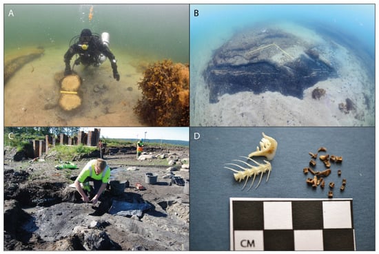
Figure 2.
(A) A pine stem protruding from organic sediments covered by sand at 4.9 m b.s.l. at Haväng. An organic sediment ridge can be seen to the left. (B) A stationary fishing construction made of hazel rods, dated to about 8500 cal BP, found at 6 m b.s.l. at Haväng. (C) Excavation of the fish fermentation pit at Norje Sunnansund. (D) Roach bones found at Norje Sunnansund. Photographs Arne Sjöström (A–B) Blekinge museum (C–D).
In order to assess the representativity of the Stone Age remains in the study area, it is important to consider the regional archaeological research history. Skåne is one of the most extensively investigated archaeological areas in Sweden. The province is well known for its abundance of Stone Age sites [78,79]. However, sites from the Pleistocene/Holocene transition are very few, not least in our study area, although the Late Weichselian findings from the Lake Finjasjön area in northern Skåne constitute an exception. An often proposed reason for the lack of sites from the final stage of the Late Weichselian is the cold climate during the Younger Dryas that forced human populations further south. However, a large number of coastal sites from the Late Palaeolithic, found in the westernmost part of southern Sweden, gives evidence of a cultural adaptation towards a marine economy during the later parts of the Younger Dryas [79]. If such a pattern of adaptation is applicable in the Hanö Bay area, all evidence lies in areas which today are inundated by the sea.
As in many parts of Sweden, systematic archaeological field surveys of Stone Age settlements in Blekinge began already during the late 19th century as part of a nationwide effort. Under the supervision of Knut Stjärna at Uppsala University, all provinces in Sweden were to be surveyed. This endeavor was not completed, but Blekinge was thoroughly surveyed and the results were later published by Erixon [80]. This “first wave” of archaeological interest was closely connected to Quaternary research and particularly to the study of early Holocene shoreline displacement. Several Mesolithic and Neolithic sites along the coast of Blekinge were excavated. These early research efforts were truly transdisciplinary, cf. [39,72,81,82,83,84,85]. Following a period of stagnation of Stone Age research, the area came into renewed interest during the late 20th century [86], mostly due to land exploitation and contract archaeology. This is mainly manifested along the newly constructed highway in the western part of Blekinge [87] and other constructions at Ljungaviken [73]. The Norje Sunnansund, Damm 6, Bro 597 and Lussabacken norr sites are closely co-located on the Listerlandet Peninsula, on the eastern shore of Ancient Lake Vesan, which was drained in the 19th century in order to create farmland [86] (Figure 1). Archaeological and geological excavations took place at the sites in 2011 in connection with a major road construction in the area (Figure 2). Today the sites are located about 2 km from the coast, and before the lake was drained, a nearby outlet stream connected the lake to the Baltic Sea [87].
3. Materials and Methods
Two sediment sequences were obtained from a small infilled lake basin adjacent to the Verkeån River; Öradekaren 1 in the centre of the basin (N 55° 43′ 14″; E 14° 11′ 19″), and Öradekaren 2 near the southern margin of the basin (N 55° 43′ 12″; E 14° 11′ 18″) (Figure 1). The sequences were sampled as 1 m sections using a Russian corer, with a section overlap of at least 0.1 m, yielding total sediment lengths of 4.9 and 3.3 m, respectively. The sediment sequences were investigated with several methods in order to reconstruct the local environmental development. 14C dates were obtained on six samples of terrestrial macroscopic plant remains, five and one from the Öradekaren 1 and 2 sequences, respectively, which were analyzed at the radiocarbon laboratory at Lund University. The 14C ages were calibrated using the INTCAL13 calibration data set [88] in the Oxcal 4.2.4 software [89]. Samples of loss-on-ignition were extracted at every 5 cm, with some adjustments to comply with lithological changes, throughout the sequences in order to assess the organic matter content, obtained through the methodology of [90]. Magnetic susceptibility was measured at every 5 mm with a Bartington Instruments MS2E1 surface scanning sensor connected to a Tamiscan-TS1 automatic logging conveyor in order to estimate the minerogenic matter content of the sediments. Samples for pollen analysis were obtained at 10 levels from the Öradekaren 1 sequence. These were prepared according to the methodology of Berglund and Ralska-Jasiewiczowa [91], with Lycopodium spore tablets added to the samples in order to estimate the pollen concentration [92]. Pollen concentrations were calculated based on the total sum of the counted pollen, including unidentified grains. A total of 300 to 500 pollen grains per sample were counted, except for two samples where about 200 grains were counted. The pollen stratigraphy was divided into four pollen assemblage zones based on marked pollen assemblage changes.
The shoreline displacement in the Haväng area was reconstructed based on 14C-dating of submerged rooted tree stumps, organic sediments and archaeological findings obtained along a transect from 4 to 20 m b.s.l. [6,7] (Figure 3). The shoreline displacement record for Blekinge was based on data from Haväng, adjusted for the differential isostatic uplift, and supported by 14C-dating of submerged rooted tree stumps, organic sediments and archaeological artefacts from depths in the range of 18 m b.s.l. to 5 m a.s.l. in western Blekinge [73,86,93] (Figure 3).

Figure 3.
Shoreline displacement record from Haväng (red line) [6], and a corresponding, interpolated record for western Blekinge (black line) [87] spanning the early and mid-Holocene.
The bathymetric data set covering the Hanö Bay was compiled by Aquabiota AB within the marine-ecological project MARMONI [94]. The data set consists of both multibeam and single beam echosounder measurements collected during the 1990s and 2000s, and has a spatial resolution of 10 m. However, in certain areas the spatial resolution is limited to 100 m due to military restrictions. Additional bathymetric data for the Haväng area were collected with a multibeam echo sounder during several occasions. The measurements were performed by the Swedish Maritime Administration (2009 and 2014) and Marin Mätteknik (MMT) (2012). The resulting data set was processed in the QPS Fledermaus 7.1 software in order to create a digital terrain model with a spatial resolution of 0.25 m [7]. The topographic data, based on LiDAR measurements, which were produced by the Swedish Mapping, Cadastral and Land Registration Authority (Lantmäteriet), has a spatial resolution of 2 m.
Shoreline reconstructions were made using the ArcGIS 10.3 software based on the shoreline displacement records from Haväng [6] and Blekinge [93]. Five palaeo-shoreline maps, showing the shoreline configuration during five key periods, were created; the Yoldia Sea lowstand, the Ancylus Lake transgression phase, the Ancylus Lake maximum, the Initial Littorina Sea minimum and the Littorina Sea transgression phase. The topographic data set was down-sampled to a spatial resolution of 10 m in order to make it compatible with the bathymetric data set before the two sets were merged into a seamless Digital Elevation Model (DEM). Due to the N-S difference in land uplift, and consequently tilted past shorelines, the DEM needed to be tilted perpendicular to the isobases in order to produce accurate past shorelines. The DEM tilt was performed by dividing the study area into segments in the E-W direction, following the shape of the isobases of [59], where each segment represents a water level change of 0.1 m; 76 segments for the Yoldia Sea lowstand and the Ancylus Lake transgression phase, 121 segments for the Ancylus Lake maximum, 91 segments for the Initial Littorina Sea lowstand and 56 segments for the Littorina Sea transgression phase. The segments cover the extent of the DEM and were used to divide the DEM into corresponding segments, allowing each segment to be manipulated with a value 0.1 m relative to its neighboring segments in order to create a smooth tilt of the reconstructed shorelines. A duplicate of each DEM segment was created and was given a different single elevation value corresponding to the level of the shoreline displacement for each segment, interpolated between the Haväng and Blekinge sites. The segment duplicate was then summed with its corresponding DEM segment (containing the present-day elevation data), which in effect moved the 0-value (shoreline) of the DEM relative to the present shoreline. Subsequently, the DEM segments were merged back into a single DEM and empty cells were filled by using an interpolation method where the empty cells were assigned values based on their nearest neighboring cells in a 5 × 5 cell matrix.
4. Results
The lowermost part of the Öradekaren 1 sequence consists of a sandy gyttja, which is overlain by clastic sediments from which one sample was 14C dated (Figure 4, Table 1 and Table 2). Organic sediments appear above the clastic layer. A sample from the lower part of the organic sediments was 14C dated (Table 2). A layer of fine to medium sand occurs at 422–400 cm, followed by a 350 cm thick succession of fine detritus gyttja. Two samples were from the gyttja were 14C dated, one just above the lower boundary and one at 300 cm (Table 2). The uppermost 50-cm part of the sequence consists of fen peat. A sample at the gyttja-peat boundary was 14C dated (Table 2). The organic matter content varies between about 1% and 20% in the lowermost 1.5-m part of the sequence (Figure 4). In the fine detritus gyttja the organic matter content varies between about 40% and 60%, whereas the content decreases within the peat in the uppermost 50 cm of the sequence. The magnetic susceptibility is relatively uniform throughout the sequence, but some minor peaks occur in the lowermost and uppermost parts, and values are generally higher in the peat.
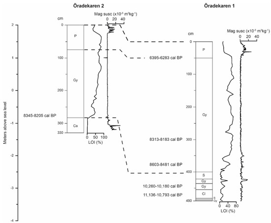
Figure 4.
Simplified lithostratigraphic columns, loss-on-ignition (LOI) and magnetic susceptibility from the Öradekaren 1 and Öradekaren 2 sequences. Facies abbreviations: P = fen peat, Gy = gyttja, Ca = calcareous sediment, S = sand, Cl = clay. Dashed lines indicate the proposed correlation between the sequences based on lithostratigraphic changes (Table 1 and Table 3) and 14C dating (Table 2).

Table 1.
Lithostratigraphy of the Öradekaren 1 sediment sequence. 14C dates are listed in Table 2.
Table 2.
Sample details and calibration results of 14C dates included in this study. The 14C ages were calibrated using the OxCal 4.2.4 software [89] and the INTCAL13 calibration data set [88]. The antler from Skräbeån River Mouth was found when dredging and therefore lacks elevation information.
Forty-five pollen taxa were identified in the pollen record (Figure 5). Zone 1, spanning the lowermost part of the stratigraphy (490–375 cm), is dominated by Pinus, Betula, Salix, Alnus, Corylus and Poaceae. Zone 2 (375–275 cm) is dominated by Pinus, but Alnus, Corylus, Quercus and Tilia are also represented among the tree taxa. Poaceae declines, whereas a large number of herb pollen taxa were recorded. In Zone 3 (275–75 cm), Pinus decreases drastically, while Alnus, Corylus and Ulmus increase. Myriophyllum increases, grasses and sedges are continuously low and the number of herb taxa increases slightly. Zone 4 (75–0 cm), is characterized by a general decline in total percentage of tree taxa, whereas herbs and grasses and sedges increase. The total pollen concentration in Zone 1 and 2 is about 104 grains cm3, considerably lower than in Zone 3 and 4 where the concentration is about 4 × 10⁴ grains cm3.

Figure 5.
Pollen percentage diagram for the Öradekaren 1 sequence. The recorded taxa are divided into five groups: trees, shrubs and dwarf-shrubs, herbs, grasses and sedges and water plants. The pollen record is divided into four pollen assemblage zones based on marked changes.
The lowermost 46-cm part of the Öradekaren 2 sequence consists of calcareous clay and silt followed at 284 cm by a 210 cm thick layer of fine detritus gyttja. The uppermost 74-cm part of the sequence consists of fen peat (Table 3). The organic matter content is close to 0% in the calcareous clay while it increases to about 50% in the lower part of the fine detritus gyttja and reaches approximately 80% in the upper part. The organic matter content decreases to about 50% in the fen peat. The magnetic susceptibility is stable throughout the sequence, but greatly elevated values occur in the lowermost part. The single 14C date at 278 cm, just above the transition from calcareous clay to gyttja, yielded an age of 8400–8200 cal BP (Table 2).
Table 3.
Lithostratigraphy of the Öradekaren 2 sediment sequence. 14C dates are listed in Table 2.
An antler tine from red deer (Cervus elaphus) found in dredged material at the site Skräbeån River Mouth yielded an age of 8800–8500 cal BP based on 14C-dating (Table 2) (Figure 1).
The shoreline reconstructions resulted in five palaeogeographic maps (Figure 6, Figure 7, Figure 8, Figure 9 and Figure 10) showing the effects of the shoreline fluctuations on the landscape in the Hanö Bay region during the early and mid-Holocene.
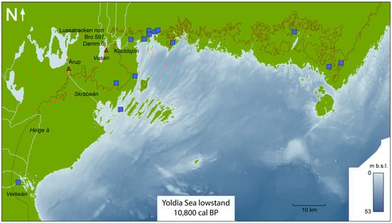
Figure 6.
Paleo-shoreline reconstruction of the study area during the Yoldia Sea lowstand. The red line represents the present coastline. Red triangles represent archaeological sites discussed in the text. Blue squares represent areas where submerged wood remains have been reported. Light blue lines represent rivers discussed in the text.
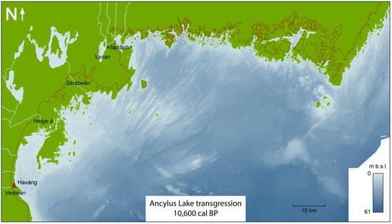
Figure 7.
Palaeo-shoreline reconstruction of the study area during the Ancylus Lake transgression. The red line represents the present coastline. The red triangle represents the archaeological site discussed in the text. Light blue lines represent rivers discussed in the text.
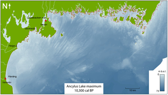
Figure 8.
Palaeo-shoreline reconstruction of the study area during the Ancylus Lake maximum. The red line represents the present coastline. The red triangle represents the archaeological site discussed in the text. Light blue lines represent rivers discussed in the text.

Figure 9.
Palaeo-shoreline reconstruction of the study area during the Initial Littorina Sea minimum. The red line represents the present coastline. Red triangles represent the archaeological site discussed in the text. Light blue lines represent rivers discussed in the text.
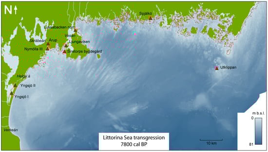
Figure 10.
Palaeo-shoreline reconstruction of the study area during the Littorina Sea transgression. The red line represents the present coastline. Red triangles represent the archaeological site discussed in the text. Light blue lines represent rivers discussed in the text.
5. Discussion
5.1. The Yoldia Sea Lowstand (c. 11,500–10,800 cal BP)
At the onset of the Holocene, at c. 11,700 cal BP [95], the Baltic Ice Lake was drained, its water level dropped by about 25 m during a period of only 1–2 years, and the Yoldia Sea was formed. Due to the subsequent rapid land uplift, southern Sweden experienced a continued regression during almost 1000 years after the drainage [2].
The bathymetric data set used for the reconstructions contains measurements from both single- and multibeam measurements. For modern multibeam measurements, the vertical error is less than one percent of the water depth [96]. Although the vertical error for older single beam measurements is likely to be slightly larger, the overall vertical uncertainty of the bathymetry data should be within 1 m, sufficient for our assessment of the regional-scale shore displacement. The possible errors of the individual shoreline displacement records, on which the palaeo-shoreline reconstructions are based, are discussed in [97].
The palaeo-shoreline reconstruction shows large exposed land areas east and south of the present coastline (Figure 6), confirmed at several sites by abundant wood remains, predominantly from pine, dating to this period. Extensive diving surveys at Haväng have shown the occurrence of the deepest rooted stump at 20.7 m b.s.l., indicating a mean water level of 24–25 m b.s.l. [6], and in Blekinge the corresponding minimum level was at about 20 m b.s.l. [93]. The Verkeån River had its outlet through a series of lagoons but this wetland was only exposed during a brief period at the absolute lowstand, while the area was a shallow bay during the majority of the Yoldia Sea Stage. The exposed coastal landscape at Haväng was characterized by an open pine woodland, as inferred from pollen data from lacustrine sediments at 17.5 m b.s.l. [6]. Further inland, the local topography and the clastic sediments with a negligible organic matter content in the lower part of the Öradekaren 1 sequence indicate that the basin was a poorly vegetated dead-ice hollow without influence of the Verkeån River (Figure 5). The small size of the basin implies that the pollen record represents the local vegetation, cf. [98], broadly consistent with corresponding data from the nearby submerged landscape at Haväng [6]. However, the number of taxa is considerably larger at Öradekaren, indicating that the newly exposed soils below the present sea level lacked the well-developed humus layer needed for the establishment of a rich terrestrial vegetation during the Yoldia Sea Stage.
North of Haväng, the bathymetry data reveal a relatively deep area stretching from the coastline and approximately 7 km to the east (Figure 1), indicating that rivers with outlets at the east coast of Skåne, including the large Helge Å River, merged in this lowland and ran south before reaching the coastline in the bay at Haväng. The bathymetry also reveals a distinct slope on the seafloor at 25–27 m b.s.l. (Figure 1), which may have formed by wave erosion during the Yoldia Sea lowstand.
The extent of Ancient Lake Vesan on the Listerlandet Peninsula was reconstructed based on its threshold at 0 m a.s.l. [86], and consequently, areas below the threshold level are interpreted as inundated by water (Figure 6). The Pukavik Bay was exposed during the Yoldia Sea Stage, but lacustrine sediments in corings at 17 m b.s.l. indicate the presence of a lake, named Lake Kladdsjön, the margins of which probably followed approximately the present-day 14 m b.s.l. depth contour [99]. Reconstructions of the river network in western Blekinge [93] indicate that a river drained Lake Vesan to the east through Lake Kladdsjön before it reached the coastline.
The large present-day lakes in the study area were added to the reconstructed palaeo-shoreline maps. Parts of Lake Hammarsjön were drained during the 19th century, but here the pre-drainage extent was reconstructed based on historical maps (obtained from the Swedish Mapping, Cadastral and Land Registration Authority historical map archive).
Few archaeological sites from the Preboreal have been found in southern Sweden, but the Årup site, located at the Skräbeån River, between Lake Ivösjön and the Baltic Sea coastline [74], the Lussabacken norr [100], Damm 6 and Bro 597 sites [101], situated on the eastern shore of Lake Vesan, constitute exceptions. At Årup, small windbreaks and flint remains with use-wear from butchering have been discovered, dating to the Yoldia Sea Stage. These findings suggest that the site was occupied during a very brief period, hours up to a few days, before the group moved on. At the nearby sites Lussabacken norr, Damm 6 and Bro 597, remains of huts and flint suggest a wide range of activities during temporary visits by humans.
There are no bones or other organic material from these sites providing evidence of the subsistence of the settlements. Based on subfossil material from other parts of southern Scandinavia, it has been established that most of the Holocene fauna had colonized the region by the Preboreal [102,103]. Several findings of depositions of elk (Alces alces) bones from this period in Denmark, such as Skottemarke, Favrbo and Lundby mosse suggest that elk was an important prey, but findings of butchered aurochs (Bos primigenius) and red deer bones demonstrate that hunting of other wild game also occurred [104,105]. Fish was likely an important resource as well and even though fish bones are rarely found at the few known sites with preserved organic material, the size and frailty of fish bones makes it plausible that they are absent for taphonomic and methodological reasons, cf. [106].
The lithic technology during the Preboreal from sites such as Damm 6 and Bro 597 show similarities with the Late Palaeolithic cultures and possibly a Palaeolithic lifestyle based on hunting of reindeer and other large game [100]. A compilation of 14C dates obtained on subfossil reindeer (Rangifer tarandus) show that the species occurred in southern Scandinavia throughout the Preboreal [107], although Preboreal archaeological sites with larger amounts of reindeer bones have yet to be found. In Denmark, it has been proposed that the transition from Palaeolithic to Mesolithic cultures did not occur until after the PBO, at c. 11,100 cal BP, when typical Preboreal forests were established [104].
All the known archaeological sites from this period reflect relatively small, probably seasonal camps, suggesting a society with small mobile groups of humans using different sites in the landscape for fishing, gathering of plants and hunting. However, all archaeological material comes from inland sites, and the former Yoldia Sea coastal zone is situated at about 10 to 20 m.b.s.l. today (Figure 6). Therefore, it is possible that large coastal settlements existed, but there is yet no evidence of this from the Hanö Bay region.
5.2. The Ancylus Lake Transgression (c. 10,800–10,300 cal BP)
Due to continued land uplift, the outlets of the Baltic Basin, west of Lake Vänern, in central Sweden became increasingly shallow, which forced the water level of the Baltic Basin to rise, marking the onset of the Ancylus Lake Stage [1]. The uneven uplift forced the water towards the south, and consequently, the southern parts of the Baltic Basin experienced a rapid transgression [2]. A reconstruction based on rooted stumps from Haväng determined the onset of the transgression to about 10,800 cal BP, and the water continued to rise at a rate of approximately 4 cm yr−1 for about 500 years, until a new southern outlet was established [6].
The rapid Ancylus Lake transgression led to monumental landscape changes over the course of a few centuries, most prominently expressed along the eastern shoreline of Skåne (Figure 7). Mid-way through the transgression, the bay at Haväng had widened and extended to the north, and a peninsula had formed east of the bay. During the transgression, the Verkeån River developed into a nutrient-rich and slow-flowing stream [6]. Findings of beaver (Castor fiber) bones suggest that parts of the river were dammed. Subfossil insect records obtained from submarine sediments at Haväng indicate open, exposed sandy soils and stagnant water [54]. Our pollen data from Öradekaren (Figure 5), as well as from the nearby submerged landscape indicate that the local vegetation was dominated by an open woodland, and the increased number of taxa at Haväng compared to the Yoldia Sea Stage indicates the development of a humus layer [6]. The transgression led to rising groundwater levels, continuously drowning trees near the shoreline [6], which left abundant dead and decaying pine trees as reflected by insect data [54].
The environmental changes at Haväng during the Ancylus Lake transgression seem to have resulted in the appearance of new rich habitats that attracted wild game and consequently humans to the area. Five bones of aurochs and three of beaver have been recovered from about 15 m.b.s.l. and 14C-dated to 10,700–10,400 cal BP [6]. Butchering marks and bone working on several of these bones demonstrate that they represent refuse from nearby settlements. The open pine-dominated woodland with abundant grassland, as inferred from pollen data, indicates suitable habitats for aurochs along the Verkeån River. There are only a few bone findings from Haväng so far, but contemporary findings from other parts of southern Scandinavia, such as the aurochs from Vig, located on northern Zealand in Denmark, with embedded microliths [108,109], show that aurochs were hunted during this period.
The setting of the archaeological sites by the Verkeån River mouth may imply that not only big game and beaver were hunted, but that aquatic resources, such as fish, were also of significance in the subsistence. However, contrary to later periods (see below), no findings of stationary fishing equipment have yet been recorded from the Ancylus Lake Stage, although future surveys and excavations could well reveal such structures [58]. The well-preserved cultural layers at Haväng have provided the only known organic artefacts from the Ancylus Lake Stage in the Hanö Bay region. Indeed, such sites are rare in southern Scandinavia in general, and in Sweden only two corresponding settlements are known, although they provide clear evidence of both terrestrial and marine resource utilization at this early stage; Almeö in south-central Sweden and Huseby Klev on the Swedish west coast. Apart from dogs, the mammal bone material from Almeö is dominated by elk, aurochs and wild boar (Sus scrofa). Freshwater fish is, despite poor preservation, abundant and the bone assemblage is dominated by pike (Esox lucius) and perch (Perca fluviatilis) [110]. The oldest occupation phase at Huseby Klev is dated to c. 10,000 cal BP. Here, the mammal bone material is dominated by marine animals, mainly white-beaker dolphin (Lagenorhynchus albirostris), porpoise (Phocoena phocoena) and seals (Phocidae), but also terrestrial game such as wild boar, while the fish bone assemblage is dominated by different cod species (Gadidae), mainly cod (Gadus morhua) [111].
In Blekinge, the Pukavik Bay started to form at this stage and developed into a lagoonal area where the relatively large Mörrumsån River and several smaller rivers had their outlets [93]. The transgression moved the coastline closer to Lake Vesan, and along the Blekinge coastline an archipelago started to appear, not least through the emergence of the Karlskronafjärden Bay and the subdivision of the Tärnölandet Peninsula (Figure 7). Similar to eastern Skåne, the vegetation in Blekinge was dominated by open pine woodlands, and charcoal from the settlement site Lussabacken norr shows that pine wood was used for fuel [112].
5.3. The Ancylus Lake Maximum (c. 10,300–9800 cal BP)
The maximum level of the Ancylus Lake was reached at about 10,300 cal BP [1], and beach ridges from this highstand can be found in eastern Blekinge [10]. At this stage, a southern outlet was established through the Store Belt Strait in Denmark, and the subsequent threshold erosion led to a gradual regression in the southern part of the Baltic Basin [113,114]. The regression continued until the water level of the Baltic Basin was at level with the world ocean at approximately 9800 cal BP.
In the southern part of the study area, the maximum Ancylus Lake water level was below the present shoreline (Figure 8). At Haväng, the coastline was located approximately 200 m east of the present shore. Here, only a worked red deer antler, dated to 10,200–9900 cal BP, is available from this period [7]. The pollen records suggest that the area was still dominated by an open pine woodland (Figure 5). In the marginal Öradekaren 2 sequence a basal layer of calcareous clay and silt was recorded, which contains Cretaceous fossils, likely brought to the site by glacial transport from sedimentary bedrock to the north. The calcareous deposits probably formed through precipitation from carbonate-rich groundwater seeping from the hillside at the edge of the basin. Similar deposits from the early Holocene, identified as tufas, have been found at other sites in Skåne, generally reflecting a relatively dry climate with high summer temperatures and low lake levels [115,116].
In Blekinge, where the maximum level reached above the present shoreline, narrow bays developed in the valleys and the islands of the archipelago became more isolated (Figure 8). Due to the high water level, Lake Vesan was in contact with the Ancylus Lake through a wide outlet to the east, and possibly also through the low-lying areas south of the lake. This reconstruction differs slightly from the one presented by Kjällquist et al. [86], where a higher maximum Ancylus Lake level was assumed, and therefore the Vesan area was interpreted as a lagoon. At Lussabacken norr, remains of a hut and flint material indicate human activity close to Lake Vesan during a short time just after the Ancylus Lake maximum [100]. This site was possibly a temporary shelter for a small group travelling by boat.
The rapid shoreline variations during the Ancylus Lake Stage, with a substantial transgression followed by a regression within a few hundred years (Figure 3), resulted in an ever-changing environment that humans had to adapt to. This could be one explanation for the few archaeological sites found from the period, since the shoreline was not suitable for long-term settlements at specific locations, instead allowing only short-term settlements.
5.4. The Initial Littorina Sea Minimum (c. 9800–8500 cal BP)
The first indications of saline intrusions into the Baltic Basin have been dated to approximately 9800 cal BP [43,117], demonstrating its definite connection to the world ocean. During this stage the water level was relatively stable in the Hanö Bay region over a period of about 1000 years [6], until the global eustasy exceeded the local isostasy at about 9000–8500 cal BP [1]. The lowermost level of the Initial Littorina Sea in Blekinge has previously been determined to just below the present water level [43], but new results indicate an even lower lowstand level [93] which was used in this reconstruction (Figure 3).
During the lowstand, the east coast of Skåne was located about 500 m east of the present shoreline (Figure 9). A highly productive freshwater lagoon with a slight brackish influence developed at the Verkeån River mouth at Haväng [7]. Mollusc and insect data indicate a stagnant or slow-flowing, shallow water body, while other insect remains demonstrate abundant decaying trees in the area [54]. Pollen data from the lagoon [7] and our new Öradekaren records indicate that the surrounding vegetation was dominated by a mixed woodland, characterized by both coniferous and deciduous trees. A sandy layer at 422–400 cm in the Öradekaren 1 sequence indicates a shallowing of the basin, possibly caused by a shift in the path of the adjacent Verkeån River, which could have eroded the outlet threshold of the basin, shifting the basin shore closer to the coring site. The 14C dates above and below the sand layer (Figure 4), and the large age difference between them, indicate that sediments below may have been eroded. Human exploitation of aquatic resources is evident in the form of several stationary fishing constructions at Haväng, dated to 9200–8400 cal BP, hinting at extensive fish consumption and a sedentary lifestyle [7].
Four bones of red deer, one grey seal (Halichoerus grypus) bone, a scapula and an antler pick axe of elk have been found at 6–8 m b.s.l., yielding ages in the range of 9000–8600 cal BP, contemporary with the fishing constructions [7]. The grey seal bone indicates the use of marine resources as a complement to the large-scale freshwater fishing. Five of the bones and antlers have cut marks or other work traces. Even though only a limited number of bones have been found so far, it is noteworthy that no bones of aurochs have been recorded, contrary to the material from the Ancylus Lake Stage. Possibly, this reflects a change in the environment to a more closed forest with less grassland, which is also evident from the pollen record. This vegetational development probably resulted in less favorable conditions for aurochs, while red deer became more common. A more permanent presence of humans could also have resulted in a higher hunting pressure and a decrease of aurochs. It has earlier been noted that few aurochs bones have been found at coastal settlements, while higher frequencies have been recorded at contemporary inland sites. This has been interpreted as a result of a higher hunting pressure in the coastal regions, which were probably more densely populated by humans [118,119]. Additionally at Norje Sunnansund, one of the few Early Mesolithic settlements from the coastal zone in southern Scandinavia, the frequency of aurochs bones is lower in comparison with contemporary inland sites from Skåne and eastern Denmark [87].
During the lowstand, many of the previously existing islands in the archipelago of eastern Blekinge were connected to the mainland. The Listerlandet Peninsula increased in extent, and especially in the south-west a large area was exposed. The extent of Lake Vesan decreased due to the regression, and a 2 km long outlet river connected the basin to the sea. At Norje Sunnansund, on the lake shore next to the outlet, a settlement was established at about 9600 cal BP. Here, the combination of archaeobotanical and zooarchaeological data provide evidence of a sedentary occupation, with intensification during autumn to spring [86], implying that the landscape was productive enough to support year-round use of the site. This was achieved by a high reliance on fish in the diet [120], which is also suggested to have been the case at contemporary coastal sites in other parts of southern Scandinavia [111,121], and is indeed suggested to have been a general and temporally increasing trend in southern Scandinavia throughout the early Holocene [122].
The slightly brackish conditions in the south-western part of the Baltic Sea created optimal conditions for catching certain freshwater fish species, e.g., roach (Rutilus rutilus), a species that can live in slightly brackish waters but requires access to upstream freshwaters for spawning [123]. These spawning congregations would generate a temporally limited abundance of roach in Lake Vesan, which could be exploited upon by using mass catching equipment, as demonstrated by the contemporaneous stationary fishing constructions at nearby Haväng, as mentioned above. Spawning congregations of roach and other freshwater fish species at different times of the year, enabled several mass catching opportunities, which, in combination with the large biomass associated with shallow eutrophic lakes [124], created favorable circumstances for a sedentary lifestyle at Norje Sunnansund [106]. However, even though fish can be extracted from freshwater systems all year round, some seasons are less productive and thus, in order to be able to use a settlement throughout the year, the large seasonal and temporally limited catches must be preserved and stored. A fermentation pit, where large amounts of predominantly roach were fermented and stored for later consumption provides evidence of preservation and mass storage, enabling a delayed return subsistence system [125]. Interestingly, the ability to ferment fish without the use of salt is among ethnographic societies only seen in polar areas [126], where it is colder than what can be assumed for Blekinge during this period, cf. [127].
The occupation of Norje Sunnansund is contemporaneous with the 9.3 kyr event, which was caused by large freshwater inputs into the North Atlantic, thereby temporarily decreasing the strength of the Atlantic meridional overturning circulation and lowering temperatures in the North Atlantic region [22]. The 9.3 kyr event is suggested to have been associated with a 40–100 year cooling in southern Scandinavia [19,22], enabling non-salted fermentation in the area for several generations. Lower than normal temperatures are supported by other zooarchaeological data from Norje Sunnansund. The age distribution of recovered seal bones from fetuses and newborn cubs suggests that seal mothers and their cubs were specially targeted and hunted from the ice during winter [87]. Especially findings of ringed seal (Pusa hispida) newborn cubs and fetuses provide further evidence of a colder winter climate than commonly assumed during the period in question [128], as female ringed seal give birth in snow caves on the sea ice [129]. As the sea ice in the region would not normally be thick enough for seal nesting, these data suggest that the 9.3 kyr event affected the area and that the inhabitants adapted to the changing climate conditions.
From Norje Sunnansund there is evidence not only of hunting and fishing but also of plant gathering, particularly of hazelnuts, but also berries of dogwood, raspberry, bird cherry and hawthorn [111]. The earliest hazelnuts from the settlement are dated to c. 9500 cal BP, which coincides with a strong increase in abundance of hazel in the area according to pollen data. The relatively stable coastline over a period of about 1000 years during the Initial Littorina Sea Stage meant that coastal settlements were more likely inhabited during longer periods, which, together with the development of productive aquatic habitats, might have acted as a catalyst for the sedentary lifestyle recorded at the Haväng and Norje Sunnansund sites.
At Årup, located about 5 km from the Initial Littorina Sea coastline, remains of a windbreak indicate the presence of a temporary field camp representing an event of very short duration [74]. This shows that other types of seasonal sites were used contemporaneous with the coastal Haväng and Norje Sunnansund settlements, where a more sedentary lifestyle was probably practiced. In fact, the recently encountered archaeological site Skräbeån River Mouth, just 5 km downstream from the Årup site could well be the evidence of another less permanent settlement location during the Early Littorina Stage. Inland sites located by lakes have been excavated in other parts of southern Scandinavia. Many of which indicate that they were used for hunting and gathering mainly during the summer and early autumn [130,131,132]. This pattern is part of a larger South Scandinavian trend during the Early and Middle Mesolithic where a homogenization of the subsistence strategies and an increasingly territorial use of the landscape is seen [106,122]. Here, larger settlements are suggested to have been located close to productive water bodies while, during the Early Mesolithic period, the more common inland sites are often seen as seasonal, though revisited, terrestrial large game hunting camps [106].
5.5. The Littorina Sea Transgression (8500–6000 cal BP)
The onset of the Littorina Sea transgression has been dated to approximately 8500 cal BP in Blekinge [43], and, due to the lower land uplift rate, a few hundred years earlier in the southern part of the study area [6]. The transgression led to the opening of the Öresund Strait, and larger amounts of saline water started to enter the Baltic Basin [43]. The water level continued to rise until about 6000 cal BP when the level of the world ocean stabilized.
The Littorina transgression dramatically reshaped the landscape of the study area (Figure 10). At Haväng, the onset of the transgression is reflected in the diatom and elemental records of lagoonal sediments at about 8600 cal BP [7]. The pollen data from Öradekaren indicate the establishment of a deciduous forest, but despite an increase in the number of herb taxa the vegetation became more closed. A thick layer of fine detritus gyttja, rich in organic matter (Figure 4), started to deposit in the Öradekaren basin at about 8500 cal BP, suggesting a water depth of at least 2–3 m and a decreased influence of the flow of the Verkeån River. Possibly, the basin became an oxbow lake cut off from the meandering river. In the Öradekaren 2 sequence, located in the peripheral part of the same basin, a fining-upwards detritus gyttja was deposited as a result of the Littorina transgression. Eventually the basin became connected to the sea, although the protected location in a small bay enabled continued gyttja deposition. Herb taxa such as Caltha, Filipendula and Humulus indicate moist marginal conditions during the transgression period, whereas the water plants Hottonia palustris and Myriophyllum verticillatum indicate a relatively shallow water body. The fen peat deposited in the uppermost part of the Öradekaren sequences shows that the basin was infilled with sediments and eventually overgrown at about 6300 cal BP, accompanied by an opening of the immediately surrounding landscape, as indicated by the decrease in tree pollen frequencies and the increases in herbs, grasses and sedges of Zone 4 (Figure 5).
At Lussabacken norr, a winter camp, dated to 8500–8300 cal BP, has been found, consisting of robust huts and probable canoe chutes [100]. Charred hazelnuts and a seed of dogwood from the huts reflect plant gathering [112]. The surrounding woodlands were dominated by pine, hazel and elm, with alder along lakes and in wetlands. The Littorina transgression submerged large parts of the Listerlandet Peninsula, and a preserved alder stump dated to about 8000 cal BP from the shore of Lake Vesan indicates that the Norje Sunnansund and Lussabacken norr settlements became transgressed at this stage. On the western side of the Listerlandet Peninsula, the Ljungaviken settlement, which has been dated to 8700–7700 cal BP, was located on sandy soils close to the contemporary shoreline of the Littorina Sea, surrounded by pine, oak and alder forest [73]. The settlement was used repeatedly within this period, and findings of raspberry and bearberry seeds, together with the absence of hazelnuts, indicate that the site was mainly inhabited during summer [133]. The oldest activity indicates sporadic visits in an inland setting, and it was not until the transgression transformed the settlement into an island or peninsula that the site became more permanent. The settlement was finally transgressed at about 7700 cal BP. At Årup, two excavated areas with an overlapping age range of 8400–8200 cal BP indicate, if contemporaneous, a large settlement with several units of huts and workshops was inhabited during a short period [74]. A part of the site was a specialized workshop for manufacturing of flint-edged tools. At the Skräbeån River outlet, situated about 2 km downstream of the Årup settlement, the coastal site Nymölla III has been found. The settlement has been dated to about 7300–6600 cal BP, but it was also inhabited during the Early Neolithic. Large game, mainly red deer, roe deer and wild boar, along with fur animals, were hunted. However, marine resources, such as grey and ringed seal, as well as fish in the form of cyprinids (Cyprinidae), pike and cod, were also included in the subsistence [75].
Other noteworthy findings include a harpoon made of red deer antler from the remote Utklippan Island, dated to 8400–8000 cal BP [134] and a fine barbed leister prong made of elk bone from Spjälkö, dated to about 7500 cal BP [42]. At Yngsjö, a site (Yngsjö I) dated to 8200–8000 cal BP was found south of the Helge Å River outlet (Figure 10), while a younger site (Yngsjö II), dated to about 7500 cal BP, was found north of the outlet [76]. From the younger site, large quantities of bones from lacustrine fish were recovered, indicating that even after the opening of the Öresund strait, the humans in the Hanö Bay area still relied on freshwater fishing. However, there is also some evidence from Yngsjö of the use of marine resources from the Littorina Sea, such as porpoise, grey and ringed seals, European flounder (Platichthys flesus) and turbot (Scophthalmus maximus) [135].
Findings of bones of newborn ringed seals from Yngsjö indicate the reproduction of seals close to the settlement. As mentioned above, ringed seals normally make snow caves on the sea ice to give birth to their young [129]. Additionally, new findings of ringed seal bones have been made at Nymölla III [75]. These findings may indicate periods of cold winters during the Holocene Thermal Maximum in the Hanö Bay region, which resulted in sea ice formation. However, it cannot be excluded that the sites were in use during 8.2 kyr event, when temporarily colder conditions could have led to extensive winter sea-ice. The effects of the 8.2 kyr event on the local vegetation at Haväng were not possible to detect in the pollen data set, possibly due to the relatively low sample density. To what extent the 8.2 kyr event affected human populations and settlement patterns in the Hanö Bay region is uncertain. However, 14C dating indicates that the Ljungaviken settlement was occupied around the time of the event [73]. Large series of 14C dates from other sites in southern Sweden, such as Tågerup, in western Skåne, and Ringsjöholm, in central Skåne, also demonstrate continuous human occupation during an extended period including the 8.2 kyr event [118,136]. This does not mean that the cold event did not have any impact on the humans and their living conditions, but there is no evidence implying that the change in climate resulted in altered subsistence or abandonment of settlements in the Hanö Bay region and adjacent areas. Recent studies suggest that the 8.2 kyr event had a lesser impact on the North European societies than previously thought [31] and that there might be a high level of resilience to climate events in coastal areas, as seen in southern Norway [29,137].
At Siretorp on Listerlandet, Blekinge, a large settlement complex was established during the time of the Littorina Sea transgression [72,138]. Recent archaeological excavations at Siretorps bygdegård, 2 km N of Siretorp, have revealed remains of several hearths and well-preserved huts together with a large amount of lithic material, dated to 8000–7000 cal BP, with most dates concentrated around 8000–7600 cal BP [139]. The large Siretorp settlement, excavated mainly in the early 1900s and in 1971, dates to the Late Mesolithic, about 7000–6000 cal BP, and the Neolithic, about 5000–4000 cal BP. The settlement was located on an island, facing the sea, and the dominance of seal bones indicates a shift in the subsistence towards a focus on marine resources from the Littorina Sea [72,140].
6. Conclusions
This study shows that the combination of palaeoecological and zooarchaeological investigations can greatly enhance the research output by providing detailed and integrated results regarding the interplay between human populations and the landscape they inhabit and rely on for their subsistence.
The new, detailed palaeo-shoreline reconstructions for the Hanö Bay area presented here illustrate the rapid transformation of the coastal landscape during the early to mid-Holocene, caused not only by changes in shoreline position related to water-level changes, but also by changes in the location of rivers and lakes. These changes, in combination with the successive immigration of new taxa during the early Holocene, resulted in a truly dynamic vegetational development in the coastal regions of southern Sweden.
Our results demonstrate a transition from a Palaeolithic lifestyle, characterized by easily movable campsites at temporarily favorable locations, towards a more sedentary lifestyle with a high reliance of fish in the diet. This transition coincides with the development of productive coastal environments and a relatively stable shoreline position during the Initial Littorina Sea Stage. Stationary fishing constructions and evidence of food preservation indicate a delayed return subsistence, involving a year-round presence in these coastal landscapes. Hence, territoriality may have become more important when the subsistence started to rely on freshwater fish. There is, so far, no evidence of major population declines or shifting subsistence strategies in the region during the 9.3 and 8.2 kyr cooling events.
Our multi-disciplinary approach, which has provided novel insight into human behavior, resource exploitation and settlement pattern in relation to changes of shorelines and paleoenvironment during the Mesolithic, can probably be applied in a wide range of contexts and regions.
Author Contributions
Conceptualization, A.H.; Investigation, A.H., D.H., A.N.B., M.R., B.N. and O.M.; Writing—original draft presentation, A.H., A.B., O.M. and P.L.; Writing—review and editing, M.R., D.H., A.N.B. and B.N.; Methodology; A.H.; Funding acquisition, A.H. and B.N.
Funding
This research was funded by the Royal Physiographic Society of Lund (2016, 2017) and the Swedish Research Council (2016-02027).
Acknowledgments
We thank Marin Mätteknik AB (MMT) and the Swedish Maritime Administration for the multibeam echo sounding measurements of the Haväng area. Hans Linderson is acknowledged for assistance with the field work at Öradekaren. Five anonymous reviewers are greatly acknowledged for their valuable comments on the manuscript.
Conflicts of Interest
The authors declare no conflict of interest.
References
- Andrén, T.; Björck, S.; Andrén, E.; Conley, D.; Zillén, L.; Anjar, J. The Development of the Baltic Sea Basin During the Last 130 Ka. In The Baltic Sea Basin; Harff, J., Björck, S., Hoth, P., Eds.; Springer: Heidelberg, Germany, 2011; pp. 75–98. [Google Scholar]
- Björck, S. A Review of the History of the Baltic Sea, 13.0–8.0 Ka BP. Quat. Int. 1995, 27, 19–40. [Google Scholar] [CrossRef]
- Rosentau, A.; Bennike, O.; Uścinowicz, S.; Miotk-Szpiganowicz, G. The Baltic Sea Basin. In Submerged Landscapes of the European Continental Shelf. Quaternary Paleoenvironments; Flemming, N.C., Harff, J., Moura, D., Burgess, A., Bailey, G., Eds.; Wiley Blackwell: Chichester, UK, 2017; pp. 103–134. [Google Scholar]
- Fischer, A. Coastal Fishing in Stone Age Denmark—Evidence from Below and above the Present Sea Level and from Human Bones. In Shell Middens and Coastal Resources along the Atlantic; Milner, N., Bailey, G., Craig, O., Eds.; Oxbow Books: Oxford, UK, 2007; pp. 54–69. [Google Scholar]
- Goldhammer, J.; Hartz, S. Fished up from the Baltic Sea: A New Ertebölle Site near Stohl Cliff, Kiel Bay, Germany. In Under the Sea: Archaeology and Palaeolandscapes of the Continental Shelf; Bailey, G.N., Harff, J., Sakellariou, D., Eds.; Springer: Cham, Switzerland, 2017; pp. 145–154. [Google Scholar]
- Hansson, A.; Björck, S.; Heger, K.; Holmgren, S.; Linderson, H.; Magnell, O.; Nilsson, B.; Rundgren, M.; Sjöström, A.; Hammarlund, D. Shoreline Displacement and Human Resource Utilization in the Southern Baltic Basin Coastal Zone During the Early Holocene: New Insights from a Submerged Mesolithic Landscape in South-Eastern Sweden. Holocene 2018, 28, 721–737. [Google Scholar] [CrossRef]
- Hansson, A.; Nilsson, B.; Sjöström, A.; Björck, S.; Holmgren, S.; Linderson, H.; Magnell, O.; Rundgren, M.; Hammarlund, D. A Submerged Mesolithic Lagoonal Landscape in the Baltic Sea, Southeastern Sweden—Early Holocene Environmental Reconstruction and Shore-Level Displacement Based on a Multiproxy Approach. Quat. Int. 2018, 463, 110–123. [Google Scholar] [CrossRef]
- Hartz, S.; Jöns, H.; Lübke, H.; Schmölcke, U.; von Carnap-Bornheim, C.; Heinrich, D.; Klooß, S.; Lüth, F.; Wolters, S. Prehistoric Settlements in the South-Western Baltic Sea Area and Development of the Regional Stone Age Economy. In Sincos II—Sinking Coasts: Geosphere, Ecosphere and Anthroposphere of the Holocene Southern Baltic Sea; Harff, J., Lüth, F., Eds.; Verlag Philipp von Zabern: Darmstadt, Germany, 2014; pp. 77–210. [Google Scholar]
- Uścinowicz, S.; Miotk-Szpiganowicz, G.; Krapiec, M.; Witak, M.; Harff, J.; Lübke, H.; Tauber, F. Drowned Forests in the Gulf of Gdańsk (Southern Baltic) as an Indicator of the Holocene Shoreline Changes. In The Baltic Sea Basin; Harff, J., Björck, S., Hoth, P., Eds.; Springer: Heidelberg, Germany, 2011; pp. 219–231. [Google Scholar]
- Mikaelsson, J. Strandvallskomplexet Vid Olsäng. Blekinges Natur 1978, 1, 37–52. [Google Scholar]
- Munthe, H. Beskrifning Till Kartbladet Ottenby; Serie Ac 7; Sveriges Geologiska Undersökning: Stockholm, Sweden, 1902; p. 68.
- Muru, M.; Rosentau, A.; Preusser, F.; Plado, J.; Sibul, I.; Joelath, A.; Bjursäter, S.; Aunap, R.; Kriiska, A. Reconstructing Holocene Shore Displacement and Stone Age Palaeogeography from a Foredune Sequence on Ruhnu Island, Gulf of Riga, Baltic Sea. Geomorphology 2018, 303, 434–445. [Google Scholar] [CrossRef]
- Rosentau, A.; Muru, M.; Kriiska, A.; Subetto, D.A.; Vassiljev, J.; Hang, T.; Gerasimov, D.; Nordqvist, K.; Ludikova, A.; Lougas, L.; et al. Stone Age Settlement and Holocene Shore Displacement in the Narva-Luga Klint Bay Area, Eastern Gulf of Finland. Boreas 2013, 42, 912–931. [Google Scholar] [CrossRef]
- Tikkanen, M.; Oksanen, J. Late Weichselian and Holocene Shore Displacement History of the Baltic Sea in Finland. Fennia 2002, 180, 9–20. [Google Scholar]
- Antonsson, K.; Seppä, H. Holocene Temperatures in Bohuslän, Southwest Sweden: A Quantitative Reconstruction from Fossil Pollen Data. Boreas 2007, 36, 400–410. [Google Scholar] [CrossRef]
- Seppä, H.; Hammarlund, D.; Antonsson, K. Low-Frequency and High-Frequency Changes in Temperature and Effective Humidity during the Holocene in South-Central Sweden: Implications for Atmospheric and Oceanic Forcings of Climate. Clim. Dyn. 2005, 25, 285–297. [Google Scholar] [CrossRef]
- Hammarlund, D.; Björck, S.; Buchardt, B.; Israelson, C.; Thomsen, C.T. Rapid Hydrological Changes During the Holocene Revealed by Stable Isotope Records of Lacustrine Carbonates from Lake Igelsjön, Southern Sweden. Quat. Sci. Rev. 2003, 22, 353–370. [Google Scholar] [CrossRef]
- Björck, S.; Rundgren, M.; Ingolfsson, O.; Funder, S. The Preboreal Oscillation around the Nordic Seas: Terrestrial and Lacustrine Responses. J. Quat. Sci. 1997, 12, 455–465. [Google Scholar] [CrossRef]
- Rasmussen, S.O.; Vinther, B.M.; Clausen, H.B.; Andersen, K.K. Early Holocene Climate Oscillations Recorded in Three Greenland Ice Cores. Quat. Sci. Rev. 2007, 26, 1907–1914. [Google Scholar] [CrossRef]
- Bos, J.A.A.; van Geel, B.; van der Plicht, J.; Bohncke, S.J.P. Preboreal Climate Oscillations in Europe: Wiggle-Match Dating and Synthesis of Dutch High-Resolution Multi-Proxy Records. Quat. Sci. Rev. 2007, 26, 1927–1950. [Google Scholar] [CrossRef]
- van der Plicht, J.; van Geel, B.; Bohncke, S.J.P.; Bos, J.A.A.; Blaauw, M.; Sperenza, A.O.M.; Muscheler, R.; Björck, S. The Preboreal Climate Reversal and a Subsequent Solar-Forced Climate Shift. J. Quat. Sci. 2004, 19, 263–269. [Google Scholar] [CrossRef]
- Fleitmann, D.; Mudelse, M.; Burns, S.J.; Bradley, R.S.; Kramers, J.; Matter, A. Evidence for a Widespread Climatic Anomaly at around 9.2 Ka before Present. Paleoceanography 2008, 23, PA1102. [Google Scholar] [CrossRef]
- Daley, T.J.; Thomas, E.R.; Holmes, J.A.; Street-Perrott, F.A.; Chapman, M.R.; Tindall, J.C.; Valdes, P.J.; Loader, N.J.; Marshall, J.D.; Wolff, E.W.; et al. The 8200 Yr BP Cold Event in Stable Isotope Records from the North Atlantic Region. Glob. Planet. Chang. 2011, 79, 288–302. [Google Scholar] [CrossRef]
- Kobashi, T.; Severinghaus, J.P.; Brooks, E.J.; Barnola, J.M.; Grachev, A.M. Precise Timing and Characterization of Abrupt Climate Change 8200 Years Ago from Air Trapped in Polar Ice. Quat. Sci. Rev. 2007, 26, 1212–1222. [Google Scholar] [CrossRef]
- Alley, R.B.; Ágústsdóttir, A.M. The 8k Event: Cause and Consequences of a Major Holocene Abrupt Climate Change. Quat. Sci. Rev. 2005, 24, 1123–1149. [Google Scholar] [CrossRef]
- Yu, S.Y.; Colman, S.M.; Lowell, T.V.; Milne, G.A.; Fisher, T.G.; Breckenridge, A.; Boyd, M.; Teller, J.T. Freshwater Outburst from Lake Superior as a Trigger for the Cold Event 9300 Years Ago. Science 2010, 328, 1262–1266. [Google Scholar] [CrossRef]
- Groß, D.; Zander, A.; Boethius, A.; Dreibrodt, S.; Grøn, O.; Hansson, A.; Jessen, C.; Koivisto, S.; Larsson, L.; Lübke, H.; et al. People, Lakes and Seashores: Studies from the Baltic Sea Basin and Adjacent Areas in the Early and Mid-Holocene. Quat. Sci. Rev. 2018, 185, 27–40. [Google Scholar] [CrossRef]
- Bohncke, S.J.P.; Hoek, W.Z. Multiple Oscillations during the Preboreal as Recorded in a Calcareous Gyttja, Kingbeekdal, the Netherlands. Quat. Sci. Rev. 2007, 26, 1965–1974. [Google Scholar] [CrossRef]
- Breivik, H.M.; Fossum, G.; Solheim, S. Exploring Human Responses to Climatic Fluctuations and Environmental Diversity: Two Stories from Mesolithic Norway. Quat. Int. 2018, 465, 258–275. [Google Scholar] [CrossRef]
- Crombé, P. Abrupt Cooling Events during the Early Holocene and Their Potential Impact on the Environment and Human Behaviour along the Southern North Sea Basin (NW Europe). J. Quat. Sci. 2018, 33, 353–367. [Google Scholar] [CrossRef]
- Griffiths, S.; Robinson, E. The 8.2 Ka BP Holocene Climate Change Event and Human Population Resilience in Northwest Atlantic Europe. Quat. Int. 2018, 465, 251–257. [Google Scholar] [CrossRef]
- Persson, C. Den Hemliga Sjön: En Resa Till Det Småländska Inlandet För 9000 År Sedan; Gothenburg Archaeological Theses: Gothenburg, Sweden, 2012; p. 294. [Google Scholar]
- Robinson, E.; Van Strydonck, M.; Gelorini, V.; Crombé, P. Radiocarbon Chronology and the Correlation of Hunteregatherer Sociocultural Change with Abrupt Palaeoclimate Change: The Middle Mesolithic in the Rhine-Meuse-Scheldt Area of Northwest Europe. J. Archaeol. Sci. 2013, 40, 755–763. [Google Scholar] [CrossRef]
- Wicks, K.; Mithen, S. The Impact of the Abrupt 8.2 Ka Cold Event on the Mesolithic Population of Western Scotland: A Bayesian Chronological Analysis Using ‘Activity Events’ as a Population Proxy. J. Archaeol. Sci. 2014, 45, 240–269. [Google Scholar] [CrossRef]
- De Geer, G. Om En Postglacial Landsänkning I Södra Och Mellersta Sverige; Serie C 52; Sveriges Geologiska Undersökning: Stockholm, Sweden, 1882; p. 16.
- Holst, N.O. Bidrag Till Kännedomen Om Östersjöns Och Bottniska Vikens Postglaciala Geologi; Serie C 180; Sveriges Geologiska Undersökning: Stockholm, Sweden, 1899; p. 128.
- Sandegren, R. Torvgeologisk Och Pollenanalytisk Undersökning Av Torvmarken N Intill Boplatskomplexet Vid Siretorp. In Stenåldersboplatserna Vid Siretorp I Blekinge; Bagge, A., Kjellmark, K., Eds.; Kungliga Vitterhets Historie och Antikvitets Akademien: Stockholm, Sweden, 1939; pp. 251–256. [Google Scholar]
- Nilsson, E. Om Södra Sveriges Senkvartära Historia. Geologiska Föreningen i Stockholm Förhandlingar 1953, 75, 155–246. [Google Scholar] [CrossRef]
- Berglund, B.E. The Post-Glacial Shore Displacement in Eastern Blekinge, Southeastern Sweden; Serie C 599; Sveriges Geologiska Undersökning: Stockholm, Sweden, 1964; p. 47.
- Björck, S. Late Weichselian Stratigraphy of Blekinge, SE Sweden, and Water Level Changes in the Baltic Ice Lake. Lundqua thesis 7. Ph.D. Thesis, Lund University, Lund, Sweden, 1979; p. 248. [Google Scholar]
- Björck, S. A Stratigraphic Study of Late Weichselian Deglaciation, Shore Displacement and Vegetation History in South-Eastern Sweden. Fossils Strata 1981, 14, 3–91. [Google Scholar]
- Liljegren, R. Paleoekologi Och Strandförskjutning I En Littorinavik Vid Spjälkö I Mellersta Blekinge. Lundqua Thesis 11. Ph.D. Thesis, Lund University, Lund, Sweden, 1982; p. 95. [Google Scholar]
- Berglund, B.E.; Sandgren, P.; Barnekow, L.; Hannon, G.; Jiang, H.; Skog, G.; Yu, S.H. Early Holocene History of the Baltic Sea, as Reflected in Coastal Sediments in Blekinge, Southeastern Sweden. Quat. Int. 2005, 130, 111–139. [Google Scholar] [CrossRef]
- Andrén, T.; Andrén, E.; Berglund, B.E.; Yu, S.H. New Insights on the Yoldia Sea Low Stand in the Blekinge Archipelago, Southern Baltic Sea. Geologiska Föreningen i Stockholm Förhandlingar 2007, 129, 277–285. [Google Scholar] [CrossRef]
- Yu, S.Y.; Berglund, B.E.; Sandgren, P.; Lambeck, K. Evidence for a Rapid Sea-Level Rise 7600 Yr Ago. Geology 2007, 35, 891–894. [Google Scholar] [CrossRef]
- Nilsson, T. Die Pollenanalyti-Sche Zonengliederung Der Spät- Und Postglazialen Bildungen Schonens. Geologiska Föreningen i Stockholm Förhandlingar 1935, 57, 385–562. [Google Scholar] [CrossRef]
- Berglund, B.E. Late-Quaternary Vegetation in Eastern Blekinge, South-Eastern Sweden. I. Late-Glacial Time; Opera Botanica 12:1; Almqvist & Wiksell: Stockholm, Sweden, 1966; p. 180. [Google Scholar]
- Berglund, B.E. Late-Quaternary Vegetation in Eastern Blekinge, South-Eastern Sweden. II. Post-Glacial Time; Opera Botanica 12:2; Almqvist & Wiksell: Stockholm, Sweden, 1966; p. 190. [Google Scholar]
- Gaillard, M.J. A Palaeohydrological Study of Krageholmssjön (Scania, South Sweden). Regional Vegetation History and Water-Level Changes; Lundqua Report 25; Lund University: Lund, Sweden, 1984; p. 40. [Google Scholar]
- Nilsson, T. Ravlundafältets Geologi. Skånes Natur 1961, 1, 73–106. [Google Scholar]
- Hansen, L. Hanöbuktens Forntida Miljö. Resultat Och Redovisning Av Marina Undersökningar Mellan Den 2—16 Juni 1985; Lars Hansen: Malmö, Sweden, 1985; p. 16. [Google Scholar]
- Hansen, L. Hanöbuktens Forntida Miljö. Forskningsprogram; Lars Hansen: Malmö, Sweden, 1986; p. 13. [Google Scholar]
- Björck, S.; Dennegård, B.; Sandgren, P. The Marine Stratigraphy of the Hanö Bay, SE Sweden, Based on Different Sediment Stratigraphic Methods. Geologiska Föreningen i Stockholm Förhandlingar 1990, 112, 265–280. [Google Scholar] [CrossRef]
- Gaillard, M.J.; Lemdahl, G. Early-Holocene Coastal Environments and Climate in Southeast Sweden: A Reconstruction Based on Macrofossils from Submarine Deposits. Holocene 1994, 4, 53–68. [Google Scholar] [CrossRef]
- Hansen, L. Submerged Mesolithic Landscapes. Preliminary Results from the Hanö Bay, Southern Baltic. In Man & Sea in the Mesolithic; Fischer, A., Ed.; Oxbow books: Oxford, UK, 1995; pp. 409–414. [Google Scholar]
- Holmlund, J.; Nilsson, B.; Rönnby, J. Joint Explorations of the Sunken Past. Examples of Maritime Archaeological Collaboration between Industry and Academia in the Baltic. In Under the Sea: Archaeology and Palaeolandscapes of the Continental Shelf; Bailey, G., Harff, J., Sakellariou, D., Eds.; Springer: Cham, Switzerland, 2017; pp. 53–63. [Google Scholar]
- Nilsson, B.; Sjöström, A. Ån På Havets Botten: Geologisk Bakgrund Och Arkeologisk Framtid För Havängsundersökningarna. Österlent 2013, 1, 19–21. [Google Scholar]
- Nilsson, B.; Sjöström, A.; Persson, P. Seascapes of Stability and Change: The Archaeological and Ecological Potential of Early Mesolithic Seascapes, with Examples from Haväng in the Southern Baltic, Sweden. In The Ecology of Early Settlement in Northern Europe—Conditions for Subsistence and Survival; Persson, P., Skar, B., Breivik, H.M., Riede, F., Jonsson, L., Eds.; Equinox: Sheffield, UK, 2018; pp. 335–352. [Google Scholar]
- Ågren, J.; Svensson, R. Postglacial Land Uplift Model and System Definition for the New Swedish Height System Rh 2000; Lmv-Rapport 2007:4; Lantmäteriet: Gävle, Sweden, 2007; p. 124.
- Ångström, A. Sveriges Klimat; Generalstabens Litografiska Anstalts Förlag: Stockholm, Sweden, 1974; p. 106. [Google Scholar]
- Kornfält, K.-A.; Bergström, J. Beskrivning Till Berggrundskartorna Karlshamn SV Och SO; Serie Af 167–168; Sveriges Geologiska Undersökning: Uppsala, Sweden, 1990; p. 74.
- Kornfält, K.-A. Beskrivning Till Berggrundskartan Karlskrona NV/SV; Serie Af 179; Sveriges Geologiska Undersökning: Uppsala, Sweden, 1993; p. 56.
- Kornfält, K.-A. Beskrivning Till Berggrundskartan 3f Karlskrona SO; Serie Af 205; Sveriges Geologiska Undersökning: Uppsala, Sweden, 1999; p. 59.
- Kornfält, K.-A. Beskrivning Till Berggrundskartan 3f Karlskrona NO; Serie Af 199; Sveriges Geologiska Undersökning: Uppsala, Sweden, 1999; p. 73.
- Erlström, M.; Sivhed, U.; Wikman, H.; Kornfält, K.-A. Beskrivning Till Berggrundskartorna 2d Tomelilla NV, NO, SV, SO 2e Simrishamn NV, SV 1d Ystad NV, NO 1e Örnhusen NV; Sveriges Geologiska Undersökning: Uppsala, Sweden, 2004; p. 141.
- Kornfält, K.-A.; Bergström, J.; Carserud, L.; Henkel, H.; Sundquist, B. Beskrivning Till Berggrundskartan Och Flygmagnetiska Kartan Kristianstad SO; Serie Af 121; Sveriges Geologiska Undersökning: Uppsala, Sweden, 1978; p. 120.
- Stroeven, A.P.; Hättestrand, C.; Kleman, J.; Heyman, J.; Fabel, D.; Fredin, O.; Goodfellow, B.W.; Harbor, J.M.; Jansen, J.D.; Olsen, L.; et al. Deglaciation of Fennoscandia. Quat. Sci. Rev. 2016, 147, 91–121. [Google Scholar] [CrossRef]
- Larsson, I. Anisotropy in Precambrian Rocks and Post-Crystalline Deformation Models. Geogr. Annal. Ser. A Phys. Geogr. 1967, 49, 237–246. [Google Scholar] [CrossRef]
- Persson, M. Beskrivning Till Jordartskartan 3e Karlshamn SO; Serie Ae 116; Sveriges Geologiska Undersökning: Uppsala, Sweden, 1995; p. 76.
- Persson, M. Beskrivning Till Jordartskartan 3e Karlshamn NO; Serie Ae 138; Sveriges Geologiska Undersökning: Uppsala, Sweden, 2000; p. 51.
- Persson, M.; Malmberg Persson, K. Beskrivning Till Jordartskartorna 3f Karlskrona NO Och SO; Serie K 532–533; Sveriges Geologiska Undersökning: Uppsala, Sweden, 2016; p. 74.
- Bagge, A.; Kjellmark, K. Stenåldersboplatserna Vid Siretorp I Blekinge; Kungliga Vitterhets Historie och Antikvitets Akademien: Stockholm, Sweden, 1939; p. 405. [Google Scholar]
- Kjällquist, M.; Friman, B. Ljungaviken Etapp 2, Yta A. Ett Överlagrat Boplatsområde Från Mellanmesolitikum; Rapport 2017:99; Arkeologerna: Lund, Sweden, 2017; p. 106. [Google Scholar]
- Karsten, P.; Nilsson, B. In the Wake of a Woman. The Stone Age Pioneering of North-Eastern Scania, Sweden, 10,000–5000 Bc. The Årup Settlements; Riksantikvarieämbetet: Stockholm, Sweden, 2006; p. 200.
- Wyszomirska, B. Ekonomisk Stabilitet Vid Kusten. Nymölla III. En Tidigneolitisk Bosättning Med Fångstekonomi I Nordöstra Skåne; Department of Archaeology, Lund University: Lund, Sweden, 1988; p. 212. [Google Scholar]
- Edring, A. Två Mesolitiska Kustboplatser Vid Yngsjö I Nordöstra Skåne. Fornvännen 2008, 103, 1–12. [Google Scholar]
- Malmberg Persson, K. Beskrivning Till Jordartskartan 2d Tomelilla NO; Serie Ae 135; Sveriges Geologiska Undersökning: Uppsala, Sweden, 2000; p. 71.
- Althin, C.A. The Chronology of the Stone Age Settlement of Scania, Sweden. I the Mesolithic Settlement; Acta Archaeologica Lundensia Series 4; Lund University: Lund, Sweden, 1954; p. 311. [Google Scholar]
- Andersson, M.; Knarrström, B. Senpaleolitikum I Skåne—En Studie Av Materiell Kultur Och Ekonomi Hos Sveriges Första Fångstfolk; Riksantikvarieämbetet: Stockholm, Sweden, 1999; p. 127.
- Erixon, S. Stenåldern I Blekinge. Fornvännen 1913, 8, 125–212. [Google Scholar]
- Wibling, C. Tiden För Blekinges Första Bebyggande. In Carlskrona Weckoblad, nr. 136; Carlskrona Weckobla: Karlskrona, Sweden, 16 November 1895. [Google Scholar]
- Wibling, C. Om Kustfynd Från Stenåldern I Blekinge. Ymer 1899; Svenska Sällskapet för Antropologi och Geografi 19: Stockholm, Sweden, 1900; p. 15. [Google Scholar]
- Lönnberg, E. Stenåldersboplatsen På Lasarettsområdet I Karlshamn. Blekingeboken 1930, 1, 2–24. [Google Scholar]
- Berglund, B.E. Pysslingebacken. En Östblekingsk Jägar- Och Fiskarboplats Från Yngre Stenåldern; Blekingeboken: Karlskrona, Sweden, 1960; p. 36. [Google Scholar]
- Nilsson, B. Tingens Och Tankarnas Landskap; Almqvist & Wiksell: Stockholm, Sweden, 2003; p. 368. [Google Scholar]
- Kjällquist, M.; Emilsson, A.; Boethius, A. Norje Sunnansund. Boplatslämningar Från Tidigmesolitikum Och Järnålder; Blekinge Museum Rapport 2014:10; Blekinge museum: Karlskrona, Sweden, 2016; p. 353. [Google Scholar]
- Boethius, A. Signals of Sedentism: Faunal Exploitation as Evidence of a Delayed-Return Economy at Norje Sunnansund, an Early Mesolithic Site in South-Eastern Sweden. Quat. Sci. Rev. 2017, 162, 145–168. [Google Scholar] [CrossRef]
- Reimer, P.J.; Bard, E.; Bayliss, A.; Beck, J.W.; Blackwell, P.G.; Ramsey, C.B.; Buck, C.E.; Cheng, H.; Edwards, R.L.; Friedrich, M.; et al. Intcal13 and Marine13 Radiocarbon Age Calibration Curves 0-50,000 Years Cal BP. Radiocarbon 2013, 55, 1869–1887. [Google Scholar] [CrossRef]
- Bronk Ramsey, C. Bayesian Analysis of Radiocarbon Dates. Radiocarbon 2009, 51, 337–360. [Google Scholar] [CrossRef]
- Bengtsson, L.; Enell, M. Chemical Analysis. In Handbook of Holocene Palaeoecology and Palaeohydrology; Berglund, B.E., Ed.; Wiley: Chichester, UK, 1986; pp. 423–451. [Google Scholar]
- Berglund, B.E.; Ralska-Jasiewiczowa, M. Pollen Analysis and Pollen Diagrams. In Handbook of Holocene Palaeoecology and Palaeohydrology; Berglund, B.E., Ed.; Wiley: Chichester, UK, 1986; pp. 455–484. [Google Scholar]
- Stockmarr, J. Tablets with Spores Used in Absolute Pollen Analysis. Pollen Spores 1971, 13, 615–621. [Google Scholar]
- Hansson, A.; Hammarlund, D.; Landeschi, G.; Sjöström, A.; Nilsson, B. A New Early Holocene Shoreline Displacement Record for Blekinge, Southern Sweden, and Implications for Underwater Archaeology. Boreas 2019, 48, 57–71. [Google Scholar] [CrossRef]
- Wijkmark, N.; Enhus, C.; Isaeus, M.; Lindahl, U.; Nilsson, L.; Nikolopoulos, A.; Nyström Sandman, A.; Näslund, J.; Sundblad, G.; Didrikas, T.; et al. Marin Inventering Och Modellering I Blekinge Län Och Hanöbukten; Länsstyrelsen Blekinge län: Karlskrona, Sweden, 2015; p. 168.
- Walker, M.; Johnsen, S.; Rasmussen, S.O.; Popp, T.; Steffensen, J.P.; Gibbard, P.; Hoek, W.; Andrews, J.; Björck, S.; Cwynar, L.C.; et al. Formal Definition and Dating of the GSSP (Global Stratotype Section and Point) for the Base of the Holocene Using the Greenland NGRIP Ice Core, and Selected Auxiliary Records. J. Quat. Sci. 2009, 24, 3–17. [Google Scholar] [CrossRef]
- Colbo, K.; Ross, T.; Brown, C.; Weber, T. A Review of Oceanographic Applications of Water Column Data from Multibeam Echosounders. Estuar. Coast. Shelf Sci. 2014, 145, 41–56. [Google Scholar] [CrossRef]
- Hansson, A. Submerged Landscapes in the Hanö Bay. Early Holocene Shoreline Displacement and Human Environments in the Southern Baltic Basin. Lundqua Thesis 85. Ph.D. Thesis, Lund University, Lund, Sweden, 2018; p. 146. [Google Scholar]
- Seppä, H. Pollen Analysis, Principles. In Encyclopedia of Quaternary Science; Elias, S., Ed.; Elsevier: Amsterdam, The Netherlands, 2007; pp. 794–804. [Google Scholar]
- Klingberg, F.; Påsse, T.; Holmgren, S. Projekt ”Kladdsjön—En Fornsjö I Västra Blekinges Farvatten”. Undersökning Av En Lagerföljd Vid Kladdarna För Att Belysa Strandförskjutningsförloppet I Hanöbukten; SGU Rapport 2007:3; Sveriges Geologiska Undersökning: Uppsala, Sweden, 2007; p. 55.
- Björk, T.; Henriksson, M.; Larsson, F.; Persson, C.; Rudebeck, E.; Åstrand, J. Lussabacken Norr. Boplatslämningar Från Mesolitikum, Neolitikum, Bronsålder Och Järnålder; Blekinge Museum Rapport 2014:9; Blekinge Museum: Karlskrona, Sweden, 2016; p. 409. [Google Scholar]
- Björk, T.; Knarrström, B.; Persson, C. Damm 6 Och Bro 597. Boplatslämningar Och En Hydda Från Tidigmesolitikum; Blekinge Museum: Karlskrona, Sweden, 2015; p. 182. [Google Scholar]
- Aaris-Sørensen, K. Danmarks Forhistoriske Dyreverden. Om Skovelefanter, Næsehorn, Bisoner, Urokser, Mammutter Og Kæmpehjorte; Gyldendal: Copenhagen, Denmark, 1998; p. 232. [Google Scholar]
- Aaris-Sørensen, K. Diversity and Dynamics of the Mammalian Fauna in Denmark throughout the Last Glacial-Interglacial Cycle, 115–0 Kyr BP. Fossils Strata 2009, 57, 1–59. [Google Scholar]
- Jessen, C.A.; Pedersen, K.B.; Christensen, C.; Olsen, J.; Mortensen, M.F.; Hansen, K.M. Early Maglemosian Culture in the Preboreal Landscape: Archaeology and Vegetation from the Earliest Mesolithic Site in Denmark at Lundby Mose, Sjælland. Quat. Int. 2015, 378, 73–87. [Google Scholar] [CrossRef]
- Møhl, U. Elsdyrskeletterne Fra Skottemarke Og Farvbo. Skik Og Brug Ved Borealtidens Jagter. Aarbøger for Nordisk Oldkyndighed Og Historie 1978; Det Kongelige Nordiske Oldskriftselskab: Copenhagen, Denmark, 1978; p. 32. [Google Scholar]
- Boethius, A. Fishing for Ways to Thrive: Integrating Zooarchaeology to Understand Subsistence Strategies and Their Implications among Early and Middle Mesolithic Southern Scandinavian Foragers; Acta Archaeologica Lundensia Series Altera in 8, No 70. Studies in Osteology 4; Lund University: Lund, Sweden, 2018; p. 172. [Google Scholar]
- Aaris-Sørensen, K.; Mühldorff, R.; Petersen, E.B. The Scandinavian Reindeer (Rangifer Tarandus L.) after the Last Glacial Maximum: Time, Seasonality and Human Exploitation. J. Archaeol. Sci. 2007, 34, 914–923. [Google Scholar] [CrossRef]
- Hartz, N.; Winge, H. Om Uroksen Fra Vig Saaret Og Dræbt Med Flintwaaben. Aarbøger for Nordisk Oldkyndighet Og Historie 1906; Det Kongelige Nordiske Oldskriftselskab: Copenhagen, Denmark, 1906. [Google Scholar]
- Noe-Nygaard, N.; Price, T.D.; Hede, S.U. Diet of Aurochs and Early Cattle in Southern Scandinavia: Evidence from 15N and 13C Stable Isotopes. J. Archaeol. Sci. 2005, 32, 855–871. [Google Scholar] [CrossRef]
- Arnesson-Westerdahl, A. Den Tidigmesolitiska Faunan Vid Hornborgasjön, Västergötland. Osteologisk Analys Av Djurbensmaterialet Från 1983 Års Arkeologiska Undersökningar På Almeö 96 B, Unpublished Report. 1984.
- Boethius, A. Huseby Klev and the Quest for Pioneer Subsistence Strategies: Diversification of a Maritime Lifestyle. In The Ecology of Early Settlement in Northern Europe—Conditions for Subsistence and Survival; Persson, P., Skar, B., Breivik, H.M., Riede, F., Jonsson, L., Eds.; Equinox Publishing: Sheffield, UK, 2018; pp. 99–128. [Google Scholar]
- Lagerås, P.; Broström, A.; Svensson, N.O. Insamling Av Ätliga Växter Och Ved under Mesolitikum: En Diskussion Baserad På Makrofossil Och Träkol Från Västra Blekinge; Blekinge museum: Karlskrona, Sweden, In preparation.
- Bendixen, C.; Jensen, J.B.; Boldreel, L.O.; Clausen, O.R.; Bennike, O.; Seidenkrantz, M.S.; Nyberg, J.; Hübscher, C. The Holocene Great Belt Connection to the Southern Kattegat, Scandinavia: Ancylus Lake Drainage and Early Littorina Sea Transgression. Boreas 2017, 46, 53–68. [Google Scholar] [CrossRef]
- Björck, S.; Andrén, T.; Jensen, J.B. An Attempt to Resolve the Partly Conflicting Data and Ideas on the Ancylus-Littorina Transition. Pol. Geol. Inst. Spec. Pap. 2008, 23, 21–26. [Google Scholar]
- Gedda, B. Terrestrial Mollusc Succession and Stratigraphy of a Holocene Calcareous Tufa Deposit from the Fyledalen Valley, Southern Sweden. Holocene 2006, 16, 137–147. [Google Scholar] [CrossRef]
- Gedda, B.; Lemdahl, G.; Gaillard, J.M. Lateglacial and Early Holocene Environments Inferred from a Tufa Deposit at Fyledalen, S. Sweden. Geologiska Föreningen i Stockholm Förhandlingar 1999, 121, 33–41. [Google Scholar] [CrossRef]
- Andrén, E.; Andrén, T.; Sohlenius, G. The Holocene History of the Southwestern Baltic Sea as Reflected in a Sediment Core from the Bornholm Basin. Boreas 2000, 29, 233–250. [Google Scholar] [CrossRef]
- Eriksson, M.; Magnell, O. Det Djuriska Tågerup. Nya Rön Kring Kongemose- Och Ertebøllekulturens Jakt Och Fiske. In Tågerup. Specialstudier; Karsten, P., Knarrström, B., Eds.; UV Syd, Avdelningen för arkeologiska undersökningar: Lund, Sweden, 2001; pp. 156–237. [Google Scholar]
- Magnell, O. Climate Change at the Holocene Thermal Maximum and Its Impact on Wild Game Populations in South Scandinavia. In Climate Change and Human Responses: A Zooarchaeological Perspective; Monks, G.G., Ed.; Springer: Dordrecht, The Netherlands, 2017; pp. 123–135. [Google Scholar]
- Boethius, A. The Use of Aquatic Resources by Early Mesolithic Foragers in Southern Scandinavia. In The Ecology of Early Settlement in Northern Europe—Conditions for Subsistence and Survival; Persson, P., Skar, B., Breivik, H.M., Riede, F., Jonsson, L., Eds.; Equinox Publishing: Sheffield, UK, 2018; pp. 311–334. [Google Scholar]
- Boethius, A.; Storå, J.; Hongslo, C.; Apel, J. The Importance of Freshwater Fish in Early Holocene Subsistence: Exemplified with the Human Colonization of the Island of Gotland in the Baltic Basin. J. Archaeol. Sci. 2017, 13, 625–634. [Google Scholar] [CrossRef]
- Boethius, A.; Ahlström, T. Fish and Resilience among Early Holocene Foragers of Southern Scandinavia: A Fusion of Stable Isotopes and Zooarchaeology through Bayesian Mixing Modelling. J. Archaeol. Sci. 2018, 93, 196–210. [Google Scholar] [CrossRef]
- Kullander, S.; Nyman, L.; Jilg, K.; Delling, B. Ryggsträngsdjur. Strålfeniga Fiskar. Chordata: Actinopterygii. Nationalnyckeln Till Sveriges Flora Och Fauna; SLU: Uppsala, Sweden, 2012; p. 517. [Google Scholar]
- Degerman, E.; Nyberg, P.; Näslund, I.; Jonasson, D. Ekologisk Fiskevård; Sportfiskarna, Sveriges Sportfiske-och Fiskevårdsförbund: Spånga, Sweden, 2002; p. 320. [Google Scholar]
- Boethius, A. Something Rotten in Scandinavia: The World’s Earliest Evidence of Fermentation. J. Archaeol. Sci. 2016, 66, 169–180. [Google Scholar] [CrossRef]
- Eidlitz, K. Food and Emergency Food in the Circumpolar Area; Almqvist & Wiksell: Uppsala, Sweden, 1969; p. 174. [Google Scholar]
- Davis, B.; Brewer, S.; Stevenson, A.; Guiot, J. The Temperature of Europe During the Holocene Reconstructed from Pollen Data. Quat. Sci. Rev. 2003, 22, 1701–1716. [Google Scholar] [CrossRef]
- Antonsson, K. Holocene Climate in Central and Southern Sweden: Quantitative Reconstructions from Fossil Data; Acta Universitatis Upsaliensis: Uppsala, Sweden, 2006; p. 37. [Google Scholar]
- Härkönen, T. Klimatförändringar—Så Påverkas Våra Sälar. In Havet 2011. Om Miljötillståndet I Våra Havsområden; Lewander, M., Karlsson, M., Lundberg, K., Eds.; Havsmiljöinstitutet: Gothenburg, Sweden, 2011; pp. 93–96. [Google Scholar]
- Magnell, O. The Seasonality of Hunting during the Mesolithic in South Scandinavia. In Proceedings of the Ninth International Conference on the Mesolithic in Europe, Belgrade, Serbia, 14–18 September 2015; Boric, D., Ed.; Submitted. [Google Scholar]
- Carter, R.J. Dental Indicators of Seasonal Human Presence at the Danish Boreal Sites of Holmegaard I, IV and V and Mullerup and the Atlantic Sites of Tybrind Vig and Ringkloster. Holocene 2001, 11, 359–365. [Google Scholar] [CrossRef]
- Rowley-Conwy, P. Season and Reason: The Case for a Regional Interpretation of Mesolithic Settlement Patterns. In Hunting and Animal Exploitation in the Later Palaeolithic and Mesolithic of Eurasia; Peterkin, G.L., Bricker, H., Mellars, P., Eds.; American Anthropological Association: Washington, DC, USA, 1993; pp. 179–188. [Google Scholar]
- Lagerås, P. Analyser Av Makrofossil Och Träkol. In Ljungaviken Etapp 2, Yta A. Ett Överlagrat Boplatsområde Från Mellanmesolitikum; Rapport 2017:99; Kjällquist, M., Friman, B., Eds.; Arkeologerna: Lund, Sweden, 2017; pp. 27–31. [Google Scholar]
- Larsson, L. From the Depth of the Sea: A Mesolithic Harpoon from the Baltic Sea. In Den Bogen Spannen... Festschrift Für Bernhard Gramsch. Beiträge Zur Ur- Und Frühgeschichte Mitteleuropas 21; Cziesla, F., Kersting, T., Pratsch, S., Eds.; Beier & Beran: Weisbach, Germany, 1999; pp. 169–175. [Google Scholar]
- Jonsson, L. Arkeozoologisk Identifiering Av Benfynd Från En Omlagrad Ertebölleboplats—Yngsjö 5:31, Åhus Socken I Kristianstads Kommun, Skåne; Länsmuseet i Kristianstad: Kristianstad, Sweden, 1997. [Google Scholar]
- Sjöström, A. Ringsjöholm—A Boreal-Early Atlantic Settlement in Central Scania, Sweden. Lund Archaeol. Rev. 1997, 3, 5–20. [Google Scholar]
- Solheim, S.; Persson, P. Early and Mid-Holocene Coastal Settlement and Demography in Southeastern Norway: Comparing Distribution of Radiocarbon Dates and Shoreline-Dated Sites, 8500–2000 Cal. Bce. J. Archaeol. Sci. 2018, 19, 334–343. [Google Scholar] [CrossRef]
- Berglund, B.E.; Welinder, S. Stratigrafin Vid Siretorp. In Fornvännen; Kungliga Vitterhets Historie och Antikvitets Akademien: Stockholm, Sweden, 1972; pp. 73–93. [Google Scholar]
- Persson, C. Arkeologiska Förundersökningar I Mörby 2014–2015, Raä 73 Mjällby Sn, Siretorp 3:2 M Fl., Mjällby Socken, Sölvesborgs Kommun, Blekinge Län; Blekinge Museum Rapport 2016:3; Blekinge Museum: Karlskrona, Sweden, 2016; p. 52. [Google Scholar]
- Henriksson, M. Siretorpsområdet, Mjällby Socken, Sölvesborgs Kommun. Arkeologisk Översiktsstudie; Blekinge Museum Rapport 2004:7; Blekinge museum: Karlskrona, Sweden, 2004; p. 8. [Google Scholar]


© 2019 by the authors. Licensee MDPI, Basel, Switzerland. This article is an open access article distributed under the terms and conditions of the Creative Commons Attribution (CC BY) license (http://creativecommons.org/licenses/by/4.0/).