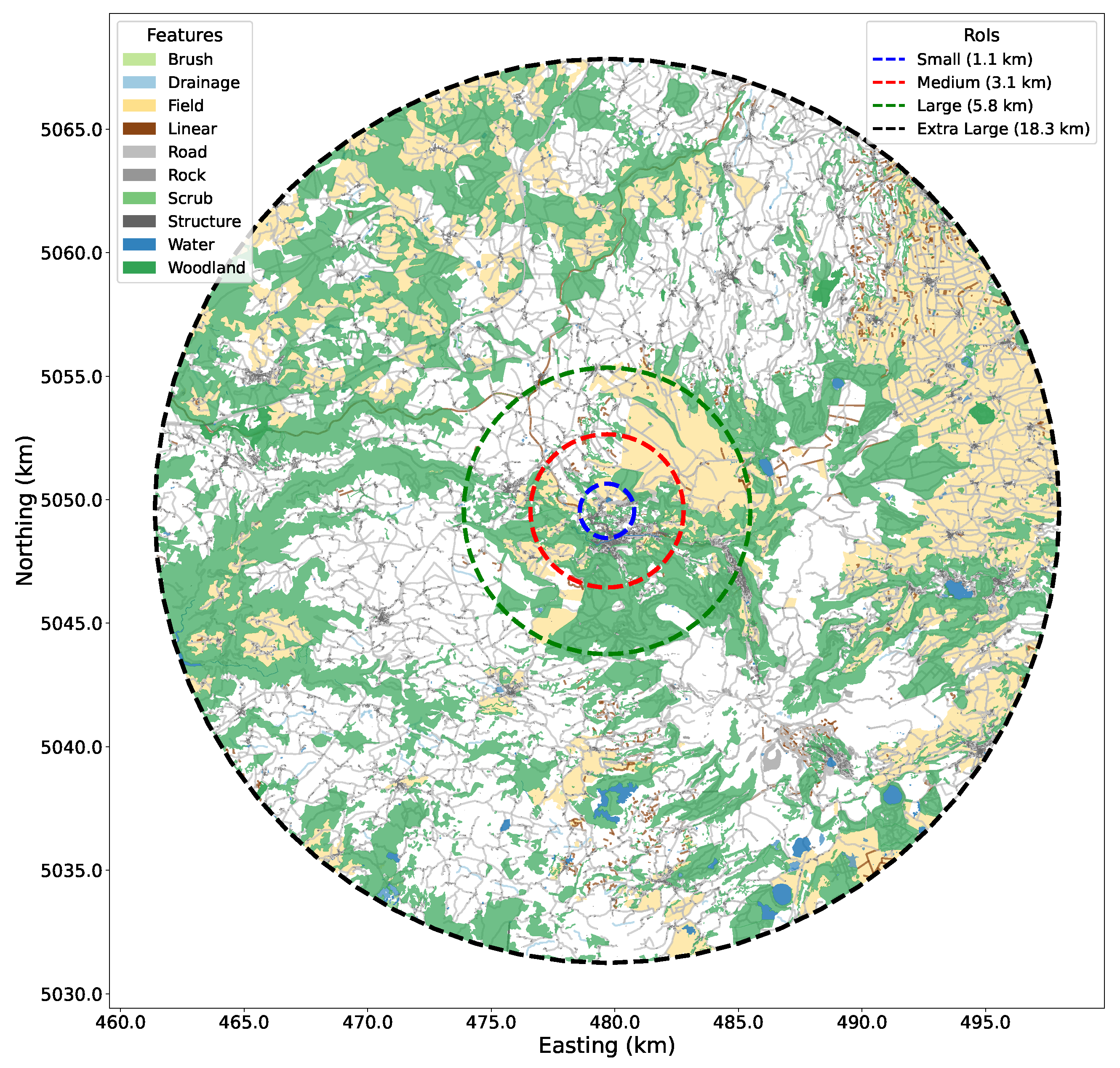
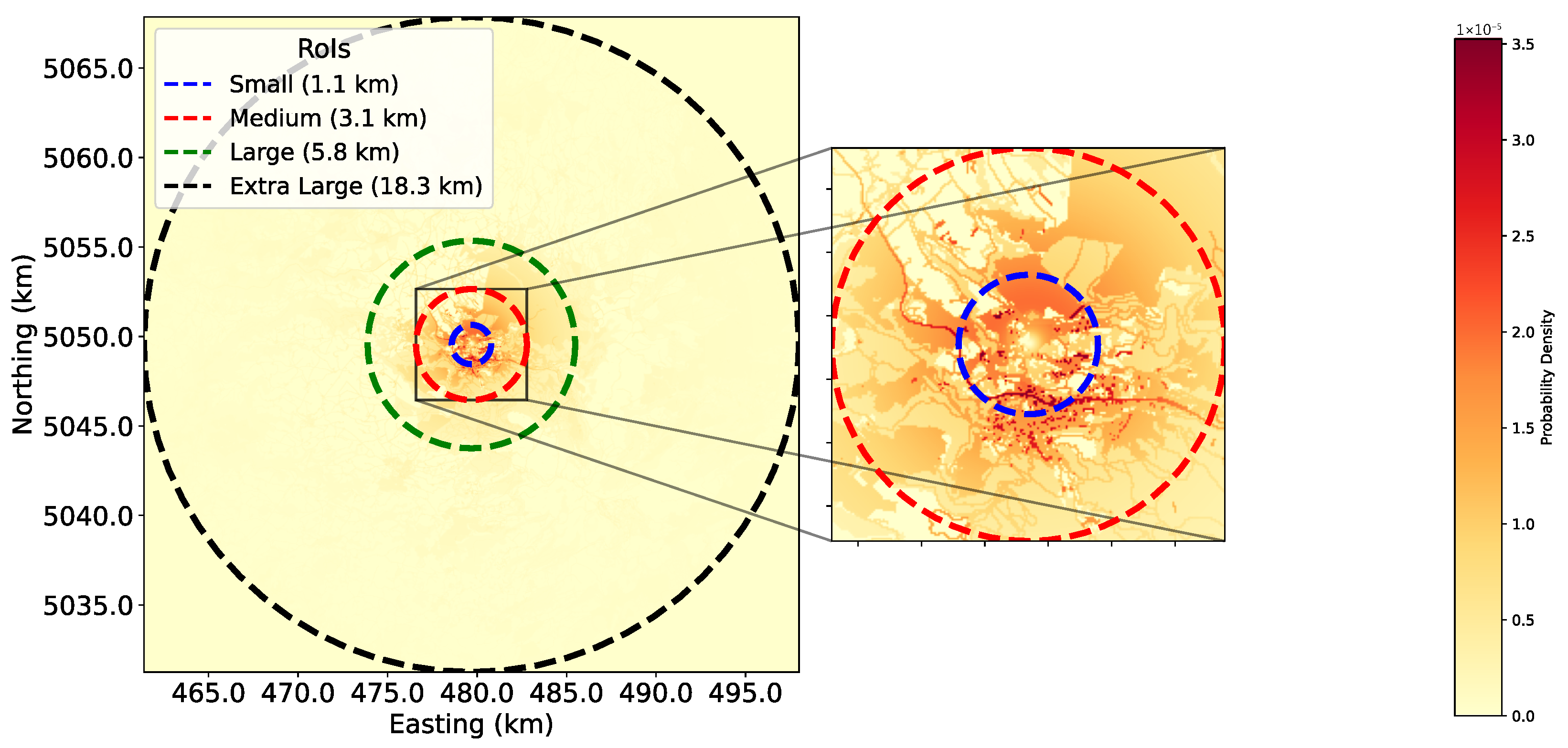
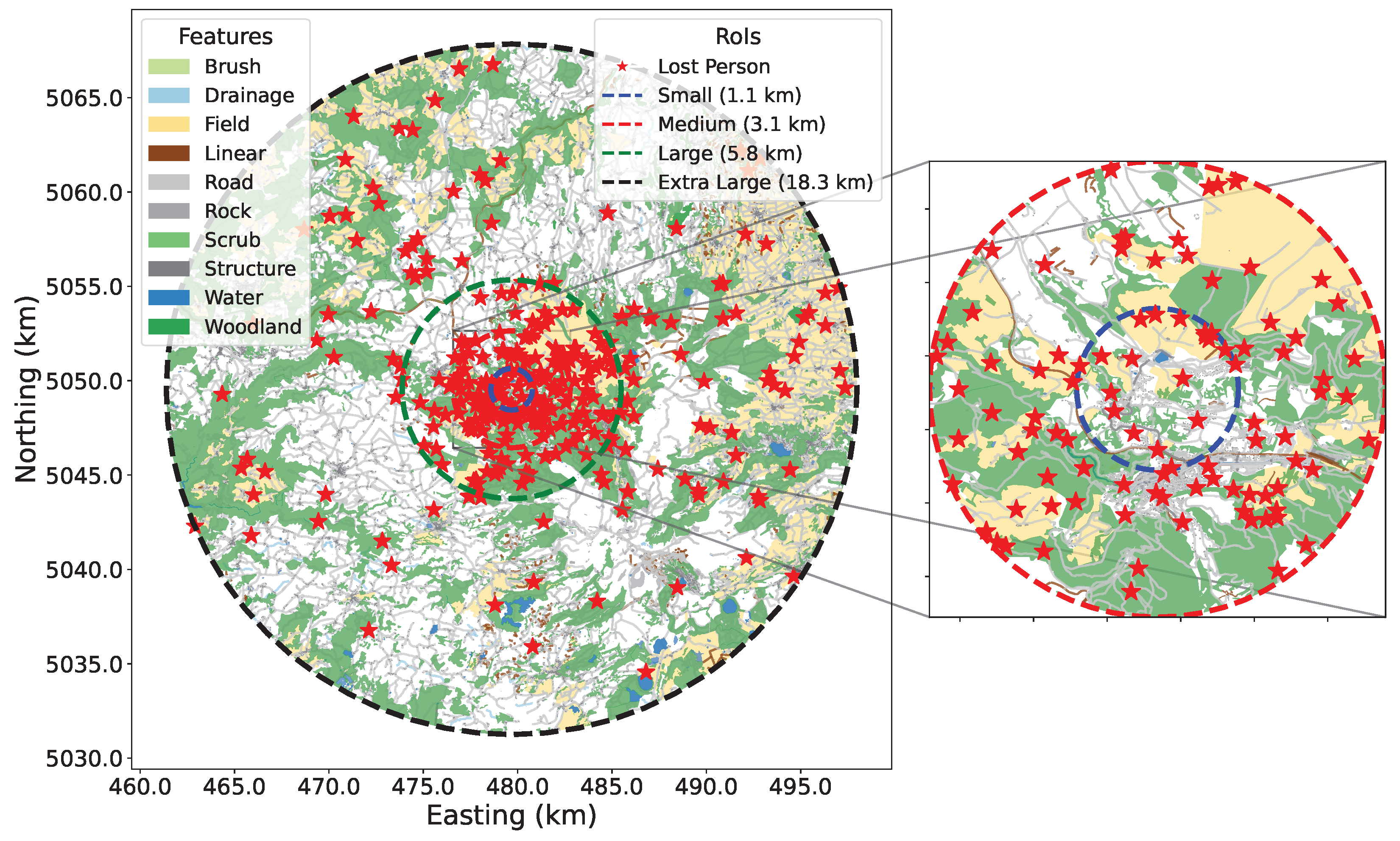
SAREnv: An Open-Source Dataset and Benchmark Tool for Informed Wilderness Search and Rescue Using UAVs
Abstract
Highlights
- We introduce SAREnv, a novel, open-source benchmark for wilderness search and rescue (SAR), which includes a dataset of 60 high-resolution geospatial scenarios and probabilistic lost person models derived from empirical data.
- A comprehensive evaluation framework is provided with four baseline multi-agent path-planning algorithms, three quantitative performance metrics, and tools that enable users to generate custom synthetic SAR datasets.
- This work addresses a deficiency in SAR research by providing a standardized framework for the systematic and reproducible comparison of UAV search strategies.
- The open-source nature of this benchmark is intended to accelerate innovation by enabling researchers to rigorously validate novel algorithms against established baselines, facilitating the development of more effective autonomous systems for real-world operations.
Abstract
1. Introduction
| Listing 1. A simple search path evaluation code example to evaluate the predefined baselines. |
|
evaluator = ComparativeEvaluator( dataset_directory=data_dir, evaluation_sizes=["large"], num_drones=10, num_lost_persons=100, ) results = evaluator.run_baseline_evaluations() evaluator.plot_results(results) |
Related Work
2. Materials and Methods
| Listing 2. Data-generation example code, which uses default feature types and probabilities. The code generates a dataset at a specific location, which is in a flat environment and a temperate climate. |
|
data_gen = DataGenerator() initial_planning_point = LON, LAT output_dir = "sarenv_dataset" data_gen.export_dataset( center_point=initial_planning_point, output_directory=output_dir, environment_climate=CLIMATE_TEMPERATE, environment_type=ENVIRONMENT_TYPE_FLAT, meter_per_bin=30, ) |
2.1. Feature Extraction and Environment Model
2.2. Probability Map Generation
2.3. Modeling Lost Person Locations
3. Results
3.1. Baseline Planning Algorithms
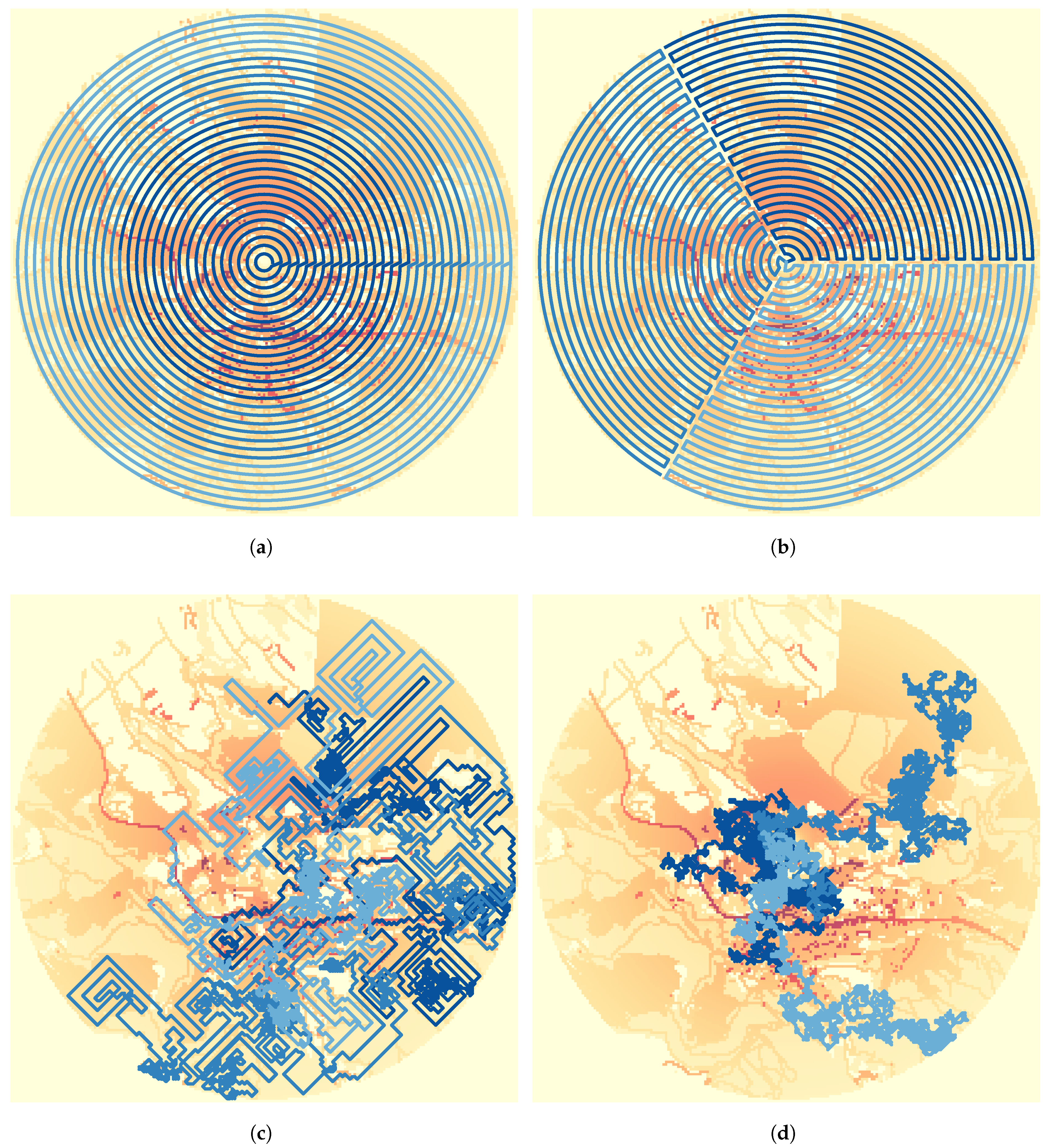
- Concentric Circles: A series of concentric circular paths is created and segmented equally among the available drones.
- Pizza Zigzag: The circular search area is divided into wedge-shaped “slices,” with each drone assigned to cover one slice using a zigzag pattern (boustrophedon).
- Greedy: A path generator following a greedy policy, prioritizing not revisiting cells, and performing random exploration if all neighboring spaces are visited.
- Random Exploration: Random exploration throughout the environment.
3.2. Accumulated Probability of Detection
3.3. Time-Discounted Probability of Detection
3.4. Lost Person Discovery Score
3.5. Benchmark Evaluations
| Listing 3. Instantiation of the ComparativeDatasetEvaluator for batch evaluation. This example demonstrates the evaluation of two path generation algorithms, a custom generator (CustomLine) and a predefined baseline (Greedy), across 60 datasets of varying sizes (“small,” “medium,” and “large”). The evaluate method executes the comparison and stores the resulting metrics. |
| custom_generators = { "CustomLine": create_custom_path_generator(), "Greedy": PathGenerator("Greedy", paths.generate_greedy_path), } evaluator_custom = ComparativeDatasetEvaluator( dataset_dirs=[f"sarenv_dataset/{i}" for i in range(1, 61)], budget=100_000, num_drones=args.num_drones, evaluation_sizes=["small", "medium", "large"], custom_generators=custom_generators, ) metrics_df, time_series_df = evaluator.evaluate(output_dir="results") |
4. Discussion
5. Conclusions
6. Future Work
Supplementary Materials
Author Contributions
Funding
Data Availability Statement
Conflicts of Interest
References
- Queralta, J.P.; Taipalmaa, J.; Pullinen, B.C.; Sarker, V.K.; Gia, T.N.; Tenhunen, H.; Gabbouj, M.; Raitoharju, J.; Westerlund, T. Collaborative Multi-Robot Search and Rescue: Planning, Coordination, Perception, and Active Vision. IEEE Access 2020, 8, 191617–191643. [Google Scholar] [CrossRef]
- Hoang, M.T.; van Berkel, N.; Grøntved, K.A.R.; Skov, M.; Christensen, A.L.; Merritt, T. Drone Swarms to Support Search and Rescue Operations: Opportunities and Challenges. In Cultural Robotics: Social Robots and their Emergent Cultural Ecologies; Springer: Cham, Switzerland, 2023; pp. 163–176. [Google Scholar]
- Grøntved, K.; Bahodi, M.T.; Christensen, A.L. Automated Task Generation for Multi-Drone Search and Rescue Operations. In Proceedings of the Distributed Computing and Artificial Intelligence, 21st International Conference, Salamanca, Spain, 25–27 June 2024; Springer: Cham, Switzerland, 2024; pp. 266–271. [Google Scholar]
- Lin, L.; Goodrich, M.A. A Bayesian approach to modeling lost person behaviors based on terrain features in Wilderness Search and Rescue. Comput. Math. Organ. Theory 2010, 16, 300–323. [Google Scholar] [CrossRef]
- Koester, R.J. Lost Person Behavior: A Search and Rescue Guide on Where to Look for Land, Air, and Water; dbS Productions: Charlottesville, VA, USA, 2008. [Google Scholar]
- Drew, D.S. Multi-Agent Systems for Search and Rescue Applications. Curr. Robot. Rep. 2021, 2, 189–200. [Google Scholar] [CrossRef]
- Choset, H.; Pignon, P. Coverage Path Planning: The Boustrophedon Decomposition. In Proceedings of the International Conference on Field and Service Robotics, Espoo, Finland, 11–13 June 2001; Finish Society of Automation: Helsinki, Finland, 2001; pp. 203–209. [Google Scholar]
- Ge, Z.; Jiang, J.; Coombes, M. Multi-Uav Search and Rescue in Wilderness Using Smart Agent-Based Probability Models. arXiv 2024, arXiv:2411.10148. [Google Scholar] [CrossRef]
- Fan, X.; Li, H.; Chen, Y.; Dong, D. UAV Swarm Search Path Planning Method Based on Probability of Containment. Drones 2024, 8, 132. [Google Scholar] [CrossRef]
- Waharte, S.; Trigoni, N. Supporting Search and Rescue Operations with UAVs. In Proceedings of the 2010 International Conference on Emerging Security Technologies, EST 2010, Canterbury, UK, 6–7 September 2010; Howells, G., Sirlantzis, K., Stoica, A., Huntsberger, T., Arslan, T., Eds.; IEEE Computer Society: Los Alamitos, CA, USA, 2010; pp. 142–147. [Google Scholar] [CrossRef]
- Miller, L.M.; Silverman, Y.; MacIver, M.A.; Murphey, T.D. Ergodic Exploration of Distributed Information. IEEE Trans. Robot. 2016, 32, 36–52. [Google Scholar] [CrossRef]
- Ivic, S.; Andrejcuk, A.; Druzeta, S. Autonomous Control for Multi-Agent Non-Uniform Spraying. Appl. Soft Comput. 2019, 80, 742–760. [Google Scholar] [CrossRef]
- McCammon, S.; Hollinger, G.A. Topological Path Planning for Autonomous Information Gathering. Auton. Robot. 2021, 45, 821–842. [Google Scholar] [CrossRef]
- Moon, B.G.; Chatterjee, S.; Scherer, S.A. TIGRIS: An Informed Sampling-Based Algorithm for Informative Path Planning. In Proceedings of the IEEE/RSJ International Conference on Intelligent Robots and Systems, IROS 2022, Kyoto, Japan, 23–27 October 2022; pp. 5760–5766. [Google Scholar] [CrossRef]
- Balta, H.; Muscato, G.; Orlando, G. Integrated Data Management for a Fleet of Search-and-Rescue Robots. J. Field Robot. 2016, 33, 489–508. [Google Scholar] [CrossRef]
- Krizhevsky, A. Learning Multiple Layers of Features From Tiny Images; Technical Report; University of Toronto: Toronto, ON, Canada, 2009. [Google Scholar]
- Deng, J.; Dong, W.; Socher, R.; Li, L.; Li, K.; Li, F.-F. ImageNet: A Large-Scale Hierarchical Image Database. In Proceedings of the 2009 IEEE Computer Society Conference on Computer Vision and Pattern Recognition (CVPR 2009), Miami, FL, USA, 20–25 June 2009; IEEE Computer Society: Los Alamitos, CA, USA, 2009; pp. 248–255. [Google Scholar] [CrossRef]
- Varga, L.A.; Kiefer, B.; Messmer, M.; Zell, A. SeaDronesSee: A Maritime Benchmark for Detecting Humans in Open Water. In Proceedings of the 2022 IEEE/CVF Winter Conference on Applications of Computer Vision (WACV), Waikoloa, HI, USA, 3–8 January 2022; IEEE Computer Society: Los Alamitos, CA, USA, 2022; pp. 3686–3696. [Google Scholar] [CrossRef]
- Broyles, D.; Hayner, C.R.; Leung, K. WiSARD: A Labeled Visual and Thermal Image Dataset for Wilderness Search and Rescue. In Proceedings of the IEEE/RSJ International Conference on Intelligent Robots and Systems, IROS 2022, Kyoto, Japan, 23–27 October 2022; pp. 9467–9474. [Google Scholar] [CrossRef]
- Grøntved, K.A.R.; Jarabo-Peñas, A.; Reid, S.; Rolland, E.G.A.; Christensen, A.L. SAREnv: UAV Search and Rescue Dataset and Evaluation Framework. 2025. Available online: https://github.com/namurproject/SAREnv (accessed on 1 September 2025).
- Galceran, E.; Carreras, M. A Survey on Coverage Path Planning for Robotics. Robot. Auton. Syst. 2013, 61, 1258–1276. [Google Scholar] [CrossRef]
- Vazquez-Carmona, E.V.; Vasquez-Gomez, J.I.; Herrera-Lozada, J.C.; Antonio-Cruz, M. Coverage Path Planning for Spraying Drones. Comput. Ind. Eng. 2022, 168, 108125. [Google Scholar] [CrossRef]
- Torres, M.; Pelta, D.A.; Verdegay, J.L.; Torres, J.C. Coverage Path Planning With Unmanned Aerial Vehicles for 3D Terrain Reconstruction. Expert Syst. Appl. 2016, 55, 441–451. [Google Scholar] [CrossRef]
- Foo, G. Emergency Response and Search & Rescue: An Operational Book; Dimersar: Mississauga, ON, Canada, 2012. [Google Scholar]
- Hart, S. UAV Operator Decision-Making in a Search and Rescue Application. Master’s Thesis, University of Bristol, Bristol, UK, 2023. [Google Scholar]
- Bähnemann, R.; Lawrance, N.R.J.; Chung, J.J.; Pantic, M.; Siegwart, R.; Nieto, J.I. Revisiting Boustrophedon Coverage Path Planning as a Generalized Traveling Salesman Problem. In Proceedings of the Field and Service Robotics—Results of the 12th International Conference, FSR 2019, Tokyo, Japan, 29–31 August 2019; Ishigami, G., Yoshida, K., Eds.; Springer Proceedings in Advanced Robotics. Springer: Berlin/Heidelberg, Germany, 2019; Volume 16, pp. 277–290. [Google Scholar] [CrossRef]
- Choset, H. Coverage for Robotics—A Survey of Recent Results. Ann. Math. Artif. Intell. 2001, 31, 113–126. [Google Scholar] [CrossRef]
- Nielsen, L.D.; Sung, I.; Nielsen, P. Convex Decomposition for a Coverage Path Planning for Autonomous Vehicles: Interior Extension of Edges. Sensors 2019, 19, 4165. [Google Scholar] [CrossRef] [PubMed]
- Dong, W.; Liu, S.; Ding, Y.; Sheng, X.; Zhu, X. An Artificially Weighted Spanning Tree Coverage Algorithm for Decentralized Flying Robots. IEEE Trans. Autom. Sci. Eng. 2020, 17, 1689–1698. [Google Scholar] [CrossRef]
- Ha, I.; Cho, Y. A Probabilistic Target Search Algorithm Based on Hierarchical Collaboration for Improving Rapidity of Drones. Sensors 2018, 18, 2535. [Google Scholar] [CrossRef]
- Rosselló, N.B.; Carpio, R.F.; Gasparri, A.; Garone, E. Information-Driven Path Planning for UAV With Limited Autonomy in Large-Scale Field Monitoring. IEEE Trans. Autom. Sci. Eng. 2022, 19, 2450–2460. [Google Scholar] [CrossRef]
- Bai, S.; Shan, T.; Chen, F.; Liu, L.; Englot, B. Information-Driven Path Planning. Curr. Robot. Rep. 2021, 2, 177–188. [Google Scholar] [CrossRef]
- Lin, L.; Goodrich, M.A. UAV Intelligent Path Planning for Wilderness Search and Rescue. In Proceedings of the 2009 IEEE/RSJ International Conference on Intelligent Robots and Systems, St. Louis, MO, USA, 11–15 October 2009; pp. 709–714. [Google Scholar] [CrossRef]
- Vasquez-Gomez, J.I.; Herrera-Lozada, J.C.; Olguin-Carbajal, M. Coverage Path Planning for Surveying Disjoint Areas. In Proceedings of the 2018 International Conference on Unmanned Aircraft Systems (ICUAS), Dallas, TX, USA, 12–15 June 2018; pp. 899–904. [Google Scholar]
- Zhao, Z.; Shen, H.; Liang, X.; Wang, L.; Han, B. Construction of a Virtual Dataset of Maritime Search and Rescue Targets for Unmanned Aerial Vehicles. Ocean Eng. 2025, 328, 120926. [Google Scholar] [CrossRef]
- Sy Nguyen, V.; Jung, J.; Jung, S.; Joe, S.; Kim, B. Deployable Hook Retrieval System for UAV Rescue and Delivery. IEEE Access 2021, 9, 74632–74645. [Google Scholar] [CrossRef]
- OpenStreetMap Contributors. Planet Dump. 2017. Available online: https://planet.osm.org (accessed on 1 September 2025).
- Doherty, P.J.; Guo, Q.; Doke, J.; Ferguson, D. An Analysis of Probability of Area Techniques for Missing Persons in Yosemite National Park. Appl. Geogr. 2014, 47, 99–110. [Google Scholar] [CrossRef]
- Tan, C.S.; Mohd-Mokhtar, R.; Arshad, M.R. A Comprehensive Review of Coverage Path Planning in Robotics Using Classical and Heuristic Algorithms. IEEE Access 2021, 9, 119310–119342. [Google Scholar] [CrossRef]
- Li, Q.; Ramezani, R.; Hwangbo, M.; Bellingham, J.G. Path Planning with Probabilistic Target Detection and Localization. In Proceedings of the AIAA Scitech 2020 Forum, Orlando, FL, USA, 6–10 January 2020; American Institute of Aeronautics and Astronautics: Reston, VA, USA, 2020. [Google Scholar]
- Kohlbrecher, S.; Stumpf, A.; Meyer, J.; Klingauf, U. Rescue Robot Capabilities for Victim Localization and Characterization in the Robocup Rescue League. In RoboCup 2014: Robot World Cup XVIII; Springer: Berlin/Heidelberg, Germany, 2015; pp. 106–117. [Google Scholar] [CrossRef]
- Trojanowski, K.; Mikitiuk, A.; Grzeszczak, J.; Guinand, F. Complete Coverage and Path Planning for a Team of UAVs in a Realistic Urban Environment Using Evolutionary Algorithms. In Applications of Evolutionary Computation; Springer: Berlin/Heidelberg, Germany, 2024. [Google Scholar] [CrossRef]
- Carpin, S.; Lewis, M.; Wang, J.; Balakirsky, S.; Scrapper, C. Bridging the Gap Between Simulation and Reality in Urban Search and Rescue. In Proceedings of the RoboCup 2006: Robot Soccer World Cup X; Springer: Berlin/Heidelberg, Germany, 2007; pp. 1–12. [Google Scholar]
- Jain, V.; Jena, R.; Li, H.; Gupta, T.; Hughes, D.; Lewis, M.; Sycara, K. Predicting human strategies in simulated search and rescue task. Accepted at NeurIPS 2020. In Proceedings of the Workshop on Artificial Intelligence for Humanitarian Assistance and Disaster Response (AI+ HADR 2020), Virtual Event, 12 December 2020. [Google Scholar] [CrossRef]
- Heintzman, L.; Hashimoto, A.; Abaid, N.; Williams, R.K. Anticipatory Planning and Dynamic Lost Person Models for Human-Robot Search and Rescue. In Proceedings of the 2021 IEEE International Conference on Robotics and Automation (ICRA), Xi’an, China, 30 May–5 June 2021; pp. 8252–8258. [Google Scholar] [CrossRef]


| Find Location (%) | Temperate | Dry |
|---|---|---|
| n | 312 | 196 |
| Structure | 13% | 10% |
| Road | 13% | 17% |
| Linear | 25% | 31% |
| Drainage | 12% | 18% |
| Water | 8% | 9% |
| Brush | 2% | 2% |
| Scrub | 3% | 3% |
| Woods | 7% | 6% |
| Field | 14% | 1% |
| Rock | 4% | 2% |
| Horizontal Distance from the IPP * | Temperate | Dry | ||
|---|---|---|---|---|
| Mountains | Flat | Mountains | Flat | |
| n | 568 | 274 | 221 | 58 |
| Small | 1.1 (3.8) | 0.6 (1.1) | 1.6 (8.0) | 1.3 (5.3) |
| Medium | 3.1 (30.2) | 1.8 (10.2) | 3.2 (32.2) | 2.1 (13.8) |
| Large | 5.8 (105.7) | 3.2 (32.2) | 6.5 (132.7) | 6.6 (136.8) |
| Extra large | 18.3 (1052.1) | 9.9 (307.9) | 19.3 (1170.2) | 13.1 (539.1) |
Disclaimer/Publisher’s Note: The statements, opinions and data contained in all publications are solely those of the individual author(s) and contributor(s) and not of MDPI and/or the editor(s). MDPI and/or the editor(s) disclaim responsibility for any injury to people or property resulting from any ideas, methods, instructions or products referred to in the content. |
© 2025 by the authors. Licensee MDPI, Basel, Switzerland. This article is an open access article distributed under the terms and conditions of the Creative Commons Attribution (CC BY) license (https://creativecommons.org/licenses/by/4.0/).
Share and Cite
Grøntved, K.A.R.; Jarabo-Peñas, A.; Reid, S.; Rolland, E.G.A.; Watson, M.; Richards, A.; Bullock, S.; Christensen, A.L. SAREnv: An Open-Source Dataset and Benchmark Tool for Informed Wilderness Search and Rescue Using UAVs. Drones 2025, 9, 628. https://doi.org/10.3390/drones9090628
Grøntved KAR, Jarabo-Peñas A, Reid S, Rolland EGA, Watson M, Richards A, Bullock S, Christensen AL. SAREnv: An Open-Source Dataset and Benchmark Tool for Informed Wilderness Search and Rescue Using UAVs. Drones. 2025; 9(9):628. https://doi.org/10.3390/drones9090628
Chicago/Turabian StyleGrøntved, Kasper Andreas Rømer, Alejandro Jarabo-Peñas, Sid Reid, Edouard George Alain Rolland, Matthew Watson, Arthur Richards, Steve Bullock, and Anders Lyhne Christensen. 2025. "SAREnv: An Open-Source Dataset and Benchmark Tool for Informed Wilderness Search and Rescue Using UAVs" Drones 9, no. 9: 628. https://doi.org/10.3390/drones9090628
APA StyleGrøntved, K. A. R., Jarabo-Peñas, A., Reid, S., Rolland, E. G. A., Watson, M., Richards, A., Bullock, S., & Christensen, A. L. (2025). SAREnv: An Open-Source Dataset and Benchmark Tool for Informed Wilderness Search and Rescue Using UAVs. Drones, 9(9), 628. https://doi.org/10.3390/drones9090628


