Article

Modeling and Simulation of Urban Laser Countermeasures Against Low-Slow-Small UAVs

1
Institute of Applied Electronics, China Academy of Engineering Physics, Mianyang 621900, China
2
Graduate School of China Academy of Engineering Physics, Beijing 100088, China
*
Author to whom correspondence should be addressed.
Drones 2025, 9(6), 419; https://doi.org/10.3390/drones9060419
Submission received: 29 April 2025 / Revised: 30 May 2025 / Accepted: 4 June 2025 / Published: 8 June 2025
(This article belongs to the Collection Drones for Security and Defense Applications)

Abstract

:
This study addresses the modeling and simulation challenges of urban laser countermeasure systems against Low-Slow-Small (LSS) UAVs by proposing a physics simulation framework integrating Geographic Information System (GIS)-based dynamic 3D real-world scenes and constructing a hybrid Anti-UAV dataset combining real and simulated data. A three-stage target tracking system is developed, encompassing target acquisition, coarse tracking, and precise tracking. Furthermore, the UAV-D-Fine detection algorithm is introduced, significantly improving small-target detection accuracy and efficiency. The simulation platform achieves dynamic fusion between target models and GIS real-scene models, enabling a full physical simulation of UAV takeoff, tracking, aiming, and laser engagement, with additional validation of laser antenna tracking performance. Experimental results demonstrate the superior performance of the proposed algorithm in both simulated and real-world environments, ensuring accurate UAV detection and sustained tracking, thereby providing robust support for low-altitude UAV laser countermeasure missions.

1. Introduction

Low-Slow-Small (LSS) unmanned aerial vehicles (UAVs) pose significant threats to modern urban security and military defense due to their small size, high maneuverability, and stealth characteristics [1]. Traditional countermeasures, such as radar detection [2] and electromagnetic interference [3], face challenges in urban environments, including limited accuracy and high collateral damage risks. Recently, laser-based directed energy countermeasures [4] have attracted attention for their precision, rapid response, and minimal collateral damage.
The laser antenna Acquisition, Tracking, and Pointing (ATP) system [5], a core component of laser countermeasures, must achieve rapid target acquisition, dynamic tracking, and precise aiming. Its performance is crucial to effective interception. However, laser interception of LSS targets depends not only on detection and acquisition but also on accurate target identification, stable tracking, and precise aiming, especially in complex urban settings.
Challenges include dynamic lighting changes, background clutter, laser-induced flare/backscatter effects, and atmospheric attenuation from suspended particulates, all of which complicate feature extraction and tracking stability, presenting key technical hurdles. Figure 1 presents drone target samples collected under actual complex urban backgrounds, forest backgrounds, and strong turbulence environments.
Laser countermeasure modeling and simulation for Low-Slow-Small (LSS) UAVs face four major challenges:
  • Target Recognition and Tracking in Complex Environments: Low-altitude small targets have low brightness and contrast, often impacted by strong sunlight backgrounds and motion blur. These factors make it difficult for traditional feature extraction algorithms to distinguish targets from the background [6]. Multi-frame saliency detection methods struggle in dynamic urban environments.
  • Laser Transmission and Atmospheric Disturbance Effects: Atmospheric turbulence [7] and the absorption and scattering of laser energy by suspended particulates reduce target backscatter intensity, distort the laser spot, and ultimately degrade tracking accuracy and damage effectiveness.
  • Robust Control for High-Speed Maneuvering Targets: The high maneuverability of UAVs requires ATP systems with faster dynamic response and greater resistance to interference. Traditional PID control algorithms lack sufficient stability in complex disturbance environments.
  • Multi-Physics Coupled Simulation Challenges: There is a lack of an integrated simulation framework for laser transmission, optical system dynamics, control algorithms, and atmospheric effects, limiting efficient multi-disciplinary simulations.
Based on advancements in laser ATP systems, this study proposes a comprehensive modeling and simulation framework that addresses the kinematics of LSS targets and the complexities of environmental interference. Key innovations include UAV-D-Fine, a Transformer-based detection algorithm [8] designed to enhance small UAV recognition in dynamic environments, and a Multi-Physics Coupled Simulation Platform that enables integrated analysis of laser interaction, optical system dynamics, and environmental disturbances, providing both theoretical and technical support for optimizing LSS UAV countermeasure systems.

2. Related Work

2.1. Applications in UAV Simulation and Autonomous Control

The AirSim(v1.8.1) platform [9], developed by Microsoft Research, is an open-source high-fidelity physics engine that provides standardized environments for UAV dynamics modeling and sensor simulation. With its realistic scene rendering based on Unreal Engine(v5.1) and multi-physics coupling, AirSim significantly reduces the cost of real-world flight testing. For example, Madaan et al. [10] extended AirSim to create the Drone Racing Lab framework, supporting multi-environment track generation, head-to-head racing modes, and co-simulation of multi-modal sensors (monocular, depth, optical flow, and neuromorphic event cameras). This framework’s modular APIs offer an end-to-end validation platform for state estimation, trajectory planning, and obstacle avoidance in drone racing, with reinforcement and imitation learning capabilities demonstrated in the NeurIPS 2019 competition.
Chao et al. [11] introduced the event-driven Deep Q-Network (E-DQN), which integrates event stream data and autoencoder feature extraction, improving path planning efficiency by 19% compared to traditional DQN in Unreal Engine-based obstacle simulations. Shang-En Shen et al. [12] trained UAVs for autonomous flight in AirSim/Unreal Engine environments using deep reinforcement learning algorithms (DQN, A2C, PPO), achieving a 71% target traversal rate with PPO and continuous reward shaping. While current research focuses mainly on navigation and obstacle avoidance, dynamic countermeasure simulations for laser defense systems remain underexplored.

2.2. Simulation-Based Target Detection and Reinforcement Learning

AirSim’s multi-modal sensor interfaces (RGB, infrared, and depth cameras) provide extensive data for dynamic target detection. Shimada et al. [13] achieved dynamic obstacle distance perception during high-speed UAV flights by fusing monocular depth estimation with optical flow. Their depth maps exceed physical sensor limitations, offering precise environmental data for path planning.
Mittal et al. [14] built a quadrotor UAV simulation model in MATLAB/Simulink, generating annotated datasets with pedestrians, obstacles, and other targets. While YOLOv3 demonstrated good generalization on this synthetic data, Simulink’s environmental realism and physical interaction accuracy are notably inferior to AirSim.
Chen et al. [15] used AirSim to generate high-fidelity UAV simulation data and developed a small-target detection framework based on transfer learning and adaptive feature fusion. This method improved YOLOv5 detection accuracy by 7.1% through simulation-to-real domain adaptation (pretraining and fine-tuning) and multi-scale feature fusion, enhancing edge and texture representation.
These advancements demonstrate AirSim’s scalability for complex decision-making tasks, though they do not consider the closed-loop interaction between ATP systems and target motion in laser countermeasure applications.

2.3. Vision-Based Anti-UAV Detection in Real-World Scenarios

Wang et al. [16] reviewed vision-based anti-UAV detection and tracking technologies, noting the simultaneous advancement of algorithm innovation, sensor fusion, and dataset iteration. They identified YOLO algorithms [17,18] as the dominant framework for real-time performance, with several improvements in low-altitude target detection. For instance, Hu et al. [19] enhanced YOLOv3 with an attention-based feature fusion module, resulting in a 12.5% increase in recall for small UAVs, while Cheng et al. [20] proposed a local-global feature focusing network that reduced false detection rates to 1.3% through dynamic feature weighting. Despite these advancements, challenges remain, particularly under complex lighting conditions, occlusion, and rapid motion. Li et al. [21] developed an infrared tracking framework with motion compensation, but tracking success dropped by 37% under slow cloud interference.

2.4. Comparative Analysis of Laser Countermeasure Simulation Frameworks

The effects of atmospheric conditions on laser transmission are typically modeled using Monte Carlo simulations [22] or empirical models such as MODTRAN [23]. These models account for factors like urban aerosols and humidity gradients, which cause laser beam divergence and energy attenuation, reducing effectiveness. Additionally, the interaction between laser energy and target materials, such as nonlinear ablation in carbon fiber composites, requires advanced multi-physics simulations (e.g., COMSOL (v6.2) [24], ANSYS (v2025 R1) [25]) to optimize laser parameters. While traditional tools like MATLAB/Simulink (v2025) and Zemax [26] are commonly used for laser countermeasure simulations, they suffer from low environmental realism and inadequate multi-physics coupling. AirSim, on the other hand, provides a high-fidelity physics engine and open APIs that facilitate closed-loop validation of laser transmission, target maneuvering, and control logic, offering a more comprehensive platform for these simulations.

2.5. Research Gaps and Novel Contributions

While AirSim has been applied in UAV navigation and target detection, it has not been utilized for dynamic laser countermeasure simulations in LSS UAV scenarios. This work introduces significant innovations, including the integration of dynamic skylight backgrounds, aerosol scattering, and laser retro-reflection effects in AirSim to simulate the complex interactions between lasers, targets, and the atmosphere in urban environments. Additionally, this study implements a hardware-in-the-loop (HIL) simulation framework that enables end-to-end validation from target detection (using UAV-D-Fine) to laser engagement, all through AirSim’s Python(v3.11) API. The results demonstrate that this approach significantly shortens system-level validation cycles compared to traditional segmented simulations, providing high-confidence data to optimize control parameters under complex environmental conditions.
Despite significant progress in UAV simulation, target detection, and laser countermeasure simulations, existing platforms and models still face limitations in comprehensively simulating the interactions between lasers, targets, and complex environments. Current tools often lack closed-loop interactions and multi-physics coupling necessary for realistic laser countermeasure scenarios. To address these challenges, this study proposes an integrated simulation framework that combines dynamic 3D real-world scenes and hybrid datasets to enhance the accuracy and efficiency of laser countermeasures against LSS UAVs. The following section details the development of this framework.

3. Laser Countermeasure Simulation Framework Based on Multimodal Collaboration

Addressing the multiphysics coupling and dynamic engagement requirements of laser countermeasure systems against LSS UAVs, this study proposes the simulation framework illustrated in Figure 2. Its core comprises a four-layer architecture: “Interactive Feedback”, “Dynamic Fusion”, “Multi-Model Collaboration”, and “Data-Driven Operation”.
The framework leverages AirSim’s high-fidelity physics engine and implements Hardware-in-the-Loop (HIL) control via Python APIs, establishing a closed-loop verification environment integrating laser transmission, target motion, and environmental disturbances. Compared to conventional segmented simulation tools, the innovations of this architecture are manifested in the following:
  • Real-Time Interaction in Dynamic Engagement Scenarios: Supports multi-perspective collaborative control and data-driven target tracking, simulating the adversarial process between UAV evasive maneuvers and dynamic laser beam tuning.
  • Multi-Source Heterogeneous Data Fusion: Integrates GIS terrain data, BIM building models, and real-time meteorological information to generate three-dimensional dynamic scenarios in urban canyon environments.

3.1. Construction of 3D GIS Panorama Model Library

To address the multiphysics co-simulation challenges outlined in the Introduction, this study integrates oblique photogrammetry with the Cesium geospatial engine [27] to construct a high-precision 3D GIS model library, providing a spatial reference for multi-environment coupled simulations of laser countermeasure systems. The workflow includes the following:
  • Lightweighting and LOD Optimization of Oblique Photogrammetric Models: To improve rendering efficiency in complex urban environments, a mesh simplification algorithm based on vertex clustering and edge collapse [1] is used, reducing the number of original triangles by more than 70% (Equation (1)):
    M = arg min M M v M v μ ( v ) 2
    where μ ( v ) represents the centroid of the vertex cluster. The LOD hierarchy is then constructed based on the viewpoint distance d and screen-space error (SSE) (Equation (2)):
    SSE = ϵ · d f · tan ( θ / 2 )
    where ϵ is the geometric error threshold, f is the focal length, and θ is the field of view angle.
  • Geospatial Registration and Coordinate Transformation: To address the discrepancy between the local coordinate system and the global geodetic reference frame, a seven-parameter coordinate transformation model constrained by Ground Control Points (GCPs) is employed (Equation (3)):
    X Y Z WGS 84 = Δ X Δ Y Δ Z + ( 1 + λ ) cos φ sin φ 0 sin φ cos φ 0 0 0 1 x y z local
    The parameters ( Δ X , Δ Y , Δ Z , λ , φ ) are optimized using the Levenberg–Marquardt algorithm to achieve sub-meter positioning accuracy (Figure 3c).
  • Dynamic Tile-Based Loading Mechanism: Based on the 3D Tiles specification, a spatial quadtree index is used to partition large-scale models (Equation (4)):
    T ( l , x , y ) = x 2 l max l , y 2 l max l
    where l denotes the tile level and l max the maximum level. By applying view frustum culling and occlusion culling algorithms [28], the rendering frame rate is boosted to over 60 FPS (Figure 3a,b).

3.2. Dynamic Fusion Modeling of Targets and Environments

To address the challenges of complex background interference and dynamic environmental coupling, this study proposes a multimodal data fusion framework that enables physical interaction between UAV motion and the GIS-based geospatial environment. The framework includes the following:
  • Illumination Consistency Modeling: To simulate the skylight background interference described in the Introduction, a real-time illumination model based on atmospheric scattering is developed (Equation (5)) [29]:
    L ( p ) = L 0 e β e R + σ s β e L sun ( 1 e β e R )
    where β e = β a + β s is the total extinction coefficient, R s the optical path length, and σ s is the scattering phase function.
  • Terrain Dynamics Coupling: To model the aerodynamic interference force on the UAV, we introduce a Digital Surface Model (DSM) and fluid dynamics coupling method, calculating the aerodynamic interference force (Equation (6)):
    F aero = 1 2 ρ C D A v wind v UAV 2 · n flow
    where ρ is the air density, C D is the drag coefficient, and n flow is the local wind direction unit vector.
  • Environmental Disturbances Across Multiple Time Scales: The impact of atmospheric turbulence on laser propagation is modeled using a stochastic differential equation (SDE) (Equation (7)):
    d I ( t ) = γ I ( t ) d t + σ I ( t ) d W t
    where γ is the attenuation coefficient, σ is the turbulence intensity parameter, and W t is the Wiener process.

3.3. Multi-Level Collaborative Tracking Control Architecture

To address the accuracy-real-time trade-off in dynamic target tracking outlined in the Introduction, this paper proposes a three-tier collaborative tracking architecture comprising Search-TV (STV), Coarse-TV (CTV), and Precise-TV (PTV) systems. The hierarchical control strategy enables closed-loop operation through the “Rapid Acquisition—Coarse Tracking—Precision Boresight Alignment” workflow, mathematically described as follows:
Pixel angle conversion model: The mapping from the image coordinate system to camera attitude angles is defined as follows:
Δ θ x = 2 · ( x c x d ) W · FOV h 2 , Δ θ y = 2 · ( y c y d ) H · FOV v 2
where ( x c , y c ) denotes the target center coordinates, ( x d , y d ) represents the image center, W × H is the image resolution, and FOV h , FOV v are the camera’s horizontal and vertical field-of-view angles.
  • Coarse-TV Tracking Control Law: The Coarse-TV (CTV) system uses a Proportional-Integral-Derivative (PID) controller for rapid response:
    u c ( t ) = K p c e ( t ) + K i c t 0 t e ( τ ) d τ + K d c d e ( t ) d t
    where the tracking error e ( t ) = [ Δ θ x , Δ θ y ] T , and the control parameters K p c = 0.015 , K i c = 0.002 , K d c = 0.001 are tuned via the frequency-domain response method. The quaternion update equation is formulated as follows:
    q c ( t + Δ t ) = q c ( t ) exp 1 2 0 u c , y u c , x
  • Precision-TV Fine-Tuning Strategy: The Precision-TV (PTV) system operates in parallel with the Coarse-TV (CTV) system, using a nonlinear PID compensation mechanism:
    u p ( t ) = K p p · sat ( e ( t ) ) + K i p e ( t ) d t + K d p d e ( t ) d t
    where sat ( · ) denotes the saturation function, with the parameters set as K p p = 0.005 , K i p = 0.0005 , K d p = 0.001 . The update equation for the camera attitude fine-tuning is as follows:
    q p ( t + Δ t ) = q p ( t ) I + Δ t 2 0 u p , z u p , y u p , z 0 u p , x u p , y u p , x 0
  • Kinematic Chain Transmission: The kinematic model of the camera platform is transmitted via the Lie group SE(3):
    T cam world = k = 1 3 exp [ ω k ] × v k 0 0 Δ t
    where ω k denotes the angular velocity twist and v k denotes the translational velocity twist.

4. Model Architecture

To address the detection challenges of LSS UAVs in complex backgrounds, this paper proposes an improved UAV-D-Fine model based on the D-FINE framework [30]. As illustrated in Figure 4, through optimizations in feature pyramid design, attention enhancement, and loss function refinement, the proposed model significantly improves small target detection accuracy and robustness.
The original D-FINE model employs a multi-scale feature fusion strategy, achieving high-precision target localization via iterative refinement of probability distributions (FDR) and a self-distillation mechanism (GO-LSD). However, for UAV small target detection tasks, the following structural improvements are implemented:
  • Lightweight Feature Pyramid Reconstruction: Traditional detection models (e.g., FPN) use multilevel feature layers (P2–P5) for the detection of multiscale targets. Deeper layers (P4, P5) are more sensitive to large targets, while shallower layers (P2, P3) retain finer details of small targets. This work removes the P4 and P5 detection layers, retaining only P2 (1/4 resolution) and P3 (1/8 resolution) as input to the detection head. The feature fusion process follows:
    F fused = Conv 1 × 1 ( F P 2 UpSample ( F P 3 ) )
    where ⊕ denotes element-wise addition, and UpSample refers to bilinear interpolation upsampling.
  • Dynamic Spatial Attention Mechanism (DSAM): To address image blurring and background confusion caused by high-speed UAV motion, the DSAM module is embedded in the D-Fine CCFM. This mechanism captures local context information along height and width directions to generate spatial attention weights.
    As shown in Figure 5: Given an input feature map: X R B × C × H × W , the DSAM computation follows: apply average pooling along the width and height directions for spatial attention:
    X h = AvgPool w ( X ) = 1 W w = 1 W X [ : , : , : , w ] R B × C × H × 1
    X w = AvgPool h ( X ) = 1 H h = 1 H X [ : , : , h , : ] R B × C × 1 × W
    Process X h and X w with grouped convolution and activation:
    A h = σ W h X h + b h R B × C × H × 1
    A w = σ W w X w + b w R B × C × 1 × W
    Channel attention generates descriptors through global average pooling on the input feature map:
    Z = GlobalAvgPool ( X ) = 1 H × W h = 1 H w = 1 W X [ : , : , h , w ] R B × C × 1 × 1
    Processed through two fully-connected layers (implemented as 1 × 1 convolutions) with nonlinear activation:
    A c = σ W 2 δ ( W 1 Z + b 1 ) + b 2 R B × C × 1 × 1
    where W 1 R C × C r × 1 × 1 , W 2 R C r × C × 1 × 1 are learnable parameters, and r is the channel compression ratio. δ denotes the ReLU activation function, and σ denotes the Sigmoid function.
    Weight fusion and output broadcast A h , A w to the original spatial dimensions for element-wise multiplication with A c and the input feature map:
    Output = X A h A w A c R B × C × H × W
    where ⊙ represents element-wise multiplication.
  • NWD Loss Function: To address the sensitivity of IoU to small target localization, the Normalized Wasserstein Distance (NWD) [2] is introduced as the regression loss. By modeling detection boxes as Gaussian distributions N ( μ , Σ ) , the NWD is defined as follows:
    NWD = exp W 2 2 ( N a , N b ) C
    W 2 2 ( N a , N b ) = [ c x a , c y a , w a 2 , h a 2 ] [ c x b , c y b , w b 2 , h b 2 ] 2 2
    The regression loss function is
    L reg = 1 NWD
    Compared to traditional IoU loss, NWD exhibits a smooth response to small positional deviations. The model adopts a dynamic weight allocation strategy to jointly optimize detection and localization tasks:
    L total = λ cls L focal + λ reg L NWD + λ distill L GO-LSD
    where L focal is the focal loss, L GO-LSD is the self-distillation loss, and the hyperparameters are set as λ cls = 1.0 , λ reg = 5.0 , λ distill = 1.5 .

5. Experiments and Results
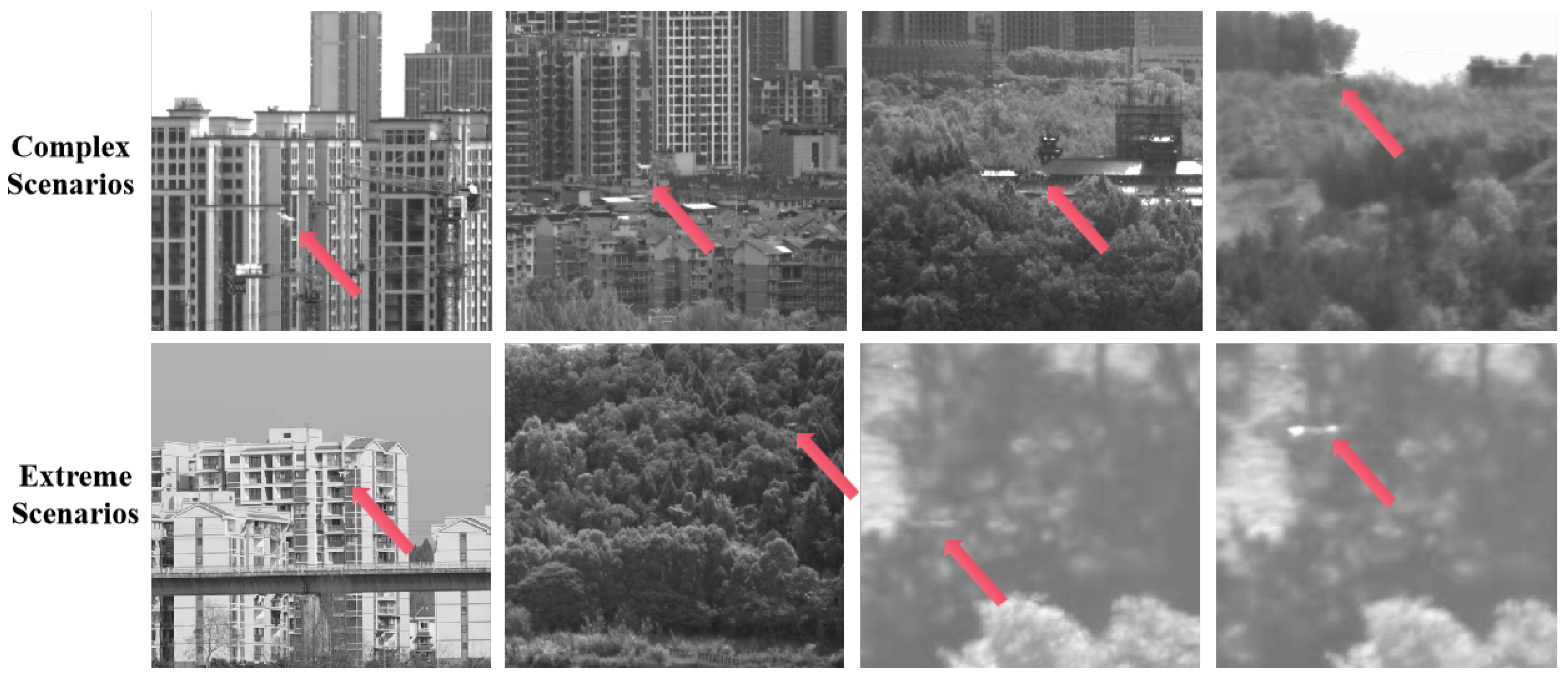
5.1. Dataset

This study constructs a diversified UAV dataset, Anti-UAV, for training and evaluating few-shot multi-target detection tasks. The dataset comprises a hybrid collection of both simulated and real-world data, incorporating six representative UAV models (DJI Phantom 4, Mavic, Matrix 200, FPV drones, etc.) across various operational scenarios. Specifically, the dataset contains carefully annotated samples from three major categories: (1) FPV racing drones (both simulated and real-world captured), (2) quadcopters (simulated and real-world), and (3) hexacopters (simulated and real-world), ordered from right to left in our statistical visualization.
The dataset features comprehensive variations including the following:
  • Diverse backgrounds (open sky, forest, urban environments);
  • Multiple motion patterns (level flight, complex maneuvers, rapid ascent/descent);
  • Balanced representation of simulated and real-world scenarios.
Notably, all targets maintain a relative width and height ratio of 0.02 to the image size, satisfying the critical requirements for few-shot small-target detection. As shown in Figure 6, our comprehensive analysis reveals the following: (a) the label distribution across categories, (b) feature correlation patterns, and (c) representative motion characteristics of simulated UAVs. The statistical breakdown demonstrates a balanced distribution between simulated and real-world samples within each UAV category, ensuring robust model training and evaluation.

5.2. Experiments

The model was trained on four NVIDIA A100 GPUs with a batch size of 128 for 300 epochs, using the SGD optimizer with betas = (0.9, 0.009), an initial learning rate of 0.01, and weight decay of 0.0005. Experiments were conducted on a simulation platform featuring an NVIDIA GeForce RTX 4080 GPU and an Intel® Core™ i9-13900H CPU, with CUDA 12.2 and TensorRT 8.6.1.6.
In the ablation study, we systematically evaluate three model variants:
  • D-Fine (Baseline): The original unmodified architecture employing standard IoU loss and a full feature pyramid (P3–P5 layers) for multi-scale detection. This model contains 4.0M parameters and serves as the reference benchmark.
  • D-Fine-NWD: Enhanced from D-Fine by replacing IoU loss with Normalized Wasserstein Distance (NWD) loss. This modification specifically addresses the sensitivity of small target localization while retaining the complete P3–P5 feature pyramid structure. The NWD loss models bounding boxes as Gaussian distributions to improve sub-pixel accuracy.
  • D-Fine-NWD-P2 (Proposed UAV-D-Fine): Built upon D-Fine-NWD with lightweight feature pyramid reconstruction:
    -
    Removes P4 and P5 detection layers;
    -
    Retains only high-resolution P2 (1/4 scale) and P3 (1/8 scale) features;
    -
    Implements optimized feature fusion: P o u t = Conv 3 × 3 ( UpSample ( P 3 ) P 2 ) .
  • D-Fine-NWD-P2-DSAM (Enhanced UAV-D-Fine): Extends D-Fine-NWD-P2 by integrating the Dynamic Spatial Attention Mechanism (DSAM) into the feature fusion pathway.
    This architecture achieves 85% parameter reduction (0.6 M params) while maintaining detection performance.
Detection performance is evaluated using mAP@50 and mAP@50:95 metrics, where higher values indicate better recognition accuracy. Tracking stability is quantified through Miss Distance (MD), measured in pixels, which captures positional deviations during continuous UAV tracking. Lower MD values reflect superior tracking precision.
As shown in Figure 7b,d, the mAP@50 values of D-Fine-NWD, D-Fine-NWD-P2, and D-Fine-NWD-P2-DSAM exhibit marginal differentiation, necessitating the introduction of the Miss Distance metric for finer discrimination of tracking stability. Additionally, the elevated validation loss of D-Fine-NWD, D-Fine-NWD-P2, and D-Fine-NWD-P2-DSAM compared to YOLOv11n and the baseline D-Fine in Figure 7a,c is attributed to the incorporation of NWD loss, which operates on a different numerical scale than the original loss.
Figure 8 presents the miss distance curves for the ablation models, calculated from 2281 validation images. Fixed vertical offsets are applied to differentiate the curves. The miss distance metric is critically introduced to address the limitations of conventional mAP evaluation in continuous tracking scenarios, particularly for laser-based UAV interception systems. During sustained laser engagement, the proximity between the targeting reticle (red crosshair) and the center of the UAV bounding box directly determines engagement efficacy. While mAP measures detection accuracy at discrete frames, it fails to quantify positional consistency during continuous tracking. Thus, we define the miss distance as follows:
M = 1 N c = 1 N ( x c x o ) 2 + ( y c y o ) 2
where M represents the average miss distance in pixels, N denotes the total number of frames in the tracking sequence, and c is the frame index. The coordinates ( x c , y c ) correspond to the detected target center in frame c, while ( x o , y o ) indicate the ground truth coordinates of the ideal laser targeting point in the same frame.
This pixel-based metric quantifies the root-mean-square positional deviation between two critical references: (1) the center point of the predicted bounding box ( x c , y c ) from the detection output, and (2) the ideal laser targeting point ( x o , y o ) required for effective engagement. Lower M values indicate superior tracking stability, which directly correlates with higher laser strike probability in practical interception scenarios.
Analysis of the ablation experiment results in Table 1 shows that D-Fine-NWD-P2, the optimized UAV-D-Fine model, achieves an 85% reduction in parameters (from 4.0 M to 0.6 M) through lightweight feature pyramid reconstruction, while maintaining high detection performance. Despite a slight increase in computational complexity (+7% GFlops), the final model delivers optimal results: 0.994 mAP@50, 0.804 mAP@50-95, and a miss distance of 2.98 pixels, confirming its superiority in few-shot UAV detection tasks. D-Fine-NWD-P2-DSAM with Dynamic Spatial Attention Mechanism (DSAM) achieves 0.810 mAP@50-95 (+0.6%) and 2.84 px tracking error (−4.7%) under 0.6 M parameters and 9.3 GFLOPs, maintaining real-time performance at 423 FPS. The results demonstrate DSAM’s effectiveness in motion interference scenarios.

5.3. UAV Tracking Test and Miss Distance Analysis Based on the Simulation System

To validate the robustness of the dynamic tracking algorithm for LSS UAVs, this study establishes a multi-physics coupled adversarial testing environment based on the AirSim simulation platform. A coarse/precise-TV dual-sensor collaborative tracking framework is used to quantitatively analyze the miss distance characteristics of the laser Acquisition, Tracking, and Pointing (ATP) system.
The coarse-TV system employs a wide-angle visible camera (focal length: 4 mm, FOV: 120°, resolution: 640 × 480, frame rate: 60 Hz) for coarse target acquisition at 1 km, while the precise-TV system integrates a telephoto visible camera (focal length: 50 mm, FOV: 30°, resolution: 640 × 480, frame rate: 120 Hz). UAVs perform constant-velocity linear flight at 8 m/s to assess baseline tracking stability.
Quantitative analysis using 1500 frames of data for three UAV targets (results shown in Table 2) demonstrates that our improved object detection and tracking algorithm achieves both high precision and stability while satisfying real-time processing requirements. The system effectively handles low-altitude UAV targets in complex backgrounds. In field experiments, the algorithm successfully captured UAV targets at 1 km range and maintained stable, continuous tracking. The final miss distance remained within the engagement requirements of the countermeasure system, ultimately enabling the successful neutralization of the target drone.

5.4. Result Analysis

We applied UAV-D-Fine to a real-world field experiment in a counter-UAV system. The algorithm achieved a tracking speed of 82 frames/s and a successful acquisition rate of 98.6%. It effectively detected small targets at a distance of 1 km, avoiding missed or false detections in complex backgrounds. The tracking miss distance was 0.590 pixels, meeting the strike requirements for counter-UAV systems. Visual tracking results for consecutive frames 202, 203, 204 and discrete frames 250, 260, 270 are shown in Figure 9.

6. Conclusions

This paper addresses the dynamic tracking challenge in laser counter-UAV systems for LSS UAVs, proposing a solution that integrates a lightweight detection algorithm with a multi-physics coupled simulation. The UAV-D-Fine detection model, based on the Transformer architecture, achieves an mAP50 of 0.994 with 0.6 M parameters, by utilizing a normalized Wasserstein loss function and feature pyramid reconstruction strategy. The miss distance is reduced by 32.2% (2.84 pixels) compared to the baseline model. A dynamic adversarial simulation environment is constructed on the AirSim platform, incorporating atmospheric turbulence, laser attenuation, and multimodal interference models to validate the closed-loop tracking of the laser ATP system. Field tests show a miss distance of ≤0.590 pixels at 1 km, meeting strike requirements. Future work will focus on multi-source interference modeling and energy efficiency optimization, advancing the algorithm’s engineering application on embedded platforms.
Although the proposed framework demonstrates high-precision tracking capabilities for low, slow, and small (LSS) drones in controlled environments, it still exhibits limitations in multi-target tracking constraints. The current methodology prioritizes tracking the drone closest to the center of the field of view (FOV) in multi-drone scenarios. However, this heuristic strategy may lead to tracking interruptions and erroneous locking onto secondary targets when detector failures occur (e.g., due to temporary occlusions), thereby compromising the continuity of laser strikes.

Author Contributions

Conceptualization, Z.Y. and J.Y.; methodology, Z.Y. and H.K.; software, J.G. and G.L.; validation, Z.Y., J.Y. and H.K.; formal analysis, H.K.; investigation, J.Y. and G.L.; resources, Z.Y. and H.K.; data curation, G.L.; writing—original draft preparation, Z.Y.; writing—review and editing, J.Y. and J.G.; visualization, Z.Y.; supervision, J.Y.; project administration, H.K.; funding acquisition, J.Y. All authors have read and agreed to the published version of the manuscript.

Funding

This research received no external funding.

Data Availability Statement

The datasets and code from this study are available from Z.Y. on reasonable request.

DURC Statement

Current research is limited to the field of modeling and simulation of laser countermeasure systems, which is beneficial for enhancing the precision and effectiveness of urban security measures against Low-Slow-Small UAVs and does not pose a direct threat to public health or national security. Authors acknowledge the dual-use potential of the research involving laser technology and UAV tracking and confirm that all necessary precautions have been taken to prevent potential misuse, such as restricting access to detailed laser system specifications and focusing on simulation rather than real-world deployment. As an ethical responsibility, authors strictly adhere to relevant national and international laws about DURC. Authors advocate for responsible deployment, ethical considerations, regulatory compliance, and transparent reporting to mitigate misuse risks and foster beneficial outcomes.

Acknowledgments

We would like to thank the Optical Control Group of the China Academy of Engineering Physics for their support.

Conflicts of Interest

The authors declare no conflicts of interest.

References

  1. Mohamed, N.; Al-Jaroodi, J.; Jawhar, I.; Idries, A.; Mohammed, F. Unmanned aerial vehicles applications in future smart cities. Technol. Forecast. Soc. Chang. 2020, 153, 119293. [Google Scholar] [CrossRef]
  2. Hu, N.; Li, Y.; Pan, W.; Shao, S.; Tang, Y.; Li, X. Geometric distribution of UAV detection performance by bistatic radar. IEEE Trans. Aerosp. Electron. Syst. 2023, 60, 2445–2452. [Google Scholar] [CrossRef]
  3. Chae, M.H.; Park, S.O.; Choi, S.H.; Choi, C.T. Reinforcement learning-based counter fixed-wing drone system using GNSS deception. IEEE Access 2024, 12, 16549–16558. [Google Scholar] [CrossRef]
  4. Kaushal, H.; Kaddoum, G. Applications of lasers for tactical military operations. IEEE Access 2017, 5, 20736–20753. [Google Scholar] [CrossRef]
  5. Wu, J.; Huang, S.; Wang, X.; Kou, Y.; Yang, W. Study on the Performance of Laser Device for Attacking Miniature UAVs. Optics 2024, 5, 378–391. [Google Scholar] [CrossRef]
  6. Jiang, N.; Wang, K.; Peng, X.; Yu, X.; Wang, Q.; Xing, J.; Li, G.; Guo, G.; Ye, Q.; Jiao, J.; et al. Anti-UAV: A large-scale benchmark for vision-based UAV tracking. IEEE Trans. Multimed. 2021, 25, 486–500. [Google Scholar] [CrossRef]
  7. Weyrauch, T.; Vorontsov, M.A.; Carhart, G.W.; Beresnev, L.A.; Rostov, A.P.; Polnau, E.E.; Liu, J.J. Experimental demonstration of coherent beam combining over a 7 km propagation path. Opt. Lett. 2011, 36, 4455–4457. [Google Scholar] [CrossRef] [PubMed]
  8. Vaswani, A.; Shazeer, N.; Parmar, N.; Uszkoreit, J.; Jones, L.; Gomez, A.N.; Kaiser, Ł.; Polosukhin, I. Attention is all you need. In Proceedings of the Advances in Neural Information Processing Systems 30 (NIPS 2017), Long Beach, CA, USA, 4–9 December 2017. [Google Scholar]
  9. Shah, S.; Dey, D.; Lovett, C.; Kapoor, A. Airsim: High-fidelity visual and physical simulation for autonomous vehicles. In Field and Service Robotics: Results of the 11th International Conference; Springer: Cham, Switzerland, 2018; pp. 621–635. [Google Scholar]
  10. Madaan, R.; Gyde, N.; Vemprala, S.; Brown, M.; Nagami, K.; Taubner, T.; Cristofalo, E.; Scaramuzza, D.; Schwager, M.; Kapoor, A. Airsim drone racing lab. In Proceedings of the Neurips 2019 competition and demonstration track, Vancouver, CA, USA, 8–14 December 2019; pp. 177–191. [Google Scholar]
  11. Chao, Y.; Dillmann, R.; Roennau, A.; Xiong, Z. E-DQN-Based Path Planning Method for Drones in Airsim Simulator under Unknown Environment. Biomimetics 2024, 9, 238. [Google Scholar] [CrossRef] [PubMed]
  12. Shen, S.E.; Huang, Y.C. Application of reinforcement learning in controlling quadrotor UAV flight actions. Drones 2024, 8, 660. [Google Scholar] [CrossRef]
  13. Shimada, T.; Nishikawa, H.; Kong, X.; Tomiyama, H. Pix2pix-based monocular depth estimation for drones with optical flow on airsim. Sensors 2022, 22, 2097. [Google Scholar] [CrossRef] [PubMed]
  14. Mittal, P.; Sharma, A.; Singh, R. A simulated dataset in aerial images using simulink for object detection and recognition. Int. J. Cogn. Comput. Eng. 2022, 3, 144–151. [Google Scholar] [CrossRef]
  15. Rui, C.; Youwei, G.; Huafei, Z.; Hongyu, J. A comprehensive approach for UAV small object detection with simulation-based transfer learning and adaptive fusion. arXiv 2021, arXiv:2109.01800. [Google Scholar]
  16. Wang, B.; Li, Q.; Mao, Q.; Wang, J.; Chen, C.P.; Shangguan, A.; Zhang, H. A Survey on Vision-Based Anti Unmanned Aerial Vehicles Methods. Drones 2024, 8, 518. [Google Scholar] [CrossRef]
  17. Wang, C.Y.; Bochkovskiy, A.; Liao, H.Y.M. YOLOv7: Trainable bag-of-freebies sets new state-of-the-art for real-time object detectors. In Proceedings of the IEEE/CVF conference on computer vision and pattern recognition, Vancouver, BC, Canada, 17–24 June 2023; pp. 7464–7475. [Google Scholar]
  18. Khanam, R.; Hussain, M. Yolov11: An overview of the key architectural enhancements. arXiv 2024, arXiv:2410.17725. [Google Scholar]
  19. Hu, Y.; Wu, X.; Zheng, G.; Liu, X. Object detection of UAV for anti-UAV based on improved YOLO v3. In Proceedings of the 2019 Chinese Control Conference (CCC), Guangzhou, China, 27–30 July 2019; pp. 8386–8390. [Google Scholar]
  20. Cheng, Q.; Li, J.; Du, J.; Li, S. Anti-UAV Detection Method Based on Local-Global Feature Focusing Module. In Proceedings of the 2024 IEEE 7th Advanced Information Technology, Electronic and Automation Control Conference (IAEAC), Chongqing, China, 15–17 March 2024; Volume 7, pp. 1413–1418. [Google Scholar] [CrossRef]
  21. Li, Y.; Yuan, D.; Sun, M.; Wang, H.; Liu, X.; Liu, J. A global-local tracking framework driven by both motion and appearance for infrared anti-uav. In Proceedings of the IEEE/CVF Conference on Computer Vision and Pattern Recognition, Vancouver, BC, Canada, 17–24 June 2023; pp. 3026–3035. [Google Scholar]
  22. Khalighi, M.A.; Uysal, M. Survey on free space optical communication: A communication theory perspective. IEEE Commun. Surv. Tutor. 2014, 16, 2231–2258. [Google Scholar] [CrossRef]
  23. Berk, A.; Anderson, G.P.; Acharya, P.K.; Bernstein, L.S.; Muratov, L.; Lee, J.; Fox, M.J.; Adler-Golden, S.M.; Chetwynd, J.H.; Hoke, M.L.; et al. MODTRAN 5: A reformulated atmospheric band model with auxiliary species and practical multiple scattering options: Update. In Proceedings of the Algorithms and Technologies for Multispectral, Hyperspectral, and Ultraspectral Imagery XI, Orlando, FL, USA, 28 March–1 April 2005; Volume 5806. [Google Scholar] [CrossRef]
  24. Multiphysics, C. Introduction to Comsol Multiphysics®; COMSOL Multiphysics: Burlington, MA, USA, 1998; Volume 9, p. 32. [Google Scholar]
  25. Madenci, E.; Guven, I. The Finite Element Method and Applications in Engineering Using ANSYS®; Springer: New York, NY, USA, 2015. [Google Scholar]
  26. Coluccelli, N. Nonsequential modeling of laser diode stacks using Zemax: Simulation, optimization, and experimental validation. Appl. Opt. 2010, 49, 4237–4245. [Google Scholar] [CrossRef] [PubMed]
  27. Hu, X.; Wang, W.; Li, J.; Gao, B.; Li, H. Research on a Method for Realizing Three-Dimensional Real-Time Cloud Rendering Based on Cesium. In Proceedings of the 2024 4th International Conference on Electronic Information Engineering and Computer Science (EIECS), Yanji, China, 27–29 September 2024; pp. 224–228. [Google Scholar] [CrossRef]
  28. Zhuang, Z.; Guo, R.; Huang, Z.; Zhang, Y.; Tian, B. UAV Localization Using Staring Radar Under Multipath Interference. In Proceedings of the IGARSS 2022–2022 IEEE International Geoscience and Remote Sensing Symposium, Kuala Lumpur, Malaysia, 17–22 July 2022; pp. 2291–2294. [Google Scholar]
  29. Jiang, W.; Liu, Z.; Wang, Y.; Lin, Y.; Li, Y.; Bi, F. Realizing Small UAV Targets Recognition via Multi-Dimensional Feature Fusion of High-Resolution Radar. Remote Sens. 2024, 16, 2710. [Google Scholar] [CrossRef]
  30. Peng, Y.; Li, H.; Wu, P.; Zhang, Y.; Sun, X.; Wu, F. D-FINE: Redefine regression Task in DETRs as Fine-grained distribution refinement. arXiv 2024, arXiv:2410.13842. [Google Scholar]
Figure 1. Drone target diagram in real-world scenarios.
Drones 09 00419 g001
Figure 2. Simulation architecture diagram.
Drones 09 00419 g002
Figure 3. Integrated Workflow of 3D geospatial modeling and drone target simulation. If there are multiple panels, they should be listed as follows: (a) Cesium 3D Earth. (b) Geospatial Registration and Coordinate Transformation. (c) Dynamic Tessellation Loading Mechanism for 3D Content. (d) Drone Target Model Modeling.
Drones 09 00419 g003
Figure 4. UAV-D-fine network model.
Drones 09 00419 g004
Figure 5. Dynamic spatial attention mechanism (DSAM) diagram.
Drones 09 00419 g005
Figure 6. Label visualization and correlation analysis framework for drone target simulation.
Drones 09 00419 g006
Figure 7. Training dynamics of ablation models: (a) validation loss over full 300 epochs; (b) mAP@50 progression during full training; (c) validation loss convergence in final 50 epochs; (d) mAP@50 stabilization in final 50 epochs. Note the elevated loss curves for NWD-based models stem from the different numerical scale of NWD loss.
Drones 09 00419 g007
Figure 8. Miss distance of each model in the ablation experiments.
Drones 09 00419 g008
Figure 9. Visualization of algorithm tracking UAV effect after optimization.
Drones 09 00419 g009
Table 1. Ablation study results.
ModelsParams (M)GFLOPsmAP@50mAP@50-95Miss Distance (px)FPS (4080)
YOLOv11n2.97.60.9850.7814.19375
D-Fine4.07.00.9880.7864.15390
D-Fine-NWD4.07.00.9940.7973.85390
D-Fine-NWD-P20.69.10.9940.8042.98433
D-Fine-NWD-P2-DSAM0.69.30.9940.8102.84423
Table 2. Coarse and precise track miss distance sequences for different UAVs.
UAV ModelCoarse Track Miss Distance SequencePrecise Track Miss Distance Sequence
DJI Phantom 4Drones 09 00419 i001Drones 09 00419 i002
MavicDrones 09 00419 i003Drones 09 00419 i004
Matrix 200Drones 09 00419 i005Drones 09 00419 i006
Disclaimer/Publisher’s Note: The statements, opinions and data contained in all publications are solely those of the individual author(s) and contributor(s) and not of MDPI and/or the editor(s). MDPI and/or the editor(s) disclaim responsibility for any injury to people or property resulting from any ideas, methods, instructions or products referred to in the content.

