
An Innovative Method of Monitoring Cotton Aphid Infestation Based on Data Fusion and Multi-Source Remote Sensing Using Unmanned Aerial Vehicles

 , , ,
, , , 
Abstract
1. Introduction
2. Materials and Methods
2.1. Study Area
2.2. Data Acquisition
2.2.1. UAV Image Acquisition
2.2.2. Cotton Aphid Field Survey Data Collection
2.2.3. Data Pre-Processing
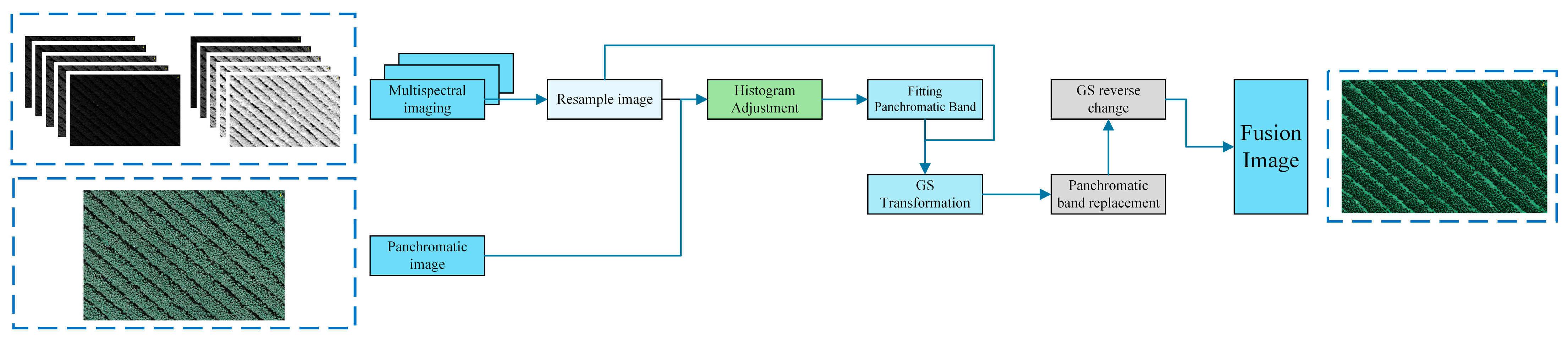
2.2.4. Image Fusion and Alignment
2.2.5. Cotton Aphid Vegetation Index Construction
2.3. Data Analysis and Machine Learning Model Construction
2.4. Model Accuracy Evaluation
3. Results
3.1. Spectral Characterization of Cotton Canopies with Different Aphid Infestation Classes
3.2. Data Modeling
3.2.1. Correlation Analysis
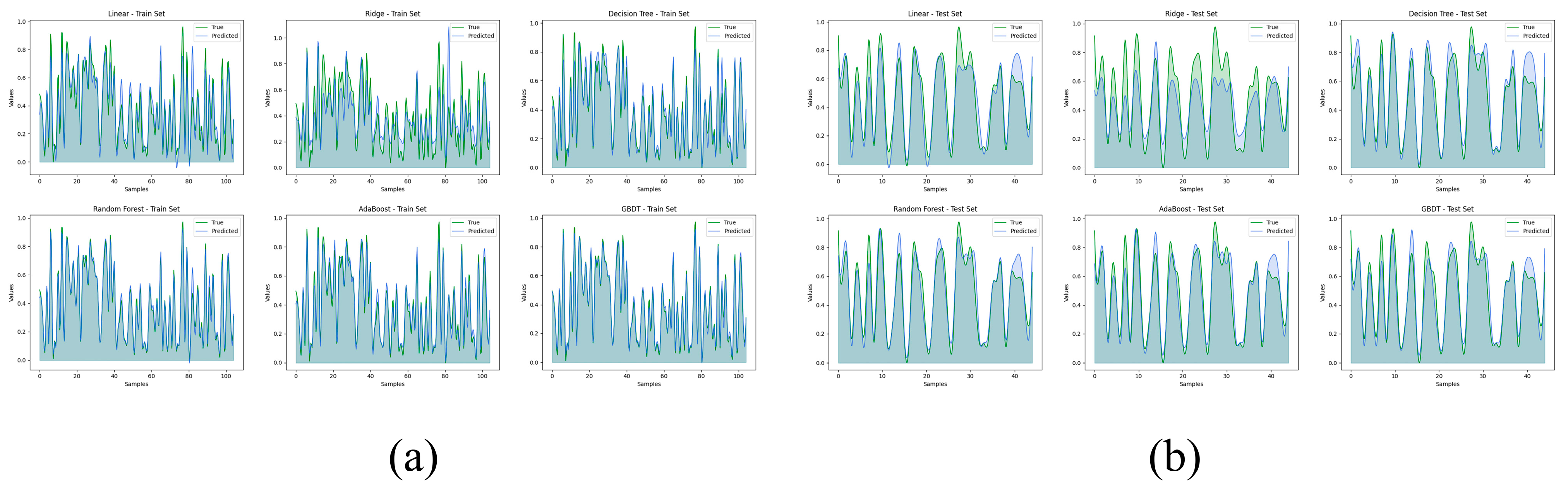
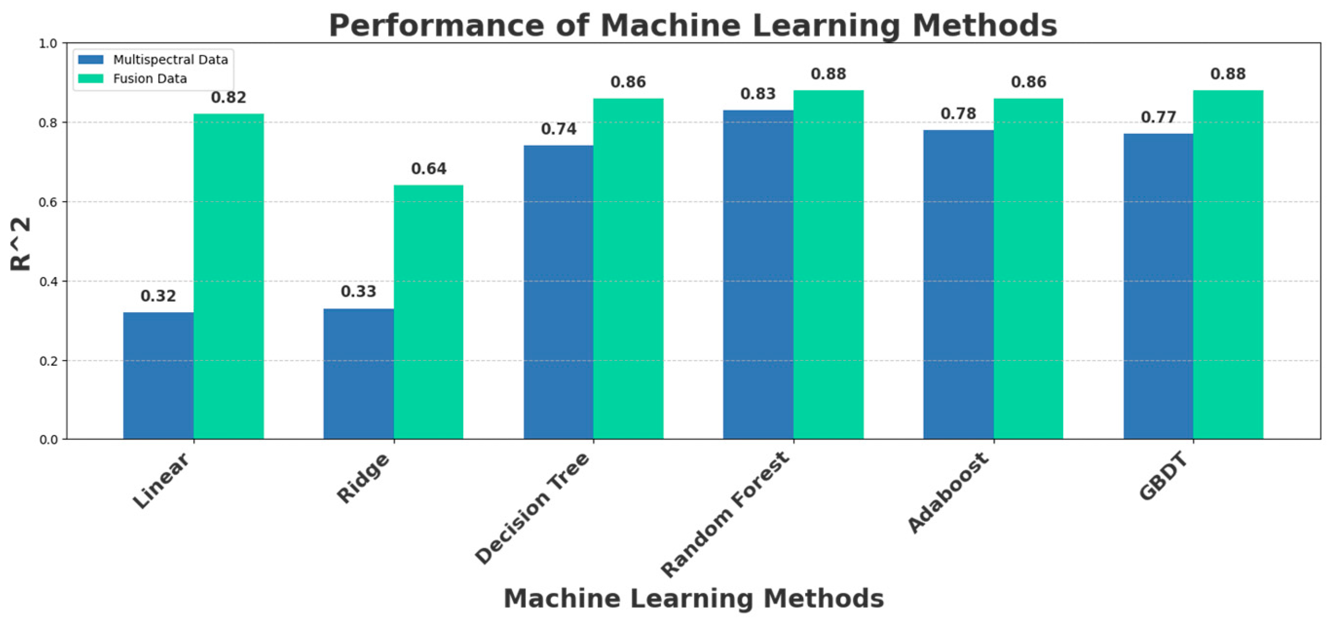
3.2.2. Machine Learning Modeling Comparison
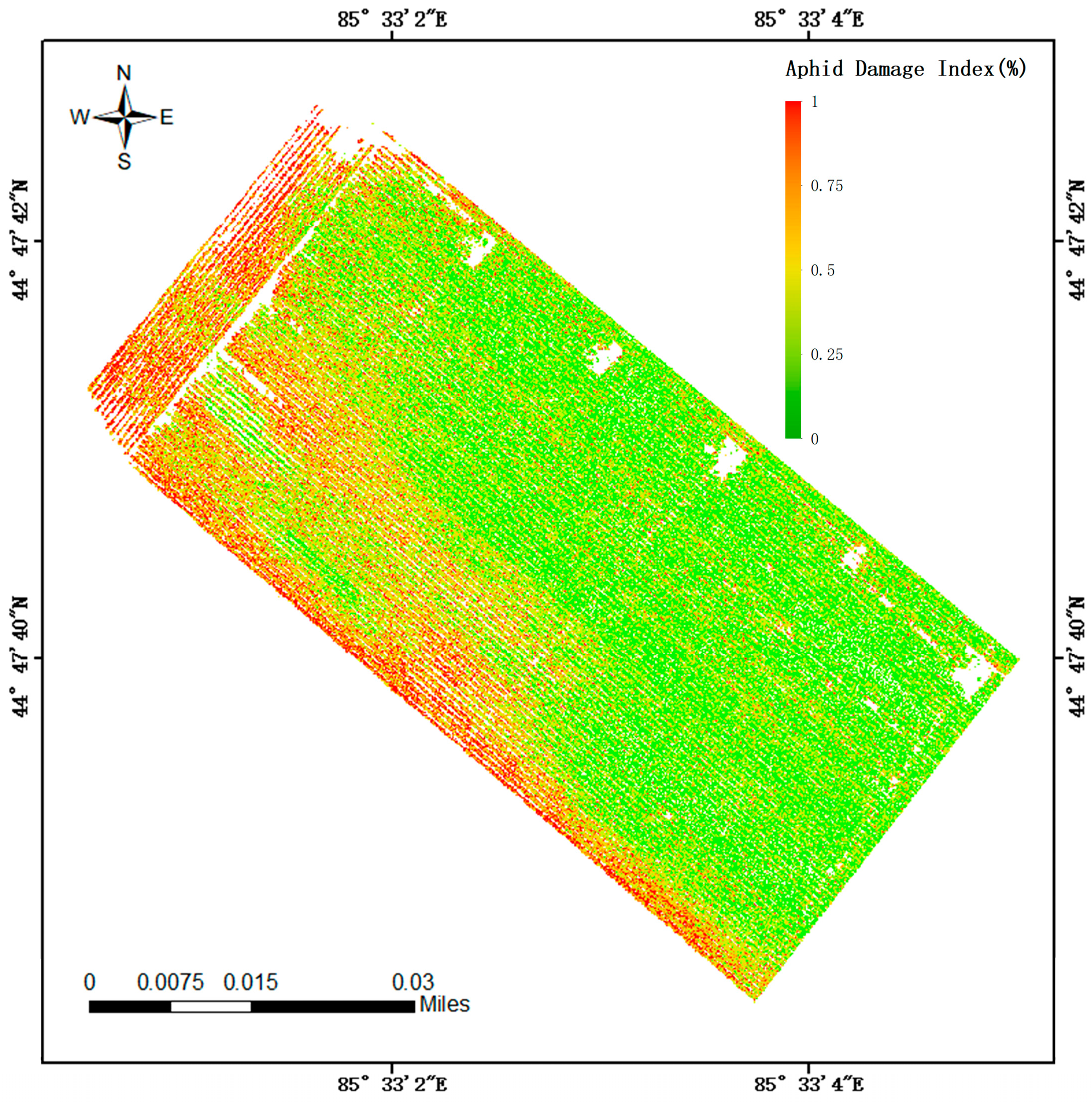
3.3. Cotton Aphid Damage Model Evaluation
4. Discussion
5. Conclusions
Author Contributions
Funding
Data Availability Statement
Acknowledgments
Conflicts of Interest
References
- Prabhakar, M.; Prasad, Y.G.; Vennila, S.; Thirupathi, M.; Sreedevi, G.; Rao, G.R.; Venkateswarlu, B. Hyperspectral indices for assessing damage by the solenopsis mealybug (Hemiptera: Pseudococcidae) in cotton. Comput. Electron. Agric. 2013, 97, 61–70. [Google Scholar] [CrossRef]
- Subramanian, K.S.; Pazhanivelan, S.; Srinivasan, G.; Santhi, R.; Sathiah, N. Drones in Insect Pest Management. Front. Agron. 2021, 3, 640885. [Google Scholar] [CrossRef]
- Chen, M.; Chen, Z.; Luo, L.; Tang, Y.; Cheng, J.; Wei, H.; Wang, J. Dynamic visual servo control methods for continuous operation of a fruit harvesting robot working throughout an orchard. Comput. Electron. Agric. 2024, 219, 108774. [Google Scholar]
- Jamal Jumaah, H.; Adnan Rashid, A.; Abdul Razzaq Saleh, S.; Jamal Jumaah, S. Deep Neural Remote Sensing and Sentinel-2 Satellite Image Processing of Kirkuk City, Iraq for Sustainable Prospective. J. Opt. Photonics Res. 2024. [Google Scholar] [CrossRef]
- Zhang, Z.; Li, Z.; Ma, L.; Lv, X.; Zhang, L. Definition Management Zones of Drip Irrigation Cotton Field Based on the GIS and RS. In Computer and Computing Technologies in Agriculture X; Li, D., Ed.; Springer International Publishing: Cham, Switzerland, 2019; pp. 508–517. [Google Scholar] [CrossRef]
- Chao, D.; Wenjiang, H.; Shuang, Z.; Biyao, Z.; Yao, L.; Fang, H.; Yuanyuan, M. Greenup dates change across a temperate forest-grassland ecotone in northeastern China driven by spring temperature and tree cover. Agric. For. Meteorol. 2022, 314, 108780. [Google Scholar] [CrossRef]
- Palanisamy, S.; Selvaraj, R.; Ramesh, T.; Ponnusamy, J. Applications of Remote Sensing in Agriculture—A Review. Int. J. Curr. Microbiol. Appl. Sci. 2019, 8, 2270–2283. [Google Scholar] [CrossRef]
- Brinatti Vazquez, G.D.; Lacapmesure, A.M.; Martínez, S.; Martínez, O.E. SUPPOSe 3Dge: A Method for Super-Resolved Detection of Surfaces in Volumetric Fluorescence Microscopy. J. Opt. Photonics Res. 2024. [Google Scholar] [CrossRef]
- Jingcheng, Z.; Yanbo, H.; Ruiliang, P.; Pablo, G.-M.; Lin, Y.; Kaihua, W.; Wenjiang, H. Monitoring plant diseases and pests through remote sensing technology: A review. Comput. Electron. Agric. 2019, 165, 104943. [Google Scholar] [CrossRef]
- Li, X.; Hu, Y.; Jie, Y.; Zhao, C.; Zhang, Z. Dual-Frequency Lidar for Compressed Sensing 3D Imaging Based on All-Phase Fast Fourier Transform. J. Opt. Photonics Res. 2023, 1, 74–81. [Google Scholar] [CrossRef]
- Cocuzza, G. Aphis gossypii (cotton aphid). In Pest, Natural Enemy, Invasive Species, Vector of Plant Pest (CABI Compendium); CABI: Wallingford, UK, 2024. [Google Scholar]
- Li, X.; Liang, Z.; Yang, G.; Lin, T.; Liu, B. Assessing the Severity of Verticillium Wilt in Cotton Fields and Constructing Pesticide Application Prescription Maps Using Unmanned Aerial Vehicle (UAV) Multispectral Images. Drones 2024, 8, 176. [Google Scholar] [CrossRef]
- Abdollahnejad, A.; Panagiotidis, D. Tree Species Classification and Health Status Assessment for a Mixed Broadleaf-Conifer Forest with UAS Multispectral Imaging. Remote Sens. 2020, 12, 3722. [Google Scholar] [CrossRef]
- Hu, X.; Qiao, H.; Chen, B.; Si, H. A Novel Approach to Grade Cotton Aphid Damage Severity with Hyperspectral Index Reconstruction. Appl. Sci. 2022, 12, 8760. [Google Scholar] [CrossRef]
- Guo, W.; Qiao, H.-b.; Zhao, H.-q.; Zhang, J.-j.; Pei, P.-c.; Liu, Z.-l. Cotton aphid damage monitoring using UAV hyperspectral data based on derivative of ratio spectroscopy. Spectrosc. Spectr. Anal. 2021, 41, 1543–1550. [Google Scholar]
- Bandara, W.G.C.; Patel, V.M. Hypertransformer: A textural and spectral feature fusion transformer for pansharpening. In Proceedings of the IEEE/CVF Conference on Computer Vision and Pattern Recognition, New Orleans, LA, USA, 18–24 June 2022; pp. 1767–1777. [Google Scholar]
- Zhang, C.; Chen, Y.; Yang, X.; Gao, S.; Li, F.; Kong, A.; Zu, D.; Sun, L. Improved Remote Sensing Image Classification Based on Multi-Scale Feature Fusion. Remote Sens. 2020, 12, 213. [Google Scholar] [CrossRef]
- Jiang, P.; Zhou, X.; Liu, T.; Guo, X.; Ma, D.; Zhang, C.; Li, Y.; Liu, S. Prediction Dynamics in Cotton Aphid Using Unmanned Aerial Vehicle Multispectral Images and Vegetation Indices. IEEE Access 2023, 11, 5908–5918. [Google Scholar] [CrossRef]
- Chen, Z.; Wu, R.; Lin, Y.; Li, C.; Chen, S.; Yuan, Z.; Chen, S.; Zou, X. Plant Disease Recognition Model Based on Improved YOLOv5. Agronomy 2022, 12, 365. [Google Scholar] [CrossRef]
- Xu, W.; Chen, P.; Zhan, Y.; Chen, S.; Zhang, L.; Lan, Y. Cotton yield estimation model based on machine learning using time series UAV remote sensing data. Int. J. Appl. Earth Obs. Geoinf. 2021, 104, 102511. [Google Scholar] [CrossRef]
- Xiang, J.; Liu, J.; Chen, D.; Xiong, Q.; Deng, C. CTFuseNet: A Multi-Scale CNN-Transformer Feature Fused Network for Crop Type Segmentation on UAV Remote Sensing Imagery. Remote Sens. 2023, 15, 1151. [Google Scholar] [CrossRef]
- Bao, W.; Cheng, T.; Zhou, X.-G.; Guo, W.; Wang, Y.; Zhang, X.; Qiao, H.; Zhang, D. An improved DenseNet model to classify the damage caused by cotton aphid. Comput. Electron. Agric. 2022, 203, 107485. [Google Scholar] [CrossRef]
- Kong, Y.; Hong, F.; Leung, H.; Peng, X. A Fusion Method of Optical Image and SAR Image Based on Dense-UGAN and Gram–Schmidt Transformation. Remote Sens. 2021, 13, 4274. [Google Scholar] [CrossRef]
- Pohl, C.; Van Genderen, J. Remote Sensing Image Fusion: A Practical Guide; CRC Press: Boca Raton, FL, USA, 2016. [Google Scholar] [CrossRef]
- Maurer, T. How to Pan-Sharpen Images Using the Gram-Schmidt Pan-Sharpen Method—A Recipe. Int. Arch. Photogramm. Remote Sens. Spat. Inf. Sci. 2013, 40, 239–244. [Google Scholar] [CrossRef]
- Zheng, Q.; Huang, W.; Cui, X.; Dong, Y.; Shi, Y.; Ma, H.; Liu, L. Identification of Wheat Yellow Rust Using Optimal Three-Band Spectral Indices in Different Growth Stages. Sensors 2019, 19, 35. [Google Scholar] [CrossRef]
- Liu, L.; Dong, Y.; Huang, W.; Du, X.; Ren, B.; Huang, L.; Zheng, Q.; Ma, H. A Disease Index for Efficiently Detecting Wheat Fusarium Head Blight Using Sentinel-2 Multispectral Imagery. IEEE Access 2020, 8, 52181–52191. [Google Scholar] [CrossRef]
- Guomin, S.; Wenting, H.; Huihui, Z.; Shouyang, L.; Yi, W.; Liyuan, Z.; Xin, C. Mapping maize crop coefficient Kc using random forest algorithm based on leaf area index and UAV-based multispectral vegetation indices. Agric. Water Manag. 2021, 252, 106906. [Google Scholar] [CrossRef]
- Zhi, J.; Dong, Y.; Lu, L.; Shi, J.; Luo, W.; Zhou, Y.; Geng, T.; Xia, J.; Jia, C. High-precision extraction method for maize planting information based on UAV RGB images. Trans. Chin. Soc. Agric. Eng. 2021, 37, 48–54. [Google Scholar] [CrossRef]
- Guo, Z.-c.; Wang, T.; Liu, S.-l.; Kang, W.-p.; Chen, X.; Feng, K.; Zhang, X.-q.; Zhi, Y. Biomass and vegetation coverage survey in the Mu Us sandy land—based on unmanned aerial vehicle RGB images. Int. J. Appl. Earth Obs. Geoinf. 2021, 94, 102239. [Google Scholar] [CrossRef]
- Gitelson, A.A.; Merzlyak, M.N.; Chivkunova, O.B. Optical Properties and Nondestructive Estimation of Anthocyanin Content in Plant Leaves. Photochem. Photobiol. 2001, 74, 38–45. [Google Scholar] [CrossRef]
- Louhaichi, M.; Borman, M.M.; Johnson, D.E. Spatially Located Platform and Aerial Photography for Documentation of Grazing Impacts on Wheat. Geocarto Int. 2001, 16, 65–70. [Google Scholar] [CrossRef]
- Aoki, M.; Yabuki, K.; Totsuka, T.; Nishida, M. Remote sensing of chlorophyll content of leaf (I) effective spectral reflection characteristics of leaf for the evaluation of chlorophyll content in leaves of dicotyledons. Environ. Control Biol. 1986, 24, 21–26. [Google Scholar] [CrossRef]
- Pearson, R.L.; Miller, L.D. Remote mapping of standing crop biomass for estimation of the productivity of the shortgrass prairie, Pawnee National Grasslands, Colorado. In Proceedings of the Eighth International Symposium on Remote Sensing of Environment, Ann Arbor, MI, USA, 2–6 October 1972. [Google Scholar]
- Jordan, C.F. Derivation of Leaf-Area Index from Quality of Light on the Forest Floor. Ecology 1969, 50, 663–666. [Google Scholar] [CrossRef]
- Kaufman, Y.J.; Tanre, D. Atmospherically resistant vegetation index (ARVI) for EOS-MODIS. IEEE Trans. Geosci. Remote Sens. 1992, 30, 261–270. [Google Scholar] [CrossRef]
- Huete, A.R. A soil-adjusted vegetation index (SAVI). Remote Sens. Environ. 1988, 25, 295–309. [Google Scholar] [CrossRef]
- Haboudane, D.; Miller, J.R.; Tremblay, N.; Zarco-Tejada, P.J.; Dextraze, L. Integrated narrow-band vegetation indices for prediction of crop chlorophyll content for application to precision agriculture. Remote Sens. Environ. 2002, 81, 416–426. [Google Scholar] [CrossRef]
- Ren, L.; Ma, Y.; Shi, H.; Chen, X. Overview of Machine Learning Algorithms. In Signal and Information Processing, Networking and Computers; Wang, Y., Fu, M., Xu, L., Zou, J., Eds.; Springer: Singapore, 2020; pp. 672–678. [Google Scholar] [CrossRef]
- Yao, C.; Zhang, Y.; Zhang, Y.; Liu, H. Application of Convolutional Neural Network in Classification of High Resolution Agricultural Remote Sensing Images. Int. Arch. Photogramm. Remote Sens. Spat. Inf. Sci. 2017, 42, 989–992. [Google Scholar] [CrossRef]
- Chen, B.; Wang, K.-r.; Li, S.-k.; Jing, X.; Chen, J.-l.; Su, Y. Study on spectrum characteristics of cotton leaf and its estimating with remote sensing under aphid stress. Spectrosc. Spectr. Anal. 2010, 30, 3093–3097. [Google Scholar] [CrossRef]
- Chen, B.; Wang, Q.; Wang, J.; Liu, T.; Yu, Y.; Song, Y.; Chen, Z.; Bai, Z. The Estimate Severity Level of Cotton Verticillium Wilt Using New Multi-spectra of UAV Comprehensive Monitoring Disease Index. In Proceedings of the 2023 International Seminar on Computer Science and Engineering Technology (SCSET), New York, NY, USA, 29–30 April 2023; pp. 520–527. [Google Scholar] [CrossRef]
- Zhang, S.; Han, Y.; Wang, H.; Hou, D. Gram-Schmidt Remote Sensing Image Fusion Algorithm Based on Matrix Elementary Transformation. J. Phys. Conf. Ser. 2022, 2410, 012013. [Google Scholar] [CrossRef]


| Band | Center Wavelength (nm) | Wavelength Width (nm) |
|---|---|---|
| Coastal blue * | 444 | 28 |
| Blue | 475 | 32 |
| Green * | 531 | 14 |
| Green | 560 | 27 |
| Red * | 650 | 16 |
| Red | 668 | 14 |
| Red Edge * | 705 | 10 |
| Red Edge | 717 | 12 |
| Near-IR * | 740 | 18 |
| Near-IR | 842 | 57 |
| Aphid Level | Criteria |
|---|---|
| 0 | No aphids, flat leaves |
| 1 | Aphids are present; leaves are not damaged |
| 2 | There are aphids, and the leaves that are most seriously affected are wrinkled or slightly curled, almost semicircular. |
| 3 | There are aphids, and the leaves that are most seriously affected are curled to half a circle or more, forming an arc shape. |
| 4 | There are aphids, and the leaves that are most seriously affected are completely curled and ball-shaped. |
| Vegetation Index | Formula | References |
|---|---|---|
| ARI (Atmospheric Resistance Index) | [31] | |
| GLI (Green Leaf Index) | [32] | |
| GBI (Green Biome Index) | [33] | |
| RVI (Ratio Vegetation Index) | [34] | |
| DVI (Difference vegetation index) | [35] | |
| ARVI (Atmospherically Resistant Vegetation Index) | [36] | |
| GNDVI (Green Normalized Difference Vegetation Index) | [32] | |
| SAVI (Soil-Adjusted Vegetation Index) | [37] | |
| SIPI (Structure-Insensitive Pigment Index) | [38] | |
| TCARI (Transformed Chlorophyll Absorption in Reflectance Index) | [38] |
| Multispectral Images | Fused Images | ||
|---|---|---|---|
| Vegetation Index | Correlation Coefficient | Vegetation Index | Correlation Coefficient |
| ARVI | −0.77 *** | GLI | −0.89 *** |
| SAVI | −0.68 *** | RVI | 0.83 *** |
| GBI | −0.66 *** | DVI | −0.79 *** |
| ARVI | −0.60 *** | SAVI | −0.78 *** |
| Methods | R2 Before Fusion | Fused R2 | Gain After Fusion |
|---|---|---|---|
| Linear | 0.32 | 0.82 | +0.5 |
| Ridge | 0.33 | 0.64 | +0.31 |
| Decision Tree | 0.74 | 0.86 | +0.12 |
| Random Forest | 0.83 | 0.88 | +0.05 |
| Adaboost | 0.78 | 0.86 | +0.09 |
| GBDT | 0.77 | 0.88 | +0.11 |
Disclaimer/Publisher’s Note: The statements, opinions and data contained in all publications are solely those of the individual author(s) and contributor(s) and not of MDPI and/or the editor(s). MDPI and/or the editor(s) disclaim responsibility for any injury to people or property resulting from any ideas, methods, instructions or products referred to in the content. |
© 2025 by the authors. Licensee MDPI, Basel, Switzerland. This article is an open access article distributed under the terms and conditions of the Creative Commons Attribution (CC BY) license (https://creativecommons.org/licenses/by/4.0/).
Share and Cite
Ren, C.; Liu, B.; Liang, Z.; Lin, Z.; Wang, W.; Wei, X.; Li, X.; Zou, X. An Innovative Method of Monitoring Cotton Aphid Infestation Based on Data Fusion and Multi-Source Remote Sensing Using Unmanned Aerial Vehicles. Drones 2025, 9, 229. https://doi.org/10.3390/drones9040229
Ren C, Liu B, Liang Z, Lin Z, Wang W, Wei X, Li X, Zou X. An Innovative Method of Monitoring Cotton Aphid Infestation Based on Data Fusion and Multi-Source Remote Sensing Using Unmanned Aerial Vehicles. Drones. 2025; 9(4):229. https://doi.org/10.3390/drones9040229
Chicago/Turabian StyleRen, Chenning, Bo Liu, Zhi Liang, Zhonglong Lin, Wei Wang, Xinzheng Wei, Xiaojuan Li, and Xiangjun Zou. 2025. "An Innovative Method of Monitoring Cotton Aphid Infestation Based on Data Fusion and Multi-Source Remote Sensing Using Unmanned Aerial Vehicles" Drones 9, no. 4: 229. https://doi.org/10.3390/drones9040229
APA StyleRen, C., Liu, B., Liang, Z., Lin, Z., Wang, W., Wei, X., Li, X., & Zou, X. (2025). An Innovative Method of Monitoring Cotton Aphid Infestation Based on Data Fusion and Multi-Source Remote Sensing Using Unmanned Aerial Vehicles. Drones, 9(4), 229. https://doi.org/10.3390/drones9040229