Article

EuroDRONE, a European Unmanned Traffic Management Testbed for U-Space †

1
Department of Aerospace Science & Technology, National & Kapodistrian University of Athens, 10563 Athens, Greece
2
Applied Mechanics Lab, University of Patras, 26504 Patras, Greece
3
School of Aerospace, Manufacturing and Transport, Cranfield University, Bedford MK43 0AL, UK
4
Dronsystems Limited, 71–75 Shelton Street, London WC2H 9JQ, UK
5
Aslogic, Av Electricidad, 1–21, Planta 2, Puerta 1, 08191 Rubí, Barcelona, Spain
6
Hellenic Civil Aviation Authority, 10563 Athens, Greece
7
Hellenic Post, 10563 Athens, Greece
8
Romanian Post, 999032 Bucharest, Romania
*
Author to whom correspondence should be addressed.
This paper is partially based on the conference paper, which was submitted to the 2020 International Conference on Unmanned Aircraft Systems (ICUAS).
Drones 2022, 6(2), 53; https://doi.org/10.3390/drones6020053
Submission received: 9 January 2022 / Revised: 9 February 2022 / Accepted: 11 February 2022 / Published: 18 February 2022
(This article belongs to the Section Drone Design and Development)

Abstract

:
EuroDRONE is an Unmanned Traffic Management (UTM) demonstration project, funded by the EU’s SESAR organization, and its aim is to test and validate key UTM technologies for Europe’s ‘U-Space’ UTM program. The EuroDRONE UTM architecture comprises cloud software (DroNav) and hardware (transponder) to be installed on drones. The proposed EuroDRONE system is a Highly Automated Air Traffic Management System for small UAVs operating at low altitudes. It is a sophisticated, self-learning system based on software and hardware elements, operating in a distributed computing environment, offering multiple levels of redundancy, fail-safe algorithms for conflict prevention/resolution and assets management. EuroDRONE focuses its work on functionalities which involve the use of new communication links, the use of vehicle-to-infrastructure (V2I) and vehicle-to-vehicle (V2V) technology to communicate information between drones and operators for safe and effective UTM functionality. Practical demonstrations that took place in Patras/Messolonghi in 2019 are presented and show the benefits and shortcomings of near-term UTM implementation in Europe.

1. Introduction

The EuroDRONE demonstration, along with several similar projects around the EU, aims to examine the applicability of different Unmanned Traffic Management (UTM) concepts, technologies, and architectures, to promote the cooperation of the relevant stakeholders and to identify needs, problems, misconceptions that need to be addressed before Europe’s UTM framework ‘U-space’ can be successfully realised [1,2,3,4,5,6,7,8,9]. EuroDRONE’s objective is to develop, mature and qualify U-Space functionalities as provided by SESAR Joint Undertaking (JU) and test them in Greece [4]. EuroDRONE focuses on ‘Focus area 2: Urban U-space, a framework for urban traffic management of drones’ and addresses the functionalities: use of new communication links, use of Vehicle-to-Infrastructure (V2I) and Vehicle-to-Vehicle (V2V) technology to communicate information and drones for safe and effective UTM functionality. Two trials validated U-Space technologies for different UTM levels (1 and 2—see Figure 1) and showed the benefits and shortcomings of existing UTM technologies. Extended flights up to 10 km with Beyond Visual Line-of-Sight (BVLOS) capabilities were achieved with high levels of automation for small cargo (e.g., medical) mission operations and for niche Search and Rescue (SAR) missions. EuroDRONE validated key functionalities for V2I, V2V and for highly autonomous UTM operations using LTE/4G networks linked though cloud-based services. Specific recommendations were made to augment the roll out of U-Space services in the near term (2023) as envisioned by the EU [1,2,5,6] highlighting the need for U-Space regulations and standards, the need to use and validate high levels of autonomy and automation in UTM, the need to develop robust detect-and-avoid sensors, ensure reliable LTE/4G networks, as well as the need to validate U2 and U3 services (see Figure 1) through high volume (>20 drones) for practical UTM mission scenarios. EuroDRONE has proven the feasibility of automated UTM for small numbers of drones and for most level 1 and 2 U-Space services. Maturity for these services is at a TRL of 7 with automation being at a TRL of 5, as discussed in detail in [1,2,3]. Outside of Europe, UTM efforts are progressing rapidly globally, as detailed in various references [10,11,12,13].

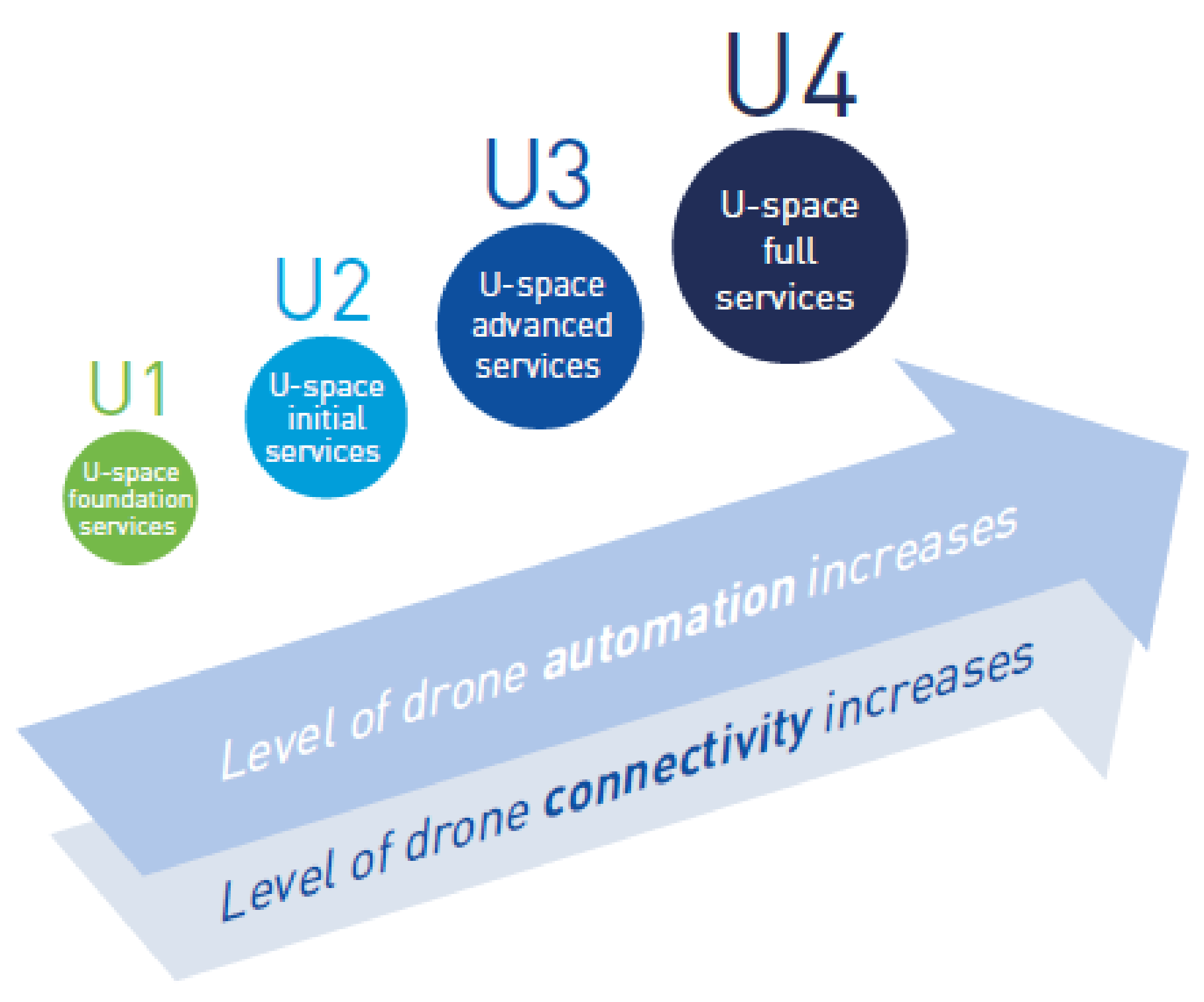
2. Europe’s UTM Framework: ‘U-Space’

U-Space

The demand for drone services is steadily increasing, with the potential to generate significant economic growth and societal benefits [3], as recognised in the 2015 EU Aviation Strategy [4], and more recently in the 2016 SESAR Drones Outlook Study and Warsaw Declaration on drones [1,9]. In order to realise this potential, the Declaration calls for “urgent action on the airspace dimension, in particular the development of the concept of U-space”, which is Europe’s UTM strategy. Ultimately, U-space will enable complex drone operations with a high degree of automation to take place in all types of operational environments, including urban areas. U-space must be flexible enough to encourage innovation, support the development of new businesses and facilitate the overall growth of the European drone services market while properly addressing, at EU level, safety and security issues, respect for the privacy of citizens, and minimisation of the environmental impact. U-space is a set of new services and specific procedures designed to support safe, efficient, and secure access to airspace for large numbers of drones. These services rely on a high level of digitalisation and automation of functions, whether they are on board the drone itself, or are part of the ground-based environment. U-space provides an enabling framework to support routine drone operations, as well as a clear and effective interface to manned aviation, air traffic management (ATM) and air navigation service (ANS) service providers and authorities. U-space is therefore not to be considered as a defined volume of airspace, segregated and designated for the sole use of drones. U-space is capable of ensuring the smooth operation of drones in all operating environments, and in all types of airspace (in particular, but not limited to, very low-level airspace). It addresses the needs to support all types of missions and may concern all drone users and categories of drones [1,2,3,4,5]. EuroDRONE is a demonstration project, funded by SESAR, focused on proving UTM capabilities, challenges, and solutions through experimental UTM testing with real world scenarios presented in [14]. This paper extends the work presented in the 2020 International Conference on Unmanned Aircraft Systems (ICUAS) [14] and provides the extended results on the experimental, technical and regulatory findings of the EuroDRONE project an in-depth view on the practical results and findings achieved. The U-space framework comprises an extensive and scalable range of services relying on agreed EU standards and delivered by service providers. These services do not replicate the function of ATC, as known in ATM, but deliver key services to organise the safe and efficient operation of drones and ensure a proper interface with manned aviation, ATC and relevant authorities. They may include the provision of data, supporting services for drone operators such as flight planning assistance, and more structured services such as tracking or capacity management. Three services have already been identified as “foundation services”: electronic registration (e-registration), electronic identification (e-identification) and geofencing. Current initiatives envisage that electronic registration should be mandatory for drone operators (except operators of drones weighing below 250 g), as well as some classes of drones used in the open category and all drones used in the specific category. Electronic identification will allow authorities to identify a drone flying and link it to information stored in the registry; the identification supports safety and security requirements, as well as law-enforcement procedures. The progressive deployment of U-space is linked to the increasing availability of blocks of services and enabling technologies. Over time, U-space services will evolve as the level of automation of the drone increases and advanced forms of interaction with the environment are enabled (including manned and unmanned aircraft), mainly through digital information and data exchange. The U-space services which relate to various layers and types of services in brief are [1,2,3,4,5]:
U1: U-space foundation services provide e-registration, e-identification and geofencing.
U2: U-space initial services support the management of drone operations and may include flight planning, flight approval, tracking, airspace dynamic information, and procedural interfaces with air traffic control.
U3: U-space advanced services support more complex operations in dense areas and may include capacity management and assistance for conflict detection. Indeed, the availability of automated ‘detect and avoid’ (DAA) functionalities, in addition to more reliable means of communication, will lead to a significant increase in operations in all environments.
U4: U-space full services, particularly services offering integrated interfaces with manned aviation, support the full operational capability of U-space and will rely on very high levels of automation, connectivity and digitalisation for both the drone and the U-space system.

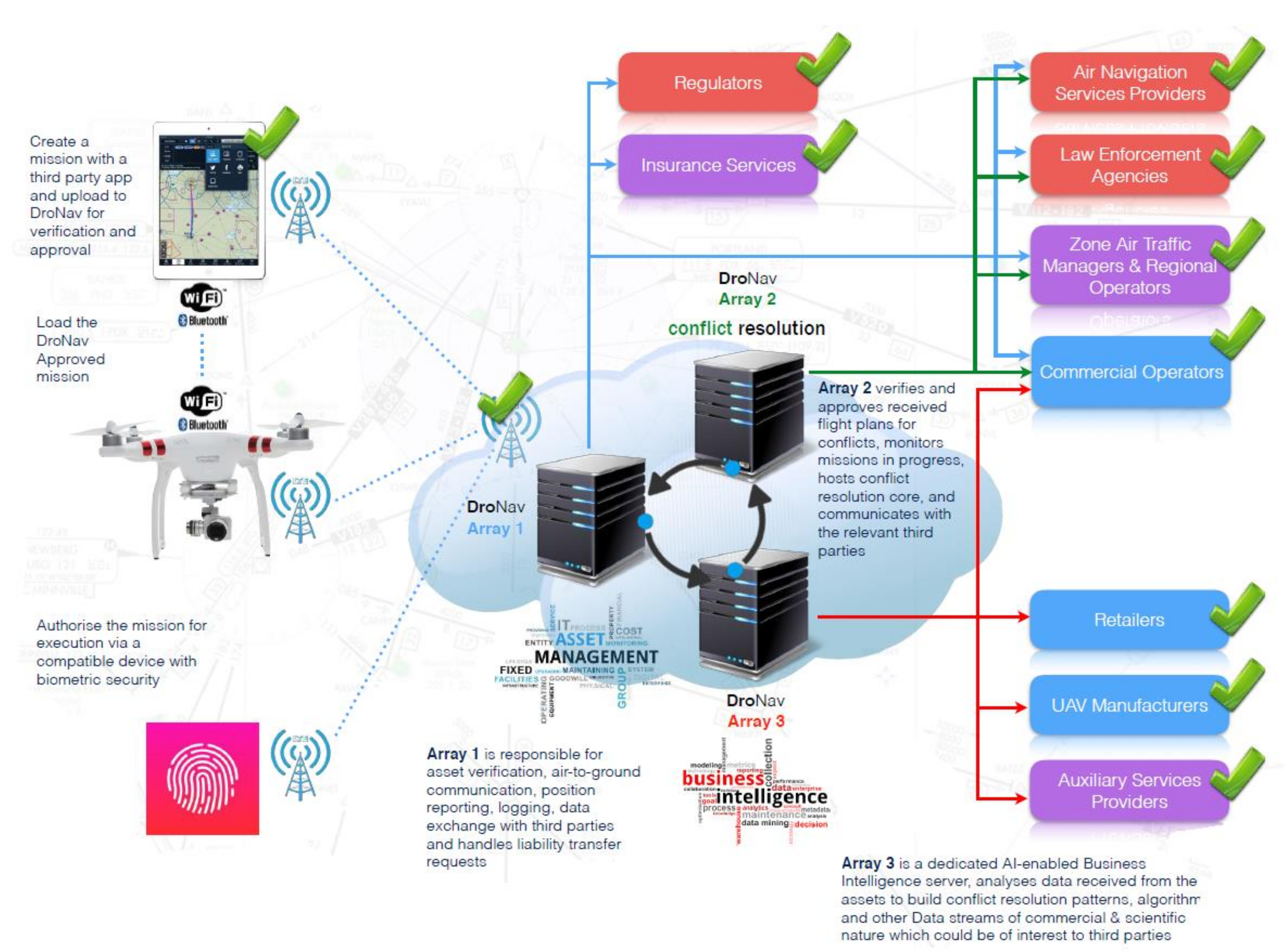
3. EuroDRONE UTM Architecture

EuroDRONE’s architecture is based on the DroNAV UTM system developed by Dronsystems [15]. The key elements of the proposed DroNAV system are: (I) Level 1/U1, Cloud/servers, cellular network, client mobile terminal with software phone/tablet/laptop; (II) Level 2/U2 (additional elements), RF transmitter (onboard), RF receivers connected to the servers; (III) Level 3 (additional elements), highly automated full control of aircraft with Detect and Avoid (onboard). Figure 2 and Figure 3 show different categories of DroNav Level 3, “DronAssistant”; how they interact with General Aviation (cooperative and non-cooperative) and Air Traffic Control (ATC), and how they exchange data and in which direction with DroNav cloud (DronATC), via cellular network or via satellite link. As shown in Figure 4, DronAssistant Category B (thus, with Detect and Avoid, automated conflict resolution and command and control on the fully automated drone) is available and has been tested and will be used in the EuroDRONE demo campaign. Once a mission is submitted to DroNav by the operator, if the proposed mission is accepted by DroNav, the DronAssistant shows through its LEDs if the approved launch window is open, and if the drone is in position (close to the approved take off position with some accepted margin); then the operator can click a button on the DronAssistant, and DroNav, via the cellular network (for Category B), which sends the arm and take off command to the DronAssistant, which executes that command to the autopilot. The internal DronAssistant cellular modem performs V2I communication, one of the two external antennas is for Detect and Avoid (DAA), and the second external antenna is for V2V communication.
Figure 2 shows the essential elements of Level 1, 2, 3 or U-space service levels in EuroDRONE. Figure 3 shows DronNav in action. Figure 3 and Figure 4 show the DroNav core and deployment processes.

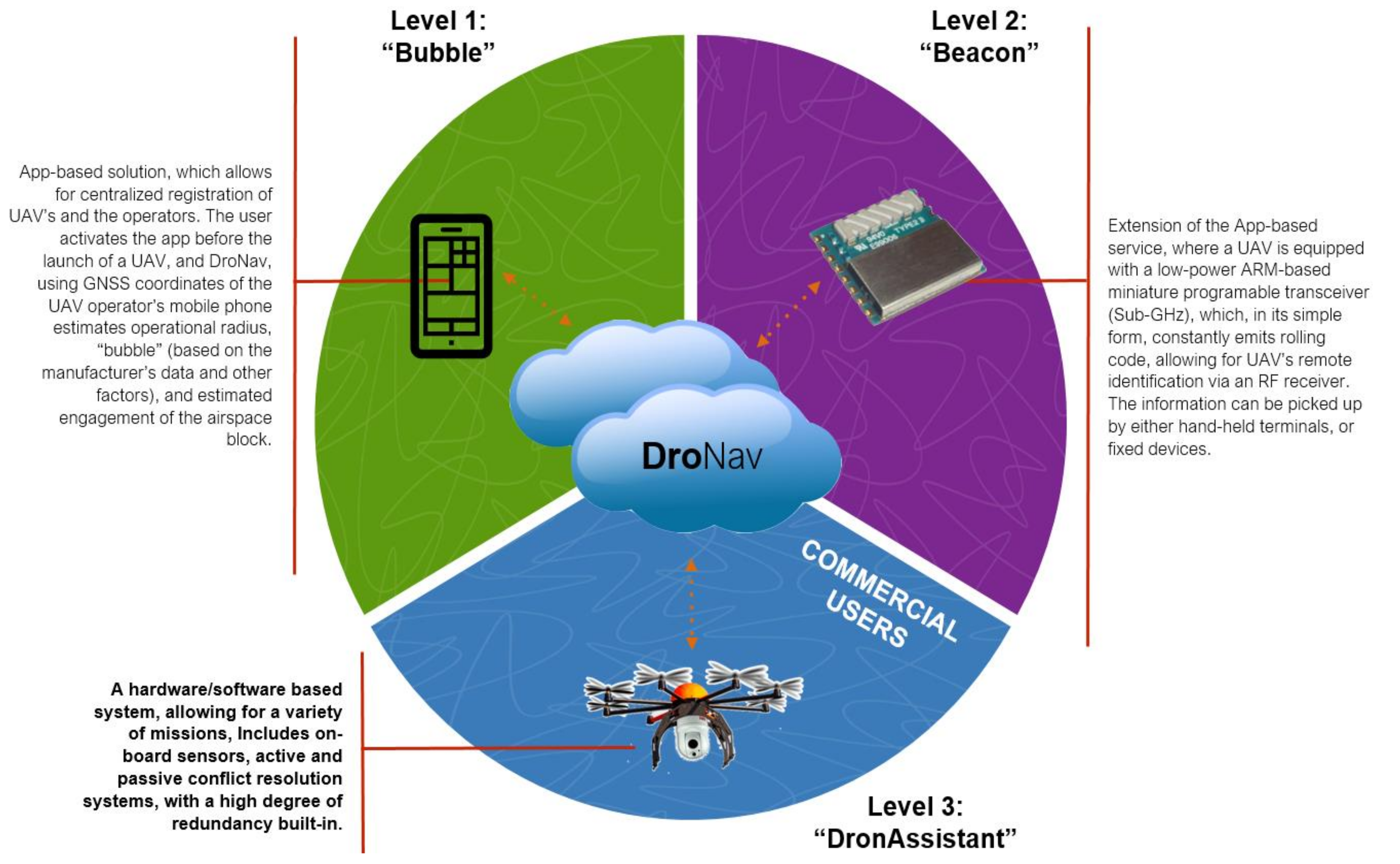
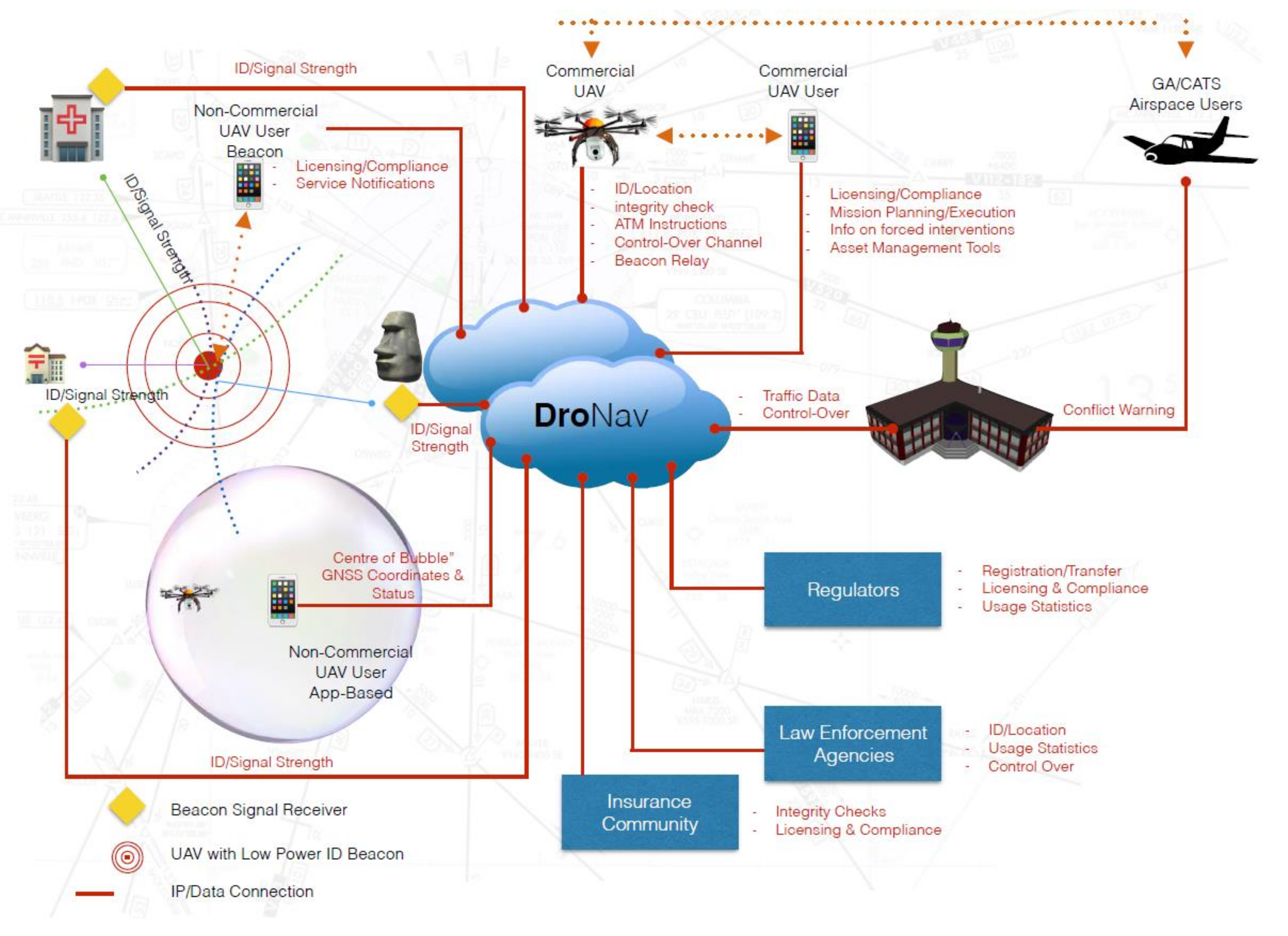
3.1. Vehicle to Infrastructure (V2I)

EuroDRONE uses a novel Vehicle-to-Infrastruture (V2I) system called DronAssistant, developed by Dronsystems [15]. Dronassistant is an end-to-end automated flight management system/mission planning (director) hardware and software system using V2I, V2V over 2.4/5GHz, LTE and sub-GHz communication technology. DronAssistant is used also for Vehicle-to-Vehicle (V2V) communication, thus giving drones the ability to communicate information to each other (among DronAssistants). The hardware also allows use of Detect and Avoid (DAA) solutions, giving drones the ability to detect cooperative conflicting traffic or other hazards, and take the appropriate action to comply with the applicable rules of flight. DronAssistant is also used for real-time tracking via the LTE/4G transponder/mission director system. All these capabilities along with full flight-planning management were demonstrated in the live demonstrations taken place in July and October 2019 in Messolonghi in multiple realistic UTM scenarios. Figure 5 shows the 200-g low-cost (<100€) DronAssistant hardware used in the practical demonstrations where autonomous operations of the system were implemented successfully using cloud-based operations over LTE for multiple and complex scenarios.

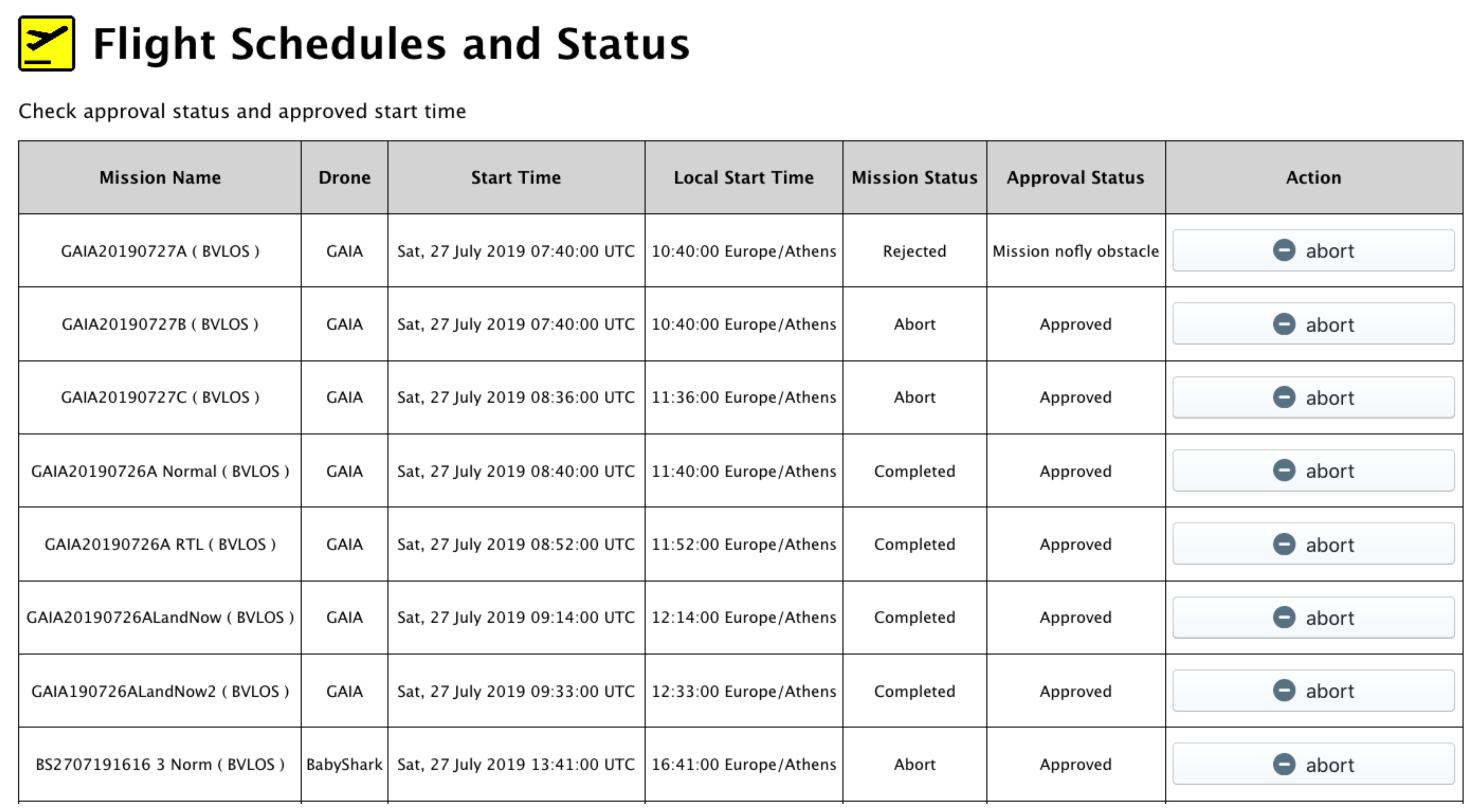
3.2. EuroDRONE Operational Sequence

Important to the U-Space requirements and functionality is the user experience, which is addressed in the EuroDRONE project. In EuroDRONE the operational sequence would be as follows: the operator submits a mission plan, selecting the drone from his/her list of active ones, and declaring the operator position for visual line of sight (VLOS) for Level 1 or for Level 3 services, uploading the flight path that is the output of the drone-specific mission planner used. For both cases, the operator has to indicate the target take-off time, the latest take-off time and the latest end time for the mission. DroNav analyses the proposed mission and performs multiple checks, such as if the prosed mission has conflicts with permanent or temporary NFZs, with buildings, with previously approved missions, or, if the mission uses DronAssistant making use of the cellular network, it is expected to fly in areas where the cellular coverage is expected to be too weak or non-existent. Other checks are performed, such as if the temperature, wind and precipitation are in the range that the manufacturer of the drone declared to be acceptable for that specific drone model, or if that drone and operator are authorized to fly by night, and more. If all checks are positive, DroNav approves the mission, and in the table that summarizes all the submitted missions (Figure 6), it shows the approved take-off time. If the mission is not approved, the reason is explained (Figure 7). Figure 8 shows the visualisation of the none-approved mission.

3.3. EuroDRONE Deconfliction Strategy

Strategic deconfliction of UAV traffic is an important element for highly autonomous and efficient UTM operations. EuroDRONE uses the tool PARTAKE developed in a SESAR funded R&D activity [16,17]. The main objective of PARTAKE is to implement a tool to provide a deep understanding of airspace traffic dynamics by analysing spatio-temporal interdependencies between trajectories and supporting the implementation of a mitigation mechanism that could reduce the probability of air traffic controller tactical interventions while preserving the air space user. Towards this goal, tight interdependencies between aircraft trajectories were identified at the network level and removed by rescheduling take-off times in such a way that take-off times computed by the network manager are preserved within a −5 to +10-min margin. This can be seen as a short-term measure that enables the maintenance of airspace capacity and a reduction in the probability to lose separation minima and lessen the conflict resolution controller’s task loads. Computational efficient identification tools for spatio-temporal analysis of given traffic are implemented in the PARTAKE tool (volume- and traffic-based). To deal with the uncertainty that arises in an operational context with a greater lookahead time, the scope of PARTAKE was aligned with SJU recommendations. Moving towards a more predictable lookahead time, different realistic scenarios have been tested using the London TMA and validated, including exercises with ATCs and pseudo-pilots in the loop.
The strategic deconflicting tool (PARTAKE) maps UAVs missions and analyses and detects potential conflicts (loss of separation minima) with other UAVs, aircraft, or non-flying areas. If a conflict is detected, a mitigation module study is implemented and suggests a departure shift, within a pre-defined interval of time (launch window), assuring the approval of a conflict free mission. The mission is denied when a deadlock is detected (no departure time shift can solve the conflict with other missions already approved). Note that the strategic conflict-resolution service interacts with the mission planning service in two well-defined time instants. Figure 9 illustrates this process: a given time before the execution of the mission (mission submission time), the mission planner submits the mission to be performed. It can be composed of an area description or coordinates together with its time interval or timestamps (4D description). Moreover, it also specifies a time interval (launch window), together with a requested time in which the mission will start. The PARTAKE service checks if there is any conflict with other missions or areas, and if it is the case, it verifies if it is possible to ensure a conflict-free mission by shifting the departure time inside the launch window interval of all the missions not confirmed already. Priorities can be assigned to certain mission types or UAVs (hospital emergency, drones for police activities…) giving them advantages when they are in conflict with other missions and need to be mitigated. If the mission does not have any conflict or it is possible to solve it with a departure shift, the mission is accepted. If there is a deadlock, the mission is denied (see Figure 9A). At a certain time before the start of the mission (confirmation time, see Figure 9B), PARTAKE assigns and notifies the airspace user of the take-off time assigned inside the mission launch window.
An initial feasibility study was conducted for the U3 tactical de-confliction service and DAA capability. Cooperative intruders and multiple no-fly-zones have been considered for tactical de-confliction. To successfully support the tactical de-confliction service, the DAA capability consists of detecting vehicles in airspace, identifying potential conflicts, and performing manoeuvres to resolve the conflict, guaranteeing the minimum separation from vehicle/no-fly-zones. The detecting device, FLARM, is known to provide the relative range and velocity of cooperative intruders. Using FLARM and no-fly-zone data in DronAssistant, a collision avoidance (CA) algorithm has been designed to identify and resolve potential conflicts. The algorithm utilises a differential geometry concept (DGC), which enables the system to analytically guarantee the minimum separation with low computational cost. Furthermore, this concept improves efficiency, reducing the deviation from the original flight plan. The safety and efficiency of the developed CA algorithm have been validated both analytically and numerically.
EuroDRONE uses the PARTAKE tool integrated with DroNAV in order to simulate end-to-end UTM operations with practical demonstrations (UAV flights) which is described in Section 4.

3.4. Sense and Avoid Approach

As discussed, there is an increasing interest in the versatile applicability of Unmanned Aerial Vehicles (UAVs), which makes the development of robust Unmanned Traffic Management (UTM) framework paramount. U Space in Europe is coactively developing a UTM solution that enables the end users to operate their UAVs with sufficient efficiency and safety. Even though UTM shares some similar services with manned Air Traffic Management (ATM), which is relatively well-established through the past decades, UTM has its distinctive characteristics in the key services such as strategic and tactical deconfliction. The algorithms developed for ATM may not guarantee safety and efficiency for UTM, due to their discrepancy in its scale, platform, and non-segregated operational airspace. One of the most important services to be further developed and validated for UTM is collision avoidance algorithms, which guide each UAV to ensure a safe distance from vehicles and no-fly-zones in the inflight stage. There have been several approaches proposed for UAV collision avoidance which are detailed in [17], such as: rule-based approaches, geometry-based approaches, artificial potential field algorithms, and numerical optimization methods. Rule-based approaches are easy to implement, but require different rules depending on the platforms and scenarios. Artificial potential field methods are also easy to implement, but may suffer from the so-called narrow channel problem. This occurs when the obstacles are dense enough such that the minimum separation is not guaranteed near the local minima. Numerical optimization methods can guarantee the minimum separation as well as optimizing energy or time, but the computational load is higher than the rule-based or artificial potential field methods.
The aforementioned collision avoidance methods have their own advantages and characteristics, but most of them are developed under the assumption that the obstacles have circular or elliptical shapes. This assumption may not be practical nor efficient, considering that no-fly-zones are usually large in scale and declared as 4D polygons. Approximating a large zone as a cylindrical shape can lead to unnecessary deviation from the original flight plan, raising the risk to the battery level. In urban environments, there could even be no feasible path among the dense buildings that are approximated as cylindrical shapes. Hence, the consideration of irregularly shaped obstacles in tactical deconfliction is a key element of a UTM solution expanding the operational boundary to challenging environments.
EuroDRONE uses a geometry-based collision avoidance algorithm which can consider the practical issue of multiple irregularly shaped obstacles, which is detailed in [17]. The proposed algorithm, developed for a multitude of UTM generic scenarios, guarantees the minimum separation not only with moving intruders, but also with polygonal no-fly zones or buildings. The differential geometry concept [17] is utilized to analytically guarantee the minimum separation with low computational costs. The key idea of the algorithm is to detect the line-of-sights with potential conflict, and to change the heading angle to avoid the conflict. Various performance measures such as the minimum separation, flight time to reach the waypoint, and computational cost are compared with other collision avoidance methods to verify the safety, efficiency, and scalability of the algorithm, respectively. Details of the algorithms and their mathematical formulation are available in [18].
Numerical simulations are conducted to validate the performance of the proposed collision avoidance algorithm. Three obstacles are modelled from the no-fly-zones and buildings near the test site, Messolonghi Airport in Greece, but the distance between the obstacles is adjusted to create a more challenging and denser environment. The velocity of both the UAV (V) and the intruder (Vin) is 14 m/s, and the minimum separation R0 is 50 m. A hundred different scenarios are created near the obstacles, with different start and end points for both the UAV and the intruder. The trajectories of the intruder are derived from the proposed collision avoidance algorithm based on the differential geometry concept (DGC). To better assess the safety and efficiency of the proposed collision avoidance algorithm, two commonly used collision avoidance algorithms are used for comparison: the artificial potential field method (APF), and particle swarm optimization method (PSO).
Some important simulation results are shown in Figure 10. The 100-scenario simulations have been conducted with no-fly zones in Messolonghi airport, but with adjustments of their distance to test more challenging environments for Detect and Avoid (DAA). The trajectory of the developed collision avoidance algorithm, DGC, is shown in (a), compared with other common collision avoidance algorithms, artificial potential field (APF) and particle swarm optimisation (PSO) methods. It is shown that the DGC algorithm proposed and used in EuroDRONE guarantees the minimum separation with fast recovery to the original flight plan’s waypoint. Expanding the number of scenarios to 100 with different trajectories as in (b), the minimum distance and total flight time are analysed in (c) and (d). The proposed CA algorithm guarantees the minimum distance and manoeuvres efficiently to reduce the total flight time, compared with other algorithms APF and PSO (note that PSO shows the best efficiency, but its computational cost is more than 1000 times that of DGC.) Although the CA algorithm analytically and numerically guarantees safety, the DAA capability should be further validated with low-cost sensors in future UTM demonstrations.

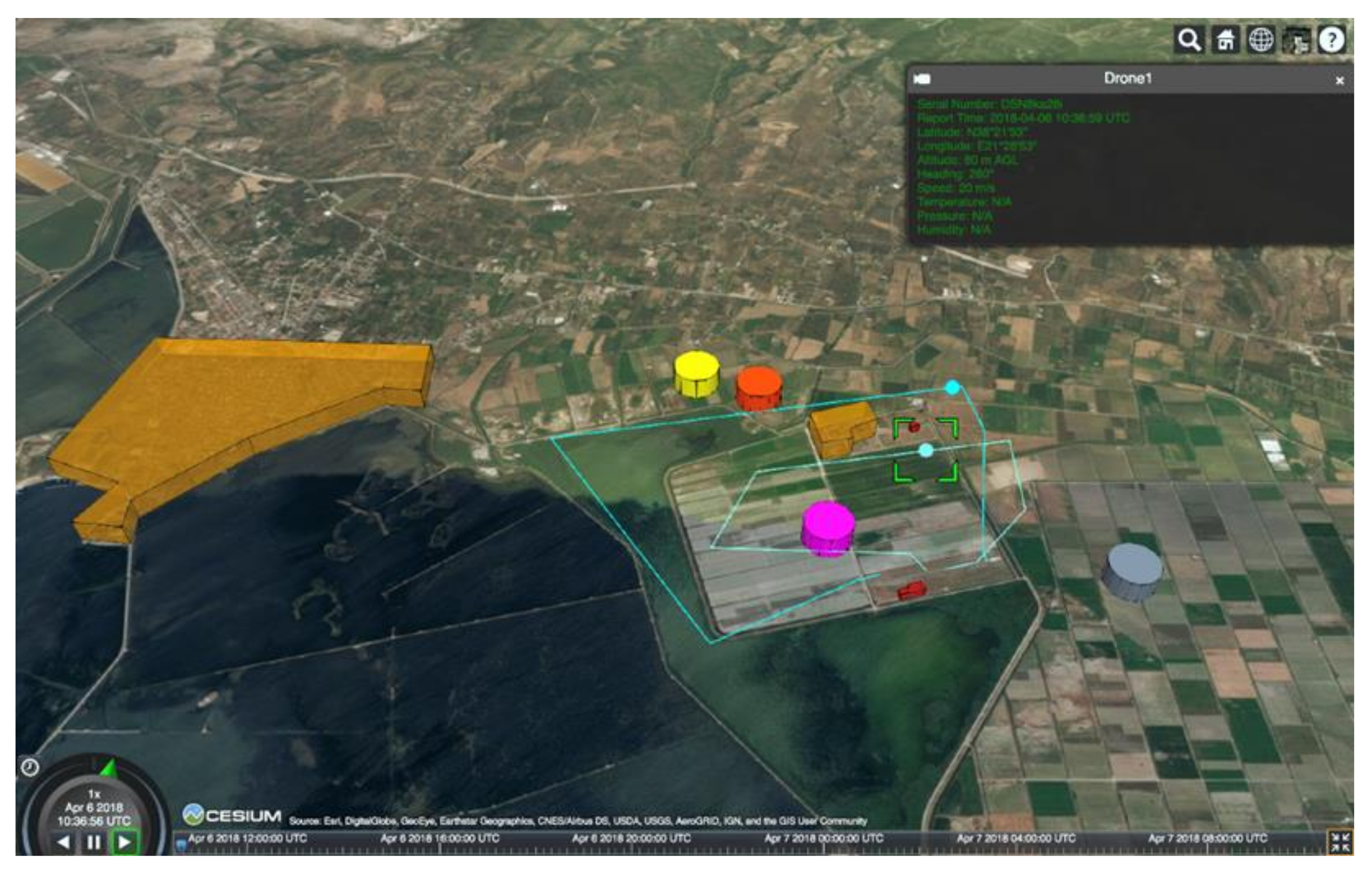
4. EuroDRONE Flight Trials

Central to EuroDRONE’s objectives is the validation of UTM technologies and services through a realistic, practical demonstration of drones operating in an urban environment. Two demonstrations took place in the airport of Messolonghi in July and October 2019 involving various UTM scenarios:
  • Scenario 1, simple, all over Messolonghi airport, some drones in VLOS in cylinder (can be multiples, but for some of them we just submit cylinder; we can report positions via DronAssistant), some drones in BVLOS but flying around the airport only (DronAssistant); this scenario is for surveying, monitoring, taking images and videos in general;
  • Scenario 2, over Messolonghi, show Detect and Avoid, with BVLOS and DroNav (at least 2) plus as many VLOS as in the first scenario; this scenario is for surveying, monitoring, taking images and videos in general;
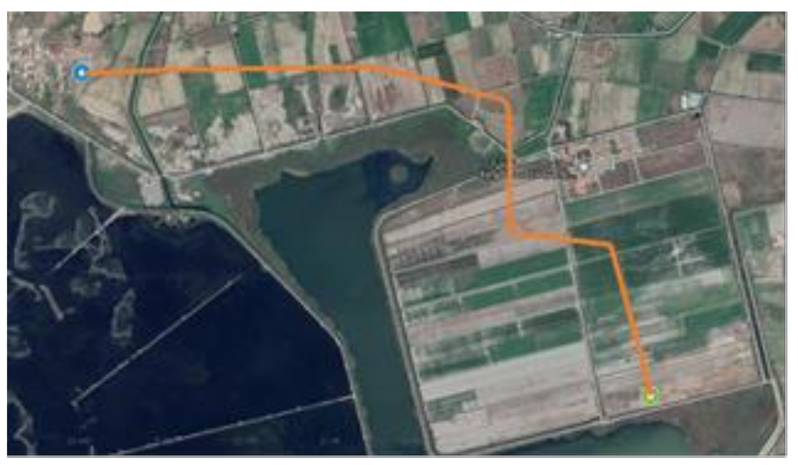
  • Scenario 3, from Messolonghi city to Messolonghi airport, can be as the two previous, but we add a VTOL drone from ELTA post office in the city to landing on the airport; show B2B small-parcel express logistics (e.g., Figure 11);

4.1. Demonstration Objectives

As described, multiple demonstrations were put together by EuroDRONE in order to validate UTM technologies and services, including the following objectives and constraints (according to USpace level services):
  • The demonstration occurred in a real-life environment, using actual, non-segregated airspace.
  • Demonstrations included both types of operations BVLOS and VLOS.
  • The drones used for the demonstrations were fully automated, mixed with manually operated drones in VLOS.
  • The demonstration included U1 services and assessed their compatibility with U2 services.
  • Demonstrations included at least U-space U2 core services and associated drone capabilities.
  • Demonstrations included realistic missions corresponding to anticipated business opportunities.
  • Demonstrations included at least five drones operating simultaneously in the same geographical area.
  • Demonstrations of some U-space enhanced services (U3) (through the DronAssistant).
  • Drone operations in controlled airspace especially close to airports (including airspace design and procedural interface with ATC).
  • Inclusion of operations performed by sport aviation/general aviation or rotorcraft in the flying demonstration(s).
  • Inclusion of leisure drone user(s) in demonstration activities to show that the general public can pursue their hobbies in this shared environment and benefit from some of the U- space services.
  • Use of Vehicle-to-Infrastructure communication (V2I) communication as the ability for drones to share information with infrastructure components (through DronAssistant).
  • Use of Vehicle-to-Vehicle (V2V) communication as the ability for drones to communicate information to each other (among DronAssistants).
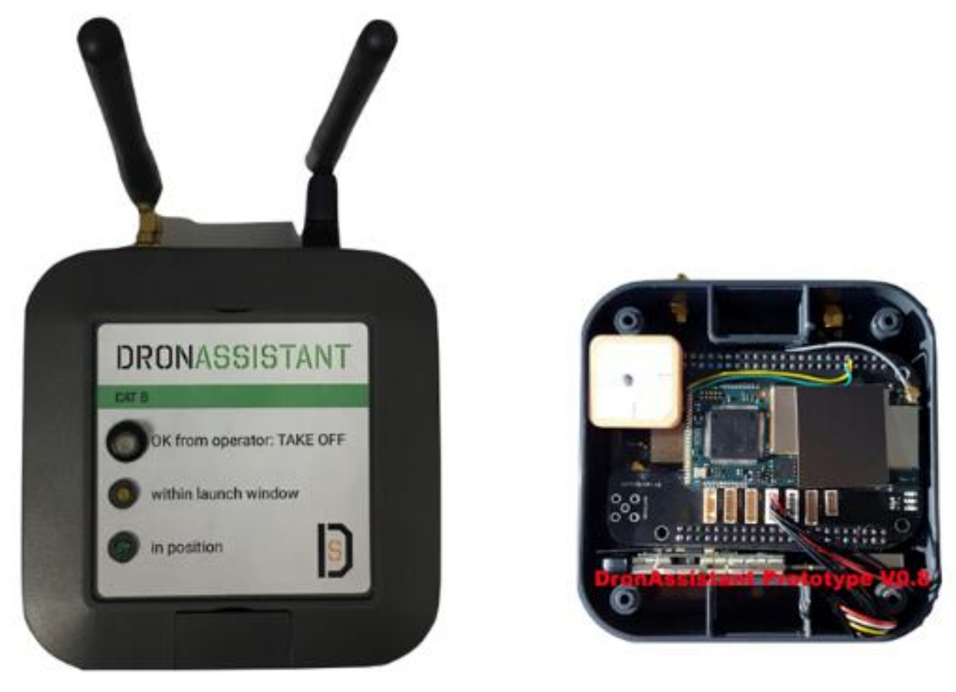
  • Use of Detect and Avoid (DAA) solution, as the ability for drones to detect cooperative conflicting traffic, or other hazards, and take the appropriate action to comply with the applicable rules of flight (DronAssistant Category B).
The following sections detail the process and results from the EuroDRONE demonstrations that took place in July and October 2019.

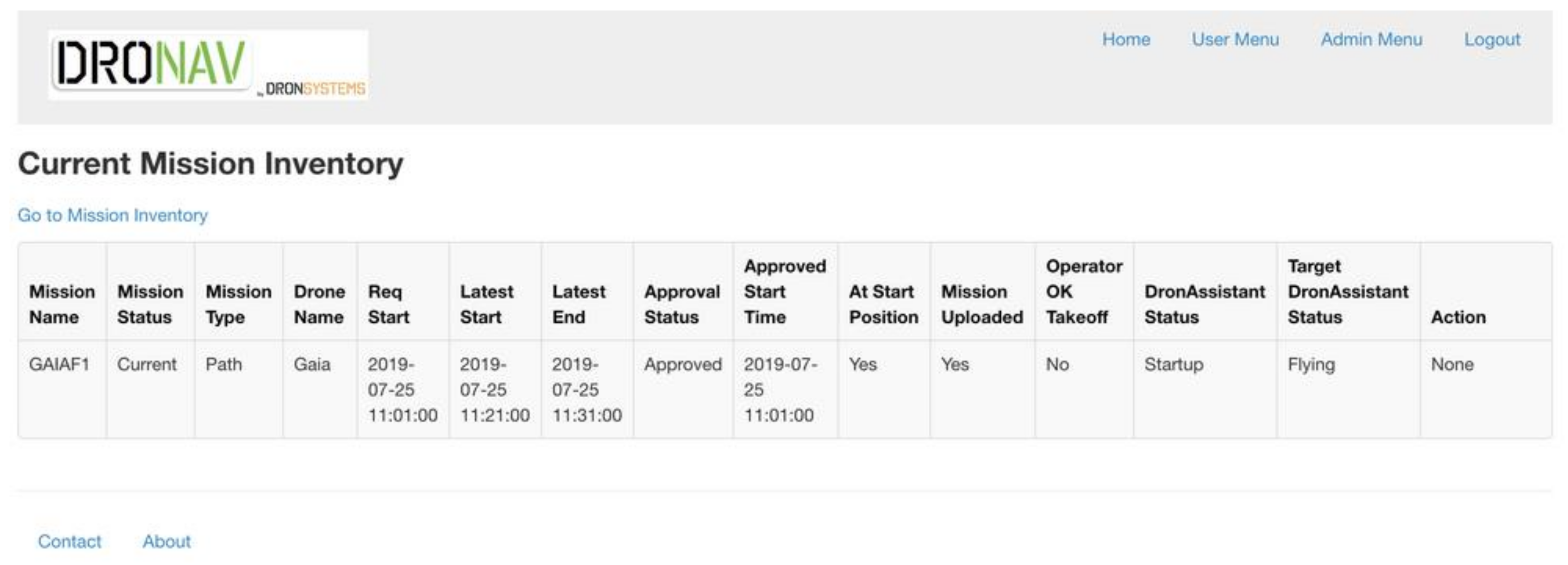
4.2. Demonstration No. 1

During EuroDRONE flight tests in July, the main goal of the demonstration was to prepare, integrate and finalize the software to conduct real flights and test the drones (see Figure 12, flight duration, speed limit, etc.), and to perform flight tests that were planned in a real-life environment using actual non-segregated airspace. Requirements and any other issues that might have been important to perform both types of operations, BVLOS and VLOS, were recorded. Initial flights were conducted in the broader area of the airport, where the mission (the waypoints list) was uploaded to the Dronav. The waypoint list contains information about the GPS coordinates (latitude, longitude, altitude) as well as the speed at which the drone proceeds to each waypoint. When the mission is uploaded, Dronav processes the mission to ensure that it satisfies certain criteria, such as weather conditions, collisions based on PARTAKE, home position, etc., and decides whether to approve the mission. In the case that the mission is approved, the Dronav creates cloud points in the area of the mission to able to segregate any area where there might be an obstacle in the future. After this procedure, the mission is transmitted from Dronav to the DronAssistant connected to the drone and the DronAssistant transmits the mission through serial connection to the autopilot, which executes the mission by giving every waypoint individually until the list is empty. During this period, an authorized pilot was always present with a remote controller, and, in any case, he was able to take manual control of the drone. If the take-off position and the home position differ above a certain threshold, the mission is also rejected. The last step contains the PARTAKE solution to avoid collisions, where the decision is made based on PARTAKE.
The step-by-step description of the Demo 1 scenario No. 1 (Figure 13 and Figure 14):
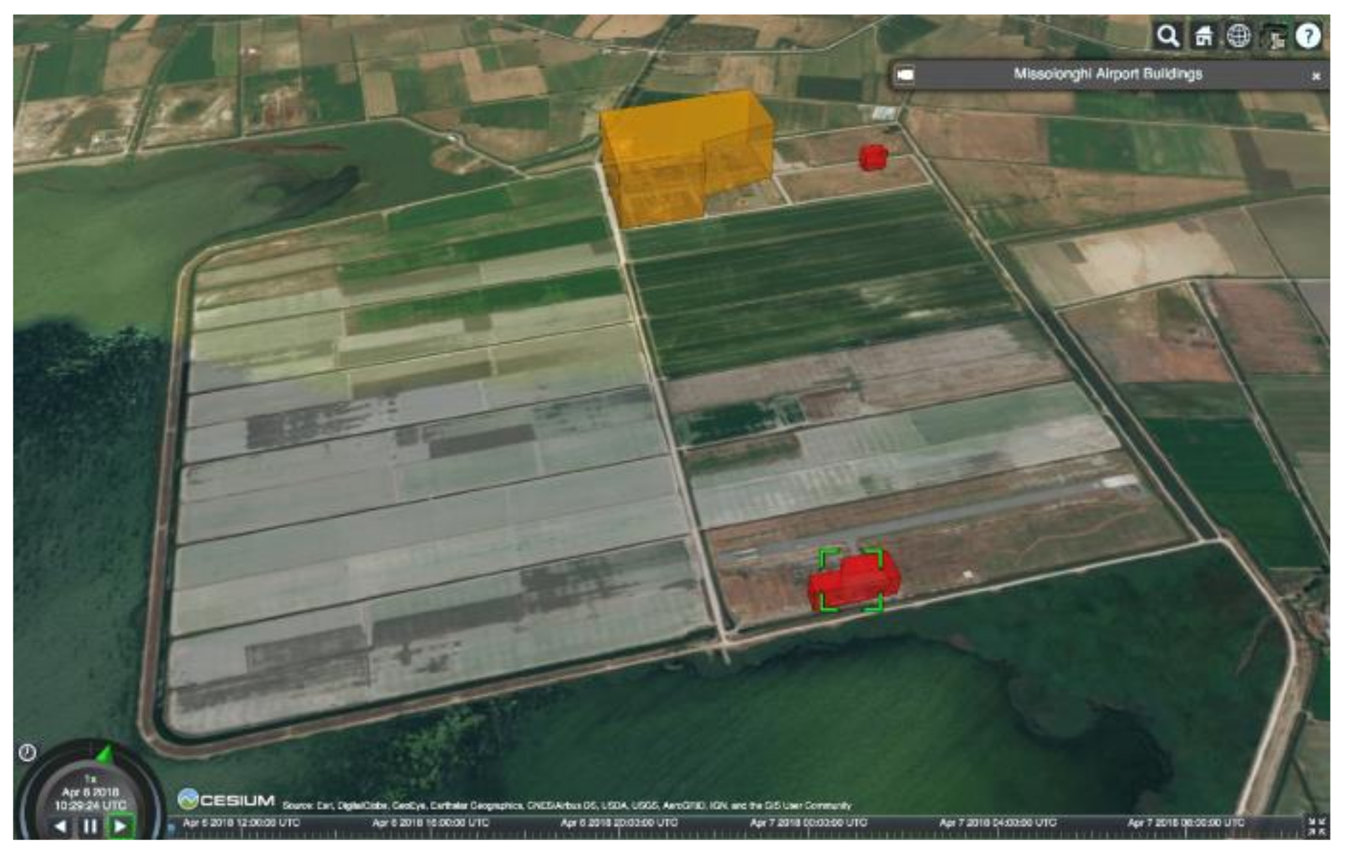
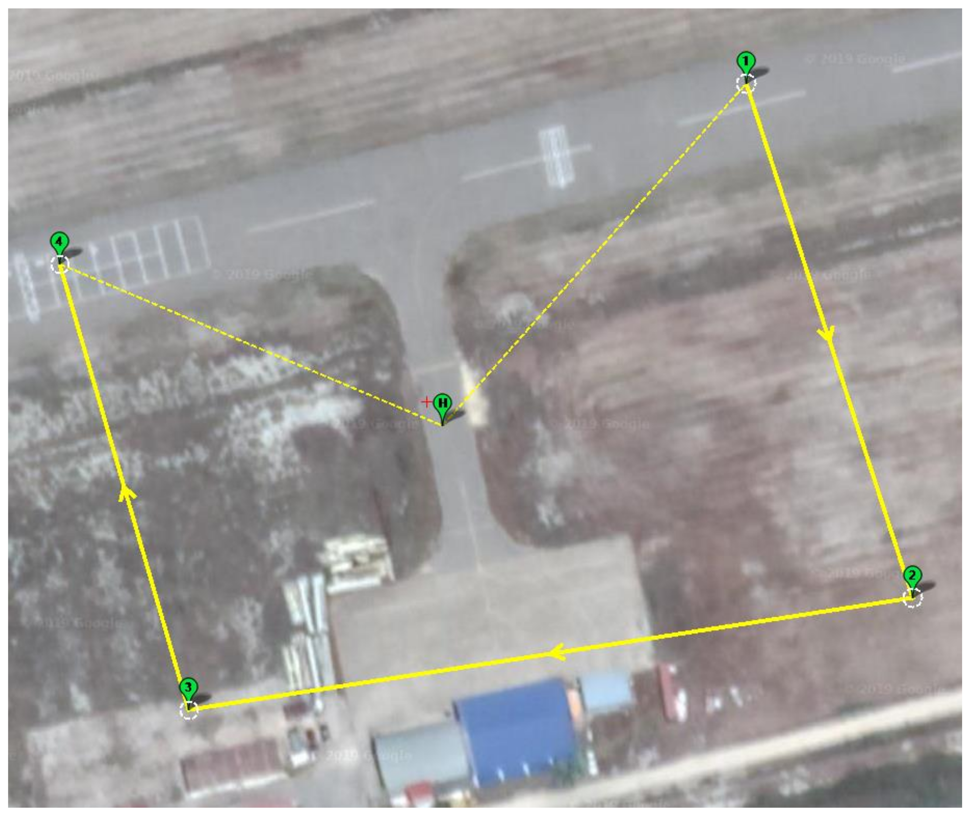
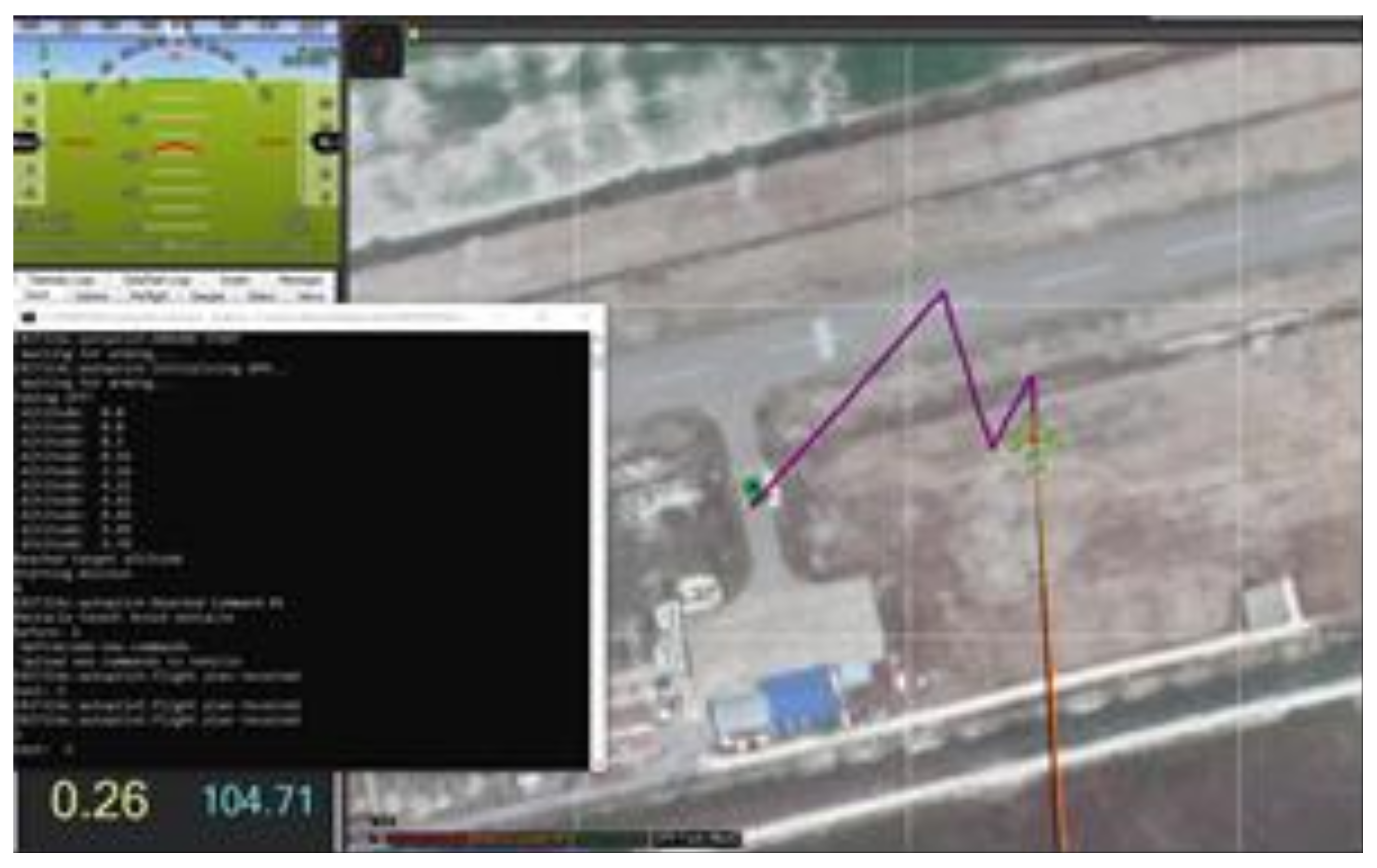
  • A mission was created for a flight in the area of Messolonghi airport, in standard ArduPilot text format. The path was surveyed for any obstacles.
  • Gaia was transported to the take-off position and pre-flight tests were conducted.
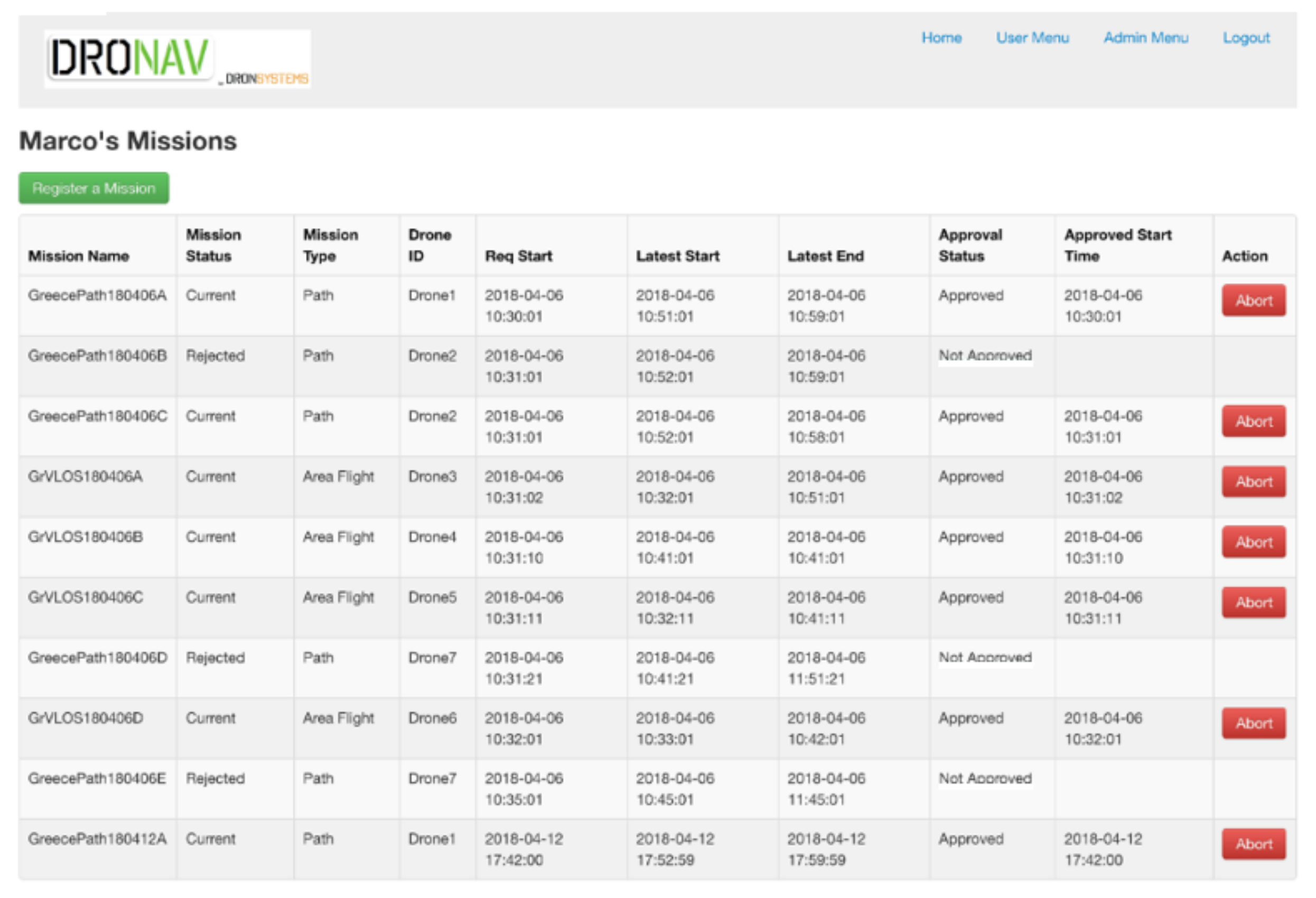
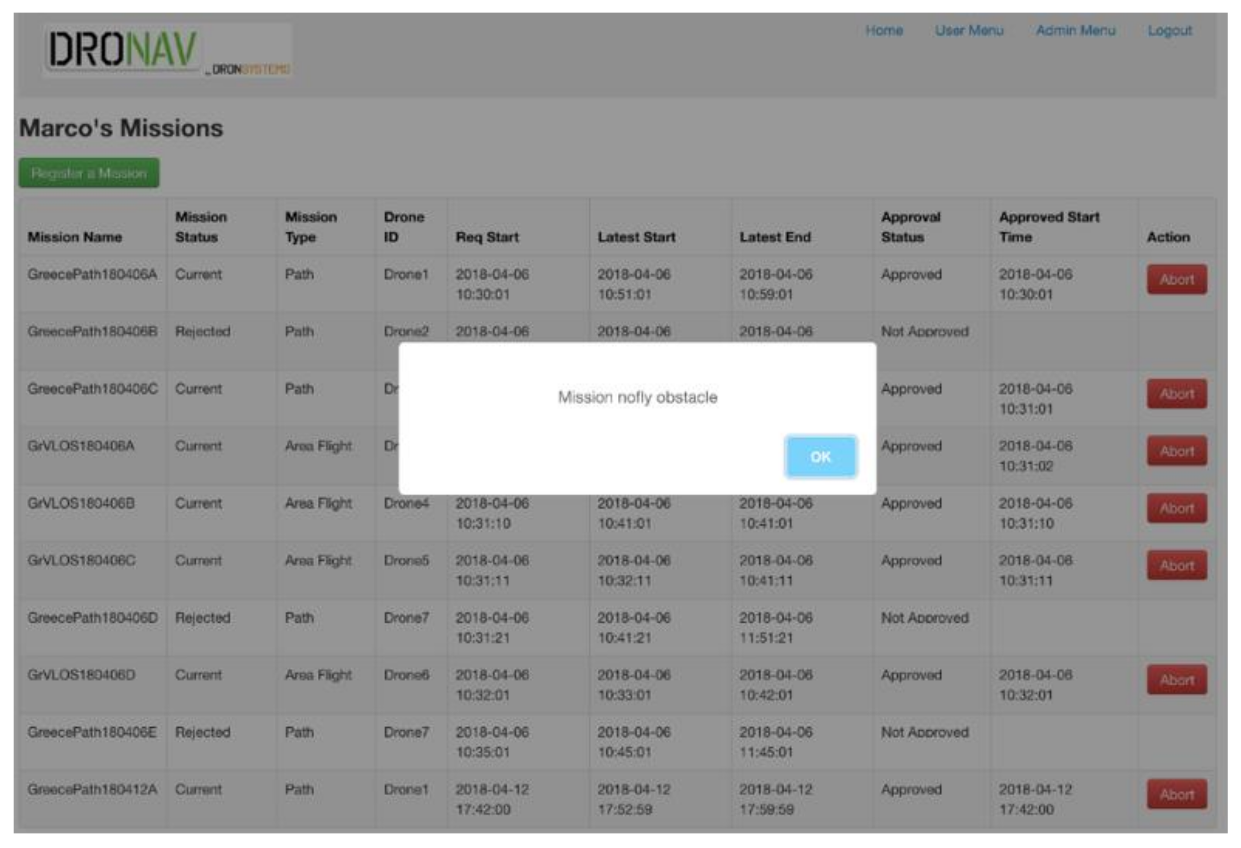
  • The mission was uploaded to the DroNav platform, which tested for any conflicts.
  • After approval, the mission was automatically uploaded to the UAV from DroNav through DA, when the flight time slot was reached.
  • The area (Messolonghi Airport) was notified that the flight was about to begin.
  • The operator of the UAV pressed the take-off button on the DA and, 15 s later, the flight began carrying out the uploaded mission.
  • The UAV reported through the DA during the entire flight at 1 sec intervals.
  • After the landing of the UAV, the area (Messolonghi Airport) was notified that the flight was concluded.
Following successful demonstration of the above scenario (no. 1), the next step was to set up five drones flying in the area of Messolonghi Airport. The drones were the Gaia, Babyshark, and three small quadrotors (one equipped with DA). The scenario demonstrated the successful flight of multiple UAVs in VLOS mode.
The second scenario in Demo 1 involved flying around the airport with an intruder and a mix of manually operated VLOS flights with highly automated BVLOS missions. VLOS and BVLOS operations are designed for different needs, both recreational and commercial. An intruder UAV enters the operating area and should be identified and avoided. The operating method included flight plans which were submitted for approval to DroNav, acting as a centralised system (which takes sensor readings from vehicles to recognise intent). Some were for manual operation requesting the formation of a geofence, whereas the ones corresponding to automated missions did not pose such a restriction. As each flight plan was submitted, pre-tactical deconfliction was carried out, resulting in the acceptance of said flight plan or its outright rejection. Each operator will then proceed to realize his flight. In this scenario the aim was to test the Detect and Avoid system in simulations.
The UAV is located in the home position (Figure 15, denoted with H) and has to visit the waypoints 1,2,3 and 4 (in that order) and then return to home position. We assumed that the intruder is located between waypoints 1 and 2, at a certain height and is stationery. As we know, the FLARM provides information about the distance and the angle between the drone and the intruder, so we based our simulation on the following. We parse the txt file which contains the waypoints to a data structure, and we provide this data structure to the autopilot in AUTO mode to execute the mission by indicating that the first element in the data structure is the first waypoint. Then, every time we read the GPS measurements, we calculate the distance between the drone and the intruder (due to the fact that we know the fixed position of the intruder). If the distance is below 5 m, we command the drone to stop executing this mission by creating and uploading a new one that moves the drone to a safe area.
The last waypoint that the drone was heading to was indexed; before it receives a report for collision and when the drone reaches a safe area (no collision danger) a new mission (a copy of the original mission) is created and uploaded with the difference that the first waypoint is the last waypoint that the drone was heading to before the collision. In this way, with this scenario it is possible to test and check that an early stage of the Detect and Avoid system is working (Figure 16).
As can be seen in Figure 17, the trajectory that the drone followed is depicted in purple colour. If one compares it with the trajectory of the original mission (Figure 16) it is possible to see that the drone, while executing the mission, detects an obstacle and, at a threshold of a five-meter distance, the drone is forced to turn to the left to avoid the collision. When it was in a collision-free state, the drone executed its mission as it was initially scheduled. The actual Detect and Avoid service is based on the FLARM hardware, where drones that are equipped with this hardware can communicate. Through this communication, FLARM provides estimation about the distance, the angle, and velocity of the most dangerous or possible collision. The Detect and Avoid algorithm based on the distance and the angle estimation that FLARM provides creates new waypoints, to avoid a collision with another vehicle, towards a safe area based on some criteria and heuristics, and when the drone is safe, it will continue to execute the initial mission and continue to its last waypoint. To test the Detect and Avoid system, a simulation environment was initially created of DAs equipped with FLARM technology in order to test the communication between them and the corresponding messages that FLARM provides when it detects another vehicle. In this simulation, we have set the location of the intruder to be static, as in the previous example, and the agent was executing the same mission as in the previous example. The entire Detect and Avoid System was tested in simulations, using a simulated DA equipped with FLARM and the drone-kit simulation to manipulate the drones. As the drones were executing their missions, at some point, the FLARM provided an alert that the distance between them was under a certain threshold. Therefore, to avoid the collision, their mission is placed on hold and a new waypoint list is created to be executed to move the drones to a collision-free position. When the alert provided by FLARM is over, the drones will execute their actual mission, from the point they were before the alert.
Figure 18 shows further testing conducted using a mix of fixed-wing (BabyShark), rotorcraft (GAIA, Trebicolo) UAVs for multiple mission scenarios in the Demo 1 test campaign, which were completed successfully.
Figure 19 shows a summary of the tests conducted with the timings, different UAV platforms and approval process based on the mission criteria set.
In the first Demonstration/trial the actions, achievements and milestones were:
  • Testing the network coverage in the demonstrations area
  • Manual flight of each individual drone for security reasons
  • Manual take-offs and landings for testing
  • Autonomous VLOS operations in the vicinity of the airport of Messolonghi
  • Continuous trajectory tracking
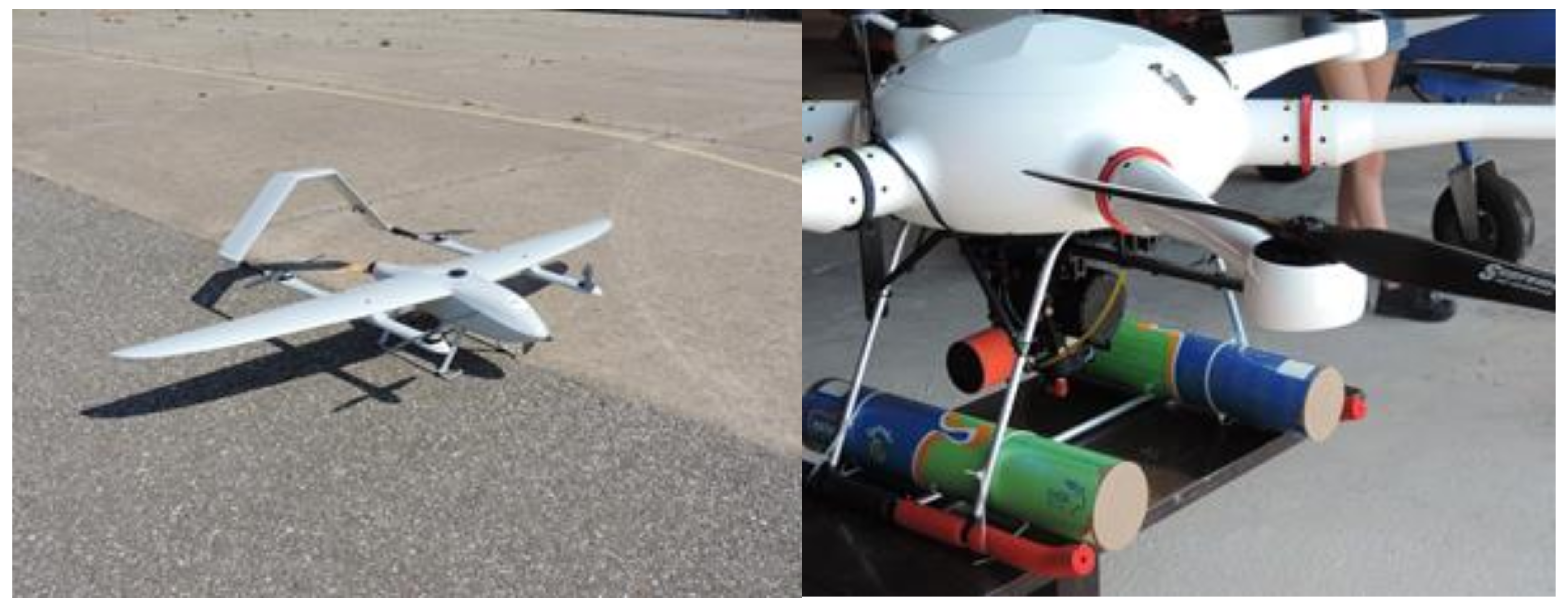
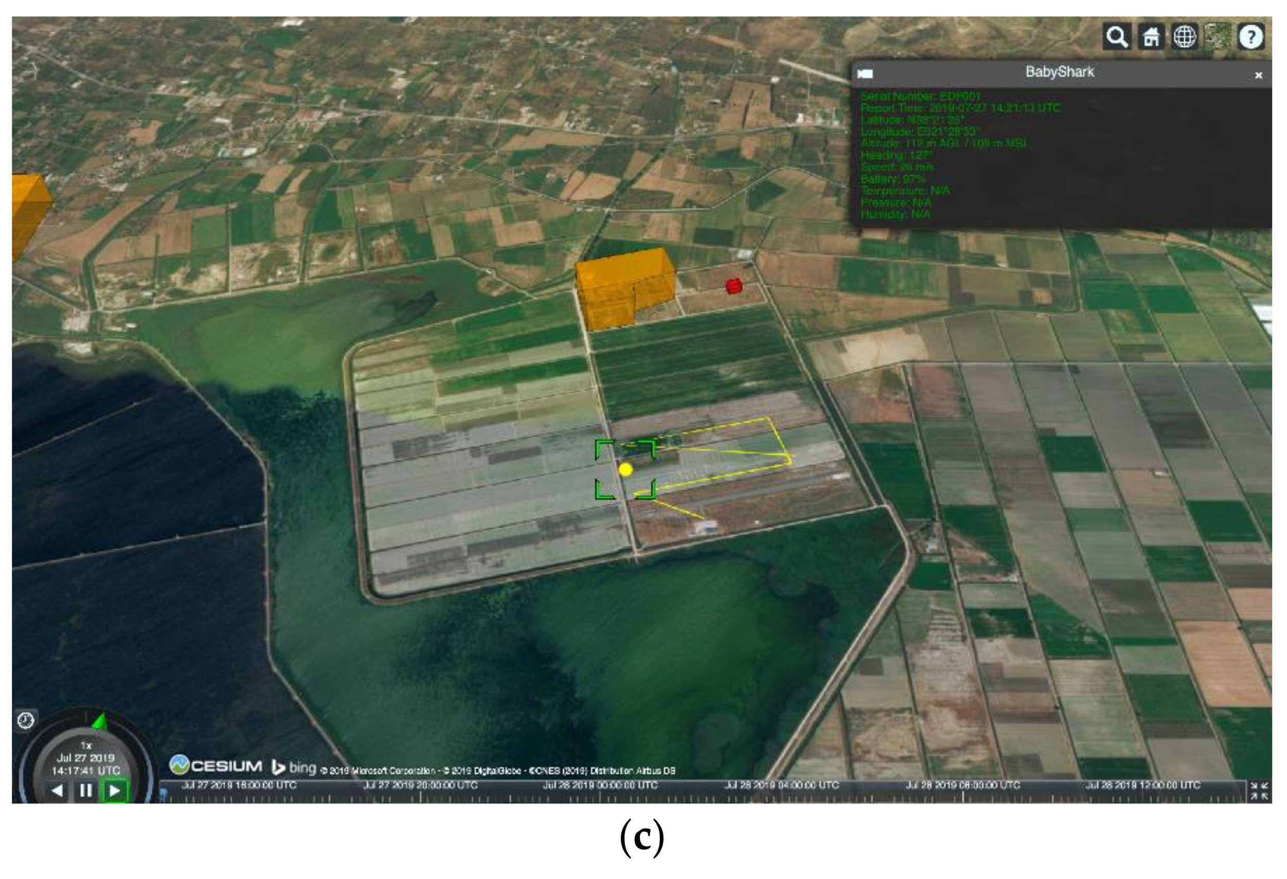
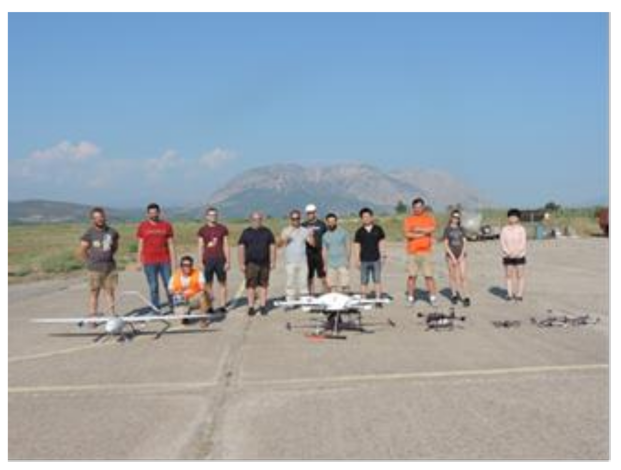
  • Use of both a hexacopter (GAIA) and a VTOL (Babyshark) UAV Successful mission of delivering the attached load for the VLOS operation
  • FLARM technologies were tested along with V2V communication and collision avoidance capabilities.
  • Flights to test the endurance of the UAVs
  • Collision avoidance was tested in simulation scenarios using FLARM simulation
In summary, the objectives of the first demonstration for EuroDRONE were met almost in full, with BVLOS flights being the next goal to achieve for Demonstration No. 2.

4.3. Demonstration No. 2

As in the first demonstration that took place in July 2019, the purpose of the Demonstration No. 2 campaign was to test the operational acceptability of U-space services and to demonstrate the operational acceptability, i.e., the impact of roles, tasks, and procedures under U-space services (U1, U2) and their feasibility. In addition, we intended to demonstrate the operational validation of U-space enhanced services (U3) (through the DronAssistant) and the operational feasibility and acceptability, i.e., the impact of roles, tasks and procedures under U-space services (initial U3) on end-users under nominal, non-nominal and degraded conditions, as well as various flight rules (VLOS, BVLOS, coastal, urban, suburban, populated environment, vicinity to airports and autonomously).
Initial flights were conducted in the broader area of the airport, where the mission (the waypoints list) was uploaded to the Dronav. The waypoint list included information about the GPS coordinates (latitude, longitude, altitude) and also the speed at which the drone proceeds to each waypoint. Once the mission is uploaded, Dronav processes the mission to ensure that it satisfies certain criteria, such as weather conditions, collisions based on PARTAKE, etc., and provides permission or not to fly. In the case that the mission is approved, it creates cloud points in the area of the mission to able to segregate any area where there might be an obstacle in the future. After this procedure, the mission is transmitted from Dronav to the DronAssistant connected to the drone, the DronAssistant transmits the waypoints list through serial connection to the autopilot, which executes the mission by giving every waypoint individually until the list is empty. A pilot was always present with a remote controller and in any case, he was able to take manual control of the drone. Regarding the BVLOS flight, a pilot was in the take-off area to power up the drone and to provide reassurance by his presence; another pilot was at the landing position for the same purposes. During the BVLOS flight, the drone was recording through its camera and the video was transmitted to the ground control station located in Messolonghi Airport (Figure 20).
The main steps were:
  • Coordination with ATC
  • Continuous flight status monitoring through Dronav platform (with RF visual monitoring for backup)
Figure 20. The flight path of the BVLOS mission/Demo 2.
Drones 06 00053 g020
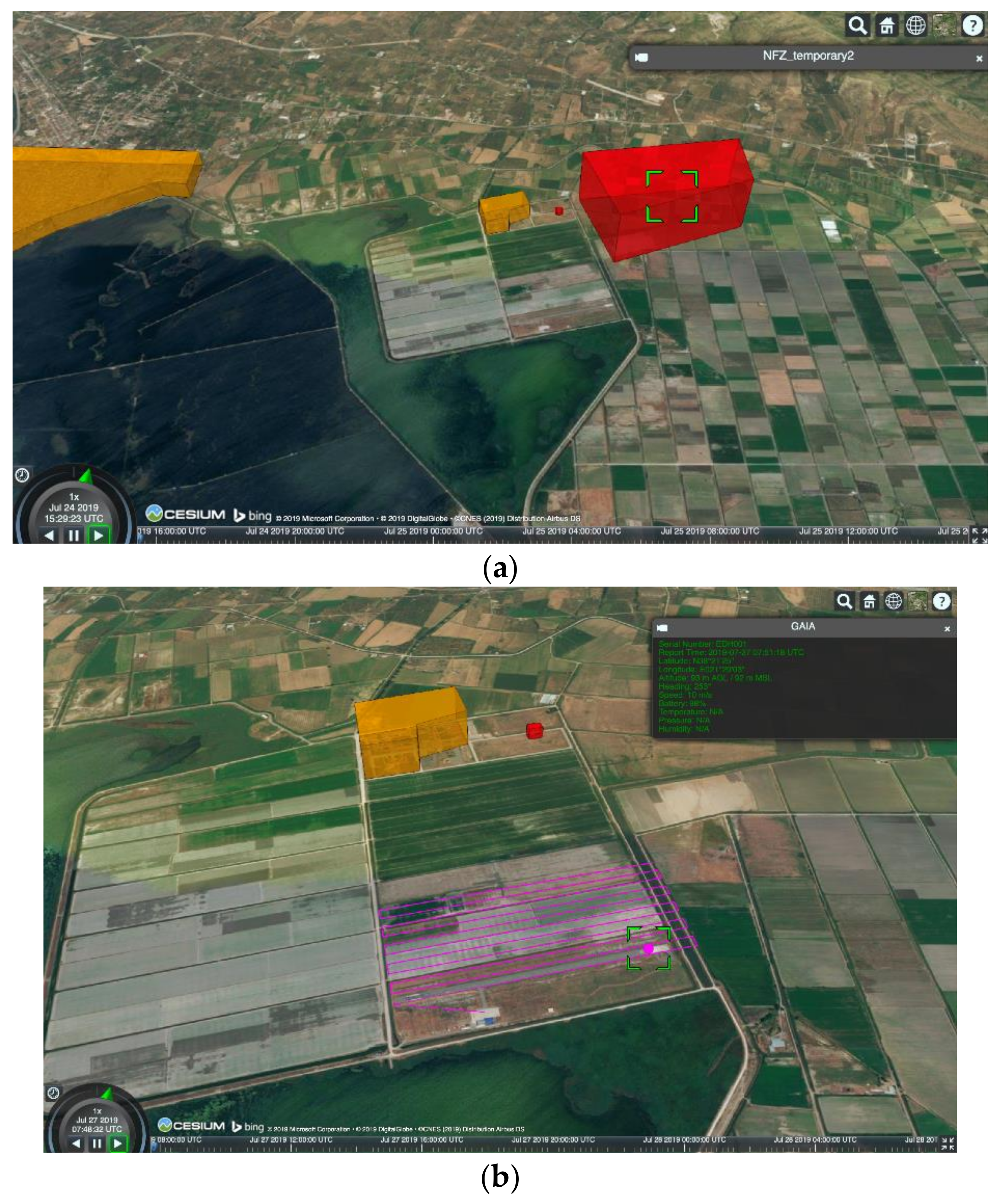
  • Scenario 2: same as Scenario 1, but with the addition of a cooperative General Aviation intruder (or surrogate, e.g., manually operated drone in VLOS with cooperative transmitter as in General Aviation).
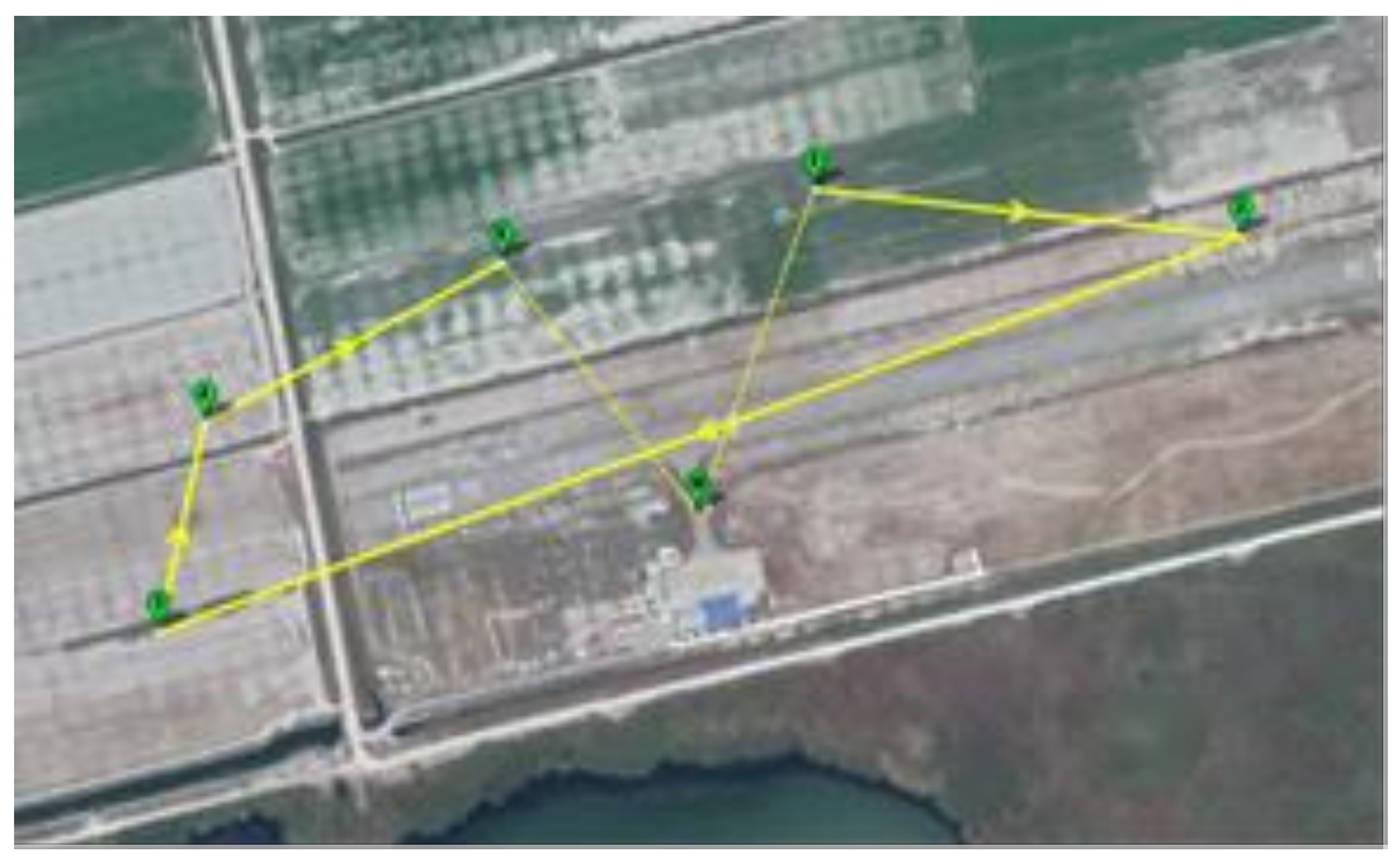
  • Scenario 3: a 5 km-long highly automated BVLOS mission from Messolonghi City (urban area) to Messolonghi Airport, demonstrating a small parcel delivery commercial user case and interaction with an urban environment (Figure 21).
Figure 20 and Figure 21 show the operational scenario implemented in Demonstration No. 2, which was a 10 km-long highly automated BVLOS mission from the ELTA central Post Office in Messolonghi City (urban area) to Messolonghi Airport, demonstrating a small parcel delivery commercial user case and interaction with an urban environment. The demonstration involved the Gaia VTOL UAV in an autonomous take off, e-registration, path planning, sense and performing a fully autonomous avoid/deconfliction procedure followed by BVLOS flight in the 5 to 10 km range. In the demonstration, during which HD video was used to monitor via on-board cameras, the services and capabilities tested included demonstrating small parcel delivery for a commercial user case (Hellenic Post) and interacting with an urban environment, thus emulating a short-range last mile or high-value logistics operations. In the Demo 2 real-world scenarios, the team tried the DronAssistant (Das) with drones equipped with FLARM sensors, arranged tests with the drones to be static on certain positions and distances, and checked the messages provided by FLARM about the distance and the angle difference of the drones. After it was established that the FLARM hardware to the DA was fully working and able to communicate with other devices equipped with FLARM, real-world collision avoidance scenarios were implemented. The full Detect and Avoid System was tested in real-world scenarios, with the drones equipped with the FLARM hardware on the ground for safety reasons and the individual FLARM messages they provide were checked to confirm that the corresponding measurements were correct regarding the distance and angle. To ensure the measurements received were correct and have an estimation about the error, various tests involving movement of drones were implemented. The next step was to modify the simulated scenario to work in real conditions. In this case, one drone was on the ground and the other drone would fly around the area. When the distance between them was under a threshold of 5 m, the Detect and Avoid system was activated and forced the drone to move to a safe area to avoid collision. Various sense-and-avoid tests were implemented with more complex scenarios in order to validate the sense-and-avoid algorithms, hardware and UTM implementation with all tests being successful. Multiple flights (15) for 10 km logistics scenarios were conducted using various rotorcraft drones to simulate UTM traffic (Figure 22).
Figure 21. View during the medium-range BVLOS flight of the Gaia UAV carrying cargo in Demonstration No. 2.
Drones 06 00053 g021
The EuroDRONE test results have shown through Trials #1 and 2 that U-Space technologies level U1 and U2 services can be delivered with existing technologies in a realistic environment, with professional operators performing recurrent business missions. Over 30 test runs were conducted (over 15 in trial 2) using multiple UAV platforms and for different scenarios indicating mission and technology feasibility, flexibility and that built in automation can deliver significant benefits for UTM/U-Space services in U1/2 levels. Table 1, Table 2 and Table 3 show the EuroDRONE achievements and demonstration of U Space U1–U3 services and capabilities attained during the project, pushing the UTM TRL as per Europe’s roadmaps and goals [1,2,3,4,5,6,7,8].
Table 1, Table 2 and Table 3 present the USpace services and capabilities demonstrated by EuroDRONE but also identify areas which still need to be improved and require a TRL push towards a fully operational UTM system. At the project level, it has been demonstrated that for the levels U1/U2, TRL 6–7 maturity potentially can be achieved through further tests and progressive work on software/hardware elements The services and capabilities are at the same level where commercial deployment could be considered, provided, however, that availability and reliability issues (hardware, LTE/4G/3G) could be addressed and further confirmed at the level acceptable for integration into National Airspace. At the moment, not enough data has been compiled to provide a comprehensive report on the reliability of the hardware/software; therefore, for U2 and U3 services, it is recommended that high volume/traffic demonstrations are planned for the near term. At the same time, multiple hardware failure simulations revealed that UAVs pose real risks to human life and property; a potentially dangerous situation can quickly escalate into a hazardous one or even catastrophic, especially near transport and power infrastructure, and without timely intervention of trained personnel it is impossible to guarantee a successful recovery.
The above results also correlate with the findings on the U3/U4 Services and capabilities; while the EuroDRONE tests have shown that, conceptually, it is possible to achieve the levels required, the maturity level is certainly not beyond TRL 4. EuroDRONE has experienced numerous issues with the reliability of commercial off-the-shelf (COTS) hardware, software (both proprietary and supplied by third parties) and for commercial services to take place, further high-volume (10–30 drones) UTM testing using multiple scenarios, in areas and ranges (>10 km) should be implemented by SESAR. Arguably the individual building blocks for U1/U2 services are at a higher TRL (>TRL 6) and should be further developed in practical UTM demonstrations.
While it might be argued that the level of maturity of UTM is adequate for deployment, EuroDRONE’s overall conclusion is that UTM systems remain too complex and fragile to be recommended for immediate (current) commercial deployment as they do not meet the requirements of the safety and reliability levels demonstrated and accepted in manned aviation. Both software and hardware need to be optimised and rigorously tested. The key to the economic viability of commercial UAS applications is in safety, reliability, and standardised, automated, and simplified operations. As the tests demonstrated, the U3 service level clearly remains to be achieved with further specific developments in automation, communication network reliability, use of instrumented air corridors and increased cybersecurity, and should undergo high-volume, extended UTM testing. At the same time, to stimulate R&D, as was the case during EuroDRONE’ s tests, local/regional regulators should be open and flexible towards companies engaged in such transactions, and encourage further tests by gradually lifting restrictions in a controlled environment.
With respect to the missing links for the EuroDRONE project, most issues revolve around the availability and reliability of communications, and do not seem to be concerned about navigation and aviation (aviate, navigate, communicate paradigm). These are thought to be addressed; however, as EuroDRONE’s own tests demonstrated, a number of issues in both departments can and will be compromised when the number of UAVs in the skies goes up. For example, UAV positioning estimates can vary significantly by several meters in some cases, as reported by competing systems (GPS, GLONAS). That potentially limits usability for high-precision applications. The same goes for basic altitude reporting; most systems today use GNSS-derived data, which is not accepted in manned aviation (which relies on barometric sensors) and can lead to potential conflicts. EuroDRONE also experienced some hardware abnormalities, which led to the tests of emergency procedures—although these had been planned in advance, the hardware failures (sensors, UAV hardware) did not occur where they were anticipated, limiting the ability of the operator to respond.

4.4. Demonstration Recommendations

EuroDRONE demonstrated key U1/U2 services and technologies and some U3 capabilities, and has proposed the following activities/areas which require further development:
  • Availability of robust mobile network (LTE4G/3G) coverage, in particular in UAV and UTM flight corridors (>98% coverage)
  • Requirement of detailed maps of the geographical areas of operation (1:50,000 or 1:100,000)
  • Robustness of critical hardware such as sense-and-avoid sensors, which are at a low TRL (e.g., FLARM sensors required extensive calibration and had many software challenges), drones (platform reliability, ground station RF links)
  • Requirements of RADAR sensors for drone tracking, in particular for UAV flight corridors
  • Increased autonomous UTM-ATC links and operations

5. Conclusions

EuroDRONE was able to validate multiple complex UTM technologies and services through two practical demonstrations which took place in July and October 2019 at the Airport of Messolonghi in Greece, with the following objectives met: (i) innovative vehicle-to-infrastructure link (V2I), integrated with a self-learning UTM platform, with the capability to share flight information in real time. (ii) Demonstration of end-to-end UTM applications focusing on VLOS/BVLOS logistics and blue light services. (iii) Advanced autonomy and logistics applications. Using novel UTM technologies, an automated cloud-based UTM system connected to a miniature, intelligent transponder/processing board on drones with the full authority for flight mission planning was used and tested in multiple, realistic practical UTM trials which demonstrated key U1/U2 services and technologies and some U3 capabilities; the following activities/areas are proposed to require further development: (i) availability of robust mobile network (LTE4G/3G) coverage, in particular in UAV and UTM flight corridors (>98% coverage); (ii) requirement of detailed maps of the geographical areas of operation (1:50,000 or 1:100,000); (iii) robustness of critical hardware such as sense-and-avoid sensors, which are at a low TRL (e.g., FLARM sensors required extensive calibration and had many software challenges) and drones (platform reliability, ground station RF links); (iv) requirements of RADAR sensors for drone tracking, in particular for UAV flight corridors; (v) increased autonomous UTM-ATC links and operations. There is a clear need for UTM/U-Space standards (sense and avoid, confirmation of right-of-way separation distances, deconfliction rules) and specific standards for hardware critical to UTM (sense-and-avoid sensors, UAV tracking, e-registration) which need to be applied in a common and streamlined manner in Europe for commercial UTM uptake. Regulation with respect to U-Space operations (ground rules, separation, ATC links and responsibilities, e-registration) requires large-scale U-Space demonstrations (use of 20–30 drones in urban areas with multiple providers, services, and long-duration testing scenarios) for validation in urban and semi-urban areas. EuroDRONE demonstrated a very high level of automation, and it is clear that an increased level of autonomy for UTM and its link to cybersecurity need to be addressed and improved. EuroDRONE has proven the feasibility of automated UTM for small numbers of drones and for most level 1 and 2 U-Space services. Maturity for these services is at a TRL of 7, with automation being at a TRL of 5.

Author Contributions

Conceptualization, V.L., M.T. and D.S.; methodology, H.-S.S. and J.M.; software, H.I.L.; validation, G.Z., E.A., A.M., T.M., A.T. (Antonios Tsourdos) and A.T. (Andra Trifas) investigation; writing—V.L., original draft preparation, writing—review and editing; project administration, V.K. All authors have read and agreed to the published version of the manuscript.

Funding

The EuroDRONE U-Space project has received funding from the SESAR Joint Undertaking under the European Union’s Connection Europe Facility (CEF) program under grant agreement SJU/LC/342-CTR. Project website: http://www.aml.eurodrone.upatras.gr/, accessed on 1 February 2022.

Institutional Review Board Statement

Not applicable.

Informed Consent Statement

Not applicable.

Data Availability Statement

Not applicable.

Acknowledgments

The EuroDRONE team would like to thank the technical officer Ludovic Legros of SESAR for his useful advice and technical monitoring of the project.

Conflicts of Interest

The authors declare no conflict of interest.

Abbreviations

ATMAir Traffic Management
ATCAir Traffic Control
BVLOSBeyond Visual Line of Sight
CACollision Avoidance
CAACivil Aviation Authority
APFArtificial Potential Field
DAADetect & Avoid
DGCDifferential Geometry Concept
EASAEuropean Aviation Safety Agency
GAGeneral Aviation
GNSSGlobal Navigation Satellite System
HCAAHellenic Civil Aviation Authority
ICAOInternational Civil Aviation Organization
NASANational Aeronautics and Space Administration
NFZNo Fly Zone
PSOParticle Swarm Optimisation
QoSQuality of Service
ROSRobot Operating System
SARSearch and Rescue
SESARSingle European Sky ATM Research
TDTactical Deconfliction
UASUnmanned Aircraft System
USMU-space Service Manager
UTMUnmanned aerial system Traffic Management
V2VVehicle to Vehicle
V2IVehicle to Infrastructure
VLLVery Low Level
VLOSVisual Line of Sight

References

  1. SJU. European Drones Outlook Study, Unlocking the Value for Europe (November 2016); SESAR Joint Undertaking: Brussels, Belgium, 2016. [Google Scholar]
  2. SJU. Blueprint on U-Space; SESAR Joint Undertaking: Brussels, Belgium, 2018. [Google Scholar]
  3. EUROCONTROL. UAS ATM Integration Operational Concept; EUROCONTROL: Brussels, Belgium, 2018. [Google Scholar]
  4. SJU. European ATM Master Plan; SESAR Joint Undertaking: Brussels, Belgium, 2015. [Google Scholar]
  5. Barrado, C.; Boyero, M.; Brucculeri, L.; Ferrara, G.; Hately, A.; Hullah, P.; Martin-Marrero, D.; Pastor, E.; Rushton, A.P.; Volkert, A. U-Space Concept of Operations: A Key Enabler for Opening Airspace to Emerging Low-Altitude Operations. Aerospace 2020, 7, 24. [Google Scholar] [CrossRef] [Green Version]
  6. SESAR U-Space Projects. Available online: https://www.sesarju.eu/node/3202 (accessed on 1 December 2021).
  7. SESAR Drone Outlook Study. 2016. Available online: https://www.sesarju.eu/sites/default/files/documents/reports/European_Drones_Outlook_Study_2016.pdf (accessed on 14 May 2021).
  8. EU Aviation Strategy. Available online: https://ec.europa.eu/transport/modes/air/aviation-strategy/innovation (accessed on 14 May 2021).
  9. Declaration, W. Drones as a leverage for jobs and new business opportunities. In Proceedings of the Conference on Drones as A Leverage for Jobs and New Business Opportunities, Warsaw, Poland, 23–24 November 2016. [Google Scholar]
  10. Federal Aviation Administration. Unmanned Aircraft Systems (UAS) Traffic Management (UTM) Concept of Operations (v2.0). 2020. Available online: https://www.nasa.gov/sites/default/files/atoms/files/2020-03-faa-nextgen-utm_conops_v2-508_1.pdf (accessed on 1 February 2022).
  11. National Aeronautics and Space Administration (2018) UTM UAS Service Supplier Development—Sprint 2 Toward Technical Capability Level 4 (NASA/TM-2018-220050). NASA Ames Research Center. Available online: https://utm.arc.nasa.gov/docs/2018-UTM_UAS_TCL4_Sprint2_Report_v2.pdf (accessed on 1 February 2022).
  12. Oosedo, A.; Hattori, H.; Yasui, I.; Harada, K. Unmanned Aircraft System Traffic Management (UTM) Simulation of Drone Delivery Models in 2030 Japan. J. Robot. Mechatron. 2021, 33, 348–362. [Google Scholar] [CrossRef]
  13. Global UTM Association. Designing UTM for Global Success; Technical Report; Global UTM Association: Lausanne, Switzerland, 2020. [Google Scholar]
  14. Lappas, V.; Zoumponos, G.; Kostopoulos, V.; Shin, H.Y.; Tsourdos, A.; Tantarini, M.; Shmoko, D.; Munoz, J.; Amoratis, N.; Maragkakis, A.; et al. EuroDRONE, A European UTM Testbed for U-Space. In Proceedings of the 2020 International Conference on Unmanned Aircraft Systems (ICUAS), Athens, Greece, 1–4 September 2020; pp. 1766–1774. [Google Scholar] [CrossRef]
  15. Dronsystems Company Website. Available online: https://www.dronsystems.com (accessed on 1 February 2022).
  16. Cooperative Departures for a Competitive ATM Network Service—PARTAKE, SJU SESAR Grant Agreement ID: 699307. Available online: https://www.sesarju.eu/node/3182 (accessed on 1 February 2022).
  17. Ramos, J.J.; Schefers, N.; Radanovic, M.; Piera, M.A.; Folch, P. A Constraint Programming Model with Time Uncertainty for Cooperative Flight Departures. Available online: https://pdfs.semanticscholar.org/be0f/1b0880b6eb560aefd716698ceaaaa756d539.pdf (accessed on 9 February 2022).
  18. Lee, H.I.; Shin, H.S.; Tsourdos, A. UAV Collision Avoidance Considering No-Fly-Zones. IFAC-Pap. Line 2020, 53, 14748–14753. [Google Scholar] [CrossRef]
Figure 1. U-space Levels of Service [1,2,3,4,5].
Drones 06 00053 g001
Figure 2. EuroDRONE Architecture and Functionalities (Level or U1-3).
Drones 06 00053 g002
Figure 3. EuroDRONE Deployment.
Drones 06 00053 g003
Figure 4. EuroDRONE Deployment Processes.
Drones 06 00053 g004
Figure 5. DronAssistant prototype for U3 (with DAA, V2I, V2V).
Drones 06 00053 g005
Figure 6. DroNav submitted missions list and status.
Drones 06 00053 g006
Figure 7. DroNav submitted missions list and status—example of explanation of mission not approved.
Drones 06 00053 g007
Figure 8. DroNav example of mission not approved displayed on map (at Messolonghi airport in Greece).
Drones 06 00053 g008
Figure 9. Mission planner–PARTAKE timeline interactions for (A) denial (B) take off.
Drones 06 00053 g009
Figure 10. DAA Simulation Results. (a) CA trajectory (1 scenario). (b) Intruder trajectory (100 scenarios). (c) Minimum distance to intruder/obstacle (100 scenarios). (d) Total flight time to reach the waypoint (100 scenarios).
Drones 06 00053 g010
Figure 11. Three drones in VLOS operations and two drones in fully automated BVLOS operations utilizing the DronAssistant.
Drones 06 00053 g011
Figure 12. EuroDRONE fixed-wing VTOL ‘BabyShark’ (left) and hexacopter ‘GAIA’ (right).
Drones 06 00053 g012
Figure 13. Dronav mission planner overview interface with an approved mission for Demo 1.
Drones 06 00053 g013
Figure 14. VLOS Flight at Messolonghi Airport.
Drones 06 00053 g014
Figure 15. Demo 1 mission that the UAV had to execute.
Drones 06 00053 g015
Figure 16. UAV stopped its mission and moved to a safe area in order to avoid the fixed obstacle.
Drones 06 00053 g016
Figure 17. The mission that was executed by the UAV.
Drones 06 00053 g017
Figure 18. EuroDRONE Scenario 1 Testing for multiple mission scenarios: (a) Dynamically Geofenced UTM Testing Area with GAIA UAV starting point—geofenced, (b) Scenario 1 Test with Geofenced Area and for a SAR/Precision Agriculture UAV Scenario—precision agriculture, and (c) Scenario 1 Testing with Logistics (VLOS) Scenario over Messolonghi Airport—logistics with on-going aviation traffic near the airport.
Drones 06 00053 g018aDrones 06 00053 g018b
Figure 19. Trial 1 Testing Scenario Summary with Multiple UAVs.
Drones 06 00053 g019
Figure 22. EuroDRONE Team after Demo 2 Flight Testing.
Drones 06 00053 g022
Table 1. U1 Services and Capabilities Demonstrated in EuroDRONE.
U1 ServicesMain Expected Benefits/Usefulness (e.g., Gain Time, Improve Efficiency, Avoid IntrusionMain Potential Issues (e.g., Interoperability, Accuracy, Time Criticality, Readability)
U1 servicesE-registrationFull e-registration of vehicles both on online database and on drone, with RF beacon (for recreational users and commercial users operating in VLOS) or DronAssistant (for commercial BVLOS).Recreational users will remain complacent and will not register their assets without adequate enforcement
E-identificationRF beacon, 2.4 GHz, encryptedCompatibility of versions from different vendors. Relatively short range
Pre-tactical geofencingAutomated/in combination with ATC. Implemented also via simulation, which cancels each mission that occupies a non-flying volume or NOTAMNeed to assess automation for large number of drones/services
U1 capabilitiesE-identificationVia RF beacon, 2.4 GHz, encrypted.Interoperability; congested frequency; low range
On-drone geofencingAlert to operator for the case of recreational drone with RF Beacon.GNSS accuracy and availability
SecurityData encrypted in motion.Bandwidth imposes restrictions on the technology used
TelemetryTransferred both by RF Beacon and DronAssistant Flight Director.Connection availability and stability
Command & controlRedundant: it makes use of cellular network but ultimately relies on onboard decision making via mission flight director.Not identified at the moment
Communication, navigation and surveillanceProvided by DronAssistant, in conjunction with DroNav. Only a limited number of assets have been tested; scalability may present additional requirements
Operations managementManaged by DroNav.Extended operations may present additional challenges
Table 2. U2 Services and Capabilities Demonstrated in EuroDRONE.
U2 ServicesMain Expected Benefits/Usefulness (e.g., Gain Time, Improve Efficiency, Avoid IntrusionMain Potential Issues (e.g., Interoperability, Accuracy, Time Criticality, Readability)
U2 servicesTactical geofencingAutomated on DroNav-DronAssistant and in combination with ATC/Hellenic Civil Aviation Authority. GNSS Availability and reliability. Timely Database updates
Emergency ManagementPossibility to give emergency landing command via cellular network and other options open to implementation under civil aviation authority request, including automated commands that can be given by the DronAssistant with no need for a communication link with the ground.Multiple hardware failures may prevent operators from addressing potential issues
Strategic de-conflictionIn-house tools will be used as a webservice for drone operators detecting potential conflict with other missions operating in the same airspace and mitigating them, applying a time departure shift inside the launch window interval assigned by the ecosystem manager. Additionally, synthetic traffic will be injected in this service in order to simulate several operators acting in the same airspaceStrategic deconflicting service is based on an API webservice ready to be integrated in any mission planner, ensuring interoperability. The ID of the missions under conflict is kept transparent to operators ensuring confidentiality. The strategic deconflicting service allows the airspace manager to filter just the missions operating in a given airspace block, allowing a distributed deployment of the deconflicting tool (those missions operating in several airspace blocks are recorded in the different databases associated to each block).
Weather informationIntegrated into DroNav and automatically checked for the specific drone model used.Accurate information available only at either the ground level or higher levels.
TrackingVia DronAssistant, via cellular network. A future option includes satellite comms when cellular signal is too weak or non-existent.Availability, bandwidth and reliability of the network; hardware failure; satcom remains expensive
Flight planning managementOn DroNav cloud.Not identified at the moment
MonitoringDroNav monitors what reported by DronAssistant.Not identified at the moment
Traffic informationCooperative General Aviation (GA) detected by DronAssistant. Non-cooperative GA submits a temporary NFZ via user friendly DroNav interface. Data detected by ground radar might be fused into DroNav database. ATC has full situation awareness, and it can both give instructions to drone operators and eventually (if wanted) commands to drones (via DronAssistant). PARTAKE tool will strategically mitigate/reject all missions in conflict with GA.Not all GA assets activate Mode S on which DronAssistant relies. Low-level radar coverage from outside ATZs is limited. ATC with remote ATZ responsibility at the moment are addressed on a case-by-case basis
Drone AIMCAA will provide NOTAMS and no-fly zone description, while DronNAV will incorporate information about fixed obstacles. Databases provide integrated fixed obstacles location, mitigating missions in conflict.On-board processing power limitations and channel bandwidth force a choice between accuracy and the size of the area of operations
Procedural interfaces ATCATC has access to DroNav systems, both in terms of flights schedule and status. Learning curve for ATCOs and standardisation of messages, phraseology, qualifications
Legal recordingData reported by DronAssistant is storedNot identified
Accident and incident reportingSections on DroNav portal.Not identified
Digital LogbookStored on DroNav backend cloud.Not identified
Geographic informationDigital elevation model included in DroNav, altitude of the drone (via DronAssistant) both in AGL and MSL. Any further information of any shape can be added, submitting it to DroNav and with the data also stored on DronAssistant. At the moment, DA relies on GNSS altitude.
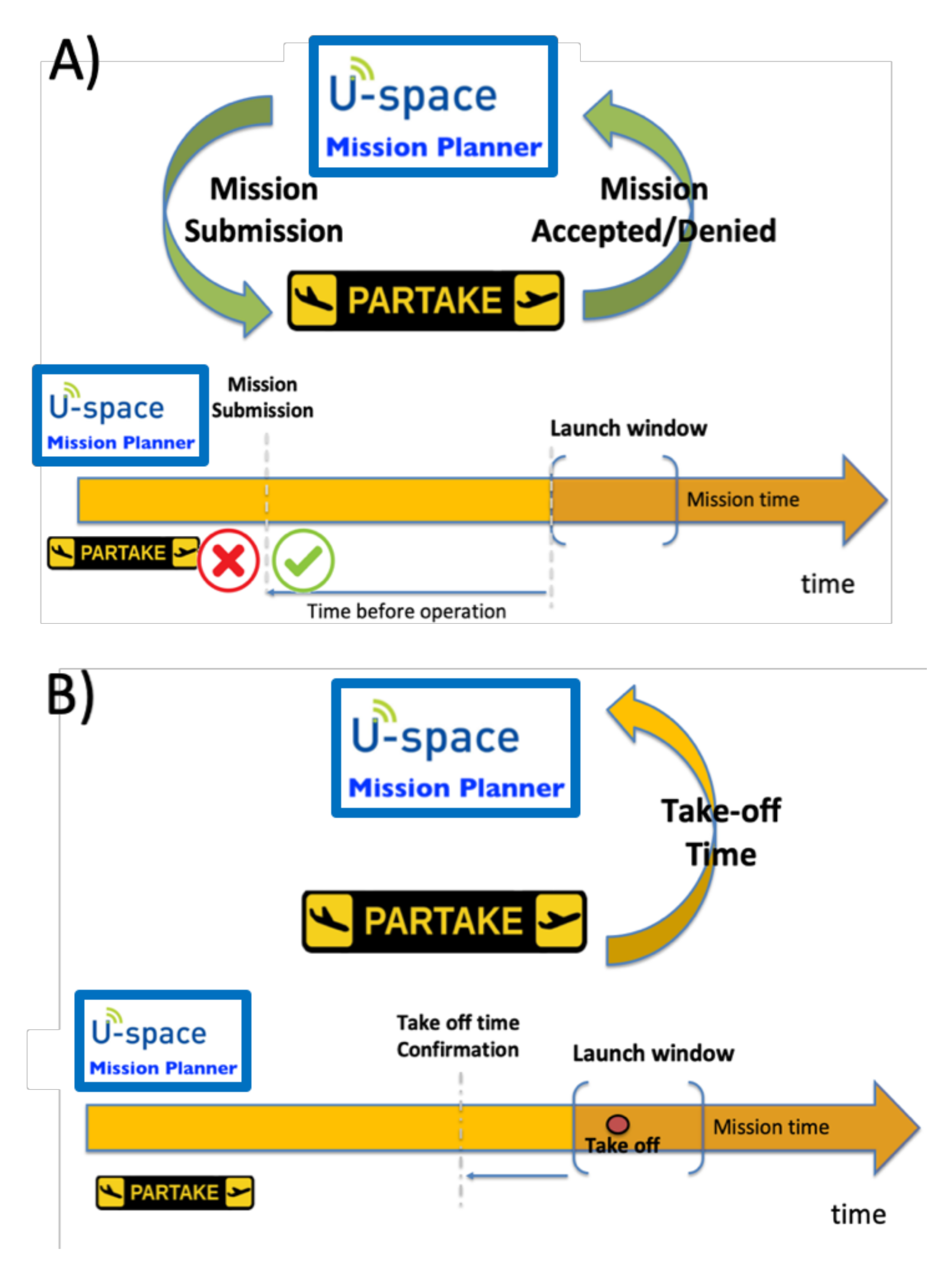
Flight plan preparation/optimization assistanceIn the current version of EuroDRONE system, waypoints are not modified when a flight plan is submitted, but DroNav, interacting with in house UTM tools, can anticipate or postpone the take-off time respect to the one submitted by the operator in order to approve a flight plan that is otherwise rejected due to conflicts with other flights.Current models provide a conflict free take-off time 5 s after the submission of the mission, ensuring an acceptable response time.<break/><break/>Beyond those that are being addressed, not identified at the moment
U2 capabilitiesTrackingVia DronAssistant, via cellular network. A future option includes satellite comms when cellular signal is too weak or non-existent.Beyond those that are being addressed, not identified at the moment
Emergency recoveryPossibility to give emergency landing command via cellular network and other options open to implementation under civil aviation authority request, including automated commands that can be given by the DronAssistant with no need for a communication link with the ground.Beyond those that are being addressed, not identified at the moment
Table 3. U3 Services and Capabilities Demonstrated in EuroDRONE.
U3 ServicesMain Expected Benefits/Usefulness (e.g., Gain Time, Improve Efficiency, Avoid IntrusionMain Potential Issues (e.g., Interoperability, Accuracy, Time Criticality, Readability)
U3 servicesEmergency ManagementAs in U2Beyond those that are being addressed, not identified at the moment
Dynamic geofencingIf a new NFZ is added while drone is already airborne, it is pushed up to DronAssistant and automated path modification can be implemented.Reliability and availability of GNSS signal; no guarantee that all assets will have the latest update or be compatible
Tactical de-conflictionIf a new NFZ (associated with a non-cooperative GA) is added while drone already airborne, it is pushed up to DronAssistant and automated path modification can be implemented.A range of issues, mostly stemming from interoperability, compatibility and hardware/software reliability
TrackingAs in U2As in U2
MonitoringAs in U2As in U2
Traffic informationAs in U2Non-cooperative traffic can only be addressed through technology which is not yet mature enough to be recommended
Drone AIMHCAA will provide NOTAMS and no-fly zone description, while DronNAV will incorporate information about fixed obstacles and PARTAKE will take into account while cancelling missions that interact with them.
Collaborative interfaces ATCAs in U2Learning curve for ATCOs and standardisation of messages, phraseology, qualifications
Dynamic capacity managementFirst implementation involves use of in-house UTM tools (UTM) to modify take off-times so that mission plans that have been rejected due to interference with other paths are approved.PARTAKE service is able to map and classify<break/>the missions submitted according to the section of the airspace where they will be executed, knowing the capacity of each airblock.
U3 capabilitiesV2VDronAssistant to DronAssistant.Technology only works with compatible assets, despite most manufacturers including the relevant comm channels (such as 2.4/5GHz), no single standard on utilisation. Low range and high speed will limit Total Reaction Time to unacceptable levels
Detect & avoidImplemented on DronAssistant, detecting cooperative intruders (GA) and executing onboard collision resolution algorithms, then pushed and executed by the drone autopilot. Radar to detect fixed or slowly moving non-cooperative obstacles not in database might be added at the end of the EuroDRONE activity.Low-level radar coverage: limited on-board processing power is likely to restrict the number of assets which could be safely managed without standardised protocols
V2IDroNav-DronAssistant-DroNav.Availability and reliability of the network; weather and landscape affect long- and medium-range comms; interference on busy frequencies in congested areas
Publisher’s Note: MDPI stays neutral with regard to jurisdictional claims in published maps and institutional affiliations.

