Abstract
Human risk has further increased within the global maritime industry because of the coronavirus disease (COVID-19) pandemic. It also impacted the economic activity within the Caribbean islands, including its ship–shore delivery sector. Traditionally, this service includes human interface presenting safety and health hazards, and vessels employed operate on fossil fuels, releasing emissions that contribute to harmful GHG and air pollution. Opportunities have arisen for local maritime companies to introduce innovative strategies within the industry to rectify these challenges. Implementing unmanned aerial system (UAS) technology can reduce operational costs, human risk, environmental impact, and delivery time. This study assessed the feasibility of a UAS ship–shore delivery service to optimize near-harbor deliveries within six major ports of Trinidad. Data was gathered through field observations, a literature survey, questionnaires, and interviews with relevant stakeholders. Based on the above approach, the needs of the local ship–shore delivery sector were identified and categorized. An appropriate UAS which addressed these needs while maintaining the economic, environmental, and human safety requirements was then identified. Recommendations for overcoming the local implementation and operational challenges that were encountered are presented. This study may serve as a reference for conceptualizing a UAS ship–shore delivery service and offers resolutions for similar implementation challenges.
1. Introduction
An unmanned aerial system (UAS) refers to an unmanned aircraft vehicle (UAV), a control station, and a data link [1]. UAS platforms typically fall into one of the following categories: fixed-wing, multirotor, fixed-wing hybrid, blimps, or flapping-wing UAVs. This report refers to a UAS as a system that incorporates a multi-rotor drone. Technological advancements have increased the capabilities of these systems, creating the potential for the extensive use of UASs in everyday endeavors.
One of the many critical supply chains of the global maritime industry is the ship–shore delivery sector. This sector facilitates seagoing vessels at anchorage, providing vital supplies such as spares, stores, samples, documents, medical and emergency supplies [2]. Ship–shore delivery providers, have utilized traditional delivery methods for several years, primarily involving transportation by small high-speed boats. The pandemic has exposed many vulnerabilities within the ship–shore delivery sector, increasing safety and health risks.
A drastic reduction occurred in maritime business activities globally due to precautionary measures to prevent the proliferation of the pandemic [3]. Although the Caribbean region escaped the high mortality rates seen in many other areas around the globe, it is undergoing the adverse effects of the global economic fallout [4]. Like many other Caribbean islands, Trinidad (the larger island of Trinidad and Tobago) has experienced significant economic decline, which led to the downsizing of maritime labor forces.
Traditionally launch boats require a minimum crew of three certified persons. The unpredictable nature of the marine environment, coupled with the human error involved in the maintenance and repair of the various systems onboard these local launch boats, have presented high risks to the safety of seafarers [5,6]. The compact size of these vessels further increases operational risks due to COVID-19 spread through human interaction [7].
The goal of reducing greenhouse gas (GHG) emissions by at least 50% before 2050 when compared to 2008 levels established by the International Maritime Organization (IMO) has set the pathway for a paradigm shift within the shipping industry towards low carbon choices for ships, ports, and maritime supporting services [8]. Boats traditionally used for near harbor ship–shore deliveries remain heavily reliant on fossil fuels to operate, contributing to GHG emissions and air pollution. Therefore, an opportunity has arisen within local ship–shore delivery operations to introduce innovative strategies and technologies, such as UASs, to secure a sustainable future within this sector.
Theoretically, UASs have proven beneficial from an economic perspective and can decrease the traditional levels of human risk while reducing carbon footprint and air pollution [9,10,11]. Maritime drone deliveries are currently being utilized within the ports at Rotterdam and Singapore with great success [2]. However, it is essential to note that operational dynamics and each country’s unique legislative and governance structures are integral when implementing any new approach. This study assesses the potential use of a UAS ship–shore delivery service to optimize near harbor delivery operations within the crucial ports of Trinidad. The feasibility was determined by comparing the economic benefits, human risk factors, and environmental impact between the locally utilized launch boats and a proposed UAS. The local implementation and operational challenges were identified and analyzed. Additionally, remedial suggestions for these challenges are presented.
This paper initially provides a brief description of the study area, explains the adopted research method, and then outlines the findings. The results are then discussed and analyzed and a summary of outcomes, recommendations, and future developments are provided.
2. Description of the Study Area
As seen in Figure 1, Trinidad is the southernmost Caribbean Island forming part of the Republic of Trinidad and Tobago. The twin-island nation is a middle-income country with relatively strong institutions, political stability, and a mature energy market, contributing significantly to economic development [12]. The western body of water bordering the island, known as the Gulf of Paria, provides a relatively sheltered and calm natural harbor situated beyond the Caribbean’s hurricane belt [13]. These factors attract a variety of maritime operations, including loading/offloading, bunkering, transshipment, and dry-docking operations to this location.
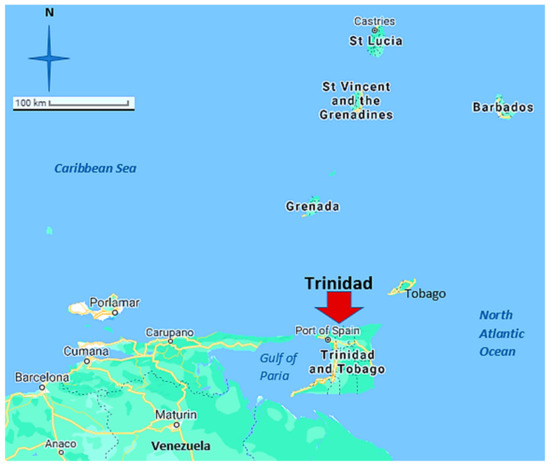
Figure 1.
Trinidad’s location. Adapted from [14].
The profile of maritime traffic within Trinidad and Tobago for the year 2019 is presented below in Table 1.

Table 1.
Port calls, time spent in ports, vessel age, and size in 2019 [15].
Trinidad has two major cargo ports; Port of Point Lisas and Port of Port of Spain, which are among the most highly developed and recognized in the Caribbean [16]. Additionally, the country has liquid and dry bulk handling facilities and liquefied natural gas (LNG) handling facilities. The Port of Port of Spain, located on the seafront of Trinidad’s capital city, is the biggest in the state and has been identified as a central transshipment point within the Caribbean region [16]. Trinidad’s natural harbor operations require significant support services to obtain integral stores, spares, samples, and other necessities. Ship–shore delivery companies provide an essential and lucrative service in the everyday functions of the various maritime operations within the Gulf of Paria.
UAS use in other sectors can help bridge the gap in maritime-specific implementations, as similarities benefit all users [9]. However, additional research and observations in the local maritime industry are essential to accurately assess the practicability of a UAS ship–shore delivery service within Trinidad’s leading ports. The main ports described in this report are located on the island’s west coast, bordered by the Gulf of Paria, and refer specifically to the ports located in Chaguaramas, Port-of-Spain, Point Lisas Pointe-a-Pierre, La Brea, and Point Fortin. Figure 2 displays the geographical location of these main ports.
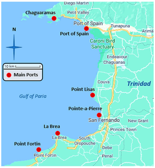
Figure 2.
Main Ports in the Gulf of Paria, Trinidad. Adapted from [17].
3. Methods
The following section explains the adopted research method to determine the feasibility of a UAS ship–shore delivery service within the main ports on the west coast of Trinidad.
3.1. Objectives
The main objectives were as follows:
- To quantify and categorize the needs for ship–shore delivery within the local maritime industry.
- To determine an appropriate UAS for the local maritime industry.
- To establish the economic, environmental, and human safety advantages of the proposed UAS ship–shore delivery service.
- To identify the requirements and resolutions for challenges regarding the local implementation and operation of the proposed system.
3.2. Field Data Collection
The needs of the ship–shore delivery sector were first identified to develop a clear understanding of ship–shore delivery within the local maritime industry regarding the frequency, range, and characteristics over three years [9]. This information was supplemented with data collected using a questionnaire. The questionnaire was specifically designed to gather the demand and operational details of the sector.
Questionnaires were distributed to the significant ship–shore delivery providers operating within Chaguaramas, Port-of-Spain, Point Lisas/Yara, Pointe-a-Pierre, La Brea, and Point Fortin. Some of the questions included were explicitly designed to establish the local payload requirements and frequency of deliveries within the industry [2,9,18]. The questions were aimed at capturing information for three years; 2018, 2019, and 2020. This period was chosen to capture both pre-pandemic and post-pandemic data. Monthly average delivery demand data acquired was categorized by weight. The information collated helped to determine the suitability of a UAS to service the sector. In addition, an initial analysis of the implementation cost of various UASs was used to determine the most cost-effective resolution considering payload limitations.
3.3. UAS Selection
An appropriate UAS for the local maritime industry was identified by establishing the local requirements regarding the payload capabilities, delivery range, and average weather conditions [1,9,19]. The flight range requirement of service was determined by reviewing nautical charts. This review considered areas of densely anchored vessels at the various anchorages of the stated ports. Furthermore, the applicable ‘No Fly Zones’ enforced around these areas were considered, and several appropriate UAS launching locations were identified onshore. The flight range in this study refers to the distance between the UAS launching points and the respective anchorages. Flight paths were determined for each of the specified ports. The launching points were decided based on ease of accessibility and avoidance of hinterland traffic. The round-trip distances of these paths were considered when determining the required UAS range.
Average annual weather conditions were gathered from the local meteorological service. Weather conditions referred to the temperature, wind speeds, humidity, and visibility in which the UAS operates [9]. Information on UASs that can safely operate within specific ranges of the factors mentioned above was requested from several UAS providers. A few providers were reluctant to share information regarding operating and lifecycle costs. Several UAS specifications were reviewed, and an applicable system was chosen based on cost efficiencies, ease of accessibility, and competencies.
3.4. Economic, Environmental, and Human Safety Considerations
Information on the chosen UAS regarding capital expenditure, manning requirements, utilities, limitations, and carbon dioxide (CO2) emissions were obtained from the manufacturer’s specification sheets and field research [2,10,20]. A literature review and extensive field observations supported by several questions included in the questionnaire were employed to gather data on the local delivery vessels currently used. Information on capital expenditure, manning requirements, and fuel consumption for the local vessels were captured via the questionnaire. Additional data was gathered by reviewing the specification sheet for one of the most common brands of engines utilized by local ship–shore delivery companies.
The results of the UAS and launch vessel investigations were then tabulated for ease of comparison to understand the advantages and disadvantages of employing each method. This comparison assisted in identifying the implementation challenges and practical solutions [2]. The unavailability of operational maintenance costs for both approaches led to a limitation in the comparison. As a result, these costs were not considered in this study.
3.5. Local Implementation and Operational Requirements
The identification of the local authorities with the statutory responsibility for management and regulation of UAS operations within Trinidad and Tobago was a fundamental step towards implementation [9,19,20]. These authorities were identified through field research and networking. Information request letters were forwarded to these entities, and online interviews were conducted with the appropriate representatives. The discussions resulted in a compilation of applicable local legal frameworks regarding implementing and operating the proposed UAS ship–shore delivery service.
The applicable implementation and operational challenges were identified by examining UAS applications in other states and evaluating the local operating dynamics, legal framework, and governance structure [1,19]. Resolutions for the identified challenges were determined by reviewing UAS frameworks seen in other jurisdictions such as the United States of America and several countries within the European Union. In addition, one of the qualitative questions included in the questionnaire aimed to gather the local human acceptance of UAS implementation [2].
4. Results
This section outlines the findings of the methods employed as described in the previous section. These findings were grouped in four sub-sections corresponding to the objectives of the study.
4.1. Demand for Ship–Shore Delivery
The information collated and displayed in this section indicated the local demand for ship–shore delivery and helped determine the suitability of a UAS to service the local sector.
4.1.1. Major Stakeholders
The four significant stakeholders currently providing ship–shore delivery within the main ports identified are:
- Paria Fuel Trading Company Limited
- Oldendorff Carriers Trinidad and Tobago Limited
- National Energy Corporation
- Bridge Control Services Limited
Two providers took a protectionist approach as they were reluctant to divulge any data regarding the details of their operations.
4.1.2. Demand Data
The compiled average data of the ship–shore package deliveries in Trinidad’s major ports are displayed below in Table 2.
Table 2.
Total annual ship–shore deliveries.
According to the available data collected, the average monthly ship–shore deliveries comprised 32% Droghers (explained in Section 5) related deliveries 3 kg and under, 25% involved packages above 3 kilograms (kg) up to 30 kg, and 43% involved packages over 30 kg. Crew change operations were not taken into consideration within these figures. This information is represented in Figure 3.
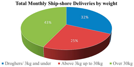
Figure 3.
Total monthly ship–shore deliveries.
4.2. Suitable UAS for Local Ship–Shore Delivery Service
The pre-survey revealed that the most cost-effective resolution regarding payload weight capacity of UASs ranged between 5 and 30 kg. The data collected and displayed in Figure 3 indicated that a 30 kg payload capacity would be adequate to facilitate 57% of the local deliveries.
4.2.1. Required Characteristics
As seen in Table 1, oil and gas tankers represent over 10% of total vessels operating within Trinidadian waters. To continue facilitating deliveries to these tankers, the UAS should have intrinsically safe operating capabilities. The Trinidad and Tobago Meteorological Service [21] provided average local weather conditions: temperature from 31.3 to 22.7 degrees Celsius, humidity 100%, and wind speed from 32 to 12 kilometers (km) per hour. Any selected UAS, therefore, must be able to operate within these parameters. Trinidad also periodically experiences clouds of Saharan dust, which leads to poor visibility; thus, the proposed UAS should be capable of operating Beyond Visual Line of Sight (BVLOS).
Figure 4 illustrates the approximate UAS flight paths, which established the required flight ranges: Chaguaramas—8 km; Port-of-Spain—9 km; Point Lisas—9 km; Pointe-a-Pierre—5 km; La Brea—1 km; and Point Fortin—9 km. An appropriate operating data link range should be further than the longest flight range of 9 km. Therefore, UAS with a 10 km flight range and a 20 km round-trip capability would satisfy the needs of the identified ports.
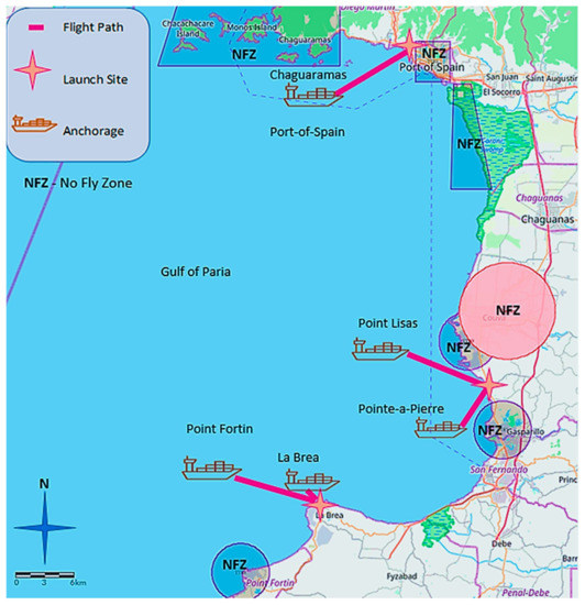
Figure 4.
UAS proposed flight path in the Gulf of Paria, Trinidad. Adapted from [22].
4.2.2. Available Providers and Options
The available UAS manufacturers and their options were identified, and specification sheets of these options were compared to the above-mentioned local requirements. Table 3 shows the UAS options that were considered suitable for the proposed delivery service.
Table 3.
Comparison of suitable UAS options [23,24,25,26,27].
4.2.3. Recommended UAS
Griff Aviation’s Griff 135 was identified as a suitable system, as it was readily available and best suited for the local requirements with intrinsically safe and marine operational capabilities.
4.3. Comparison of a Proposed UAS and Local Launch Boats
Table 4 compares the operational and technical characteristics of the Griff 135 and the launch boats traditionally used in the local sector.
Table 4.
Comparison of a proposed UAS and local launch boats.
4.4. Applicable Requirements/Implementation and Operational Challenges
This sub-section identifies the requirements regarding the implementation and operation of the proposed system for Trinidad’s leading ports.
4.4.1. Applicable Authorities
The authorities involved in the governance of UASs in Trinidad are the:
- Customs and Excise Division (C&E) of Trinidad and Tobago,
- Trinidad & Tobago Civil Aviation Authority (TTCAA), and
- Telecommunications Authority of Trinidad and Tobago (TATT).
Research revealed no specific guidelines regarding UAS operations required by the Maritime Services Division (MSD) of the Ministry of Works and Transport, Trinidad and Tobago.
4.4.2. Importation Requirements
Initially, Griff Aviation (the selected Norwegian UAS provider) indicated that the Royal Ministry of Foreign Affairs of Norway had categorized the requested UAS as military material due to its payload capacity. The UAS provider needed to obtain a special export license which required detailed information about the local delivery company and end-users who intend to purchase a UAS. Furthermore, the importation of a UAS requires equipment approval from TATT and TTCAA. This approval must then be conveyed to the C&E.
4.4.3. Operational Requirements
The operating requirements for commercial UASs in Trinidad and Tobago are stipulated in the Civil Aviation ((No. 19) Unmanned Aircraft Systems) Regulations, 2016 of the TTCAA [28]. Operators must be a resident of Trinidad and Tobago or a Caribbean Community (CARICOM) national. They are required to attend an online training program conducted by TTCAA or the specific UAS manufacturer. Although no official licenses are issued to operators, they must demonstrate an acceptable level of competence. Regulation requirements include official registration for all drones over 750 g. Once registered, all drone operators must adhere to TTCAA’s restrictions and operational requirements. These rules include displaying registration marks and ensuring the airworthiness of the system before commencing any operation.
The UAS delivery company must accept total liability for any damages caused to property and persons because of their UAS. Thus, proof of insurance and a letter of indemnity are required for all operations. Also, the property owner over which the UAS is to be operated must approve its use. The owner, in this case, would apply to the captain of the vessel or the relevant authority governing any ‘No Fly Zones’ involved. Additionally, the regulation specifies operations requiring approval from TTCAA; these include operating over public areas, ‘No Fly Zones’, or BVLOS operations. Approvals for such operations involve completing a risk assessment and submitting other applicable documents deemed necessary by the TTCAA. In addition, the proposed UAS operates with a control link frequency between 433 megahertz to 2.4 gigahertz and a video link frequency of 5.8 gigahertz. A specific license from TATT is not required to operate the UAS.
4.4.4. Implementation and Operational Challenges
The implementation and operational challenges were identified for a local application by reviewing case studies and examining the local requirements. In [2], the payload and range limitations of UASs were identified. In [9], the misuse of UASs was highlighted, and in [19], collision risk and airspace integration concerns due to increased air traffic density were discussed. Furthermore, in [1], the applicable UAS risk of hackings and hi-jackings, as well as human and equipment operating failures, were examined. Additional, applicable challenges were identified as equipment and payload falling into the sea. Also, commercial UASs operations above 750 g are currently not permitted by TTCAA due to the potential dangers and lack of necessary control measures to effectively manage commercial operations. This legislative setback represents the most significant limiting local factor.
5. Discussion
The study revealed that an appropriate UAS operating range for the Ports studied in Trinidad is 10 km. The research also indicated that depending on the parameters of a UAS flight operation; the relevant authorities can approve flights over ‘No Fly Zones’. These approvals considerably reduce the required flight range of the UAS by altering the proposed flight paths. Also, the comparison shown in Table 4 indicated that both approaches had similar manning requirements. However, the remotely operated UAS approach removes the operators from the high-risk marine environment and considerably improves human safety [5,6,11].
Hinterland traffic around major ports often results in delayed deliveries and longer commute times, negatively impacting delivery times. This impact can be more pronounced during onboard medical emergencies, where an increased waiting period can lead to loss of life. UASs offer significant advantages over the traditional launch boats that must be accessed via a port since the UAS can launch from any appropriate site within range. Strategic launch sites can reduce the impacts of hinterland traffic on delivery. Additionally, the proposed UAS provides a superior optimal delivery speed compared to the average speed of the current vessels, thus, reducing delivery times and allowing for an increased number of deliveries to occur [18].
The Droghers Act of Trinidad and Tobago is unique to the local industry and intended to regulate trade within local ports [29]. It applies to Drogher registered vessels that depart and enters any local ports. The Drogher book, kept on board these vessels, must be taken to the C&E office for registration at the respective ports [29]. Although most local maritime operators view it as an archaic and cumbersome procedure, this ‘Drogher process’ contributes significantly to the local ship–shore delivery sector. Data collected during this research indicated that Drogher registration operations had contributed to approximately 32% of monthly ship–shore deliveries.
The Drogher book from the vessel is carried to the C&E office and back, employing a faster and smaller launch boat. The Drogher book weighs less than 2 kg and requires personnel interface during the transfer from the vessel to the launch boat, significantly increasing the human risk [5,6]. The COVID-19 pandemic has further increased operational risk by intensifying the likelihood of transmission through human interaction [7]. The proposed UAS is remotely operated, thereby reducing interaction and eliminating the need for personnel transfer within the Drogher process and other applicable operations [11]. Remote operation, therefore, decreases the human risk to the crew and passengers within these operations.
The Drogher process can take anywhere from 20 min to 2 h, depending on the port and the vessel’s location at anchorage. The average time for a ship–shore delivery by launch boat was determined to be approximately one hour. Data from the questionnaires indicated that diesel engines used in these vessels usually operate at 75% capacity, which consumes approximately 60 L per hour. The cost of this fuel contributes significantly to the operational expenditure in addition to the related exhaust emissions. The UAS service can significantly contribute to the reduction of these emissions. Considering the combustion of one liter of diesel fuel costing around United States Dollars (USD) 0.50 per liter (price at the pump for January 2021) and produces 2.68 kg of CO2 emissions [30,31]. The traditional vessel on an hour-long operation consumes on average 60 L of diesel fuel, costing USD 30.00 and producing approximately 160.8 kg of CO2 emissions. Also, considering that an estimated total of 7830 deliveries was performed in the three years between 2018 to 2020, as displayed below in Table 5, the local ship–shore delivery sector may have consumed 469,800 L of diesel fuel costing USD 234,900.00 (price at the pump for January 2021) and produced around 1260 tons of CO2 emissions. The data collected and displayed in Figure 3 indicated that a UAS with a 30 kg payload capacity would be adequate to facilitate approximately 57% of the local ship–shore package deliveries.
Table 5.
Annual delivery breakdown.
The proposed UAS is battery operated and can be charged using renewable energy, such as solar power. The proposed UAS could have prevented 718.2 tons of CO2 emissions from the local ship–shore delivery sector within the study period previously indicated. Solar-powered systems have typical lifespans of 5 to 15 years and are well capable of charging UAS batteries. Official quotations from several local solar power providers indicated that a solar system capable of charging the proposed UAS would range between USD 880.00 to USD 2200.00. Considering the application cost of such a system and that the proposed UAS could have performed 57% of the total deliveries, utility expenditures savings of USD 133,893.00 could have been realized over the three years, thus, providing a 56% savings significantly reducing overall operational cost.
Although the capital expenditure for implementing the proposed UAS is 78% cheaper than a high-speed launch vessel, the useful economic life of both approaches must also be considered to determine implementation feasibility. There was a lack of data indicating the useful economic life for the proposed UAS. However, one study on UASs indicated a useful economic life averaging 2500 h, based on implementing an adequate maintenance program [10]. Based on a UAS delivery flight time of 30 min per delivery and the average demand for local ship–shore deliveries, this system may last up to five years. The useful economic life of the launch vessel was established as 30 years. Within the 30-year life of a launch vessel, a ship–shore delivery operator may need six UASs. Thus, the UAS capital expenditure may be 24% more than the launch vessel when considering the useful economic life of both tools.
Despite a higher capital expenditure for UAS implementation, based on current delivery numbers, the potential utility savings from UAS integration may provide a 49% overall savings over 30 years. However, it should be noted that this figure did not consider the cost of maintaining either approach. This limitation was due to the lack of information regarding lifecycle and maintenance requirements for the proposed UAS. It would be interesting to see further economic studies on UAS ship–shore deliveries that consider lifecycle and maintenance requirements to develop a more in-depth understanding of implementation feasibility. Table 6, shown below, summarizes the estimated savings from UAS integration for the three years 2018 to 2020, as previously discussed.
Table 6.
Estimated savings.
Regarding payload and range, the traditional launch vessels were considerably more capable than the proposed UAS [2]. On a full tank of diesel fuel (average capacity 1200 L), the launch boat can operate at optimal revolutions per minute for about 20 h before refueling, at an average speed of 23 Knots. This range is more than adequate to facilitate the ports identified in this study. The proposed UAS’s flight time is inversely proportional to payload weight. On a fully charged battery with a payload of 30 kg, the UAV can fly for 30 min.
Recommended Resolutions
The payload and range limitations of the selected UAS could not compare to the traditional vessels; UAS battery performance is a crucial factor regarding this limitation [10]. UAS providers can also provide fully customized systems tailored to the needs of any maritime operations. Although this incurs an added expense, it may be more cost-efficient than purchasing a new vessel. The utilization of UASs jointly with a reduced fleet of vessels may be a practical option [2]. This integration may capture an expansive range of deliveries. Additionally, future developments in stabilizing the orientation dynamics of UASs may result in the use of several drones in tandem to carry heavier suspended payloads [32].
As identified by the TTCAA, a robust yet flexible local UAS regulation is needed to prevent misuse of this technology and safeguard the public. The potential for a drone to cause harm has created a justified stigma amongst global governing authorities. As a result, the acquisition of a delivery capacity UAS for the local maritime industry is challenging both legislatively and financially at this current juncture. TTCAA’s robust regulations may include thorough ongoing screening and training programs of potential maritime delivery companies and operators. It may also include a meticulous UAS inspection process and strict operation monitoring procedures, similar to maritime operations. Furthermore, a certain degree of flexibility is needed in the regulations to address new developments in this evolving technology [19].
Remote identification, position monitoring, and UAS operating suppression systems that can monitor and jam control signals used to take control of a UAS that is being misused may ultimately be required [1,9,20]. These systems need extensive planning, infrastructural investments, and adequate staffing to be implemented by TTCAA.
Adding UASs to the local airspace increases air traffic density, thus increasing mid-air collision risk. However, the need for ship–shore deliveries is usually spread hours apart due to the prominent local ports’ utilization of ‘Just-in-Time’ sailing schedules. As a result, only two flights may coincide at an individual port at any point in time. TTCAA faces the daunting task of ensuring that all aircraft can maintain communications with each other and the relevant authorities to ensure safe airspace integration of UASs. Flight management, aircraft acknowledgment, detect and avoid (DAA), cooperative transponder equipage for collision avoidance and fault monitoring systems can be utilized and introduced as a legislative requirement for commercial UASs [1,9,19]. Additionally, the use of an independent UAS air traffic control unit will be necessary depending on the volume of monitoring needed. UAS air traffic control will be an asset to maintain well-managed airspace, enabling UASs to stay well clear of each other.
A collaboration with TATT may help address data and video link security issues that can potentially occur, such as hacking and hi-jacking threats. These threats can be mitigated using encrypted data and video links or private operating frequencies, which can be introduced as a legislative requirement for commercial UASs [1,20]. Monitoring agents should have the ability to detect and override these encryptions as a protective measure for misuse.
Human or equipment operating failures present potential risks to operators and patrons alike. Operating failures can be significantly reduced using fault monitoring systems to detect potential component failures that may jeopardize the airworthiness of a system. UASs with component redundancy can be used for impromptu failures that fault monitoring may not have detected. Redundancy can provide ample time to retrieve a defective UAS safely.
Mandatory operator licensing can be included in the legislation to ensure the completion and revalidation of high-standard training programs [19]. These programs must be designed to assist in developing a good safety culture amongst operators. Local training programs developed to inform users of Trinidad’s UAS operating requirements and parameters can be supplemented by manufacturer-specific training.
Although fault monitoring systems and redundancy can be implemented, the possibility exists for the equipment and payload to descend into the sea. This risk may result in the loss of equipment or packages as well as damages to surrounding property. The application of water-tight compartments for the carriage of payloads equipped with inflatable flotation devices and emergency position monitoring beacons can be incorporated in the design of maritime UASs. Additionally, the availability of a stand-by retrieval vessel may prove valuable. These features should be complemented by expansive insurance coverage that includes public liability.
The proposed UAS weighs 60 kg; considering that the system is limited to a maximum payload of 30 kg to maintain a 30-min flight time, the total weight of the UAV with its payload would be 90 kg. Therefore, the maximum take-off weight of the proposed system would be between 20 kg and 100 kg and would have a maximum forward velocity of up to 40 m per second. Hence, the proposed UAS falls within Category 4 UA of Civil Aviation ((No. 19) Unmanned Aircraft Systems) Regulations 2016. Although hobbyist and photography UASs operate within Trinidad, commercial delivery UASs operations above 750 g are not permitted by TTCAA regulations at this time. The main local challenge, therefore, is the current regulatory framework. In an interview, Ms. Giatri Lalla, UAS Officer at TTCAA, conveyed the following statement: “The Unmanned Aircraft Industry is constantly becoming technological development the State Regulations have to change to include these developments. While the TTCAA is responsible for creating these Regulations, the timeframe is dependent on the country’s legislative bodies”.
TTCAA further conveyed that due to compelling technological developments involving UASs, this restriction is under review and that they are in the process of developing a robust yet flexible legislative framework. They also suggested that this framework, when completed, will reflect favorable changes for commercial UAS use within the local jurisdiction.
6. Conclusions
There is considerable and compelling evidence highlighting the benefits of integrating UASs into the maritime supply chain in Trinidad. The proposed UAS delivery service may transport packages 30 kg and under to and from shore. Utilizing UASs will allow operators within this sector to capitalize on decreased operational costs, improved speed, lower environmental impact, and reduced human risk, thus improving the sector’s sustainability. Further economic studies on UAS ship–shore deliveries regarding lifecycle and maintenance requirements are necessary to understand the overall cost-benefit ratio better.
Future technological and legislative developments for UASs may effectively resolve most of the local implementation and operational challenges identified in this study. However, the proposed UAS cannot be implemented at this juncture due to the current local regulatory environment. When this limitation is resolved, a UAS ship–shore delivery service for the main ports of Trinidad may prove to be a viable supplement to traditional launch boats. Until then, it may be of good interest to gain permission to conduct non-commercial test flights utilizing the proposed flight paths to observe, identify, and rectify any unforeseen issues that may arise in the proposed system.
The addition of UASs to ship–shore delivery operations in conjunction with a reduced fleet of vessels may currently be the most viable option. The integration can capture a wide range of services and significantly contribute to optimizing ship–shore delivery operations within the main ports of Trinidad.
Author Contributions
Conceptualization, N.S., D.R. and S.S.; Methodology, N.S., D.R. and S.S.; Formal analysis, N.S.; Investigation, N.S.; Resources, N.S., D.R. and S.S.; Data curation, N.S.; Writing—original draft preparation, N.S.; Writing—review and editing, N.S., D.R. and S.S.; Visualization, N.S.; Supervision, D.R. and S.S. All authors have read and agreed to the published version of the manuscript.
Funding
This research received no external funding.
Institutional Review Board Statement
Not applicable.
Informed Consent Statement
Informed consent was obtained from all subjects involved in the study.
Data Availability Statement
Restrictions apply to the availability of these data. Data was obtained from Paria Fuel Trading Company Limited and Oldendorff Carriers Trinidad and Tobago Limited and are available from the authors pending the permission of Paria Fuel Trading Company Limited and Oldendorff Carriers Trinidad and Tobago Limited.
Acknowledgments
We would like to thank the Trinidad & Tobago Civil Aviation Authority (TTCAA), Telecommunications Authority of Trinidad and Tobago (TATT), and Maritime Services Division (MSD) for their participation in interviews. We also express gratitude towards Paria Fuel Trading Company Limited and Oldendorff Carriers Trinidad and Tobago Limited for their participation in our questionnaire. Sincere thanks to all other parties who contributed to our work.
Conflicts of Interest
The authors declare no conflict of interest.
References
- Gupta, S.G.; Ghonge, M.M.; Jawandhiya, P.M. Review of Unmanned Aircraft System (UAS). Int. J. Adv. Res. Comput. Eng. Technol. (IJARCET) 2013, 2, 1646–1658. [Google Scholar] [CrossRef]
- Forsman, J.; Westergren, M. Potential and Limitations with UAV Deliveries to Ships at Sea. Bachelor’s Thesis, Chalmers University of Technology, Gothenburg, Sweden, 2019. [Google Scholar]
- The Maritime Executive. Available online: https://maritime-executive.com/editorials/coronavirus-intensifies-global-shipping-risks (accessed on 21 June 2021).
- Diplo Blog. Available online: https://www.diplomacy.edu/blog/first-month-covid-trinidad-and-Tobago (accessed on 21 June 2021).
- Roberts, S.E.; Nielsen, D.; Kotłowski, A.; Jaremin, B. Fatal accidents, and injuries among merchant seafarers worldwide. Occup. Med. 2014, 64, 259–266. [Google Scholar] [CrossRef] [PubMed]
- Çakır, E. Fatal and serious injuries on board merchant cargo ships. Int. Marit. Health 2019, 70, 113–118. [Google Scholar] [CrossRef]
- Wang, J.; Du, G. COVID-19 may transmit through aerosol. Ir. J. Med. Sci. 2020, 1971, 1143–1144. [Google Scholar] [CrossRef]
- International Maritime Organization. Available online: https://www.imo.org/en/OurWork/Environment/Pages/Pollution-Prevention.aspx (accessed on 21 June 2021).
- Eichleay, M.; Evens, E.; Stankevitz, K.; Parker, C. Using the unmanned aerial vehicle delivery decision tool to consider transporting medical supplies via drone. Glob. Health Sci. Pract. 2019, 7, 500–506. [Google Scholar] [CrossRef]
- Stolaroff, K.J.; Samaras, C.; O’Neill, E.R.; Lubers, A.; Mitchell, A.S.; Ceperley, D. Energy use and life cycle greenhouse gas emissions of drones for commercial package delivery. Nat. Commun. 2018, 9, 1–13. [Google Scholar] [CrossRef]
- Heatherly, M.C. Drones: The American Controversy. J. Strateg. Secur. 2014, 7, 25–37. [Google Scholar] [CrossRef]
- Inter-American Development Bank. Available online: https://publications.iadb.org/publications/english/document/Productive-Development-Policies-in-Trinidad-and-Tobago-A-Critical-Review.pdf (accessed on 21 June 2021).
- International Monetary Fund (IMF). Gone with the Wind: Estimating Hurricane Climate Change Costs in the Caribbean; IMF: Washington, DC, USA, 2016. [Google Scholar]
- Google Maps Trinidad and Tobago. Available online: https://www.google.tt/maps/@12.7343455,-61.8978596,7.25z?hl=en (accessed on 28 July 2021).
- United Nations Conference on Trade and Development Statistics (UNCTADstat). Available online: https://unctadstat.unctad.org/CountryProfile/MaritimeProfile/en-GB/780/index.html (accessed on 21 June 2021).
- Spence, N.K. A Critical Evaluation of How Free Trade Zones and Maritime Activities Impact on Port Development: A Case Study of the Port of Kingston. Master’s Thesis, World Maritime University, Malmö, Sweden, 2017. [Google Scholar]
- Google Maps Trinidad and Tobago. Available online: https://www.google.tt/maps/@10.3993483,-61.6927737,10.21z?hl=en (accessed on 28 July 2021).
- Sudbury, A.W.; Hutchinson, E.B. A Cost Analysis of Amazon Prime Air (Drone Delivery). J. Econ. Educ. 2016, 16, 1–12. [Google Scholar]
- Tsiamis, N.; Efthymiou, L.; Tsagarakis, K.P. A Comparative Analysis of the Legislation Evolution for Drone Use in OECD Countries. Drones 2019, 3, 75. [Google Scholar] [CrossRef]
- Kellermann, R.; Biehle, T.; Fischer, L. Drones for parcel and passenger transportation: A literature review. Transp. Res. Interdiscip. Perspect. 2020, 4, 100088. [Google Scholar] [CrossRef]
- Trinidad and Tobago Meteorological Service. Available online: https://www.metoffice.gov.tt/Climate (accessed on 21 June 2021).
- Lalla, G. An Overview of the Current No Fly Zones in Trinidad and Tobago, Web Map by glalla_uwi2017. Available online: https://www.arcgis.com/home/webmap/viewer.html?webmap=1c5f093e24594edfacc4ccb76fc98cc4 (accessed on 21 June 2021).
- Danish Aviation Systems. Available online: http://www.danishaviationsystems.dk/drones/custom-drones/ (accessed on 21 June 2021).
- DJI. Available online: https://www.dji.com/t20/specs (accessed on 21 June 2021).
- Drone Future Aviation. Available online: https://dronefutureaviation.com/en/business/sky/ (accessed on 21 June 2021).
- Flying Basket. Available online: https://flyingbasket.com/de/flying-basket-lasten-transport-drohnen/#Drohnen (accessed on 21 June 2021).
- Vulcan UAV. Available online: http://vulcanuav.com/aircraft/ (accessed on 21 June 2021).
- Trinidad & Tobago Civil Aviation Authority (TTCAA). The Civil Aviation [(No. 19) Unmanned Aircraft Systems] Regulations 2016; TTCAA: Piarco, Trinidad, 2016. [Google Scholar]
- Ministry of the Attorney General and Legal Affairs. Available online: https://rgd.legalaffairs.gov.tt/laws2/Alphabetical_List/lawspdfs/50.07.pdf (accessed on 21 June 2021).
- Trinidad Express Newspaper. Available online: https://trinidadexpress.com/news/local/drop-in-prices-at-the-pump/article_84687f0a-4b01-11eb-b624-9f8215a72542.html (accessed on 21 June 2021).
- Turner, K.L.; Collins, F.G. Carbon dioxide equivalent (CO2-e) emissions: A comparison between geopolymer and OPC cement concrete. Constr. Build. Mater. 2013, 43, 125–130. [Google Scholar] [CrossRef]
- Guerrero-Sánchez, M.E.; Hernández-González, O.; Lozano, R.; García-Beltrán, C.D.; Valencia-Palomo, G.; López-Estrada, F.R. Energy-Based Control and LMI-Based Control for a Quadrotor Transporting a Payload. Mathematics 2019, 7, 1090. [Google Scholar] [CrossRef]
Publisher’s Note: MDPI stays neutral with regard to jurisdictional claims in published maps and institutional affiliations. |
© 2021 by the authors. Licensee MDPI, Basel, Switzerland. This article is an open access article distributed under the terms and conditions of the Creative Commons Attribution (CC BY) license (https://creativecommons.org/licenses/by/4.0/).