1. Introduction
Spaces of agriculture and agroforestry enshrine human ingenuity and represent some of our most intimate relationships with other species, so they are recognized as elements of cultural heritage [
1]. Research on sites of agricultural heritage can help protect the livelihoods of practitioners and draw attention to unique agricultural knowledge that is otherwise overlooked [
2]. For example, scientists have paid little attention to the spaces of agriculture that flourish in the Galapagos highlands alongside the protected environments of the Ecuadorian archipelago. Because the islands are so celebrated for their role in the history of modern science and because their economy is sustained by ecotourism, the themes of conservation and controlling invasive species dominate the narratives of both the academic literature and policy about the Galapagos.
Scientists already use unoccupied aerial vehicles (UAVs) for generating geographic and structural information about agricultural heritage [
3,
4]. The use of UAVs in collaboration with farmers presents novel possibilities for farmers to access and develop UAV-based services to enhance their agricultural practices. Increasingly, farmers and scientists recognize the relevance of UAVs in small-scale agriculture and agroforestry for crop yield monitoring, crop classification, and the evaluation of heterogeneous landscapes [
5]. High-resolution spatial data are valuable for performing accurate land cover assessments, estimating short-term yields, assessing and planning water resource distribution, and making long term economic decisions [
5,
6]. Additionally, the use of UAVs across heterogeneous landscapes and agroforestry lends itself to cost-effective crop inventories through the use of image analysis such as scale-space filtering [
6]. Access to UAV-based services can assist farmers in evaluation and planning processes by producing spatially and temporally relevant high-resolution imagery of small-scale landholdings, providing new ways to assess the health and productivity of their agricultural systems.
In this article, we consider the potential role of high-resolution imagery UAVs in capturing the overlooked practices and secluded spaces of agroforestry and agriculture, focusing on a case study comparing methodologies for researching contemporary agricultural practices in the Galapagos highlands. We aim to show that they can also be used in a participatory methodology to add a new dimension of qualitative data about agricultural and agroforestry practices. We are motivated to understand the agricultural sector and its relationship with the conservation sector to strengthen the long-term sustainability of the Galapagos. Even though Galapagos residents depend mostly on imported food [
7], the typical fragility of small island food infrastructure makes the role of local agriculture particularly important [
8]. The extent of agricultural land in the Galapagos has decreased in recent decades [
9] and models predict that without intervention, agricultural activity and agricultural land will both continue to decline even as the demand for food increases [
7], which could exacerbate food insecurity for Galapagos’ human residents while diminishing a key mode of protection for its endemic species. If we are to produce more sensitive models of the human–environment interactions of the Galapagos and develop appropriate policy responses to their predictions, we must learn more about the practices, limitations, and values of Galapagos agriculture.
Many authors have surveyed the use of UAVs for quantitative data acquisition in forestry, agroforestry and agriculture by both farmers and researchers [
10,
11,
12]. UAV surveys have several advantages for studying agricultural systems that can be especially important for understanding agricultural systems in the humid highlands of the Galapagos, where coarse-scale sensors miss key aspects of farming such as transient, short-season crops and agricultural regions shrouded in persistent cloud cover [
13]. In addition to producing finer resolution data, UAVs are more temporally flexible than traditional satellite remote sensing methods and allow for repeated evaluation of study areas within short periods of time [
14]. UAVs offer more cost-effective and scaled solutions compared to satellite and aerial remote sensing techniques, making them more applicable for small-scale agriculture and remote locations [
14,
15].
UAVs are also becoming increasingly popular tools in participatory environmental research methods and mapping with communities, although these uses are characterized as mostly “neglect[ing] local territorial knowledge” in favor of end products such as maps and images [
16]. For both agricultural heritage research and for problems like understanding the complex role that farmers play in Galapagos ecosystems, the transfer of local knowledge
is a desired end product. Interviews and participatory methods have historically given researchers this kind of spatially explicit and expert information about farming [
17,
18]. Participatory GIS methods can play a role in providing channels for individuals and communities to integrate forms of local spatial knowledge into policymaking and other decision making processes [
19]. As a developing technology, UAVs offer new opportunities for incorporating aerial data into participatory methods, creating the means for community-led monitoring and participant-led empowerment [
20]. On-farm and participatory research approaches provide insights into management practices and local knowledge surrounding agroforestry in community settings [
21,
22,
23] and are more likely to be effective in promoting collaboration between farmers and developers of new agricultural technologies [
21,
22,
24]. Similarly, interviews have formed the basis of the existing data about rural Galapagos households [
25]. The utility of UAVs in transferring local knowledge to researchers is less explored. While it has been demonstrated that UAV imagery can aid indigenous farmers in environmental monitoring [
19] and that quantitative land cover change analysis based on UAV imagery acquired by indigenous farmers can make agricultural practices legible to scientific researchers [
26,
27], further studies to understand the impact of incorporating UAV imagery into participatory research methods are needed.
The research described in this article tests a UAV-based participatory mapping methodology for examining management practices and local knowledge about agriculture and agroforestry on the Galapagos islands of San Cristobal and Isabela, comparing it to traditional interviews and to interviews conducted while walking on the agricultural site (farm tours) in order to determine the effectiveness of each method and the types of responses elicited by different methods. In this paper, we describe how the interview methodology affects what we took away from the interview, evaluating the differences in responses based on interview type and how the perceived relationship between farmer and land is reflected in each interview type. Based on these results and a literature review of Globally Important Agricultural Heritage Site (GIAHS) studies, we discuss how the integration of UAVs in qualitative participatory research methods might respond to needs in agricultural heritage research.
2. Materials and Methods
In order to systematically compare the nature of the data from interviews assisted by UAV imagery to the data collected in a more traditional interview methodology, we analyze the records of interviews conducted with Galapagos farmers using the methods described in
Section 2.4.2 and
Section 2.4.3. Participants were recruited and UAV flights were conducted on their farms, and the image data were processed to produce orthomosaics maps which were used in a subset of these interviews. The content of all interviews was coded, and the coded results are aggregated by interview type for comparison. In addition to the interviewee’s responses, relevant aspects of the interaction between the participants and researchers were also noted and discussed in
Section 3 and
Section 4.
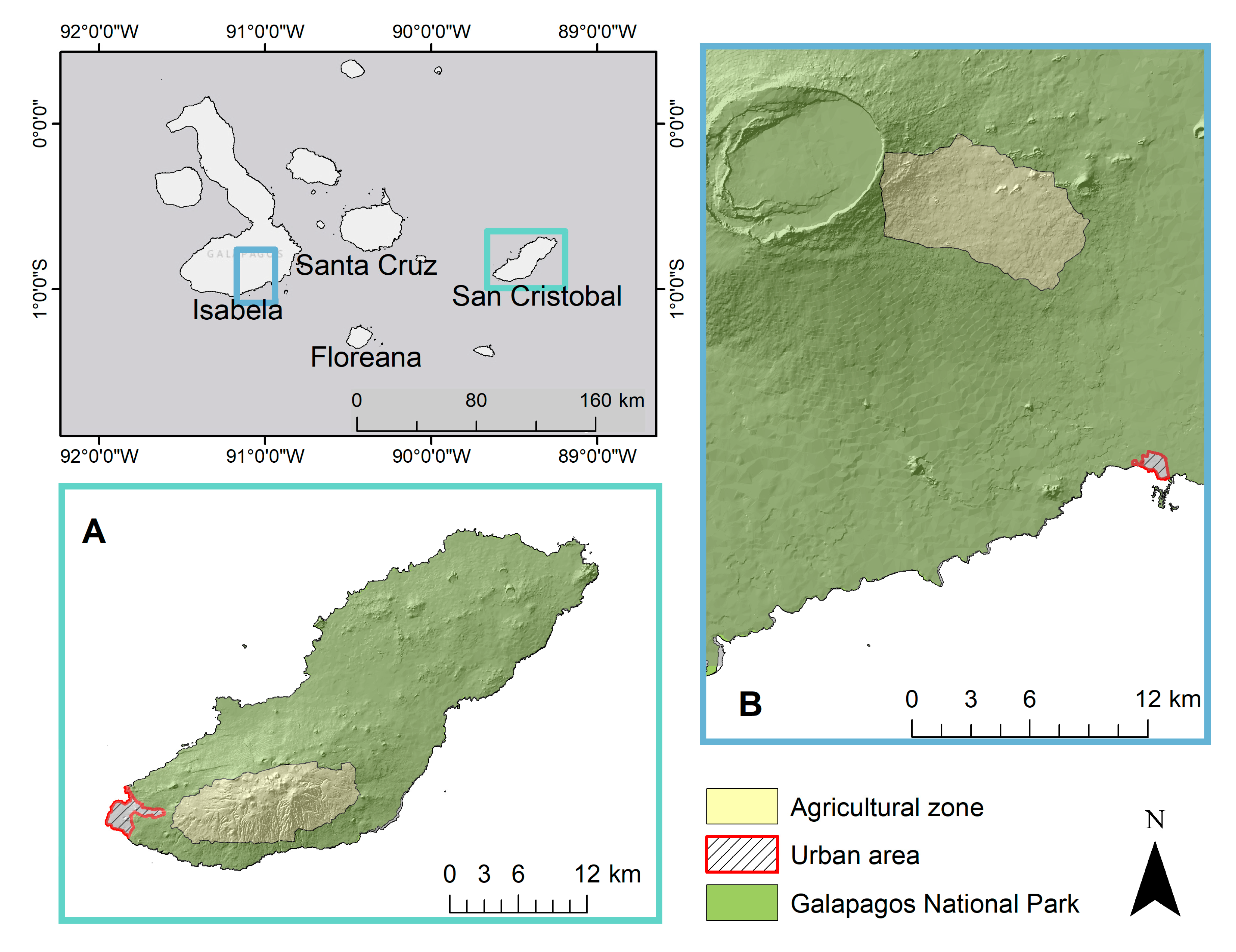
2.1. Study Area
All four inhabited islands of the Galapagos, Santa Cruz, San Cristobal, Isabela and Floreana, have a zone in the humid highlands that has been designated for agricultural use. The agricultural regions face the south or windward side of the islands, which receive high levels of precipitation during the warm season (January–May) and remain enveloped in clouds during the cool season (June–December) [
28]. Due to these environmental conditions, the highlands of the four inhabited Galapagos islands, Santa Cruz, San Cristobal, Isabela and Floreana, have been used for agricultural production since the early 1800s. During most of human history in the archipelago, agriculture was one of the inhabitants’ main economic engines and sources of food, and hundreds of alien plant species were intentionally introduced for this purpose [
29,
30,
31]. Today, the Galapagos National Park covers 97% of the terrestrial area (7.970 km
2) and agricultural activities take place in a fraction of the remaining non-protected 3%, completely surrounded by protected areas. Inhabitants of the agricultural areas of the Galapagos devote their land to three general activities: cattle ranching (bovine, poultry, pork), crop production (permanent and annual crops), and tourism activities. Invasive plants and pastures cover the majority of the land surface area of Galapagos agroecosystems (28.5% and 22%, respectively, [
13]).
This study is carried out on 22 farms on the islands of San Cristobal (
Figure 1a) and Isabela (
Figure 1b). Interviews used for this paper were conducted with farmers on San Cristobal and Isabela islands between June 2019 and July 2019. The study was reviewed and approved by the Institutional Review Board (IRB) of the University of North Carolina (IRB number 19-0940), and all interviewees participated with informed consent, under the condition that their oral interview responses would not be individually linked with personally identifying information such as the maps of their farms.
2.2. Participant Selection
Interviewees were identified by a variety of methods: directly due to existing contact information and relationships from previous visits; through friends, acquaintances, neighbors, and other third-party introductions; from visits to markets where interviewees sell products; by knocking on doors. We leveraged connections with known farmers to conduct further interviews and meet new interviewees. The majority of interviews took place on farms, though several were conducted in markets or in interviewee homes that were not at the same location as their farms. A total of 22 interviews were conducted during this period, 13 with farmers that had been visited during the previous year, and 9 with farmers that had not been visited previously.
2.3. Aerial Images
We conducted UAV flights, weather conditions permitting, on all farms that were visited regardless of whether or not there was existing aerial imagery. Dense fog and rain, which are frequent in the humid highlands, were the most common conditions preventing drone flights. UAV flights are used to compare land use management across years on the same property and also to help in classification of land cover. Flights from this set of interviews were conducted using Phantom 4 and Mavic Pro Platinum UAVs at an altitude ranging from 25 to 60m. We consulted with farmers about the boundaries of their property and built flight plans using Drone Deploy (version 4.7). Images were taken using a frontlap of 85% and sidelap of 75% to cover the entire farm evenly. Images were then stitched into an orthomosaic for the whole farm using Agisoft PhotoScan (version 1.4.5). If the farm was too large to be mapped in a single visit, we mapped the areas that farmers considered most significant, and areas that exhibited a diversity of land cover types. The images were formatted into a map layout in ArcMap (version 10.3) and printed on A3 paper.
2.4. Interview Methodologies
This study used three main types of interactions with farmers to gather information regarding their land management practices, opinions of agriculture on the islands, and current production practices. These interactions, detailed below, include
in-depth interviews,
farm tours, and interviews with orthomosaics created from UAV images (
aerial perspective interviews (API)). The interview method used at each site was chosen depending on available information and previous interactions with the farmers. The interviews conducted in 2019 build off of work done in previous years that predominantly used UAVs to map farmland in order to classify land cover and determine the spread of species across the highlands of the islands [
13]. Where UAV flights had already been carried out on farms, we were able to interview farmers using printed orthomosaics of their property from earlier visits. The main determining factor in the type of interaction with interviewees was whether aerial imagery of their farm existed. For new farms, we conducted in-depth interviews and farm tours. For farms for which we had aerial imagery, we printed orthomosaics and used them to conduct API.
2.4.1. Farm Tours
Each farm visit included a tour of the property led by the interviewee. While walking around the farm, we collected GPS points using a handheld GPS unit to mark notable features and specific crops and trees. This facilitated the classification of UAV imagery and provided another way to identify important places on the farm as dictated by the interviewee. Depending on the size of the property, farm tours generally included a tour of the perimeter of the property, however, for larger farms, the interviewee decided which pieces of the property were most important to see and focused the tour on those specific areas. It was common for both in-depth interviews and APIs to incorporate the farm tour as part of the interview process, as many respondents chose to show us in-person what they were referring to during our conversations. Farm tours were conducted regardless of the presence of UAV imagery and were repeated at farms where previous interviews and UAV flights had been conducted. In the event that interviews and UAV flights had been carried out on the property in previous years, the farm tour might just include changes to the property or show a part of the farm not included in the UAV images.
2.4.2. In-Depth Interviews
We used in-depth, semi-structured interviews conducted with farmers over the course of a farm visit using a framework of questions to understand the key production components and strategies used by the farmer. These interviews were predominantly conducted on-site at farms and set up beforehand by contacting farmers either at the farmer’s market, through neighbor introductions, or through contact information collected in earlier projects. Interviews, which were carried out by teams of two researchers, lasted 30 to 60 minutes and were conducted with anyone on the farm who felt comfortable participating in the interview (owners, full-time managers, spouses, etc.). In-depth interviews were often the first step in gathering information with farmers and done in conjunction with a farm tour, and were conducted on farms that did not have UAV imagery from previous years.
2.4.3. Aerial Perspective Interviews (API)
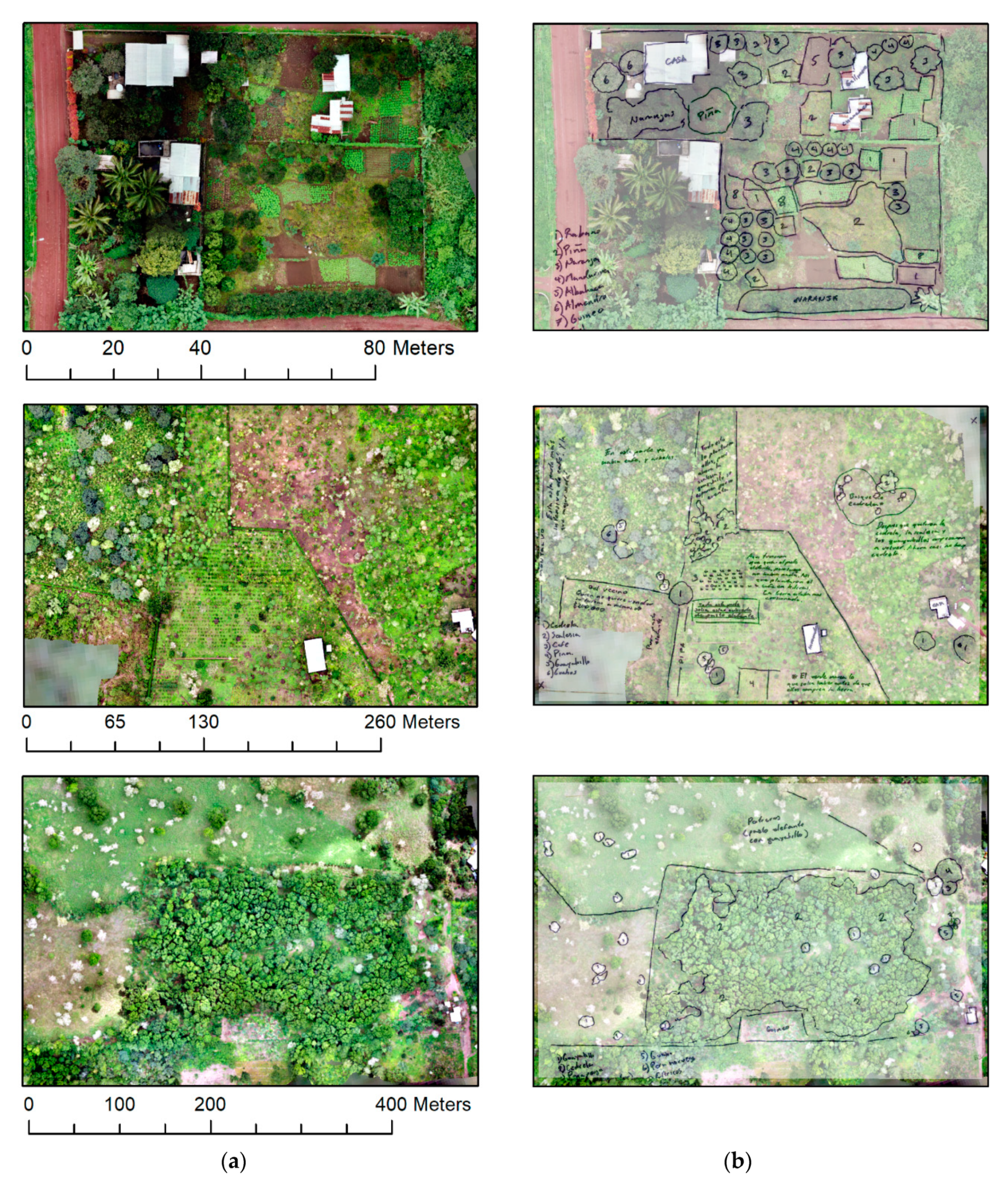
For farms where UAV flights had been conducted previously, we conducted interviews using a printed aerial map of the property. These interviews were conducted both on-site at farms or wherever we could arrange to meet with farmers, often at markets or their house if it was not on site at the farm. We based interviews on a framework of questions built on the assumption that interviewees were using the aerial image provided to guide the responses. These interviews used tracing paper to cover the aerial map, which could be illuminated from below using a lightbox. This allowed both interviewer and interviewee to draw or mark on the map as needed, as illustrated in
Figure 2. Depending on the comfort level of the interviewee, they were asked to indicate or mark on the tracing paper to outline different crops or trees, specific structures, and changes to the property, such as new structures, newly cleared areas, and crop rotations. Different colors were used to annotate elements that were currently visible in the image and those that used to exist on that same space. Most interviews using printed maps were conducted in one sitting and lasted 30-60 minutes. Some interviewees requested we bring the map as we toured their farm, often to help orient them to the aerial image more easily. At the conclusion of the API, interviewees were given the printed map to keep.
2.5. Interview Analysis
The process of analyzing these interviews involved coding each interview by topics discussed and comparing across interview types to examine how different interviews revealed different categories of answer. In order to make the resulting information accessible to typical research paradigms in the Galapagos, we classified the responses from our investigations using categories such as timber, livestock, invasive, tourism, animal interaction, history/change in land use, future, sense of space/place, cash crop vs. subsistence, and non-commercial value among other categories.
3. Results
Table 1 displays the interviews broken down by interviewee, type of interview, and size of farm. The largest category of farm size was less than five hectares and the majority of interviewees were male landowners, rather than property managers or laborers. Six out of 22 primary respondents were female and a total of three interviewees described themselves as farm managers or laborers for the property owner.
Coded interviews reveal the differences in responses from conducting different forms of interviews. Code categories include timber, livestock, economics, produce, management, tourism, and change.
Table 2 provides examples of types of responses in each coded category. The coded results are best compared within categories first, then looking across categories. These results demonstrate that, when looking at topics by number of mentions overall, API interviews mentioned change, management strategies, and produce more than in-depth interviews. On the other hand, in-depth interviews mentioned economics more than the API interviews.
Table 3 compares the total number of mentions of each of the topics from
Table 2 during both In-Depth and API interviews, as well as the number of In-Depth and API interviews that were coded for each of the topics listed.
4. Discussion
4.1. Comparison of Interview Methods
We observed differences in the three interview methods, which can be classified as differences in the themes of the open-ended discussions, differences in the logistics of the interviews, and differences in the perspective expressed by the farmer towards the land.
The significant differences in the themes discussed in API and in-depth interviews are highlighted in
Table 3. First, it is notable that a larger fraction of API interviews included at least one topic from our coding analysis; API interviews tended to correspond more to the topics of interest. The frequency of specific topics also varied between API and in-depth interviews, with significant differences between the number of mentions of bigger picture issues such as economics, land management practices and of changes in land use, land management, or overall management of the farm. Coding for management, which includes topics such as agricultural techniques, specific land management practices, and outside technical assistance, and for change, which included past changes and future plans for farms and agriculturalists, captures an idea about the big picture planning and ideas on each farm. During API, farmers were more likely to mention changes on their land or specific land management practices employed on their farms. It is also notable that these topics came up more frequently within the same conversation when using API than compared to in-depth interviews.
Both land tours and API could yield spatially explicit interview data, but API had several practical advantages over land tours in our qualitative research. Given that UAV flights had to be carried out for the quantitative land-cover analysis component of our overall study, the APIs allowed us to gather this spatially referenced information without being on the landholding. Interviews could take place at markets or in the farmer’s residence. Besides the convenience of meeting location, the API avoided the risk of damaging young crops or structures on the farm, which was a frequent concern during land tours.
We also noticed a difference between how people interact with their land (as it comes across in interviews) when presented with an aerial map versus walking around the land in person. When walking around someone’s land, the conversation often fixated on the exact plot of land on which we were standing. Farmers would explain what they were doing in that particular area when we were standing there. Whatever land we could see from where we were at the moment was often included in an explanation of the farm. Farmers would generally point to an area and we would move in that direction. If we asked a specific question pertaining to something on a different area of the farm, then the farmer would easily start talking about the other area. Similarly, if asked questions about changes in crops or land use, farmers would talk about whatever part of the farm they associated with the answer to the question. However, if asked to show us around and tell us about the land with no specific prompts, farmers often just talked about the land on which we were walking or the land we could see from wherever we were. In contrast, when we were talking with farmers over the aerial perspective maps, farmers often spoke about the land in a more interconnected way. We would hear explanations about why something was planted in one area and not another, with the farmer pointing out on the map why one area of land was used for a specific purpose and not a different area of land. Often without prompting, farmers would discuss the changes on their land over time, highlighting not only different crop production but also where they had cut down trees, moved animal enclosures, or added greenhouses.
4.2. Relevance for GIAHS Studies
With these differences between API and in-depth interviews in mind, we reviewed the literature focused on GIAHS to determine if the API interview methodology would be advantageous in understanding and preserving agricultural heritage. The criteria for selection as a GIAHS site requires that the agro-ecosystem contributes to livelihood and food security, maintains and supports a rich agrobiodiversity, utilizes traditional knowledge and technologies, demonstrates strong cultural values and collective forms of social organizations that support transmission of knowledge, and is situated within remarkable landscapes or seascapes [
2]. These criteria underline the idea that agricultural heritage sites have both a historical importance and a contemporary value, and are created through interactions of humans and ecology over long periods of time [
32]. Agricultural heritage systems are complex, with multiple subsystems and interdependencies embedded within them. As a result, there is a consistent message in the literature about research methodologies for agricultural heritage sites that emphasizes the importance of addressing GIAHS sites in their entirety and using a holistic approach that incorporates both the importance of biodiversity and recognizes the role of human activity in creating the agro-ecosystem [
32,
33]. Specifically, the scientific conceptual framework for the FAO GIAHS initiative emphasizes “collective understanding” among its 15 strategic principles, stating that “the GIAHS Programme must include scientific research at multiple scales which is conducive to social learning …[GIAHS monitoring] should be participatory and involve decision-makers at all levels” [
34].
In practice, research conducted in communities with agricultural heritage tends to focus on evaluating the biodiversity of the site and ways the site can be maintained and adapted to current contexts, or on the economic viability of agricultural practices going forward, examining both economic models and the potential for tourism to these sites in order to promote livelihood sustainability [
35,
36]. In the former case, the methods used to conduct research follow a general three-step structure of identifying boundaries and surrounding land use through satellite imagery analysis, conducting interviews with community leaders, farmers, and other key informants, and conducting in-person surveys to identify and confirm site characteristics and evaluate biodiversity [
37,
38].
From the existing literature, it is evident that, in order to conduct research related to agricultural heritage communities, a holistic approach encompassing methods that provide insight into both the human and ecological components of the system is essential. The coding categories of management, tourism, and economics all correspond to areas of interest in GIAHS research noted in the literature. While none of the reviewed literature discussed the importance of long-term relationships with GIAHS communities or the need for examining sites over extended periods of time, Santoro et al. [
38] did note that their data on land-use and agrobiodiversity in Tunisian mountain oases could be used as a baseline for comparing future changes and adaptations, suggesting the possible importance of a continued relationship with the GIAHS communities and interest in the system’s change over time.
We note that some of the differences in API interviews could be considered drawbacks in this context. While there was generally a bigger picture idea given about the farm while using the aerial images, it also seemed that we often lost out on some of the details that other farmers spoke about when we walked around their farms. It could be difficult to tell from the image what specific crop was growing on a certain plot of land. Farmers that were able to orient themselves to the maps quickly could identify specific trees or crops, but other farmers had trouble picking out specific land uses from looking at the aerial image.
4.3. Impact on Participatory Research Interactions
We found that API interviews affected the dynamic between the farmer and the interviewer. Using the maps and tracing paper introduced a new way for farmers to interact with and relate to their land. Farmers frequently commented on the beauty of their farms viewed in aerial perspective, and all of them were eager to keep the orthomosaics for themselves. However, there were moments of tension when certain farmers or people present at the conversation struggled to orient themselves or understand where they were in relation to what they were seeing on the map. Depending on how quickly someone was able to orient themselves, they tended to be more or less interested in using the aerial image as a way to explain their farm. On several occasions, the participants asked instead to show us around the farm rather than use the map. On these occasions, we brought the map with us as we walked across the land and could identify major landmarks, such as animal enclosures or greenhouses. As we walked and the farmer was able to demonstrate their knowledge of their land, they would often get more comfortable referring to the map to answer broader questions about changes in land use or decisions about planting.
Some farmers stated that the aerial image was valuable to them because it allowed them to “see” their hard work on the land. The fact that crops were visible from the air materialized their efforts for farmers, and they talked about the transitions that the land had undergone through time:
“First, as a woman in agriculture, [this image] elevates my self-esteem because I can see that mine is a job well done. This aerial view can show how well crops are doing. This [image] is also something that I can leave for future generations, as proof that in 2018 there were crops and trees inside the “urban zone,” as a “lung of Galapagos,” which I hope is maintained in the future. I do not want more houses built here. This image is also useful because I intend on reforesting even more. This image shows the “before” state. In the future, I will be able to see how it has changed”
(Interview, 21 July 2019)
The affirming power of their aerial images that farmers expressed was particularly pronounced for farmers who had struggled to transform large extents of land. For example, farmers would mention how entire sections of their farm used to be covered in weeds and invasive plants and were excited to see that their efforts to clear the land and plant with current crops or native tree species had paid off. As UAV technology is becoming more commonplace, farmers were already thinking about this image as part of a time series. They were excited to compare this orthomosaic with images that had been collected in the past or with images that they expected to collect in the future. Other farmers would use the image to orient visitors around their properties. Farmers with large and visually aesthetic properties sometimes receive tourists as part of their livelihoods, and they would use the aerial images to give tourists an overview of the property before the beginning of tours. Other farmers would use the image to plan new developments. The orthomosaics were used to estimate the size of planned constructions like greenhouses and water reservoirs. While most farmers found the aerial image useful and desirable to help them in their agricultural activities, one farmer with a small property said that this image was more valuable to them as a promotional tool because they were looking to sell their land. In short, interviews based on images like those in
Figure 2 represent a powerful tool for us as researchers to understand the landscape from the farmer’s perspective, but also can be an empowering tool for the farmer’s own goals and objectives.
5. Conclusions
Through combining interview methods, we are able to form a picture of the agricultural sector on the Galapagos islands that includes an understanding of land management practices, changes the farmers have observed or planned for, and the economic decisions farmers make. By incorporating in-depth interviews, farm tours, and API together with UAV flights, a more spatially oriented and thematically broader perspective of land and land management emerges. In the Galapagos, this provides an opportunity to further examine how farmers contribute to food production on the islands and how they manage invasive species on their land.
The methods used in this study are widely applicable, offering a new form of on-farm, participatory research that engages with participants through mapping. This approach differs from previous interview methods used in agroforestry and agricultural heritage research, such as community mapping, in the way it shapes relationships between the experts and the researchers, as well as between the spatial, temporal, quantitative and qualitative aspects of the data created. For example, due to the necessity of flying UAVs to capture images in order to create orthomosaics to use in APIs, longer-term relationships are integral to the method of APIs. This provides more opportunities to focus on changes in landscapes or land management, as we expect that revisiting sites with orthomosaics from previous years will provide the interviewee with a different perspective, both spatially and temporally, than they are accustomed to interacting with. The annotated images from APIs may be useful to agricultural heritage communities for planning, outreach, and for communicating land use and land tenure. Additionally, since UAVs providing geographically precise information are incorporated in the API process, opportunities to use the orthomosaics for other forms of analysis presents greater possibilities of combining qualitative data with quantitative analysis of the UAV imagery.
Combining in-depth interviews, farm tours, and API present a unique set of interview methods for understanding the different perspectives of any landscape that is under pressure. These methods are adaptable to use in conditions where little is known about how people view and manage their land across different physical geographies. The use of API methods is particularly applicable to agricultural heritage research, agroforestry practices, and other fields where collecting on-farm research and engaging farmer participation in the collection of qualitative data is important for understanding perceptions of climate change, conservation practices, and the relationship between farmer and land.


