Review

UAS-Based Archaeological Remote Sensing: Review, Meta-Analysis and State-of-the-Art

by
Efstathios Adamopoulos
1,* and
Fulvio Rinaudo
2
1
Dipartimento di Informatica, Università degli Studi di Torino, Corso Svizzera 185, 10149 Torino, Italy
2
Politecnico di Torino—DAD, Viale P.A. Mattioli, 39, 10125 Torino, Italy
*
Author to whom correspondence should be addressed.
Drones 2020, 4(3), 46; https://doi.org/10.3390/drones4030046
Submission received: 6 August 2020 / Revised: 17 August 2020 / Accepted: 17 August 2020 / Published: 19 August 2020

Abstract

:
Over the last decade, we have witnessed momentous technological developments in unmanned aircraft systems (UAS) and in lightweight sensors operating at various wavelengths, at and beyond the visible spectrum, which can be integrated with unmanned aerial platforms. These innovations have made feasible close-range and high-resolution remote sensing for numerous archaeological applications, including documentation, prospection, and monitoring bridging the gap between satellite, high-altitude airborne, and terrestrial sensing of historical sites and landscapes. In this article, we track the progress made so far, by systematically reviewing the literature relevant to the combined use of UAS platforms with visible, infrared, multi-spectral, hyper-spectral, laser, and radar sensors to reveal archaeological features otherwise invisible to archaeologists with applied non-destructive techniques. We review, specific applications and their global distribution, as well as commonly used platforms, sensors, and data-processing workflows. Furthermore, we identify the contemporary state-of-the-art and discuss the challenges that have already been overcome, and those that have not, to propose suggestions for future research.

1. Introduction

In the past decade, substantial technological progress has been recorded in the manufacturing of unmanned aerial platforms and affordable lightweight active and passive sensing devices, and the integration of microelectronics. Benefiting from the above, remotely controlled integrated sensing systems, which do not require an on-board crew, are being continuously miniaturized and have become widely accessible for commercial use. The development of integrated unmanned aircraft system (UAS)-based solutions is increasingly providing researchers with means to capture remote sensing data for archaeological applications, at spectral, spatial, and temporal resolutions not achievable with satellite or manned systems. UAS-based data collection is consistently becoming cost-effective given the unprecedented increase of precision and accuracy, and the ever-present capacity to cover vast, often inaccessible historical sites, of varying topographical characteristics with shorter flights and with less time-consuming acquisition planning. Thus, implementations of UAS for archaeology aim to fill in the existing gap between satellite/airborne sensing and terrestrial archaeological investigations.
The scope and spatiotemporal characteristics of an archaeological application are determinant for the optimal combination of platforms, sensing payloads, and processing techniques. This paper aims to present a comprehensive survey of the archaeological UAS-based remote sensing approaches reported in recent literature and gives a detailed account of the current state-of-the-art on relevant sensors, integrated payloads, and aerial platforms. The conducted research tracks the integration of technological advancements made during the last decade—on uncrewed platforms, lightweight sensors, and post-processing techniques—in UAS-based remote-sensing archaeological activities, in order to identify occurred opportunities and challenges and to express future perspectives.

Organization of the Article

This paper provides a systematic review and meta-analysis of UAS-based hardware, software, and data analysis scenarios relevant to archaeological applications of remote sensing. Section 2 provides a brief overview of the development of archaeological remote sensing and identifies the problems for which UAS-based data collection is called to provide solutions. Section 3 addresses the methodology of the presented survey. Section 4 describes and analyzes the results of the systematic review. Specifically, Section 4.1 reports on utilized platforms, Section 4.2 on navigation parameters, Section 4.3 on sensors, and Section 4.4 on the reported cases of the applied archaeological remote sensing, and the relevant data products. Section 5 discusses the current state-of-the-art regarding UAS-based remote sensing. Finally, Section 6 presents some concluding remarks and perspectives.

2. Background

Traditional aerial imagery—produced with optical sensors—has proven to be beneficial to many archaeological applications. For more than eight decades, it has systematically provided an effective solution for settlement and landscape archaeology [1,2,3], which has recently been combined with other non-destructive archaeological methods [4,5,6,7]. Aerial RGB imaging has been implemented in different scenarios to identify earthworks and remains that are still just observable above the ground level: by exploiting the differential shadow and highlight effects when the sun is low in the sky, the effects of melting snow and widespread flooding, as well as the existence of positive/negative cropmarks and soilmarks through identifying color differentiation from the surroundings [8,9].
Archaeological remote- (and close-range) sensing activities, especially concerning fully buried historical remains, depend considerably on the quantization of the contrast within their immediate context, which is often not found at the visible (VIS) spectrum. Since archaeological remains do not present spectral signatures useful for generic detection applications, it is hypothesized that they exhibit localized contrasts in the landscape matrix, detectable using suitable sensors under appropriate environmental conditions. The measurement of the desired contrast can be realized directly, when there are detectable topographic effects, or indirectly, when variations of vegetation, magnetic fields, electrical properties, thermal behavior, or spectral reflectance exist [10,11,12,13].
Airborne light detection and ranging (LiDAR) has emerged as a prevalent active remote sensing technique for the direct measurement of the effects that close-to-surface buried archaeological remains have on the topography of a landscape. Laser-based sensors are capable of providing the needed primary data for detailed digital terrain and surface models (DTM, DSM) over vast landscapes, which, if subjected to appropriate artificial hill-shading, can assist the interpretation of significantly more features than with original aerial surveys [14,15]. Furthermore, LiDAR has the ability to penetrate foliage, making it particularly useful for vegetated landscapes, such as tropical regions where rapid vegetative growth can obscure the microtopography of archaeologically rich terrain [16,17]. The artificially shaded visualization of LiDAR-produced DTMs or (the unfiltered from canopy) DSMs, which has been explored according to slope, aspect, principal component analysis (PCA), local relief modeling (LRM), sky-view factor (SVF), and trend removal [18,19] can further increase the visibility of archaeological features.
The detection of the landscape matrix contrast that can indirectly provide interpretations of archaeological significance, requires data from various small components of the electromagnetic spectrum, making multi-spectral and hyperspectral-sensor approaches particularly pertinent for comprehensive surveys. Towards this end, satellite imaging has contributed significantly to archaeological research since high-resolution satellite datasets became available for commercial use [20,21,22]. The level of difference between the electromagnetic energy reflected and/or emitted from a feature and the background energy—as registered by the multi-spectral or hyperspectral sensor—determines the successful location and analysis of the feature [23]. The main techniques used in archaeology for the analysis of multi-spectral imagery are visual interpretation, false color composite visualizations, vegetation and soil indices, thresholding, classification, PCA, filtering, and Geographic Information Systems (GIS) [20,23,24]. Occasionally, airborne multisensory apparatuses have been involved for archaeological surveys to simulate multiwavelength imagery acquired from satellite-based sensors [25,26,27]. Aerial thermography, to an extent, has also been employed for archaeological remote sensing [28,29] for the detection of measurably distinct variations between the features and the soil matrix in which they are embedded. Furthermore, case studies of archaeological aerial thermography with higher spatial and spectral resolution sensors have been recently reported [30,31].
Satellite and manned aircraft system-based remote sensing includes expensive platforms, which are significantly restrictive due to availability limitations and/or complex logistics. Moreover, satellite, and airborne imaging and LiDAR, come with noteworthy drawbacks concerning spatial and temporal resolution, and the flexibility of data acquisition [32,33]. Low-altitude nadiral photography, as an alternative to satellite and airborne-sensing approaches, has a long tradition of implementation for archaeological applications employing unmanned aerial platforms [34,35,36], with notably varying capabilities, maximum payloads, working heights, optimal operation conditions and flexibility.
The recent technological developments in UAS-borne integrated multi-sensor systems have provided us with powerful solutions for archaeological sensing, with enhanced maneuverability, spectral range, data precision, and navigational accuracy [37,38,39]. Compared to manned aerial platforms, unmanned aircraft can generally be operated with higher consistency and stability, under varying conditions and over a plethora of topographies [40,41,42,43]. Therefore, they are called to bridge the gap between satellite, airborne and terrestrial techniques in terms of spatial and temporal resolution, and to provide easy-to-use solutions for a variety of heritage specialists [44,45,46]. After almost a decade of UAS-based archaeological remote sensing, it is an opportune time to review the platforms, the payloads, and the processing techniques involved so far over various applications, and to record the current state-of-the-art at the turn of the new decade.

3. Methodology

3.1. Article Selection Method

To complete the presented review and meta-analysis a thorough literature search was undertaken on UAS-based applications for archaeological remote sensing up to 18th June 2020, in line with related studies [47,48]. The search was done using the Google Scholar platform, and produced 272 results. Keywords for the search included drones in their various meanings and acronyms: “unmanned aircraft system”, “unmanned aerial system”, “UAS”, “unmanned aerial vehicle” [UAV], “uncrewed aerial vehicle”, “UAV”, “remotely piloted aerial system”, “RPAS”, “drone”. These were combined with terms referring to sensing, sensors, and typical archaeological applications: “remote sensing”, “low-altitude sensing”, “near-infrared”, “thermal”, “multi-spectral”, “hyperspectral”, “laser scanner”, “LiDAR”, “GPR” [ground-penetrating radar], “photogrammetry”, “heritage”, “archaeology”, “archaeological site”, “archaeological landscape”, “archaeological remains”, “buried remains”, “historical landscape”, “archaeological prospection”, and “heritage diagnostics”. In total, 65 combinations were applied using logical disjunctions. This was further complemented through reference harvesting, citation tracking, choosing abstracts from relevant conference programs, and author search using Scopus and ResearchGate, which produced an additional 30 records.
Duplicate results and results that were insufficiently relevant to archaeological research were removed, which reduced the number of results to 231. The publications were collated and revised accordingly, after full-manuscript reading (see PRISMA flowchart in Supplementary Figure S1 checklist). The initial results were filtered according to document type. Peer-reviewed publications not reporting the use of UAS platforms or reporting the use of UAS-based imaging only as a complementary documentation means for satellite/airborne sensing were not considered. It should be highlighted that the current study also did not consider applications of metric or non-metric documentation surveys that were purposed for merely creating three-dimensional (3D) photorealistic records of archaeological remains. Therefore, articles reporting this typology of studies were discarded. Furthermore, peer-reviewed publications that solely reported the use of images as-shot with no post-processing taking place were also discarded. The final list of selected publications consisted of 68 records related to UAS-based archaeological remote-sensing applications, reporting 78 distinct studies (meaning morphologically vastly different sites or the implementation of different survey workflows). The final list included 45 journal articles, 12 conference proceedings papers, and one book chapter (see Supplementary File S2).

3.2. Content Meta-Analysis

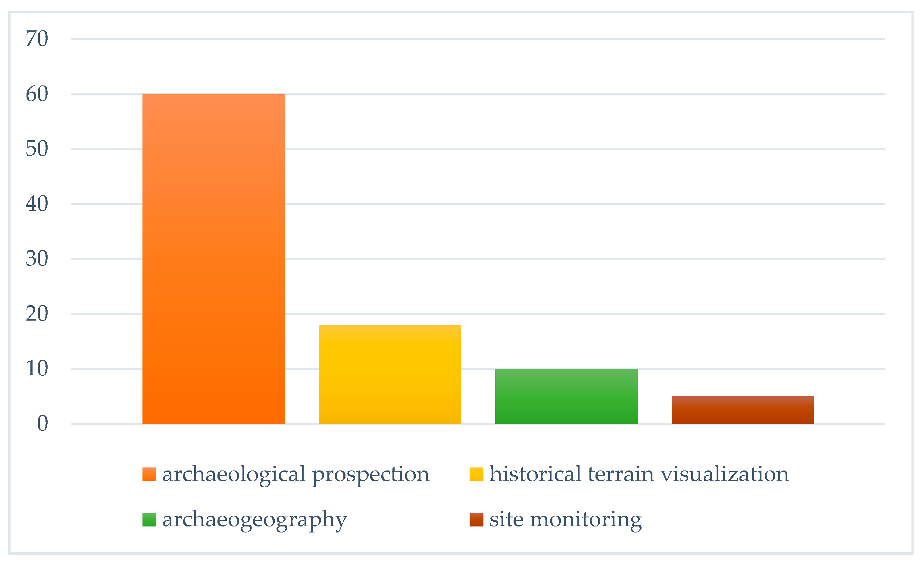
The studies were classified into four categories that correspond to representative archaeological remote-sensing fields. The categories are: “archaeological prospection” for studies aimed at the detection of buried archaeological remains either by direct sensing of their properties, or by measuring the contrast within their immediate landscape matrix (number = 60); “historical terrain visualization” for applications related to digitally enhancing the visibility of observable above ground archaeological features such as previously unburied remains, earthworks or geoglyphs, and of their immediate surroundings (number = 18); “archaeogeography” for studies directed towards analyzing the detected archaeological features—beyond plain visualization—by defining their geospatial relations (number = 7); “site monitoring” for those investigations aimed at monitoring historical landscapes and uncovering their natural or human-induced historical transformations through time (number = 4). For a few cases, an overlap was observed (number = 15), meaning simultaneous use of the same UAS-based equipment for more than one archaeological purpose, with different platform configurations, or by exploiting multiple data-processing scenarios.
For the meta-analysis, various parameters were catalogued, regarding the 78 documented studies, which are fundamental to UAS-based archaeological remote-sensing applications. These parameters for every study were: publication title, year, number of citations, thematic category, number of sensors by type, total number of sensors, sensor brand and model, number of platforms, platform type, platform brand and model, autopilot model, navigation system, flight planning software, type of processing results, spatial resolution of data, complementary terrestrial aerial or satellite sensing techniques used, and study area location. After documenting the significant parameters for each study in a spreadsheet, we performed in-depth data cleaning and confirmed the values of the designated parameters to guarantee data quality and correctness. We performed exploratory analyses using column plots to determine if any trends were evident, regarding UAS-based data acquisitions and processing workflows, in archaeological remote sensing. We were primarily interested in determining the correlations between platforms, sensors, typologies of archaeological terrain, application scenarios, and categories of results obtained.

3.3. State-of-the-Art Survey

In addition to the meta-analysis, we performed a survey of the state-of-the-art of standalone sensors, integrated payloads, and ready-to-fly UAS, available at the time of our review, purposed for archaeological remote-sensing surveys. We also included integrated aerial systems manufactured for other applications—mainly for precision agriculture and infrastructure inspection/monitoring—which can adequately be used for the topics discussed in this paper without additional modifications.

4. Meta-Analysis Results and Discussion

The 68 identified publications [49,50,51,52,53,54,55,56,57,58,59,60,61,62,63,64,65,66,67,68,69,70,71,72,73,74,75,76,77,78,79,80,81,82,83,84,85,86,87,88,89,90,91,92,93,94,95,96,97,98,99,100,101,102,103,104,105,106,107,108,109,110,111,112,113,114,115,116] related to UAS-based archaeological remote sensing, were published between 2012 and 18 June 2020 in 36 different publications/journals. Collectively the International Society of Photogrammetry and Remote Sensing has published 9 articles (~13.2% of the total number of analyzed publications), under the International Archives of the Photogrammetry, Remote Sensing and Spatial Information Sciences, ISPRS Annals of Photogrammetry, Remote Sensing and Spatial Information Sciences, and ISPRS International Journal of Geo-Information. The WILEY journal Archaeological Prospection published the largest number of articles (8), while Elsevier’s Journal of Archaeological Science: Reports published 5 and MDPI’s 
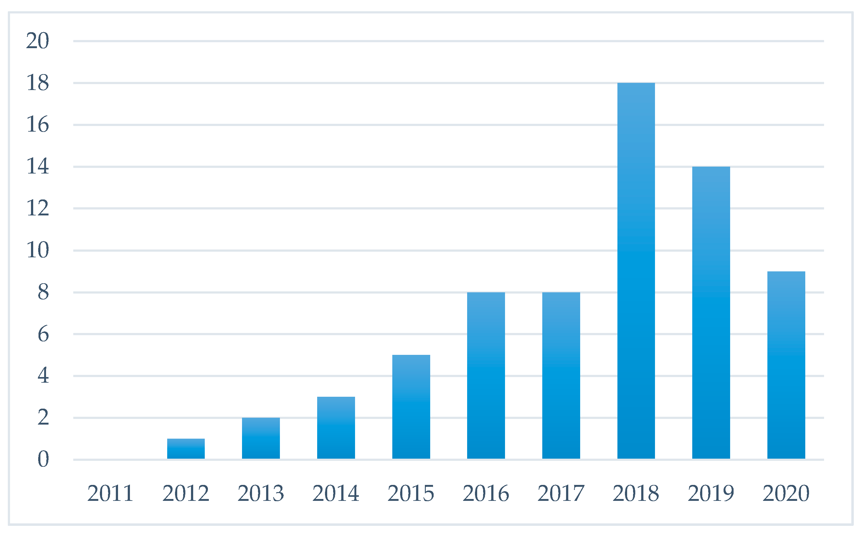
Remote Sensing published 4. The trend in publication had increased each year steadily, until 2018, with the maximum growth in the number of articles published observed between 2017 and 2018 (Figure 1). Citation information derived from Google Scholar shows that the average number of times each publication has been cited is 9.2, with a minimum of 0, a maximum of 84 ([55] published in Journal of Archaeological Science), and a median of 3. Archaeological prospection related applications accounted for ~77% of the documented studies, while much smaller numbers were observed for the other types of applications, ~23% for historical terrain visualization, ~13% for archaeogeography, and ~6% for site monitoring applications (Figure 2). Nevertheless, the studies included in the meta-analysis covered a wide range of archaeological contexts and, broad geographic extent.
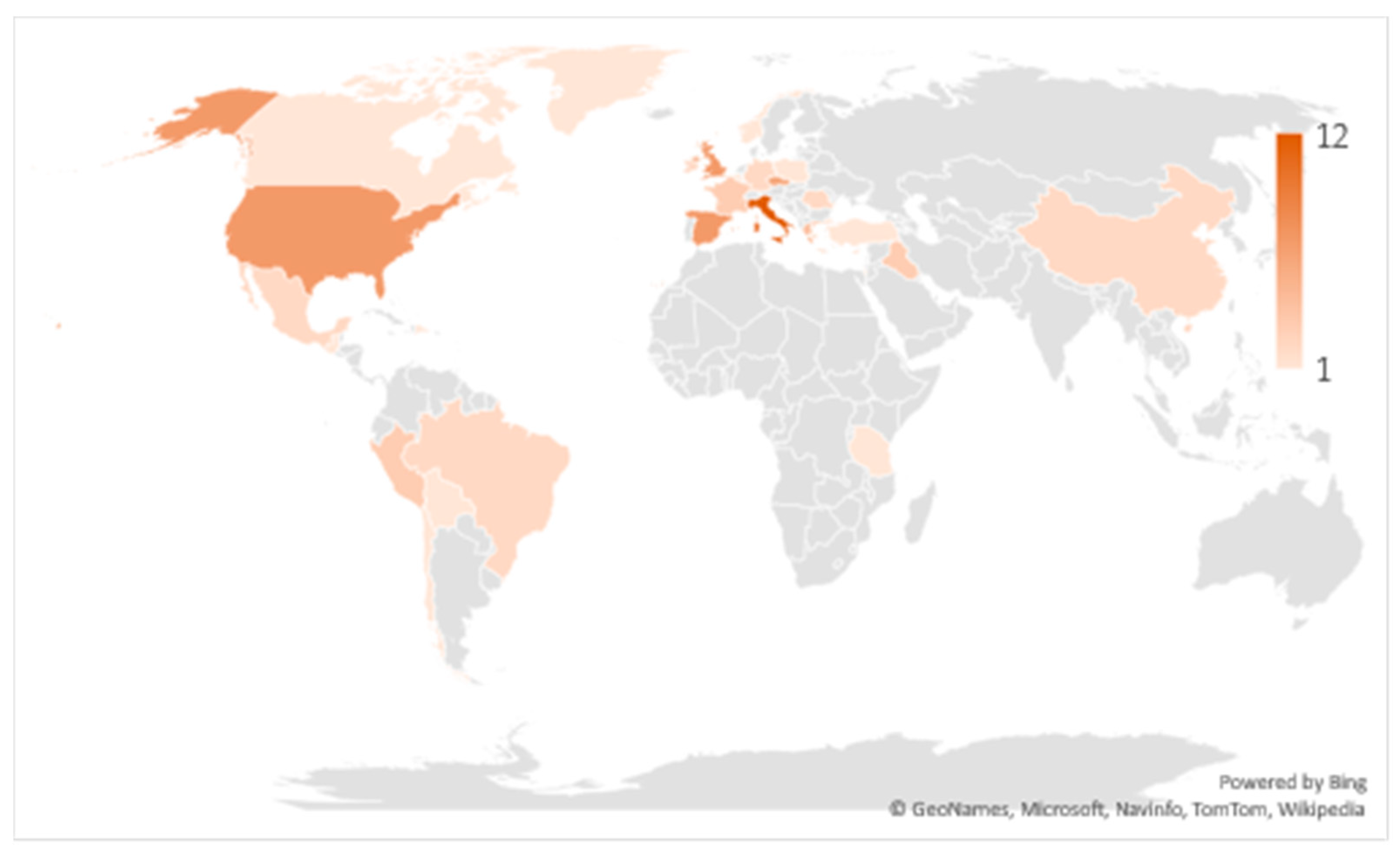
Study locations were mapped from the 68 publications, and it was found that UAS have been employed in applied archaeological remote sensing across the world with primary clusters of activity in Europe and North America (Figure 3). A secondary cluster was observed around the tropical countries of Central and South America where dense canopy is obscuring the rich archaeological landscapes and, therefore, increasingly more studies are taking place to reveal and to visualize the hidden historical terrains. Italy leads the ranking of countries where UAS-based archaeological studies have taken place (12), followed by Spain (7), the United States of America (7), Czech Republic (6), the United Kingdom (6), and Greece (4).

4.1. Platforms

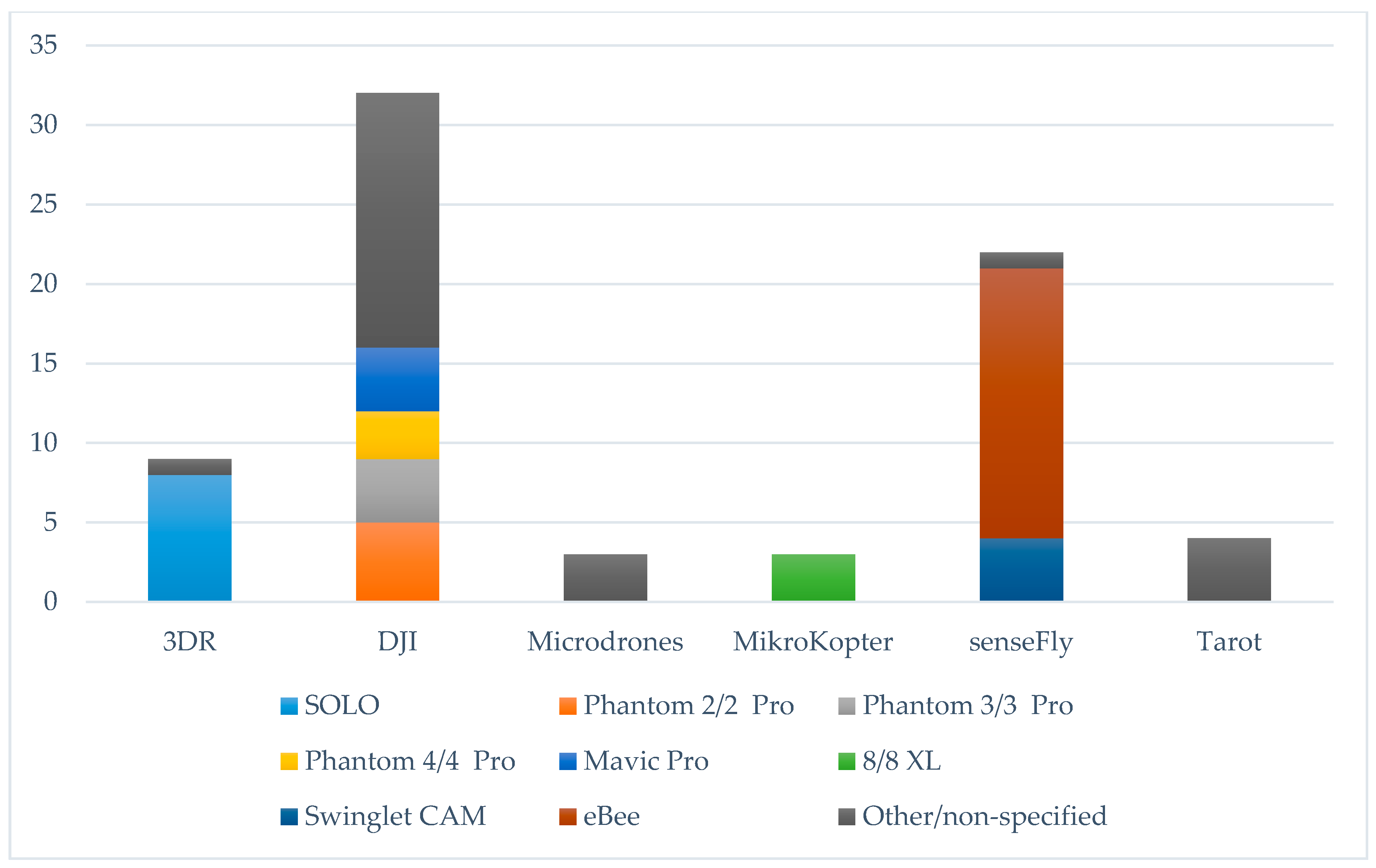
The majority of studies (60) reported using multirotor-style platforms, which can be attributed to easier maneuverability, higher stability, and the capacity to carry heavier payloads with smaller platform size-to-payload ratios. Only 27 studies reported the use of fixed-wing platforms. In total, 91 platforms were involved in the studies, of which 27 were fixed-wing, 42 quadcopters, 12 hexacopters, and 14 octocopters (circle-shaped, v-shaped, and X8 rotor configurations). The most commonly used platform (Figure 4) was the senseFly eBee, a fixed-wing platform which can be purchased around $25,000 USD with real-time kinematic (RTK) positioning enabled and a SODA 20 MP RGB camera, has a maximum flight time of 50 m, 33 km flight range and optional multi-spectral and thermal sensors available. Other popular choices included the DJI Phantoms and the (discontinued) 3DR SOLO. A few studies reported the use of a custom made platform.

4.2. Navigation

A high percentage of the UAS (at least 70%) used for the analyzed studies, and specifically those manufactured by DJI, Microdrones, and senseFly, were ready-to-fly and, therefore, pre-equipped with an autopilot system for navigation control. Of the studies using not ready-to-fly UAS systems, only a few reported the utilized model of autopilot, with Ardupilot APM, Pixhawk, DJI Naza, and the MikroKopter Flight-Ctrl series appearing more often. Similarly, regarding on-platform hybrid measurement units/hybrid navigation system (HMU/HNS), most platforms were already pre-equipped, and only 2 of the studies utilizing non-pre-integrated navigation units [110,112] reported which models were involved; namely an Applanix APX-15 and a NovAtel SPAN-IGM-S1. Most studies (55) reported the use of flight planning software, and only 5 reported performing manual flights, while for the majority of the rest of the studies—that did not report about this matter—it was assumed that flight planning software was used, according to the description of the acquired datasets. The MikroKopter Tool, Pix4Dcapture app, senseFly eMotion, and the free, open-source ArduPilot Mission Planner were the ones encountered more often.

4.3. Sensors

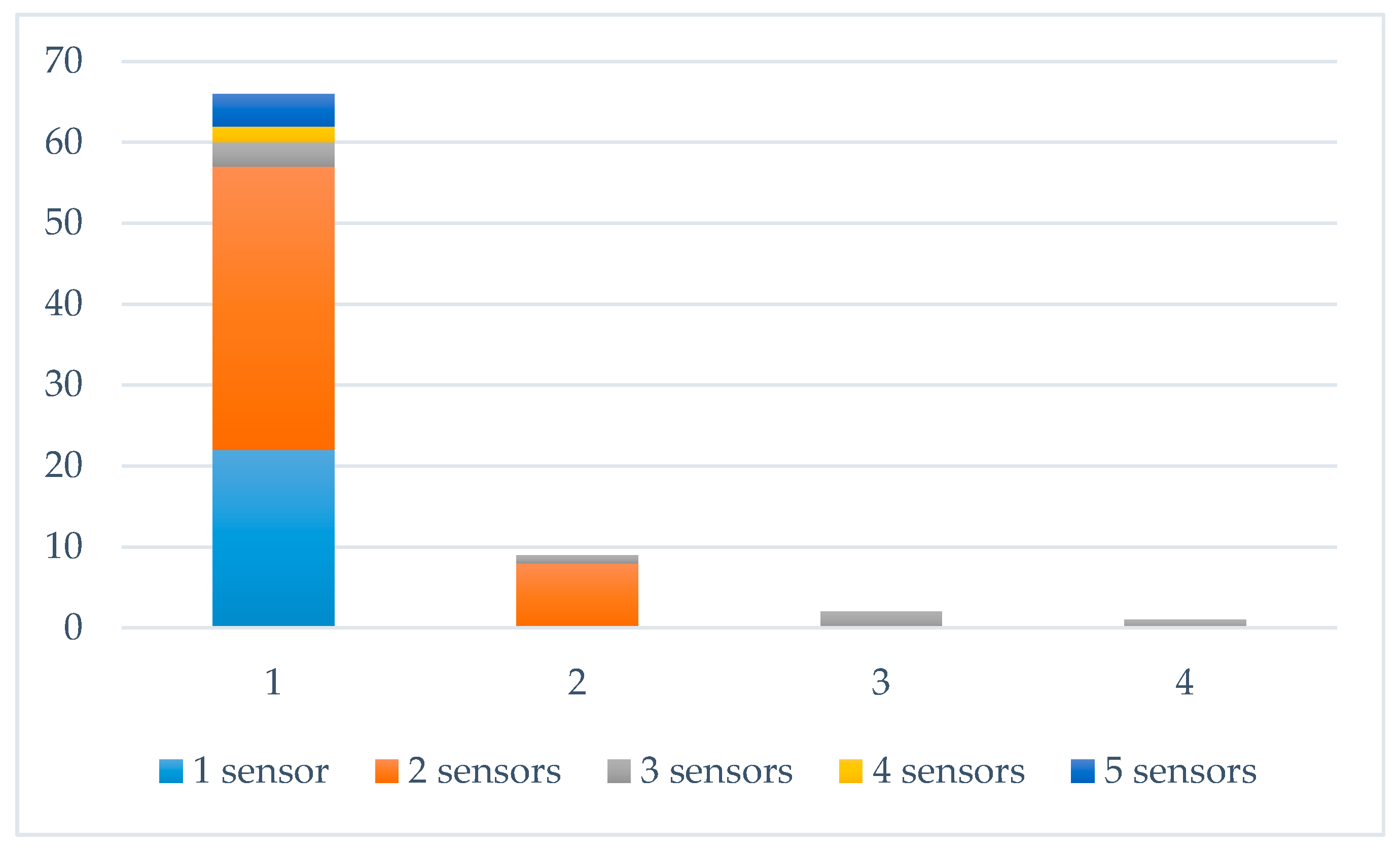
Significantly, 56 studies reported the utilization of multiple sensors, and 12 studies also reported employing multiple platforms (
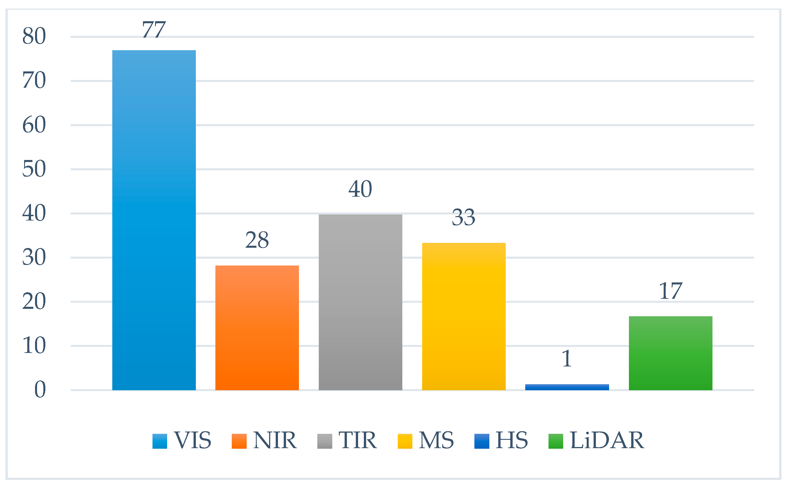
Figure 5). Ten studies used LiDAR sensors, 22 studies used near-infrared (NIR) cameras, 31 studies used thermal-infrared (TIR) cameras, 26 used multi-spectral cameras (MS), and a single study used a hyperspectral (HS) camera (Figure 6). Studies overwhelmingly used pre-equipped or off-the-shelf red, green and blue (RGB) cameras (77%), mainly in combination with other sensors. Canon cameras were a popular choice (used for 31% of the total studies), as 17 studies used Canon off-the-self cameras for RGB acquisition, while 16 studies used Canon cameras for NIR acquisition after they were subjected to a modification in order to be sensitive only in a portion of the NIR spectrum.
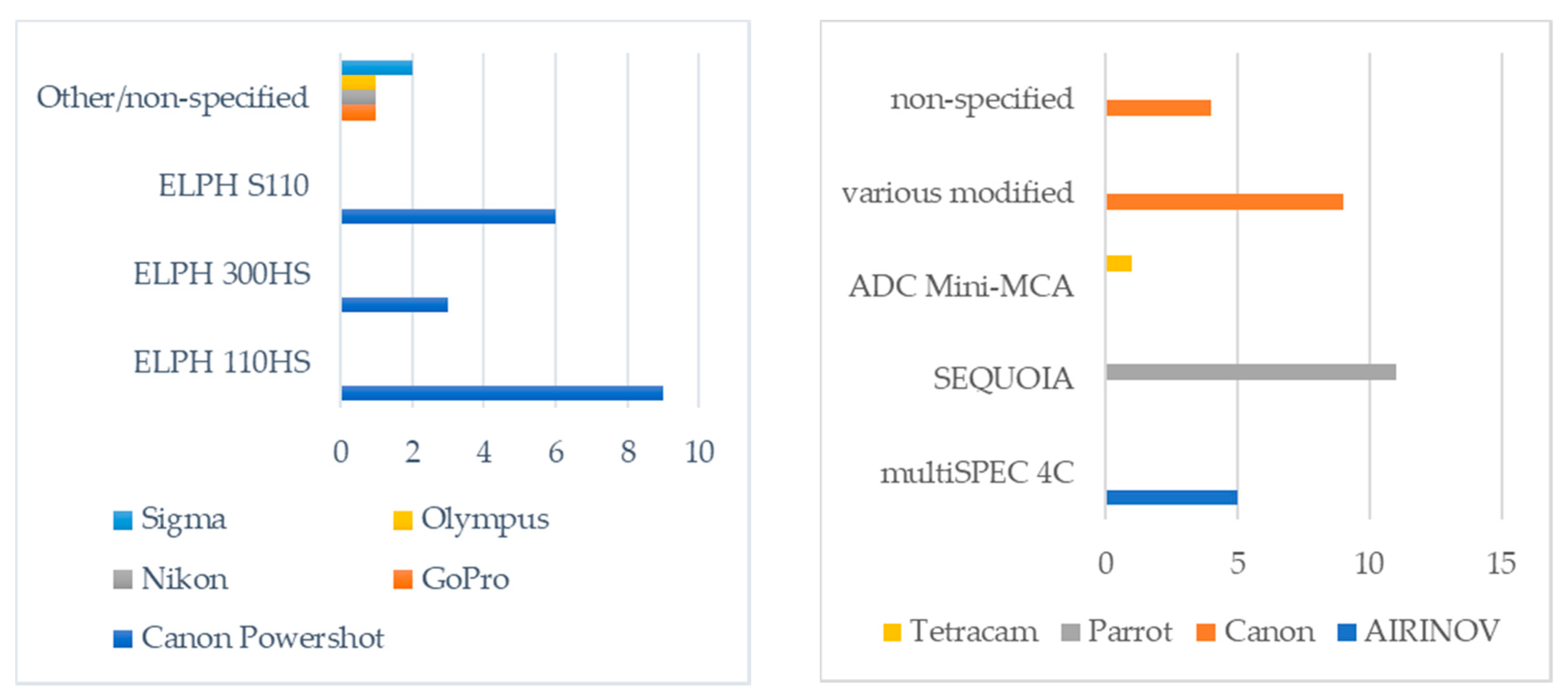
All reported NIR data acquisitions were performed with commercial digital cameras (digital-single-reflex, compact, and action cameras), modified by either the manufacturer of the UAS platform or the researchers. Canon PowerShot ELPH 110HS, PowerShot ELPH 300HS, and PowerShot ELPH S110 were the most frequently used cameras modified for NIR imaging (Figure 7–left). The most recurrently used MS camera was the Parrot Sequoia (11 studies), whereas modified Canon cameras were used in 9 studies, the AIRINOV Multispec4C was used in 5 studies, and the Tetracam ADC Mini-MCA and the MAPIR Survey2 cameras were each reportedly used once (
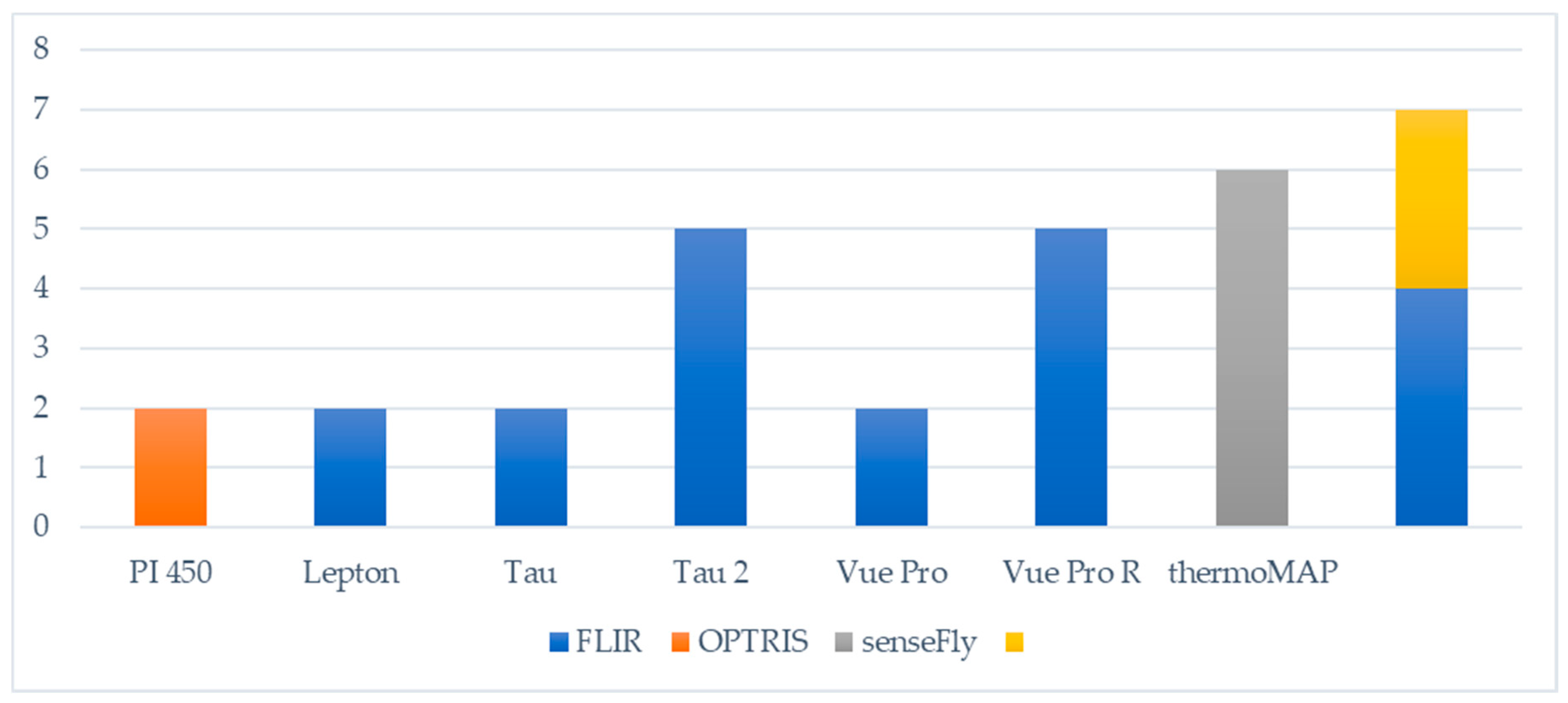
Figure 7–right). Regarding TIR sensors, 16 FLIR-manufactured cameras purposed for UAS integration were reported, but the senseFly thermoMAP was the most popular thermo-camera solution (Figure 8). Most studies captured imagery with nadir—or near nadir—facing cameras; only a handful of studies stated they captured oblique imagery.
Amongst the miniaturized LiDAR solutions, the Riegl VUX-1UAV and Velodyne VLP-16 were the most used, each having been utilized three times. Furthermore, the Riegl miniVUX-1UAV, the Sparkfunk LiDAR-Lite V2, and the Yellowscan Mapper were used once, while there were also two unreported LiDAR sensors involved in the recorded studies.

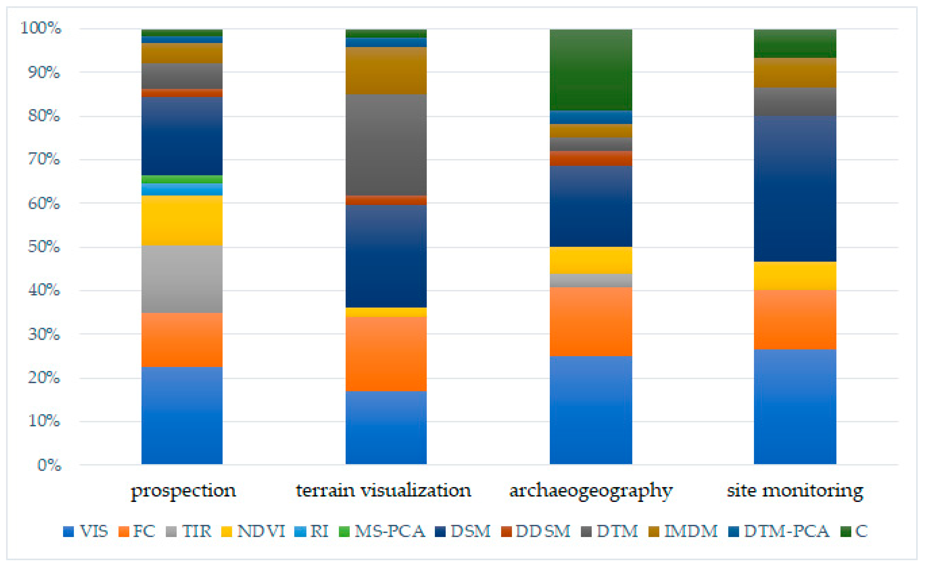
4.4. Data Products and Applications

A major part of the recorded UAS-based archaeological prospection activities involved the interpretation of visible spectrum orthophotos/orthophoto-mosaics (68%) and DSMs (55%; for relative percentages see Figure 9), which were mainly produced using structure-from-motion (SfM) and multiple-view-stereo (MVS) approaches. The level of involvement of these products in archaeology can be explained by the high level of automation achieved in the last years, which allows almost automated mapping workflows—from acquisition to analysis of mapping results—for archaeological applications. Flight planning, pre-processing of the images, image-based modeling, production of digital elevation models (DEMs), production of visible, thermal and index maps, and point cloud and image classifications can be realized using the same workstation and software, with minimal interventions, even in real-time. Studies overwhelmingly utilized the Pix4D software platform as an integrated solution to capture imagery datasets (through the mobile application) and create digital models or orthoimages for classification and analysis. Agisoft PhotoScan/Metashape and ArcGIS have also been implemented in a handful of studies for the digitization and analysis procedures, respectively. Visible orthoimages were commonly exploited towards the manual identification of crop-marks and the integration with results acquired from other spectra to acquire false-color composites. Brooke and Clutterbuck [52] reported an innovative image-enhancing approach using visible spectrum orthophotos; they used Wallis color filtering to increase local contrasts between buried masonry and grass. Additionally, Masini et al. [81] performed multi-temporal investigations to compare negative cropmarks, positive cropmarks, grass marks, and damp marks caused by buried remains. DSMs were interpreted without additional processing in many studies. However, De Reu et al. [72] and Šedina et al. [101] used multitemporal DSMs to construct differential digital surface models (DDSMs), and monitor change over excavated archaeological sites and crop marks, respectively. Several studies exploited the DSM products for interpretative mapping of the archaeological features through PCA and artificial shading [61,63,72,79,88,89,96,97,100,101].
False-color and TIR-orthoimages appeared often in prospections studies (37%, and 47% of the prospection studies respectively). False-color multichannel composites were produced either by using the MS datasets for image-based modeling directly or by combining overlapping orthoimages of different wavelengths. Most MS composites where either reduced through PCA [50,84,109] or processed for normalized difference vegetation index (NDVI) mapping [50,52,54,56,57,60,66,67,68,70,71,72,75,76,84,85,86,97,99,104,109], in order to enhance the contrast between the proxies of buried remains and the landscape matrix. It is worth mentioning that a few studies [50,60,75,86,97,99] reported the use of multiple radiometric vegetation and soil indices to identify which wavelength combinations maximized the local contrasts. Another notable finding was that all thermal investigations were purposed towards archaeological prospection activities. Multi-temporal thermal acquisitions often appeared in the analyzed studies. At the same time, McLeester et al. [84] also pointed out how thermal orthoimages have to be corrected through several steps—from stripping caused by the TIR camera’s periodic self-calibration and the thermal sensor’s temperature variations during acquisition—to accurately extract temperature information. Lastly, few prospection studies also reported the use of DTMs to identify topographic reliefs caused by buried historical remains [58,59,73,93,96,98,112]
Activities referring to the accurate visualization of archaeologically rich terrain with UAS-assisted approaches have either explored the use of DSMs or DTMs. While DSMs have been mainly produced with SfM/MVS image-based approaches, DTMs of vegetated areas have been exclusively produced with miniaturized LiDAR sensors [87,96,98,110] or by filtering 3D point clouds derived from image-based modeling with NIR imagery datasets, before constructing the terrain model [49,106]. To a lesser extent, the visualization of historical terrains towards the better interpretation of historical landscapes has been explored in the bibliography by interpretative mapping techniques [65,88,96,100].
In UAS-based archaeogeography applications, the rectified images, ortho-mosaics and raster elevation images have been used in a great extent, and analyzed through classification and shape analysis techniques, to interpret the shape of historical structures [110], the distribution of historical [69] and traditional structures [78], buried remains [77,85], and archaeological artifacts [74,114,116].
Lastly, five applications relevant to UAS-based site monitoring and landscape archaeology have been recorded, most reporting the use of MS data acquisitions. Fenger-Nielsen et al. [64] used NIR intensities detected with a Parrot Sequoia, in combination with soil-content data from site-sampling and satellite imagery, to study the distinct spectral characteristics of vegetation within archaeological sites in Greenland, which showed great potential for archaeological investigations in the Arctic. Khan et al. [73] exploited terrain data obtained with the survey-grade VUX1–UAV LiDAR and two MS cameras, and integrated them with in situ collected archaeological, archaeobotanical, paleo-ecological, and soil data to investigate the scale and nature of the impact of pre-Columbian humans in transforming the Amazonian rainforest landscapes. Mather et al. [82] performed classifications on RGB and NIR imagery data captured with different UAS, and then overlaid—also UAS-captured—topographic data in order to understand the origin of relict landform features. Sonnemann et al. [113] overlaid orthomosaics produced with UAS imagery on high-resolution LiDAR-derived DEM to investigate the topography of pre-colonial settlements in the Caribbean.

5. State-of-the-Art

Overall, the significant developments in unmanned navigation, drone platform manufacturing, integrated sensor miniaturization, and mapping software that have taken place over the last decade, established UAS-based approaches as a significant part of photogrammetry and remote sensing [
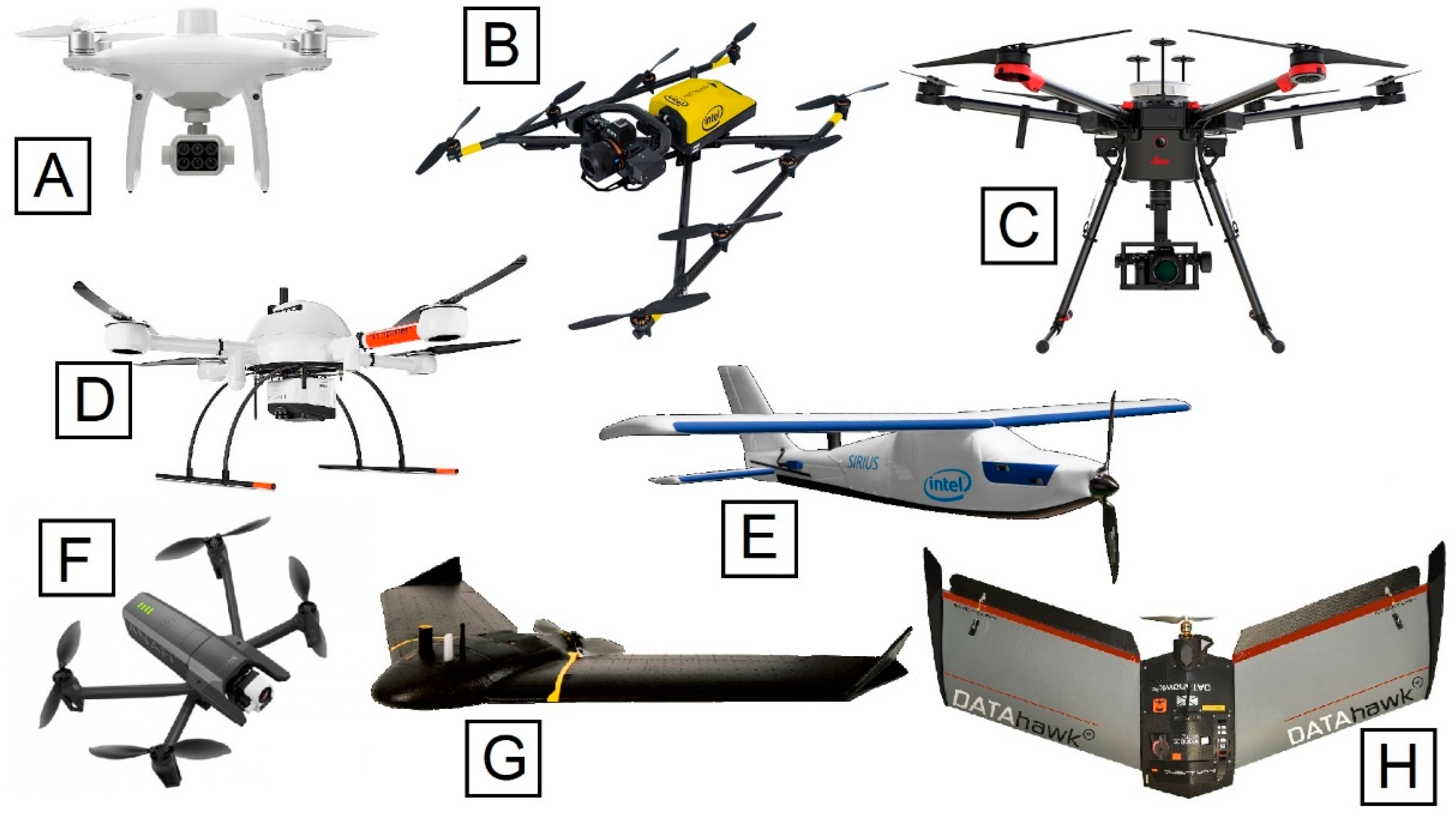
117]. Benefiting from the above, archaeological science has taken one step forward into embracing these new technologies, through various applications—as discussed earlier. Archaeological low-altitude sensing has substantially evolved from the use of platforms purposed for recreational and photographic uses. It has not only engulfed the advancements of those sensors and integrated systems specifically oriented towards archaeological applications but has also benefited from the progress in other fields, for example, precision agriculture and monitoring of structures, who profit from similar UAS-borne sensing. Recent archaeological studies expand the scientific horizons beyond the visual interpretation of the data products and discuss how previously invisible and undocumented features are revealed, while simultaneously paying attention to the spatial and radiometric accuracy and precision of presented results. It goes without saying that high-resolution and high-accuracy products, and information retrieval from multiple wavelengths, are accompanied by considerable costs. Although a trend is evident regarding researchers who invest in high-end fully autonomous integrated UAS, more application-oriented projects seem to prefer custom solutions. Therefore, in this section, we provide information on both integrated ready-to-fly UAS and specialized options for payload integration. Table 1 provides some examples of integrated solutions, which are purposed or can be repurposed for archaeological remote sensing surveys (also examples in Figure 10). The reported integrated systems are ready-to-fly UAS with pre-equipped navigation system, autopilot, sensors, gimbals, and all necessary electrical on-board equipment.

5.1. Platforms

UAS operated for archaeological remote sensing mainly fall into the Micro (<2 kg weight, up to 200 m altitude, <5 km radius, <1 h endurance), Mini (2–20 kg weight, up to 3000 m altitude, <25 km radius, 1–2 h endurance), and seldom Small (20–150 kg weight, up to 5000 m altitude, <50 km radius, 1–5 h endurance) categories (after Qi et al. [118]). While the quality of acquired datasets depends largely on on-board sensors (described in Section 5.4, Section 5.5, Section 5.6 and Section 5.7), platform typology and configuration play an essential role in the success of the remote-sensing mission, simultaneously constraining the payload that may be deployed and the flight planning. Fixed-wing UAS have a clear advantage in archaeological surveys because their longer flight autonomy allows the coverage of much more extensive historical sites and landscapes than the average multi-rotor (Table 2). Fixed-wing aircrafts’ increased stability allows greater control over flight parameters and the quality of collected data. However, the competition with rotary-wing aircraft is always present because multi-rotors have greater maneuverability and allow heavier payloads and more customizability, therefore having more options for sensor integration.
Multi-rotor UAS are additionally more compact (speaking for the same platform body size-to-payload weight ratio), and subsequently more easily transportable. Despite their short flying duration, which limits the archaeological area that can be covered within a single flight, they have some distinct attributes that may be necessary in certain contexts, as the ability to hover and capture data while remaining over one place, the ease of capturing oblique imagery, and vertical take-off and landing that allows for more flexible deployment in areas that would be inaccessible with fixed-wing aircraft. Some conventional multi-rotor frames used in customized UAS for archaeological applications are MikroKopter’s MK8-2500 (8 rotors, folded dimensions 64 cm × 60 cm, max. payload 2.5 kg) and MK8-3500 (8 rotors, max. payload 3.5 kg), and VulcanUAV’s Black Widow (4 rotors, max payload 4.6 kg) and Raven (8 rotors-X8 configuration, max. payload 10 kg).

5.2. Orientation Systems

The miniaturization of computer boards, Global Navigation Satellite Systems (GNSS) receivers and antennas, inertial measurement units (IMUs) and, in general, electronics has allowed the integration of hybrid measurement units (HMU) for UAS whose measurements can be processed, in a hybrid navigation system (HNS) or in post-processing, in a hybrid orientation system (HOS). The results depend on the quality of the GNSS receiver and the GNSS antenna, and the accuracy of the attitude part of the orientation is highly dependent on the IMU quality and flight dynamics. To deliver orientation parameters, and data products at cm-level with increased reliability, primarily two modifications of kinematic GNSS measurements are being adopted for UAS applications. RTK—which considers that there is real time communication of the UAS with a ground reference station (using radio link)—delivers corrections to GNSS measurements during the flight. Post-processed kinematic (PPK), on the other hand, depends on corrections from a reference station that are applied post-flight [120,121]. As RTK-enabled receivers have already been available on several commercial platforms, and PPK is becoming more common for UAS-based archaeological surveys, it is useful to review the current capabilities of HMU and HNS solutions for unmanned aircraft operations. Therefore, the state-of-the-art integrated solutions are presented in Table 3, taking into consideration that the values given are simply indicative as they include general specifications and optimal testing conditions.

5.3. Light Detection and Ranging (LiDAR) Sensors

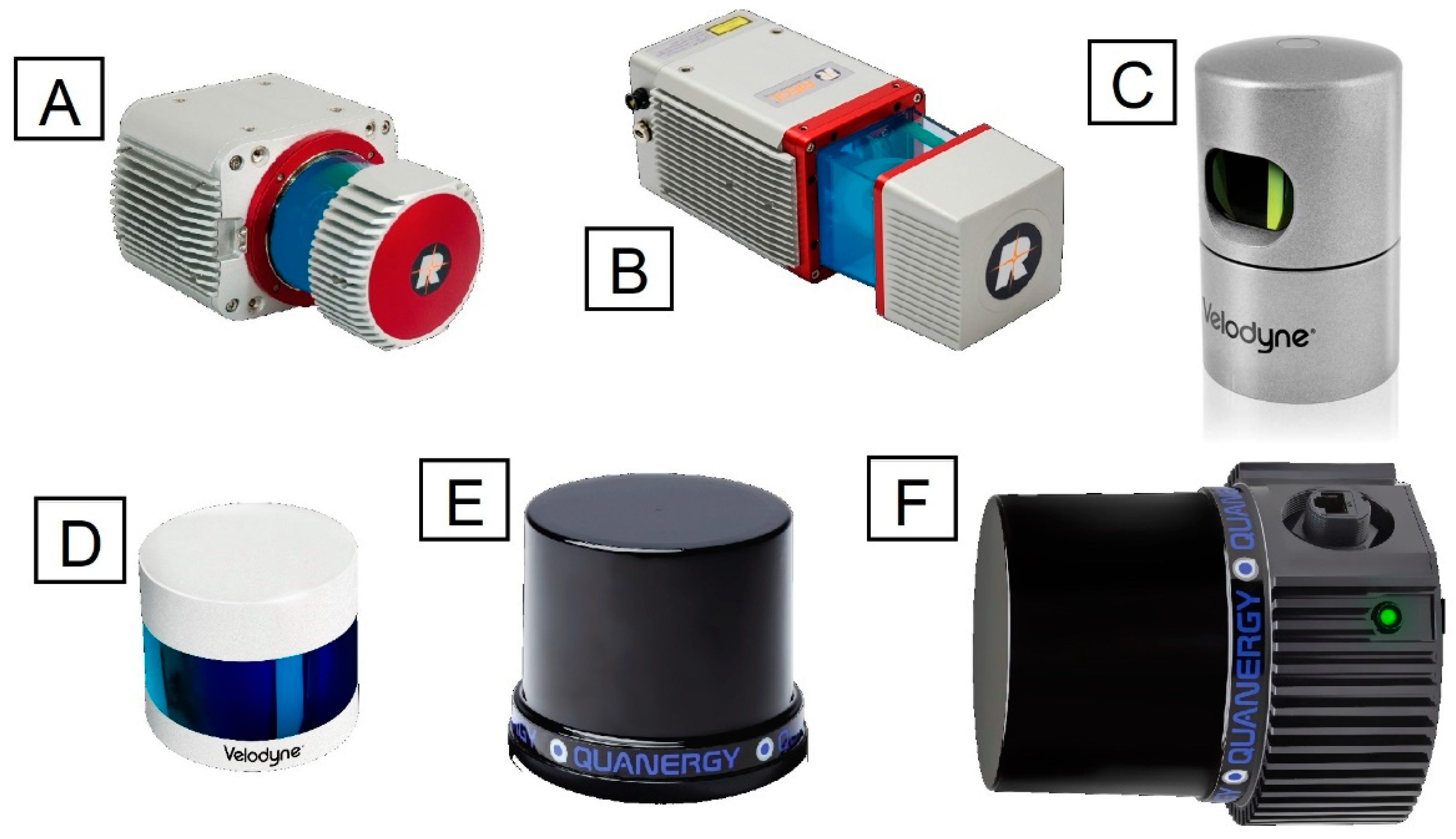
The reduction in LiDAR sensor size and price are making them more common for UAS-based archaeological surveys. The market of 3D laser scanners for unmanned platforms has grown rapidly, and the technological developments are increasing the quality of data acquired by these sensors. This creates the prospect of replacing airborne LiDAR since essential characteristics of LiDAR data are largely unaffected by the carrying platform, which implies that existing well-developed processing techniques can be used on these data. Limitations caused by the tradeoff between performance and size or cost of LiDAR, can be partially overcome by the proximity of the sensor and the surveyed area in comparison to airborne scanning. Presently Quanergy, Riegl, and Velodyne dominate the market of LiDAR sensors manufactured to be mounted on UAS (examples in Figure 11), as the overwhelming majority of integrated payload for scanning, include their products. Table 4 presents the available lightweight LiDAR sensors. A detailed account of integrated LiDAR payloads can be found in Appendix A.

5.4. Near-Infrared and Multi-Spectral Cameras

The exploitation of NIR imagery can contribute significantly to UAS-based archaeology [122], and therefore various sensor solutions have been explored to incorporate the NIR spectrum in prospection-related applications. As the meta-analysis revealed, the Canon S110 digital cameras, modified for red-edge and near-infrared imaging, have been frequently used over the past decade, serving as a default multi-spectral solution for the senseFly fixed-wing aircrafts until 2014. These cameras are currently being replaced by various high-resolution models, as the modification of compact and digital single-lens reflex (DSLR) cameras, for beyond-visible acquisition, becomes more prevalent. At the same time, various lower-resolution lightweight camera options for UAS-based MS imaging are available, having the advantage of more than three narrower bands. 
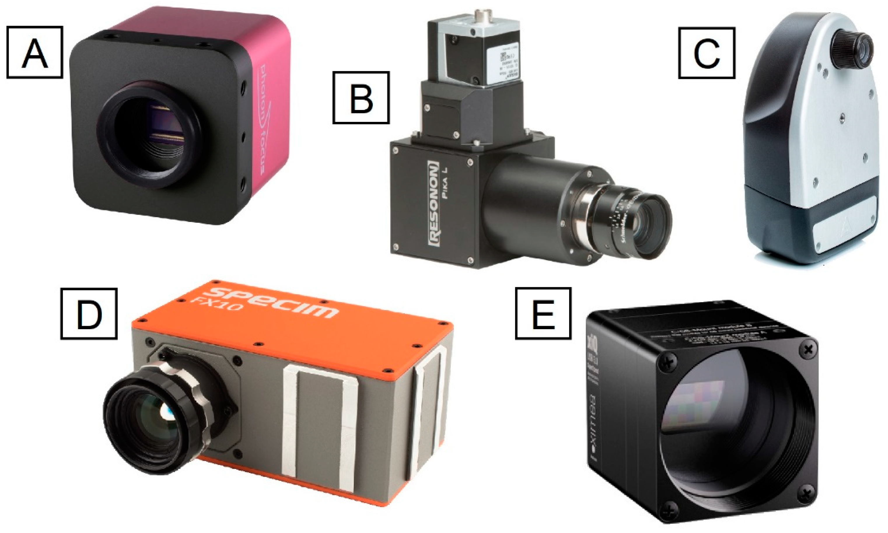
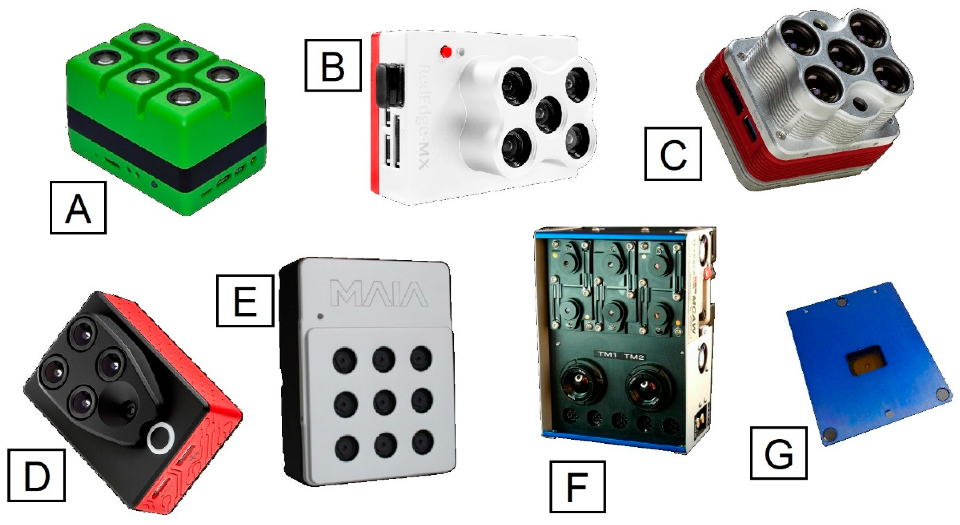
Table 5 summarizes the characteristics of some typical and/or representative camera options (in Figure 12).

5.5. Hyperspectral Cameras

To cover the need for the detection of information from multiple very narrow bands of the electromagnetic spectrum [123], and towards the more accurate calculation of vegetation and soil indices, HS imaging sensors have consistently been miniaturized, and can currently be mounted on UAS platforms. Some of them are listed in Table 6 (also examples in Figure 13). It is the authors’ opinion that these sensors will continue to play a significant role in UAS-based archaeological prospection, and geoarchaeology.

5.6. Thermal Cameras

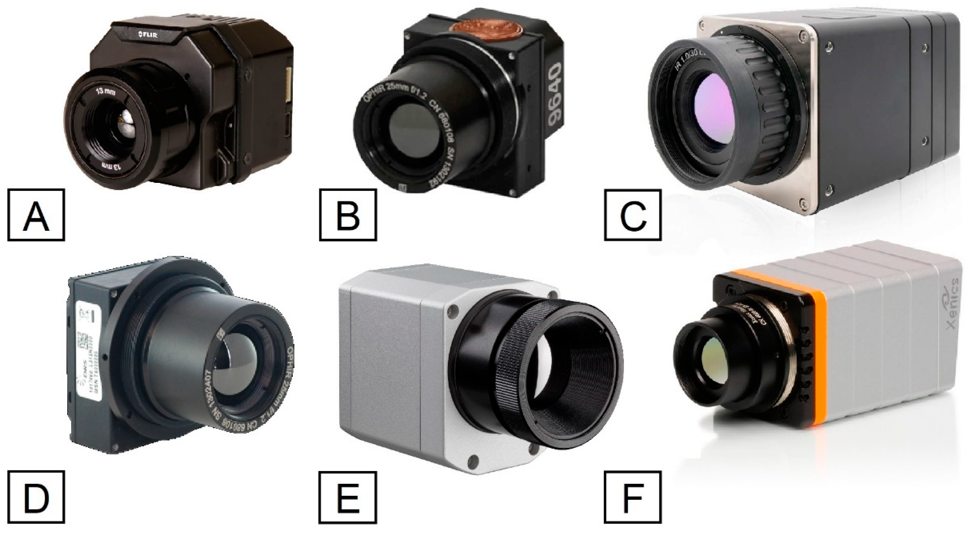
There have been essential advancements in thermal camera miniaturization in recent years. Lightweight, small-size LWIR imagers, such as those developed by FLIR, were first introduced in a military context for remote reconnaissance and are becoming more common in UAS-based remote-sensing applications such as archaeological prospection. Table 7 compiles some existing products in the family of thermal sensors, suitable for light UAS (also examples in Figure 14).

5.7. Ground-Penetrating Radars

A ground-penetrating radar (GPR) is an active non-destructive geophysical sensing technique that utilizes electromagnetic radiation in the microwave band and has always been entangled with archaeological prospection for the subsurface mapping of artifacts, features, and patterning [124,125]. Although there are currently no integrated payload solutions for UAS-borne microwave-based detection, a few recent studies report experiments towards the manufacture of customized systems for GPR non-destructive applications [126,127,128].

6. Conclusions

The last decade was marked by a radical miniaturization and integration of UAS-mounted sensors, which gradually fostered the adoption of low-altitude sensing techniques for archaeological applications, including but not limited to prospection. Notwithstanding the considerable number of works reviewed here, UAS-based archaeological remote-sensing applications and, especially, those dealing with the beyond-visible spectra to identify multi-spectral contrast variations, are still scarce. This is most likely because the relevant technology has only recently reached a certain level of maturity and high-resolution solutions remain considerably expensive. The recently observed trends, regarding increasingly more metrically and radiometrically accurate data-acquisition and data production in archaeological surveys, and the adoption of well-established processing and analytical techniques from satellite and airborne sensing, suggest a promising perspective. However, the aspects of spatial precision and accuracy still remain undocumented in numerous archaeological surveys which suggests a need for better training regarding metric concepts and for increasing the collaborations between archaeologists and geomatics experts to achieve optimal results in archaeological remote-sensing projects. Metric, radiometric and semantic contents of acquired archaeological data and meta-data should not be neglected as they contain valuable information for archaeological interpretations. It should be further highlighted that automation in the detection of historical residues remains an undeniably complex and challenging task due to the unique morphological, stratigraphical, topographical and archaeological characteristics of each archaeological site [129,130,131]. For this reason the majority of UAS-borne prospection studies still depend on the parallel acquisition of data with ground-based geophysical methods such as electrical resistivity surveys, ground-penetrating radar, electromagnetic conductivity surveys, and magnetic gradiometry surveys, on historical aerial footage, and on satellite datasets, which complete our perspectives over historical terrains. Lastly, the authors would like to point out that, despite the observed allocation of the analyzed studies on a global scale, the gaps on the relevant map do not necessarily reflect the contemporary worldwide distribution of archaeological remote-sensing research. There are various reported examples of innovative archaeological studies in Oceania and Asia [132,133,134,135]—actively using drones—which due to the strictly set selection criteria were excluded from the presented meta-analysis. The typology of the historical remains also plays a large part in this distribution anomaly. However, UAS-based remote sensing is widely applied in these areas, mainly directed towards heritage recording.

Supplementary Materials

The following is available online at https://www.mdpi.com/2504-446X/4/3/46/s1: Figure S1. PRISMA 2009 flow diagram, Table S2. List of meta-analysis publications.

Author Contributions

Conceptualization, E.A.; Data Curation, E.A.; Methodology, E.A.; Validation, E.A.; Formal analysis, E.A.; Investigation, E.A.; Resources, E.A.; Writing–Original draft, E.A.; Visualization, E.A.; Writing–review and editing, E.A. and F.R., Supervision, F.R.; Project administration, F.R.; Funding acquisition F.R. All authors have read and agreed to the published version of the manuscript.

Funding

This project has received funding from the European Union’s Framework Program for Research and Innovation Horizon 2020 (2014–2020) under the Marie-Skłodowska Curie Grant Agreement No. 754511 and from the Compagnia di San Paolo.

Conflicts of Interest

The authors declare no potential conflict of interest.

Abbreviations

3DThree-Dimensional
DDSMDifferential Digital Surface Models
DEMDigital Elevation Model
DSLRDigital Single-Lens Reflex
DSMDigital Surface Model
DTMDigital Terrain Model
GISGeographic Information Systems
GNSSGlobal Navigation Satellite Systems
GPRGround-Penetrating Radar
HMUHybrid Measurement Units
HNSHybrid Navigation System
HOSHybrid Orientation System
HSHyper-spectral
IMUInertial Measurement Units
LiDARLight Detection and Ranging
LRMLocal Relief Modeling
LWIRLong-Wavelength Infrared
MSMulti-spectral
MVSMultiple-View-Stereo
NDVINormalized Difference Vegetation Index
NIRNear-Infrared
PCAPrincipal Component Analysis
PPKPost-Processed Kinematic
RGBRed Green Blue
RPASRemotely Piloted Aircraft Systems
RTKReal-Time Kinematic
SfMStructure-from-Motion
SPSStandard Positioning Service
SVFSky-View Factor
TIRThermal Infrared
UASUnmanned Aerial Vehicle
VISVisible

Appendix A

Table A1. Integrated LiDAR payloads for UAS.
BrandModelMax. Range (m)FOV (deg)Max. ReturnsShots/s (1000) **Accuracy (cm)Weight (kg)LiDAR SensorGNSSIMUStorageCamera
3D TargetScanfly HD2120(V)40, (H)360230051.95Velodyne Puck 32MR Drones 04 00046 i001 Drones 04 00046 i002 Drones 04 00046 i003 Drones 04 00046 i004 *
Scanfly LITE100(V)30, (H)360230051.6Velodyne Puck Lite Drones 04 00046 i005 Drones 04 00046 i006 Drones 04 00046 i007 Drones 04 00046 i008 *
Scanfly ULTRA (V)40, (H)360260050.95Velodyne Ultra Puck Drones 04 00046 i009 Drones 04 00046 i010 Drones 04 00046 i011 Drones 04 00046 i012 *
EmesentHovermap HF1100360230031.8Velodyne VLP-16 Lite Drones 04 00046 i013 Drones 04 00046 i014 Drones 04 00046 i015 Drones 04 00046 i016
Hovermap VF1100360230031.8Velodyne VLP-16 Lite Drones 04 00046 i017 Drones 04 00046 i018 Drones 04 00046 i019 Drones 04 00046 i020
GeoCue GroupTrue View 410 3DIS200(V)20, (H)360343032Quanergy M8-Ultra Drones 04 00046 i021 Drones 04 00046 i022 Drones 04 00046 i023 Drones 04 00046 i024
GeodeticsGeo-MMS LiDAR M8150(V)20, (H)36034303 Quanergy M8-Core Drones 04 00046 i025 Drones 04 00046 i026 Drones 04 00046 i027 Drones 04 00046 i028
Geo-MMS LiDAR VLP-16100360230051.59Velodyne VLP-16 Drones 04 00046 i029 Drones 04 00046 i030 Drones 04 00046 i031 Drones 04 00046 i032
Geo-MMS LiDAR VLP-32E100(V)40, (H)36027006 Velodyne VLP-32E Drones 04 00046 i033 Drones 04 00046 i034 Drones 04 00046 i035 Drones 04 00046 i036
Geo-MMS LiDAR VLP-32C200(V)40, (H)36026003 Velodyne VLP-32C Drones 04 00046 i037 Drones 04 00046 i038 Drones 04 00046 i039 Drones 04 00046 i040
Geo-MMS LiDAR CL-36077536043101 Teledyne Optech CL-360 Drones 04 00046 i041 Drones 04 00046 i042 Drones 04 00046 i043 Drones 04 00046 i044
LiDAR SWISSLS Nano M8200360340021.95Quanergy M8-Core Drones 04 00046 i045 Drones 04 00046 i046 Drones 04 00046 i047 Drones 04 00046 i048
LS Nano Vux330360510052.95RIEGL miniVUX-1UAV Drones 04 00046 i049 Drones 04 00046 i050 Drones 04 00046 i051 Drones 04 00046 i052
Surveyor100360230052.3Velodyne VLP-16 Drones 04 00046 i053 Drones 04 00046 i054 Drones 04 00046 i055 Drones 04 00046 i056
Surveyor Ultra200360260052.7Velodyne VLP-32 Drones 04 00046 i057 Drones 04 00046 i058 Drones 04 00046 i059 Drones 04 00046 i060
LiDARUSARevolution 6010036023004.61.53Velodyne PUCK Drones 04 00046 i061 Drones 04 00046 i062 Drones 04 00046 i063 Drones 04 00046 i064
M200 Series Snoopy150(V)40, (H)360244021.7Quanergy M8-Core Drones 04 00046 i065 Drones 04 00046 i066 Drones 04 00046 i067 Drones 04 00046 i068
Snoopy A-series100(V)40, (H)360270062.51Velodyne VLP-32E Drones 04 00046 i069 Drones 04 00046 i070 Drones 04 00046 i071 Drones 04 00046 i072
Snoopy miniVUX330360510052.9RIEGL miniVUX-1UAV Drones 04 00046 i073 Drones 04 00046 i074 Drones 04 00046 i075 Drones 04 00046 i076
PhoenixSCOUT-16100(V)30, (H)36023005.51.65Velodyne VLP-16 Drones 04 00046 i077 Drones 04 00046 i078 Drones 04 00046 i079 Drones 04 00046 i080 *
SCOUT-32100(V)41.33, (H)360270022.4 Drones 04 00046 i081 Drones 04 00046 i082 Drones 04 00046 i083 Drones 04 00046 i084 *
miniRANGER-LITE25036051001.51.55RIEGL miniVUX-1UAV Drones 04 00046 i085 Drones 04 00046 i086 Drones 04 00046 i087 Drones 04 00046 i088 *
PolyExplorePolyscanner LM16100(V)30, (H)360230032.3Velodyne VLP-16 Drones 04 00046 i089 Drones 04 00046 i090 Drones 04 00046 i091 Drones 04 00046 i092
Polyscanner LM32200(V)40, (H)360260032.3Velodyne VLP-32C Drones 04 00046 i093 Drones 04 00046 i094 Drones 04 00046 i095 Drones 04 00046 i096
Polyscanner LM16C100(V)30, (H)360230032.3Velodyne VLP-16 Drones 04 00046 i097 Drones 04 00046 i098 Drones 04 00046 i099 Drones 04 00046 i100
Polyscanner LM32C200(V)40, (H)360260032.3Velodyne VLP-32C Drones 04 00046 i101 Drones 04 00046 i102 Drones 04 00046 i103 Drones 04 00046 i104
RedTailRTL-400120(V)40, (H)4052001.52.1OEM Drones 04 00046 i105 Drones 04 00046 i106 Drones 04 00046 i107 Drones 04 00046 i108
RoutesceneLidarPod100(V)40, (H)360270061.3Velodyne VLP-32E Drones 04 00046 i109 Drones 04 00046 i110 Drones 04 00046 i111 Drones 04 00046 i112
ScanVizSV-Mini200(V)40, (H)36026002.51.4Velodyne VLP-32C Drones 04 00046 i113 Drones 04 00046 i114 Drones 04 00046 i115 Drones 04 00046 i116
SouthSZT-V100100(V)30, (H)360230031.5Velodyne VLP-16 Drones 04 00046 i117 Drones 04 00046 i118 Drones 04 00046 i119 Drones 04 00046 i120
SZT-V200200(V)40, (H)360260031.6Velodyne VLP-32 Drones 04 00046 i121 Drones 04 00046 i122 Drones 04 00046 i123 Drones 04 00046 i124
SZT-R25025036051001.52.1RIEGL miniVUX-1UAV Drones 04 00046 i125 Drones 04 00046 i126 Drones 04 00046 i127 Drones 04 00046 i128
YellowScanSurveyor100360230051.6Velodyne VLP-16 Drones 04 00046 i129 Drones 04 00046 i130 Drones 04 00046 i131 Drones 04 00046 i132 *
Surveyor Ultra200360260051.7Velodyne VLP-32 Drones 04 00046 i133 Drones 04 00046 i134 Drones 04 00046 i135 Drones 04 00046 i136 *
Vx-15330360510052.6RIEGL miniVUX-1UAV Drones 04 00046 i137 Drones 04 00046 i138 Drones 04 00046 i139 Drones 04 00046 i140 *
Vx-15+330360520052.6RIEGL miniVUX-2UAV Drones 04 00046 i141 Drones 04 00046 i142 Drones 04 00046 i143 Drones 04 00046 i144 *
Note: (V) vertical; (H) horizontal; * optional; ** at maximum laser pulse repetition rate (PRR) and full power—single return.

References

  1. Gojda, M. The Contribution of Aerial Archaeology to European Landscape Studies: Past Achievements, Recent Developments and Future Perspectives. J. Eur. Archaeol. 1997, 5, 91–104. [Google Scholar] [CrossRef]
  2. Bewley, R.H. Aerial survey for archaeology. Photogramm. Rec. 2003, 18, 273–292. [Google Scholar] [CrossRef] [Green Version]
  3. Ceraudo, G. Aerial Photography in Archaeology. In Good Practice in Archaeological Diagnostics; Corsi, C., Slapšak, B., Vermeulen, F., Eds.; Natural Science in Archaeology; Springer International Publishing: Cham, Switzerland, 2013; pp. 11–30. ISBN 978-3-319-01783-9. [Google Scholar]
  4. Ciminale, M.; Becker, H.; Gallo, D. Integrated technologies for archaeological investigation; the Celone Valley project. Archaeol. Prospect. 2007, 14, 167–181. [Google Scholar] [CrossRef]
  5. Campana, S.; Dabas, M.; Marasco, L.; Piro, S.; Zamuner, D. Integration of remote sensing, geophysical surveys and archaeological excavation for the study of a medieval mound (Tuscany, Italy). Archaeol. Prospect. 2009, 16, 167–176. [Google Scholar] [CrossRef]
  6. Sarris, A.; Papadopoulos, N.; Agapiou, A.; Salvi, M.C.; Hadjimitsis, D.G.; Parkinson, W.A.; Yerkes, R.W.; Gyucha, A.; Duffy, P.R. Integration of geophysical surveys, ground hyperspectral measurements, aerial and satellite imagery for archaeological prospection of prehistoric sites: The case study of Vésztő-Mágor Tell, Hungary. J. Archaeol. Sci. 2013, 40, 1454–1470. [Google Scholar] [CrossRef]
  7. Caspari, G.; Sadykov, T.; Blochin, J.; Buess, M.; Nieberle, M.; Balz, T. Integrating Remote Sensing and Geophysics for Exploring Early Nomadic Funerary Architecture in the “Siberian Valley of the Kings”. Sensors 2019, 19, 3074. [Google Scholar] [CrossRef] [Green Version]
  8. Rączkowski, W. Aerial Archaeology. In Encyclopedia of Global Archaeology; Smith, C., Ed.; Springer: New York, NY, USA, 2014; pp. 33–38. ISBN 978-1-4419-0426-3. [Google Scholar]
  9. Rączkowski, W. Aerial Archaeology. In Field Archaeology from around the World; Carver, M., Gaydarska, B., Montón-Subías, S., Eds.; SpringerBriefs in Archaeology; Springer International Publishing: Cham, Switzerland, 2015; pp. 19–25. ISBN 978-3-319-09818-0. [Google Scholar]
  10. Agapiou, A.; Hadjimitsis, D.G.; Sarris, A.; Georgopoulos, A.; Alexakis, D.D. Optimum temporal and spectral window for monitoring crop marks over archaeological remains in the Mediterranean region. J. Archaeol. Sci. 2013, 40, 1479–1492. [Google Scholar] [CrossRef]
  11. Neubauer, W. Images of the invisible-prospection methods for the documentation of threatened archaeological sites. Naturwissenschaften 2001, 88, 13–24. [Google Scholar] [CrossRef]
  12. Beck, A.R. Archaeological Site Detection: The Importance of Contrast; Curran Associates, Inc.: Newcastle Upon Tyne, UK, 2008; pp. 307–312. [Google Scholar]
  13. Perisset, M.C.; Tabbagh, A. Interpretation of thermal contrast on bare soils. Archaeometry 1981, 23, 169–187. [Google Scholar] [CrossRef]
  14. Devereux, B.J.; Amable, G.S.; Crow, P. Visualisation of LiDAR terrain models for archaeological feature detection. Antiquity 2008, 82, 470–479. [Google Scholar] [CrossRef]
  15. Challis, K.; Kokalj, Z.; Kincey, M.; Moscrop, D.; Howard, A.J. Airborne lidar and historic environment records. Antiquity 2008, 82, 1055–1064. [Google Scholar] [CrossRef]
  16. Devereux, B.J.; Amable, G.S.; Crow, P.; Cliff, A.D. The potential of airborne lidar for detection of archaeological features under woodland canopies. Antiquity 2005, 79, 648–660. [Google Scholar] [CrossRef]
  17. Chase, A.S.Z.; Chase, D.Z.; Chase, A.F. LiDAR for Archaeological Research and the Study of Historical Landscapes. In Sensing the Past; Masini, N., Soldovieri, F., Eds.; Geotechnologies and the Environment; Springer International Publishing: Cham, Switzerland, 2017; Volume 16, pp. 89–100. ISBN 978-3-319-50516-9. [Google Scholar]
  18. Bennett, R.; Welham, K.; Hill, R.A.; Ford, A. A Comparison of Visualization Techniques for Models Created from Airborne Laser Scanned Data: A Comparison of Visualization Techniques for ALS Data. Archaeol. Prospect. 2012, 19, 41–48. [Google Scholar] [CrossRef]
  19. Štular, B.; Kokalj, Ž.; Oštir, K.; Nuninger, L. Visualization of lidar-derived relief models for detection of archaeological features. J. Archaeol. Sci. 2012, 39, 3354–3360. [Google Scholar] [CrossRef]
  20. Parcak, S.H. Satellite Remote Sensing for Archaeology; Routledge: London, UK; New York, NY, USA, 2009; pp. 52–103. ISBN 978-0-415-44877-2. [Google Scholar]
  21. Leisz, S.J. An Overview of the Application of Remote Sensing to Archaeology during the Twentieth Century. In Mapping Archaeological Landscapes from Space; SpringerBriefs in Archaeology; Springer: New York, NY, USA, 2013; Volume 5, pp. 11–19. ISBN 978-1-4614-6073-2. [Google Scholar]
  22. Comer, D.C. Aerial and Satellite Remote Sensing in Archaeology. In Encyclopedia of Global Archaeology; Smith, C., Ed.; Springer: New York, NY, USA, 2014; pp. 29–32. ISBN 978-1-4419-0426-3. [Google Scholar]
  23. Kalayci, T.; Lasaponara, R.; Wainwright, J.; Masini, N. Multispectral Contrast of Archaeological Features: A Quantitative Evaluation. Remote Sens. 2019, 11, 913. [Google Scholar] [CrossRef] [Green Version]
  24. Lambers, K. Airborne and Spaceborne Remote Sensing and Digital Image Analysis in Archaeology. In Digital Geoarchaeology; Siart, C., Forbriger, M., Bubenzer, O., Eds.; Natural Science in Archaeology; Springer International Publishing: Cham, Switzerland, 2018; pp. 109–122. ISBN 978-3-319-25314-5. [Google Scholar]
  25. Winterbottom, S.J.; Dawson, T. Airborne multi-spectral prospection for buried archaeology in mobile sand dominated systems. Archaeol. Prospect. 2005, 12, 205–219. [Google Scholar] [CrossRef]
  26. Rowlands, A.; Sarris, A. Detection of exposed and subsurface archaeological remains using multi-sensor remote sensing. J. Archaeol. Sci. 2007, 34, 795–803. [Google Scholar] [CrossRef]
  27. Aqdus, S.A.; Hanson, W.S.; Drummond, J. Finding Archaeological Cropmarks: A Hyperspectral Approach. In Remote Sensing for Environmental Monitoring, GIS Applications, and Geology VII (Vol. 6749); Ehlers, M., Michel, U., Eds.; SPIE: Florence, Italy, 2007. [Google Scholar]
  28. Scollar, I. Archaeological Prospecting and Remote Sensing. In Topics in Remote Sensing; Cambridge University Press: Cambridge, UK, 1990; pp. 591–633. ISBN 978-0-521-32050-4. [Google Scholar]
  29. Cool, A.C. Thermography. In The Encyclopedia of Archaeological Sciences; Varela, S.L., Ed.; John Wiley & Sons, Inc.: Hoboken, NJ, USA, 2018; pp. 1–5. ISBN 978-0-470-67461-1. [Google Scholar]
  30. Palombo, A.; Pascucci, S.; Pergola, N.; Pignatti, S.; Santini, F.; Soldovieri, F. Multispectral Thermal Airborne TASI-600 Data to Study the Pompeii (IT) Archaeological Area; Copernicus Publications: Vienna, Austria, 2016; pp. 17–22. [Google Scholar]
  31. Pignatti, S.; Palombo, A.; Pascucci, S.; Santini, F.; Laneve, G. Survey of the Pompeii (IT) Archaeological Regions with the Multi-Spectral Thermal Airborne TASI Data; Copernicus Publications: Vienna, Austria, 2017; pp. 23–28. [Google Scholar]
  32. Savage, S.H.; Levy, T.E.; Jones, I.W. Prospects and problems in the use of hyperspectral imagery for archaeological remote sensing: A case study from the Faynan copper mining district, Jordan. J. Archaeol. Sci. 2012, 39, 407–420. [Google Scholar] [CrossRef]
  33. Opitz, R.; Herrmann, J. Recent Trends and Long-standing Problems in Archaeological Remote Sensing. J. Comput. Appl. Archaeol. 2018, 1, 19–41. [Google Scholar] [CrossRef] [Green Version]
  34. Schlitz, M. A review of low-level aerial archaeology and its application in Australia. Aust. Archaeol. 2004, 59, 51–58. [Google Scholar] [CrossRef]
  35. Verhoeven, G.J.J. Providing an archaeological bird’s-eye view—An overall picture of ground-based means to execute low-altitude aerial photography (LAAP) in Archaeology. Archaeol. Prospect. 2009, 16, 233–249. [Google Scholar] [CrossRef]
  36. Martínez-del-Pozo, J.-Á.; Cerrillo-Cuenca, E.; Salas-Tovar, E. Low Altitude Aerial Photography Applications for Digital Surface Models Creation in Archaeology: Low Altitude Aerial Photography Applications. Trans. GIS 2013, 17, 227–246. [Google Scholar] [CrossRef]
  37. Vilbig, J.M.; Sagan, V.; Bodine, C. Archaeological surveying with airborne LiDAR and UAV photogrammetry: A comparative analysis at Cahokia Mounds. J. Archaeol. Sci. Rep. 2020, 33, 102509. [Google Scholar] [CrossRef]
  38. Barba, S.; Barbarella, M.; Di Benedetto, A.; Fiani, M.; Limongiello, M. Quality assessment of UAV photogrammetric archaeological. Int. Arch. Photogramm. Remote Sens. Spat. Inf. Sci. 2019, XLII-2/W9, 93–100. [Google Scholar] [CrossRef] [Green Version]
  39. Hill, A.C. Economical drone mapping for archaeology: Comparisons of efficiency and accuracy. J. Archaeol. Sci. Rep. 2019, 24, 80–91. [Google Scholar] [CrossRef]
  40. Pajares, G. Overview and Current Status of Remote Sensing Applications Based on Unmanned Aerial Vehicles (UAVs). Photogramm. Eng. Remote Sens. 2015, 81, 281–330. [Google Scholar] [CrossRef] [Green Version]
  41. Campana, S. Drones in Archaeology. State-of-the-art and Future Perspectives: Drones in Archaeology. Archaeol. Prospect. 2017, 24, 275–296. [Google Scholar] [CrossRef]
  42. Searcy, M.T. Drones. In The Encyclopedia of Archaeological Sciences; Varela, S.L., Ed.; John Wiley & Sons, Inc.: Hoboken, NJ, USA, 2018; pp. 1–3. ISBN 978-0-470-67461-1. [Google Scholar]
  43. Themistocleous, K. Themistocleous, K. The Use of UAVs for Cultural Heritage and Archaeology. In Remote Sensing for Archaeology and Cultural Landscapes; Hadjimitsis, D.G., Themistocleous, K., Cuca, B., Agapiou, A., Lysandrou, V., Lasaponara, R., Masini, N., Schreier, G., Eds.; Springer Remote Sensing/Photogrammetry; Springer International Publishing: Cham, Switzerland, 2020; pp. 241–269. ISBN 978-3-030-10978-3. [Google Scholar]
  44. Gojda, M. Current Development in Archaeological Remote Sensing: A Central European Experience and Evaluation. Interdiscip. Archaeol.-Nat. Sci. Archaeol. 2019, X, 155–164. [Google Scholar] [CrossRef]
  45. Luo, L.; Wang, X.; Guo, H.; Lasaponara, R.; Zong, X.; Masini, N.; Wang, G.; Shi, P.; Khatteli, H.; Chen, F.; et al. Airborne and spaceborne remote sensing for archaeological and cultural heritage applications: A review of the century (1907–2017). Remote Sens. Environ. 2019, 232, 111280. [Google Scholar] [CrossRef]
  46. Waagen, J. New technology and archaeological practice. Improving the primary archaeological recording process in excavation by means of UAS photogrammetry. J. Archaeol. Sci. 2019, 101, 11–20. [Google Scholar] [CrossRef]
  47. López, J.; Mulero-Pázmány, M. Drones for Conservation in Protected Areas: Present and Future. Drones 2019, 3, 10. [Google Scholar] [CrossRef] [Green Version]
  48. Singh, K.K.; Frazier, A.E. A meta-analysis and review of unmanned aircraft system (UAS) imagery for terrestrial applications. Int. J. Remote Sens. 2018, 39, 5078–5098. [Google Scholar] [CrossRef]
  49. Adamopoulos, E.; Rinaudo, F. Enhancing Image-Based Multiscale Heritage Recording with Near-Infrared Data. ISPRS Int. J. Geo-Inf. 2020, 9, 269. [Google Scholar] [CrossRef] [Green Version]
  50. Agudo, P.; Pajas, J.; Pérez-Cabello, F.; Redón, J.; Lebrón, B. The Potential of Drones and Sensors to Enhance Detection of Archaeological Cropmarks: A Comparative Study between Multi-Spectral and Thermal Imagery. Drones 2018, 2, 29. [Google Scholar] [CrossRef] [Green Version]
  51. Barazzetti, L.; Brumana, R.; Oreni, D.; Cuca, B.; Previtali, M.; Roncoroni, F. Finding Buried Remains Using Thermal Images. Int. J. Herit. Digit. Era 2015, 4, 295–306. [Google Scholar] [CrossRef] [Green Version]
  52. Brooke, C.; Clutterbuck, B. Mapping Heterogeneous Buried Archaeological Features Using Multisensor Data from Unmanned Aerial Vehicles. Remote Sens. 2019, 12, 41. [Google Scholar] [CrossRef] [Green Version]
  53. Brumana, R.; Oreni, D.; Van Hecke, L.; Barazzetti, L.; Previtali, M.; Roncoroni, F.; Valente, R. Combined geometric and thermal analysis from UAV platforms for archaeological heritage documenation. ISPRS Ann. Photogramm. Remote Sens. Spat. Inf. Sci. 2013, II-5/W1, 49–54. [Google Scholar] [CrossRef] [Green Version]
  54. Calleja, J.F.; Pagés, O.R.; Díaz-Álvarez, N.; Peón, J.; Gutiérrez, N.; Martín-Hernández, E.; Relea, A.C.; Melendi, D.R.; Álvarez, P.F. Detection of buried archaeological remains with the combined use of satellite multispectral data and UAV data. Int. J. Appl. Earth Obs. Geoinf. 2018, 73, 555–573. [Google Scholar] [CrossRef]
  55. Casana, J.; Kantner, J.; Wiewel, A.; Cothren, J. Archaeological aerial thermography: A case study at the Chaco-era Blue J community, New Mexico. J. Archaeol. Sci. 2014, 45, 207–219. [Google Scholar] [CrossRef]
  56. Casana, J.; Wiewel, A.; Cool, A.; Hill, A.C.; Fisher, K.D.; Laugier, E.J. Archaeological Aerial Thermography in Theory and Practice. Adv. Archaeol. Pr. 2017, 5, 310–327. [Google Scholar] [CrossRef] [Green Version]
  57. Casella, V.; Franzini, M.; Gorrini, M.E. Crop marks detection through optical and multi-spectral imagery acquired by UAV. In Proceedings of the 2018 Metrology for Archaeology and Cultural Heritage (MetroArchaeo), Cassino, Italy, 22–24 October 2018; pp. 173–177. [Google Scholar]
  58. Chelmus, A.; Radvan, R.; Angheluta, L. Aerial Investigations Corroboration for Archaeology and Monuments. In Proceedings of the 2018 11th International Conference on Developments in eSystems Engineering (DeSE), Cambridge, UK, 2–5 September 2018; pp. 113–116. [Google Scholar]
  59. Colombatti, G.; Aboudan, A.; Bettanini, C.; Magnini, L.; Bettineschi, C.; Deotto, G.; Toninello, L.; Debei, S.; Guio, A.D.; Zanovello, P.; et al. Horus—A drone project for visual and IR imaging. In Proceedings of the 2017 IEEE International Workshop on Metrology for AeroSpace (MetroAeroSpace), Padua, Italy, 21–23 June 2017; pp. 589–592. [Google Scholar]
  60. Cowley, D.; Moriarty, C.; Geddes, G.; Brown, G.; Wade, T.; Nichol, C. UAVs in Context: Archaeological Airborne Recording in a National Body of Survey and Record. Drones 2017, 2, 2. [Google Scholar] [CrossRef] [Green Version]
  61. De Reu, J.; Trachet, J.; Laloo, P.; De Clercq, W. From Low Cost UAV Survey to High Resolution Topographic Data: Developing our Understanding of a Medieval Outport of Bruges: From Low Cost UAV Survey to High Resolution Topographic Data. Archaeol. Prospect. 2016, 23, 335–346. [Google Scholar] [CrossRef]
  62. Evers, R.; Masters, P. The application of low-altitude near-infrared aerial photography for detecting clandestine burials using a UAV and low-cost unmodified digital camera. Forensic Sci. Int. 2018, 289, 408–418. [Google Scholar] [CrossRef] [PubMed] [Green Version]
  63. Faltýnová, M.; Pavelka, K.; Nový, P.; Šedina, J. Complex Archaeological Prospection Using Combination of Non-destructive Techniques. Int. Arch. Photogramm. Remote Sens. Spat. Inf. Sci. 2015, XL-5/W7, 141–146. [Google Scholar] [CrossRef] [Green Version]
  64. Fenger-Nielsen, R.; Hollesen, J.; Matthiesen, H.; Andersen, E.A.S.; Westergaard-Nielsen, A.; Harmsen, H.; Michelsen, A.; Elberling, B. Footprints from the past: The influence of past human activities on vegetation and soil across five archaeological sites in Greenland. Sci. Total Environ. 2019, 654, 895–905. [Google Scholar] [CrossRef]
  65. Fernández-Lozano, J.; Gutiérrez-Alonso, G. Improving archaeological prospection using localized UAVs assisted photogrammetry: An example from the Roman Gold District of the Eria River Valley (NW Spain). J. Archaeol. Sci. Rep. 2016, 5, 509–520. [Google Scholar] [CrossRef]
  66. González, J.F.; Hernández, F.V. NDVI Identification and Survey of a Roman Road in the Northern Spanish Province of Álava. Remote Sens. 2019, 11, 725. [Google Scholar] [CrossRef] [Green Version]
  67. Garzia, F.; Lombardi, M.; Papi, L. Analysis and data acquisition methodology based on flying drones for the implementation of the internet of everything to smart archaeological areas. Int. J. Herit. Arch. Stud. Repairs Maintence 2017, 2, 383–394. [Google Scholar] [CrossRef]
  68. Gehrke, R.; Greiwe, A. RGBI images with UAV and off-the-shelf compact cameras: An investigation of linear sensor characteristics. EARSel eProc. 2014, 13, 53–58. [Google Scholar]
  69. Gini, R.; Passoni, D.; Pinto, L.; Sona, G.; Pulejo, S.; Baracani, M. UAV-Based Images for a Documentation and Active Fruition of the Natural and Cultural Heritage. Boll. AIC 2012, 144, 167–181. [Google Scholar]
  70. González, J.J.F.; González, J.I.F. Prospección arqueológica en NDVI con drones. El uso de geoEuskadi como herramienta de ponderación de un nuevo método. Rev. Mapp. 2018, 29, 24–29. [Google Scholar]
  71. Hill, A.C.; Laugier, E.J.; Casana, J. Archaeological Remote Sensing Using Multi-Temporal, Drone-Acquired Thermal and Near Infrared (NIR) Imagery: A Case Study at the Enfield Shaker Village, New Hampshire. Remote Sens. 2020, 12, 690. [Google Scholar] [CrossRef] [Green Version]
  72. Hill, A.C.; Rowan, Y.; Kersel, M.M. Mapping with Aerial Photographs: Recording the Past, the Present, and the Invisible at Marj Rabba, Israel. Near East. Archaeol. 2014, 77, 182–186. [Google Scholar] [CrossRef]
  73. Khan, S.; Aragão, L.; Iriarte, J. A UAV–lidar system to map Amazonian rainforest and its ancient landscape transformations. Int. J. Remote Sens. 2017, 38, 2313–2330. [Google Scholar] [CrossRef]
  74. Korczyńska, M.; Cappenberg, K.; Nowak, M.; Szwarczewski, P.; Hoyo, M.M. Multi-methodological approaches to investigate large archaeological sites: The case study of the Eneolithic settlement in Mozgawa, western Lesser Poland. J. Archaeol. Sci. Rep. 2019, 27, 101941. [Google Scholar] [CrossRef]
  75. Koucká, L.; Kopačková, V.; Fárová, K.; Gojda, M. UAV Mapping of an Archaeological Site Using RGB and NIR High-Resolution Data. Proceedings 2018, 2, 351. [Google Scholar] [CrossRef] [Green Version]
  76. Lehmann, J.R.K.; Smithson, K.Z.; Prinz, T. Making the invisible visible: Using UAS-based high-resolution color-infrared imagery to identify buried medieval monastery walls. J. Unmanned Veh. Syst. 2015, 3, 58–67. [Google Scholar] [CrossRef]
  77. Levin, S.; Yuan, M.; Adler, M. Thermographic Quantification for Archaeological Prospection at Picuris Pueblo, New Mexico. In Proceedings of the 2018 3rd Digital Heritage International Congress (DigitalHERITAGE) held jointly with 2018 24th International Conference on Virtual Systems & Multimedia (VSMM 2018), San Francisco, CA, USA, 26–30 October 2018; pp. 1–8. [Google Scholar]
  78. Liu, C.; Cao, Y.; Yang, C.; Zhou, Y.; Ai, M. Pattern identification and analysis for the traditional village using low altitude UAV-borne remote sensing: Multifeatured geospatial data to support rural landscape investigation, documentation and management. J. Cult. Herit. 2020, 44, 185–195. [Google Scholar] [CrossRef]
  79. Magnini, L.; Bettineschi, C.; De Guio, A.; Burigana, L.; Colombatti, G.; Bettanini, C.; Aboudan, A. Multisensor-multiscale approach in studying the proto-historic settlement of Bostel in northern Italy. Archeol. Calc. 2019, 30, 347–365. [Google Scholar] [CrossRef]
  80. Malinverni, E.S.; Barbaro, C.C.; Pierdicca, R.; Bozzi, C.A.; Tassetti, A.N. UAV Surveying for a complete mapping and documentation of archaeological findings. The early neolithic site of Portonovo. Int. Arch. Photogramm. Remote Sens. Spat. Inf. Sci. 2016, XLI-B1, 1149–1155. [Google Scholar] [CrossRef]
  81. Masini, N.; Marzo, C.; Manzari, P.; Belmonte, A.; Sabia, C.; Lasaponara, R. On the characterization of temporal and spatial patterns of archaeological crop-marks. J. Cult. Herit. 2018, 32, 124–132. [Google Scholar] [CrossRef]
  82. Mather, A.; Fyfe, R.; Clason, C.; Stokes, M.; Mills, S.; Barrows, T. Automated mapping of relict patterned ground: An approach to evaluate morphologically subdued landforms using unmanned-aerial-vehicle and structure-from-motion technologies. Prog. Phys. Geogr. Earth Environ. 2019, 43, 174–192. [Google Scholar] [CrossRef]
  83. Matoušková, E.; Starková, L.; Pavelka, K.; Nováček, K.; Šedina, J.; Faltýnová, M.; Housarová, E. Using remote sensing data for documentation of archaeological sites in northwestern Mesopotamia. Int. Arch. Photogramm. Remote Sens. Spat. Inf. Sci. 2016, XLI-B5, 335–342. [Google Scholar] [CrossRef]
  84. McLeester, M.; Casana, J.; Schurr, M.R.; Hill, A.C.; Wheeler, J.H. Detecting prehistoric landscape features using thermal, multi-spectral, and historical imagery analysis at Midewin National Tallgrass Prairie, Illinois. J. Archaeol. Sci. Rep. 2018, 21, 450–459. [Google Scholar] [CrossRef]
  85. Ramón, A.G.M.; Barba, L.; Ortiz, A.; Blancas, J. Geophysical prospection at the formative site of Altica in the Teotihacan Valley Piedmont. Anc. Mesoam. 2019, 30, 267–278. [Google Scholar] [CrossRef]
  86. Moriarty, C.; Cowley, D.C.; Wade, T.; Nichol, C.J. Deploying multi-spectral remote sensing for multi-temporal analysis of archaeological crop stress at Ravenshall, Fife, Scotland. Archaeol. Prospect. 2019, 26, 33–46. [Google Scholar] [CrossRef] [Green Version]
  87. Murtha, T.M.; Broadbent, E.N.; Golden, C.; Scherer, A.; Schroder, W.; Wilkinson, B.; Zambrano, A.A. Drone-Mounted Lidar Survey of Maya Settlement and Landscape. Lat. Am. Antiq. 2019, 30, 630–636. [Google Scholar] [CrossRef] [Green Version]
  88. O’Driscoll, J. Landscape applications of photogrammetry using unmanned aerial vehicles. J. Archaeol. Sci. Rep. 2018, 22, 32–44. [Google Scholar] [CrossRef]
  89. Parisi, E.I.; Suma, M.; Güleç Korumaz, A.; Rosina, E.; Tucci, G. Aerial platforms (UAV) surveys in the VIS and TIR range. Applications on archaeology and agriculture. Int. Arch. Photogramm. Remote Sens. Spat. Inf. Sci. 2019, XLII-2/W11, 945–952. [Google Scholar] [CrossRef] [Green Version]
  90. Pavelka, K.; Šedina, J.; Matoušková, E. High Resolution Drone Surveying of the Pista Geoglyph in Palpa, Peru. Geosciences 2018, 8, 479. [Google Scholar] [CrossRef] [Green Version]
  91. González, M.E.P.; Revilla, J.I.G. A new environmental and spatial approach to the Tiwanaku World Heritage site (Bolivia) using remote sensing (UAV and satellite images). Geoarchaeology 2020, 35, 416–429. [Google Scholar] [CrossRef]
  92. Pisz, M.; Tomas, A.; Hegyi, A. Non-destructive research in the surroundings of the Roman Fort Tibiscum (today Romania). Archaeol. Prospect. 2020. [Google Scholar] [CrossRef] [Green Version]
  93. Poirier, N. From Archaeological Evidence for Agricultural Manuring to an Understanding of Settlement and Landscape Dynamics—An Experiment in Non-Invasive Archaeological Methods Undertaken in South-West France. In Materialien zur Bodendenkmalpflege im Rheinland 26; Keller, C., Wohlfarth, C., Eds.; LVR-Amt für Bodendenkmalpflege im Rheinland: Cologne, Germany, 2018; pp. 41–58. [Google Scholar]
  94. Poirier, N.; Hautefeuille, F.; Calastrenc, C. Low Altitude Thermal Survey by Means of an Automated Unmanned Aerial Vehicle for the Detection of Archaeological Buried Structures: Thermal Archaeological Survey by Automated Unmanned Aerial Vehicle. Archaeol. Prospect. 2013, 20, 303–307. [Google Scholar] [CrossRef] [Green Version]
  95. Poirier, N.; Hautefeuille, F.; Calastrenc, C. L’utilisation des micro-drones pour la prospection archéologique à basse altitude. Rev. Fr. Photogramm. Télédétect. 2017, 213, 81–94. [Google Scholar]
  96. Poscetti, V.; Malatesta, S.G.; Cirilli, V.; Lella, F.; Rondinelli, V.; Esposito, S.; Balsi, M. Preliminary results of the Castelmonardo Project. Archeol. Calc. 2017, 28, 391–402. [Google Scholar] [CrossRef]
  97. Raeva, P.; Pavelka, K.; Hanuš, J.; Gojda, M. Using of both hyperspectral aerial sensing and RPAS multi-spectral sensing for potential archaeological sites detection. In Multispectral, Hyperspectral, and Ultraspectral Remote Sensing Technology, Techniques and Applications VII; Larar, A.M., Suzuki, M., Wang, J., Eds.; SPIE: Honolulu, HI, USA, 2018; p. 47. [Google Scholar]
  98. Risbøl, O.; Gustavsen, L. LiDAR from drones employed for mapping archaeology—Potential, benefits and challenges. Archaeol. Prospect. 2018, 25, 329–338. [Google Scholar] [CrossRef]
  99. Carmona, J.Á.S.; Quirós, E.; Mayoral, V.; Charro, C. Assessing the potential of multi-spectral and thermal UAV imagery from archaeological sites. A case study from the Iron Age hillfort of Villasviejas del Tamuja (Cáceres, Spain). J. Archaeol. Sci. Rep. 2020, 31, 102312. [Google Scholar] [CrossRef]
  100. Saunaluoma, S.; Anttiroiko, N.; Moat, J. UAV survey at archaeological earthwork sites in the Brazilian state of Acre, southwestern Amazonia. Archaeol. Prospect. 2019, 26, 325–331. [Google Scholar] [CrossRef]
  101. Šedina, J.; Pavelka, K.; Housarová, E. Archaeological documentation of a defunct Iraqi town. Int. Arch. Photogramm. Remote Sens. Spat. Inf. Sci. 2016, XLI-B1, 1031–1035. [Google Scholar] [CrossRef]
  102. Šedina, J.; Housarová, E.; Matoušková, E. Documentation of Urn Graves of Knovíz Culture by RPAS. Geoinformatics Fce Ctu 2016, 15, 71–82. [Google Scholar] [CrossRef] [Green Version]
  103. Šedina, J.; Housarová, E.; Raeva, P. Using RPAS for the detection of archaeological objects using multi-spectral and thermal imaging. Eur. J. Remote. Sens. 2019, 52, 182–191. [Google Scholar] [CrossRef] [Green Version]
  104. Šedina, J.; Hůlková, M.; Pavelka, K.; Pavelka, K., Jr. RPAS for documentation of Nazca aqueducts. Eur. J. Remote. Sens. 2019, 52, 174–181. [Google Scholar] [CrossRef] [Green Version]
  105. Šedina, J.; Pavelka, K.; Housarová, E. RPAS as a tool for mapping and other special work. In Advances and Trends in Engineering Sciences and Technologies, Proceedings of the International Conference on Engineering Sciences and Technologies, Tatranská Štrba, Slovak Republic, 27–29 May 2015; Ali, M., Platko, P., Eds.; CRC Press: Boca Raton, FL, USA, 2015; pp. 405–412. ISBN 978-1-138-02907-1. [Google Scholar]
  106. Skarlatos, D.; Vlachos, M. Vegetation removal from UAV derived DSMs, using combination of RGB and NIR imagery. ISPRS Ann. Photogramm. Remote Sens. Spat. Inf. Sci. 2018, IV-2, 255–262. [Google Scholar] [CrossRef] [Green Version]
  107. Thomas, H. Some like it hot: The impact of next generation FLIR Systems thermal cameras on archaeological thermography. Archaeol. Prospect. 2018, 25, 81–87. [Google Scholar] [CrossRef]
  108. Thomas, H.; Williams, E. High resolution terrestrial thermography of archaeological sites. Archaeol. Prospect. 2019, 26, 189–198. [Google Scholar] [CrossRef]
  109. Uribe, P.; Angás, J.; Pérez-Cabello, F. Aerial mapping and multi-sensor approaches from remote sensing applied to the Roman Archaeological Heritage. Int. Arch. Photogramm. Remote Sens. Spat. Inf. Sci. 2015, XL-5/W4, 461–467. [Google Scholar] [CrossRef] [Green Version]
  110. VanValkenburgh, P.; Cushman, K.C.; Butters, L.J.C.; Vega, C.R.; Roberts, C.B.; Kepler, C.; Kellner, J. Lasers Without Lost Cities: Using Drone Lidar to Capture Architectural Complexity at Kuelap, Amazonas, Peru. J. Field Archaeol. 2020, 45, S75–S88. [Google Scholar] [CrossRef] [Green Version]
  111. Walker, S. Low-altitude aerial thermography for the archaeological investigation of arctic landscapes. J. Archaeol. Sci. 2020, 117, 105126. [Google Scholar] [CrossRef]
  112. Zhou, W.; Chen, F.; Guo, H.; Hu, M.; Li, Q.; Tang, P.; Zheng, W.; Liu, J.; Luo, R.; Yan, K.; et al. UAV Laser scanning technology: A potential cost-effective tool for micro-topography detection over wooded areas for archaeological prospection. Int. J. Digit. Earth 2020, 1, 1–23. [Google Scholar] [CrossRef]
  113. Sonnemann, T.; Hung, J.U.; Hofman, C. Mapping Indigenous Settlement Topography in the Caribbean Using Drones. Remote Sens. 2016, 8, 791. [Google Scholar] [CrossRef] [Green Version]
  114. Megarry, W.; Graham, C.; Gilhooly, B.; O’Neill, B.; Sands, R.; Nyland, A.; Cooney, G. Debitage and Drones: Classifying and Characterising Neolithic Stone Tool Production in the Shetland Islands Using High Resolution Unmanned Aerial Vehicle Imagery. Drones 2018, 2, 12. [Google Scholar] [CrossRef]
  115. Jorayev, G.; Wehr, K.; Benito-Calvo, A.; Njau, J.; de la Torre, I. Imaging and photogrammetry models of Olduvai Gorge (Tanzania) by Unmanned Aerial Vehicles: A high-resolution digital database for research and conservation of Early Stone Age sites. J. Archaeol. Sci. 2016, 75, 40–56. [Google Scholar] [CrossRef]
  116. Parcero-Oubiña, C.; Fábrega-Álvarez, P.; Salazar, D.; Troncoso, A.; Hayashida, F.; Pino, M.; Borie, C.; Echenique, E. Ground to air and back again: Archaeological prospection to characterize prehispanic agricultural practices in the high-altitude Atacama (Chile). Quat. Int. 2017, 435, 98–113. [Google Scholar] [CrossRef] [Green Version]
  117. Colomina, I.; Molina, P. Unmanned aerial systems for photogrammetry and remote sensing: A review. Isprs J. Photogramm. Remote Sens. 2014, 92, 79–97. [Google Scholar] [CrossRef] [Green Version]
  118. Qi, S.; Wang, F.; Jing, L. Unmanned Aircraft System Pilot/Operator Qualification Requirements and Training Study. Matec Web Conf. 2018, 179, 03006. [Google Scholar] [CrossRef] [Green Version]
  119. Jeziorska, J. UAS for Wetland Mapping and Hydrological Modeling. Remote Sens. 2019, 11, 1997. [Google Scholar] [CrossRef] [Green Version]
  120. Forlani, G.; Dall’Asta, E.; Diotri, F.; di Cella, U.M.; Roncella, R.; Santise, M. Quality Assessment of DSMs Produced from UAV Flights Georeferenced with On-Board RTK Positioning. Remote Sens. 2018, 10, 311. [Google Scholar] [CrossRef] [Green Version]
  121. Tomaštík, J.; Mokroš, M.; Surový, P.; Grznárová, A.; Merganič, J. UAV RTK/PPK Method—An Optimal Solution for Mapping Inaccessible Forested Areas? Remote Sens. 2019, 11, 721. [Google Scholar] [CrossRef] [Green Version]
  122. Verhoeven, G.J. Near-Infrared Aerial Crop Mark Archaeology: From its Historical Use to Current Digital Implementations. J. Archaeol. Method. Theory 2012, 19, 132–160. [Google Scholar] [CrossRef]
  123. Aroma, R.J.; Raimond, K.; Razmjooy, N.; Estrela, V.V.; Hemanth, J. Multispectral vs hyperspectral imaging for unmanned aerial vehicles: Current and prospective state of affairs. In Imaging and Sensing for Unmanned Aircraft Systems: Volume 2: Deployment and Applications; Estrela, V.V., Hemanth, J., Saotome, O., Nikolakopoulos, G., Sabatini, R., Eds.; Institution of Engineering and Technology: London, UK, 2020; pp. 133–155. ISBN 978-1-78561-644-0. [Google Scholar]
  124. Linford, N. The application of geophysical methods to archaeological prospection. Rep. Prog. Phys. 2006, 69, 2205–2257. [Google Scholar] [CrossRef]
  125. Gaffney, C. Detecting trends in the prediction of the buried past: A review of geophysical techniques in archaeology. Archaeometry 2008, 50, 313–336. [Google Scholar] [CrossRef]
  126. Garcia-Fernandez, M.; Alvarez-Lopez, Y.; Heras, F.L.; Gonzalez-Valdes, B.; Rodriguez-Vaqueiro, Y.; Pino, A.; Arboleya-Arboleya, A. GPR system on-board a UAV for non-invasive detection of buried objects. In Proceedings of the 2018 IEEE International Symposium on Antennas and Propagation & USNC/URSI National Radio Science Meeting, Boston, MA, USA, 8–13 July 2018; pp. 1967–1968. [Google Scholar]
  127. Ludeno, G.; Catapano, I.; Renga, A.; Vetrella, A.R.; Fasano, G.; Soldovieri, F. Assessment of a micro-UAV system for microwave tomography radar imaging. Remote Sens. Environ. 2018, 212, 90–102. [Google Scholar] [CrossRef]
  128. Schartel, M.; Burr, R.; Mayer, W.; Docci, N.; Waldschmidt, C. UAV-Based Ground Penetrating Synthetic Aperture Radar. In Proceedings of the 2018 IEEE MTT-S International Conference on Microwaves for Intelligent Mobility (ICMIM), Munich, Germany, 16–18 April 2018; pp. 1–4. [Google Scholar]
  129. Guyot, A.; Hubert-Moy, L.; Lorho, T. Detecting Neolithic Burial Mounds from LiDAR-Derived Elevation Data Using a Multi-Scale Approach and Machine Learning Techniques. Remote Sens. 2018, 10, 225. [Google Scholar] [CrossRef] [Green Version]
  130. Soroush, M.; Mehrtash, A.; Khazraee, E.; Ur, J.A. Deep Learning in Archaeological Remote Sensing: Automated Qanat Detection in the Kurdistan Region of Iraq. Remote Sens. 2020, 12, 500. [Google Scholar] [CrossRef] [Green Version]
  131. Orengo, H.A.; Conesa, F.C.; Garcia-Molsosa, A.; Lobo, A.; Green, A.S.; Madella, M.; Petrie, C.A. Automated detection of archaeological mounds using machine-learning classification of multisensor and multitemporal satellite data. Proc. Natl. Acad. Sci. USA 2020, 117, 18240–18250. [Google Scholar] [CrossRef] [PubMed]
  132. Gould, R.A. Archaeological Survey by Air: A Case from the Australian Desert. J. Field Archaeol. 1987, 14, 431–443. [Google Scholar]
  133. Zakharov, A.O. A View from the Highlands: Archaeology and Settlement History of West Sumatra, Indonesia, by Mai Lin Tjoa-Bonatz. J. Malays. Branch R. Asiat. Soc. 2020, 93, 169–171. [Google Scholar] [CrossRef]
  134. Oczipka, M.; Bemmann, J.; Piezonka, H.; Munkabayar, J.; Ahrens, B.; Achtelik, M.; Lehmann, F. Small Drones for Geo-Archaeology in the Steppe: Locating and Documenting the Archaeological Heritage of the Orkhon Valley in Mongolia. In Remote Sensing for Environmental Monitoring, GIS Applications, and Geology VII (Vol. 6749); Michel, U., Civco, D.L., Eds.; SPIE: Berlin, Germany, 2009; p. 747806. [Google Scholar]
  135. Rouse, L.M.; Krumnow, J. On the fly: Strategies for UAV-based archaeological survey in mountainous areas of Central Asia and their implications for landscape research. J. Archaeol. Sci. Rep. 2020, 30, 102275. [Google Scholar] [CrossRef]
Figure 1. Number of scholarly works related to unmanned aircraft systems (UAS)-based archaeological remote sensing.
Drones 04 00046 g001
Figure 2. Number of scholarly works related to UAS-based archaeological remote sensing by topic.
Drones 04 00046 g002
Figure 3. Global distribution of archaeological study sites mapped from information provided in the 75 studies analyzed during the in-depth content analysis.
Drones 04 00046 g003
Figure 4. Number of used UAS platforms by manufacturer and model.
Drones 04 00046 g004
Figure 5. Reported multitude of platforms in the analyzed studies.
Drones 04 00046 g005
Figure 6. Reported number of sensors by type.
Drones 04 00046 g006
Figure 7. Reported number of near-infrared (NIR, left) and multi-spectral (MS, right) cameras by manufacturer and model.
Drones 04 00046 g007
Figure 8. Reported number of thermal-infrared (TIR) cameras by manufacturer and model.
Drones 04 00046 g008
Figure 9. Relative percentages of data products used per application category (VIS—visible orthophoto map; FC—false-color orthophoto map; TIR—thermal infrared orthophoto map; NDVI—normalized difference vegetation index; RI—multiple vegetation and soil reflectance indices; MS-PCA—principal component analysis of multi-spectral imagery products; DSM—digital surface model; DDSM—differential digital surface model; DTM—digital terrain model; IMDM—interpretative mapping of digital models; DTM-PCA—principal component analysis of digital terrain model; C—classification of images, rectified images or ortho-mosaics).
Drones 04 00046 g009
Figure 10. Examples of integrated ready-to-fly UAS: (A) DJI P4 Multispectral; (B) Intel Falcon 8+; (C) Leica Aibot AX20; (D) Microdrones mdLiDAR1000 aaS; (E) Intel Sirius Pro; (F) Parrot ANAFI Thermal; (G) senseFly eBeeX; (H) QuestUAV DATAhawk AG.
Drones 04 00046 g010
Figure 11. Examples of LiDAR sensors for UAS: (A) RIEGL VUX-1UAV; (B) RIEGL miniVUX-2UAV; (C) Velodyne HDL-32E; (D) Velodyne Puck 32MR; (E) Quanergy M8-Core; (F) Quanergy M8-PoE+.
Drones 04 00046 g011
Figure 12. Examples of multi-spectral cameras for UAS: (A) Buzzard Six Band; (B) MicaSense RedEdge-MX; (C) MicaSense Altum; (D) Parrot Sequoia+; (E) SAL MAIA WV; (F) Tetracam MCAW; (G) Tetracam ADC-Micro.
Drones 04 00046 g012
Figure 13. Examples of hyperspectral cameras for UAS: (A) Photonfocus MV1-D2048x1088-HS05-G2; (B) RESONON Pika L; (C) SENOP HSC-2; (D) SPECIM FX10; (E) XIMEA xiSpec Series.
Drones 04 00046 g013
Figure 14. Examples of thermal cameras for UAS: (A) FLIR Vue Pro R; (B) ICI 9640 P-Series; (C) VarioCAM HDx head S; (D) Leonardo DRS TAMARISK Precision; (E) Optris PI 640; (F) Xenics Gobi 640-Series.
Drones 04 00046 g014
Table 1. Examples of integrated ready-to-fly UAS which can be used for archeological surveys.
BrandModelPlatform TypeSensorsMax. Flight Time (m)
DJIP4 Multispectralquad-copterRGB + 5 monochrome multispectral27
Matrice 200 V2quad-copterFPV RGB cameras *, RGB cameras *, Zenmuse XT24
Matrice 600 PROhexa-copterFPV RGB cameras *, RGB cameras *, Zenmuse XT16–18
IntelFalcon 8+octo-copterPanasonic ZS50 RGB camera + Flir Tau 2 64016–26
Sirius Profixed-wingSony a6300 *, RX1R II *, MicaSense RedEdge *
LeicaAibot AX20quad-copterSony α6300/Sony α7RII24
MicrodronesmdLiDAR3000LR aaSquad-copterRiegl VUX-1UAV27–32
mdLiDAR3000 aaSquad-copterRiegl miniVUX-2UAV + Sony RX1R II27–32
mdLiDAR1000 aaSquad-copterSICK LD-MRS4 LiDAR + FLIR 5MP Global Shutter25
ParrotBluegrass Fieldsquad-copterParrot Sequoia25
ANAFI Thermalquad-copterFLIR Lepton 3.526
RieglRiCOPTER with VUX-SYSquad-copterVUX-1UAV, up to 3 high-resolution cameras *30
senseFlyeBee Xfixed-wingsenseFly Duet T *, Parrot Sequoia+ *90
QuestUAVDATAhawk AGfixed-wingMicaSense RedEdge55
Note: RGB: Red Green Blue; FPV: First-person view; * Option provided by the manufacturer.
Table 2. Comparison between different features of fixed-wing and multi-rotor UAS, modified from Jeziorska [119].
Fixed-WingMulti-Rotor
Advantageslong flight autonomygreater maneuverability
better control of flight parametersmore compact and portable
higher control of data qualityeasy to use
greater stabilityhigher payload capacity
higher flight safetymore flexibility in payload configuration
ability to hover
small landing/take-off zone
Disadvantagesless compact and portableshorter range
challenging to flyless stable in the wind
larger take-off/landing site needed
Table 3. Commercial hybrid measurement units and hybrid navigation systems for unmanned aerial orientations.
MakeModelWeight (kg)GNSS Φ or ρσp hz SPS (m)σp hz RTK (m)σp hz RTK* (m)σα (μG/√Hz)σω (deg/s/√Hz)σθ,γσψ
TrimbleAPX-20 UAV420Φ1.5–3.00.02–0.050.02–0.05NANA0.0150.035
iMARiNAT-M200-FLAT/SLN550Φ0.4–1.80.10.03600.1500.0300.100
iMARiNAT-M200/MLN900Φ0.4–1.80.10.03250.1500.0100.030
Adv. Nav.Spatial-Dual304ρ0.5–1.2NA0.0081000.0040.0300.060
NovAtelSPAN CPT7495Φ1.00.020.01NANA0.0050.010
Note: Φ: phase measurements; ρ: code measurements; σp hz: horizontal position accuracy (RMS); SPS: standard positioning service; RTK: real-time kinematic; RTK*: real-time kinematic post-processed; σα: linear accelerations’ noise (PSD level); σω: angular rates’ noise (PSD level); σθ,γ: roll and pitch precision (whole spectrum); σψ: heading precision (whole spectrum); NA: not available.
Table 4. Light detection and ranging (LiDAR) sensors for UAS.
MakeModelRange (m)FOV (deg)Max. ReturnsShots/s (1000) *Accuracy (cm)Weight (kg)
QuanergyM8-Core100(V) 20, (H) 360343030.90
M8-Plus150(V) 20, (H) 360343030.90
M8-Ultra200(V) 20, (H) 360343030.90
M8-PoE+150(V) 20, (H) 360343031.36
RIEGLVUX-1UAV340330455013.5
miniVUX-1UAV33036051001.51.6
miniVUX-2UAV28036052001.51.6
miniVUX-1DL260(C) 4651001.52.5
VelodyneHDL-32E100(V) 41.33, (H) 360269521.0
Puck100(V) 30, (H) 360230030.83
Puck LITE100(V) 30, (H) 360230030.59
Puck 32MR120(V) 40, (H) 360260030.93
Ultra Puck200(V) 40, (H) 360260030.93
Note: FOV: field-of-view; (V) vertical; (H) horizontal; (C) circular; * at maximum laser pulse repetition rate (PRR) and full power—single return.
Table 5. Multi-spectral cameras for UAS.
BrandModelSystem ConfigurationMulti-Spectral BandsSingle-Band Resolution (px)
BuzzardSix Band6-cameraB, G, R, NIR1, NIR2, NIR31280 × 1024
MicaSenseRedEdge-MX5-cameraB, G, R, RE, NIR1280 × 960
Altum5-camera + LWIR cameraB, G, R, RE, NIR, LWIR2064 × 1544
ParrotSequoia+4-camera + RGB cameraG, R, RE, NIR1280 × 960
SALMAIA WV9-cameraVIS, V, B, G, R, RE, NIR1, NIR 21280 × 960
TetracamMCAW6-camera (450–1000 nm)user-selectable1280 × 1024
Micro-MCA4, 6 or 12-camerauser-selectable1280 × 1024
RGB + 34-cameraVIS, NDVI R + RE + NIR1280 × 1024
ADC-Microsingle 3-band cameraG, R, NIR2048 × 1536
Note: B: blue; G: green; R: red; NIR: near-infrared; RE: red-edge; LWIR: long-wave infrared.
Table 6. Hyperspectral cameras for UAS (weight ≤ 2 kg).
BrandModelSpectral Range (nm)BandsSpectral Step (nm)Resolution (px)Acquisition ModeWeight (kg)
BaySpecOCI-UAV-D1000450–9701205.0 a2000P1.14
Brandywine PhotonicsCHAI V-640400–10002562.5, 5.0, 10.0640 × 512S0.48 d
Corning Inc.vis-NIR microHSI400–8001203.3 a1360 cP0.45
400–1000180
380–880150
vis-SWIR600–170011010.0 a1280 cP1.6
SWIR microHSI 640C850–17001705.0 a640 cP1.1
alpha-SWIR microHSI900–17001605.0 a640 cP1.2
LWIR7800–13,40060100 a320 cP1.15
Headwall Photonics Inc.Nano-Hyperspec400–10002706 a640 cP0.5 d
Micro-Hyperspec400–1000324/3695.8/5.8 a1004/1600 cP0.7/1.1 d
900–1700134/6710.0/10.0 a640/320 c0.9 d
600–17002675.5 a640 c0.9 d
900–2500166/26710/8 a384/640 c2.0/1.6 d
PhotonfocusMV1-D2048 × 1088-HS05-G2470–90015010.0 b2048 × 1088S0.265 d
RESONONPika L400–10002812.1 b900 cP0.6
SENOPHSC-2.1-B450–800≤10001.0 a1024 × 1024S0.99
HSC-2.1-C500–900
SPECIMFX10400–10002245.5 a1025 × 1024S1.3
400–780
FX17900–17002248.0 a640 × 640S1.56
XIMEAMQ022HG-IM-LS100-NIR600–10001004.0 b2048 × 1088S0.032 d
MQ022HG-IM-LS150-VISNIR470–9001503.0 b
MQ022HG-IM-SM4X4-VIS470–6201610.0 b
MQ022HG-IM-SM5X5-NIR665–9752512.5 b
MQ022HG-IM-SM4X4-REDNIR630–7801610.0 b
Note: a at FWHM; b by sampling; c pushbroom line length (the other dimension depends on sensor’s sweep distance); d without lens, inertial navigation and global navigation satellite systems; P—pushbroom; S—snapshot.
Table 7. Thermal cameras for UAS.
ManufacturerModelSpectral Range (μm)Resolution (px)Pixel Size (μm)Accuracy (±°C)Weight (g)
FLIRLepton 3.58–14160 × 1201250.9 b
Vue Pro7.35–13.5336 × 25617592–113
Vue Pro R7.35–13.5640 × 51217592–113
Zenmuse XT7.35–13.5640 × 512 a175270
Zenmuse XT27.5–13.5640 × 512 a175588
ICI9320 P-Series7–14320 × 24017137 b
9640 P-Series7–14640 × 48017137 b
SWIR 320 P-Series7–14320 × 256151130 b
SWIR 640 P-Series7–14640 × 512151130 b
InfraTecVarioCAM HDx head S7.5–14640 × 4801721100
Leonardo DRSTAMARISK Precision3207.5–14320 × 24017548–134
TAMARISK Precision6407.5–14640 × 48017590–295
Tenum6408–14640 × 51210 39–48
OptrisPI 450i8–14382 × 288172195
PI 6408–14640 × 480172320
ThermoteknixMicroCAM 28–12640 × 480 a17 43 b
MicroCAM 38–12640 × 480 a17 30 b
XenicsGobi 640-Series8–14640 × 48017 208–263 b
Note: a maximum resolution configuration; b excluding lens.

