Discovering and Recording Archaeological Features during a Survey Using an Unmanned Aerial Vehicle and QField: Application and Integration for Studying the Countryside Surrounding Perugia, Umbria (Italy) †
Abstract
1. Introduction
2. Materials and Methods
- “Aree ricognizione” provides for the polygonal geometry layers of the funds both by surface reconnaissance (“Survey_finale”) and by drone (“Survey_drone”).
- “UT.gpkg” provides the polygonal geometry layers of the Topographic Units identified in the survey phase.
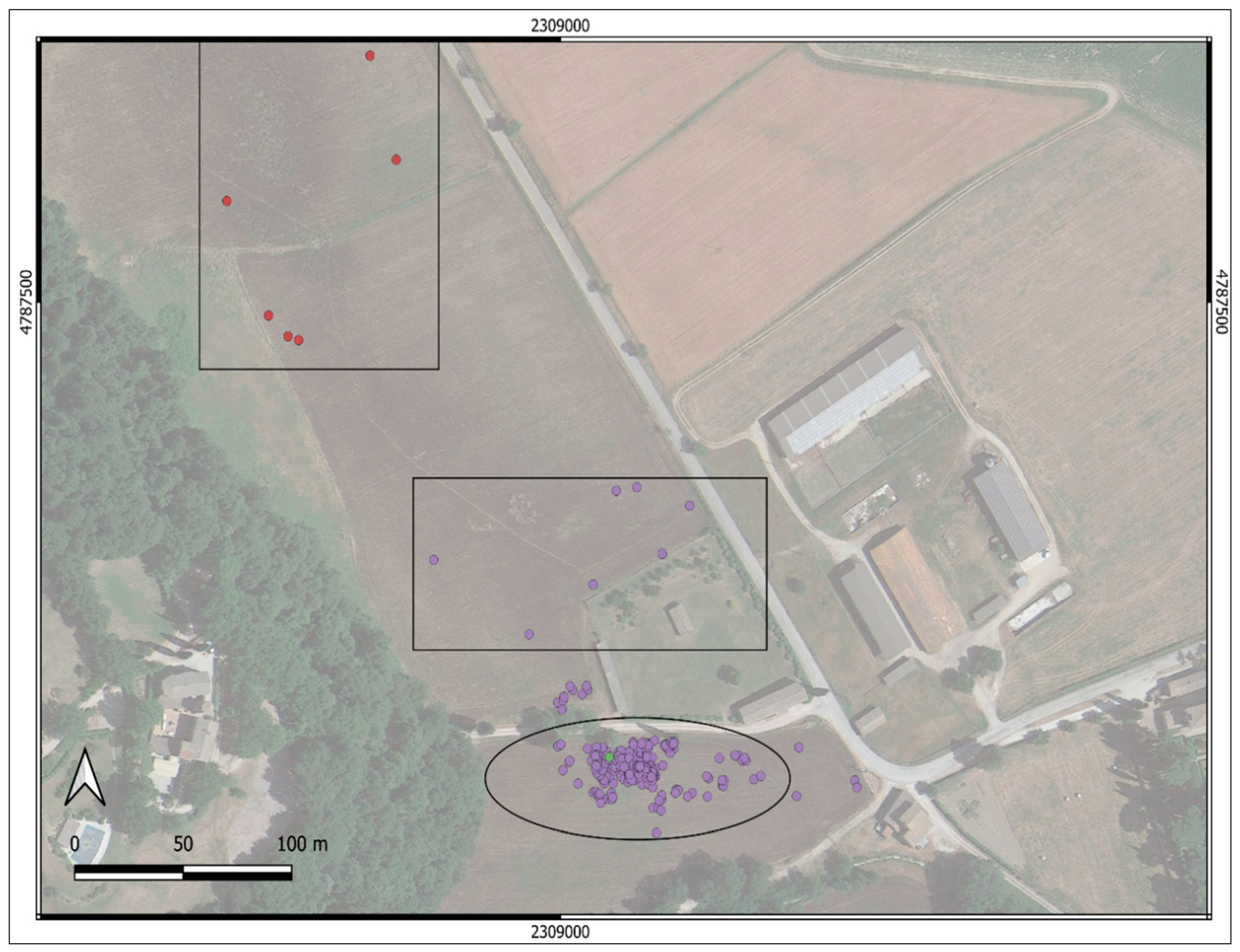
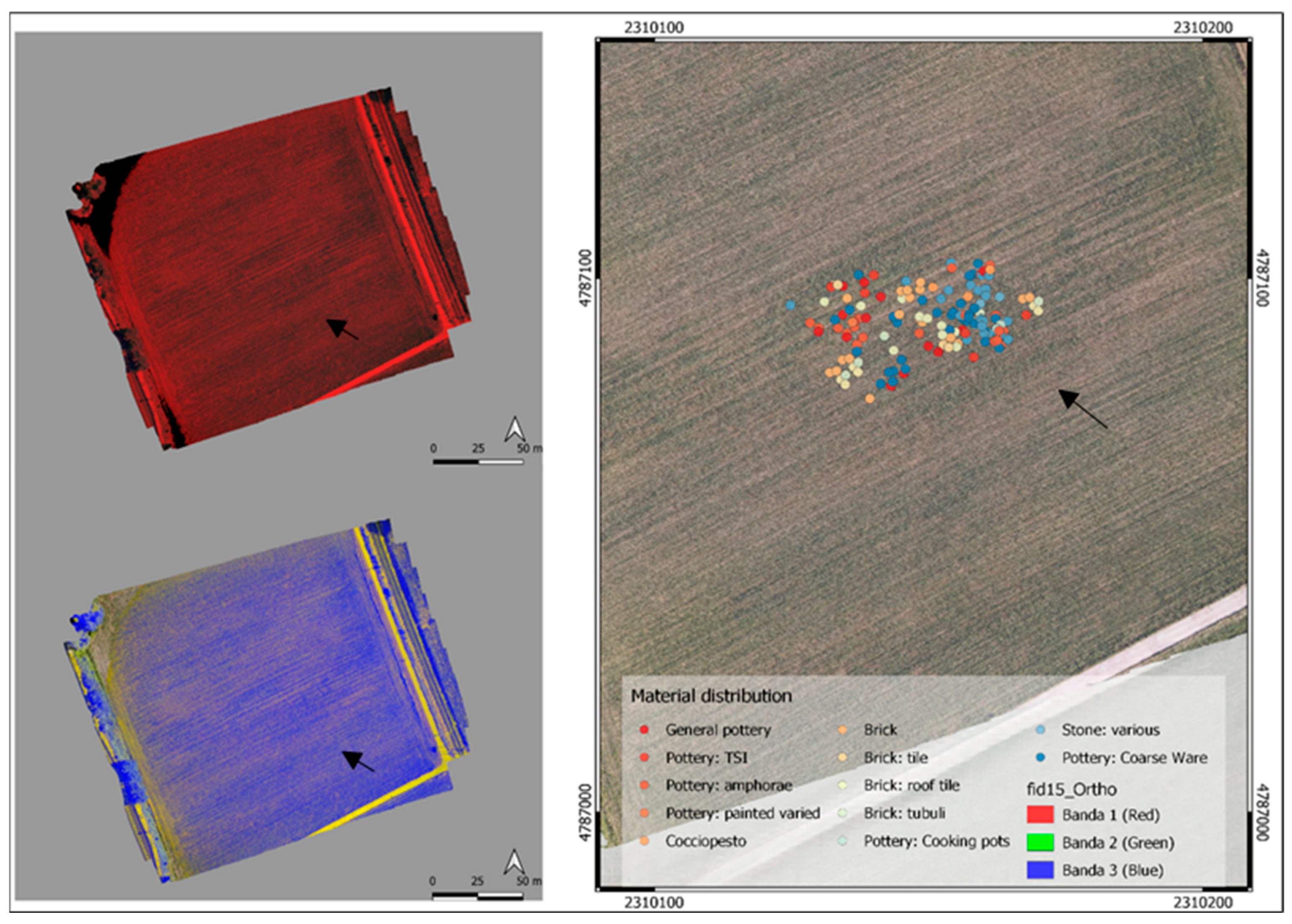
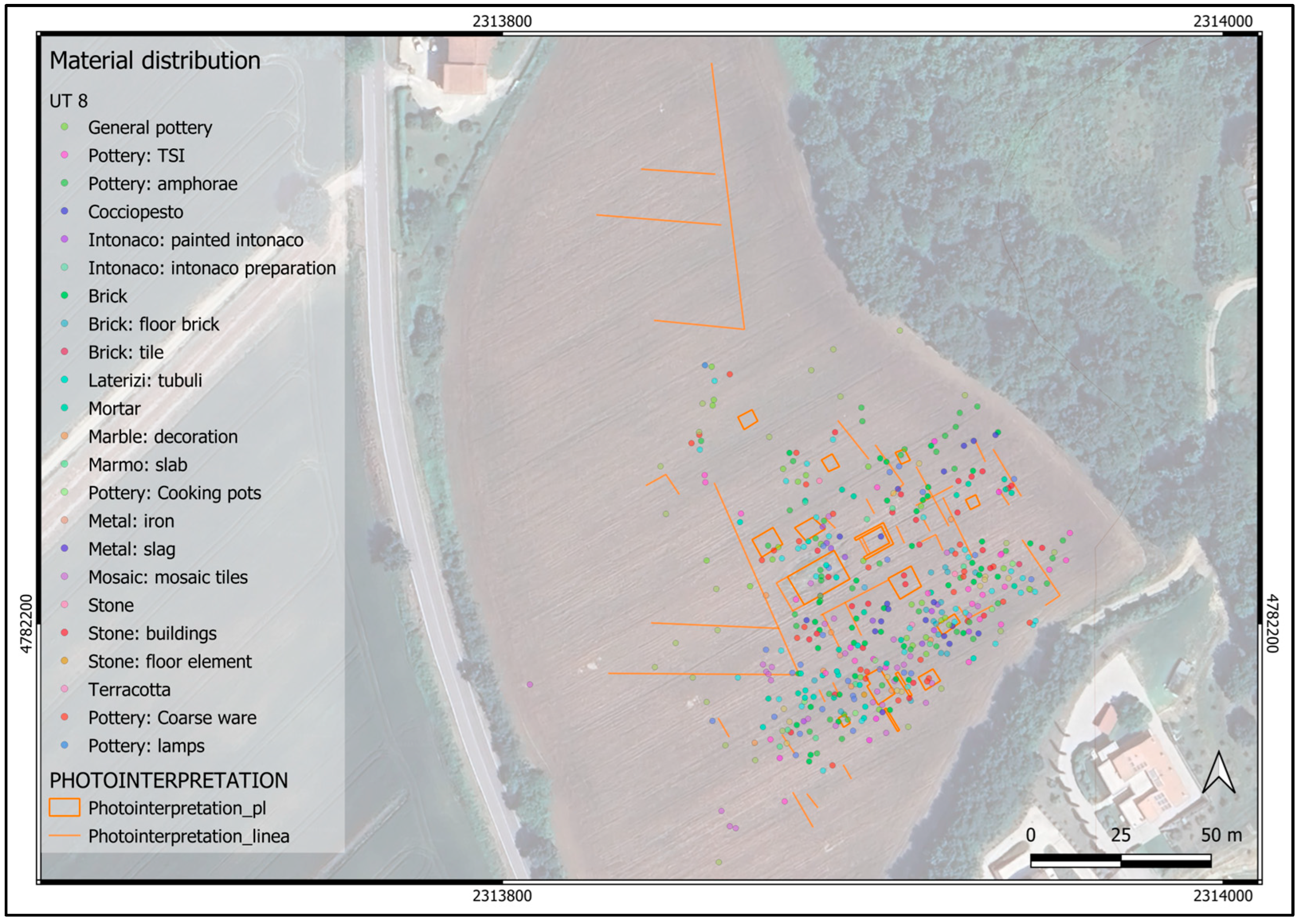
- “Ut_pt.gpkg” provides the layers with multipoint geometry, referring to the individual findings recovered in the survey in the years 2020 and 2021; each point corresponds to a finding collected or identified within the individual concentrations xzor in areas of holes [8] (p. 171). The information level provided a series of fields that were useful for identifying the single object collected, most of which were structured for value maps.
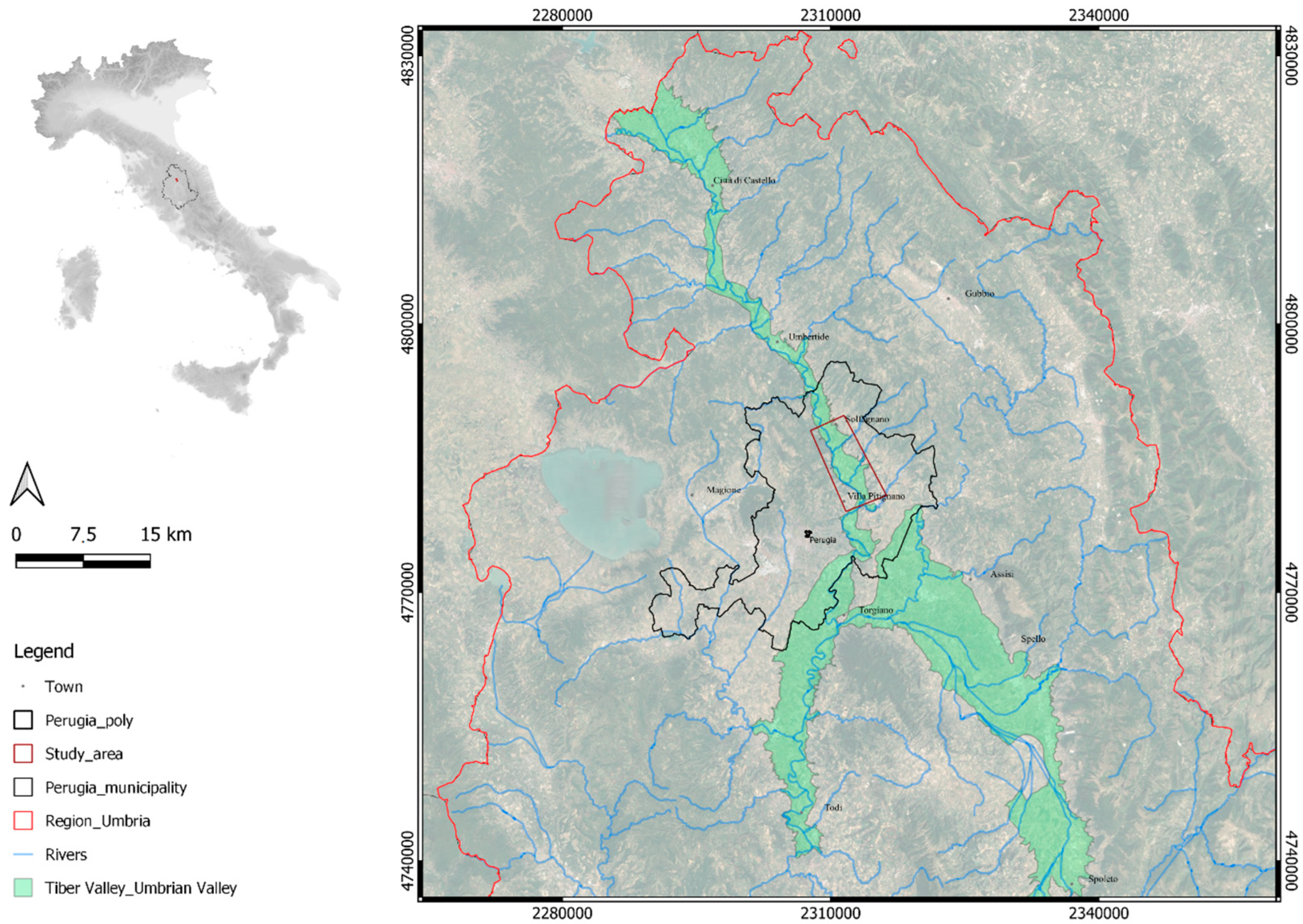
The Study Case
3. Results
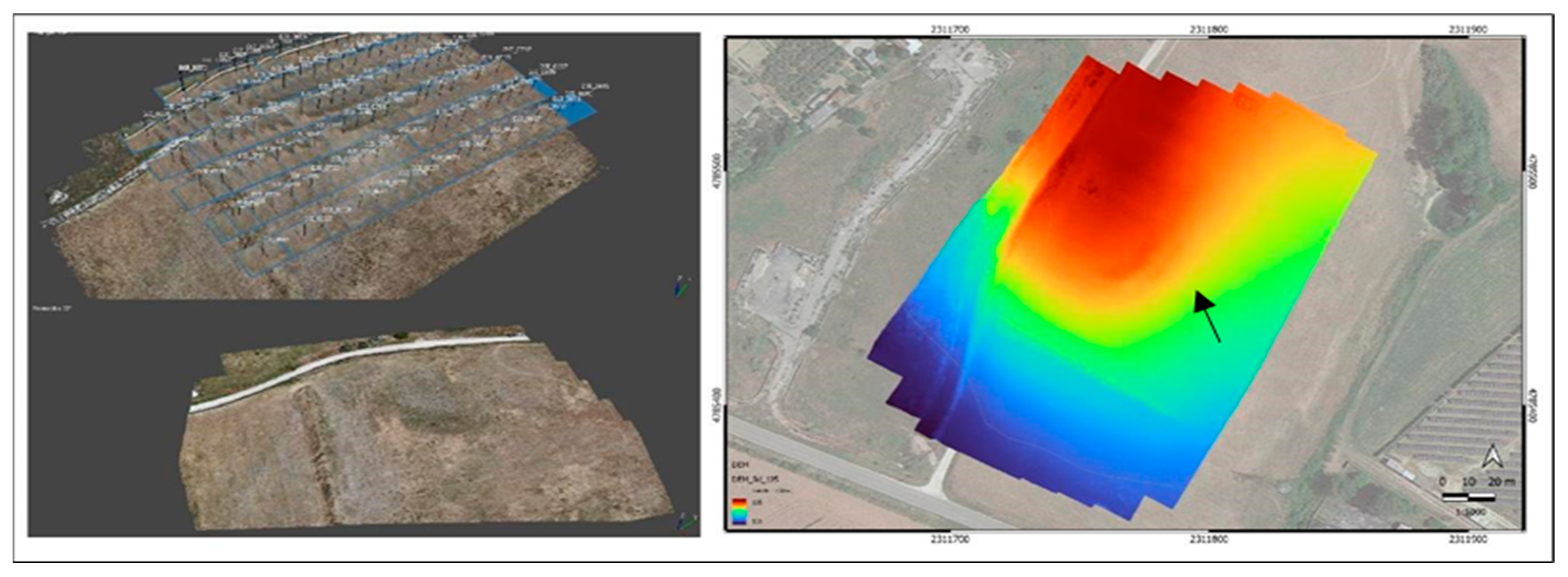
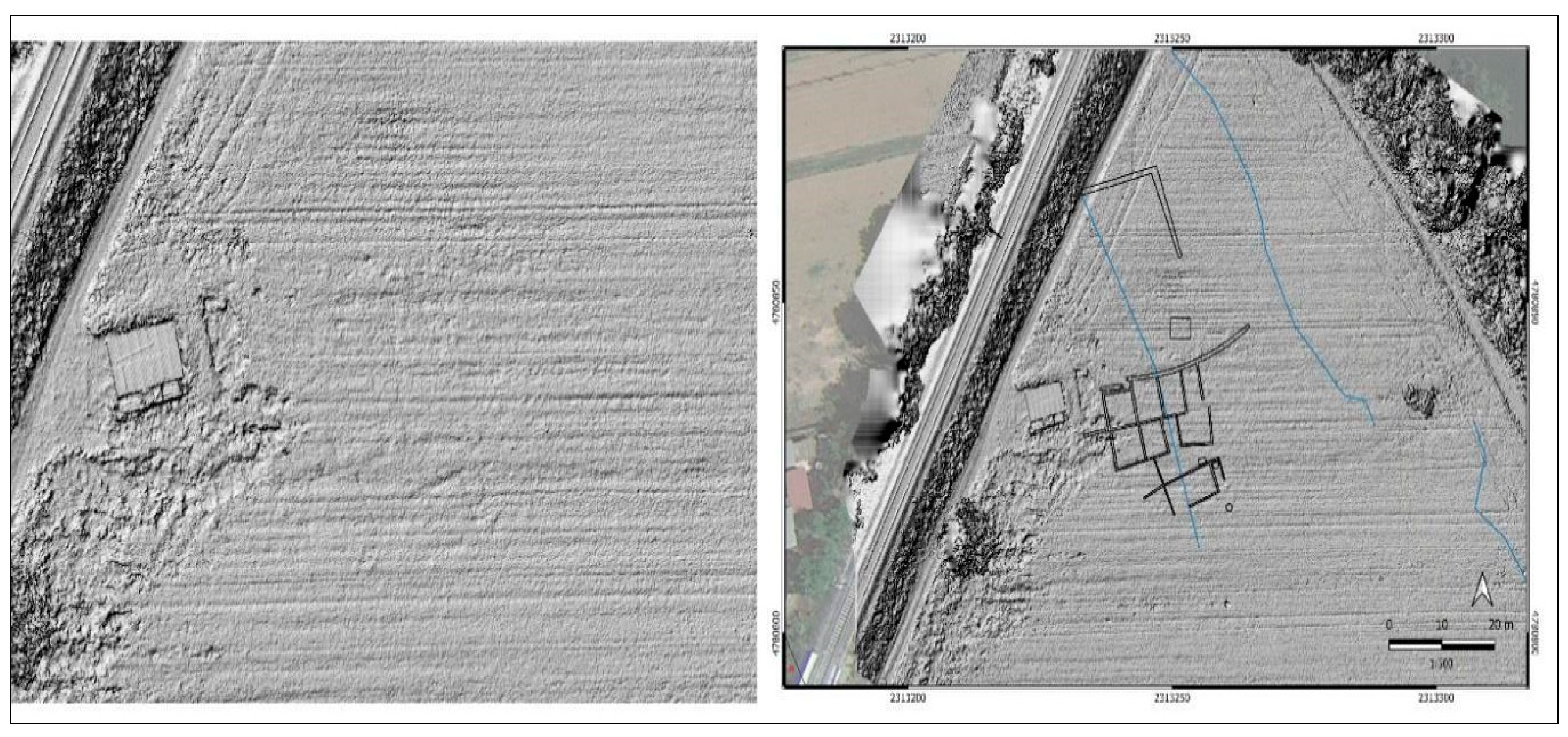
The Case Studies
4. Conclusions
Funding
Institutional Review Board Statement
Informed Consent Statement
Data Availability Statement
Conflicts of Interest
References and Notes
- Cambi, F.; Terrenato, N. Introduzione All’archeologia dei Paesaggi; Carocci: Roma, Italy, 1994. [Google Scholar]
- Cambi, F. Manuale di Archeologia dei Paesaggi. Metodologie, Fonti, Contesti; Carocci: Roma, Italy, 2011. [Google Scholar]
- Patterson, H. Bridging the Tiber. Approches to Regional Archaeology in the Middle Tiber Vallet; Archaeological Monographs of the British School at Rome: London, UK, 2004. [Google Scholar]
- Patterson, H.; Witcher, R.; Di Giuseppe, H. The Changing Landscapes of Rome’s Northern Hinterland. The British School at Rome’s Tiber Valley Project; Archeopress Roman Archaeology, 70; Archaeopress: Oxford, UK, 2020. [Google Scholar]
- Archivio di Stato di Perugia (A.S.P.), Ufficio Tecnico Erariale (U.T.E.), Catasto Chiesa, 1727.
- Campana, S. Catasto Leopoldino e GIS Technology: Metodologie, limiti e potenzialità, in Trame nello spazio. Quad. Geogr. Stor. Quant. 2023, 1, 71–78. [Google Scholar]
- Portal of Umbria Region. Available online: https://siat.regione.umbria.it/paesaggineltempo/ (accessed on 1 April 2020).
- Cirelli, E. Classificazione e quantificazione del materiale ceramico nelle ricerche di superficie. In Medioevo, Paesaggi e Metodi; Saggioro, F., Mancassola, N., Eds.; Documenti di Archeologia; SAP: Mantova, Italy, 2006; pp. 169–178. [Google Scholar]
- Montagnetti, R.; Guarino, G. Da Qgis a QField: Come la nuova applicazione Android sta agevolando il lavoro dell’archeologo. In FOSS4G-IT, Padova 20-23; Una Quantum Inc.: Roma, Italy, 2019. [Google Scholar]
- Montagnetti, R.; Guarino, G. From Qgis to Qfield and Vice Versa: How the New Android Application Is Facilitating the Work of the Archaeologist in the Field. Environ. Sci. Proc. 2021, 10, 6. [Google Scholar]
- Campana, S. Mapping the Continuum: Filling ‘Empty’ Meditteranean Landscapes; Springer: Berlin/Heidelberg, Germany, 2018. [Google Scholar]
- Belvedere, O. La ricognizione di superficie. Bilancio e prospettive. J. Anc. Topogr. 2010, 20, 31–40. [Google Scholar]
- Attema, P.; Bintliff, J.; Van Leusen, M.; Bes, P.; de Haas, T.; Donev, D.; Jongman, W.; Kaptijn, E.; Mayoral, V.; Menchelli, S.; et al. A guide to good practice in Mediterrean surface survey projects. J. Greek Archaeol. 2020, 5, 1–62. [Google Scholar] [CrossRef]
- Campana, S. Drones in Archaeology. State-of-the-art and Future Perspectives. Archaeol. Prospect. 2017, 24, 275–296. [Google Scholar] [CrossRef]
- Verhoeven, G.; Doneus, M.; Atzberger, C.; Wess, M.; Rus, M.; Pregesbauer, M.; Briese, C. New approaches for archaeological feature extraction of airborne imaging spectroscopy data. Archaeological prospection. In Proceedings of the 10th International Conference on Archaeological Prospection, Vienna, Austria, 29 May–2 June 2013; pp. 13–15. [Google Scholar]
- Nex, F.; Remondino, F. UAV 3D mapping applications: A review. Appl. Geomat. 2014, 6, 1–15. [Google Scholar] [CrossRef]
- Colomina, I.; Molina, P. Unmanned aerial systems for photogrammetry and remote sensing: A review. ISPRS J. Photogramm. Remote Sens. 2014, 92, 79–97. [Google Scholar] [CrossRef]
- Musson, C.; Palmer, R.; Campana, S. In volo nel passato. Aerofotografia e cartografia archeologica. In Air Photo Interpretation for Archaeologist; Wilson, D.R., Ed.; All’insegna del Giglio: Sesto Fiorentino, Italy, 1982. [Google Scholar]
- Piccaretta, F.; Ceraudo, G. Manuale di Aerofotografia Archeologica. Metodologia, Tecniche e Applciazioni; Edipuglia: Bari, Italy, 2000. [Google Scholar]
- Equipment Granted by Landscape Asrchaeology & Remote Sensing LAB. Available online: https://www.dssbc.unisi.it/it/ricerca/strutture-della-ricerca/laboratori/laboratorio-di-archeologia-dei-paesaggi-e-telerilevamento (accessed on 1 April 2020).
- Cenciaioli, L. Le necropoli perugine in prossimità del Tevere. In Marcator Placidissimus. The Tiber Valley in Antiquity. New Research in the Upper and Middle River Valley; Caorelli e H. Patterson, F., Ed.; Edizioni Quasar: Roma, Italy, 2004; pp. 387–398. [Google Scholar]
- This research is at the first step. Another application, much more timely and structured than now, will offer more details on the social and cultural complexity system.
- Ciarapica, A.; Manconi, D. Per una carta archeologica dell’Umbria nel quadro del Piano Paesaggistico regionale. In La Media e Alta Valle del Tevere dall’antichità al Medioevo (atti della Giornata di Studio, Umbertide, 26 maggio 2013); Scortecci, D., Ed.; Daidalos: Viterbo, Italy, 2014; pp. 19–23. [Google Scholar]
- Cenciaioli, L. Per una carta archeologica della diocesi di Perugia. In La Chiesa di Perugia nel Primo Millennio: Atti del Convegno di studi, Perugia, 1-3; Bartoli Langeli, A., Menestò, E., Eds.; Fondazione Centro Italiano di studi sull’alto Medioevo: Spoleto, Italy, 2005; pp. 211–230. [Google Scholar]
- Cenciaioli, L. Le testimonianze archeologiche. In Milites Templi. Esperienze di restauro degli edifici templari in Europa. La chiesa di S. Bevignate a Perugia; Comune di Perugia: Bologna, Italy, 2006; pp. 21–33. [Google Scholar]
Disclaimer/Publisher’s Note: The statements, opinions and data contained in all publications are solely those of the individual author(s) and contributor(s) and not of MDPI and/or the editor(s). MDPI and/or the editor(s) disclaim responsibility for any injury to people or property resulting from any ideas, methods, instructions or products referred to in the content. |
© 2024 by the author. Licensee MDPI, Basel, Switzerland. This article is an open access article distributed under the terms and conditions of the Creative Commons Attribution (CC BY) license (https://creativecommons.org/licenses/by/4.0/).
Share and Cite
Mandorlo, A. Discovering and Recording Archaeological Features during a Survey Using an Unmanned Aerial Vehicle and QField: Application and Integration for Studying the Countryside Surrounding Perugia, Umbria (Italy). Proceedings 2024, 96, 2. https://doi.org/10.3390/proceedings2024096002
Mandorlo A. Discovering and Recording Archaeological Features during a Survey Using an Unmanned Aerial Vehicle and QField: Application and Integration for Studying the Countryside Surrounding Perugia, Umbria (Italy). Proceedings. 2024; 96(1):2. https://doi.org/10.3390/proceedings2024096002
Chicago/Turabian StyleMandorlo, Alessia. 2024. "Discovering and Recording Archaeological Features during a Survey Using an Unmanned Aerial Vehicle and QField: Application and Integration for Studying the Countryside Surrounding Perugia, Umbria (Italy)" Proceedings 96, no. 1: 2. https://doi.org/10.3390/proceedings2024096002
APA StyleMandorlo, A. (2024). Discovering and Recording Archaeological Features during a Survey Using an Unmanned Aerial Vehicle and QField: Application and Integration for Studying the Countryside Surrounding Perugia, Umbria (Italy). Proceedings, 96(1), 2. https://doi.org/10.3390/proceedings2024096002


