Proceeding Paper

Assessment of Drought in Agricultural Areas by Combining Meteorological and Remote Sensing Data †

by
Ehsan Vazini Ahghar
,
Reza Shah-Hosseini
*,
Borzoo Nazari
,
Parisa Dodangeh
and
Seyyed Morteza Mousavi
School of Surveying and Geospatial Engineering, College of Engineering, University of Tehran, Tehran 1417466191, Iran
*
Author to whom correspondence should be addressed.
Presented at the 4th International Electronic Conference on Geosciences, 1–15 December 2022; Available online: https://sciforum.net/event/IECG2022.
Proceedings 2023, 87(1), 28; https://doi.org/10.3390/IECG2022-13960
Published: 30 May 2023
(This article belongs to the Proceedings of The 4th International Electronic Conference on Geosciences)

Abstract

:
Droughts during the growing season are projected to increase in frequency and severity in Iran. Thus, area-wide monitoring of agricultural drought in this region is becoming more and more important. Changes in precipitation patterns are caused by extreme weather events such as drought which strongly affect agricultural production. In this study, two data sources are used in drought assessment. First, by calculating the Standardized Precipitation Index (SPI) in the periods of 1 month, 3 months, 6 months, and one year in the western agricultural areas of Isfahan province in the time series from 2016 to 2019, precipitation data were used to analyze and evaluate meteorological drought’s spatial and temporal dynamics. Furthermore, the average loss of rainfall was calculated using TRMM satellite monthly rainfall data and the average NDVI monthly with Landsat 8 satellite images using remote sensing data. Then, the Composite Drought Index (CDI) is produced to assess agricultural drought in the 2017–2018–2019 time series. The correlation between the CDI and SPI varies between 0.19 and 0.81 in different months in the time series. The correlation between temperature and CDI in different months varies from 0.22 to 0.75 and between evaporation and CDI from 0.25 to 0.70 in the time series.

1. Introduction

Drought is a complex natural phenomenon caused by an imbalance of precipitation and evaporation. This crisis often occurs with a lack of rainfall and causes a decrease in soil moisture, which also affects plant growth in the long run [1]. Therefore, drought monitoring is vital to avert and reduce disasters and losses in the agricultural economy. In general, drought is associated with climatic events. Variables such as rainfall, temperature, and river flow can provide good indicators of the occurrence or non-occurrence of drought. After that, these indicators can be converted into drought indicators that indicate the occurrence, magnitude, intensity, and duration of the drought event [2]. Drought variables can contain an input or a combination of hydrological variables [3]. For this purpose, indices that are a combination of hydrological variables lead to better results; which variables to use depends on the situation and the type of drought being analyzed. In addition, the choice of drought index is determined based on the region of interest and data availability [4].
In recent decades, many indices such as Palmer Drought Severity Index (PDSI) [5], Standardized Precipitation Index (SPI) [6], and Standardized Precipitation Evapotranspiration Index (SPEI) [7] have been proposed and widely utilized for drought monitoring [8]. Most of the studies have emphasized that PDSI has been a good index for drought monitoring at the variate regions [9,10]. SPI is the precipitation-determining factor in the formation of drought, but does not consider the effects of temperature on drought, which is one of its limitations. In the following, some features of the two mentioned indices, such as the simplicity of calculation and multi-temporal nature of SPI, and the sensitivity to evaporation and transpiration of PDSI, were combined with each other to obtain the advantages of these two indices in one called SPEI. Many studies have used SPEI to analyze the spatiotemporal characteristics of drought in many regions [10,11]. In recent years, remote sensing data with wide spatial coverage has provided a good situation for extracting indicators and monitoring the spatial–temporal patterns of drought. An important finding from varied research is that Normalized Difference Vegetation Index (NDVI) can be used for vegetation drought conditions [12,13]. In this way, according to the definition of NDVI, a number of vegetation indices such as the Vegetation Condition Index (VCI) [14,15] and Enhanced Vegetation Index (EVI) [16] were created to detect drought. However, the vegetation index is closely related to vegetation greenness, and is often called the greenness index instead of the drought index [17]. Land surface temperature (LST) is sensitive to water content and soil moisture, while land cover types can strongly influence the relationship between LST and soil moisture [18]. This means that only using LST data for drought monitoring is not applicable when the study area has different types of land cover. For example, the Crop Water Stress Index (CWSI) [19,20] was only applicable to full vegetation areas [21]. Therefore, studies have worked on the integration of NDVI and LSI and concluded that this practice can provide more complete information about drought in bare soil than complete vegetation, and scientists have created many indices by combining LST and NDVI satellite data [22].
All the mentioned cases indicate the importance of continuous monitoring in susceptible areas; therefore, this research has focused on different goals in this field. These goals include: (a) Identifying minor spatial changes of drought using meteorological indices such as SPI and integration of indices such as NDVI and precipitation to assess agricultural drought. (b) Using parameters such as SPI, temperature data, and evaporation and transpiration obtained from synoptic stations to check the performance of the index used.

2. Materials and Methods

2.1. Study Area

The study area is located in the west of Isfahan province in Iran. Its geographical coordinates are longitude 49°38′00″ to 53°12′00″ and latitude 31°35′00″ to 32°58′00″, and its area is estimated to be 41,689 square meters. About 10% of the deserts in Iran are in Isfahan, and deserts make up about 33% of the area of this province. Figure 1 is the general display of the studied area.

2.2. Dataset

In this research, various remote sensing data including Landsat 8 OLI images for calculating monthly NDVI from 2016 to 2019 and TRMM monthly rainfall data were used. They were considered as input data for the combined index of agricultural drought. In addition, field data include precipitation, temperature, and evaporation data of synoptic stations located in the study area between 2016 and 2019. Synoptic station information can be seen in Table 1.

2.3. Proposed Method

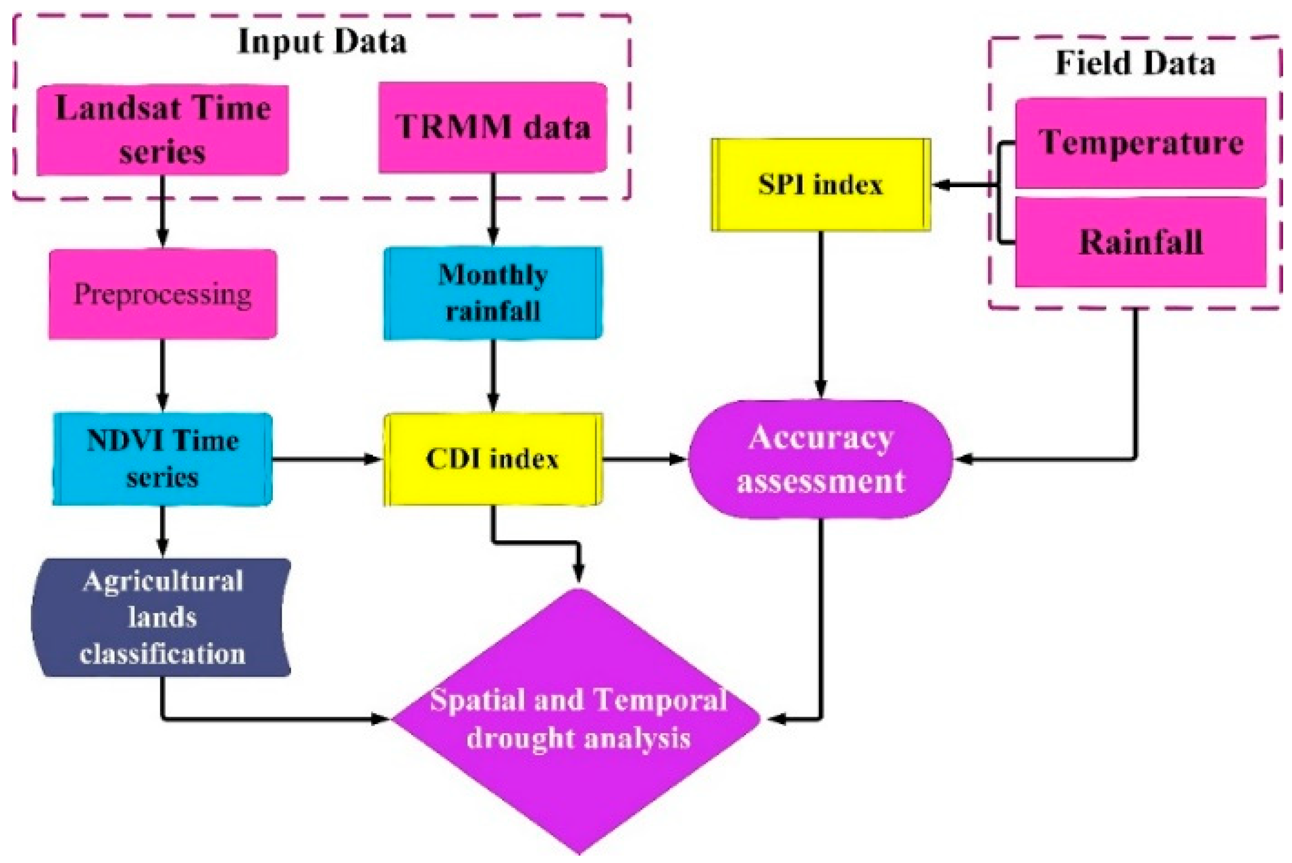
As mentioned, we tried to use field and satellite data for providing a valid composite index for agricultural drought assessment. The flowchart of the research is shown in Figure 2.

2.3.1. Identification of Agricultural Areas

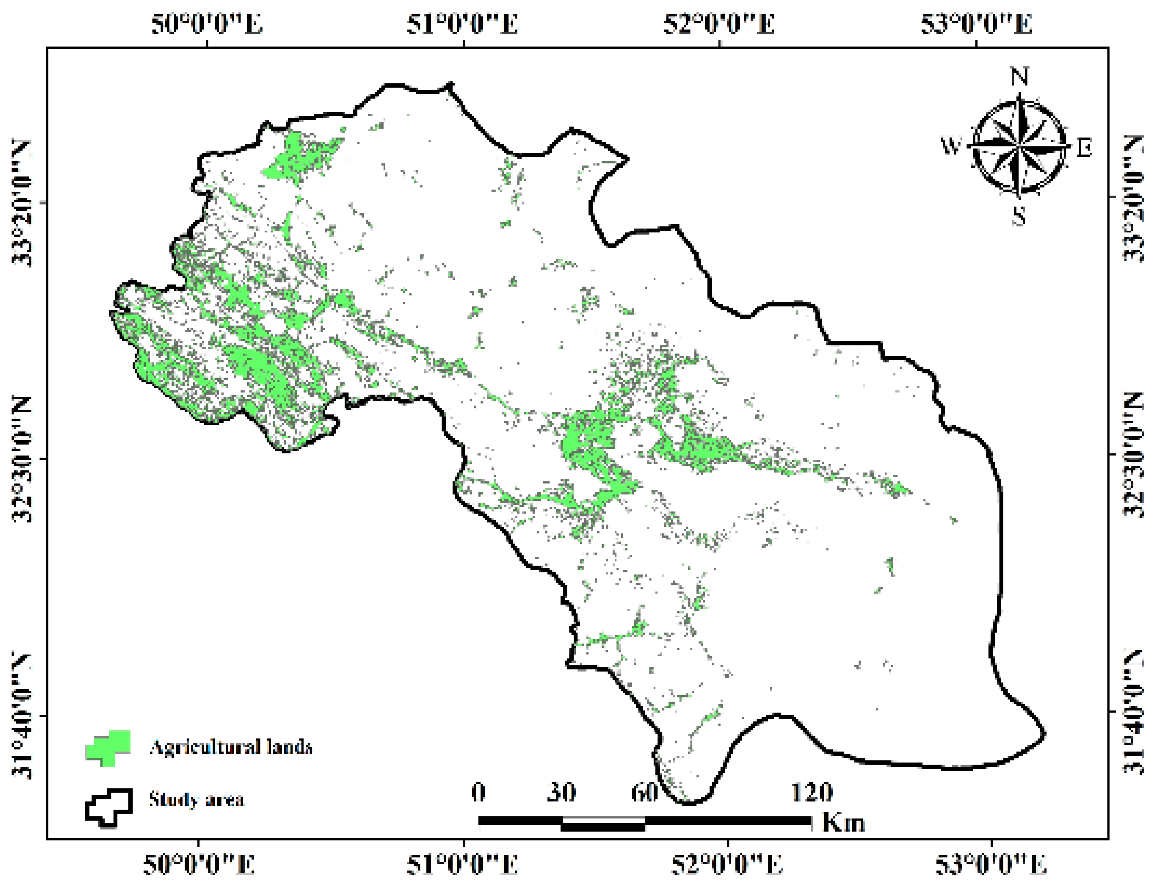
In this part, first, the Landsat images were preprocessed; then, in order to investigate the drought in the agricultural areas, NDVI time series for one crop year were obtained from the images and classified by applying the maximum likelihood algorithm; and, finally, the agricultural areas, both wet and dry, were separated. According to the prepared map in Figure 3, most of the agricultural areas are located in the northwest and center of the study area.

2.3.2. Standard Precipitation Index (SPI)

The Standard Precipitation Index was developed by McKee et al. [6]. One of the main advantages of the SPI is that it only requires precipitation data as an input, which makes it ideal for areas where data collection is not as extensive. The fact that the SPI is based solely on precipitation makes its evaluation relatively easy. The standardization of this index ensures independence from geographical position, as the index in question is calculated with respect to the average precipitation in the same place [23].

2.3.3. Composite Drought Index

Wisem et al. [24] created a Composite Drought Index (CDI) to evaluate multivariate droughts. The results showed that in comparison with univariate indices such as SPI, CDI provides a more comprehensive description of hidden variation in individual features of drought. In addition, it seems that the established CDI is a flexible and effective physical index that is dependent on the weather conditions of the studied region. In addition, this index is a combination of precipitation, discharge, and NDVI, the details of which are examined in [25].

2.3.4. Validation

Validation plays an important role in the performance of different algorithms which confirms the accuracy of the proposed approach. After creating CDI maps, accuracy assessment was performed by calculating the correlation between the CDI and the SPI and temperature and evaporation data as ground truths.

3. Implementation and Results

With attention paid to the high importance of drought and its high impact, this event was studied in the time series from 2016 to 2019 in the agricultural areas of west Isfahan. Moreover, in this section according to the description of Section 2.3, the results from the proposed approach have been examined.

3.1. SPI Results

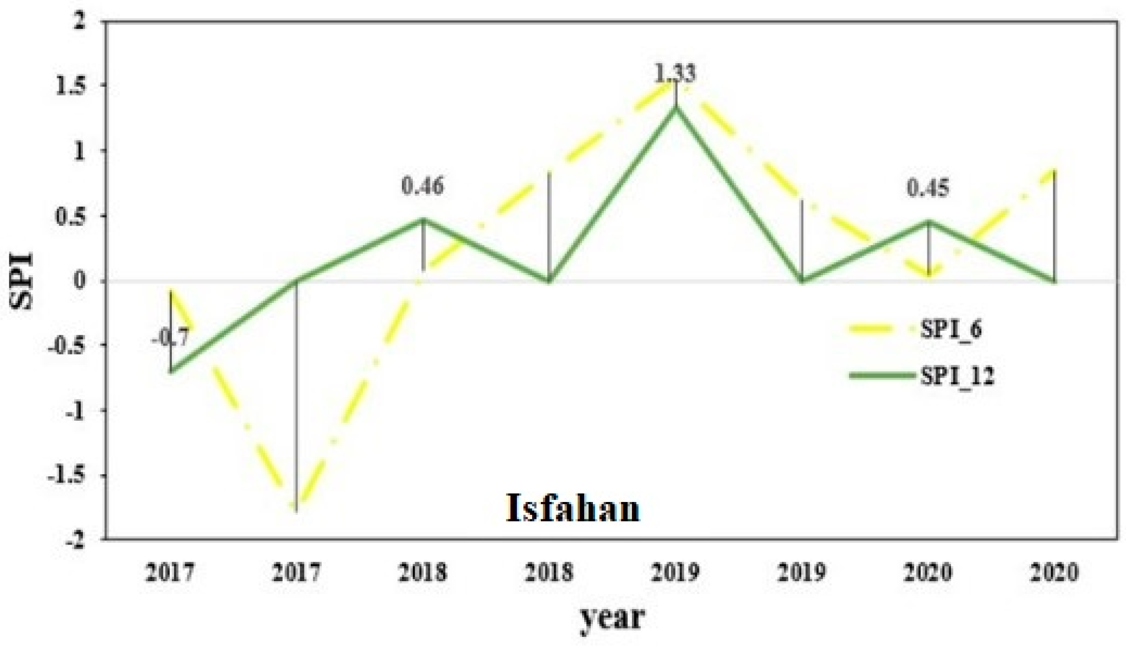
The index was calculated to identify the regular year between 2016 and 2019. The results show that we can consider 2016 as such, because neither drought nor wetness occurred. In addition, for the study of drought in the years 2017 to 2019, various time periods were considered. According to the results in this part, 2017 was the driest, 2019 was the wettest, and 2018 was the most normal year. Figure 4 shows a sample result of this index in the city of Isfahan in the period of six months and twelve months.

3.2. CDI Results

For a more detailed investigation of the drought in the western agricultural lands, in addition to the SPI, the CDI was estimated, which is a combination index of the amount of vegetation and rainfall of the area. When using the CDI, we should consider a year as a normal year and other years as a current year. In this study, 2017 to 2019 as the current year were considered to investigate the drought. As shown in Figure 5, the intensity of drought is higher in 2017 compared to 2018 and 2019, especially in the northwestern parts, which are agricultural lands. In 2018 and 2019, despite the occurrence of drought in the agricultural sectors, the intensity was much lower than in 2017.

3.3. Accuracy Assessment

In this section, necessary accuracy evaluations have been made to check the effectiveness of the proposed research approach.

3.3.1. Correlation between the CDI and SPI Indices

The correlation between the two indicators has been computed in various months during the years 2017 to 2019. Due to the large volume of results, only the correlation table calculated for 2017 and some of its months, which was the most important year in this research, is presented in Table 2.
Generally, the correlation of different monthly periods was between 0.19 to 0.81 in the distinct time series.

3.3.2. Correlation between CDI and Evaporation Field Data

In this section, the correlation between the CDI and evaporation in different months of 2017 to 2019 has been estimated, and some examples are presented in Table 3. As can be understood, the correlation between the various months is between 0.25 and 0.70. In some months, correlation has not been taken due to lack of data.

3.3.3. Correlation between the CDI and Temperature

Temperature is a good indicator of the energy balance on the earth’s surface, which is one of the key parameters in the physics of the earth’s surface processes on a regional and global scale. Moreover, it is an index that provides information about the soil moisture surface situation. In this section, correlation between drought index, CDI and temperature have been calculated. As can be seen in Table 4, these two studied data have a relatively good correlation.

4. Conclusions

Drought is the main problem of arid and semi-arid regions, and the great variation in the time and place of drought occurrence has made it difficult and complicated to accurately diagnose its occurrence based on spatial objectives [26]. Basically, for the quantitative analysis of drought, it is necessary to have a specific index to accurately determine wet and dry periods [27]. Due to the fact that meteorological drought indicators are only valid for one place, do not have the necessary spatial resolution, and are dependent on the information of meteorological stations which are often distributed far apart, the reliability of these indicators has been questioned. The characteristics of satellite data such as high spatial and temporal resolution, wide coverage of the studied areas, and direct investigation of the vegetation status by means of satellite indicators have caused many studies to be performed for drought modeling using this technology and related indicators [28]. In this study, the composite drought index (CDI) of rainfall and NDVI was investigated to evaluate the agricultural drought in the western region of Isfahan province using 4-year data (2016–2019) from remote sensing. This index was evaluated with the help of another index (SPI), as well as temperature and evaporation (E) during 3 years of drought. The results show the appropriate correlation between the CDI and validation data and the efficiency of the proposed approach in drought monitoring. Researchers are encouraged to try to use a longer time series to more accurately assess the drought in this region in future studies.

Author Contributions

Conceptualization, E.V.A.; R.S.-H.; B.N.; P.D. and S.M.M. methodology, software, validation, formal analysis, investigation, resources, data curation, writing—original draft preparation, writing—review and editing visualization, E.V.A.; R.S.-H.; B.N.; P.D. and S.M.M. supervision R.S.-H. All authors have read and agreed to the published version of the manuscript.

Funding

This research received no external funding.

Institutional Review Board Statement

Not applicable.

Informed Consent Statement

Not applicable.

Data Availability Statement

Not applicable.

Conflicts of Interest

The authors declare no conflict of interest.

References

  1. Senay, G.; Velpuri, N.M.; Bohms, S.; Budde, M.; Young, C.; Rowland, J.; Verdin, J. Drought monitoring and assessment: Remote sensing and modeling approaches for the famine early warning systems network. In Hydro-Meteorological Hazards, Risks and Disasters; Elsevier: Amsterdam, The Netherlands, 2015; pp. 233–262. [Google Scholar]
  2. Tirivarombo, S.; Osupile, D.; Eliasson, P. Drought monitoring and analysis: Standardised precipitation evapotranspiration index (SPEI) and standardised precipitation index (SPI). Phys. Chem. Earth Parts A/B/C 2018, 106, 1–10. [Google Scholar] [CrossRef]
  3. Hao, Z.; Singh, V.P. Drought characterization from a multivariate perspective: A review. J. Hydrol. 2015, 527, 668–678. [Google Scholar] [CrossRef]
  4. Smakhtin, V.U.; Schipper, E.L.F. Droughts: The impact of semantics and perceptions. Water Policy 2008, 10, 131–143. [Google Scholar] [CrossRef]
  5. Palmer, W.C. Keeping track of crop moisture conditions, nationwide: The new crop moisture index. Weatherwise 1968, 21, 156–161. [Google Scholar] [CrossRef]
  6. McKee, T.B.; Doesken, N.J.; Kleist, J. The relationship of drought frequency and duration to time scales. In Proceedings of the 8th Conference on Applied Climatology, Anaheim, CA, USA, 17–22 January 1993; pp. 179–183. [Google Scholar]
  7. Vicente-Serrano, S.M.; Beguería, S.; López-Moreno, J.I. A multiscalar drought index sensitive to global warming: The standardized precipitation evapotranspiration index. J. Clim. 2010, 23, 1696–1718. [Google Scholar] [CrossRef]
  8. Shi, S.; Yao, F.; Zhang, J.; Yang, S. Evaluation of temperature vegetation dryness index on drought monitoring over Eurasia. IEEE Access 2020, 8, 30050–30059. [Google Scholar] [CrossRef]
  9. Wang, Y.; Lu, R.; Ma, Y.; Sang, Y.; Meng, H.; Gao, S. Annual variation in PDSI since 1897 AD in the Tengger Desert, Inner Mongolia, China, as recorded by tree-ring data. J. Arid. Environ. 2013, 98, 20–26. [Google Scholar] [CrossRef]
  10. Yan, H.; Wang, S.Q.; Wang, J.B.; Lu, H.Q.; Guo, A.H.; Zhu, Z.C.; Myneni, R.B.; Shugart, H.H. Assessing spatiotemporal variation of drought in China and its impact on agriculture during 1982–2011 by using PDSI indices and agriculture drought survey data. J. Geophys. Res. Atmos. 2016, 121, 2283–2298. [Google Scholar] [CrossRef]
  11. Li, X.; Sha, J.; Wang, Z.-L. Comparison of drought indices in the analysis of spatial and temporal changes of climatic drought events in a basin. Environ. Sci. Pollut. Res. 2019, 26, 10695–10707. [Google Scholar] [CrossRef]
  12. Jain, S.K.; Keshri, R.; Goswami, A.; Sarkar, A.; Chaudhry, A. Identification of drought-vulnerable areas using NOAA AVHRR data. Int. J. Remote Sens. 2009, 30, 2653–2668. [Google Scholar] [CrossRef]
  13. Geng, L.; Ma, M.; Yu, W.; Wang, X.; Jia, S. Validation of the MODIS NDVI products in different land-use types using in situ measurements in the Heihe River Basin. IEEE Geosci. Remote Sens. Lett. 2014, 11, 1649–1653. [Google Scholar] [CrossRef]
  14. Kogan, F.N. Application of vegetation index and brightness temperature for drought detection. Adv. Space Res. 1995, 15, 91–100. [Google Scholar] [CrossRef]
  15. Kogan, F.N. Droughts of the late 1980s in the United States as derived from NOAA polar-orbiting satellite data. Bull. Am. Meteorol. Soc. 1995, 76, 655–668. [Google Scholar] [CrossRef]
  16. Huete, A.; Didan, K.; Miura, T.; Rodriguez, E.P.; Gao, X.; Ferreira, L.G. Overview of the radiometric and biophysical performance of the MODIS vegetation indices. Remote Sens. Environ. 2002, 83, 195–213. [Google Scholar] [CrossRef]
  17. Jackson, T.J.; Chen, D.; Cosh, M.; Li, F.; Anderson, M.; Walthall, C.; Doriaswamy, P.; Hunt, E.R. Vegetation water content mapping using Landsat data derived normalized difference water index for corn and soybeans. Remote Sens. Environ. 2004, 92, 475–482. [Google Scholar] [CrossRef]
  18. Son, N.T.; Chen, C.; Chen, C.; Chang, L.; Minh, V.Q. Monitoring agricultural drought in the Lower Mekong Basin using MODIS NDVI and land surface temperature data. Int. J. Appl. Earth Obs. Geoinf. 2012, 18, 417–427. [Google Scholar] [CrossRef]
  19. Idso, S.; Jackson, R.; Pinter, P., Jr.; Reginato, R.; Hatfield, J. Normalizing the stress-degree-day parameter for environmental variability. Agric. Meteorol. 1981, 24, 45–55. [Google Scholar] [CrossRef]
  20. Kumar, N.; Poddar, A.; Shankar, V.; Ojha, C.S.P.; Adeloye, A.J. Crop water stress index for scheduling irrigation of Indian mustard (Brassica juncea) based on water use efficiency considerations. J. Agron. Crop Sci. 2020, 206, 148–159. [Google Scholar] [CrossRef]
  21. Hu, X.; Ren, H.; Tansey, K.; Zheng, Y.; Ghent, D.; Liu, X.; Yan, L. Agricultural drought monitoring using European Space Agency Sentinel 3A land surface temperature and normalized difference vegetation index imageries. Agric. For. Meteorol. 2019, 279, 107707. [Google Scholar] [CrossRef]
  22. Carlson, T.N.; Perry, E.M.; Schmugge, T.J. Remote estimation of soil moisture availability and fractional vegetation cover for agricultural fields. Agric. For. Meteorol. 1990, 52, 45–69. [Google Scholar] [CrossRef]
  23. Belayneh, A.; Adamowski, J. Standard precipitation index drought forecasting using neural networks, wavelet neural networks, and support vector regression. Appl. Comput. Intell. Soft Comput. 2012, 2012, 6. [Google Scholar] [CrossRef]
  24. Snavely, K.N. Scene Reconstruction and Visualization from Internet Photo Collections; University of Washington: Seattle, WA, USA, 2008. [Google Scholar]
  25. Waseem, M.; Ajmal, M.; Kim, T.-W. Development of a new composite drought index for multivariate drought assessment. J. Hydrol. 2015, 527, 30–37. [Google Scholar] [CrossRef]
  26. Lin, M.; Chu, C.M.; Tsai, B. Drought risk assessment in western Inner-Mongolia. Int. J. Environ. Res. 2011, 5, 139–148. [Google Scholar]
  27. da Silva, V.D.P.R. On climate variability in Northeast of Brazil. J. Arid. Environ. 2004, 58, 575–596. [Google Scholar] [CrossRef]
  28. Gu, Y.; Brown, J.F.; Verdin, J.P.; Wardlow, B. A five-year analysis of MODIS NDVI and NDWI for grassland drought assessment over the central Great Plains of the United States. Geophys. Res. Lett. 2007, 34. [Google Scholar] [CrossRef]
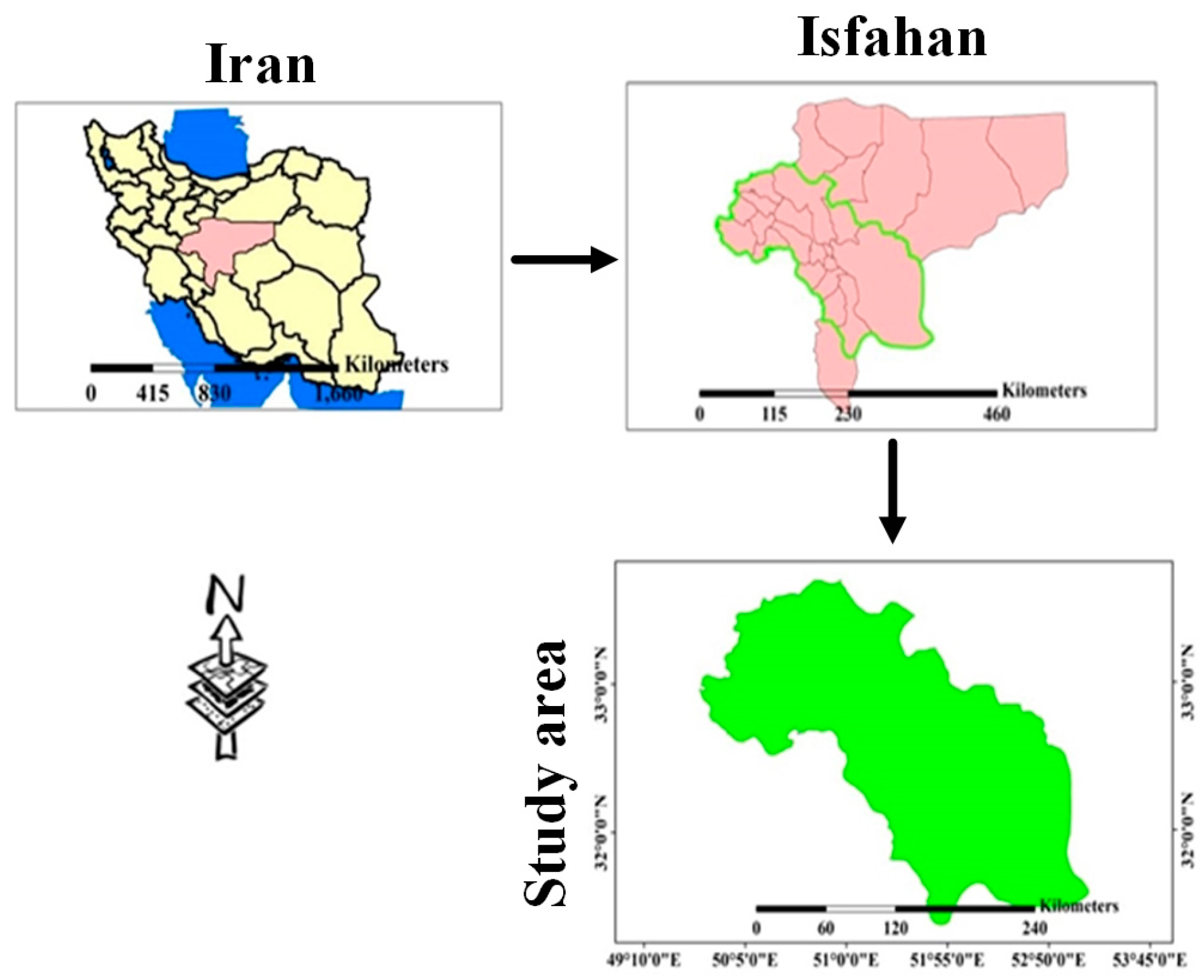
Figure 1. Location of study area.
Proceedings 87 00028 g001
Figure 2. Proposed method flowchart.
Proceedings 87 00028 g002
Figure 3. Agricultural lands in the study area.
Proceedings 87 00028 g003
Figure 4. Six− and twelve−month SPI of weather stations in Isfahan city.
Proceedings 87 00028 g004
Figure 5. Annual CDI of west Isfahan province; (a) year 2017, (b) year 2018, (c) year 2019.
Proceedings 87 00028 g005
Table 1. Information of synoptic stations used in the research.
Station NameLogLatElevation
Daran44081336477691563
Isfahan56633735979851550
Isfahan Airport58085636232551543
Golpaygan43340537032531850
Meymeh51549236993402012
Shahreza57657735386901859
Kabootar Abad57826935980121543
Table 2. Correlation between CDI and SPI in 2017.
SPISPI-1SPI-3SPI-6SPI-12
Month
Feb0.750.690.450.35
May0.650.300.190.69
Aug0.810.630.350.47
Dec0.680.630.650.42
Table 3. Correlation between CDI and evaporation.
Year201720182018
Month
Feb0.25--
Mar0.350.620.68
Apr0.570.420.39
Age0.550.70-
Dec-0.580.48
Table 4. Correlation between CDI and temperature.
Year201720182018
Month
Mar0.520.650.45
Apr0.480.420.39
Jun0.400.560.45
Age0.550.700.50
Dec0.350.400.55
Disclaimer/Publisher’s Note: The statements, opinions and data contained in all publications are solely those of the individual author(s) and contributor(s) and not of MDPI and/or the editor(s). MDPI and/or the editor(s) disclaim responsibility for any injury to people or property resulting from any ideas, methods, instructions or products referred to in the content.