Proceeding Paper

An Integrated Geoinformatics and Hydrological Modelling-Based Approach for Effective Flood Management in the Jhelum Basin, NW Himalaya †

1
Jammu and Kashmir Environmental Information System (ENVIS) Hub, Bemina Srinagar J&K-190018, India
2
Department of Ecology, Environment and Remote Sensing, Government of Jammu and Kashmir, Bemina Srinagar J&K-190018, India
3
Division of Agricultural Engineering, Sher-e-Kashmir University of Agricultural Sciences & Technology of Kashmir, Shalimar Campus, Srinagar J&K-190025, India
4
Department of Earth Sciences, University of Kashmir, Hazratbal Srinagar J&K-190006, India
*
Author to whom correspondence should be addressed.
Presented at the 3rd International Electronic Conference on Water Sciences, 15–30 November 2018; Available online: https://ecws-3.sciforum.net.
Proceedings 2019, 7(1), 8; https://doi.org/10.3390/ECWS-3-05804
Published: 15 November 2018
(This article belongs to the Proceedings of ECWS-3)

Abstract

:
In the present study, using static land system parameters, such as geomorphology, land cover, and relief, we calculated the water yield potential (RP) of all the watersheds of the Jhelum basin (Kashmir Valley) using the analytical hierarchy process (AHP) based watershed evaluation model (AHP-WEM). The results revealed that among the 24 watersheds of the Jhelum basin, the Vishav watershed, with the highest RP, is the fastest water yielding catchment of the Jhelum basin followed by Bringi, Lidder, Kuthar, Sind, Madhumati, Rembiara, Sukhnag, Dal, Wular-II, Romshi, Sandran, Ferozpur, Viji-Dhakil, Ningal, Lower Jhelum, Pohru, Arin, Doodganga, Arapal, Anchar, Wular-I, Gundar, and Garzan in the case of a same intensity storm event. The results were validated with the mean annual peak discharge values of the watersheds and a strong positive correlation of 0.71 was found. Further, for the forecasting of the floods in the watersheds that had a small lag time, such as in the case of Vishaw, Bringi, and Lidder, we evaluated the performance of the HEC-GeoHMS hydrological model to simulate stream discharge during storm events. It was observed that the model performs well for August-September period with a strong positive correlation (0.94) between the observed and simulated discharge and hence could be used as a flood forecasting model for this period in the region.

1. Introduction

South Asia is at the brunt of climate change related disasters. India particularly is witnessing 35 increased incidences of weather-related extreme events, such as floods, droughts, and heat waves [1]. In September 2014, Kashmir, the Northern Himalayan state of India, witnessed the most devastating flood in the recorded history of the region. Since 2014, the flooding threats in this region have been a recurring phenomenon every year [2]. The magnitude of this event crossed all bounds of the recorded history of floods in the region, not only in terms of discharge, but also in terms of loss of life and property [3,4,5,6]. The event has generated a scientific consensus for an alarming need of a robust flood mitigation strategy for the Kashmir region. Such an achievement for the region requires extensive data for three stages of research. First is the estimation of the contribution of the storm events within each of the 24 watersheds towards the discharge of the Jhelum River. For this, a dense network of automatic weather stations is required in each of the 24 watersheds of the Jhelum basin. The real time data can serve as input in the chosen calibrated hydrological model of the region. The model will reveal the peak of concentration or basin lag time that will serve as a warning for the downstream regions. Further, such a setup would also help in assessing the comparative basin lag times of the Jhelum watersheds, thus helping in prioritizing the watersheds for the construction of hydraulic structures that could help in extending the peak concentration, so that rapid concentrations of water in the Jhelum river that result in a huge wave of water to promulgate, as has been witnessed in the September 2014 floods, are delayed [3]. The third important step is the vulnerability assessment of the Jhelum basin, so that a final plan is drafted where people can be desisted from building structures in the flood prone areas or those who are already living in them could be resettled in safer zones [4,5,6].
Considering the gravity of the situation and the topographic complexity of the region, there is a need for an immediate flood assessment that could serve as a starting step of the mitigation strategy. The present research addresses the issue of the prioritization of the watersheds for a hydrological response that could reveal which watersheds of the Jhelum basin need immediate hydraulic or other overland flow (surface run-off) management strategies. This can be achieved with more sophisticated methodology as discussed above or an alternative empirical model may be developed, based on the geomorphology of the Jhelum basin. A good amount of literature exists on the relationships between geomorphological indices and the hydrological response. Altaf et al. (2012) assessed the hydrological response of the sub-watersheds of the west-Lidder watershed [7]. This study, based on morphometric parameters, evaluated the comparative hydrological response of the sub-watersheds and suggested which of the sub-watersheds of the 14 sub-watersheds of the west-Lidder watershed showed a quick hydrological response in the occurrence of a storm event. Meraj et al. (2015) assessed the comparatively hydrological response of the two watersheds of the Jhelum basin. This study evaluated a semi-quantitative index called the total run-off score (TR), based on the collective impact of morphometric parameters, land-cover, and slope categories on the hydrological response of the Lidder and Rembiara watersheds [5,6].
In the present study, using static land system parameters, such as geomorphology, land cover, and relief, we calculated the comparative water yield potential (RP) of all the watersheds of the Jhelum basin (Kashmir Valley) using the analytical hierarchy process (AHP) based watershed evaluation model (AHP-WEM) [8]. Further, we also tested the use of the HEC-GeoHMS (Hydrologic Engineering Center's Hydrologic Modeling System, HEC-HMS, Geospatial Hydrologic Modeling Extension) hydrological model for use as a flood forecasting model for the region [9]. We also generated a map of the locations wherein flood structural measures could be constructed as a management strategy to increase the lag time of the rapid water yielding watersheds.

2. Results

We used an integrated geoinformatics and hydrological based approach to holistically address the flooding problem in the Jhelum basin. Geoinformatics helped to deduce the highest water yielding watersheds of the Jhelum basin using the analytical hierarchy process (AHP) based watershed evaluation model (AHP-WEM). To come up with a flood forecast model for the Jhelum basin, we evaluated the performance of the HEC-GeoHMS hydrological model. Finally, we used GIS (Geographic Information System) based overlay analysis to find the locations for the construction of structural measures to manage floods in the affected watersheds. These results are shown below.

2.1. Analytical Hierarchy Process (AHP) Based Watershed Evaluation Model (AHP-WEM)

2.1.1. Watershed Morphometrics and Land Cover of Jhelum Basin Watersheds

Initially, we calculated 23 morphometric parameters to compensate for the geomorphology and relief of the 24 watersheds of the Jhelum basin. To reduce the redundancy in the information, we performed multivariate analysis on the data and as such, seven parameters were inferred that represented all the morphometric information of the watersheds [8]. For land cover, we generated eight land cover categories governing, in part, the hydrology of the Jhelum basin. The results revealed that among the 24 watersheds of the Jhelum basin, the Vishav watershed, with the highest runoff potential, is the fastest water yielding catchment of the Jhelum basin followed by Bringi, Lidder, Kuthar, Sind, Madhumati, Rembiara, Sukhnag, Dal, Wular-II, Romshi, Sandran, Ferozpur, Viji-Dhakil, Ningal, Lower Jhelum, Pohru, Arin, Doodganga, Arapal, Anchar, Wular-I, Gundar, and Garzan in the situation of a same intensity storm event. (Table 1, Figure 1).

2.1.2. Validation of AHP-WEM

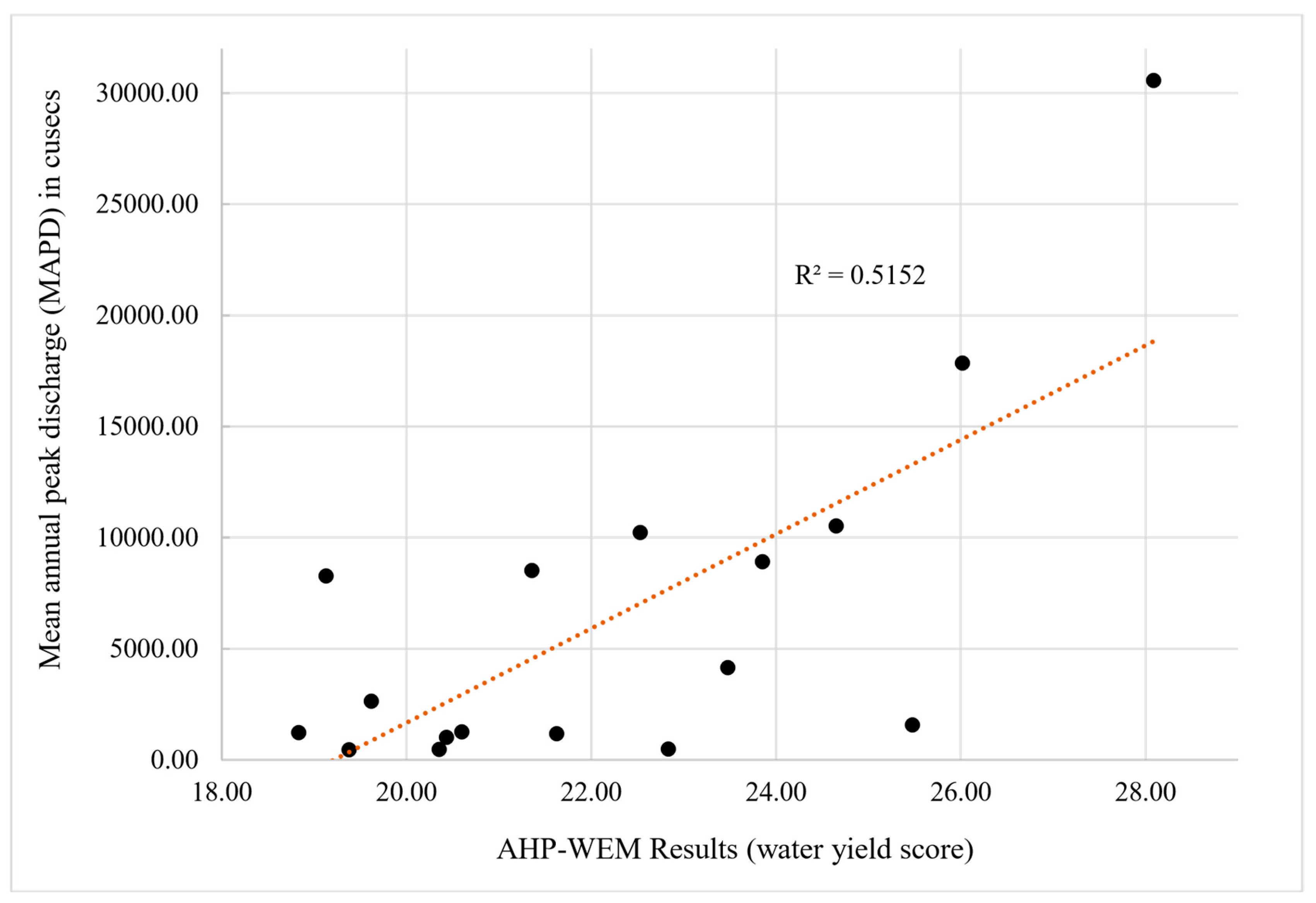
For the validation of the AHP-WEM results, we correlated the total water yield potential of the watersheds with the mean annual peak discharge (MAPD) values of the watersheds for 30 years. The results showed a strong positive correlation of 0.71 between the modelled water yield potential and the MAPD values of the watersheds (Figure 2).

2.2. HEC-GeoHMS Hydrological Model Simulations

We evaluated the performance of the HEC-GeoHMS model as a possible flood forecasting model for the Jhelum basin. It was observed that the model performs well for the August-September period with a strong positive correlation of 0.94 (r2 = 0.88) between the observed and simulated mean monthly discharge in the validation period (Aug–Sept, 2006–2016) (Figure 3). The model was run at the Sangam discharge station, which covers the Vishav, Bringi, Lidder, Kuthar and Sandran watersheds of the Jhelum basin for a period of 21 years (1995–2016) (Figure 1). The results inferred that this model is one of the good models freely available to the flood forecasters, when real time precipitation is available, to give an early warning and prevent disaster in the region.

2.3. GIS Overlay Analysis for the Determination of Structural Measures’ Locations

Using the slope, discharge density, and land cover information of the high water yielding watersheds, locations were determined for the construction of piano key-weirs and check dams as a management practice to delay surface runoff during heavy rains through GIS based overlay analysis. Finally, a location map was generated, showing areas where structural measures must be established to increase the basin lag time of the very high water yielding watersheds.

3. Discussion

The AHP-WEM model designed for this study uses the drainage characteristics and land cover information of the watersheds to characterize their water yield potential. The drainage system represents the geomorphology and lithology of the watershed very well [10]. Further, the type and distribution of the land cover (LC) directly controls the ambient soil moisture, infiltration, evapotranspiration, and interception processes of the hydrological cycle and thus directly controls the overland flow. Land cover is the major causal factor behind the frequency and occurrence of the floods in any region [11]. In this study, the morphometry and LC (Land Cover) of all the Jhelum basin watersheds were used to understand their comparative water yield potential. It was observed that the south Jhelum watersheds (South Kashmir) have a very high water yield potential, which results in them being very fast at discharging their water after a heavy downpour. This is one of the reasons behind the initial heavy flooding of the south Kashmir villages prior to the overall flooding of the whole Kashmir valley during the 2014 deluge. The HEC-GeoHMS hydrological model was used to infer its applicability for near real-time flood forecasting at Sangam where almost all the very high water yielding watersheds collate (Figure 1). Model calibration was performed for a range of parameters, such as the CN (Runoff Curve Number)) and Muskingum. After lot of initial calibrations, the model was set up at r2 = 0.87 for calibration and r2 = 0.88 for validation. Further, for effective flood management, it is necessary that flood control structural measures are set up at locations where the abrupt inflow of water can be managed to delay the concentration of water at downstream locations for early warnings and the evasion of disasters. For this purpose, the drainage density and land cover layers were used to deduce such locations using overlay analysis. Areas with heavy drainage density and vulnerable land cover, such as impervious surfaces and degraded land, were ranked high in the analysis [12].

4. Materials and Methods

The comparative water yield potential of the 24 watersheds of the Jhelum basin was evaluated from the analysis of the morphometric indices and the land cover of the basin watersheds in an AHP based watershed evaluation model (AHP-WEM). We used a survey of India’s (SOI) topographic maps (1:50,000 scales), Indian Remote Sensing (IRS) P6 Linear Imaging Self-Scanning (LISS III) data with a 23.5 m spatial resolution from 21 October 2008, and the Advanced Space-borne Thermal Emission and Reflection Radiometer (ASTER) 30-m resolution Digital Elevation Model (DEM) in the AHP-WEM model. For HEC-GeoHMS, soil maps from the National Bureau of Soils Sciences & Land Use Planning (NBSS&LUP) at 1:250,000 served as base line data. The daily rainfall for period of 1995 till 2016 of the Kokernag, Qazigund, and Pahalgam stations, and the mean monthly discharge data for the same period at the Sangam station was used to set up the model.
The AHP-WEM model is based on the following equations:
In AHP, the normalized principal Eigen vector that was used as a weighting coefficient for the analysis is calculated using the following formula:
W = i = 1 n i / N
where:
  • >Wi is the principal Eigen vector or the weighting coefficient.
  • i>i = parameter.
  • i>N = total number of parameters.
To make sure that the original preference or ratings are consistent, Saaty (2000) devised a consistency index (CI) and consistency ratio (CR) defined by the following formulae:
C I = λ max n n 1
C R = C I R I
where:
  • λmax is the average of the consistency measure of all the parameters.
  • n is the total number of the parameters in a matrix.
  • RI is the random consistency index developed by Saaty (1990, 2008) for different matrix orders from 1 to 15. Consistency ratio (CR) must be less than 0.1 for a matrix to be consistent. In the present study, the CR was calculated to be equal to 0.8 for the both morphometry and land cover matrices and shows that the ratings used in the pairwise comparison matrix were consistent [13,14,15].
The water yield potential equation (AHP-WEM), as follows:
R I = i = 1 n W R S
W R S = W . R S
where:
  • RI = Run off index of the watershed and is the sum of both the morphometric and land cover parameters.
  • WRSi = AHP (analytical hierarchy process) weightage-based score of a parameter of a watershed.
  • Wi = Pairwise comparison derived weight of the parameter.
  • RSi = Run off score of the watershed for a given parameter.
  • i>n = Number of parameters of the watershed.
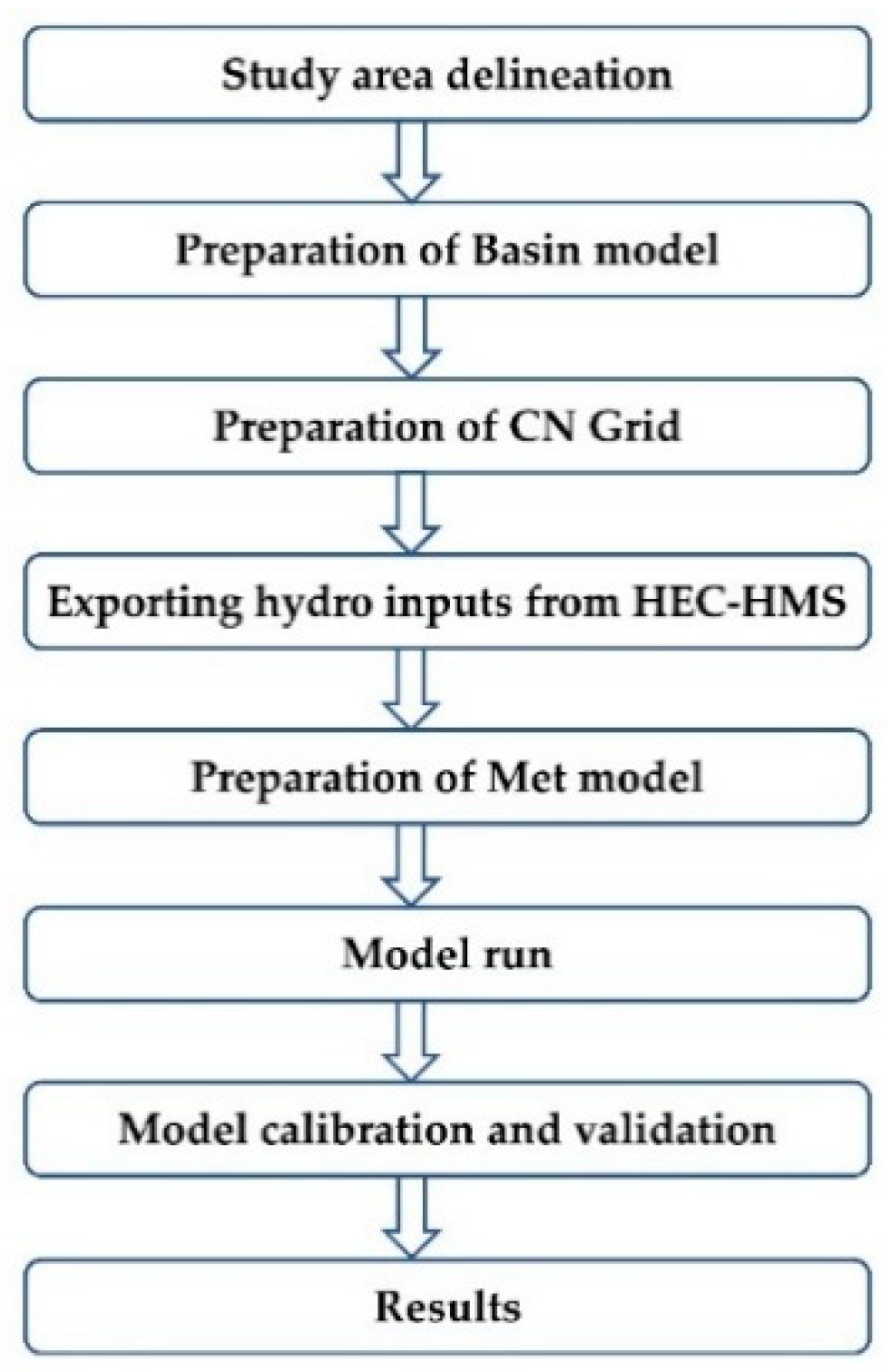
The overall methodology of the HEC-GeoHMS model is shown in Figure 4.

5. Conclusions

The three-tier strategy used in this work starting from determining, comparatively, the highest 207 water yielding watersheds to finding the most effective and efficient locations for structural flood control measures paves the way for disaster managers of the region to deal with the recurring floods of the region. The very high water yielding watersheds must be managed on a priority basis and a dense network of automatic weather stations must be established for near real time flood forecasting using the HEC-GeoHMS model. The integrated use of geoinformatics and hydrological modeling in this study focused on the holistic flood management of the Jhelum basin and paves the way for further research in this area.

Author Contributions

G.M. conceptualized the methodology, did the AHP-WEM analysis, prepared the maps and wrote the manuscript; T.K. performed the HEC-GeoHMS modelling in assistance with B.A.S.; S.A.R., M.F. and K.R. conceptualized the methodology and helped in the preparation of the manuscript.

Acknowledgments

This research work has been accomplished under the research grants provided by, (1) Department of Science and Technology, Government of India (DST-GOI) for the project titled “National Himalayan Mission for Sustainable Himalayan Ecosystem; Climate Change Centre, Jammu and Kashmir, (DST/SPLICE/CCP/NMSHE/IHR-State-03/2014(G)”, (2) Ministry of Environment and Forests (MOEF) sponsored scheme titled, “Environment Information System (ENVIS), Jammu and Kashmir centre, (109351/AS&FA/2018)”,and (3) Department of Science and Technology, Government of India (DST-GOI) for the project titled “Integrated Flood vulnerability Assessment for Flood Risk Management and Disaster Mitigation.” The authors express their gratitude to the funding agencies for the financial assistance. Finally, we would like to thank two anonymous reviewers for their valuable suggestions that greatly improved the quality of this manuscript.

Conflicts of Interest

The authors declare no conflict of interest.

Abbreviations

The following abbreviations are used in this manuscript:
AHPAnalytical Hierarchical Process
WEMWatershed Evaluation Model
HEC-GeoHMSHydrologic Engineering Center—Geographic Hydrologic Modeling System
MAPDMean annual peak discharge
GISGeographic Information System
SOIsurvey of India
IRSIndian Remote Sensing Satellite
ASTERAdvanced Space-borne Thermal Emission and Reflection Radiometer
DEMDigital Elevation Model
NBSS&LUPNational Bureau of Soils Sciences & Land Use Planning

References

  1. Gujree, I.; Wani, I.; Muslim, M.; Farooq, M.; Meraj, G. Evaluating the variability and trends in extreme climate events in the Kashmir Valley using PRECIS RCM simulations. Model. Earth Syst. Env. 2017. [Google Scholar] [CrossRef]
  2. Bhat, M.S.; Alam, A.; Ahmad, B.; Kotlia, B.S.; Farooq, H.; Taloor, A.K.; Ahmad, S. Flood frequency analysis of river Jhelum in Kashmir basin. Quat. Int. 2018. [Google Scholar] [CrossRef]
  3. Bhatt, C.M.; Rao, G.S.; Farooq, M.; Manjusree, P.; Shukla, A.; Sharma, S.V.S.P.; Kulkarni, S.S.; Begum, A.; Bhanumurthy, V.; Diwakar, P.G.; et al. Satellitebased assessment of the catastrophic Jhelum floods of September 2014, Jammu & Kashmir, India. Geomatics Nat. Hazards Risk 2017, 8, 309–327. [Google Scholar]
  4. Meraj, G.; Yousuf, A.R.; Romshoo, S.A. Impacts of the Geo-environmental Setting on the Flood Vulnerability at Watershed Scale in the Jhelum Basin. Ph.D. dissertation, University of Kashmir, Jammu and Kashmir, India, 2013. Ph.D. dissertation, University of Kashmir, Jammu and Kashmir, India, 2013. [Google Scholar]
  5. Meraj, G.; Romshoo, S.A.; Yousuf, A.R.; Altaf, S.; Altaf, F. Assessing the influence of watershed characteristics on the flood vulnerability of Jhelum basin in Kashmir Himalaya. Nat. Hazards 2015, 77, 153–175. [Google Scholar] [CrossRef]
  6. Meraj, G.; Romshoo, S.A.; Yousuf, A.R.; Altaf, S.; Altaf, F. Assessing the influence of watershed characteristics on the flood vulnerability of Jhelum basin in Kashmir Himalaya: Reply to comment by Shah 2015. Nat. Hazards 2015, 78, 1–5. [Google Scholar] [CrossRef]
  7. Altaf, F.; Meraj, G.; Romshoo, S.A. Morphometric analysis to infer hydrological behaviour of Lidder watershed, Western Himalaya, India. Geogr. J. 2013, 2013, 178021. [Google Scholar] [CrossRef]
  8. Meraj, G.; Romshoo, S.A.; Ayoub, S.; Altaf, S. Geoinformatics based approach for estimating the sediment yield of the mountainous watersheds in Kashmir Himalaya, India. Geocarto Int. 2018, 33, 11141138. [Google Scholar] [CrossRef]
  9. Hicks, F.E.; Peacock, T. Suitability of HEC-RAS for flood forecasting. Can. Water Resour. J. 2005, 30, 159–174. [Google Scholar] [CrossRef]
  10. Ifabiyi, I.P.; Eniolorunda, N.B. Watershed characteristics and their implication for hydrologic response in the upper Sokoto basin, Nigeria. J. Geogr. Geol. 2012, 4, 147. [Google Scholar]
  11. Javed, A.; Khanday, M.Y.; Ahmed, R. Prioritization of subwatersheds based on morphometric and landuse analysis using remote sensing and GIS techniques. J. Indian Soc. Remote Sens. 2009, 37, 261–274. [Google Scholar] [CrossRef]
  12. Rather, M.A.; Farooq, M.; Meraj, G.; Dada, M.A.; Sheikh, B.A.; Wani, I.A. Remote sensing and GIS based forest fire vulnerability assessment in Dachigam National park, North Western Himalaya. Asian J. Appl. Sci. 2018, 11, 98–114. [Google Scholar] [CrossRef]
  13. Saaty, T.L. How to make a decision: The analytic hierarchy process. Eur. J. Oper. Res. 1990, 48, 9–26. [Google Scholar] [CrossRef]
  14. Saaty, T.L. Decision making with the analytic hierarchy process. Int. J. Serv. Sci. 2008, 1, 83–98. [Google Scholar] [CrossRef]
  15. Altaf, S.; Meraj, G.; Romshoo, S.A. Morphometry and land cover based multi-criteria analysis for assessing the soil erosion susceptibility of the western Himalayan watershed. Environ. Monit. Assess. 2014, 186, 8391–8412. [Google Scholar] [CrossRef] [PubMed]
Figure 1. Comparative water yield potential categories of the Jhelum basin watersheds.
Proceedings 07 00008 g001
Figure 2. Scatterplot of MAPD (mean annual peak discharge) and AHP-WEM model results.
Proceedings 07 00008 g002
Figure 3. HEC-GeoHMS results of the validation period (Aug–Sept), 2006–2016.
Proceedings 07 00008 g003
Figure 4. HEC-GeoHMS methodology including the basin model generation and preparation of the CN (curve number) grid followed by the met model preparation.
Proceedings 07 00008 g004
Table 1. Water yield potential categorization of Jhelum basin watersheds based on the AHP-WEM (analytical hierarchy process (AHP) based watershed evaluation model) results.
S no.WatershedAHP-WEM TR ScoreWater YieldS no.WatershedAHP-WEM TR ScoreWater Yield
1Garzan13.03Low13Sandran21.36High
2Gundar15.99Low14Romshi21.63High
3WularI18.11Medium15WularII22.37High
4Anchar18.83Medium16Dal22.53High
5Arapal18.83Medium17Sukhnag22.83High
6Doodganga19.13Medium18Rembiara23.33High
7Arin19.38Medium19Madhumati23.48High
8Pohru19.62Medium20Sind23.86High
9Lower Jhelum20.11Medium21Kuthar24.65Very high
10Ningal20.35Medium22Lidder25.48Very high
11Viji-Dhakil20.43Medium23Bringi26.02Very high
12Ferozpur20.60High24Vishav28.09Very high