Proceeding Paper

UAV Trajectory Management: Ardupilot Based Trajectory Management System †

by
Javier Losada Pita
1,* and
Félix Orjales Saavedra
2
1
Navantia-UDC Joint Research Unit, University of A Coruña, 15403 Ferrol, Spain
2
Integrated Group for Engineering Research, University of A Coruña, 15403 Ferrol, Spain
*
Author to whom correspondence should be addressed.
Presented at the 2nd XoveTIC Conference, A Coruña, Spain, 5–6 September 2019.
Proceedings 2019, 21(1), 8; https://doi.org/10.3390/proceedings2019021008
Published: 23 July 2019
(This article belongs to the Proceedings of The 2nd XoveTIC Conference (XoveTIC 2019))

Abstract

:
In this paper we explain the structure and development of a trajectory management system on board a UAV capable to achieve complex trajectories and versatile to adapt disturbances during flight. This system is built in Python and runs in a companion computer on board the UAV while maintains communication with a ground station over a radio link.

1. Introduction

UAV operations are growing fast the last years due to the versatility they offer [1]. They can perform diverse kind of missions, from aerial photography to long distances deliveries. These missions all can be benefited by a system capable to control a trajectory to maintain an autonomous flight adapting his behavior in real time to variable conditions like wind, obstacles, vehicle failures, No fly zones, etc. These conditions can lead, in the worst scenario, to the loss of the vehicle which would lead to economic losses and a large safety problem when flying over populated areas.
Usually UAV autonomous missions consist of a series of waypoints preprogrammed which the flight controller will try to follow no matter what happens until the mission is complete or the pilot manually cancels the mission. This increases the likelihood that a mission will not perform successfully due to external disturbances [2]. In this paper we develop a trajectory management system capable to adapt to changing flight conditions gathering data from the surroundings with sensors connected to the companion computer (cameras, Lidars, radars, etc.).

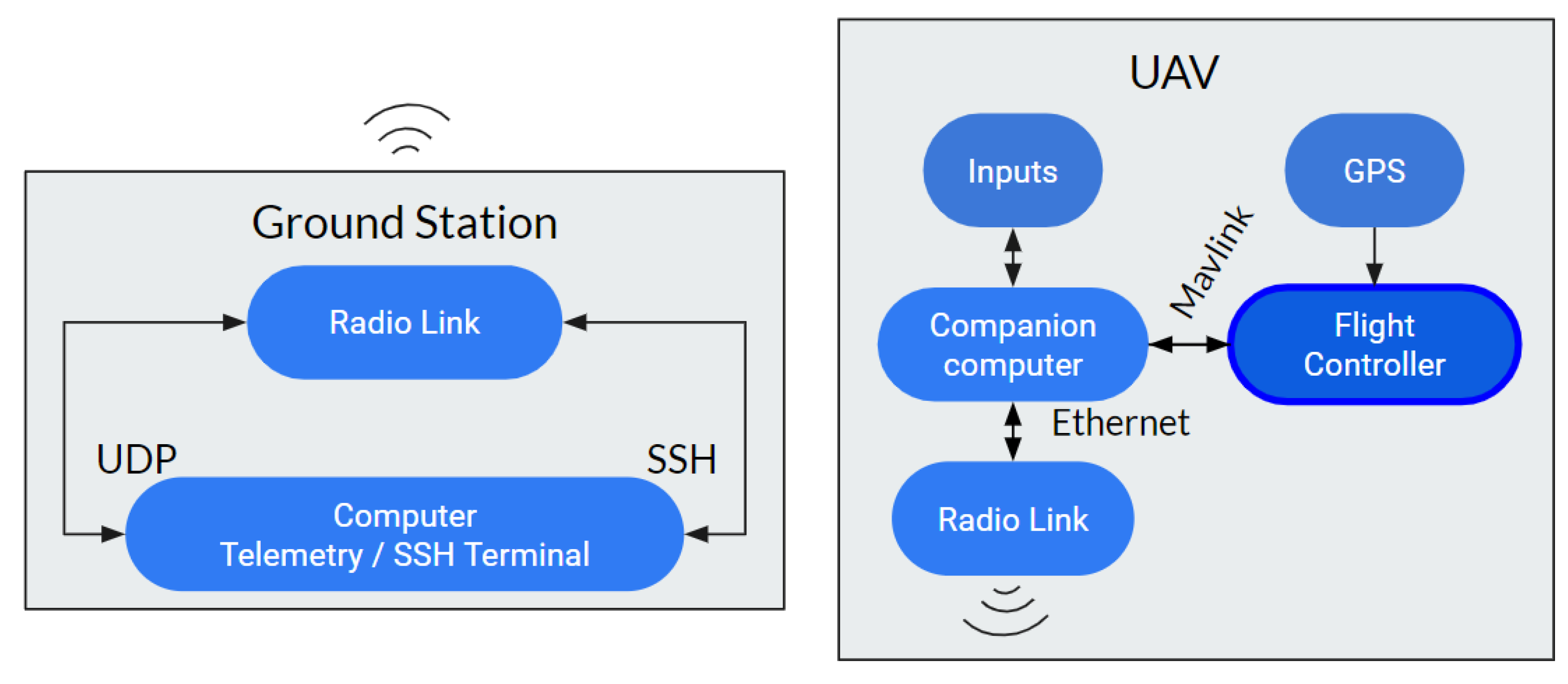
2. System Definition

Using a companion computer on board the UAV allow us to receive and send data to the flight controller. In this case the vehicle flight controller uses Ardupilot as firmware, which can communicate with a computer using Mavlink protocol. For this task we send and receive Mavlink messages, with Dronekit API for Python, over a serial port (USB-TTY) connected to the flight controller as can be seen in Figure 1. In this way we have access to all telemetry data and can command the vehicle by modifying attitude attributes as target position or velocity.
In order to maintain control with a ground station we have created an UDP port to send the telemetry data to a mission control software (Mission Planner, QGroundControl, etc.) and a SSH port to have a remote terminal with the companion computer. This ports communicate with the ground station through a radio gateway connected with both computers, UAV and ground, over Ethernet.
To test the system, we programmed an example trajectory in a constant altitude which was performed in a simulation by modifying vehicle’s velocity in real time as shown in Figure 2. The companion computer got control of the vehicle when flying and perform the maneuver until RTL mode was activated (Return To Launch position).
The system was designed in a way that allows receiving data from external sensors or the built-in sensors of the flight controller (IMU, barometer, etc.) and modify his behavior in real time so the vehicle can adapt to possible surrounding disruptions. By this way this trajectory management system opens multiple possibilities to design an UAV capable of adapting to the surrounding conditions in real time and be able to add as much sensors as needed for the application it will perform.

References

  1. Brief, L. Growth Opportunity in Global uav Market. Available online: https://www.lucintel.com/GrowthOpportunityinGlobalUAVMarket.pdf (accessed on 12 July 2019).
  2. Idries, A.; Mohamed, N.; Jawhar, I.; Mohamed, F.; Al-Jaroodi, J. Challenges of developing UAV applications: A project management view. In Proceedings of the 2015 International Conference on Industrial Engineering and Operations Management, Dubai, UAE, 3–5 March 2015; IEEE: Piscataway, NJ, USA, 2015; pp. 389–398. [Google Scholar]
Figure 1. System configuration.
Proceedings 21 00008 g001
Figure 2. Sinusoidal trajectory performed by the simulated UAV.
Proceedings 21 00008 g002
Publisher’s Note: MDPI stays neutral with regard to jurisdictional claims in published maps and institutional affiliations.

