Proceeding Paper

Causes of Ground Settlements in Upper Reservoir of Hydro-Wind Plant of El Hierro and Method Implemented for Soil Improvement †

by
Fabiola Fernández-Baniela
1,*,
Daniel Arias
2 and
Álvaro Rubio-Ordoñez
2
1
IDOM Consulting, Engineering, Architecture, S.A.U., Avda. Monasterio de El Escorial 4, 28049 Madrid, Spain
2
Department of Geology, University of Oviedo, Jesús Arias de Velasco s/n, 33005 Oviedo, Spain
*
Author to whom correspondence should be addressed.
Presented at the 2nd International Research Conference on Sustainable Energy, Engineering, Materials and Environment (IRCSEEME), Mieres, Spain, 25–27 July 2018.
Proceedings 2018, 2(23), 1468; https://doi.org/10.3390/proceedings2231468
Published: 1 November 2018

Abstract

:
This article exposes one of the main engineering problems in the design and construction of the upper reservoir of El Hierro hydro-wind plant, relative to the high settlement of the bottom in the southeast area. The high settlements measured during the construction phase are consequence of the geological-geotechnical settings of the site, a natural depression of a volcanic crater occupied by highly deformable soils derived from the weathering of volcanic materials. Ground improvement was carried out by partial preloading (mobile dune), preceded by the execution of a trial embankment in the southeast area of the reservoir, where the greatest thickness of deformable soils was identified.

1. Introduction

On El Hierro island, in order to achieve energy autonomy through fully renewable energy sources, the company Gorona del Viento El Hierro S.A. carried out a project consisting in the implementation of a new energy model, combining wind and hydraulic energy. As the successful bidder for the project, the company IDOM Consulting, Engineering, Architecture, S.A.U. carried out the detailed engineering design of El Hierro hydro-wind plant, inaugurated in 2014. Among the elements of this plant, highlights the upper water reservoir, located in the natural depression of an inactive volcanic crater, “La Caldera”, whose bottom has been waterproofed by placing a PVC geomembrane.

2. Geological Settings

El Hierro is the smallest, youngest (1.2 Ma) [1], and most isolated of the Canary Islands. These involve a chain of volcanic islands located off the north-western coast of Africa, whose origins are linked to a hot spot or plume. The formation of this island is due to the succession and stacking of two important volcanic structures (Tiñor and El Golfo), and a last stage of dorsal volcanism [2], with three axes that give the island its characteristic “Y” shape.
The location of the upper reservoir is an inactive volcanic crater, with slopes that are made up of competent and resistant volcanic rocks (“aa” lava flows). These rocks are basic to ultrabasic in composition, and based on the Mg content classified as basalts and traquibasalts. Moreover, the bottom is formed by a volcanic vent mainly filled with soils. The foot of the inner slopes of the crater is covered by colluvial deposits, derived from the action of erosion and gravity on the upper slopes of the crater (Figure 1). Beneath these recent deposits, a large thickness of soils generated by intense weathering of volcanic materials was identified. In the southeast of the reservoir, by geophysical techniques (PSC-7 to 8 and TEC-1) and rotary boreholes (S-1 to 3), 46.5 m of maximum thickness of soil was identified.

3. Geotechnical Settings

3.1. Site Investigation and Laboratory Tests

The investigations carried out in the bottom of the upper reservoir are indicated in Table 1.
12 samples of rock and paleosoil were taken in outcrops in La Caldera for their geochemical analysis. Disturbed samples taken in trial pits and undisturbed samples and core samples taken from boreholes were tested in the laboratory (Table 2).

3.2. Geotechnical Units

Based on the physical and mechanical characteristics of the soils that fill the crater, the geotechnical units indicated in Table 3 were established. Excluding colluvial soils, the observed characteristics are typical of soils derived from weathering of volcanic materials, with very high void ratios and low dry density [3,4].
The soil structure is line with the typical structure generated by weathering of volcanic materials: the younger soils (the more superficial ones), have higher density, high content of silt and sand and low clay content, while the older soils (the deeper ones) show an intense weathering, evidenced by the decrease in the content in primary minerals, and are characterized by a lower density and cementation and an increase in clay content [5].

4. Soil Improvement: Pre-Loading

Previous experiences in this type of residual volcanic soils had already been described on the island of La Palma, where significant settlements had been occurred in the Barlovento water reservoir (2.35 m estimated at the lowest point), resulting in the failure of the PVC geomembrane [6]. The high deformability of the soils filling the crater La Caldera and the limitation, imposed by the characteristics of the geomembrane, of a maximum postconstructive settlement of 10–12 cm, led to propose a soil improvement by preloading.
The selected preloading method was a “mobile dune”, which consists in moving the total volume of earth excavated in the work, to cover, in successive phases, the entire bottom of the reservoir. This would simulate the conditions of the reservoir filled with water.
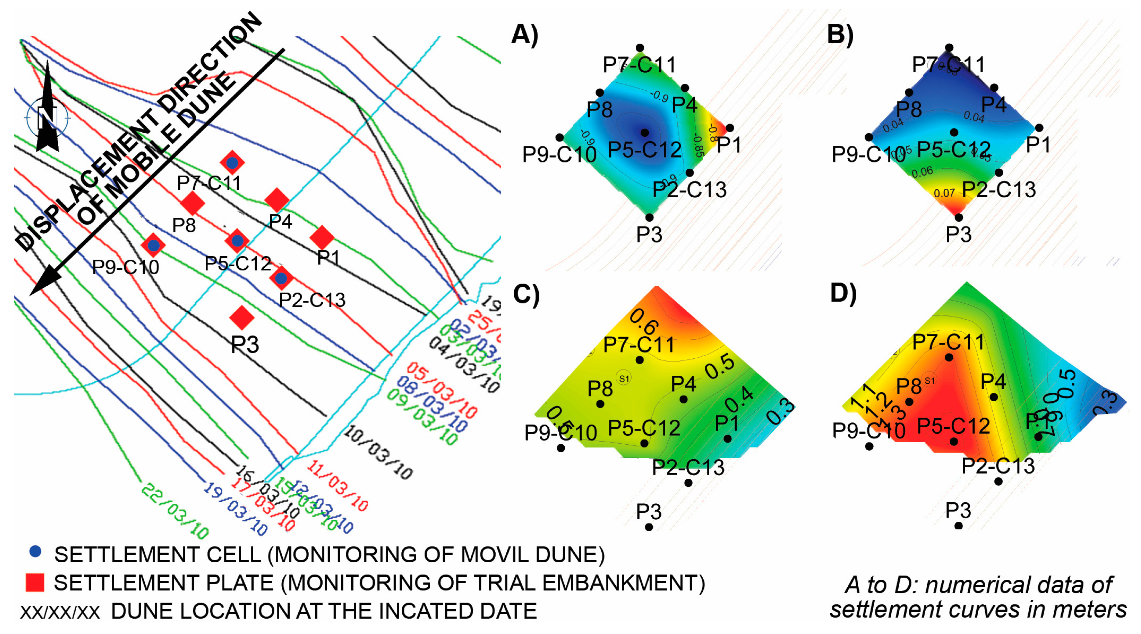
Previously to the mobile dune, in the southeast area of the deposit, a trial embankment of 10 m height was built and monitored by eight settlement plates. This provided key information regarding the behavior of these soils under the action of preloading, very useful for the design of the mobile dune execution stages (Figure 2).
The behavior of the soils was mainly of plastic type, producing a maximum settlement of 0.98 m in the center of the embankment (P-5 in Figure 2A) and a maximum rebound of the bottom when removing the embankment of 8 cm (P-3 in Figure 2B) [7].
The settlements generated by the action of the mobile dune in the southeast area of the reservoir were monitored by four settlement cells: C-10 to C-13 (Figure 2C). The settlement varied between a minimum value of 0.42 m recorded in cell C-13 (near the edge of the crater) and a maximum value of 0.68 m recorded in cell C-11 (located towards the center of the crater).
The accumulated settlement in the lousy point of the southeast area of the upper reservoir (Figure 2D), sum of those recorded during the execution of the trial embankment and the mobile dune, reached a value close to 1.5 m.

5. Conclusions

  • The soils that fill the crater “La Caldera” have been generated by the intense weathering of volcanic materials, which increases with depth.
  • The high settlements in the southeast area of the upper reservoir were due to the fact that this area may be the emission point of the crater, where greatest thickness of residual soils (up to 46.5 m) were identified. In addition, the geotechnical unit with greatest deformability, LN, has only been identified in this area of the upper reservoir.
  • The behavior of these soils during the preloading carried out for soil improvement (trial embankment and mobile dune) was mainly of plastic type, producing an accumulated settlement close to 1.5 m.

Author Contributions

D.A. contributed to the geological-geotechnical research and interpretation of results, advising IDOM in the development of the Project; Á.R.-O. carried out the geochemical study of the samples; F.F.-B. partner of IDOM, was responsible of geological-geotechnical investigation, collaborated in data analysis and wrote the paper.

Acknowledgments

The authors thank Gorona del Viento El Hierro, S.A. for the award to IDOM Consulting, Engineering, Architecture, S.A.U. of the engineering design of the hydro-wind plant project. Special thanks to IDOM staff and external advisors who have participated in the development of this project.

Conflicts of Interest

The information contained in this article is based on the results of the Geological and Geotechnical Study for the Detail Design of Hydro-wind Plant of El Hierro, carried out by the company IDOM. This project was funded by Gorona del Viento El Hierro, S.A. and financed (65%) by the Ministry of Industry, Tourism and Commerce and the IDAE.

References

  1. Guillou, H.; Carracedo, J.C.; Pérez Torrado, F.J.; Rodríguez Badiola, E. K-Ar ages and magnetic stratigraphy of a hotspot-induced, fast grown oceanic island: El Fierro, Canary Islands. J. Volcanol. Geotherm. Res. 1996, 73, 141–155. [Google Scholar] [CrossRef]
  2. Carracedo, J.C.; Rodríguez Badiola, E.; Guillou, H.J.; de la Nuez, J.; Pérez Torrado, F. Geology and volcanology of La Palma and El Hierro, Western Canaries. Estud. Geol. 2001, 57, 175–273. [Google Scholar] [CrossRef]
  3. Wesley, L.D. Consolidation behavior of allophane clays. Géotechnique 2001, 51, 901–904. [Google Scholar] [CrossRef]
  4. Shoji, S.; Nanzyo, M.; Dahlgren, R.A. Volcanic Ash Soils: Genesis, Properties and Utilization; Elsevier Science: Amsterdam, The Netherlands, 1993. [Google Scholar]
  5. Lizcano, A.; Herrera, M.C.; Santamarina, J.C. Suelos derivados de cenizas volcánicas en Colombia. Rev. Int. Desastres Nat. Accid. Infraestruct. Civ. 2006, 6, 167–197. [Google Scholar]
  6. Estaire, J.; Díez, J.A.; Martínez, J.M. Análisis de las causas de los asentamientos producidos en la balsa de Barlovento (Isla de La Palma, Canarias). In Proceedings of the 2º Congreso International Sobre Proyecto, Construcción e Impermeabilización de Balsas, Palma de Mallorca, España, 23–25 April 2008. [Google Scholar]
  7. Martín-Gómez, M.R.; Fernández Baniela, F.; Arribas-Pérez de Obanos, J.J. Deformational behaviour of pyroclastic rocks beneath the upper reservoir of the hydro-wind plant at El Hierro. In Proceedings of the 3rd International Workshop on Rock Mechanical and Geo-Engineering in Volcanic Enviroments, Tenerife, Spain, 31 May–3 June 2010. [Google Scholar]
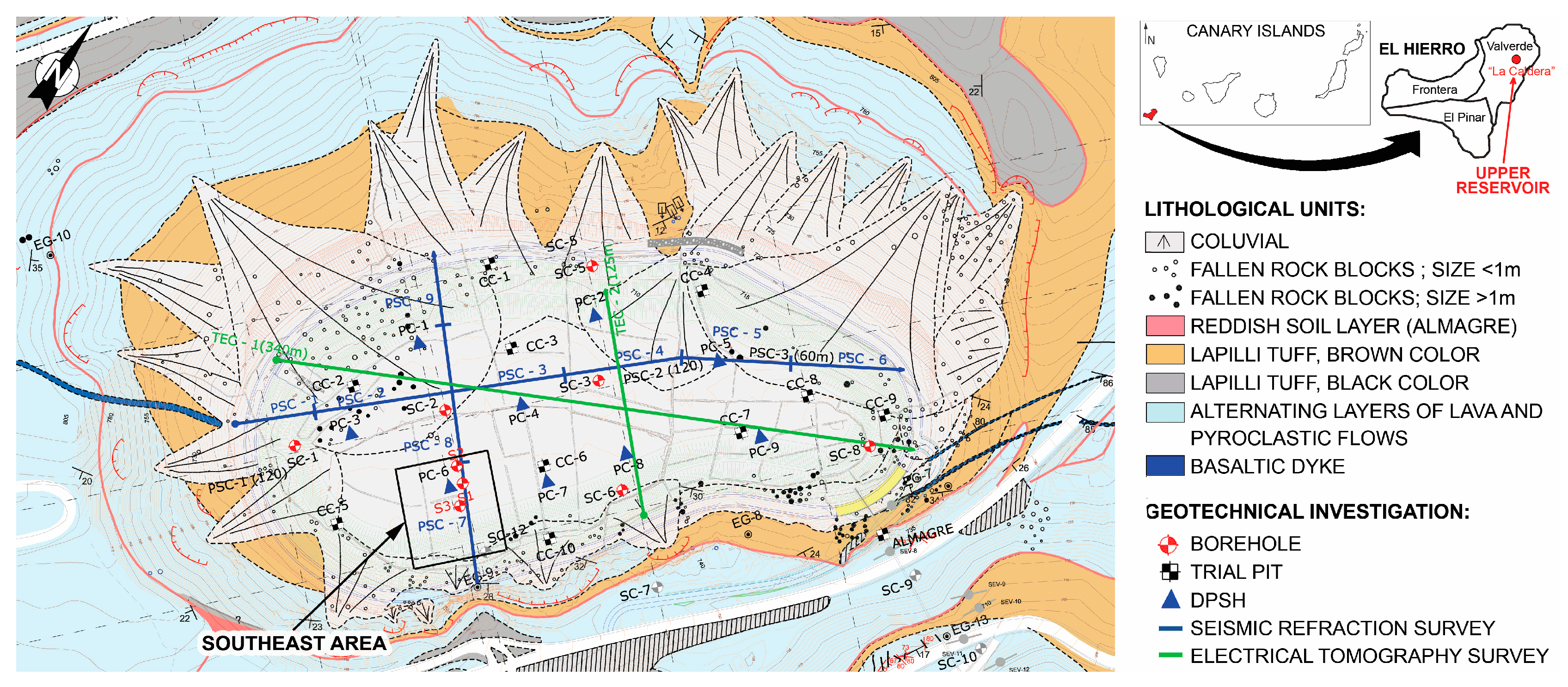
Figure 1. Geological mapping of “La Caldera” place, with the location of site investigations.
Proceedings 02 01468 g001
Figure 2. Maps of settlement distribution in the southeast area of the upper reservoir: (A) loading and stabilization stages of the trial embankment; (B) unloading stage of the trial embankment (rebound); (C) loading stage of the mobile dune; (D) accumulated settlement. (Mapping software: SURFER).
Proceedings 02 01468 g002
Table 1. Mechanical investigations and in situ tests.
SC/SSPTPRLGLFPCCCPSCTEC
Units1096251991192
Lenght (m)346.35 127.9 540465
SC/S: rotary boreholes with continuous core recovering; SPT: standard penetration test; PR: pressuremeter test (Elastmeter-2, Model-4181, from Oyo Corporation, Tokyo, Japan); LG: Lugeon permeability test; LF: Lefranc permeability test; PC: dynamic penetration (DPSH); CC: trial pit; PSC: seismic refraction profile; TEC: electrical tomography profile.
Table 2. Laboratory tests.
DDWDGRIPUCSTCSLOGMXRDMPCBRDS
Units378595915128127633
DD/WD: dry/wet density; GR: granulometric size analysis; IP: Atterberg limits; UCS/TCS: unconfined/triaxial compressive strength; L: Lambe; O: oedometer; GM: geochemical analysis (X-ray fluorescence); XRD: mineralogical analysis (X-ray diffraction); MP: modified Proctor; CBR: California bearing ratio; DS: direct shear.
Table 3. Geotechnical units filling the crater and geotechnical parameters.
Bottom
Depth
Unit Description
(USCS)
SPTF
(%)
LL
(%)
IP
(%)
DD
(g/cm3)
C
(kPa)
Φ
(°)
Ep (MPa)eoEm
(MPa)
(m)FLRL
5–6Qc: coluvial (SP-GP)5–9153881.45 *0283.5
25–30Lm: brown silt (MH-ML)10–22515181.290–343813500.9925
34–39LN: black silt (MH)0–13835770.934399232.2714
39–46.5La: sandy silt (ML)7–35393641.24 10491.4419
USCS: Unified Soil Classification System; SPT: N30 from standard penetration test; F: fines content (<0.074 mm); LL: liquid limit; IP: plasticity index; DD: dry density; C: cohesion; Φ: friction angle; Ep: pressuremeter modulus obtained from first load (FL) and reload (RL); eo: void ratio; Em: oedometric modulus. * Calculated from wet density and water content.
Publisher’s Note: MDPI stays neutral with regard to jurisdictional claims in published maps and institutional affiliations.