Thematic Fragmentation and Convergence in Urban Flood Simulation Research: A 45-Year Bibliometric Mapping
Abstract
1. Introduction
- To map the thematic evolution of urban flood research, especially in relation to climate adaptation, risk, and resilience;
- To identify dominant thematic clusters and assess the extent of disciplinary integration or fragmentation;
- To analyze the conceptual positioning of simulation, risk, and infrastructure planning, and evaluate their role in connecting research with planning practice.
- RQ1: How has the thematic landscape of urban flood research evolved over time, particularly in relation to climate, risk, and resilience?;
- RQ2: What are the dominant thematic structures in urban flood literature, and how do they reflect disciplinary integration or fragmentation?;
- RQ3: How are simulation, risk, and infrastructure planning positioned within the field’s conceptual structure, and what does this suggest about theory–practice integration?
2. Materials and Methods
2.1. Data Sources
2.2. Query Strategy
- Urban flooding as the hazard context;
- Simulation and modeling as methodological approaches;
- Planning, infrastructure, or risk as governance and action-oriented domains.
- TITLE-ABS-KEY (“urban flood*” OR “urban flooding”) AND
- TITLE-ABS-KEY (“simulation” OR “forecasting” OR “modeling”) AND
- TITLE-ABS-KEY (“planning” OR “resilience” OR “infrastructure” OR “risk”)
(TITLE-ABS-KEY (“urban flood*” OR “urban flooding”) AND TITLE-ABS-KEY (“simulation” OR “forecasting” OR “modeling”) AND TITLE-ABS-KEY (“planning” OR “resilience” OR “infrastructure” OR “risk”)) AND (LIMIT-TO (LANGUAGE, “English”)) AND (LIMIT-TO (DOCTYPE, “ar”) OR LIMIT-TO (DOCTYPE, “cp”)) AND (LIMIT-TO (SUBJAREA, “ENVI”) OR LIMIT-TO (SUBJAREA, “ENGI”) OR LIMIT-TO (SUBJAREA, “SOCI”) OR LIMIT-TO (SUBJAREA, “EART”) OR LIMIT-TO (SUBJAREA, “COMP”) OR LIMIT-TO (SUBJAREA, “AGRI”) OR LIMIT-TO (SUBJAREA, “DECI”) OR LIMIT-TO (SUBJAREA, “MULT”) OR LIMIT-TO (SUBJAREA, “ECON”))
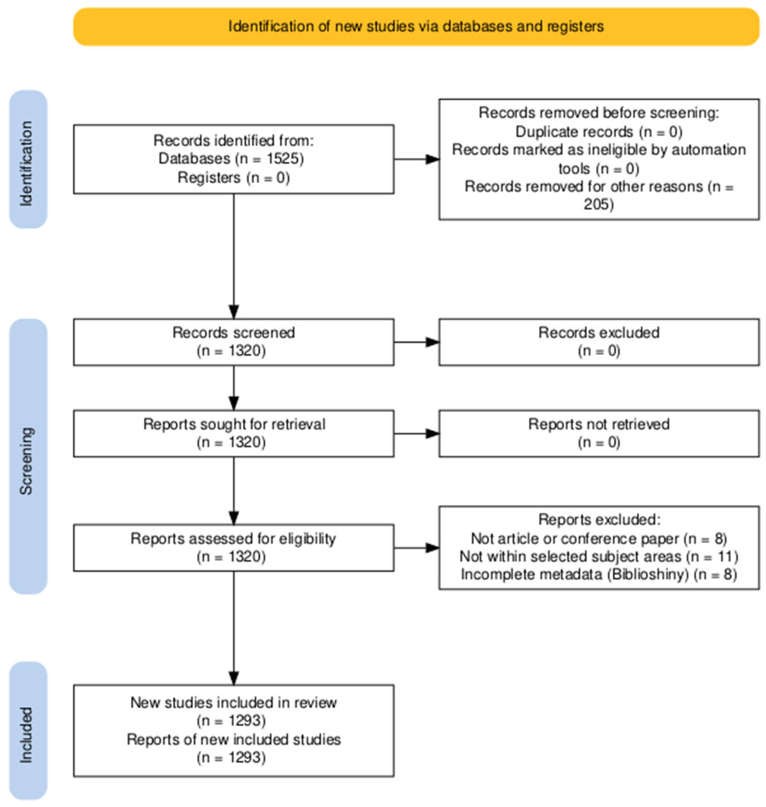
| Step | Filter Description | Remaining Documents |
|---|---|---|
| 1 | Initial Boolean query | 1525 |
| 2 | Filter: English language only | 1320 |
| 3 | Filter: Article or conference paper (document type) | 1320 |
| 4 | Filter: Subject areas relevant to environmental science, engineering, social science, earth science, computer science, agriculture, decision science, multidisciplinary, and economics | 1307 |
| 5 | Filter: biblioshiny metadata completeness (title, abstract, keywords, and references) | 1293 |
2.3. Analysis Process
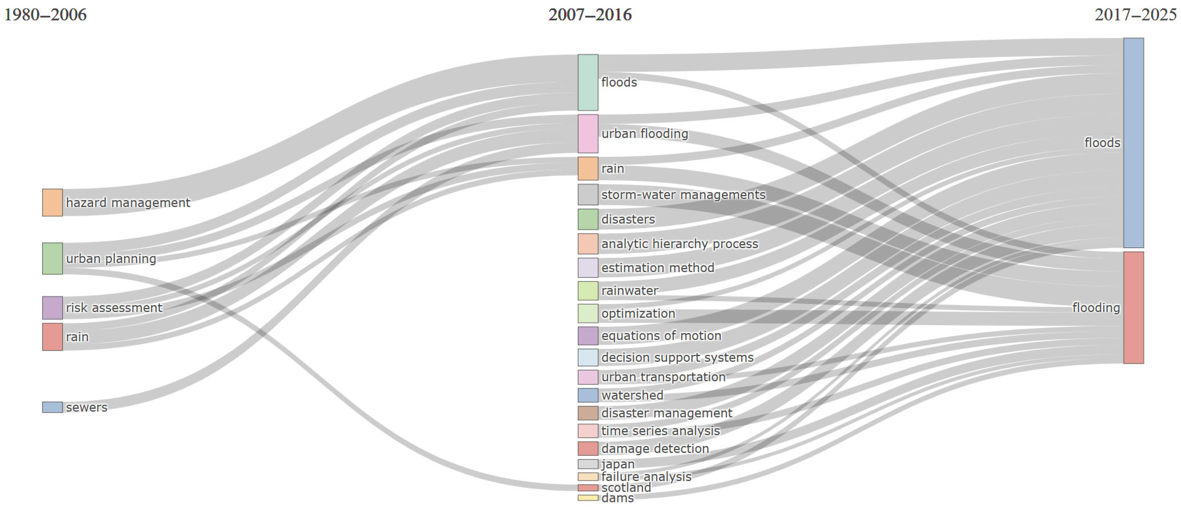
- Thematic evolution mapping (Sankey plots) to trace longitudinal changes in dominant keywords across three temporal segments.
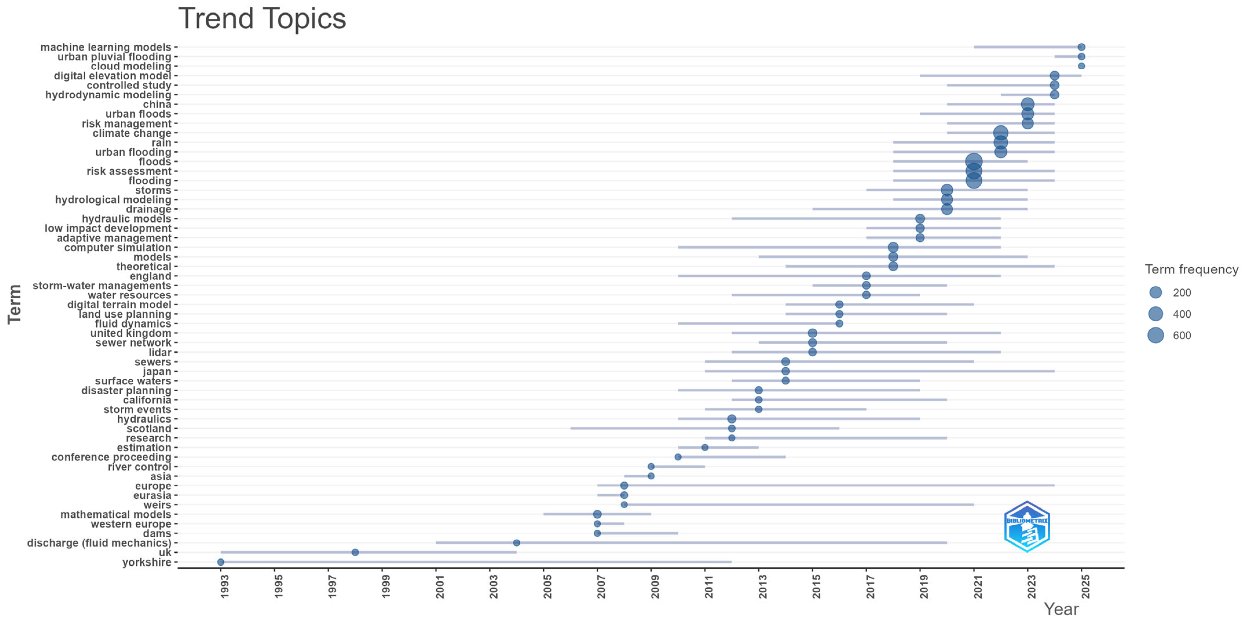
- Trend topic analysis to visualize the chronological emergence and decline of high-frequency terms.
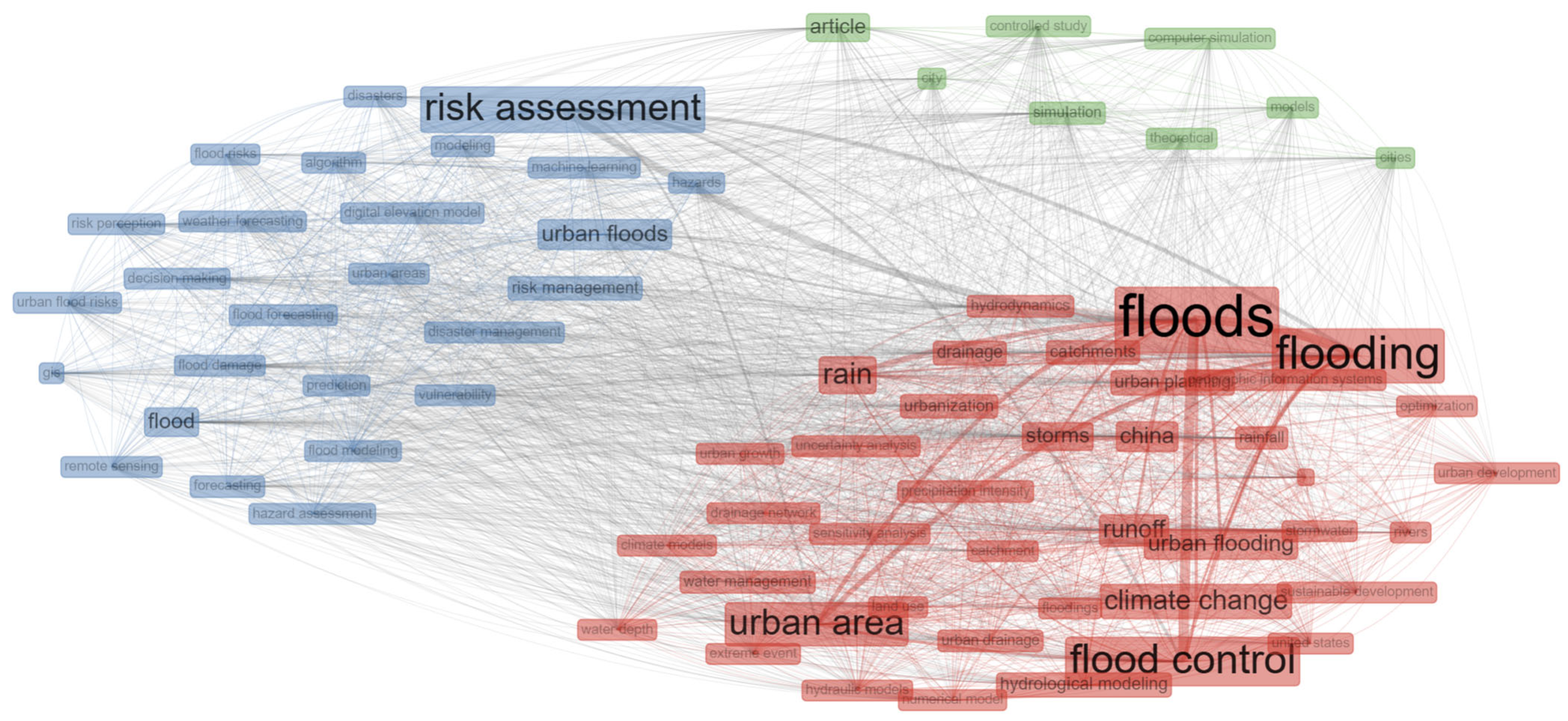
- Keyword co-occurrence networks to observe thematic clustering and transitions in terminology.
- Co-word network analysis to identify major keyword clusters and their semantic linkages.
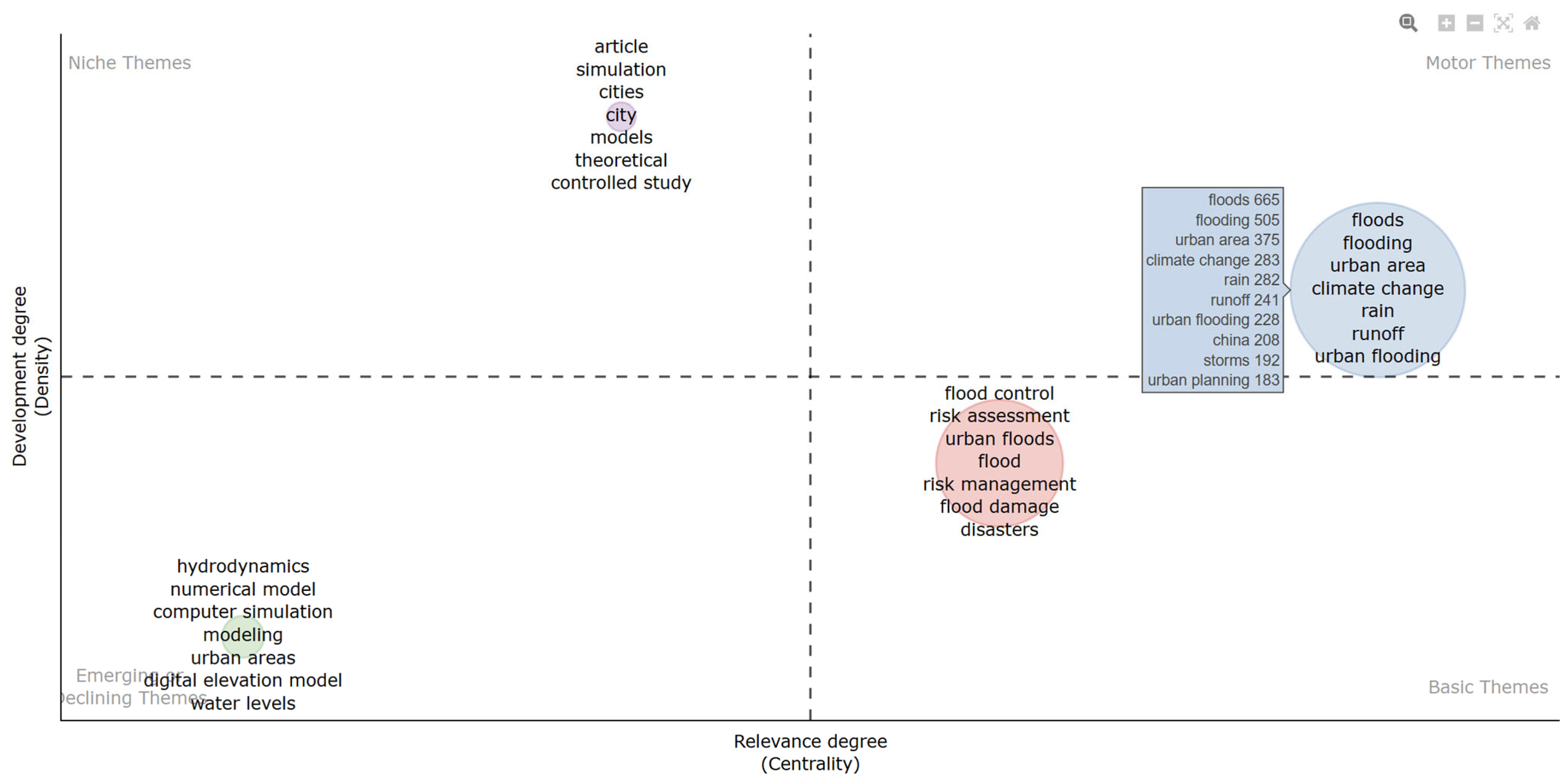
- Thematic quadrant mapping (centrality vs. density plots) to classify topics as motor, niche, basic, or emerging themes based on their structural properties.
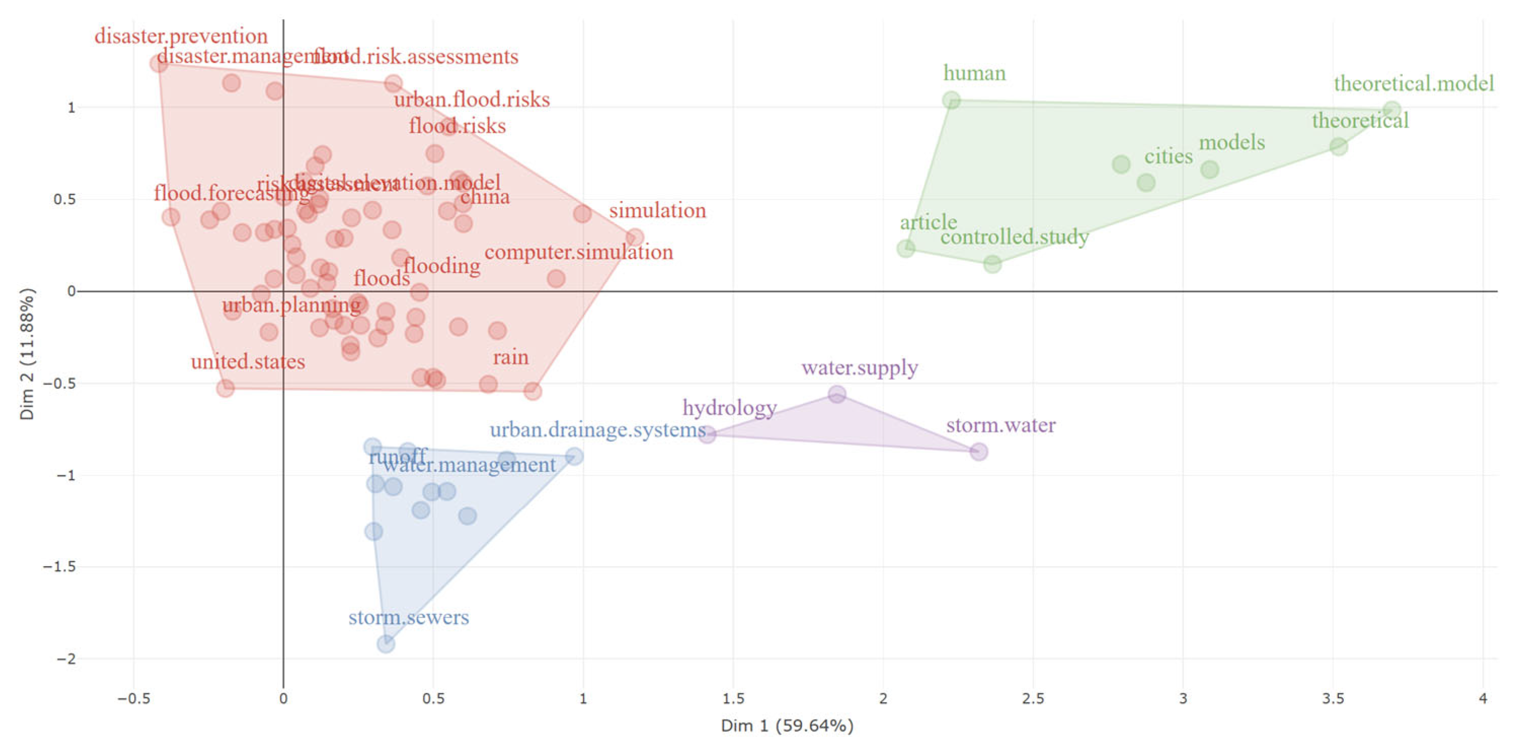
- Multiple Correspondence Analysis (MCA) to generate a factorial map, positioning core concepts spatially based on their co-occurrence profiles.
3. Results
3.1. Overview
3.2. Thematic Evolution of Urban Flood Research
3.3. Structural Patterns and Disciplinary Intersections
3.4. Conceptual Positioning of Simulation, Risk, and Planning
4. Discussion
5. Limitations and Future Research Opportunities
6. Conclusions
Author Contributions
Funding
Data Availability Statement
Acknowledgments
Conflicts of Interest
Abbreviations
| RQ | Research questions |
| PRISMA | Preferred Reporting Items for Systematic Reviews and Meta-Analyses |
| MCA | Multiple Correspondence Analysis |
References
- Tingsanchali, T. Urban Flood Disaster Management. Procedia Eng. 2012, 32, 25–37. [Google Scholar] [CrossRef]
- Ferguson, S.; van Ledden, M.; Rubinyi, S.; Garcia, A.C.; Doeffinger, T. Urban Flood Risk Handbook: Assessing Risk and Identifying Interventions (English). World Bank Group. 2023. Available online: http://documents.worldbank.org/curated/en/099080123151036528 (accessed on 7 January 2025).
- National Disaster Reduction Center of China and UNDP China. Research Report of Urban Flood Risk Management Capacity. 2017. Available online: https://www.undp.org/china/publications/research-report-urban-flood-risk-management-capcity (accessed on 7 January 2025).
- Zhou, Q.; Leng, G.; Su, J.; Ren, Y. Comparison of Urbanization and Climate Change Impacts on Urban Flood Volumes: Importance of Urban Planning and Drainage Adaptation. Sci. Total Environ. 2019, 658, 24–33. [Google Scholar] [CrossRef] [PubMed]
- Li, C.; Sun, N.; Lu, Y.; Guo, B.; Wang, Y.; Sun, X.; Yao, Y. Review on Urban Flood Risk Assessment. Sustainability 2023, 15, 765. [Google Scholar] [CrossRef]
- Mohammad, K.; Ana, H.; Sara, N. Improvement of Urban Drainage System Performance under Climate Change Impact: Case Study. J. Hydrol. Eng. 2011, 16, 395–412. [Google Scholar] [CrossRef]
- Rentschler, J.; Avner, P.; Marconcini, M.; Su, R.; Strano, E.; Vousdoukas, M.; Hallegatte, S. Global Evidence of Rapid Urban Growth in Flood Zones since 1985. Nature 2023, 622, 87–92. [Google Scholar] [CrossRef] [PubMed]
- Huong, H.T.L.; Pathirana, A. Urbanization and Climate Change Impacts on Future Urban Flooding in Can Tho City, Vietnam. Hydrol. Earth Syst. Sci. 2013, 17, 379–394. [Google Scholar] [CrossRef]
- Fu, X.; Xue, F.; Liu, Y.; Chen, F.; Yang, H. Evaluation of Urban Flood Susceptibility Under the Influence of Urbanization Based on Shared Socioeconomic Pathways. Land 2025, 14, 621. [Google Scholar] [CrossRef]
- Pradana, M.R.; Dimyati, M. Tracking Urban Sprawl: A Systematic Review and Bibliometric Analysis of Spatio-Temporal Patterns Using Remote Sensing and GIS. Eur. J. Geogr. 2024, 15, 190–203. [Google Scholar] [CrossRef]
- Cao, F.; Xu, X.; Zhang, C.; Kong, W. Evaluation of Urban Flood Resilience and Its Space-Time Evolution: A Case Study of Zhejiang Province, China. Ecol. Indic. 2023, 154, 110643. [Google Scholar] [CrossRef]
- Agonafir, C.; Lakhankar, T.; Khanbilvardi, R.; Krakauer, N.; Radell, D.; Devineni, N. A Review of Recent Advances in Urban Flood Research. Water Secur. 2023, 19, 100141. [Google Scholar] [CrossRef]
- Pregnolato, M.; Ford, A.; Robson, C.; Glenis, V.; Barr, S.; Dawson, R. Assessing Urban Strategies for Reducing the Impacts of Extreme Weather on Infrastructure Networks. R. Soc. Open Sci. 2016, 3, 160023. [Google Scholar] [CrossRef] [PubMed]
- Xie, J.; Chen, H.; Liao, Z.; Gu, X.; Zhu, D.; Zhang, J. An Integrated Assessment of Urban Flooding Mitigation Strategies for Robust Decision Making. Environ. Model. Softw. 2017, 95, 143–155. [Google Scholar] [CrossRef]
- Qin, H.P.; Li, Z.X.; Fu, G. The Effects of Low Impact Development on Urban Flooding under Different Rainfall Characteristics. J. Environ. Manag. 2013, 129, 577–585. [Google Scholar] [CrossRef] [PubMed]
- Chen, J.; Hill, A.A.; Urbano, L.D. A GIS-Based Model for Urban Flood Inundation. J. Hydrol. 2009, 373, 184–192. [Google Scholar] [CrossRef]
- Fewtrell, T.J.; Duncan, A.; Sampson, C.C.; Neal, J.C.; Bates, P.D. Benchmarking Urban Flood Models of Varying Complexity and Scale Using High Resolution Terrestrial LiDAR Data. Phys. Chem. Earth 2011, 36, 281–291. [Google Scholar] [CrossRef]
- Rafiei-Sardooi, E.; Azareh, A.; Choubin, B.; Mosavi, A.H.; Clague, J.J. Evaluating Urban Flood Risk Using Hybrid Method of TOPSIS and Machine Learning. Int. J. Disaster Risk Reduct. 2021, 66, 102614. [Google Scholar] [CrossRef]
- Zhang, Y.; Wang, L.; Zhang, Q.; Li, Y.; Wang, P.; Hu, T. A Comprehensive Analysis of Urban Flooding Under Different Rainfall Patterns: A Full-Process Perspective in Haining, China. Atmosphere 2025, 16, 305. [Google Scholar] [CrossRef]
- Avashia, V.; Garg, A. Implications of Land Use Transitions and Climate Change on Local Flooding in Urban Areas: An Assessment of 42 Indian Cities. Land Use Policy 2020, 95, 104571. [Google Scholar] [CrossRef]
- Schmitt, T.G.; Thomas, M.; Ettrich, N. Analysis and Modeling of Flooding in Urban Drainage Systems. J. Hydrol. 2004, 299, 300–311. [Google Scholar] [CrossRef]
- Chen, A.S.; Evans, B.; Djordjević, S.; Savić, D.A. A Coarse-Grid Approach to Representing Building Blockage Effects in 2D Urban Flood Modelling. J. Hydrol. 2012, 426–427, 1–16. [Google Scholar] [CrossRef]
- Smith, L.; Liang, Q.; James, P.; Lin, W. Assessing the Utility of Social Media as a Data Source for Flood Risk Management Using a Real-Time Modelling Framework. J. Flood Risk Manag. 2017, 10, 370–380. [Google Scholar] [CrossRef]
- Henonin, J.; Russo, B.; Mark, O.; Gourbesville, P. Real-Time Urban Flood Forecasting and Modelling—A State of the Art. J. Hydroinformatics 2013, 15, 717–736. [Google Scholar] [CrossRef]
- Jamali, B.; Löwe, R.; Bach, P.M.; Urich, C.; Arnbjerg-Nielsen, K.; Deletic, A. A Rapid Urban Flood Inundation and Damage Assessment Model. J. Hydrol. 2018, 564, 1085–1098. [Google Scholar] [CrossRef]
- Soares-Frazão, S.; Lhomme, J.; Guinot, V.; Zech, Y. Two-Dimensional Shallow-Water Model with Porosity for Urban Flood Modelling. J. Hydraul. Res. 2008, 46, 45–64. [Google Scholar] [CrossRef]
- Schubert, J.E.; Sanders, B.F. Building Treatments for Urban Flood Inundation Models and Implications for Predictive Skill and Modeling Efficiency. Adv. Water Resour. 2012, 41, 49–64. [Google Scholar] [CrossRef]
- Mustafa, A.; Bruwier, M.; Archambeau, P.; Erpicum, S.; Pirotton, M.; Dewals, B.; Teller, J. Effects of Spatial Planning on Future Flood Risks in Urban Environments. J. Environ. Manag. 2018, 225, 193–204. [Google Scholar] [CrossRef] [PubMed]
- Huang, H.; Chen, X.; Zhu, Z.; Xie, Y.; Liu, L.; Wang, X.; Wang, X.; Liu, K. The Changing Pattern of Urban Flooding in Guangzhou, China. Sci. Total Environ. 2018, 622–623, 394–401. [Google Scholar] [CrossRef] [PubMed]
- Ma, S.; Zhou, T.; Stone, D.A.; Polson, D.; Dai, A.; Stott, P.A.; von Storch, H.; Qian, Y.; Burke, C.; Wu, P.; et al. Detectable Anthropogenic Shift toward Heavy Precipitation over Eastern China. J. Clim. 2017, 30, 1381–1396. [Google Scholar] [CrossRef]
- Radu, G.; Chevereșan, M.I.; Perju, S.; Bărbulescu, A. Integrating Nature-Based Solutions for Increased Resilience to Urban Flooding in the Climate Change Context. Hydrology 2025, 12, 16. [Google Scholar] [CrossRef]
- Price, R.K.; Vojinovic, Z. Urban Food Disaster Management. Urban Water J. 2008, 5, 259–276. [Google Scholar] [CrossRef]
- Miguez, M.G.; Rezende, O.M.; Veról, A.P. City Growth and Urban Drainage Alternatives: Sustainability Challenge. J. Urban Plan. Dev. 2015, 141, 3. [Google Scholar] [CrossRef]
- Dong, B.; Xia, J.; Li, Q.; Zhou, M. Risk Assessment for People and Vehicles in an Extreme Urban Flood: Case Study of the “7.20” Flood Event in Zhengzhou, China. Int. J. Disaster Risk Reduct. 2022, 80, 103205. [Google Scholar] [CrossRef]
- Gul, E. Urban Flood Hazard Assessment Using FLA-Optimized Boost Algorithms in Ankara, Türkiye. Appl. Water Sci. 2025, 15, 78. [Google Scholar] [CrossRef]
- Hu, Y.; Tang, M.; Ma, S.; Zhu, Z.; Zhou, Q.; Xie, Q.; Wu, Y. A Rapid Prediction Method for Key Information of the Urban Flood Control Engineering System Based on Machine Learning: An Empirical Study of the Wusha River Basin. Water 2025, 17, 784. [Google Scholar] [CrossRef]
- Bellos, V.; Tsakiris, G. Comparing Various Methods of Building Representation for 2D Flood Modelling In Built-Up Areas. Water Resour. Manag. 2015, 29, 379–397. [Google Scholar] [CrossRef]
- Li, C.; Cheng, X.; Li, N.; Du, X.; Yu, Q.; Kan, G. A Framework for Flood Risk Analysis and Benefit Assessment of Flood Control Measures in Urban Areas. Int. J. Environ. Res. Public Health 2016, 13, 787. [Google Scholar] [CrossRef] [PubMed]
- Picó-Gutiérrez, V.; González-Ramírez, F.E.; Escudero-Gómez, L.A. From Segregation to Fragmentation: Mapping the Recent Global Literature. Urban Sci. 2025, 9, 98. [Google Scholar] [CrossRef]
- Karger, E.; Rothweiler, A.; Brée, T.; Ahlemann, F. Building the Smart City of Tomorrow: A Bibliometric Analysis of Artificial Intelligence in Urbanization. Urban Sci. 2025, 9, 132. [Google Scholar] [CrossRef]
- Aria, M.; Cuccurullo, C. Bibliometrix: An R-Tool for Comprehensive Science Mapping Analysis. J. Informetr. 2017, 11, 959–975. [Google Scholar] [CrossRef]
- Page, M.J.; Moher, D.; Bossuyt, P.M.; Boutron, I.; Hoffmann, T.C.; Mulrow, C.D.; Shamseer, L.; Tetzlaff, J.M.; Akl, E.A.; Brennan, S.E.; et al. PRISMA 2020 Explanation and Elaboration: Updated Guidance and Exemplars for Reporting Systematic Reviews. BMJ 2021, 372, n160. [Google Scholar] [CrossRef] [PubMed]
- Page, M.J.; McKenzie, J.E.; Bossuyt, P.M.; Boutron, I.; Hoffmann, T.C.; Mulrow, C.D.; Shamseer, L.; Tetzlaff, J.M.; Akl, E.A.; Brennan, S.E.; et al. The PRISMA 2020 Statement: An Updated Guideline for Reporting Systematic Reviews. BMJ 2021, 372, 71. [Google Scholar] [CrossRef] [PubMed]
- Lari, S.; Frattini, P.; Crosta, G.B. Local Scale Multiple Quantitative Risk Assessment and Uncertainty Evaluation in a Densely Urbanised Area (Brescia, Italy). Nat. Hazards Earth Syst. Sci. 2012, 12, 3387–3406. [Google Scholar] [CrossRef]
- Talib, A.; Randhir, T.O. Long-Term Effects of Land-Use Change on Water Resources in Urbanizing Watersheds. PLoS Water 2023, 2, e0000083. [Google Scholar] [CrossRef]
- Xu, H.; Gao, J.; Yu, X.; Qin, Q.; Du, S.; Wen, J. Assessment of Rainstorm Waterlogging Disaster Risk in Rapidly Urbanizing Areas Based on Land Use Scenario Simulation: A Case Study of Jiangqiao Town in Shanghai, China. Land 2024, 13, 1088. [Google Scholar] [CrossRef]
- Qin, X.-L.; Wang, S.-F.; Meng, M. Flood Cascading on Critical Infrastructure with Climate Change: A Spatial Analysis of the Extreme Weather Event in Xinxiang, China. Adv. Clim. Change Res. 2023, 14, 458–468. [Google Scholar] [CrossRef]
- Hettiarachchi, S.; Wasko, C.; Sharma, A. Can Antecedent Moisture Conditions Modulate the Increase in Flood Risk Due to Climate Change in Urban Catchments? J. Hydrol. 2019, 571, 11–20. [Google Scholar] [CrossRef]
- Suttles, K.M.; Singh, N.K.; Vose, J.M.; Martin, K.L.; Emanuel, R.E.; Coulston, J.W.; Saia, S.M.; Crump, M.T. Assessment of Hydrologic Vulnerability to Urbanization and Climate Change in a Rapidly Changing Watershed in the Southeast U.S. Sci. Total Environ. 2018, 645, 806–816. [Google Scholar] [CrossRef] [PubMed]
- Iradukunda, P.; Mwanaumo, E.M.; Kabika, J. Modelling the Future Climate Impacts on Hydraulic Infrastructure Development in Tropical (Peri-)Urban Region: Case of Kigali, Rwanda. Heliyon 2024, 10, e27126. [Google Scholar] [CrossRef] [PubMed]
- Addo, K.A.; Larbi, L.; Amisigo, B.; Ofori-Danson, P.K. Impacts of Coastal Inundation Due to Climate Change in a CLUSTER of Urban Coastal Communities in Ghana, West Africa. Remote Sens. 2011, 3, 2029–2050. [Google Scholar] [CrossRef]
- Martyn, N.Q.J.; Karney, B.W.; Posen, I.D. Whole Value at Risk for Flood Damage Estimates through Spatial Data Analysis. Environ. Res. Infrastruct. Sustain. 2024, 4, 015011. [Google Scholar] [CrossRef]
- Xu, Z.; Xia, J.; Li, Q.; Feng, J.; Dong, B. A Formula for Quantifying the Overflow Discharge Capacity of Street Inlet in a Surcharged Urban Drainage System. J. Hydrol. 2025, 660, 133386. [Google Scholar] [CrossRef]
- Brown, I.W.; McDougall, K.; Alam, M.d.J.; Chowdhury, R.; Chadalavada, S. Calibration of a Continuous Hydrologic Simulation Model in the Urban Gowrie Creek Catchment in Toowoomba, Australia. J. Hydrol. Reg. Stud. 2022, 40, 101021. [Google Scholar] [CrossRef]
- Ahilan, S.; Guan, M.; Wright, N.; Sleigh, A.; Allen, D.; Arthur, S.; Haynes, H.; Krivtsov, V. Modelling the Long-Term Suspended Sedimentological Effects on Stormwater Pond Performance in an Urban Catchment. J. Hydrol. 2019, 571, 805–818. [Google Scholar] [CrossRef]
- Xing, Y.; Shao, D.; Liang, Q.; Chen, H.; Ma, X.; Ullah, I. Investigation of the Drainage Loss Effects with a Street View Based Drainage Calculation Method in Hydrodynamic Modelling of Pluvial Floods in Urbanized Area. J. Hydrol. 2022, 605, 127365. [Google Scholar] [CrossRef]
- Yang, Y.; Pan, C.; Fan, G.; Tian, M.; Wang, J. A New Urban Waterlogging Simulation Method Based on Multi-Factor Correlation. Water 2022, 14, 1421. [Google Scholar] [CrossRef]
- Chen, J.; Li, Y.; Zhang, S. Fast Prediction of Urban Flooding Water Depth Based on CNN−LSTM. Water 2023, 15, 1397. [Google Scholar] [CrossRef]
- Coulibaly, G.; Leye, B.; Tazen, F.; Mounirou, L.A.; Karambiri, H. Urban Flood Modeling Using 2D Shallow-Water Equations in Ouagadougou, Burkina Faso. Water 2020, 12, 2120. [Google Scholar] [CrossRef]
- Zhang, Y.; Li, X.; Kong, N.; Zhou, M.; Zhou, X. Spatial Accessibility Assessment of Emergency Response of Urban Public Services in the Context of Pluvial Flooding Scenarios: The Case of Jiaozuo Urban Area, China. Sustainability 2022, 14, 6332. [Google Scholar] [CrossRef]
- Jang, W.S.; Kim, J.; Engel, B.A.; Kang, S.W.; Park, Y.; Yoon, H.; Lim, K.J.; Jung, Y.; Shin, Y. Development of a Prototype Web GIS-Based Disaster Management System for Safe Operation of the next Generation Bimodal Tram, South Korea-Focused Flooding and Snowfall. Sustainability 2014, 6, 1776–1795. [Google Scholar] [CrossRef]
- Grežo, H.; Močko, M.; Izsóff, M.; Vrbičanová, G.; Petrovič, F.; Strańák, J.; Muchová, Z.; Slámová, M.; Olah, B.; Machar, I. Flood Risk Assessment for the Long-Term Strategic Planning Considering the Placement of Industrial Parks in Slovakia. Sustainability 2020, 12, 4144. [Google Scholar] [CrossRef]
- Mora-Melià, D.; López-Aburto, C.S.; Ballesteros-Pérez, P.; Muñoz-Velasco, P. Viability of Green Roofs as a Flood Mitigation Element in the Central Region of Chile. Sustainability 2018, 10, 1130. [Google Scholar] [CrossRef]
- Shan, X.; Yin, J.; Wang, J. Risk Assessment of Shanghai Extreme Flooding under the Land Use Change Scenario. Nat. Hazards 2022, 110, 1039–1060. [Google Scholar] [CrossRef]
- Jodar-Abellan, A.; Valdes-Abellan, J.; Pla, C.; Gomariz-Castillo, F. Impact of Land Use Changes on Flash Flood Prediction Using a Sub-Daily SWAT Model in Five Mediterranean Ungauged Watersheds (SE Spain). Sci. Total Environ. 2019, 657, 1578–1591. [Google Scholar] [CrossRef] [PubMed]
- Barbosa, S.A.; Wang, Y.; Goodall, J.L. Exploring Infiltration Effects on Coastal Urban Flooding: Insights from Nuisance to Extreme Events Using 2D/1D Hydrodynamic Modeling and Crowdsourced Flood Reports. Sci. Total Environ. 2025, 968, 178908. [Google Scholar] [CrossRef] [PubMed]
- Bryant, S.P.; Davies, E.G.R.; Sol, D.; Davis, S. The Progression of Flood Risk in Southern Alberta since the 2013 Flood. J. Flood Risk Manag. 2022, 15, e12811. [Google Scholar] [CrossRef]
- Wang, H.; Lei, X.; Wang, C.; Liao, W.; Kang, A.; Huang, H.; Ding, X.; Chen, Y.; Zhang, X. A Coordinated Drainage and Regulation Model of Urban Water Systems in China: A Case Study in Fuzhou City. River 2023, 2, 5–20. [Google Scholar] [CrossRef]
- Liu, Y.; Zhang, H.; Chen, H.; Chen, C. Flood Impact on Urban Roads and Commuting: A Case Study of Wuhan, China. Front. Environ. Sci. 2022, 10, 1056854. [Google Scholar] [CrossRef]
- Han, H.; Hou, J.; Xu, Z.; Jing, H.; Gong, J.; Zuo, D.; Li, B.; Yang, S.; Kang, Y.; Wang, R. A GPU-Accelerated Hydrodynamic Model for Urban Rainstorm Inundation Simulation: A Case Study in China. KSCE J. Civ. Eng. 2022, 26, 1494–1504. [Google Scholar] [CrossRef]
- Assaf, G.; Assaad, R.H. Optimal Preventive Maintenance, Repair, and Replacement Program for Catch Basins to Reduce Urban Flooding: Integrating Agent-Based Modeling and Monte Carlo Simulation. Sustainability 2023, 15, 8527. [Google Scholar] [CrossRef]
- Dong, S.; Esmalian, A.; Farahmand, H.; Mostafavi, A. An Integrated Physical-Social Analysis of Disrupted Access to Critical Facilities and Community Service-Loss Tolerance in Urban Flooding. Comput. Environ. Urban Syst. 2020, 80, 101443. [Google Scholar] [CrossRef]
- Coates, G.; Hawe, G.I.; Wright, N.G.; Ahilan, S. Agent-Based Modelling and Inundation Prediction to Enable the Identification of Businesses Affected by Flooding. WIT Trans. Ecol. Environ. 2014, 184, 13–22. [Google Scholar] [CrossRef]
- Pellicani, R.; Parisi, A.; Iemmolo, G.; Apollonio, C. Economic Risk Evaluation in Urban Flooding and Instability-Prone Areas: The Case Study of San Giovanni Rotondo (Southern Italy). Geosciences 2018, 8, 112. [Google Scholar] [CrossRef]
- Tafini, D.A.; da Costa Braga, A.; Ugalde, C. Mapping Urban Flood-Prone Areas’ Spatial Structure and Their Tendencies of Change: A Network Study for Brazil’s Porto Alegre Metropolitan Region. Cartographica 2023, 58, 205–226. [Google Scholar] [CrossRef]
- Silva, A.F.R.; Eleutério, J.C. Effectiveness of a Dam-Breach Flood Alert in Mitigating Life Losses: A Spatiotemporal Sectorisation Analysis in a High-Density Urban Area in Brazil. Water 2023, 15, 3433. [Google Scholar] [CrossRef]
- Chen, K.-F.; Leandro, J. A Conceptual Time-Varying Flood Resilience Index for Urban Areas: Munich City. Water 2019, 11, 830. [Google Scholar] [CrossRef]
- Schmitt, T.G.; Thomas, M.; Ettrich, N. Assessment of Urban Flooding by Dual Drainage Simulation Model RisUrSim. Water Sci. Technol. 2005, 52, 257–264. [Google Scholar] [CrossRef] [PubMed]
- Syed, D.S.; Hossain, S.B.; Islam, A.; Jim, T.-A.-I.; Zishan, M.d.S.R. Design and Feasibility Analysis of a LoRa Based Communication System for Disaster Management. AIUB J. Sci. Eng. 2024, 23, 135–144. [Google Scholar] [CrossRef]
- Wang, X.; Wang, Y.; Liao, X.; Huang, Y.; Wang, Y.; Ling, Y.; Chan, T.O. Monitoring of Levee Deformation for Urban Flood Risk Management Using Airborne 3D Point Clouds. Water 2024, 16, 559. [Google Scholar] [CrossRef]
- Yang, Q.; Wang, J.; Liu, X.; Xia, J. MAS-Based Interaction Simulation within Asymmetric Information on Emergency Management of Urban Rainstorm Disaster. Complexity 2020, 2020, 1759370. [Google Scholar] [CrossRef]
- Sim, S.-B.; Kim, H.-J. The Impact of Storm Sewer Network Simplification and Rainfall Runoff Methods on Urban Flood Analysis. Water 2024, 16, 3307. [Google Scholar] [CrossRef]
- Villani, G.; Nanni, S.; Tomei, F.; Pasetti, S.; Mangiaracina, R.; Agnetti, A.; Leoni, P.; Folegani, M.; Mazzini, G.; Botarelli, L.; et al. The Rainbo Platform for Enhancing Urban Resilience to Floods: An Efficient Tool for Planning and Emergency Phases. Climate 2019, 7, 145. [Google Scholar] [CrossRef]
- Hashimoto, H.; Nonaka, Y. Flood-Risk Assessment of the Dense Downtown in Fukuoka City, Japan. WIT Trans. Ecol. Environ. 2012, 159, 41–52. [Google Scholar] [CrossRef]
- Miguez, M.G.; Veról, A.P. A Catchment Scale Integrated Flood Resilience Index to Support Decision Making in Urban Flood Control Design. Environ. Plan. B Urban Anal. City Sci. 2017, 44, 925–946. [Google Scholar] [CrossRef]
- Yan, X.; Xu, K.; Feng, W.; Chen, J. A Rapid Prediction Model of Urban Flood Inundation in a High-Risk Area Coupling Machine Learning and Numerical Simulation Approaches. Int. J. Disaster Risk Sci. 2021, 12, 903–918. [Google Scholar] [CrossRef]
- He, Y.; Yang, Y.; Xu, D.; Wang, Z. A Prediction Model of Soil Organic Carbon into River and Its Driving Mechanism in Red Soil Region. Sci. Rep. 2025, 15, 4889. [Google Scholar] [CrossRef] [PubMed]
- Liu, J.; Wang, J.; Xiong, J.; Cheng, W.; Cui, X.; He, W.; He, Y.; Duan, Y.; Yang, G.; Wang, N. Dynamic Assessment of the Flood Risk at Basin Scale under Simulation of Land-Use Scenarios and Spatialization Technology of Factor. Water 2021, 13, 3239. [Google Scholar] [CrossRef]
- Zhou, J.; Johnson, V.C.; Shi, J.; Tan, M.L.; Zhang, F. Multi-Scenario Land Use Change Simulation and Spatial-Temporal Evolution of Carbon Storage in the Yangtze River Delta Region Based on the PLUS-InVEST Model. PLoS ONE 2025, 20, e0316255. [Google Scholar] [CrossRef] [PubMed]
- Bouwer, L.M.; Bubeck, P.; Wagtendonk, A.J.; Aerts, J.C.J.H. Inundation Scenarios for Flood Damage Evaluation in Polder Areas. Nat. Hazards Earth Syst. Sci. 2009, 9, 1995–2007. [Google Scholar] [CrossRef]
- Kyaw, K.K.; Bonaiuti, F.; Wang, H.; Bagli, S.; Mazzoli, P.; Alberoni, P.P.; Persiano, S.; Castellarin, A. Fast-Processing DEM-Based Urban and Rural Inundation Scenarios from Point-Source Flood Volumes. Sustainability 2024, 16, 875. [Google Scholar] [CrossRef]
- Selim, S.; Kahraman, E.; Selim, C.; Olgun, R.; Karakuş, N.; Önen, E.; Çoşlu, M.; Ardahanlıoğlu, Z.R.; Çakır, M.; Çinar, İ. Potential Flood Risk Scenario and Its Effects on Landscape Composition Using Hydraulic Modeling (HEC-RAS) in Boğaçay Sub-Basin/Türkiye. Appl. Sci. 2025, 15, 219. [Google Scholar] [CrossRef]
- Sun, H.; Dai, X.; Shou, W.; Wang, J.; Ruan, X. An Efficient Decision Support System for Flood Inundation Management Using Intermittent Remote-Sensing Data. Remote Sens. 2021, 13, 2818. [Google Scholar] [CrossRef]
- Vega, J.; Ortiz-Giraldo, L.; Botero, B.A.; Hidalgo, C.; Parra, J.C. Probabilistic Cascade Modeling for Enhanced Flood and Landslide Hazard Assessment: Integrating Multi-Model Approaches in the La Liboriana River Basin. Water 2024, 16, 2404. [Google Scholar] [CrossRef]
- Estelaji, F.; Zahedi, R.; Gitifar, A.; Naseri, A.; Yari, M.H.; Asl, B.R.; Abedi, B. Integrating HEC-RAS, GIS, and LISREL for Assessing and Enhancing Urban Building Resilience against Flood Threats: Comprehensive Model and Analysis. Heliyon 2024, 10, e39463. [Google Scholar] [CrossRef] [PubMed]
- Kiparisov, P.; Lagutov, V.; Pflug, G. Quantification of Loss of Access to Critical Services during Floods in Greater Jakarta: Integrating Social, Geospatial, and Network Perspectives. Remote Sens. 2023, 15, 5250. [Google Scholar] [CrossRef]
- Hu, H.; Yang, H.; Wen, J.; Zhang, M.; Wu, Y. An Integrated Model of Pluvial Flood Risk and Adaptation Measure Evaluation in Shanghai City. Water 2023, 15, 602. [Google Scholar] [CrossRef]
- Oyegbile, O.; Chan, A.; Ooi, M.; Anwar, P.; Mohamed, A.A.; Li, L. Evaluation of WRF Model Performance with Different Microphysics Schemes for Extreme Rainfall Prediction in Lagos, Nigeria: Implications for Urban Flood Risk Management. Bull. Atmos. Sci. Technol. 2024, 5, 19. [Google Scholar] [CrossRef]
- Qi, W.; Ma, C.; Xu, H.; Chen, Z.; Zhao, K.; Han, H. Low Impact Development Measures Spatial Arrangement for Urban Flood Mitigation: An Exploratory Optimal Framework Based on Source Tracking. Water Resour. Manag. 2021, 35, 3755–3770. [Google Scholar] [CrossRef]
- Chen, P.; Zhang, J.; Sun, Y. Research on Emergency Rescue of Urban Flood Disaster Based on Wargame Simulation. J. Indian Soc. Remote Sens. 2018, 46, 1677–1687. [Google Scholar] [CrossRef]
- Li, R.; Qi, S.; Wang, Z.; Fu, X.; Gao, H.; Ma, J.; Zhao, L. Research on the Heavy Rainstorm–Flash Flood–Debris Flow Disaster Chain: A Case Study of the “Haihe River ‘23·7’ Regional Flood”. Remote Sens. 2024, 16, 4802. [Google Scholar] [CrossRef]
- Zeng, Z.; Wang, Z.; Lai, C. Simulation Performance Evaluation and Uncertainty Analysis on a Coupled Inundation Model Combining SWMM and WCA2D. Int. J. Disaster Risk Sci. 2022, 13, 448–464. [Google Scholar] [CrossRef]
- Jiang, Q.; Xiong, S.; Yang, F.; Huang, J. Simulation Study on Rain-Flood Regulation in Urban “Gray-Green-Blue” Spaces Based on System Dynamics: A Case Study of the Guitang River Basin in Changsha. Water 2024, 16, 109. [Google Scholar] [CrossRef]
- Coates, G.; Alharbi, M.; Li, C.; Ahilan, S.; Wright, N. Evaluating the Operational Resilience of Small and Medium-Sized Enterprises to Flooding Using a Computational Modelling and Simulation Approach: A Case Study of the 2007 Flood in Tewkesbury. Philos. Trans. R. Soc. A Math. Phys. Eng. Sci. 2020, 378, 20190210. [Google Scholar] [CrossRef] [PubMed]
- Votsis, A. Utilizing a Cellular Automaton Model to Explore the Influence of Coastal Flood Adaptation Strategies on Helsinki’s Urbanization Patterns. Comput. Environ. Urban Syst. 2017, 64, 344–355. [Google Scholar] [CrossRef]
- Yao, L.; Chen, L.; Wei, W.; Sun, R. Potential Reduction in Urban Runoff by Green Spaces in Beijing: A Scenario Analysis. Urban For. Urban Green. 2015, 14, 300–308. [Google Scholar] [CrossRef]
- Hua, P.; Yang, W.; Qi, X.; Jiang, S.; Xie, J.; Gu, X.; Li, H.; Zhang, J.; Krebs, P. Evaluating the Effect of Urban Flooding Reduction Strategies in Response to Design Rainfall and Low Impact Development. J. Clean. Prod. 2020, 242, 118515. [Google Scholar] [CrossRef]
- Wang, R.Q.; Mao, H.; Wang, Y.; Rae, C.; Shaw, W. Hyper-Resolution Monitoring of Urban Flooding with Social Media and Crowdsourcing Data. Comput. Geosci. 2018, 111, 139–147. [Google Scholar] [CrossRef]
- Dong, S.; Yu, T.; Farahmand, H.; Mostafavi, A. Probabilistic Modeling of Cascading Failure Risk in Interdependent Channel and Road Networks in Urban Flooding. Sustain. Cities Soc. 2020, 62, 102398. [Google Scholar] [CrossRef]
- Alshammari, E.; Abdul Rahman, A.; Rainis, R.; Abu Seri, N.; Ahmad, F. Investigation of Runoff and Flooding in Urban Areas Based on Hydrological Models: A Literature Review. Int. J. Geoinformat. 2024, 20, 99–119. [Google Scholar] [CrossRef]
- Wu, Z.; Zhou, Y.; Wang, H.; Jiang, Z. Depth Prediction of Urban Flood under Different Rainfall Return Periods Based on Deep Learning and Data Warehouse. Sci. Total Environ. 2020, 716, 137077. [Google Scholar] [CrossRef] [PubMed]
- Trepekli, K.; Balstrøm, T.; Friborg, T.; Fog, B.; Allotey, A.N.; Kofie, R.Y.; Møller-Jensen, L. UAV-Borne, LiDAR-Based Elevation Modelling: A Method for Improving Local-Scale Urban Flood Risk Assessment. Nat. Hazards 2022, 113, 423–451. [Google Scholar] [CrossRef]
- Viglione, A.; Di Baldassarre, G.; Brandimarte, L.; Kuil, L.; Carr, G.; Salinas, J.L.; Scolobig, A.; Blöschl, G. Insights from Socio-Hydrology Modelling on Dealing with Flood Risk—Roles of Collective Memory, Risk-Taking Attitude and Trust. J. Hydrol. 2014, 518, 71–82. [Google Scholar] [CrossRef]


Disclaimer/Publisher’s Note: The statements, opinions and data contained in all publications are solely those of the individual author(s) and contributor(s) and not of MDPI and/or the editor(s). MDPI and/or the editor(s) disclaim responsibility for any injury to people or property resulting from any ideas, methods, instructions or products referred to in the content. |
© 2025 by the authors. Licensee MDPI, Basel, Switzerland. This article is an open access article distributed under the terms and conditions of the Creative Commons Attribution (CC BY) license (https://creativecommons.org/licenses/by/4.0/).
Share and Cite
Gamal, A.; Pradana, M.R.; Wibisono, B.H.; Navitas, P.; Aryal, J. Thematic Fragmentation and Convergence in Urban Flood Simulation Research: A 45-Year Bibliometric Mapping. Urban Sci. 2025, 9, 280. https://doi.org/10.3390/urbansci9070280
Gamal A, Pradana MR, Wibisono BH, Navitas P, Aryal J. Thematic Fragmentation and Convergence in Urban Flood Simulation Research: A 45-Year Bibliometric Mapping. Urban Science. 2025; 9(7):280. https://doi.org/10.3390/urbansci9070280
Chicago/Turabian StyleGamal, Ahmad, Mohammad Raditia Pradana, Bambang Hari Wibisono, Prananda Navitas, and Jagannath Aryal. 2025. "Thematic Fragmentation and Convergence in Urban Flood Simulation Research: A 45-Year Bibliometric Mapping" Urban Science 9, no. 7: 280. https://doi.org/10.3390/urbansci9070280
APA StyleGamal, A., Pradana, M. R., Wibisono, B. H., Navitas, P., & Aryal, J. (2025). Thematic Fragmentation and Convergence in Urban Flood Simulation Research: A 45-Year Bibliometric Mapping. Urban Science, 9(7), 280. https://doi.org/10.3390/urbansci9070280


