USRT: A Solar Radiative Transfer Model Dedicated to Estimating Urban 3D Surface Reflectance


Abstract
1. Introduction
2. Principle and Method
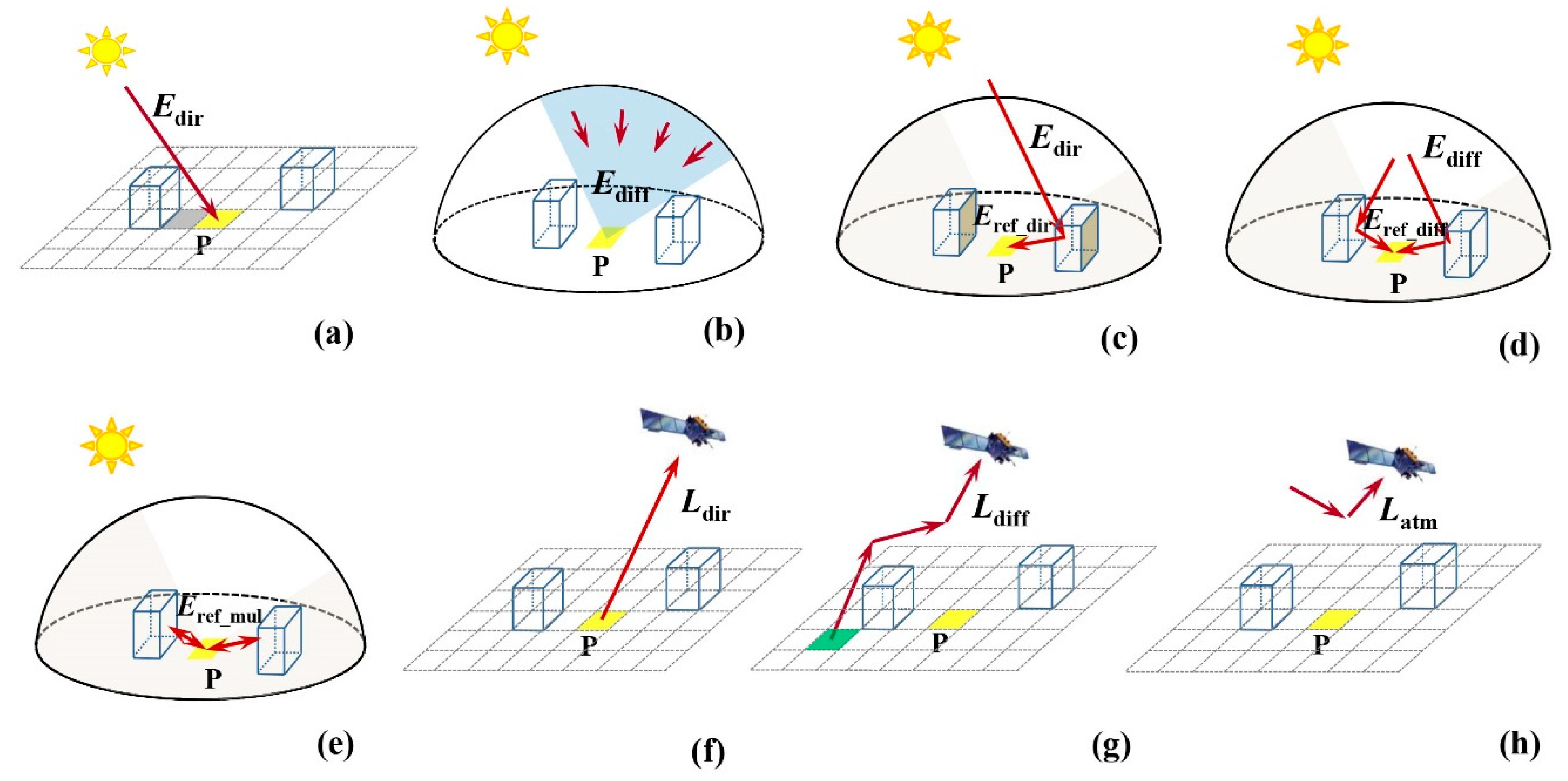
2.1. Description of the USRT Model
2.1.1. The Total Radiation Received by the Target Pixel
2.1.2. The Radiance Reaching the Sensor
2.2. Reflectance Calculation Model Based on the USRT Model
3. Study Area and Data
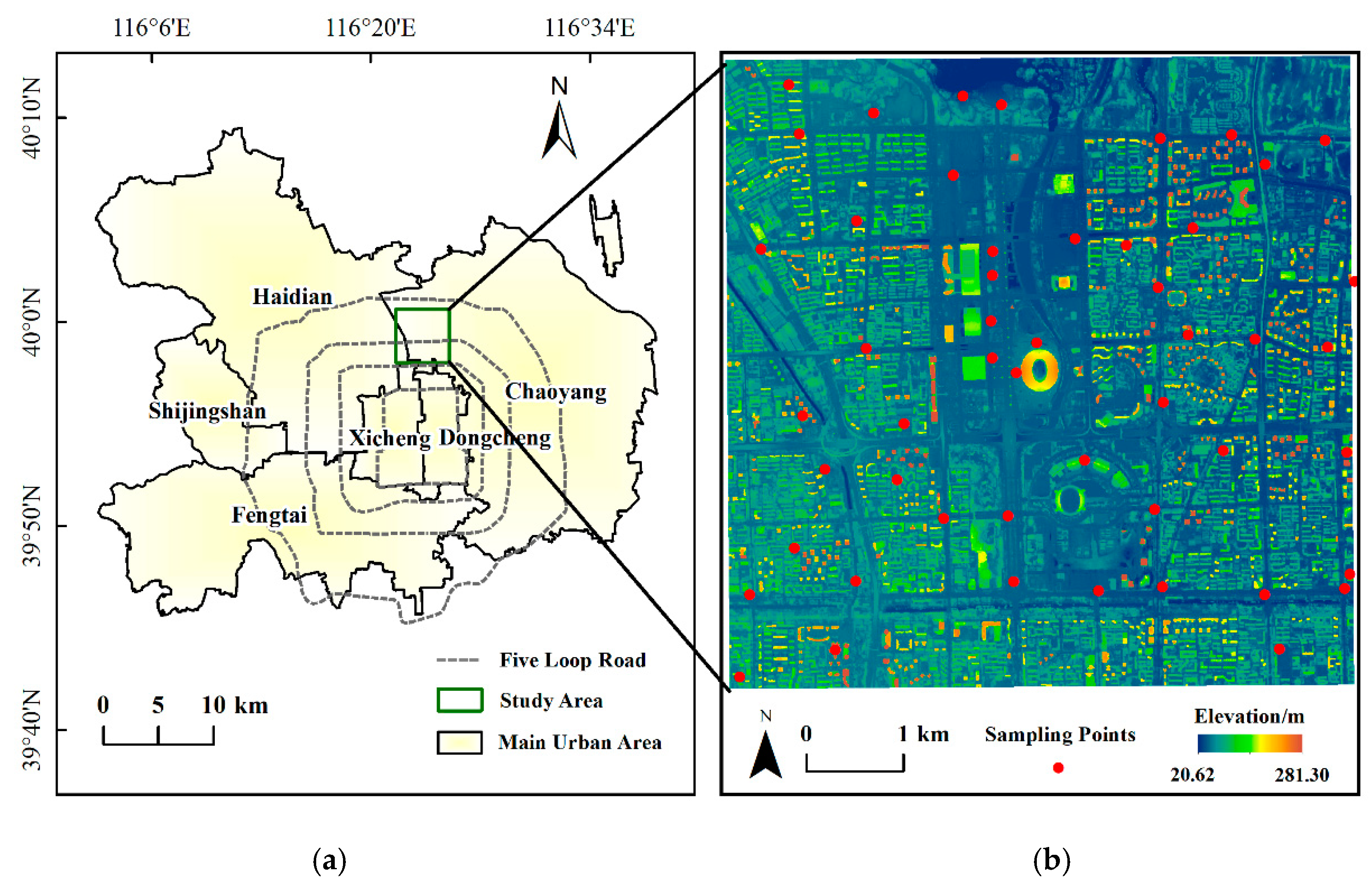
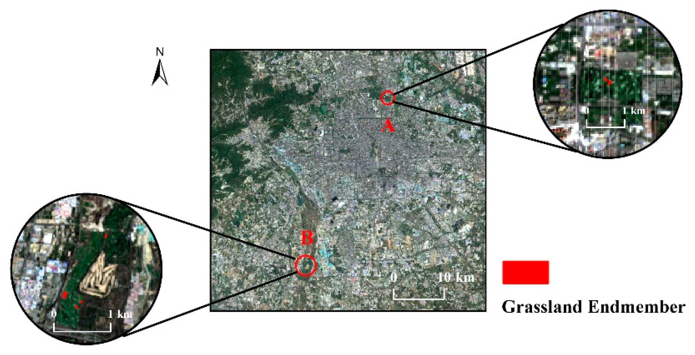
3.1. Study Area
3.2. Data
4. Data Processing and Result Analysis
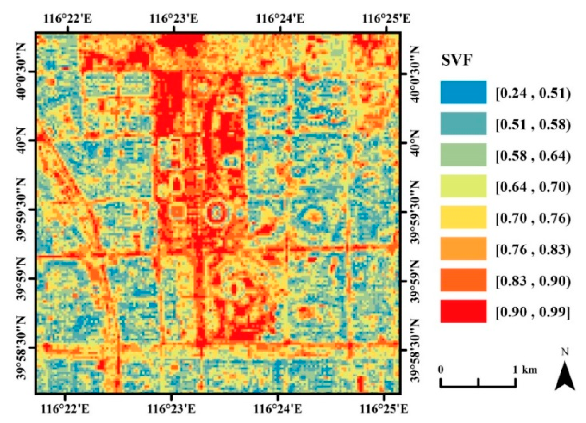
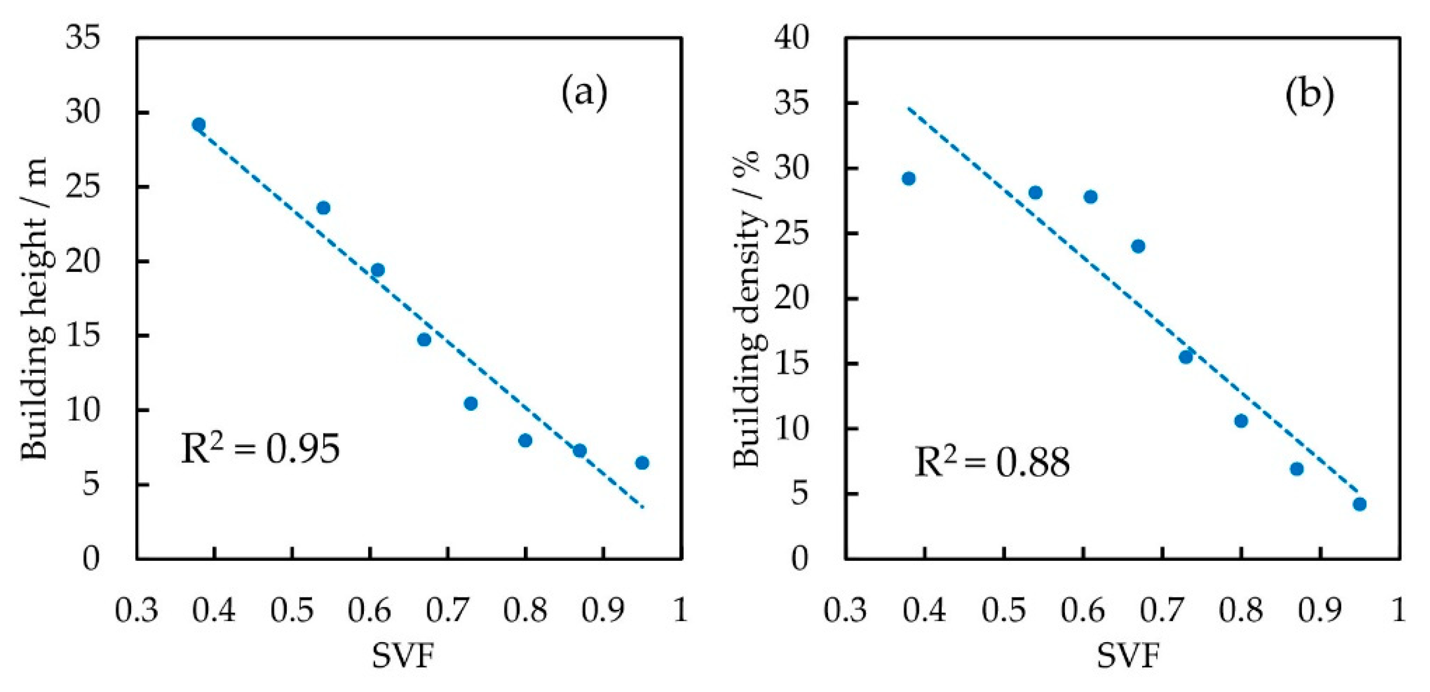
4.1. Results and Analysis of the SVF
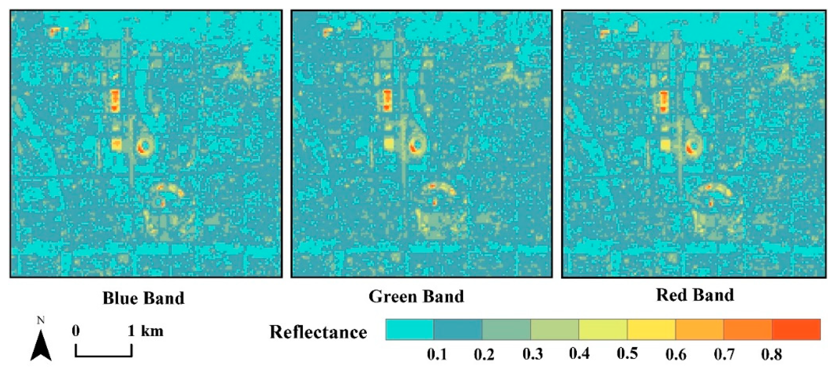
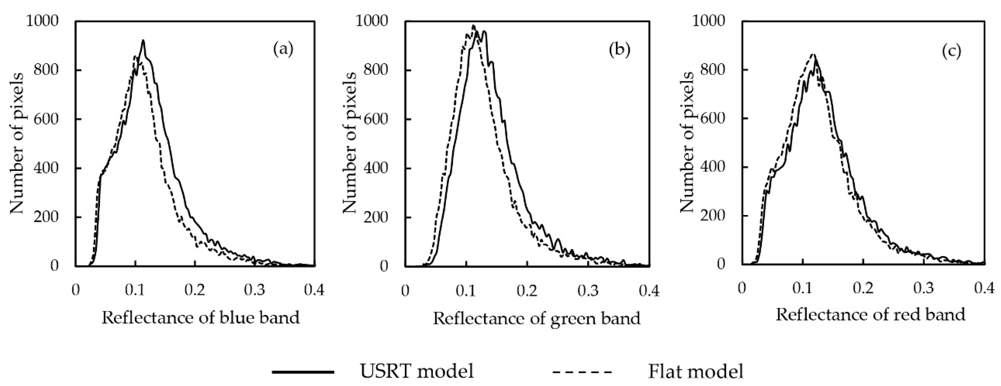
4.2. Results and Analysis of Urban 3D Surface Reflectance
5. Discussion
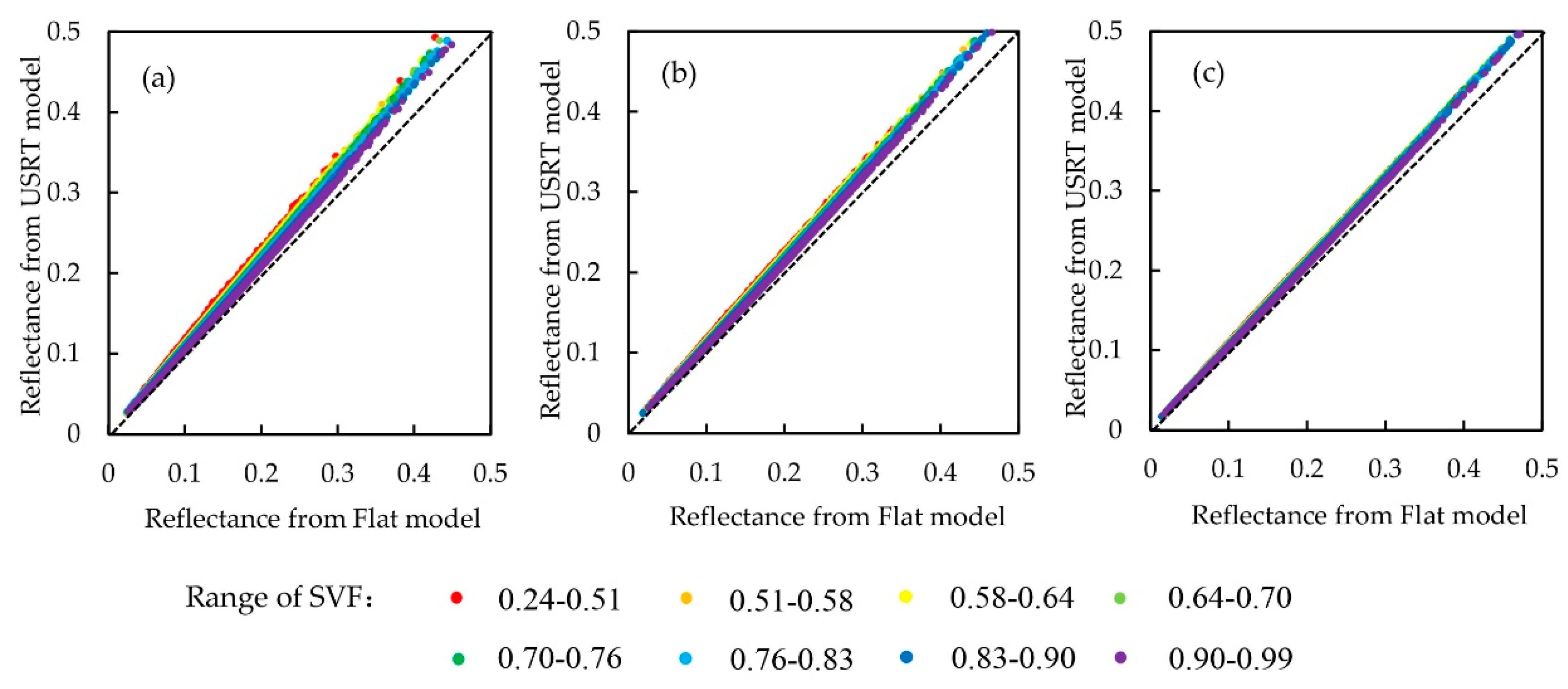
5.1. The Impact of the SVF on Urban 3D Surface Reflectance
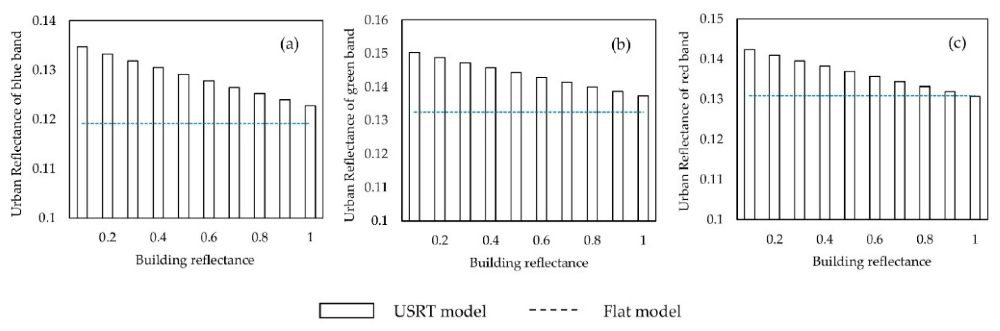
5.2. The Impcat of Building Reflectance on Urban 3D Surface Reflectance
6. Summaries
Author Contributions
Funding
Conflicts of Interest
References
- Bonczak, B.; Kontokosta, C.E. Large-scale parameterization of 3D building morphology in complex urban landscapes using aerial LiDAR and city administrative data. Comput. Environ. Urban Syst. 2019, 73, 126–142. [Google Scholar] [CrossRef]
- Yang, J.; Wong, M.; Menenti, M.; Nichol, J. Modeling the effective emissivity of the urban canopy using sky view factor. ISPRS-J. Photogramm. Remote Sens. 2015, 105, 211–219. [Google Scholar] [CrossRef]
- Gál, T.; Unger, J. A new software tool for SVF calculations using building and tree-crown databases. Urban Clim. 2014, 10, 594–606. [Google Scholar] [CrossRef]
- Cai, G.; Liu, Y.; Du, M. Impact of the 2008 Olympic Games on urban thermal environment in Beijing, China from satellite images. Sustain. Cities Soc. 2017, 32, 212–225. [Google Scholar] [CrossRef]
- Park, C.; Schade, G.W.; Werner, N.D.; Sailor, D.J.; Kim, C. Comparative estimates of anthropogenic heat emission in relation to surface energy balance of a subtropical urban neighborhood. Atmos. Environ. 2016, 126, 182–191. [Google Scholar] [CrossRef]
- Zhou, Y.; Weng, Q.; Gurney, K.R.; Shuai, Y.; Hu, X. Estimation of the relationship between remotely sensed anthropogenic heat discharge and building energy use. ISPRS-J. Photogramm. Remote Sens. 2012, 67, 65–72. [Google Scholar] [CrossRef]
- Liu, Q.; Cao, B.; Zeng, Y.; Li, J.; Du, Y.; Wen, J.; Fan, W.; Zhao, J.; Yang, L. Recent progress on the remote sensing radiative transfer modeling over heterogeneous vegetation canopy. J. Remote Sens. 2016, 20, 933–945. [Google Scholar]
- Wang, K.; Dickinson, R.E. Contribution of solar radiation to decadal temperature variability over land. Proc. Natl. Acad. Sci. USA 2013, 110, 14877–14882. [Google Scholar] [CrossRef] [PubMed]
- Wu, S.; Wen, J.; Gastellu-Etchegorry, J.; Liu, Q.; You, D.; Xiao, Q.; Hao, D.; Lin, X.; Yin, T. The definition of remotely sensed reflectance quantities suitable for rugged terrain. Remote Sens. Environ. 2019, 225, 403–415. [Google Scholar] [CrossRef]
- Wen, J.; Liu, Q.; Xiao, Q.; Liu, Q.; You, D.; Hao, D.; Wu, S.; Lin, X. Characterizing land surface anisotropic reflectance over rugged terrain: A review of concepts and recent developments. Remote Sens. 2018, 10, 370. [Google Scholar] [CrossRef]
- Wen, J.; Liu, Q.; Tang, Y.; Dou, B.; You, D.; Xiao, Q.; Liu, Q. Modeling land surface reflectance coupled BRDF for HJ-1/CCD data of rugged terrain in Heihe river basin, China. IEEE J. Sel. Top. Appl. Earth Obs. Remote Sens. 2015, 8, 1506–1518. [Google Scholar] [CrossRef]
- Wen, J.; Liu, Q.; Xiao, Q.; Liu, Q.; Li, X. Modeling the land surface reflectance for optical remote sensing data in rugged terrain. Sci. China Ser. D Earth Sci. 2008, 51, 1169–1178. [Google Scholar] [CrossRef]
- Mousivand, A.; Verhoef, W.; Menenti, M.; Gorte, B. Modeling top of atmosphere radiance over heterogeneous non-lambertian rugged terrain. Remote Sens. 2015, 7, 8019–8044. [Google Scholar] [CrossRef]
- Wang, Q.; Li, P. Canopy vertical heterogeneity plays a critical role in reflectance simulation. Agric. For. Meteorol. 2013, 169, 111–121. [Google Scholar] [CrossRef]
- Chen, M.; Seow, K.L.C.; Briottet, X.; Pang, S.K. Efficient empirical reflectance retrieval in urban environments. IEEE J. Sel. Top. Appl. Earth Obs. Remote Sens. 2013, 6, 1596–1601. [Google Scholar] [CrossRef]
- Yi, C.; Zhang, Y.; Wu, Q.; Xu, Y.; Remil, O.; Wei, M.; Wang, J. Urban building reconstruction from raw LiDAR point data. Comput.-Aided Des. 2017, 93, 1–14. [Google Scholar] [CrossRef]
- Zeng, Y.; Li, J.; Liu, Q.; Huete, A.; Yin, G.; Xu, B.; Fan, W.; Zhao, J.; Yan, K.; Mu, X. A radiative transfer model for heterogeneous agro-forestry scenarios. IEEE Trans. Geosci. Remote Sens. 2016, 54, 4613–4628. [Google Scholar] [CrossRef]
- Gonzalez-Aguilera, D.; Crespo-Matellan, E.; Hernandez, L.D.; Rodríguez-Gonzálvez, P. Automated urban analysis based on lidar-derived building models. IEEE Trans. Geosci. Remote Sens. 2013, 51, 1844–1851. [Google Scholar] [CrossRef]
- Machete, R.; Falcão, A.P.; Gomes, M.G.; Rodrigues, A.M. The use of 3d GIS to analyse the influence of urban context on buildings’ solar energy potential. Energy Build. 2018, 177, 290–302. [Google Scholar] [CrossRef]
- Overby, M.; Willemsen, P.; Bailey, B.N.; Halverson, S.; Pardyjak, E.R. A rapid and scalable radiation transfer model for complex urban domains. Urban Clim. 2016, 15, 24–44. [Google Scholar] [CrossRef]
- Best, M.J.; Grimmond, C.S.B. Analysis of the seasonal cycle within the first international urban land-surface model comparison. Bound.-Layer Meteor. 2013, 146, 421–446. [Google Scholar] [CrossRef]
- Zhu, S.; Guan, H.; Bennett, J.; Clay, R.; Ewenz, C.; Benger, S.N.; Maghrabi, A.H.; Millington, A. Influence of sky temperature distribution on sky view factor and its applications in urban heat island. Int. J. Climatol. 2013, 33, 1837–1843. [Google Scholar] [CrossRef]
- Wang, Y.; Akbari, H. Effect of sky view factor on outdoor temperature and comfort in Montreal. Environ. Eng. Sci. 2014, 31, 272–287. [Google Scholar] [CrossRef]
- Yang, F.; Qian, F.; Lau, S.S.Y. Urban form and density as indicators for summertime outdoor ventilation potential: A case study on high-rise housing in Shanghai. Build. Environ. 2013, 70, 122–137. [Google Scholar] [CrossRef]
- Cai, Z.; Han, G. Assessing land surface temperature in the mountain city with different urban spatial form based on local climate zone scheme. Mt. Res. 2018, 36, 617–627. [Google Scholar]
- Zhang, H.; Zhu, S.; Gao, Y.; Zhang, G. The relationship between urban spatial morphology parameters and urban heat island intensity under fine weather condition. J. Appl. Meteorol. Sci. 2016, 27, 249–256. [Google Scholar]
- Grimmond, C.S.B.; Potter, S.K.; Zutter, H.N.; Souch, C. Rapid methods to estimate sky-view factors applied to urban areas. Int. J. Climatol. 2001, 21, 903–913. [Google Scholar] [CrossRef]
- Brown, M.J.; Grimmond, S.; Ratti, C. Comparison of Methodologies for Computing Sky View Factor in Urban Environments; Internal Report Los Alamos National Laboratory: Los Alamos, NM, USA, 2001. [Google Scholar]
- Taleghani, M.; Kleerekoper, L.; Tenpierik, M.; Dobbelsteen, A.V.D. Outdoor thermal comfort within five different urban forms in the Netherlands. Build. Environ. 2015, 83, 65–78. [Google Scholar] [CrossRef]
- Yang, J.; Wong, M.; Menenti, M.; Nichol, J.; Voogt, J.; Krayenhoff, E.S.; Chan, P. Development of an improved urban emissivity model based on sky view factor for retrieving effective emissivity and surface temperature over urban areas. ISPRS-J. Photogramm. Remote Sens. 2016, 122, 30–40. [Google Scholar] [CrossRef]
- Yang, X.; Li, Y. The impact of building density and building height heterogeneity on average urban albedo and street surface temperature. Build. Environ. 2015, 90, 145–156. [Google Scholar] [CrossRef]
- Guo, G.; Zhou, X.; Wu, Z.; Xiao, R.; Chen, Y. Characterizing the impact of urban morphology heterogeneity on land surface temperature in Guangzhou, China. Environ. Model. Softw. 2016, 84, 427–439. [Google Scholar] [CrossRef]
- Zeng, L.; Lu, J.; Li, W.; Li, Y. A fast approach for large-scale sky view factor estimation using street view images. Build. Environ. 2018, 135, 74–84. [Google Scholar] [CrossRef]
- Zakšek, K.; Oštir, K.; Kokalj, Ž. Sky-view factor as a relief visualization technique. Remote Sens. 2011, 3, 398–415. [Google Scholar] [CrossRef]
- Duan, X.; Hu, D.; Cao, S.; Yu, C.; Zhang, Y. A study of the parametric method of sky view factor on complex underlying surface in urban area: A case study of national sport stadium area in Beijing. Remote Sens. Land Resour. 2019, 31, 29–35. [Google Scholar]
- Chen, L.; Ng, E.; An, X.; Ren, C.; Lee, M.; Wang, U.; Ho, J.C.K. Sky view factor analysis of street canyons and its implications for daytime intra-urban air temperature differentials in high-rise, high-density urban areas of Hong Kong: A GIS-based simulation approach. Int. J. Climatol. 2012, 32, 121–136. [Google Scholar] [CrossRef]
- Groleau, D.; Mestayer, P.G. Urban morphology influence on urban albedo: A revisit with the Solene model. Bound.-Layer Meteor. 2012, 147, 301–327. [Google Scholar] [CrossRef]
- Scarano, M.; Sobrino, J.A. On the relationship between the sky view factor and the land surface temperature derived by Landsat-8 images in Bari, Italy. Int. J. Remote Sens. 2015, 36, 4820–4835. [Google Scholar] [CrossRef]


| Band | |||||
|---|---|---|---|---|---|
| Blue (0.450–0.515 μm) | 1908.283 | 44.460 | 0.472 | 0.213 | 0.709 |
| Green (0.525–0.600 μm) | 1787.567 | 24.983 | 0.570 | 0.184 | 0.752 |
| Red (0.630–0.680 μm) | 1524.643 | 14.101 | 0.650 | 0.152 | 0.801 |
| SVF | Blue Band (0.450–0.515 μm) | Green Band (0.525–0.600 μm) | Red Band (0.630–0.680 μm) |
|---|---|---|---|
| [0.24, 0.51) | 0.142 | 0.150 | 0.151 |
| [0.51, 0.58) | 0.138 | 0.152 | 0.143 |
| [0.58, 0.64) | 0.133 | 0.151 | 0.142 |
| [0.64, 0.70) | 0.131 | 0.143 | 0.143 |
| [0.70, 0.76) | 0.120 | 0.139 | 0.130 |
| [0.76, 0.83) | 0.124 | 0.142 | 0.131 |
| [0.83, 0.90) | 0.132 | 0.153 | 0.142 |
| [0.90, 0.99] | 0.151 | 0.170 | 0.162 |
| Band | USRT Model | Flat Model | Flat Model |
|---|---|---|---|
| Urban Area | Urban Area | Suburban Area | |
| Blue (0.450–0.515 μm) | 0.074 | 0.073 | 0.076 |
| Green (0.525–0.600 μm) | 0.116 | 0.110 | 0.118 |
| Red (0.630–0.680 μm) | 0.071 | 0.068 | 0.076 |
Publisher’s Note: MDPI stays neutral with regard to jurisdictional claims in published maps and institutional affiliations. |
© 2020 by the authors. Licensee MDPI, Basel, Switzerland. This article is an open access article distributed under the terms and conditions of the Creative Commons Attribution (CC BY) license (http://creativecommons.org/licenses/by/4.0/).
Share and Cite
Hu, D.; Liu, M.; Di, Y.; Yu, C.; Wang, Y. USRT: A Solar Radiative Transfer Model Dedicated to Estimating Urban 3D Surface Reflectance. Urban Sci. 2020, 4, 66. https://doi.org/10.3390/urbansci4040066
Hu D, Liu M, Di Y, Yu C, Wang Y. USRT: A Solar Radiative Transfer Model Dedicated to Estimating Urban 3D Surface Reflectance. Urban Science. 2020; 4(4):66. https://doi.org/10.3390/urbansci4040066
Chicago/Turabian StyleHu, Deyong, Manqing Liu, Yufei Di, Chen Yu, and Yichen Wang. 2020. "USRT: A Solar Radiative Transfer Model Dedicated to Estimating Urban 3D Surface Reflectance" Urban Science 4, no. 4: 66. https://doi.org/10.3390/urbansci4040066
APA StyleHu, D., Liu, M., Di, Y., Yu, C., & Wang, Y. (2020). USRT: A Solar Radiative Transfer Model Dedicated to Estimating Urban 3D Surface Reflectance. Urban Science, 4(4), 66. https://doi.org/10.3390/urbansci4040066