1. Introduction
Traffic congestion is a global asset planning and management challenge driven by urban sprawl and rapid traffic growth. Traffic congestion on highways, including at toll plazas, led to the loss of over 4.3 billion hours of commuter time and resulted in a productivity loss exceeding 101 billion USD in 2020 [
1]. Similarly, the European Commission estimates an annual cost of over 110 billion EUR due to highway congestion, accounting for 1% of Europe’s GDP [
2]. Pakistan’s motorway and highway network carry approximately 80% of the total traffic. Therefore, congestion at toll plazas on motorways and highways imposes a significant cost [
3,
4]. Moreover, vehicular emissions and local air pollution concentrations are generally higher when vehicles are queued at toll plazas or in stop-and-go traffic compared to free-flowing conditions [
5,
6]. Consequently, high-demand-induced traffic congestion at toll plazas significantly impacts travel time [
7] and infrastructure mobility and triggers severe environmental [
8,
9], social, and economic repercussions [
10].
Toll plazas play a pivotal role in contemporary transportation systems, functioning as gateways that ensure traffic fluidity and generate revenue through toll fees. These are critical for maintaining and expanding essential road networks. However, these toll plazas often encounter challenges linked to traffic congestion, resulting in lengthy queues, prolonged travel times, and adverse environmental impacts. Intelligent transportation systems (ITSs) have been proposed with advances in artificial intelligence (AI) to manage traffic flow efficiently and reduce congestion. For instance, studies have proposed control measures to optimize traffic flow and reduce congestion. Some studies mainly focused on implementing strategies like electronic toll collection (ETC), lane configuration, and freeway capacity control techniques to optimize traffic flow and mitigate congestion at toll plazas. However, these solutions to alleviate traffic congestion encounter high costs, right-of-way (ROW) issues, technical complexities, and inadequate real-time toll plaza capacity consideration. Failure to account for current traffic conditions at toll plazas can result in inefficient traffic management systems, leading to congestion and delays, particularly during peak hours.
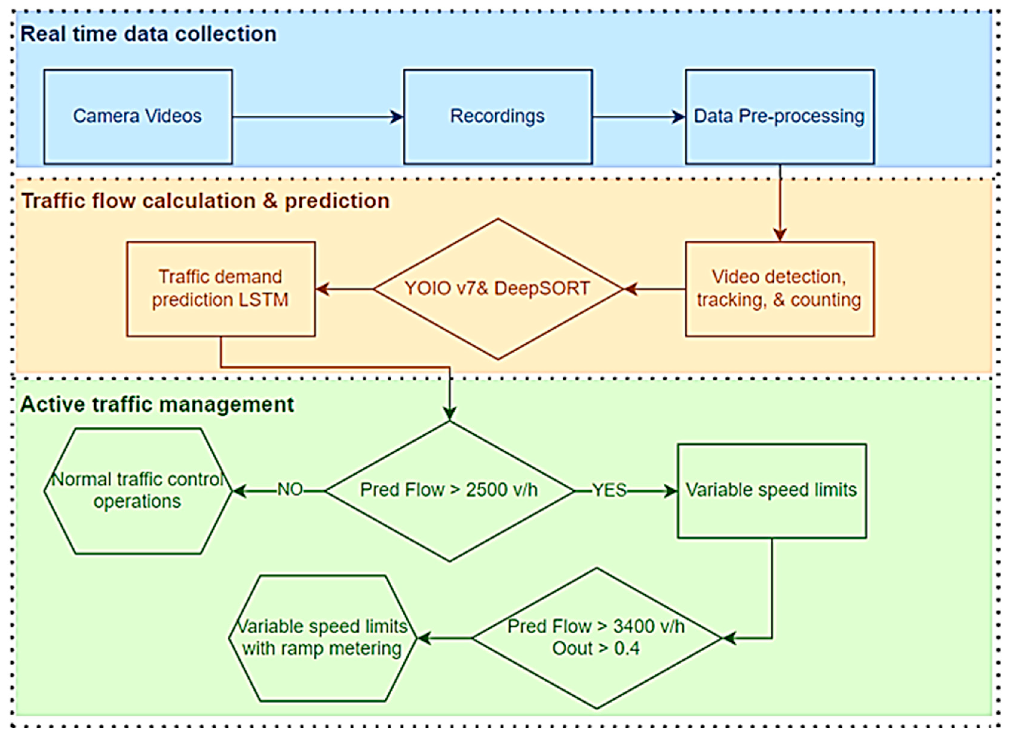
Identifying the limitations of previous approaches and aiming to mitigate adverse toll plaza congestion, this study proposes a novel proactive traffic control approach for preemptive management of traffic demand and flow at toll plazas. The first phase of this proactive strategy entails accurate vehicle counting through video cameras. This study utilizes two deep learning convolutional neural network (CNN) models: YOLOv7 and Deep SORT. YOLOv7 handles vehicle detection, accurately recognizing vehicles within a frame, while Deep SORT manages vehicle tracking across consecutive frames. Subsequent postprocessing refines the models’ outcomes to ensure accurate vehicle counting and calculation of the arrival rate. For better traffic management, this study examines variations in arrival rates across weekdays. It utilizes the long short-term memory (LSTM) model for short-term predictions of arrival rates within the next 15 min.
This predictive model aids in estimating the anticipated vehicle arrival rate, thus facilitating real-time traffic management. A combination of variable speed limits (VSLs) and ALINEA ramp metering (RM) control strategies are implemented at the toll plaza when the arrival rate exceeds a predefined threshold to regulate vehicle flow during peak hours. The primary objectives of this study encompass a comprehensive approach to traffic demand management and environmental sustainability. It aims to optimize traffic demand through proactive strategies like ramp metering to regulate the merging rate of vehicles onto the main freeway lanes and prevent excessive queue formation at toll plazas. Integrating variable speed limits (VSLs) allows real-time adjustments to speed limits, ensuring smoother traffic flow. Furthermore, the study seeks to minimize the environmental impact of congestion by optimizing traffic flow, thereby decreasing fuel consumption and emissions through reduced idling and stop-and-go traffic. It ultimately contributes to a more sustainable and eco-friendly transportation system.
The case study focused on the Ravi Toll Plaza in Lahore to validate the efficiency of the proposed control strategy. This toll plaza stands as one of the country’s busiest, located at the exit of the M-2 motorway connecting the major metropolitan cities of Lahore and Islamabad. Given its substantial traffic volume and diverse traffic patterns, it is an ideal testing ground for the proposed control strategy. This investigation employs PTV-VISSIMv7 to replicate outcomes. A VISSIMv7 model was formulated for Ravi Toll Plaza, and the control strategy algorithm was integrated using VisVAP 2.16 software. This simulation offers a realistic environment to evaluate the proposed control strategy’s effectiveness and influence on traffic flow.
The study compares various scenarios for simulation results: the existing condition, VSLs only, RM only, and the proposed strategy (i.e., both VSLs and RM). It demonstrates a comparative analysis wherein the proposed strategy outperforms all other scenarios. It offers the most efficient and practical approach to traffic flow management at Ravi Toll Plaza and potentially other similarly busy toll plazas. The results validate the significance of combining advanced computer vision (YOLOv7–Deep SORT), predictive modeling (LSTM), and control strategies (VSL–RM) to enhance traffic management and optimize toll plaza operation.
This article is organized into several sections that explore various aspects of traffic flow estimation, proactive control strategies, and their implementation. The Literature Review section provides insights into current research on traffic flow estimation techniques, highlighting advancements in deep learning models for traffic demand forecasting. The Methodology section outlines traffic flow estimation methodologies and the application of proactive control strategies, including variable speed limits and ramp metering. Subsequently, the Simulation Model Development section presents the study site, data collection methods, and the development and calibration of simulation models. The Results and Discussion sections analyze the impact of proposed strategies on traffic and environmental factors, while recommendations and limitations offer insights into practical implications and potential avenues for future research. Finally, the Conclusions section summarizes key findings.
2. Literature Review
Numerous studies have investigated and optimized toll plaza operations using different tools and simulation software. Most studies used PTV VISSIM microsimulation software to model toll operations [
11,
12,
13]. Similarly, Oskarbski et al. used PTV VISSIM software to analyze the toll plaza’s safety, traffic efficiency, and driver behavior [
14]. At the same time, some studies modeled microsimulations based on the PARAMICS program [
15]. The TPSIM microsimulation program was also used to model toll booth areas [
16].
Additionally, microsimulation models within VISSUM software were used by Aksoy et al. and Xing et al. to analyze toll booth performance and mitigate traffic congestion effects [
17,
18]. Xing et al. built an optimization model to configure a toll lane that considers various payment methods and vehicle-type proportions [
18]. Özdemir et al. showcased decreased delay values with electronic toll collection over manual toll booths [
19]. Furthermore, microsimulations have effectively demonstrated their utility in evaluating toll plazas using traffic control strategies such as plate recognition technology [
20], separating passenger cars and heavy vehicles [
20,
21] and employing ETC system applications [
22].
Traditional transportation studies relied on specialized sensors such as magnetic coils and ultrasonic detectors for vehicle counting. However, these sensors have limitations in capturing detailed information and are expensive to install [
23]. The advancement in computer vision and image processing technologies offers video-based vehicle counting with a wider range of traffic parameters, including vehicle category, density, and speed. These are cost-effective, easy to install, and simple to maintain [
24]. The computer vision method for vehicle counting encompasses three integrated procedures: detection, tracking, and trajectory processing [
25].
Detection-based methods encompass four main categories, which are frame difference [
26], optical flow [
27], background subtraction (BS) [
28], and convolutional neural networks (CNNs) [
29]. CNNs have emerged as a popular object detection technique, achieving significant advancements in vehicle detection and tracking [
30]. Utilizing GPUs, CNNs have become the leading approach for accurate vehicle detection and classification, effectively handling complex appearance changes and occlusions [
31]. Researchers have extensively employed CNN-based approaches for vehicle counting. For instance, Alghyaline et al. proposed a YOLO-based approach for object detection combined with Kalman filtering and the Hungarian algorithm for tracking [
32]. Xiang et al. presented a vehicle counting framework using aerial videos from UAVs, offering flexibility in deployment and a larger perspective for traffic monitoring compared to traditional sensors [
33].
Similarly, Z. Dai et al. developed a video-based vehicle counting framework comprising object detection, tracking, and trajectory processing, yielding accurate traffic flow data [
23]. Mandal and Adu-Gyamfi explored video-based vehicle counting through object detection and tracking algorithms, achieving precise counts with YOLOv4 and Deep SORT [
25]. Leveraging the development of YOLOv5, Ren and Chen proposed a deep learning model based on YOLOv5 and Deep SORT for vehicle detection and tracking, resulting in enhanced accuracy [
34].
Vehicle detection and classification advancements significantly enhance proactive freeway traffic control strategies, improving traffic efficiency and safety throughout existing infrastructure. These controls utilize real-time data, coordinating various methods based on short-term traffic flow forecasting to manage demand and mitigate accident risks [
35]. For instance, Anjaneyulu and Kubendiran’s proposed study presents a hybrid Xception support vector machine (XPSVM) classifier model with a high accuracy rate for short-term traffic congestion prediction [
36]. Abdullah et al. proposed a bidirectional recurrent neural network (BRNN) using gated recurrent units (GRUs) for simulating and forecasting traffic congestion in smart cities, aiming to improve traffic management efficiency [
37].
Various strategies, such as VSL, ramp metering (RM), and integrated controls, have emerged recently. For example, Oskarbski et al. used surrogate safety measures and simulation techniques to analyze how VSLs impact motorways and expressways [
38]. Additionally, a methodology had been proposed using surrogate safety measures to assess the effects of ramp metering and other ITS services on traffic safety and efficiency across different road network scales [
39]. Similarly, Joo and Lim proposed an intelligent traffic signal control system using deep Q-network reinforcement learning to optimize signal sequencing, aiming to alleviate traffic congestion by maximizing throughput and considering queue length standard deviation as reward parameters [
40].
Many researchers proposed VSLs combined with other ITS techniques; for instance, Frejo et al. designed a VSL method based on a second-order discrete macroscopic traffic model, META-NET, analyzing VSLs’ impact on freeway traffic flow by accounting for segment capacities, critical densities, and driver compliance [
41], and Han et al. proposed VSL control with ITS control strategies using reinforcement learning methods [
42]. Similarly, Fares et al. used reinforcement learning to coordinate VSL and RM controls, alleviating freeway network congestion [
43]. Han et al. integrated future traffic flow predictions and applied a discrete first-order model to predict future traffic flow and optimize freeway variable speed limits (VSLs) [
44,
45].
Similarly, Vrbanić et al. proposed a CD-QL-DPVSL control approach that demonstrates improved traffic management and safety on urban motorways through dynamic congestion detection and variable speed limit optimization using connected autonomous vehicles [
46]. Moreover, Gregurić et al. proposed STM-QL-DVSL algorithm leverages Q-learning and speed transition matrices (STMs) with CAVs to optimize variable speed limit control, surpassing other strategies by adapting dynamically to various traffic scenarios [
46].
Limited research has focused on proactive traffic control at freeway toll plazas. Zhou et al. LSTM predicted traffic flow and implemented proactive control strategies, including variable speed limits (VSLs) and lane configuration before toll plazas [
47]. Meanwhile, both Spiliopoulou et al. and Papageorgiou et al. proposed a comprehensive conceptual framework for real-time merging traffic using the local ALINEA RM strategy, improving toll plaza efficiency by reducing vehicle delay and queue length. The framework demonstrated practical applicability [
48,
49]. Yuan proposed an integrated VSL–RM control strategy to enhance freeway mainline efficiency [
50]. This strategy coordinates traffic flow between the mainline and toll plaza, adjusting traffic density in the mainline merging zone.
The literature review reveals significant research gaps in vehicle counting and traffic management at toll plazas in developing countries. The use of deep learning CNN models for vehicle counting encounters limitations in efficiency, especially with low-resolution videos, making accurate counting a challenge in such surveillance footage. Secondly, some studies propose increasing the number of lanes for toll plaza optimization. However, this solution can be costly and may encounter right-of-way (ROW) issues, particularly in densely populated regions. Thirdly, specific approaches involve configuring lanes based on vehicle classification and payment methods like ETC and MTC.
However, challenges arise when MTC-equipped vehicles use ETC lanes and vice versa due to a lack of awareness and education among the population in developing countries. Lastly, some research offers proactive control solutions using RM and VSLs to manage freeway or mainline capacity without considering the actual real-time capacity at the toll plaza. Neglecting the current traffic load at the toll plaza can lead to an inefficient traffic management system, causing congestion and delays, particularly during peak hours. Furthermore, implementing these strategies in developing countries has been inflexible, with some lacking a well-defined implementation scheme.
Our proposed study addresses the limitations of previous approaches. It employs the latest YOLO, YOLOv7, in conjunction with Deep SORT to achieve high accuracy in vehicle detection, tracking, and counting. Additionally, this study proposes an integrated control method to implement variable speed limits (VSLs) and ramp metering (RM) while considering real-time capacity at the toll plaza area.
Dynamically adjusting traffic flow by VSLs and regulating vehicle entry via RM, this proactive approach aims to reduce delays and congestion during peak hours, leading to a smoother traffic experience for motorway commuters at the toll plaza section. Moreover, the study provides a well-defined implementation scheme, demonstrating its feasibility and ease of installation in developing countries. This comprehensive strategy holds significant promise in optimizing toll plaza operations, addressing unique challenges, and benefiting travelers and toll operators alike.
4. Simulation Model Development
4.1. Study Site
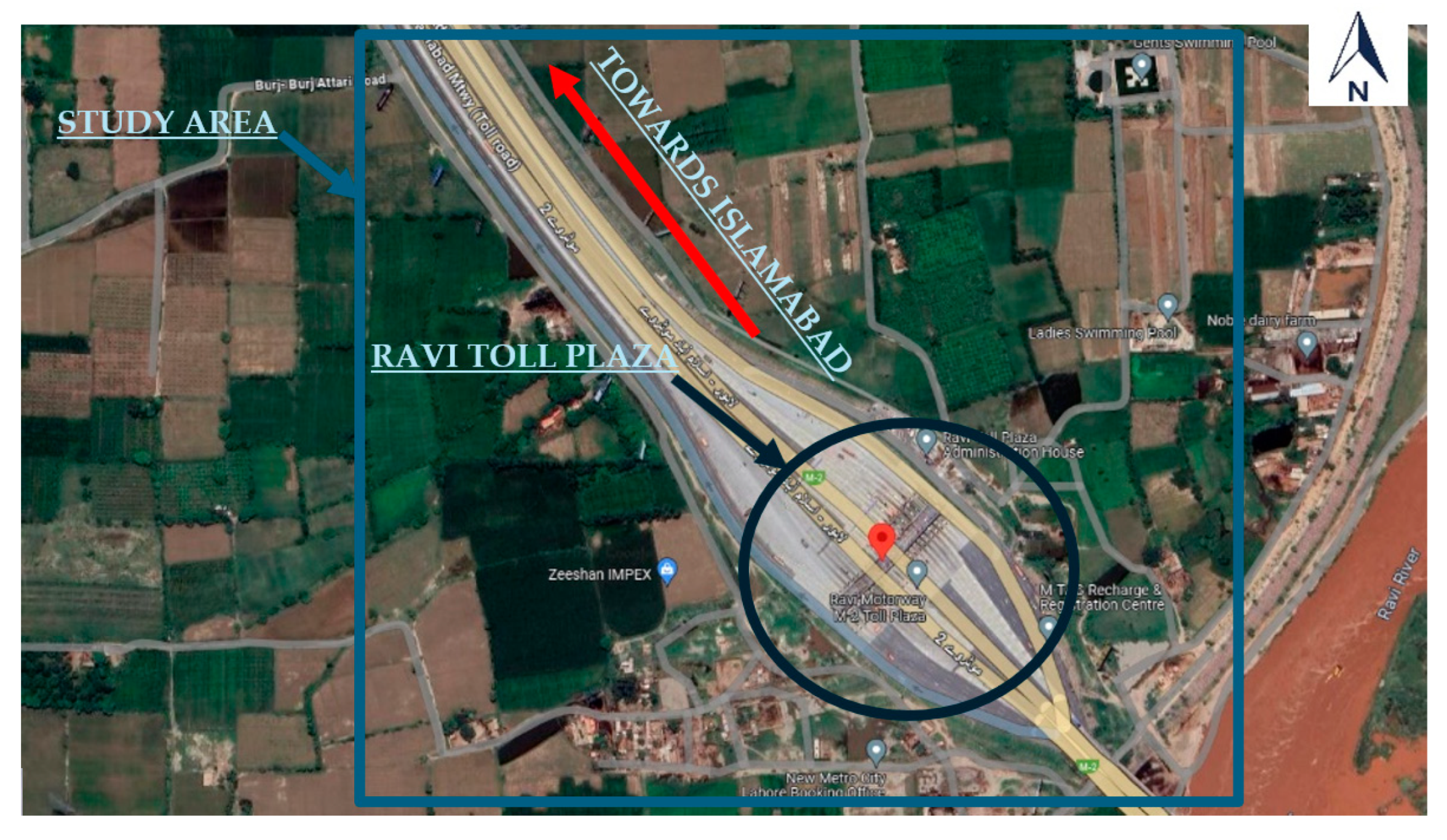
The selected site for this study is the Ravi Toll Plaza in Lahore, Pakistan, which serves as a hybrid toll plaza on the M-2 motorway, connecting two metropolitan cities: Islamabad and Lahore. This toll plaza encompasses 540 m, including diverging and merging sections. It comprises 25 lanes, with 15 designated for traffic bound for Lahore and 10 for traffic headed to Islamabad. The individual toll booths span a length of 140 m. This study aimed to effectively create a realistic and representative model of the Ravi Toll Plaza in PTV VISSIMv7 by incorporating geometric details.
All interchanges along the M-2 have been upgraded with an M-Tag (ETC) system for toll payment, and public awareness remains an issue that impacts system efficiency. Variable message signs (VMSs) are installed before the toll booths and can display lane types, such as ETC or MTC. The current study focuses exclusively on traffic flow in the exit direction, especially Lahore-bound. The site location is shown in
Figure 5.
4.2. Data Collection and Analysis
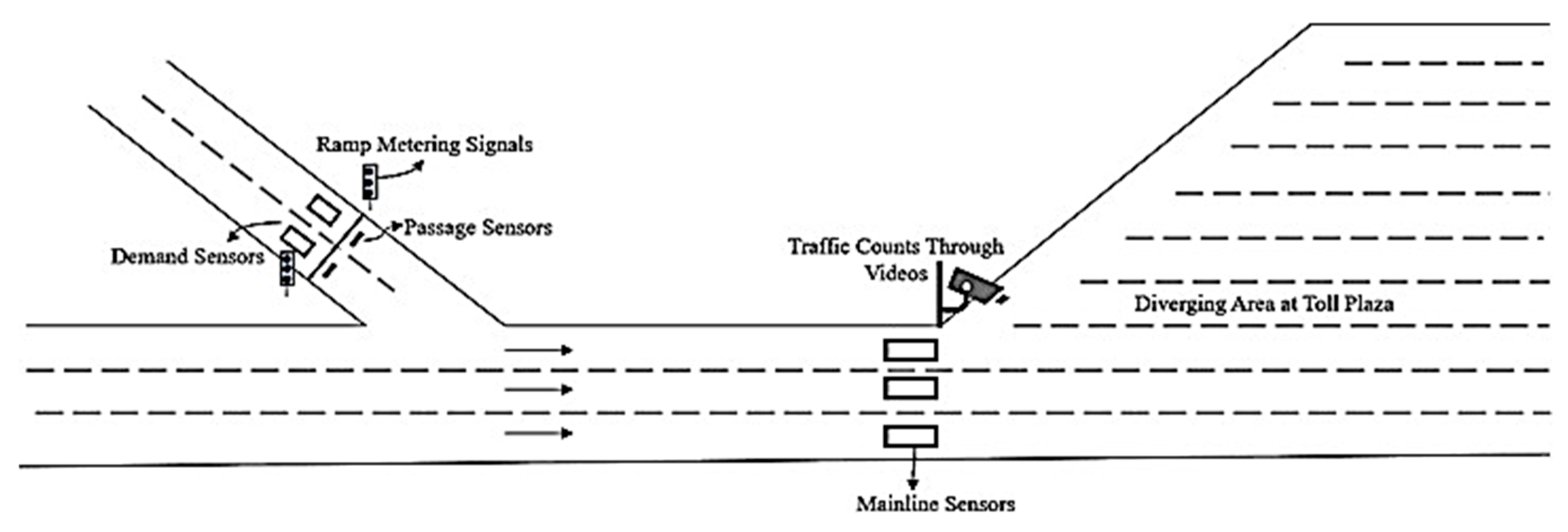
Video cameras were positioned to gather data at the toll plaza’s diverging section outsets, capturing vehicle trajectories. These data enabled the recognition of traffic patterns and the prediction of traffic flow and composition at the studied toll plaza section. The video footage spans a week, encompassing 168 h from 30 January to 5 February 2017. The decision to record video footage spanning a week was deliberate: to capture comprehensive traffic patterns allowing for identification of peak hours and overall trends over a typical week. The selection of a camera angle at approximately 30 degrees relative to the vehicles’ travel direction was strategic. This angle provided an optimal view of the toll plaza’s diverging area and supported our tracking algorithm (Deep SORT), enabling accurate vehicle tracking and trajectory prediction. The high quality of the recorded video, with dimensions of 720 pixels (width) by 480 pixels (height) and a frame rate of 29.5 frames per second, ensures clarity and precision in vehicle movement analysis.
Furthermore, our approach involved segmenting the collected data into 15 min intervals to facilitate detailed analysis of traffic flow dynamics. This granularity was essential for identifying peak traffic periods and served as input for the proposed LSTM (long short-term memory) model. Our LSTM model was trained to predict the arrival rate for the next 15 min by leveraging temporal traffic data, mainly focusing on peak hours. These considerations collectively formed a robust data collection framework tailored to our study objectives.
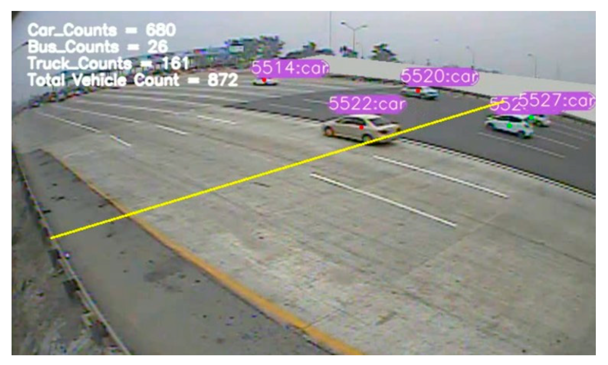
Once the camera videos were collected, preprocessing, decoding, frame resizing, and normalization were executed. Subsequently, the preprocessed videos were used as input for the YOLOv7–Deep SORT algorithm. This methodology enabled the acquisition of traffic counts for every 15 min interval. This process involved handling 168 videos, each spanning 1 h, culminating in the outcomes. A screenshot of the output video is shown in
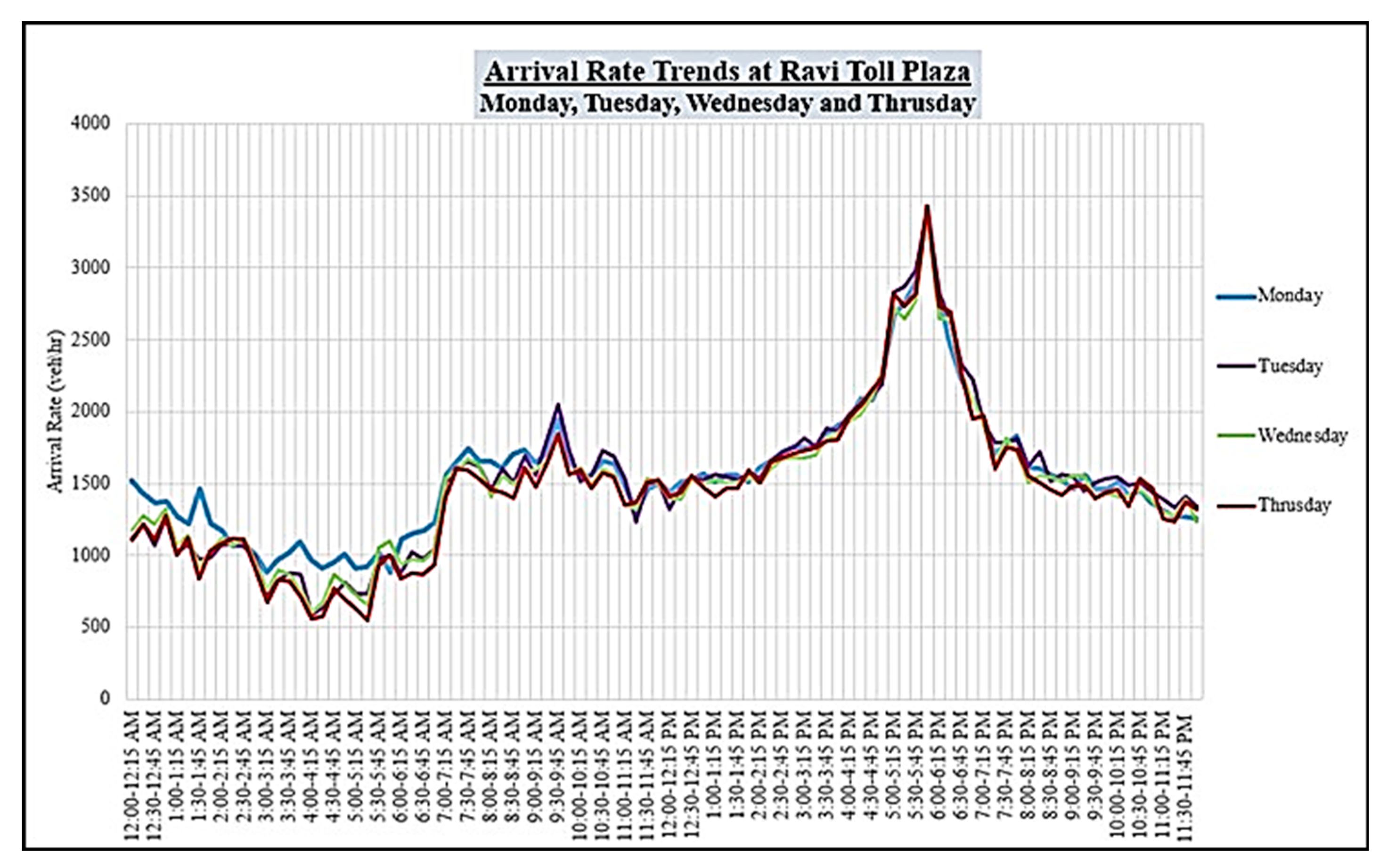
Figure 6. The result showed distinct traffic patterns. During weekdays, the morning and evening peaks start at 0800 and 1700 h, respectively. However, the morning and evening peaks begin at 1000 and 1900 h on weekends. The trend is shown in
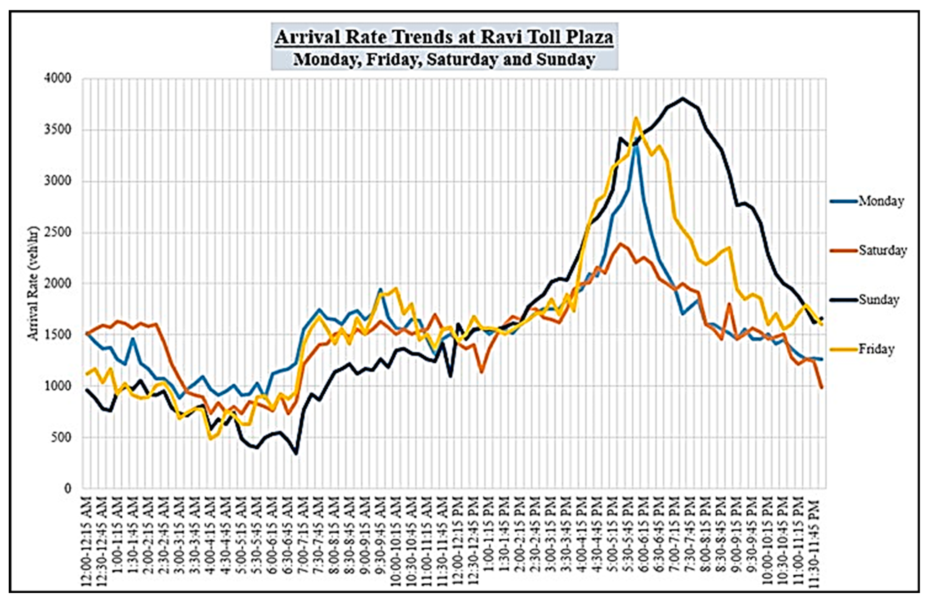
Figure 7. On weekdays, the observed maximum flow rate is 3400 vehicles per hour, whereas weekends witness a 3800 vehicles per hour flow rate, especially on Sundays.
Further data analysis revealed four distinct traffic flow trends. From Monday morning until Thursday, a consistent flow pattern prevails. Fridays show a noticeable deviation in flow pattern behavior, indicating a distinct traffic dynamic. Saturdays exhibit a unique flow trend distinct from weekdays, Fridays, and Sundays. Sundays display a flow trend entirely different from the rest of the week, as shown in
Figure 8. Additionally, the results of mode share analysis showed that across the entire week, 81.85% of incoming vehicles were passenger cars, while 10.8% constituted trucks and 7.3% were buses. Whereas these mode shares varied over time, the proportion of trucks and buses slightly increased during nighttime.
To evaluate the accuracy of the proposed traffic counting method, the vehicle counts obtained through this approach are compared with manually calculated counts. The process involved manually counting the number of vehicles passing through 15 min videos under different weather conditions, and these counts were then compared with the estimated counts derived through the proposed methodology. The outcomes of this comparison indicated a substantial degree of accuracy achieved by our approach. Significantly, under normal daylight conditions (sunlight), the approach exhibited an impressive accuracy of 91%. However, the accuracy dropped in other scenarios, with accuracy rates of 87% during morning dawn, 85% during evening twilight, 81% during the night, and 68% in foggy morning conditions, as shown in
Table 1.
Moreover, to enhance the comprehension of the accuracy achieved by the proposed counting approach, confusion matrices are utilized to evaluate the classification of vehicles and ascertain how effectively they have been counted. An illustration of the confusion matrix for the same 15 min video recorded under sunlight conditions is shown in
Figure 9.
Figure 9 displays the counts of true-positive (TP), true-negative (TN), false-positive (FP), and false-negative (FN) predictions generated by the algorithm. The results shown in the confusion matrix reveal that 98% of cars, 86% of trucks, and 70% of buses have been correctly counted.
After estimating the number of vehicles passing in 15 min intervals, the LSTM model underwent training by analyzing distinct trends for each day of the week to predict traffic counts for subsequent intervals. This evaluation yielded encouraging results, with the model achieving a mean squared error (MSE) of 128.18, a mean absolute error (MAE) of 8.55, and a root mean squared error (RMSE) of 11.93. The R-squared value of 0.94 indicated a strong correlation between the model’s predictions and traffic counts. It underscores the LSTM model’s capability to forecast traffic trends by leveraging the distinct day-specific trends learned during the training phase.
4.3. Model Development on PTV VISSIMv7
Microsimulation tests were carried out to validate the proposed integrated control method before its actual development. To this end, PTV VISSIMv7 software was used to simulate the proposed control strategies during peak hour at Ravi Toll Plaza. PTV VISSIMv7 has been widely recognized for its capacity to visually represent traffic flow across various modes. It is an exceptional tool for graphical presentations and detailed traffic flow analysis at specific points within a transportation system.
A detailed design process was undertaken to accurately model the system’s geometry in VISSIMv7 using links and connectors. The initial step involved importing and appropriately scaling a background image. Next, links and connectors were added to build the roadways. Specifically, two on-ramps were incorporated upstream of the mainline freeway section. Downstream, the toll plaza was meticulously designed. A zone for desired speed limits (variable speed limits) was introduced 8 km before the start of the toll VSL zone.
The study divided toll plaza sections in two: a diverging section spanning 238 m and a merging section extending over 220 m. Both sections were meticulously drafted in VISSIMv7 to mirror the as-built design accurately. With the diverging area, the 3-lane mainline link was subdivided into 15 toll lanes, seamlessly connected to the mainline link using connectors. Static routes were also assigned to every toll lane. This configuration allowed smooth traffic transition from the mainline to the toll lanes. A 60 km/h speed limit was considered to manage speed within the diverging section, ensuring safe and controlled vehicle movement.
Varying speed limits at the mainline motorway section were introduced: 120 km/h for cars, 110 km/h for buses, and 100 km/h for trucks, respectively. At the toll plaza, the dwell time of the stop sign was synchronized with service time. Moreover, queue counters and data collection points were placed before the stop sign to gather relevant data. This allowed the measurement of queue length and the count of vehicles passing through the toll plaza, providing essential insights into traffic flow and operational efficiency. Furthermore, collection points were integrated into the network to measure travel time across scenarios. Additionally, a node was formed throughout the network to ascertain vehicle delay and CO emissions.
The LSTM (long short-term memory) model’s predicted flow measurements considered the vehicle input for the network in VISSIMv7. A 40 percent expected flow was allocated as the vehicle input for both on-ramp links, while the remaining 60 percent was directed as the vehicle input for the mainline motorway link.
This study used default values for free lane selection for lane-changing behavior. Meanwhile, the driver behavior parameters (CC0, CC1, and CC2) of the Wiedemann 99 car-following model were calibrated and validated using PTV VISSIMv7 software to accurately replicate various driver behaviors, including following, merging, and diverging within specific roadway segments. The calibration involved adjusting these parameters to match observed driver behaviors captured from field data, e.g., a representative segment of the roadway and comparison of simulated vehicle trajectories with actual observed behaviors to fine-tune the model parameters. Validation was then performed to assess the model’s ability to reproduce real-world driver actions under different traffic conditions, ensuring the fidelity and accuracy of our simulation results. Default parameter values of Wiedemann 99 in PTV VISSIMv7 and calculated average values from the field survey are shown in
Table 2.
There were no challenging separations between lanes at the toll booths, allowing for smooth vehicle flow and lane changes. In line with the real scenarios at Ravi Toll Plaza, vehicles equipped with electronic toll collection (ETC) and manual toll collection (MTC) were permitted to travel in both lane types (ETC and MTC lanes).
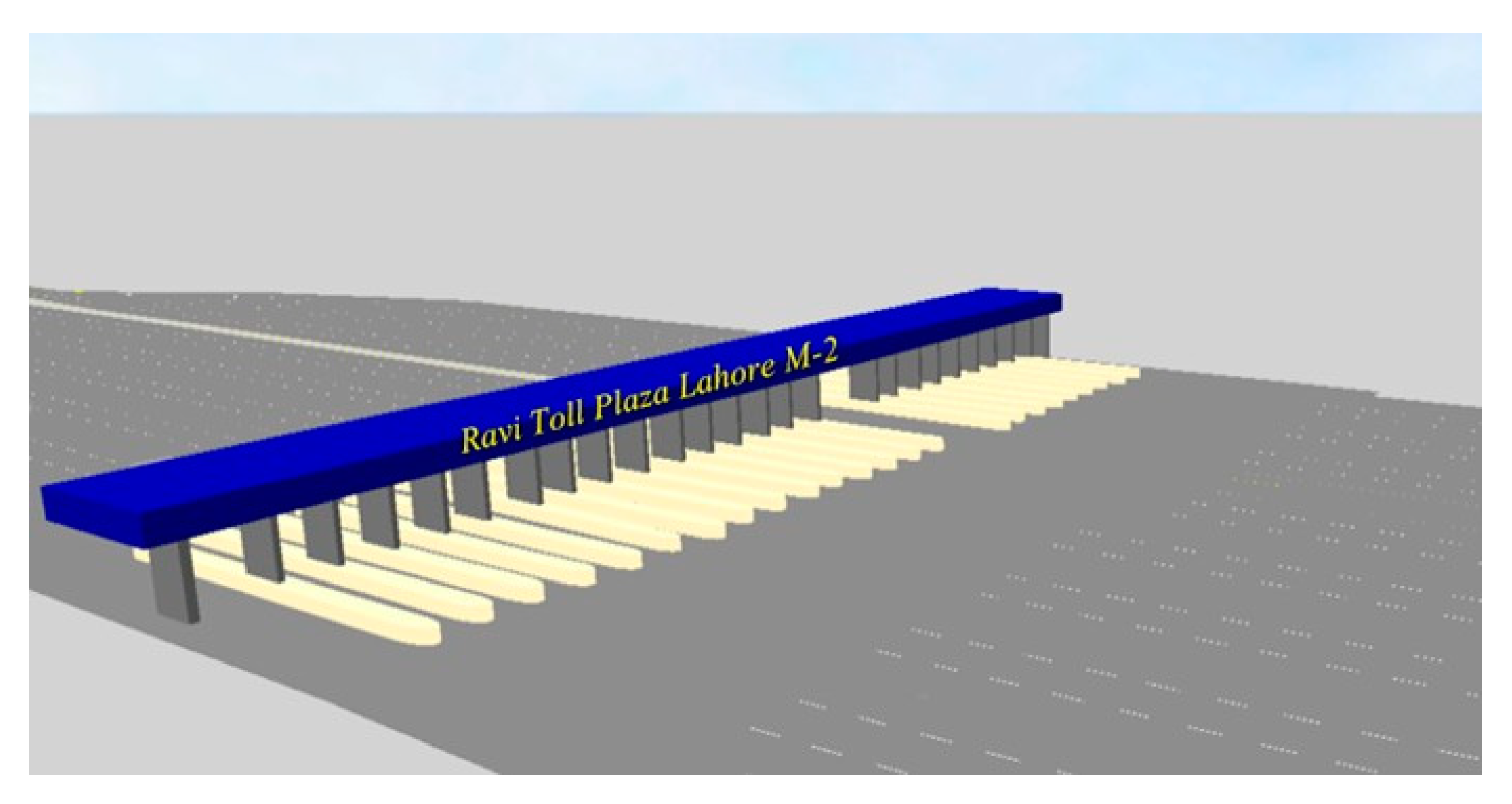
The network was configured such that 60 percent of vehicles used MTC for toll payments, while the remaining 40 percent utilized the ETC payment method. Service times were set at 5 s for ETC and 22 s for MTC. The VISSIMv7 simulation model for Ravi Toll Plaza is shown in 3D in
Figure 10, while a 2D view of toll booths is shown in
Figure 11.
4.4. Model Calibration
Before implementing the control strategy within the VISSIMv7 network, a meticulous calibration of the model’s parameters was conducted. Traffic data collectors were strategically positioned throughout the network to collect essential traffic parameters, including queue length, delays, and vehicle travel time. Furthermore, during the field data collection process using video recordings, actual queue length, delays, and travel time were calculated.
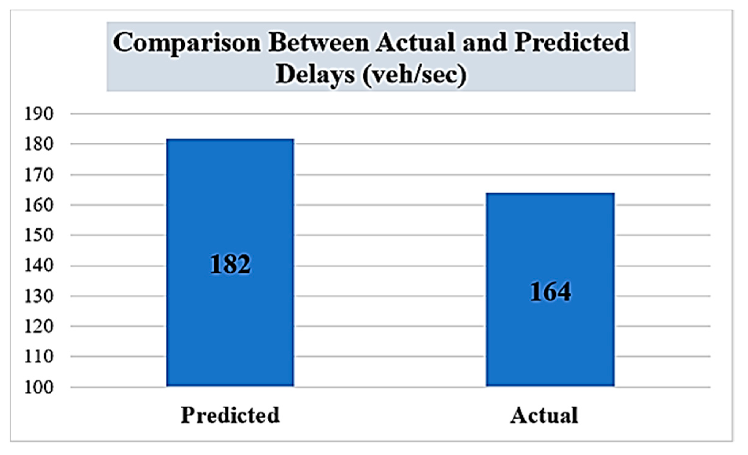
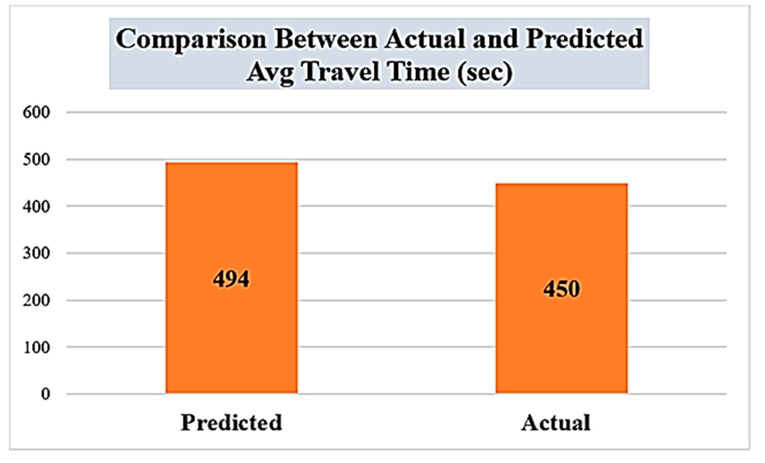
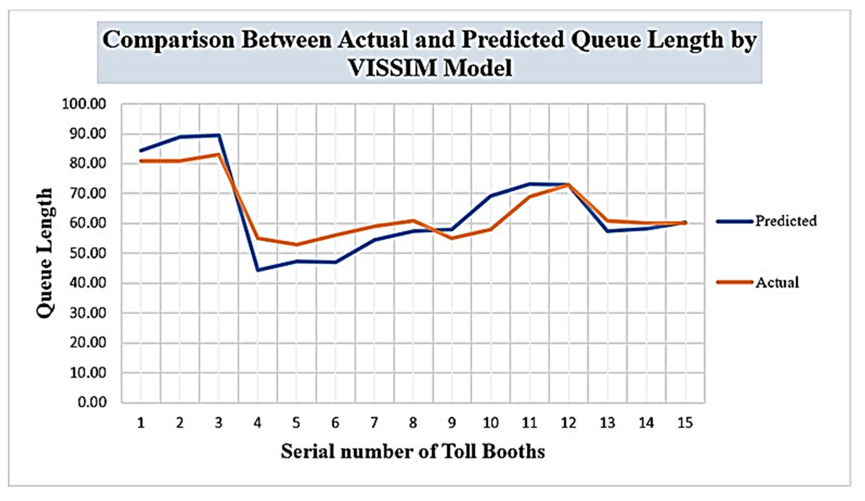
The comparison between the model’s predictions and the field data showed that the model achieved a mean absolute percentage error (MAPE) of 6.5%. This low MAPE value signifies that the calibrated VISSIMv7 model accurately predicted traffic patterns in free-flow and congestion situations, understanding its reliability for proactive control. The delay, vehicle travel time, and queue length profiles presented in
Figure 12,
Figure 13 and
Figure 14 further support the precision of the calibrated VISSIMv7 model.
4.5. Proposed Logic Development Using VisVAPv2.16
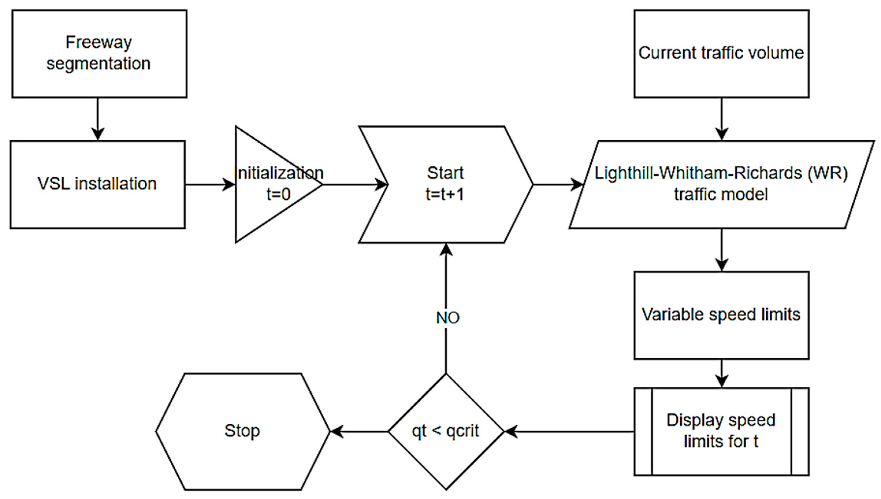
After developing the toll plaza model, the control strategy was programmed using a VisVAPv2.16-based approach on VISSIM. A brief methodology for establishing the control strategy utilized in this research study is shown in
Figure 15. PTV VISSIM annex software, known as VisVAP, was used to develop changes in speed limits and apply ramp metering throughout the simulation.
The development of a program within VisVAPv2.16 was undertaken to facilitate the initiation of the simulation process and optimization of the control variables. This logic was literately executed for each time interval. The current traffic parameters were extracted and passed into the logical program for every interval, generating optimal control inputs. Subsequently, these optimal inputs were returned to the VISSIM environment.
When the current flow changed, the VisVAPv2.16 program replaced the original control parameters with new optimized controls within the VISSIM simulation. Specifically, the program removed the initial limits when the flow exceeded 2500 vehicles per hour. It introduced new desired speed limits of 100 km/h based on the Lighthill–Whitham–Richards (LWR) traffic model, as explained in the methodology. When the flow exceeded 3000 vehicles per hour, the program set a desired speed limit of 80 km/h, and similarly, when it went beyond 3400 vehicles per hour, the program established a desired speed limit of 60 km/h.
Concurrently, the program was designed to monitor whether the ramp metering rate and cycle length exceeded 4 s after each time interval, utilizing the calculation method explained in the methodology.
If the metering rate was below the cycle length of 4 s, the ramp metering signal remained green. However, the ramp metering was triggered when the flow exceeded 3400 vehicles per hour, and the measured occupancy increased, causing the cycle length to exceed 4 s. In short, when the vehicle flow rate surpassed 3400 vehicles per hour, variable speed limits (VSLs) and ramp metering (RM) controls were activated to optimize traffic flow at the toll plaza.
5. Results
The proposed study was conducted at Ravi Toll Plaza, analyzing various control strategy scenarios. The outcomes were evaluated based on four efficiency criteria: queue length, travel time, vehicle delay, and environmental impact. The efficiency of the proposed scenario (VSL + RM) was evaluated by comparing it with three alternative scenarios: the existing scenario, variable speed limits (VSLs) only, and ramp metering (RM) only.
In the VSL-only control scenario, ramp metering was not employed alongside VSLs when vehicle flow exceeded 3400 vehicles per hour. Conversely, only ramp metering was activated in the RM control scenario when the vehicle flow exceeded 3400 vehicles per hour. These scenarios were analyzed and evaluated based on their influence on queue length, travel time, vehicle delay, and environmental factors.
5.1. Traffic Impact Analysis
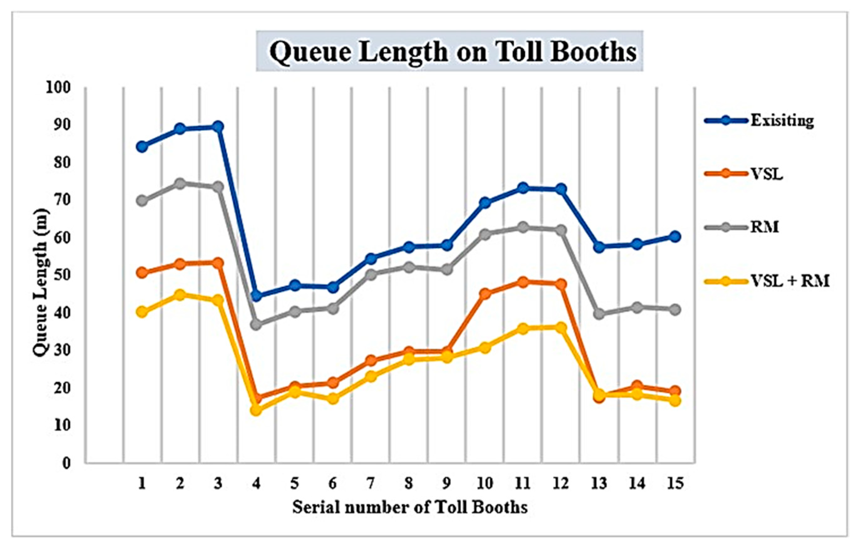
Traffic impact was analyzed based on its influence on queue length, travel time, and vehicle delay in all scenarios. The queue lengths (measured in meters) for all scenarios at toll booths, numbered 1 to 15, are depicted in
Figure 16. The simulation results reveal the scenario’s highest average queue length of 64.18 m. This observation aligns with the real-world experience of long queues forming on weekends during peak hours (04:00–10:00 p.m.) when traffic from Islamabad to Lahore is at its peak. The average queue lengths for the VSL-only and RM-only scenarios were 33.40 m and 53.18 m, respectively.
However, when both controls, VSLs and RM, were jointly operational, an average queue length of 27.60 m was recorded. The average queue lengths are shown in
Figure 17. Average vehicular and stop delays were recorded from the node outcomes. The encompassing node covered the entire network, resulting in recorded vehicle delays that included acceleration and deceleration due to variable speed limits. Recorded stop delays included waiting delays at the ramp when the signal was red and waiting time for service at the toll plaza.
The outcomes showed that the scenario involving the combination of VSLs and RM had average vehicle and stop delays of 95 and 43 s, respectively. In comparison, vehicle delays for the VSL-only, RM-only, and existing scenarios were 125, 148, and 182 s (about 3 min). Stop delays for VSL-only, RM-only, and existing scenarios were 55, 75, and 78 s, as depicted in
Figure 18. These results underscore the traffic impact deduction by the combined VSL–RM strategy.
5.2. Environmental Impact Analysis
Fuel consumption and carbon emissions were analyzed to assess the environmental impact across all scenarios using PTV VISSIMv7 microsimulations. The default VISSIMv7 emission calculation model was utilized to quantify carbon monoxide (CO), volatile organic compound (VOC), and nitrogen oxide (NOx) emissions.
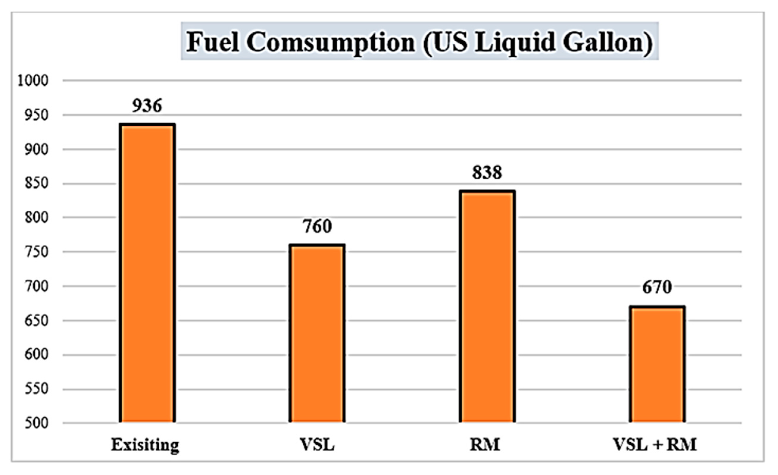
It was observed that the VSL and RM scenarios notably reduced carbon monoxide (CO), volatile organic compound (VOC), and nitrogen oxide (NOx) emissions. Specifically, the VSL–RM scenario demonstrated significant decreases, including a remarkable 28.4% reduction in fuel consumption, lowering from 936 gallons in the existing scenario to 670 in the proposed scenarios, as shown in
Figure 19.
Additionally, CO emissions were reduced by 34.4%, as depicted in
Figure 20, while VOC emissions exhibited a reduction of 32%. The NOx emissions were also reduced by 35%, as illustrated in
Figure 21. These results underscore the substantial environmental benefits of implementing the combined strategy of VSLs and RM.
5.3. Implementation of Proposed Proactive Control Strategy
Developing countries face a significant challenge regarding active transportation strategies due to insufficient public awareness and acceptance. The proposed study tackles this concern by proposing a comprehensive implementation strategy to enhance the successful adoption of proactive control measures. This strategy facilitates governing bodies and law enforcement agencies and benefits users. The deployment of variable message sign boards ahead of the RM and VSL zones was facilitated. These signs offer real-time information about the ongoing queue length, estimated waiting times, and travel durations required to navigate the toll plaza. Such information empowers users to select the proper strategy.
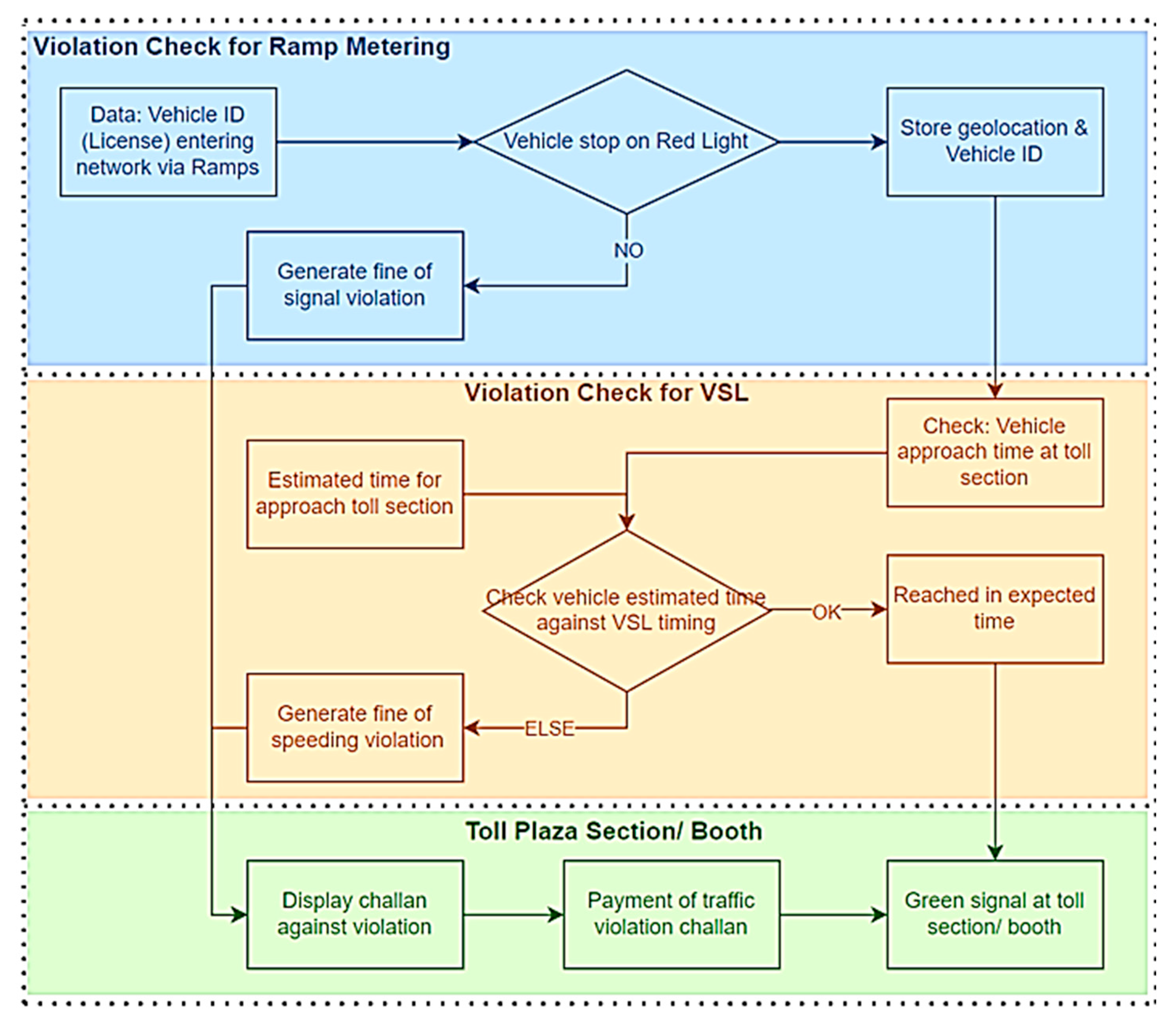
Simultaneously, enforcement agencies have facilitated by the system to identify non-compliant users. A pretrained model designed for signal violation detection is used for this purpose. When a vehicle fails to stop at a red signal during ramp metering, the system captures its ID. The vehicle’s ID is recorded as a traffic signal violator whenever the model detects a violation. Furthermore, when all vehicles enter the VSL zone, their IDs, geolocation, and entry times are recorded. The system also estimates the anticipated time for each vehicle to approach the toll plaza. A vehicle entering the toll plaza before its estimated arrival time could indicate a speed violation (exceeding the speed limit) within the VSL zone. In such instances, the system flags the vehicle as a defaulter.
With a minimal utilization of resources, monitoring would not only be easy, but it would also add value to the treasury, as violations are widespread in developing countries, resulting in the highest accident rate in low- to middle-income countries, according to the WHO [
55]. Upon toll payment, the system generates fines for all defaulters, aligning with their respective violations, whether they are involved in violation of VSLs or RM or both. This study has suggested an obligated acceptable payment and the toll tax is collected as vehicles pass through the toll plaza to enhance transparency and early recovery. The intricate proposal framework for violation detection is outlined in
Figure 22.
6. Discussion
This study achieved robust vehicle detection accuracy of 91%, comparable to or exceeding the performance reported in previous studies, i.e., X. Zhao et al. [
34], and V. Mandal and Y. Adu-Gyamfi [
25]. The proposed LSTM model for short-term flow prediction demonstrated superior accuracy to models presented in Y. Han et al. [
44,
45]. Additionally, the proactive control strategy proposed in this study resulted in substantial improvements in traffic management, including a 57% reduction in queue length. After that, vehicle delays were reduced by around 47%. It stopped delays by 44.8%, surpassing the efficiency of recent studies with similar proactive strategies applied by N. Yuan et al. [
50], A. D. Spiliopoulou et al. [
48], and M. Papageorgiou et al. [
49].
Furthermore, the VSL–RM scenario achieved a 28.4% decline in fuel consumption and a 34% reduction in air pollutant emissions, highlighting the importance of integrated and proactive traffic control strategies in mitigating environmental impacts, enhancing air quality, and fostering a sustainable transportation system. The detailed implementation strategy presented in this study further enhances its robustness and practical applicability in real-world traffic management scenarios.
Despite its potential, the proposed strategy for alleviating congestion at toll plazas has notable limitations that should be addressed in future research endeavors. The reliance on a simplified vehicle classification system may restrict the accuracy of real-time arrival rate calculations, impacting the strategy’s overall effectiveness. Additionally, while the prediction framework leverages existing traffic models, integrating more advanced models like the cell transmission model (CTM) could improve prediction accuracy and enhance traffic management strategies.
Refining the training of the long short-term memory (LSTM) model with factors such as seasonal patterns and public holidays is also essential to improve its performance under diverse traffic conditions. Exploring synergies with autonomous vehicle systems and connected environments would unlock additional opportunities to optimize traffic flow and coordination, maximizing the strategy’s impact on congestion alleviation and sustainable transportation systems.
