Article

A Newly Discovered Ethnocultural Substrate along the Atlantic Façade—Evidence for the Unique Counting System and Mathematical Strategies Shared by the Basque Country (Euskal Herria), Spain, France, Ireland and Scotland

Department of Spanish and Portuguese, University of Iowa, Iowa City, IA 52245, USA
Histories 2022, 2(2), 112-145; https://doi.org/10.3390/histories2020010
Submission received: 12 November 2021 / Revised: 6 December 2021 / Accepted: 15 April 2022 / Published: 29 April 2022
(This article belongs to the Section Cultural History)

Abstract

:
Until now, the pre-decimal metric units of linear measure employed traditionally in the Basque Country have not been compared to similar ones documented for Celtic-speaking zones of the Atlantic façade. These base units are distinctive in that they are septenary in nature, consisting of units of seven and its multiples. In this study, the remarkable similarities that characterize these traditional linear measures are analyzed and subjected to scrutiny. The investigation also examines the mathematical strategies that were involved in laying out land holdings. The measuring devices traditionally employed are also discussed, as well as the ways in which the septenary units acted to structure sociocultural, political and administrative practices. The implications that can be drawn from the wide geographical reach of the system are explored, along with the time-depth that should be assigned to the system as a whole.

1. Introduction: The Septenary Package

In this investigation, the term Septenary Package is used to refer to a pre-decimal metric metrological system characterized by septenary units of measure as well as the material and immaterial instantiations of these units, including the way they were manipulated and integrated into social practice. As such, memory traces of these units point to a type of long-term landscape inhabitation (Chadwick and Gibson 2013), guided by cognitive supports and affordances intrinsic to the Septenary Package. More specifically, we are talking about an ethnocultural complex that assigned numerical importance to septenary units of measurement, units consisting of seven subunits or multiples of seven, and consequently to the use of measuring devices such as a 7 ft. staff or rod and a 21 ft. pole. The unit associated with the latter instrument was known as a perche. In the Basque region, these poles were supplemented by another measuring device, a special rope woven so that there were two types of colored markers woven into it, one color marking every seven feet and another every 49 ft. The latter 49 ft. unit is called a gorapila, a term that translates as ‘knot’ (Frank 2008b). Taken collectively, these units were conceptual devices that allowed users to configure the landscape in a distinctive fashion.
While the use of septenary units of measurement is particularly well documented in Euskal Herria (the Basque Country), there is evidence that similar septenary units were employed along the Atlantic façade, suggesting a continuity of metrological practice and more particularly, the association of the Septenary Package with agro-pastoral practices (Frank 2017). In Euskal Herria, these septenary units of measure form an integral part of pastoral sociocultural practices that comprise the Basque saroi. These are circular sites laid out on the ground and organized around a center stone, often with eight uprights on the perimeter aligned to the cardinal and intercardinal directions. As will be demonstrated, units based on seven and its multiples also structured the laying out of landholdings along the Atlantic façade, for example, the old Irish acre and even the Bailebiatagh or “townland”. Also discussed, is the way that the Scottish Gaelic title Toiseach, along with the Irish Gaelic term Taoiseach, may fit into this same cultural complex and once formed an integral part of it. The geographic reach of these septenary units of linear measure underscores the potential longevity of related metrological practices in this zone and their role in social memory. As Bloch observed back in 1934, using Durkeim’s terminology, the persistence of measures is closely bound up with the questions of communal memory (mémoire collectif) (Bloch 1934, p. 280).
That elements from the Septenary Package have survived not only in the Basque Country but also along the Atlantic façade raises a question: is their survival an indication of the age that should be assigned to the Septenary Package? Could they be traces of relatively early efforts to cognitively configure the landscape? When highly distinctive units belonging to a well-structured metrological system are encountered in contiguous geographical locations, this often implies the existence of a type of metrological Sprachbund. This is a zone in which social collectives are dependent on a particular system of communication that permits the recording, storing and sharing of information in a consistent and meaningful fashion. In short, the employment of a unified system of metrology involves a tacit agreement on the part of its users, much in the same way that a common language does, and hence confers significant communicative advantages and other benefits to the social groups involved (Kula 1986).
In sum, the term Septenary Package used in this investigation is intended to bring together interrelated intangible and tangible artifacts into a single distributed cognitive system. Thus, the approach utilized to analyze this data is one that subscribes to a broad socioculturally situated view of the component parts of the cultural complex in question (Frank 2008a). As a result, the approach affords a means of studying the evolution of discrete elements of the overall cultural complex across time, tracing given lineages of cognitive and material artifacts, e.g., lineages understood as specific septenary units of measurement. In short, the expression Septenary Package is an umbrella term that provides a way to gain purchase on this cultural matrix and to understand it as a whole, that is, as a set of interlocking elements, composed of septenary unit types, measuring devices and their applications in social practice. Portraying the component parts as representing a nexus of tangible and intangible elements will allow us to see how the different parts relate to each other and to assess their persistence across time. This approach also will permit us to detect the modifications and permutations that the units have undergone.
The present investigation is divided into four major sections which in turn are organized around the following working hypothesis: that the ethnocultural substrate to which the Basque septenary units of measurement belong, once extended far beyond the narrow confines of the Basque Country itself. To test the validity of this hypothesis, first, we will discuss several identical septenary units of measure employed in the Iberian Peninsula prior to the imposition of the decimal metric system in the 19th century. Next, evidence for the use of septenary unit types along the Atlantic façade will be brought forward. In the third major section, evidence for the use of a linguistic vigesimal counting system in this same geographical zone will be examined as it is documented in Celtic languages, French, and in Basque (Euskara). That section concludes with a discussion of the relevance of these vigesimal features to the question of the geographical range of the septenary units of measure, and more broadly, to the question of the time-depth that should be assigned to the Septenary Package itself. The final section explores the possible connections between the term Toiseach/Taoiseach, mentioned earlier, and the septenary units of measure discussed in this study.
Once all the evidence is laid out, the commonalities that come into view will allow for further study of the sociocultural embeddedness of the metrological system under consideration. Stated differently, when one encounters uniformity in metrological practices and the use of the same unit types of measurement, this situation can be interpreted in two ways.
(1)
It can be the result of a top-down vertical imposition of a system by a highly structured scientific elite, e.g., as occurred in the 19th and 20th centuries in the case of the decimal metric system which involved the imposition of a system from above. This is a process that, by necessity, must bring into play complex mechanisms for transmitting information about the new system to the populace in question and convincing them to use it. It requires vehicles for communicating with the intended audience, populations that were sometimes but not always literate. This required providing them with basic information about the new system and how to use it, along with finding ways to ensure that they adopted it. In the case of the invention and introduction of the decimal metric system, this was done in a cultural setting already equipped with a scientific elite and a literate body of experts at the top.
(2)
In contrast, in pre-literate societies that were living in orality, the acceptance and maintenance of a distinctive metrological system tends to be the result of horizontal processes of face-to-face social contact and exchanges. These are often the tangible result of commercial and social exchanges between the collectives in question. Therefore, with respect to the septenary mensuration system, one of the many questions that remain without a solution is the following: is it possible to reconstruct the cognitive strategies that informed the use of these septenary units of measurement? In other words, can we identify specific instances where the populations of this zone employed these septenary units to structure the space around them? And, if we can do so, does the resulting evidence allow us to determine the time-depth that should be assigned to the system, and figure out where it might have originated and/or how it was transmitted across time and space? All these questions warrant attention, even though their answers are still far from clear. Even so, they will help guide us in our exploration of these septenary units of measure and how they were instantiated in social practice across the Atlantic façade.

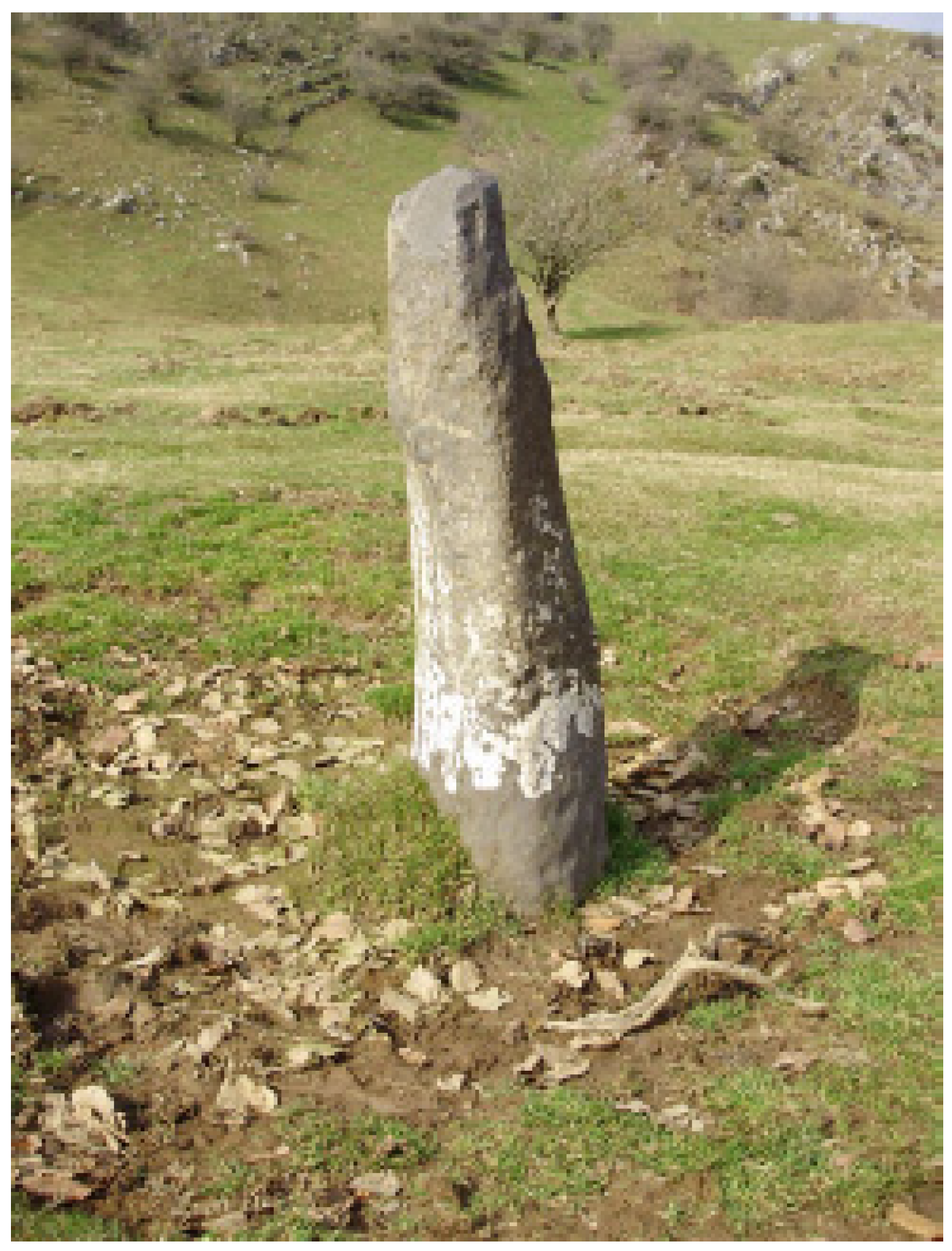
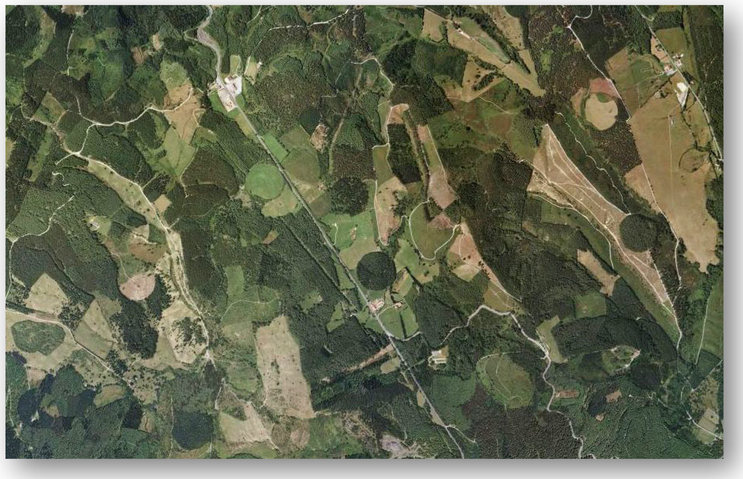
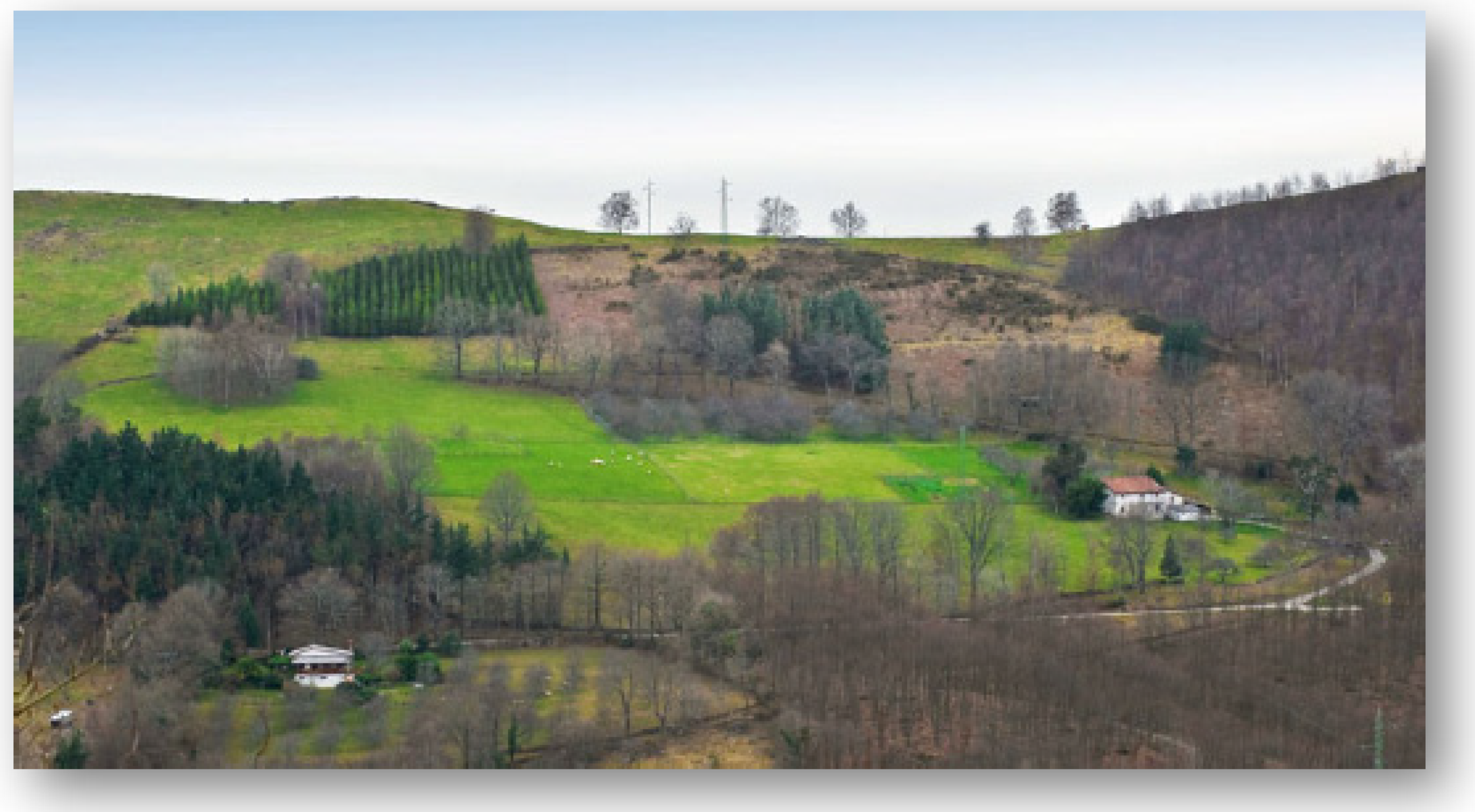
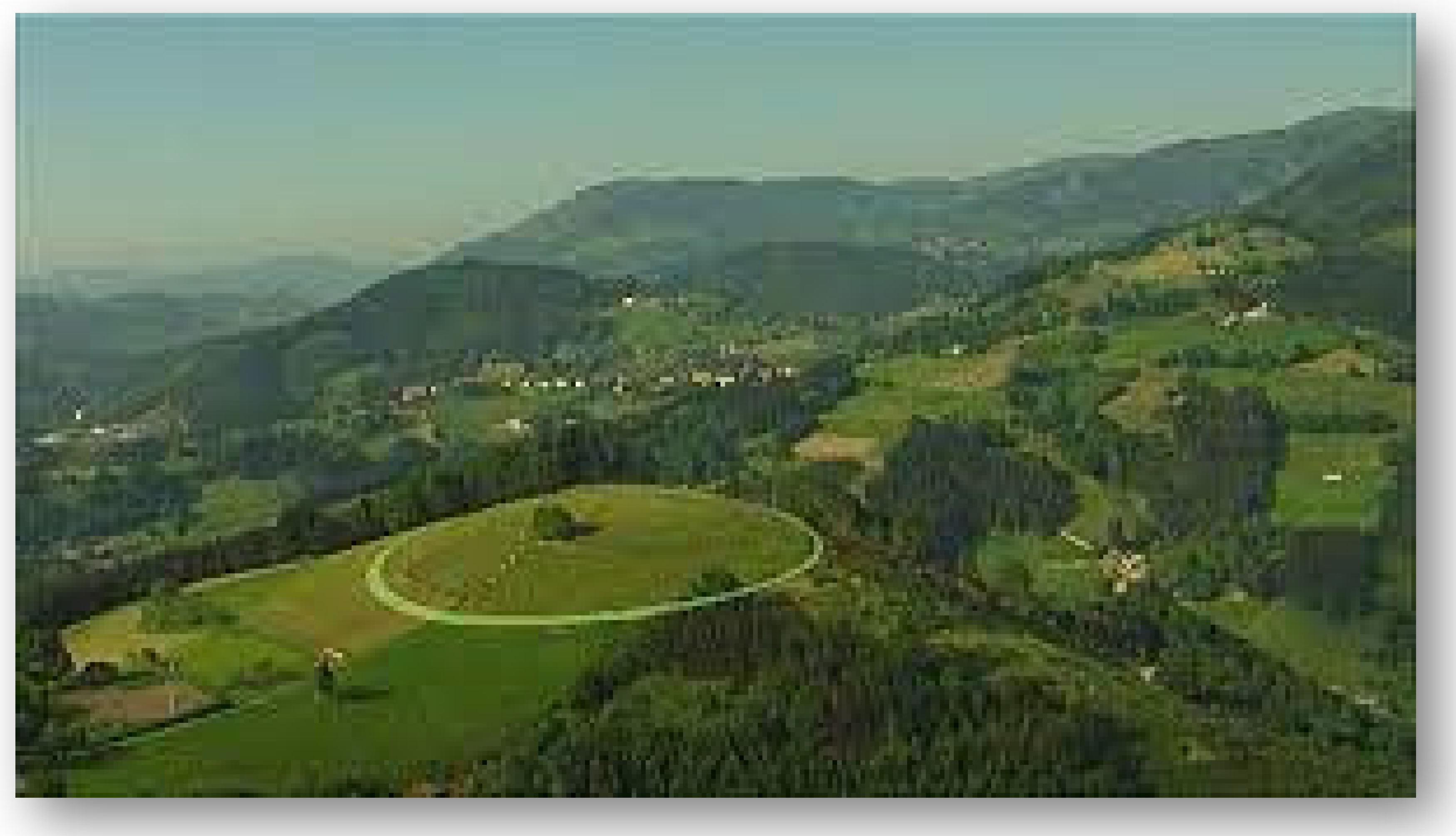
1.1. The Grounding of the Septenary Units in Euskal Herria

Over the past twenty years, extensive research carried out in the Basque Country has revealed the way that pre-decimal metric septenary units of measure were widely employed to lay out land holdings, that is, until the imposition and acceptance of decimal metric units of measure (Ariznabarreta Zubero et al. 1998; Frank and Patrick 1993; Rementeria Arruza and Quintana Peña 2010; Zaldua Etxabe 1996, 2006, 2010, 2014). In fact, in many locations, these pre-decimal metric septenary units continued to be used well into the 20th century by Basque farmers to lay out their land holdings. Much of the research on these units of measure has been carried out in conjunction with in-depth studies of the saroiak, called ‘seles’ in Spanish. Furthermore, it was my own research into these sites and how they were laid out that first introduced me to the use of the septenary units of linear measures. The saroiak are large circular configurations marked off usually by eight upright stones on the perimeter, oriented to the cardinal and intercardinal directions, although sometimes only four boundary stones are found. In a few cases, up to sixteen boundary uprights have been encountered. These outer stone markers were set at legally prescribed distances from the center stone (Frank 2016). Each saroi is further distinguished by having its own name (Figure 1).
Although over time many of the center stones were replaced with more modern ones, there are examples of older ones (Figure 2).
To date, around a thousand of these sites have been identified, many of which show up as lighter and darker colored circular configurations on areal maps such as the one below (Figure 3):
Initially, the stone circle landholdings were incised in the common lands. They were administered by members of the local community and governed by decisions of the batzarra ‘town council’ (Frank 2019; Zabalza Seguín 2004). The stone circles were held in usufruct by those who had rights to the commons and, by extension, the right to pasture cows, pigs and sheep on these lands during the daytime hours. However, they had to bring the animals back into the confines of the stone circle at night, the space in which the huts of the herders and the corrals for the animals were located. This arrangement allowed the animals to be corralled and, therefore, kept safe at night from predators.
As time passed, many of these stone circle lands fell into the hands of monasteries and local elites. They were inherited, donated, bought and sold, passing from one owner to another. However, in the process, they kept their legal status and were understood as transfers of property. In addition, many of them ended up being converted into farmsteads (Gogeascoechea Arrien et al. 2009, 2011; Rementeria Arruza and Quintana Peña 2010).
Whereas the saroiak are often located on southern facing slopes, such as in the case of Akola (Figure 4), they are found in a wide variety of locations, such as the hill site below (Figure 5).
In this instance, the unobstructed 360-degree view of the surrounding landscape, as well as the skyscape, would have allowed the cardinal and intercardinal directions set out by the perimeter stones to be particularly useful in orientating the viewer.

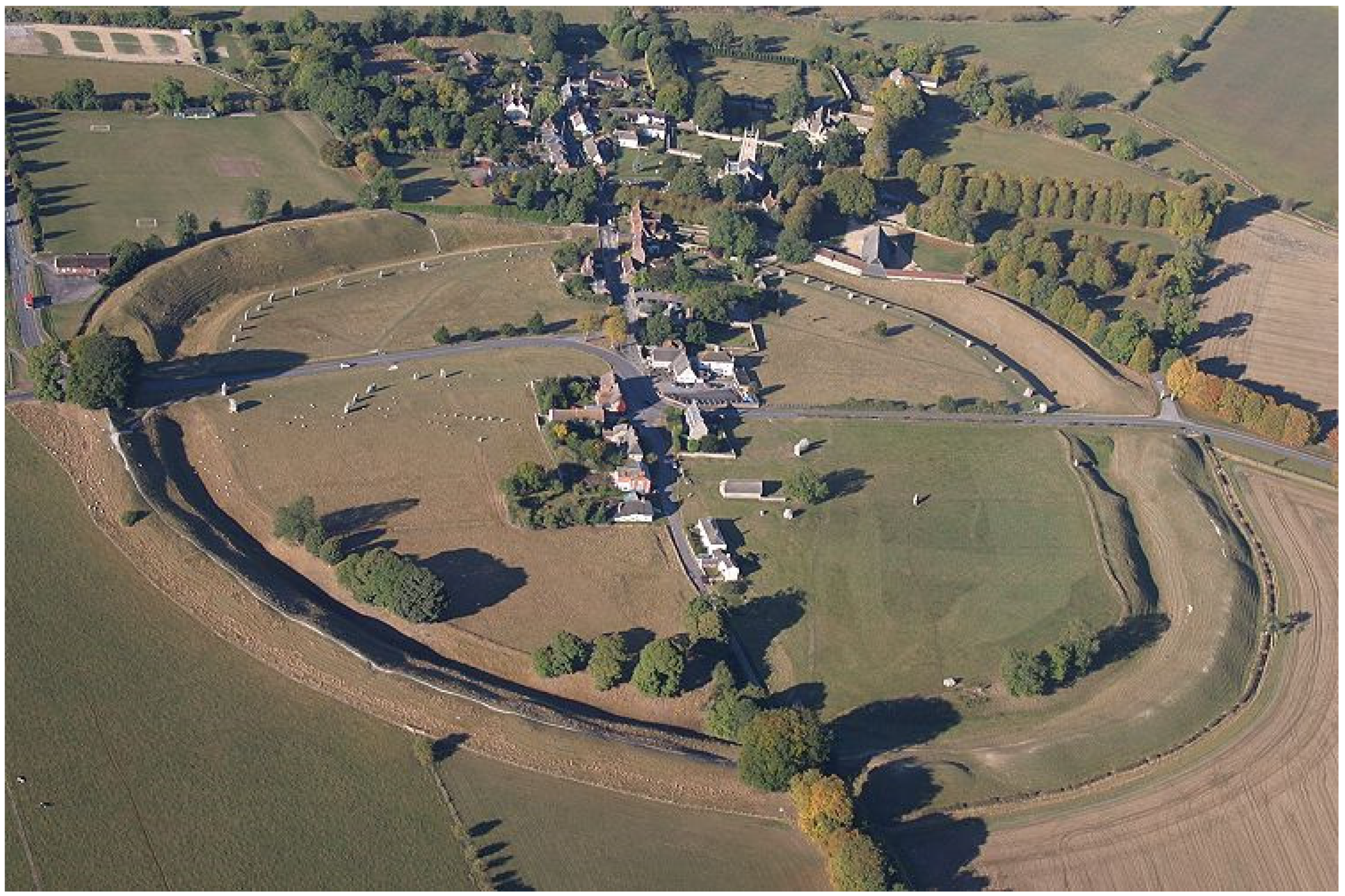
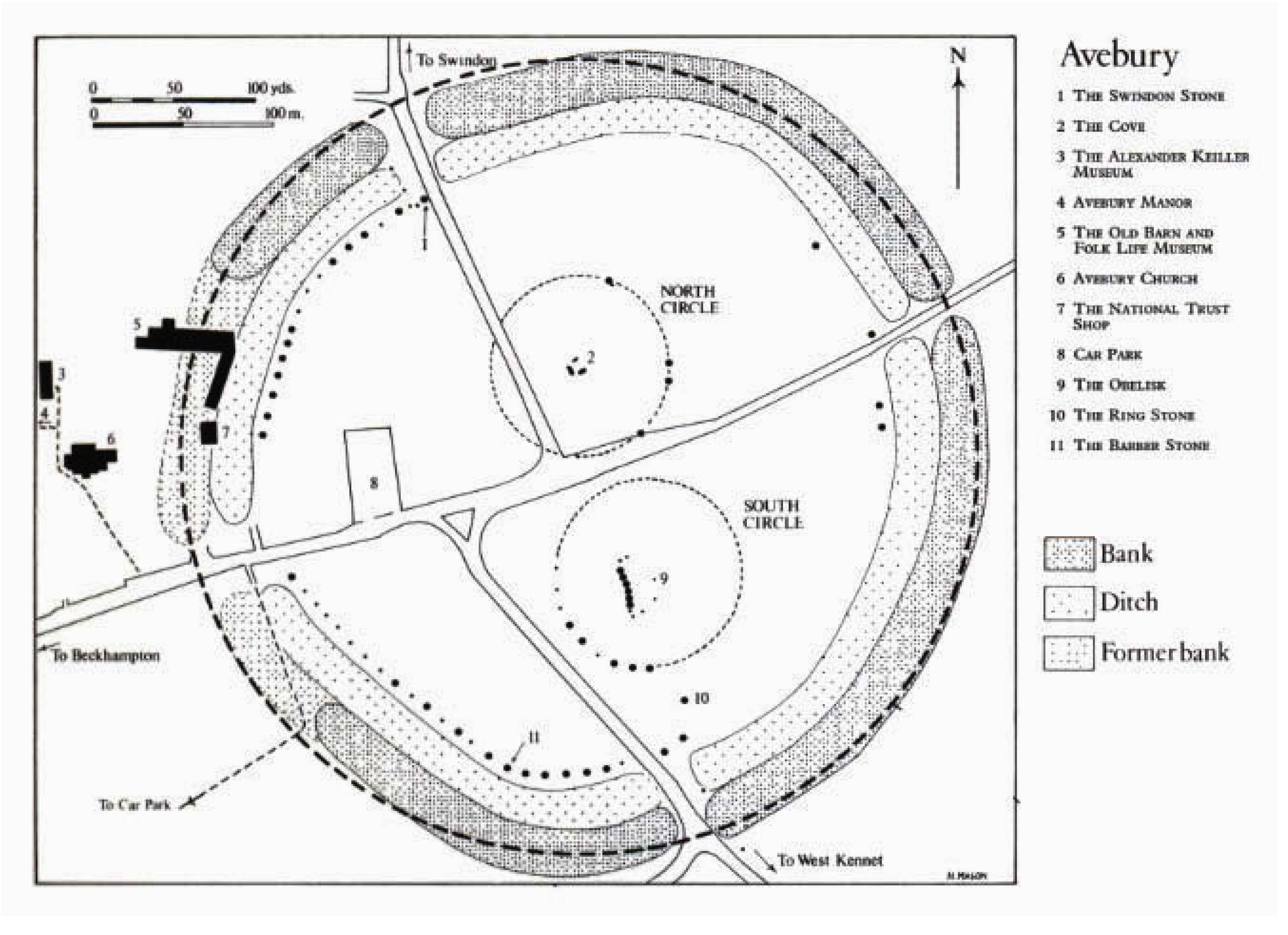
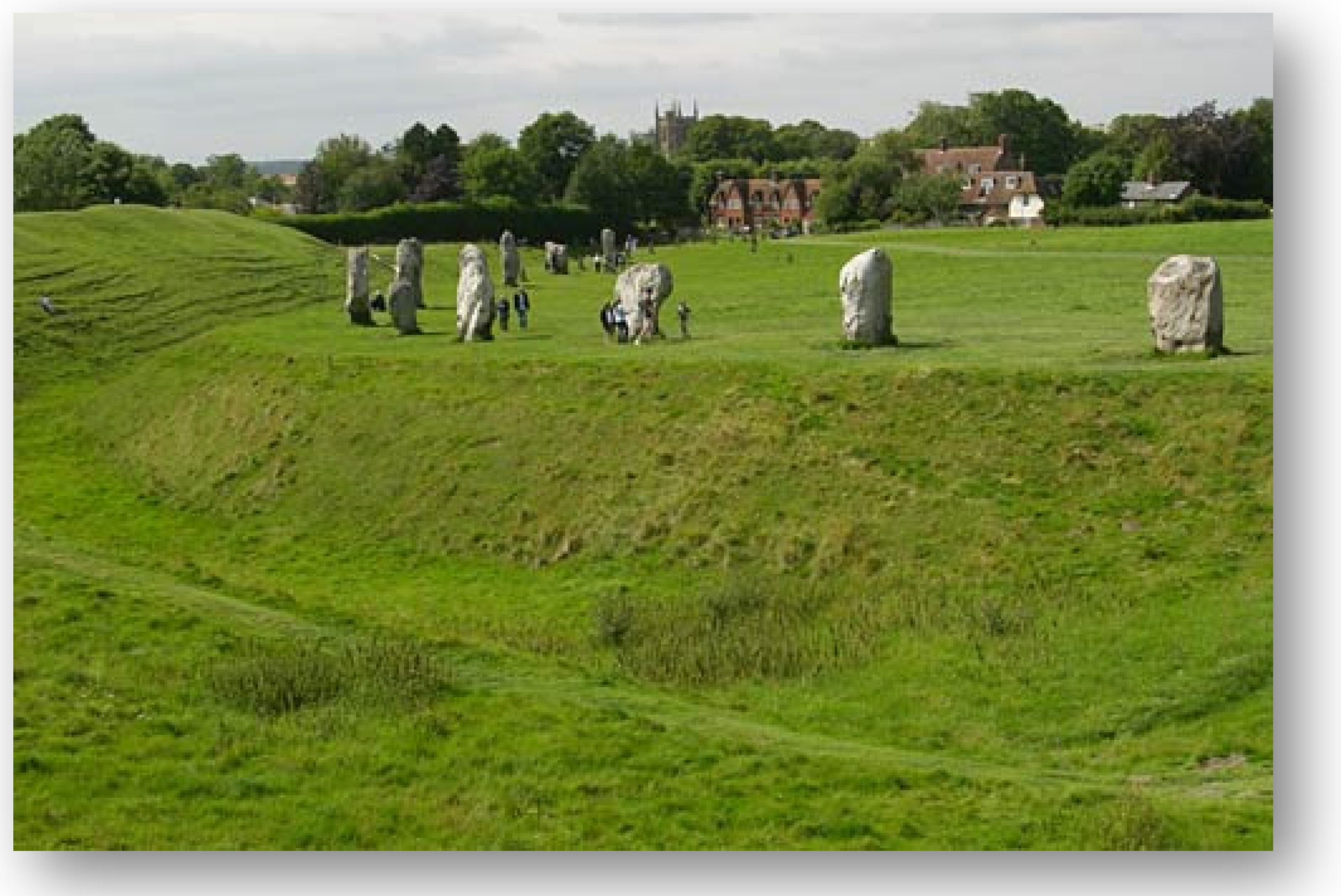
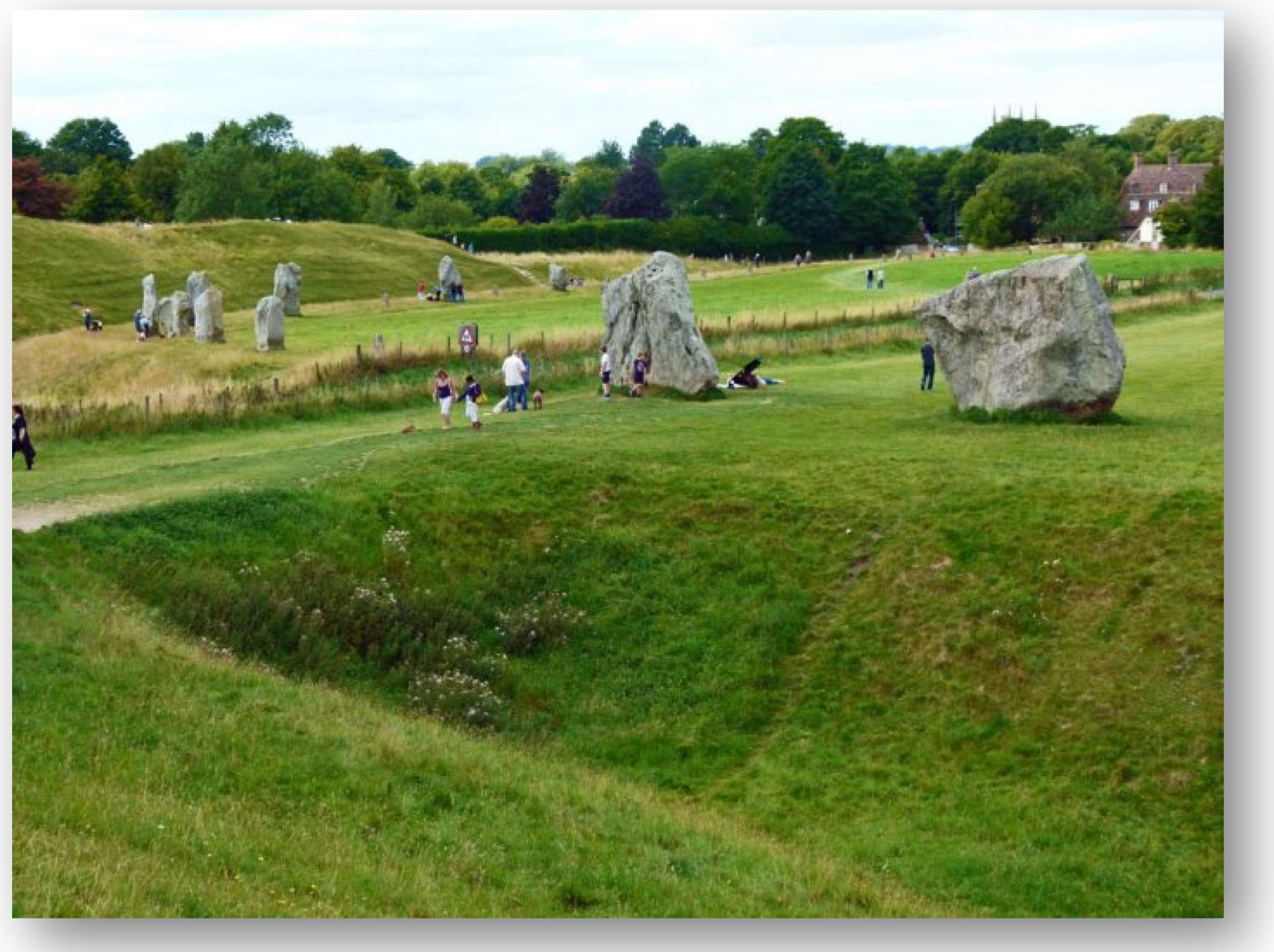
1.2. Comparing the Standard Saroi and Avebury

Although not visible today, traditionally the saroiak were set off from the rest of the land by a fosse, called lubakia (from lur-ebaki ‘ground cutting’), that was excavated around the circular site itself. When viewed from the air, the size of the sites can be misleading, appearing smaller than they really are. For comparison, the radius of the standard saroi or ‘sel comun’ of Gipuzkoa is remarkably close to that of the renowned stone circle of Avebury, the largest henge structure in Britain. The radius of the standard Basque stone circle is set at 588 ft., each foot being calculated at 0.28 m, which gives a radius of 164.64 m (Zaldua Etxabe 2006, p. 112). That radius, set out as 12 gorapila (12 × 49 = 588), was measured using a rope with gorapila knots in it. By comparison, Alexander Thom’s estimate for the radius of Avebury is 165.8 m, an estimate that continues to circulate (Thom 1967, pp. 89–91). Keeping in mind that the inner circle at the Avebury site itself does not form a perfect circle, defining its radius with absolute precision is difficult, if not impossible (Figure 6, Figure 7, Figure 8 and Figure 9). In the case of the Basque stone circles, in actual practice, when they were laid out on the ground, small deviations from the legally stipulated radius can be detected.
Thom’s estimate of the radius of the main ring of Avebury was based on his belief that the builders were attempting to achieve a radius of precisely 200 megalithic yards, a unit which Thom set at 2.72 English feet, that is, 0.834 m. Thom’s conclusion reflects his assumption that the builders of Avebury were privileging decimality.

1.3. Other Considerations Concerning the Septenary Units of Measure Used to Lay Out the Saroi Stone Circle Sites

Work carried out previously, on these Basque saroi sites, has consisted of investigations focused almost exclusively on recording how they were constructed and utilized in social practice inside Euskal Herria itself. In contrast, what concerns us in the current study is the documentation of the use of septenary units of land measure along the Atlantic façade, units similar if not identical to those recorded in the Basque Country. More specifically, what will be examined in this study is the nature of the relationship between the types of metrological practice in both locations, that is, inside Euskal Herria and along the Atlantic façade. Until now, little attention has been paid to the possibility that the septenary units of linear measure typical of the Basque materials once formed part of a larger, more geographically widespread system. In other words, until now, evidence has not been collected nor analyzed for the utilization of the septenary units of measurement and their sociocultural instantiation in social practice in zones reaching beyond the limits of the historically attested Basque-speaking region.
At the same time, we need to keep in mind that the mensuration system utilized in the architectural design of the Basque stone circles directly integrated these septenary unit types. Moreover, results from carbon-14 dating at several of these sites suggest that the design itself, along with the septenary units of measure, was already in place by the beginning of the Christian era, if not earlier (Zaldua Etxabe 2014). However, the archaeological results do not allow us to determine when the architectural design itself came into being, the terminus ante quem non, rather only that it was already in existence at this early date. The widespread distribution of these septenary unit types in the rest of the Atlantic façade suggests that they may date back to the Iron Age and pre-Roman social practices and that their origins may reflect even earlier metrological traditions.
Although often overlaid by non-septenary frames of reference, the septenary unit types are still visible across the Atlantic façade. Hence, the first step is to retrieve—to the best of our ability—the various types of septenary units that made up the earlier metrological system in question. Next, in analyzing these units and their cultural embeddedness in social practice, we need to be clear about the fact that we are developing a model of the way these practices might have been conceptualized, a hypothetical reconstruction of what the system might have looked like. This reconstruction includes references to the possible cognitive strategies that once informed it and the kinds of mathematical understandings and operations that might have characterized it.
By enlarging the geographical reach of the study to include the rest of the Atlantic façade, we will be able to identify other septenary unit types linked to concrete social practices and begin to develop a model of the organizational structures that undergirded the system. Moreover, the way that these unit types were embedded in the social practices of the populations in question, allows us to broaden the scope of our understanding of the septenary system and ultimately gain access to the conceptual frames of reference that structured the use of these units, albeit in a hypothetical fashion.
At this stage in the research, the evidence analyzed reveals a surprising degree of continuity not only across this geographical zone but also continuity across time, all of which suggests that the septenary units of measure form part of an ethnocultural substrate. Rather than being viewed in isolation, merely as vestiges of a metrological system, these septenary features need to be contextualized and their sociocultural implications investigated. In sum, taken collectively, these units of measure, along with the social practices once associated with them, constitute the Septenary Package, an entity whose ultimate time-depth and geographical extension has not yet been determined. The units of measurement are amply documented in the historical record starting in the early Middle Ages, although other types of evidence take us back to the Iron Age. Moreover, as will be shown, there are reasons to believe the septenary units might be even older and that the geographical extension of their use encompassed a larger area, stretching beyond the Atlantic façade (Frank 2017).

2. Agrarian Surface Measures along the Atlantic Façade

As we will soon see, the septenary units of surface measurements are not limited to the Iberian Peninsula. Indeed, they are embedded in social practices documented in other locations all along the Atlantic façade, north to France, and across the channel into Ireland and Scotland. Nonetheless, we will begin our review of these units by examining their counterparts in the Iberian Peninsula.

2.1. The Basque Gizalan Compared to the Castilian Peonada

As noted, septenary units of measure belonging to the Septenary Package are documented in zones outside the borders traditionally assigned to the historical Basque-speaking region. For instance, starting with the geographical regions nearest to this zone, we find that there is a unit of land measure found in Castile, a zone just to the south, that was in use during the Middle Ages and even later. That unit is called the peonada. The unit is identical to a unit known as the gizalan in Euskara, which measures 4900 square feet or 380.4 square meters. Well into the latter half of the 20th century, Basque farmers were still laying out land in gizalan, usually in plots 70 × 70 ft. square. By comparison, the unit of surface measure called a peonada corresponds to exactly 380.4 square meters (Frank 2008b)1. Although the use of the peonada extended beyond Castilla y León and is found in other regions of the Iberian Peninsula, the geographical spread may be due to the political influence of Castilla y León in historical times.
In any case, what is obvious is that the official peonada of Castile is a carbon copy of the Basque gizalan. However, it is a conceptually eroded copy since, in the case of the peonada, there is no longer any recognition of the underlying septenary units that gave rise to it. This suggests that the Basque gizalan is linked to similar measures found in the north of the Iberian Peninsula, regardless of the political influence that the Kingdom of Castile and Leon had in later times. The difference lies in the fact that over time, those who employed the peonada lost track of the connection that it formerly had to the septenary metrological system. Today, the surface area comprised by the peonada is simply expressed in meters (which, as mentioned, assigns to it an area of 380.4 square meters) with no reference to any septenary element. In short, it is no longer recognized as a septenary unit of measure.
Even though the septenary conceptual and mathematical underpinning of the unit has been lost in Castile, the fact that these two units of measurement are identical in terms of the surface area they cover is evidence that in times past the system of septenary measures extended beyond the borders of what is today Euskal Herria. Nevertheless, because the zone in which the peonada was utilized is a region adjacent to the Basque region, it is difficult to use the example of this particular unit to assess the time-depth that ought to be assigned to the Septenary Package itself. That said, the identity of the two units does take us back at least to the Middle Ages, given that the term peonada already appears in El Cantar del Mío Cid, the oldest epic poem in the Castilian language, probably written around 1200.2
To summarize, in the Basque Country, a common septenary unit of surface land measure has been the gizalan which translates as ‘man-work’. As we have seen, this Basque septenary unit is identical in size to the Castilian unit called peonada in Spanish. That term is translated as the work of a ‘peon’ or day-laborer. Indeed, in Castile, a zone located just to the south of the Basque region, the use of this same unit of measurement was very widespread. It was commonly used to lay out land holdings as well as to calculate work obligations, rewards and punishments during the Middle Ages and beyond. In Catalunya, further to the east, it is still employed in real estate advertisements, but again with no awareness of the underlying septenary nature of the unit itself. The septenary basis of this land measure survived in the Basque Country into the late 20th century and is still recognized today. In contrast, in Castile, the unit’s septenary origins became obscured at some point in the past, although there is no way to determine when this happened. In other words, there is every reason to believe that in times past, the unit of 4900 sq. ft. played a key role in the daily lives of the people living in this zone.

2.2. Survival of the 7 ft. Unit of Measurement along the Atlantic Façade

To bring into a clearer focus the time-depth that might be assigned to the Septenary Package as well as the way in which units from it have evolved, we will move on to discuss the use and geographical diffusion of another key septenary unit of measurement. In Euskal Herria, this 7 ft. unit was and is called a gizabete, which translates as ‘full-man’ or ‘whole-man.’ It consisted of a pre-measured rod or staff, often carried by shepherds while tending their flocks as well as by officials. In the rest of the Iberian Peninsula, a unit set at the same length, i.e., 7 ft., went by the following names: estado, brazada and braza (Martínez Gómez [1795] 1816). As for the ‘feet’ in question, they are defined as ‘common feet of Castile’ and measured 0.278 m, based on the feet of the vara de Burgos. In 1568, the latter was declared the official bar standard of Spain and all of the Spanish Empire (Bowman 1961, p. 17). That bar standard is identical in length to the one used in Castile and the two Basque provinces of Gipuzkoa and Bizkaia (Frank 1999b).
In France, we find another standard unit of measure that once formed part of the Septenary Package. The unit in question is known as a toise in French. Its length corresponds exactly to that of the gizabete: it was equal to ‘7 common feet of Castile’ (Leizaola 1977, p. 125; Villarreal de Berriz [1736] 1973, pp. 116–17; Zupko 1978, pp. 175–76). Although much has been written about the toise unit itself (Saigey 1834, pp. 109–12; Strasser 1975), this correspondence has gone relatively unnoticed. Consequently, the underlying septenary nature of the unit has not been taken into consideration. Whereas the toise bar standard is regularly defined as being composed of six pieds de roi or pieds-de-Paris, when examined through the lens of the Septenary Package we find a 7:6 ratio holding between the ‘feet’ of the Basque gizabete and those of the French toise. That is, both standards are defined as equivalent to 1.949 m. Moreover, the terms used to refer to the ‘feet’ of the toise standard, namely, pieds de roi and pieds de Paris, suggest that a recalibration of their length took place in the early Middle Ages, probably in a top-down fashion by means of a royal decree (Bloch 1934, pp. 280–82; Navel 1932). At the same time, even though these ‘royal feet’, equivalent to 0.324 m today, were officially recognized, in practice the locals on the ground probably continued to use ‘common feet’ of 0.278 m.3
According to histories of French land measures, these royal feet were part of the reforms introduced by Charlemagne in the year 790 CE. These reforms included the toise unit being set at ‘6 royal feet’. At that time and even later, feet of various lengths were in use in France. While we do not know the exact physical length assigned to the feet of the toise at the end of the 8th century, supposedly “the toise originally represented the distance between the fingertips of a man with outstretched arms” (Rowlett 2013, p. 373). That assumption, however, appears to be contradicted by the fact that in the 19th century when the decimal metric system was invented, six of these royal feet were assigned a precise value of 1.949 m (Rowlett 2013, pp. 285, 373).
According to Saigey, it is not clear what motivated Charlemagne to assign six pieds de roi to the toise unit (Saigey 1834, pp. 119–10). One possibility is that the toise unit was already in existence and there was a desire for some reason to divide it into six parts rather than seven. Another possibility is that by the time of Charlemagne even though the bar standard was widely in use, the fact that it had regularly been divided into seven parts had been lost, at least to members of the elite, i.e., those in Charlemagne’s inner circle. Nonetheless, the assignment of six pieds de roi to the toise standard by Charlemagne’s time allows us to see that the standard itself was already in use in the 8th century.
Whereas much has been written on the vicissitudes of the toise bar standard in recent centuries, particularly the key role it played in the development of the decimal metric system, the genealogy of the toise itself and its linkage to the Septenary Package has not caught the attention of researchers.4 Nevertheless, in the 18th century, the 7:6 ratio holding between the two standards was common knowledge and is well documented in the historical record. For instance, the Basque surveyor, architect and engineer Villarreal de Berriz stated the following in his report dating from 1736: “In a case I have a royal foot of Paris, done in bronze, extraordinarily precise and having measured it and compared it many times with the foot of Castile, I find that 6 feet of Paris, which is the toise, are equal to precisely 7 feet of Castile” (Villarreal de Berriz [1736] 1973, pp. 116–17).5
In short, the geographical extent of the 7 ft. unit is significant. We find that in Euskal Herria, the unit known as a gizabete has its equivalent in the rest of the Iberian Peninsula, i.e., where it is called estado, brazada and braza. At times, the term toesa was used in Spanish to refer to the same 7 ft. unit, that is, as a translation of the French word toise. Also, it is important to keep in mind that the toise was the official pre-decimal metric standard of France. Moreover, by the middle of the 18th century, it was functioning as the linear measure most commonly employed by the royal armies and navies as well as in mathematical works in Spain, Italy and a large part of the rest of Europe (García Franco 1957, p. 76). In other words, because of its widespread usage, we may state that, in practice, the toise functioned as the pre-decimal metric standard for most of Europe. Moreover, in the 18th century, when astronomers from various nations undertook surveys to determine the length of 1° of meridional arc at different latitudes, their astronomical calculations were carried out using the toise bar standard.6
Consequently, the French bar standard was a key component in the calculations carried out by astronomers to establish the modern decimal metric system itself and the length of the new universal standard, the meter. Yet there is every reason to believe that the toise unit itself evolved from an earlier septenary-based unit set at 7 ‘common feet’. This latter unit appears to be a deeply entrenched cognitive and material instrument found in metrological practices along the Atlantic façade and, therefore, should be understood as forming an integral part of the Septenary Package (Frank 2008b). As will be shown, poles divided into 7 ‘feet’ as well as poles 21 ‘feet’ in length were regularly employed not only in the Basque Country but also along the Atlantic coast, especially in the British Isles. Now, with these facts in mind, we can move on to examine the relationship holding between three other septenary unit types also found in this area and mentioned in passing earlier, namely, the square perche, the old Irish acre and the township or Bailebiataigh. As we do this, we will move to the north of France, concretely, to Normandy and then on to the British Isles.

2.3. The Unit of 160 Square Perche in Normandy

In his study of old Merovingian and Carolingian Gaul agrarian measures found in Normandy in the north of France, Garnier (1986, p. 265) investigated the antiquity and commonplace use of the 160 sq. perche land division of 70,560 sq. ft., called an acre.7 The period that Garnier was studying was that of the Merovingian and Carolingian Frankish dynasties (450–987 CE), which encompasses the early Middle Ages. Each of the subdivisions of this acre unit, that is, each square perche, was equal to 441 sq. ft. laid out using a 21 ft. pole, called a perche. We should keep in mind that the square perche Garnier discusses has its counterpart in the Basque Country, where a surface land measure of 441 sq. ft. (a tercio de vara) has been used. There, it goes by the name of postura de manzano (Villarreal de Berriz [1736] 1973, pp. 118–19). The postura unit is also defined as equal to 9 sq. gizabete or estados, that is, 9 units of 49 sq. ft. each.
Garnier (1986, p. 265) cites what he considers to be the best study on the value of the acre in Normandy, the work of H. Navel, Recherches sur les anciennes mesures agraires normandes. Acres, vergées et perches (Navel 1932). Navel’s book begins with a very classic discussion of the nomenclature of the local acres, the ones used in the various parishes, excluding the values of measures of lordly or royal origin. Navel lists their values and the areas of use at the end of the 18th century. Moreover, according to Garnier, Navel states, probably rightly, that with few exceptions, “the local value of the acre has not varied over the centuries” (Navel 1932, p. 75).
Before concluding this part of his study, Garnier asks the following question: who introduced the acre into Normandy? He states that the innovation was probably in the use of a name of Germanic origin, that is, the term acre. However, there is also the fact that all the acres contain 160 sq. perches and that unit of land measure, namely 160 sq. perches, “was known in Merovingian and Carolingian Gaul. The agrarian measures of length, feet and poles, which form the basis of the system, are from much earlier and date, at least, from the end of the Gallo-Roman period” (Garnier 1986, p. 266).
However, Garnier seems to vacillate and ends up affirming a Saxon origin for the acre unit itself, alleging that the use of feet and the 21 ft. pole formed the “base of the system” while the vergée unit, equal to a quarter of an acre (40 sq. perches), and the acre itself are “later veneers” (“placages postérieurs”) on the pre-existing system; that they were “probably Germanic imported during the High Middle Ages by settlers or invaders, superimposed on the first and spread in the late tenth and early eleventh centuries throughout Normandy under the action of political power” (Garnier 1986, p. 266).8
In sum, Garnier concludes that feet and poles of 21 ft. were the base unit types of the Merovingian and Carolingian Gaul agrarian measures and that they date back at least to the latter part of the Gallo-Roman period, the period of Roman rule in Gaul lasting from 50 BCE to 486 CE. He suggests a Celtic origin for the perche units but without giving any further support for that statement (Garnier 1986, p. 266). It is noteworthy, that while Garnier was investigating these Merovingian and Carolingian Gaul agrarian measures and arguing they date back at least to the Gallo-Roman period, he appears to have been unaware of the research carried out forty years earlier by McKerral, specifically in an article called “Ancient Denominations of Agricultural Land in Scotland: A Summary of Recorded Opinions, with Some Notes, Observations, and References” (McKerral 1943–1944). That study included a discussion of the old Irish acre with its value of 70,560 sq. ft.

2.4. The Old Irish Acre

In this remarkable study of West Highland land divisions, McKerral (1943–1944, p. 47) comments that it “may be mentioned in passing that the Irish acre was greater still [than the English and Scottish acre]. It was measured by a perch of seven yards or 21 feet in length and thus contained 70,560 square feet or a little less than 6½ English roods”. Based on the septenary nature of the various unit types we have discussed and this unit, in particular, we can conclude that the acre was laid out as an area of 40 perches by 4 perches wide and that it was also defined as equivalent to 160 sq. perch (160 × 441 sq. ft. = 70,560). In other words, it is identical to the 160 sq. perche unit discussed by Garnier, found in Normandy, and which he traces back to the later part of the Gallo-Roman period. This unit suggests that there was a degree of metrological continuity in terms of the units utilized across the entire geographical zone.
To better understand the underlying septenary nature of these larger units of agrarian measure and how they fit into the septenary metrological system discussed earlier, let us consider another old unit called the furlong, set a 40 ‘rods’, that is, 40 perches, each of 21 ft. in length (cf. McKerral 1943–1944, p. 46). Since a square furlong comprises an area of 1600 sq. perches or 705,600 sq. ft., that area is equal to 144 units of 4900 sq. ft. Also, keeping in mind that the size of the old Irish acre was 70,560 sq. ft. (or 160 sq. perches), one square furlong of 705,600 sq. ft. is equal to 10 of these acres. In other words, the two units of land measure are complimentary and fit neatly into the same overarching septenary system.

2.5. The Township or Bailebiatagh

Although Garnier was unaware of the existence of this old Irish land division, his Norman 160 sq. perche land division is nothing more than the continental version of the Irish land division referred to as an “old Irish acre” by McKerral (1943–1944, p. 47). In addition, as McKerral also points out, in the case of Ireland and Scotland, there was another related unit, a judicial area encompassed by one townland, also known as a Bailebiatagh. Following McKerral’s interpretation, this unit of land measure had a given value assigned to it. Nevertheless, McKerral (1943–1944, p. 45) believes that in actual practice, the original townlands may have varied a good deal in extent according to their quality for grazing. The records are not clear in this respect. For example, in the ancient Irish poem quoted by Skene (1886–1890, III, pp. 154–55) we have the area of the Irish Bailebiatagh or Ballybiatagh defined as follows:
  • Two score acres three times;
  • Is the land of the Seisrigh;
  • The land of three Seisrighs, therefore;
  • Is the quarter of a Bailebiataigh.
At this point, we can interpret the metrological information embodied in the old Irish poem and derive the equivalent value of the units mentioned in acres. A careful reading reveals that the Irish Bailebiatagh, that is, the land of the townland or township, covered 1440 acres.9 Calculated in feet, this area is equal to the cumbersome figure of 101,606,400 sq. ft. but that can be conceptualized also as simply 144 sq. furlongs with each sq. furlong being equivalent to 705,600 sq. ft. As is obvious, the Irish poem serves as a mnemonic device, since it keeps the mathematical equivalencies straight (see Table 1 and Table 2):
Another way of viewing the equivalencies of these units and the way they fit together is as follows:
To summarize, as McKerral (1943–1944, p. 47) has stated, the old Irish acre was measured by means of a perch of seven yards, that is, a pole 21 ft. in length. At the same time, we have observed that the land measure of 70,560 sq. ft. surfaces in Normandy, as Garnier (1986) has amply documented. Hence, we have evidence for the presence of septenary unit types along a relatively continuous swath along the Atlantic coastal zone, stretching from Euskal Herria north through France and on to Ireland and Scotland. Moreover, similarities between these land measures are especially striking, suggesting that they were both traditional and commonly employed over the same wide geographical expanse.
The old townland unit was commonly subdivided into halves, quarters, eighths and twelfths, 720, 360, 180 and 120 acres, respectively. Originally, the land assigned to the township constituted the ‘commons’, the area that was often central to the herding of the flocks of its members. Thus, as McKerral (1943–1944, p. 42) states, attached to each townland (bally, pit or villa) was a piece of land that supported the inhabitants of the township, who were in early times mainly herdsmen, however, there would be a small area of land left for the cultivation of cereals near the village. Speaking of Scotland, McKerral talks of the townland being “unmeasured”, but that appears to be contradicted by the definition of the Bailebiatagh discussed previously by McKerral himself, as well as other statements by him.10
The townland would be unmeasured, but would in all probability become standardised to support a certain number of animals,11 each dweller in the township being permitted to graze a certain number and no more.12 The arable land would be cultivated in run-rig or communally, as was the custom in western isles of Scotland up to quite recent times. The township or village has an officer called a maor, who is not to be confused with the Mairs or Mairs of Fee of later feudal times. A certain number of these villages were grouped together to form the larger administrative unit known as the tuath, at the head of which was an officer called the toiseach, and a certain number of tuaths were grouped together to form a mor-tuath, at the head of which was the great officer of state known as the mormair. In Ireland the corresponding office to that of mormair in Scotland was that of the ri-mortuath, the holders being the ‘kings’ of Irish history. Our present inquiry, however, is not into these administrative matters, but is concerned with the agricultural divisions of the townland or bally.
Given that septenary units of measure are entrenched in the Bailebiatagh unit referred to as a townland, it is not surprising to see the degree to which placenames embody elements from the same Septenary Package. As to the way in which the townland or bally was divided up, we find its divisions perpetuated in Irish placenames. For example, we find the half or leth-baile in names like Lavally, and the third or trian division in names like Trianlaur, and Trianamullin.
It may be the same word that is found in the Perthshire name Trean. In northern Scotland the townland was known as the davach, pronounced doch, and we find the half-townland perpetuated in some names like Leathdoch Bheannchdair and Leathdoch non Coig, occurring in Morayshire and derived from leth the half and davach the townland. In the West Highlands the ceathramh or quarter and its multiples were well-known land denominations, occurring in the charters as quarters, eights, etc.
The ceathramh or quarter is commemorated in placenames that begin with Kerry, Kero, Kera and Kirrie as in, for example, Kerromenach (middle quarter), Kerafuar (cold quarter), Kirriemuir (big quarter). Half the ceathramh or quarter was called the ochdamh or eighth. It too appears in the placenames. Thus, in Islay, we get Ouchtofad and Ouchtocladesell in 1507, and their joint extent amounted in the rental to a quarter of land. The ochdamh or eight of the townland is also occasionally found in the charter record (McKerral 1943–1944, p. 44).
In Celtic Ireland, as we have seen, the townland was known as a Bailebiatagh. Its root form baile gave rise to the prefix bally or bal in Scotland. In Scotland, this is one of the commonest placename prefixes and it is found, either in the one form or the other, all over Scotland, with the exception of some of the southeastern counties, where Saxon influences long ago ousted it. North of the Forth and Tay is a zone, however, in which we meet another prefix that has exactly the same meaning as bally or bal. This is pit, or the pett of the Book of the Deer. Some authorities regard it as the northern form of the Gaelic buth, meaning nowadays a shop but signifying in ancient times a dwelling of some kind. A form of pit with the Gaelic genitive an is Pit-an, becoming Fin in names like Findhorn, Finlaggan. There can be no doubt that bally and pit have the same meaning and their synonymous use is indicated by the Forfarshire names: Pitmachie, Balmachie; Pitskelly, Balskelly; Pitargus, Balargus; Pitruchie, Balruchie; Pitkeery, Balkeerie; Pitglasso, Balglasso. The corresponding Saxon equivalents were hamm and tun, and in the Latin of the charters, they become villa or vilula. In short, the terms townland, bally, and pit, as well as teaghlach and davach, referred to the concept of a township and collectively to its lands (McKerral 1943–1944, pp. 41–42).
With respect to the significance of these mathematical convergences found in placenames and hence in the Celtic languages themselves, McKerral’s investigation of the ancient denominations for agricultural lands is particularly enlightening: “The social and fiscal unit in both Celtic Ireland and Celtic Scotland […] was the village or township. The solitary farm, tenanted by a single tenant, was unknown, and this fact must be clearly recognised if we are to understand the ancient rural life of Scotland. The commonest name and the one which has entered most largely into our Scottish place-names, for these villages was baile […]” (McKerral 1943–1944, pp. 41–42).
McKerral (1943–1944, p. 42) goes on to point out other linguistic variants of the term: “To translate this word as ‘a farm’, as is sometimes done, is to confuse the whole matter. It gave rise to the prefix bally or bal in Scotland”. As has been noted earlier, bally or bal is one of the commonest placename prefixes and is found, either in one form or the other, across all of Scotland with the exception of some of the southeastern counties. McKerral goes on to explain that another prefix of frequent occurrence is tilly or tully in such names as Tillicoultry, Tullibardine. This is from the Gaelic teaghlach, meaning a family or household which in the early days may have meant a small community. “It is probably this word which Bede translates as terra familiae when he tells us that Iona comprised five terrae familiae. From what we know of Iona’s extent in merklands [a land measure] at a later date, this measure of Bede’s was the equivalent of the davach, townland, bally, pit, or teaghlach” (McKerral 1943–1944, p. 42). These terms refer to the concept of a township and collectively to its lands.
From the previous discussion, it is obvious that elements from the Septenary Package, concretely those relating to the divisions of the bailebaitagh, ended up preserved in a myriad of placenames throughout Ireland and Scotland. Although outside the scope of this study, I would note that there is another pathway open to determining the time-depth that should be assigned to the Septenary Package. It involves connecting the term baile to the word used in Euskara to refer to what appears to have been the conceptual equivalent of the baile-baitagh, the townland or commons assigned to a given collective. Whereas in Euskal Herria, the term in question does not have a specific land area assigned to it; other meanings associated with the expression and its transparent etymology in Euskara may provide information that could further shed light on the earlier meanings of baile in Celtic. This is a topic that will be taken up in a separate study.

3. Commentary

The nature of these land measures and their interrelationships suggest that a different conceptual frame was operating, certainly not one in which the notion of decimality dominated. At the same time, the remarkable way that these land measurements fit together indicates that they once formed part of a unified system of septenary unit types, which was commonplace along the Atlantic façade. As is well documented, in recent centuries, the older system became obscured by the introduction of different surveying methods and non-septenary units of measure, and frequently a more decimally oriented mindset.13 In reference to the difference in cognitive approaches and conceptual strategies when laying out the land, we have the example of the old Irish acre of 70,560 sq. ft., a unit which is clearly not based on a square with equal sides since the square root of 70,560, i.e., 265.631, is not a whole number. Nonetheless, it is easily understood as an area made up of 160 sq. perches, each of 441 sq. ft., each square perch being laid out using the reglementary 21 ft. pole.
Another aspect of these septenary units of land measure that needs to be highlighted is the fact that more of them have survived in the Basque Country than in other parts of the Atlantic façade. In fact, many of them, as has been noted, continued to be in common use there well into the 20th century. In addition, they are entrenched in the architectural design of the Basque stone circles; the saroiak discussed earlier. Taken altogether, the time-depth that should be assigned to these septenary measures as well as the Septenary Package itself becomes an intriguing question. Based on Garnier’s research, the use of 21 ft. poles can be traced back to the time of the Merovingian and Carolingian Frankish dynasties (450–987 CE), that is, to the Early Middle Ages.
An even earlier date comes from the successful carbon-14 dating of the remains of ashes that had been deposited at the base of the center stone of three saroiak, one called Mendabio, another whose name is Gorostarbe and a third one called Pikuetaondarra. The practice of ritually placing ashes from the hearth of the participating households at the base of the center stone continued until quite recently. Indeed, the name used to refer to the center stones is haustarria (hauts ‘ash’ + arria ‘stone’) which literally translated as ‘ash stone’. It was in 1995 when the first of eight attempts to use carbon-14 dating techniques was undertaken to determine the age of center stones. At that time, an excavation was carried out on the haustarria of Gorostarbe (Agirre Mauleón and Ibáñez Etxeberria 1995), the results of which were 1815 ± 60 BP. In other words, the ashes found under the center stone were dated to between 120 and 240 CE (Zaldua Etxabe 2014).
In 1996, the same team excavated the central stone of Mendabio, not far from Gorostarbe. The dating of the charcoal pieces found under the base gave a result of between the 4th and 6th century AD, showing a more recent date than the previous result from Gorostarbe (Agirre Mauleón et al. 1996). The result of the third attempt was much more surprising but is more complicated in terms of its interpretation. In 2009, a group of archaeologists carried out an archaeological intervention on the stone upright that serves as a center stone of the saroi of Pikuetaondarra in the Aralar mountain range. The remains of charcoal found next to that center stone dated to 900 BCE, the end of the Bronze Age (Agirre García et al. 2009).
The first written documents referring to the saroi of Pikuetaondarra, currently known as Ondarre, date from the 15th century, there is another mention of it from 1717. And finally, in 1882, it appears on a map made by the surveyor Martín José Izagirre. In order to better determine its age, in 2009, a 1 m2 excavation was carried out next to the ash stone haustarria of said saroi. That intervention resulted in locating the remains of a campfire that dated to the end of the Bronze Age. However, there is a complicating factor: a subsequent archaeological intervention at the same site in 2015 led the archaeologists to reconsider the stone in question. It was reclassified as being one of the uprights belonging to the cromlech of Ondarre III. That means that the stone had been utilized as a haustarria starting at some unknown date. The repurposing of upright stone markers is not unusual and occurs in the case of other cromlechs (like the cromlech of Mulisko Gaina, for example) where some of the witness stones were reused as a landmark of municipal limits (Mujika-Alustiza et al. 2016, p. 53).
Obviously, the early date for the center stone of Ondarre is significant but could reflect charcoal remains associated with the Late Bronze Age cromlech, known as Ondarre III, rather than providing a secure date for the saroi of the same name. Nonetheless, it is still not clear when the saroi itself was first established. In any case, the charcoal remains analyzed at Mendabio and Gorostarbe suggest that the circular design of the site was already firmly anchored in social practice by the beginning of the Common Era. Determining the significance of the dating of the center stone of the saroi of Ondarre is more difficult since that stone served two purposes. On the one hand, it acted as a center stone for a saroi and on the other, it formed part of a pre-existing cromlech stone circle. In conclusion, it is not clear when it came to be viewed as the center stone of the saroi itself, or whether the ash remains should lead us to conclude that these circular types of enclosures were already part of traditional pastoral practice during the Late Bronze Age.
However, the circular design alone of these sites is not sufficient for us to argue that the septenary units were utilized in laying them out two thousand years ago, although that certainly has been the case for mensuration practices historically documented for such sites throughout the Basque Country. As we have noted, there is abundant additional evidence for the circular design of the sites, oriented around a center stone marked at its base by a deposit of ashes as well for the placement of four, eight or sixteen stone uprights on the perimeter of the circle. In sum, the carbon-14 dating emphasizes the stability of the architectural design of the sites over a period of at least 2000 years. This raises the possibility that the sociocultural entrenchment of the design itself was significant. Consequently, it follows that we could assume that the dates assigned to each of the three excavation sites were not unique, but rather exemplify a lineage of material and immaterial artifacts which go back in time, and with them quite possibly the septenary measurement system itself.
Nevertheless, a time frame that takes us back only two millennia does not explain how the geographically widespread nature of these septenary units first came about since they span the entire Atlantic façade, from the north of the Iberian Peninsula, across France and on into Ireland and Scotland. Therefore, there are several questions that remain unresolved, one of which is the ultimate time-depth that should be assigned to these septenary unit types and the uses to which they were put in social practice.
The possible significance of the geographic spread of these septenary units becomes even more interesting when we begin to consider another fact about this same geographic region. From the evidence found in languages spoken along the Atlantic façade, e.g., Euskara, Celtic languages and French, there is evidence for a base-twenty counting system that was operating in social practice, rather than a decimally oriented one as occurs, for example, in Spanish or modern English. As a result, we must assume that the social practices associated with the septenary system under discussion could have relied cognitively—at least in part—on the manipulation of units of twenty. Stated differently, twenty would have been understood to stand for the whole: the whole being organized so that it could be subdivided into twenty parts. Currently, evidence for this assumption is provided only by the linguistic systems themselves of this zone. However, there is reason to believe that further research will reveal social practices that in some fashion relied on this vigesimal system. In other words, it is logical to assume that only a population for whom units of twenty had a practical significance would develop such a semantically encoded base-twenty counting system and retain it for so long.14

4. Linguistic Base-20: Questions Concerning the Origins of Vigesimal Features Found in Languages Spoken along the Atlantic Façade

Languages spoken along the Atlantic façade, namely, Basque, Celtic and even French, show evidence of a base-twenty counting system. Moreover, on occasion, attempts to reconstruct a model of the cognitive landscape of the zone in times past have addressed this fact: that these languages have retained a vigesimal counting system, i.e., counting based on twenty rather than ten. Vennemann, for example, has drawn attention to the commonality of this feature in Celtic and Basque, as well as in French and even Danish. According to Vennemann (1998, pp. 8–12), the French traditional system of counting by twenties, i.e., quatre-vingt or eighty, is a direct result of substratum influence. Vennemann argues that this aspect of the pre-existing base-twenty counting system fused with the Romance superstrate through language contacts between two groups.
The process of transmission might be portrayed as a series of stages. The initial stage would have brought into play bilingual speakers who were familiar with the vigesimal way of counting in the indigenous substrate language and who then introduced their habits of thought into their second language, the superstrate Romance language. Stated differently, the initial stages of transfer would have been brought about by the speech habits of these speakers who, although bilingual, were still operating cognitively using the indigenous code. And as time passed, their way of counting was adopted by subsequent generations of speakers who over time, ended up being monolingual and hence having knowledge only of the Romance language. As we shall see, other explanations have been offered to explain this phenomenon.
Vennemann (1998, pp. 8–12) asserts that the vigesimal system found in Western Europe is of Vasconic origin. Vasconic is the term he uses for a family of languages related to Basque that were once spoken, according to Vennemann, in Western Europe. His theory is that the vigesimal system passed from these Vasconic languages into the Indo-European languages that later came to be spoken in the same territory, such as Celtic, French and even Danish.15 The inclusion on the part of Vennemann of Danish in the set of languages whose vigesimal features are attributed to substrate influence contrasts with the position of Eliasson (2006, pp. 91–92). The latter investigator has observed the following concerning the vigesimal features of Danish: “A special characteristic of Danish, however, is its incorporation of parts of a vigesimal system, emerging in the preserved records around 1300 AD in Jutland and during the course of the 14th century spreading to the whole of Denmark. […] Danish twenty-based counting is most often believed to constitute a spontaneous language-internal innovation in the Middle Ages rather than to have pre-medieval roots or a trigger in language-contact” (Eliasson 2006, pp. 91–92).16
Nonetheless, even English seems to have retained fragments of a vigesimal count in the term ‘score’, which stands for twenty. However, the term score is not formally part of a linguistically coded vigesimal system. Rather, it appears to have come into English through cultural practices related to the utilization of tally sticks, which in turn are possibly linked to underlying Celtic linguistic habits. The Oxford English Dictionary (OED 2000) maintains that the etymology of score is connected to pastoral societal practices: “Presumably from the practice of counting sheep or large herds of cattle, of counting orally from 1–20, and making a ‘score’ […] or notch on a stick, before proceeding to count the next twenty”. It is well known that until quite recently, Basque shepherds continued to use a unique method for counting their sheep, a kind of tally system that involved passing small stones from one hand to the other. Naturally, this method of keeping track of the number of sheep in the flock relied on the vigesimal counting system linguistically coded into the Basque language (Araujo 1974).
While Vennemann has argued that the presence of vigesimal counts in these Indo-European languages of Western Europe derives from a Vasconic substrate, that is, a family of languages related to Basque that were spoken earlier in this zone, other linguists have proposed different explanations concerning the origin of base-twenty counts in various Indo-European languages of Western Europe, however, without reaching any consensus. Leaving aside the case of Danish, the geographical distribution of linguistic evidence for a vigesimal counting system coincides closely with the areas along the Atlantic façade where elements of the Septenary Package have been found, along with solid proof of its utilization in social practice. In other words, there is reason to conclude that the ethnocultural substrate was characterized by septenary units of measurement and that they were used in conjunction with a base-twenty counting system.
Any overview of the problem of vigesimal counting showing up in Indo-European languages requires us to keep in mind that “Proto-Indo-European is considered to have been thoroughly decimal. Nevertheless, twenty-based counting shows up in quite a few of its daughter languages, the best-known western case being perhaps that of Old French. In the Celtic languages, vigesimal counting is found in the Gaelic—Modern Irish, Scottish Gaelic and Manx—as well as the Brittonic branch—Welsh, Cornish and Breton—while literary Old Irish is decimal and the situation in Gaulish virtually unknown” (Eliasson 2006, p. 91).17
At the same time, in Western Europe, twenty-based counting is typical of Basque, the only non-Indo-European language spoken in the area. Moreover, according to Greene (1992, p. 640), Basque is the only European language in which the vigesimal system appears to be original. This implies that the vigesimal elements found in the Indo-European (IE) languages of the zone are either (1) the result of contact with a language that had this characteristic feature or (2) that the languages in question developed vigesimal elements through some process that did not require (partial) bilingualism. For instance, in agreement with what has been said about the role of social practices, trading along the European Atlantic coast might have occasionally utilized twenty-based counting. This practice could have been spread by merchants who were, however, largely ignorant of the languages of their trading partners. That is, speakers of the two languages might have had direct contact without elaborate linguistic communication (Eliasson 2018). The latter alternative assumes that the vigesimal features found in these IE languages might not share the same developmental history. They might have come about through different sorts of contacts, some of which could have involved vertical transmission of habits of counting by bilingual speakers, while others might have had more complex trajectories that relied on horizontal transmissions related to trading.
In reference to the Danish case, Eliasson states the following:
If vigesimal features spread through counting, they were in this sense dependent on an external source and not spontaneous developments. Strictly linguistically, the introduction of vigesimal counting into a language without original decimality might have drawn on resources internal to that language itself without direct material borrowing of numerals, etc., from the other language. Thus, if Danish vigesimality is not spontaneous, but connected with similar phenomena further south, I would be inclined to view it primarily as a result of counting practices conveyed, e.g., in trade and shipping, only secondarily as a consequence of some possible, but severely limited bilingualism.
Elliason’s comments fit quite well with the overall assumptions expressed previously about the origins of vigesimality in Danish.
As stated, in addition to the Celtic languages mentioned, Old French also had vigesimal features, including forms such as quatre vins e dis (‘ninety’) and sis vins (‘one hundred twenty’) (Nyrop 1960, p. 490). Vigesimal features also show up in Franco-Provençal dialects. In reference to the patois of Bagnes, one of the best preserved Franco-Provençal dialects in Switzerland, Bjerrome (1957, p. 68) reports that some vigesimal forms were maintained in rural areas until recently “pour indiquer le nombre de vaches d’un alpage”, e.g., wī vē vàtse (= huit vings vaches), sà vē vàtse e demyï sept vingts vaches et demi. Occitan also has residual elements of a base-twenty count, while similar evidence is found in other Gallo-French dialects, for instance, in Haute-Marne and Savoie as well as in northern Spain, e.g., expressions such tres vent medidas de farina found in the work of Medieval poet Gonzalo de Berceo (ca. 1195–1268), born in La Rioja. Rohlfs (1952), proposes that the forms from Tras os Montes and northern Spain (Leonese dous, cuatro veintes) should probably be attributed to the influence of a Basque substratum since Basque has a coherent and well-established vigesimal system. Other writers, such as Spitzer (1925), however, argued that the vigesimal forms in France, Spain and southern Italy ought to be viewed as independent and spontaneous developments.
After reviewing the various theories that have been put forward to explain the vigesimal forms in Romance languages and dialects, Price came to this conclusion:
In the present state of our knowledge, it does not seem possible to come to any firm conclusions regarding the origins of the vigesimal forms attested in various Romance languages and dialects. The evidence adduced in support of the various substratum or adstratum theories—Celtic, Norman or Basque—seem too slender and the counter-indications, though perhaps not conclusive, too telling for these theories to carry conviction. Reichenkron’s view that elements of a vigesimal system arose independently but in similar sociological contexts in a number of areas, though consistent and well argued, and not inherently implausible, is not however supported in all respects by a substantial body of evidence and can only lead to a verdict of “not proven”.
In other words, among linguists, the jury is still out and the origin of the vigesimal forms in these IE languages and dialects is still an open question.
In summary, two basic approaches have been put forward to explain the fact that vestiges of a vigesimal system are encountered in IE languages of this zone of Western Europe. The first theory proposes that these features are the result of contact with a substrate language that had this characteristic originally, while the second argues that the languages in question developed the vigesimal elements through some process other than direct contact with speakers of a language that did have a vigesimal count, that is, through processes that were independent of each other. Therefore, the vigesimal elements could be viewed as developments not directly dependent on the presence or influence of a linguistic substrate language that had an original vigesimal count, such as Basque.
The concentration of these languages along the Atlantic façade strengthens the first argument: that the IE languages in question acquired the vigesimal count from a substrate that was spoken earlier in the same zone. As we have seen, Rohlfs (1952) proposed that the forms found in the Iberian Peninsula are probably attributed to the influence of a Basque substratum, since Basque has a coherent and well-established vigesimal system. What Rohlfs does not state, however, is that in the past, this substrate influence impacted other IE languages that eventually ended up being spoken across a much larger geographical zone, specifically, along the Atlantic façade, a position maintained by Vennemann (1998).
The second argument is more difficult to defend considering the widespread vigesimal features found in Gaelic and the Brittonic branch of Celtic languages, as well as the evidence for a vigesimal count across France, and perhaps more significantly, further to the south in Occitan and in Franco-Provençal, including one of the best-preserved Franco-Provençal dialects of Switzerland, where it continued to be used by pastoralists to count the animals in their herds until recently. Hence, the more parsimonious explanation would be to attribute the features to language contacts between speakers of IE languages and speakers of a language indigenous to the same zone, which was vigesimal. Perhaps later these features spread to other contiguous IE languages.18
Rather than consider the possibility of substrate influence from an older vigesimal language once spoken across the zone, i.e., as Vennemann has done, Price (1992, p. 490, 32 f) adds this comment:
In his article entitled “Zum Zwanzigersystem der Zahlwörter” (Colón 1968), G. Colón expresses the view that Reichenkron’s article marks an important step forward in the search for origins of the vigesimal system. As a further argument against the Norman origin of the system in French, as advanced by Rösler and Rohlfs, Colón quotes the form cen e quatre vint e vueit ‘one hundred and eighty-eight’ in William Poitou (1071–1127), and two other—later—Old Occitan examples, which seem to call into question the hypothesis [of a Norman origin].19
While the Occitan data and that of William Poitou are used here to refute the theory of a Norman origin, what is ignored in the above discussion is the possibility that a Vasconic vigesimal substrate might have played a role in the geographical diffusion of these features, and most particularly in the case of these examples from the south of France. Curiously, Rohlfs proposes a Basque origin for the vigesimal features on the Spanish side of the political border, but no mention is made of the possible influence of Basque on the French side where Basque was and is also spoken. In short, Rohlfs ignores the possibility of Basque influence on the languages of the south of France, e.g., Occitan and Gascon, langues d’oc.
Trying to figure out when, where and how these remains of the vigesimal system entered the Romance language spoken in France is not an easy task, keeping in mind that French evolved from Gallo-Romance, the Latin spoken in Gaul. Gallo-Romance developed specifically in Northern Gaul so that its closest relatives are the other langues d’oïl, i.e., languages historically spoken in northern France and in southern Belgium. At the same time, it is recognized that in this process, these languages were also influenced by the native Celtic languages of Northern Roman Gaul. This means that speakers of the native Celtic languages may have passed on the vigesimal counting as they transitioned to speaking Gallo-Romance. In contrast, it is possible that the base-twenty system native to Euskara was passed on directly to the langues d’oc in the south. As we have seen, today the French counting system is partially decimal and partially vigesimal. The current situation came about because of a reform that took place after the French Revolution, which was intended to unify the counting systems used in France. It is not surprising that the systems were mostly vigesimal near the coast, namely, because of the Celtic influence of Breton, the Celtic language spoken in Brittany.
On the other hand, if we allege that the vigesimal count formed part of the same package of features that characterized the septenary metrological system under study, there is another question that must be formulated. It might be phrased as follows: since there is abundant evidence for the utilization of septenary units of land measure all along the Atlantic façade, can we conclude from this fact that it constitutes indirect evidence for the existence of a linguistically coded base-twenty system in the languages spoken in this same zone before the intrusion of IE languages? In other words, does the continuity that is demonstrated by the use of similar if not identical types of septenary-coded surface measures provide a yardstick for judging other parts of the Septenary Package, features that included not only units of measure but also the social practices associated with their use? What we can affirm is that, in the Basque Country, the septenary metrological system has been transmitted from one generation to the next by means of a linguistic system, Euskara, and that language has clear vigesimal features. Moreover, as has been noted, linguists argue that in the case of Basque the vigesimal features are original, not borrowed.
Once the geographic spread of the vigesimal system is added to the mix, what comes into view is the possibility of a linkage between the base-20 system and the social practices associated with the Septenary Package. Precisely what those linkages might have consisted of in the past is still uncertain. Thus, finding a way to discover them is another challenge that makes the entire investigative process even more fascinating from a cognitive point of view. In the previous sections of this study, the use of septenary units of measurement along the Atlantic façade has been securely documented. I have argued that they form part of the Septenary Package, consisting of a set of interrelated metrological and sociocultural practices. Their survival in this area is, therefore, an example of their remarkable resilience.
Another example of the survival of elements from this older ethnocultural substrate appears to be the vigesimal counting system itself. The overall stability of the elements making up the Septenary Package and its geographical spread leads us to pose yet another question. Should we assume that another facet of the Septenary Package is the linguistically instantiated vigesimal system characteristic of languages spoken along the Atlantic façade? Furthermore, if this commonality is related in some fashion to the metrological Sprachbund discussed in this study, how do we explain the vitality of the septenary units, their survival into the late 20th century in the Basque region and their connections to the design of the saroi stone circles, when contrasted with the fact that these septenary units are much less accessible in the social practices of Ireland and Scotland? In other words, we still do not know the exact nature of the ethnocultural and linguistic substrate embedded in these intriguing material and immaterial artifacts of this part of Europe.

5. The Septenary Connections to the Term Toiseach/Taoiseach

Before concluding this study, there is one more question that needs to be addressed and perhaps resolved, at least partially. It concerns the possible relationship between the term toise, the unit set at 7 ‘common feet’ or 6 ‘royal feet of Paris’, and the Scottish Gaelic expression toiseach, also spelled taoiseach in Irish Gaelic. The Scots National Dictionary defines it as follows: “TOISEACH, n. Also toisech, -ich, toshach, -ich, -och, toschach. An official of the Celtic Kingdom of Scotland with civil and military authority over a tuath or tribal district, corresponding in the Lowlands to an Anglo-Saxon Thane and developing in feudal times into a clan chieftain” (DSL-Online 1931–1976).20
This description coincides with what McKerral (1943–1944, pp. 42–43) wrote, comments that we cited earlier in relation to the administrative structure of entities larger than those composed of townships: “The township or village has an officer called a maor, who is not to be confused with the Mairs or Mairs of Fee of later feudal times. A certain number of these villages were grouped together to form the larger administrative unit known as the tuath, at the head of which was an officer called the toiseach,21 and a certain number of tuaths were grouped together to form a mor-tuath, at the head of which was the great officer of the state known as the mormaer”. Today in Ireland, the term Taoiseach is recognized as the title of the head of government, the Prime Minister of the country.
Recalling that the Bailebiatagh was structured using septenary units of measure and that 21 ft. poles were integral to the way that landholdings were laid out, including, it would appear, the way that townlands were measured, we can ask why, for Ireland and Scotland, we find no discussion of the use of a 7 ft. pole, a device that must have formed part of the toolkit of measuring instruments employed alongside the 21 ft. pole. More specifically, we can ask what the term was in Gaelic for that instrument and pose the question of whether the titles of toiseach and taoiseach contain information that would help us pin down what happened to the 7 ft. staff. Moreover, it would be logical to find evidence for that unit since we have seen that the old Irish acre is the same as the 160 sq. perch unit that Garnier documented for Normandy, i.e., the acre of 70,560 sq. ft., and this was a zone in which the toise unit was in use. This suggests that the acre utilized in Gallo-Roman times and was nothing more than the continental version of the old Irish acre itself. Moreover, it would follow that the toise standard would have played a role in the social practices of the zone.
In this respect, although McKerral refers to the acre of 70,560 sq. ft, as the “old Irish acre”, Grierson, in his classic study of English linear measures and their origins, talks of the way that in England the furlong of 40 perches was integrated into “the old notional plan of the acre” which consisted of an area “40 perches long by 4 wide” (Grierson 1972, p. 16). Given that the septenary value of the perch was 21 ft., we are talking about an area 840 ft. by 84 ft, that is, 70,560 sq. ft., but laid out, however, with feet that were a bit shorter than the reglementary English feet. As is well known, the English definition of the length of the perch is 16½ English feet, each at 0.3048 m. This value for each foot contrasts with the feet of 0.278 m of the 7 ft. unit of 1.949 m. discussed earlier.
According to Grierson, the statute English acre, also used in the United States, is equal to an area of 43,560 sq. feet, measured in English feet. Yet, using a perch divided into 21 ft.—these feet being slightly smaller than those used in England—the same definition of 40 perches long by 4 wide gives an area of 70,560 sq. ft. This means that the notional value of an acre has remained stable over at least 1500 years, keeping in mind Garnier’s work on the Merovingian and Carolinian dynasties where he spoke of the acre consisting of 160 sq. perches, laid out by poles of 21 ft., that is, an area of 70,560 sq. ft. What has changed over that period is not the notional value of the acre, but rather the size of the feet that were assigned to the measuring rod used to lay out the acre.22
Furthermore, there is reason to believe that the vigesimal counting system that became part of the langues d’oil in the north of France came about due to the influence of a Celtic linguistic substrate, speakers whose first language was not Latin. Hence, the question that can be posed is whether there is a relationship between the bar standard of France called a toise and the Scottish and Irish words used to refer to the officer in charge of larger administrative units, known as Tuaths. In the case of the toise, its etymology is traced back to an unattested Vulgar Latin form supposedly derived from Latin “tensus, tendere, tendre: cord tendue”, which is from the notion of a stretched cord, i.e., from the Latin verb tendere ‘to stretch’ (Littré 1873–1877). The same etymology is repeated in the Merriam Webster Dictionary, hedged, however, by the insertion in parenthesis of the word “assumed”: “Middle French, from (assumed) Vulgar Latin tensa, tesa, from Latin tensa, feminine of tensus, past participle of tendere to stretch”.23
According to Grierson (1972, p. 16), the term toise was derived from the expression tensa which allegedly referred to the length of the outstretched arms. In my opinion, a much more convincing explanation would be to ascribe to the term toise a Celtic origin and to assume that it entered the langue d’oil of the north of France because of the influence of the pre-existing Celtic substrate, which also contributed to the introduction of the vigesimal system in that same geographical region. In the case of the etymology of taoiseah (Irish Gaelic) and toiseach (Scottish Gaelic), the word is said to have acquired the meaning of ‘chieftain’ over time. However, that etymology only restates the term’s meaning as it existed at a given point in time without probing any deeper.24
If the continental term toise is brought into play, the expression toiseach/taoiseach could have been based on the dual meaning of the word forming the lexical base, such as is the case with the word ‘ruler’ in English. This word refers to the physical object used to measure. At the same time, it is used to refer to the person who ‘rules’, the one who has been delegated the authority to keep order. Another side benefit of this interpretation is that it would give us access to the Celtic name of the 7 ft. staff used in Ireland and Scotland. It would have been used in conjunction with the 21 ft. pole. This approach would mean that earlier, the term toise was used in two related senses. On the one hand, it would have referred to a tangible measuring instrument, a 7 ft. staff, and on the other to the individual whose duties included enforcing just measures for the community in question. As a result, the person might well have carried about the artifact itself. This would have been a staff symbolizing the authority of the office, but which also might have been used in a very practical way to resolve conflicts over landholdings, among other things.
At this juncture, we can turn the structural parallels provided by what happened in the Basque Country, where, in historical times the 7 ft. staff was carried about as the staff of the office of the fiel regidor (Figure 10), the individual elected each year by the members of the community to carry out various functions, including collecting taxes.
Over time, the duties assigned to that office devolved into those of a mayor. The physical staff in question was an exterior sign of the authority assigned to the collectivity in question, not to the individual who occupied the office. These were the powers that were transferred to the fiel regidor. Thus, the staff acted symbolically as a ‘ruler’ and conferred the ability to enforce ‘rules’ on the individual who was charged with carrying out these duties.
It is well known that in Spain, officials appointed by the Crown carried the three-foot regulation staff with them, the vara corta. This staff was based on the vara de Burgos discussed earlier, a unit that once functioned as the bar standard throughout all of Spain and the Spanish Empire. Meanwhile, lower-ranking officials were charged with carrying a shorter insignia, a half-staff, one half the length of the vara real (Frank 1999b). In the case of Euskal Herria, similar functions were fulfilled by the fieles regidores (faithful rulers). However, they were voted into office and as such were the executors of the agreements of the General City Council, those who managed the funds and assets of the community, defended their rights, supervised the urban police and represented the community in all judicial matters (Urbeltz 1994, p. 461). The figure of the fiel regidor draws attention because the insignia of his position was a long pike, a chuzo largo, what appears at first glance to be a weapon rather than something also used as a measuring device.
This staff presided over the public performances of ceremonial dances and was planted on the ground in front and to the right of the members of the municipal corporation. In other cases, two ritual staffs were driven into the ground, one to the right and the other to the left of the bench or seat of the authorities (Figure 11 and Figure 12). Moreover, this municipal staff was an object of veneration and a sign of authority in these Basque villages, as was noted by the German philologist Wilhelm von Humboldt in the account he left of his travels in the Basque Country (Urbeltz 1994, p. 461).
Whereas over time, the duties assigned to the fiel regidor were transformed into those assigned to the mayor of the village or town, the staff continued to be displayed by municipal authorities.
To summarize, in Euskal Herria, the physical staff in question was an exterior sign of the power invested with collectivity in question, not in the individual. These were the powers that were transferred to the fiel regidor and later to mayors. Thus, the staff acted symbolically as a ‘ruler’ and conferred the ability to enforce ‘rules’ on the individual who was in charge of it (Figure 13).
As time passed, the 7 ft. vara alta, used in Nafarroa, and the chuzo largo, employed in Bizkaia, were replaced by the shorter vara of 3 ft., called a makila, and it is that makila bar standard that continues to play a symbolic role in Euskal Herria. In the formal act that accompanies the installation of a new mayor, the makila of the town is passed from the old mayor to the new one (Figure 14). At the same time, the makila has acted as a walking stick, which in times past was viewed as representing the authority of each participating household in the social collective and was carried by the head of the household at the open meetings, called bilzarrak and batzarrak, where political matters, as well as other issues, were discussed (Duvoisin [1852] 1858, p. 113; Frank 2019, 2022; Iturbide 1907, p. 76).
Today, the short makila staff of the office is easier to handle when compared to the chuzo largo of times past. However, the makila is still made of wood and not embossed with jewels, as has occurred in the case of the bar standards of Spain. Rather, the wooden Basque makila is turned over in a public ceremony each time a new mayor is sworn in. Nevertheless, chuzos of the villages are still around, as can be seen in Figure 15.
In contrast to what occurred over time in the Basque Country, in Spain, the same 3 ft. bar standard known as the vara real went on to become a jewel-laden scepter, the staff of office displayed and carried about by kings and queens, members of royal families who were no longer elected by popular vote. Once reconceptualized as a royal scepter, it was no longer viewed exclusively as a measuring device, but rather as a kind of extension of the authority of the Crown (Figure 16). This occurred even though its name vara real ‘royal bar’ continued to be the same one used to refer to the bar standard of Spain and the Spanish Empire until the adoption of the decimal metric system (Frank 1999b, 2022).
In Euskal Herria, the physical staff in question was an exterior sign of the power invested in the collectivity in question, not the individual. These were the powers that were transferred to the fiel regidor and later to mayors. Thus, the staff acted symbolically as a ‘ruler’ and conferred the ability to enforce ‘rules’ on the individual who was charged with carrying it. Even today, the makila continues to be viewed as a symbol of the authority of the collective and is featured in public ceremonies where the act of it being transferred is showcased.
To summarize, the Basque example demonstrates the way that, over time, a wooden staff used as a measuring device can become a symbol of authority. At this stage, when examining the Irish and Scottish materials, historical records are lacking. Hence, it is not possible to confirm that the toise linear standard underwent a similar transformation in the north of France, i.e., that at some point it was used not only to lay out land but also as a symbol of authority and identified with the individual charged with checking the boundaries of the common lands, for example. Nevertheless, there is indirect evidence that allows us to allege, ever so tentatively, that in Ireland and Scotland, a process of symbolic adaptation, not that different from what happened in the Basque Country, contributed to the use of the terms Taoiseach and Toiseach. This would mean that the etymology of the Gaelic terms could be traced back to the 7 ft. toise bar standard. While that unit survived in France, albeit converted into six pieds de roi, it appears to have been lost or misplaced in studies carried out on the linear measures of Ireland and Scotland, surviving perhaps only as a linguistic artifact instantiated in the term used to refer to a particular set of officials with administrative duties.

6. Conclusions: Archaeological Ethnography, Ethnocultural Substrate and Social Memory

We have seen that the units of septenary measure analyzed in this study are often identical in their notional conceptualization, that they have been relatively stable across time and have a wide geographical reach. However, the names given to them differ from one location to the next. That is, the continuity consists of the unit types themselves, not the semantic information embedded in the names attributed to them. The fact that elements from the Septenary Package have survived over such an extensive geographic zone raises several questions which are outside the scope of this preliminary investigation, but that warrant mentioning. The first is the ultimate time-depth that should be assigned to the Septenary Package itself. The material analyzed safely takes us back in time, probably at least to the beginning of the Common Era. Yet once again, it is difficult to explain the widespread nature of these units of linear measure by arguing that they all came into being only two millennia ago and, once invented, rapidly spread across the region. Rather, they seem to call for a deeper anchoring in time.
As discussed in the first part of this study, when highly distinctive units belonging to a well-structured metrological system are encountered in contiguous geographical locations, this often implies the existence of a type of metrological Sprachbund. This is a zone in which social collectives are dependent on a system of communication that permitted the recording, storing and sharing of information in a consistent and meaningful fashion. In short, the employment of a unified system of metrology involves a tacit agreement on the part of its users, much in the same way that a common language does, and hence confers significant communicative advantages and benefits to the social groups involved (Kula 1986). However, we have not explored the following possibility: that in times past, these linear measures allowed other types of information to be shared by members of the collectivities in question. In other words, there is a strong possibility that these measures were once used for purposes that transcended those of merely laying out pasturelands.
By having recourse to the term Septenary Package, this foray into archaeological ethnography has permitted artifacts otherwise frequently studied in isolation—material, cultural and linguistic in nature—to be subsumed into a single distributed cognitive system. It is distributed in the sense that actions on the part of multiple agents across time brought the system into existence and allowed it to be transmitted across generations. And once again, this was a process dependent on the participation and choices of an untold number of individual agents. Consequently, the cross-disciplinary approach employed has been one that subscribes to a broad socioculturally situated view of the component parts of the Septenary Package, the latter being conceptualized as a cultural matrix composed of various intertwined and mutually supporting elements. In addition, this approach has afforded a means of studying the evolution of discrete elements of the system across time, tracing given lineages of cognitive and material artifacts, e.g., specific septenary units of measurement, as well as the various names by which they were known. In this way, it has been possible to study the diverse components making up the Septenary Package, how they relate to each other, the permutations that they have undergone across time in social practice, and the memory traces that they have left behind.
As is well recognized, when a unified metrological system is identified and its geographical reach documented, the results provide a mechanism for reconstituting, albeit always in a tentative fashion, the pre-existing social conditions that were in place earlier and gave rise to the development, instantiation and diffusion of the system itself. In the case of the Septenary Package, there is reason to believe that it came into being at a point in time for which there was little or no access to the type of written documentation that we associate with literate societies. Consequently, its transmission from one generation to the next and from one location to another was achieved through mechanisms typical of orality.
At the same time, the presence of substantial memory traces of the Septenary Package across the Atlantic façade reinforces the assumption that significant cultural and social contacts must have taken place in this geographical region. Furthermore, these communication networks contributed to the establishment, transmission and maintenance of the system as it passed from one generation to the next. The entrenchment of the septenary units of measure also suggests that there were many sociocultural, political and perhaps judicial practices that were inextricably linked to these measures, but which still have not been brought to the fore. Even so, the methodology employed in this investigation has provided a way to bring conceptual cohesiveness to what otherwise would have appeared to be unrelated pieces, disparate and fragmented ethnographic and ethnohistoric materials.
In reference to the septenary units discussed in this investigation, we still are confronted with the thorny problem of identifying the original locus from which the subsequent geographical diffusion of these units took place, where they were invented and first used. As noted in the first part of this study, the densest network of extant data relating to the Septenary Package is concentrated in the Basque-speaking zone, where cross-generational continuity has been the most apparent and where there is no evidence of linguistic rupture. Also, we have seen that the vigesimal counting system found in Celtic languages as well as in French has its counterpart in the Basque language itself.
Given that this is the only zone in western Europe where a pre-Indo-European language has continued to be spoken, we are confronted with the following conundrum: the question of what role the Basque language itself may have played. We have demonstrated the way in which the septenary units show up in Euskal Herria, just how deeply entrenched they are in social practice, including in the laying out of the saroi stone circles. All of this evidence reinforces the possibility that the Septenary Package could be an integral part of a much earlier ethnocultural substrate. Although unquestionably linguistic rupture contributes to the fracturing of cultural conceptualizations and complicates the integral transmission of social practices from one generation to the next, the introduction of a new linguistic code does not necessarily mean that all traces of the earlier ethnocultural substrate disappear. Rather, there may be elements that are more resistant to change than others. Indeed, those linked to the septenary mensuration system seem to have been particularly durable and not subject to major change.
There is little doubt that the septenary unit types found along the Atlantic façade are amply attested in the well-established concrete metrological social practices of this zone. Moreover, there is reason to believe that the current study has only touched the surface of what could prove to be a veritable treasure trove of knowledge, one that in turn could be utilized to reconstruct the ways that populations of this zone conceptualized and organized their world. Future efforts could unearth additional conceptual strategies and shed light on the methods these communities used for record-keeping, including the means by which these collectives were able to store and transmit information from one location to another and from one generation to the next, for example, through the use of material artifacts, e.g., cords marked off with knots and/or various types of tally sticks that were “scored”.
To conclude, the cross-disciplinary approach utilized in this investigation has opened a remarkable window in the past. The challenge that remains is to work out exactly what the data collected so far can reveal to us about the past of this zone of Europe. Whereas these septenary units of linear measure are amply documented along the Atlantic façade along with the vigesimal system itself, we still do not have a complete picture of the ethnocultural substrate to which they once belonged nor the ultimate time-depth that should be assigned to the system itself. In short, many questions raised by this ethnoculturally documented metrological substrate remain unanswered.

Funding

This research received no external funding.

Conflicts of Interest

The author declares no conflict of interest.

Notes

1
Cf. https://dle.rae.es/peonada?m=form (accessed on 15 June 2020).
2
For a more detailed analysis of the peonada and the gizalan, cf. Frank (2022).
3
Obviously, these decimal metric equivalents are based on the conversion that took place when the decimal metric units were introduced and the metre unit replaced the toise standard. Therefore, the decimal metric equivalents were calibrated using the preexisting metal bar standard housed in Burgos (Frank 1999b).
4
Research on this topic centers almost exclusively on the role played by the toise in determining one degree of meridional arc, surveys which led to the establishment of the meter standard (Frank 1999a; Méchain and Delambre 1810; Strasser 1975).
5
“En un estuche tengo un pie real de París en bronce muy exacto, y aviéndolo medido, y cotejado muchas veces con el pie de Castilla, hallo, que 6 pies de París, que es la toysa, hace 7 pies justos de Castilla” (Villarreal de Berriz [1736] 1973, pp. 116–17). Translation by the author.
6
For a detailed discussion of the slight variations in the physical length of the toise bar standards utilized over the years, cf. Guilhiermoz (1913).
7
As Grierson (1972, p. 19) points out, in France after literally centuries of debate on the correct length of the perche for arable land, its length was finally settled at 18 pieds de roi. Since there existed a ratio of 6:7 between royal and common feet, 18 pieds de roi were equal to 21 common feet.
8
McKerral states the same thing with respect to the introduction of the term acre. Speaking of Scotland, McKerral writes: “To English or Saxon influence is to be ascribed the introduction of the first real land measure in Scotland. This was the acre, and it appears to have been brought over from the Continent by the Saxons when they first came to England. In those parts of Scotland which they colonised the ancient Celtic bally and pit would become the tuns and hams of the English settlers, and the old Celtic divisions of quarters, eighths, etc., were replaced by the denominations of the ploughgate and acre” (McKerral 1943–1944, p. 46)
9
There is another story that needs to be told, but which is outside the scope of this study, namely, why in the United States farms are regularly sold in units of 120, 180, 360 or 720 acres. A farm of 720 acres would be the numerical equivalent of a half of a townland set at 1440 acres. How the dimensions of the English acre came about is explained by McKerral. Here we need to keep in mind that English feet are set at 0.3048 m and, therefore, are slightly longer than the septenary feet of 0.278 m. Thus, in England the pole utilized to lay out land holdings was not understood to be 21 ft, each of 0.278 m in length but rather one of 16½ English feet. McKerral states the following concerning how the English (and US) acre came into existence: “The statute English acre was not merely a definite area but was of definite shape as well. lts form, originally at least, arose out of the necessities of cultivation and was adapted to the work of the plough, which was drawn by four pairs of oxen or eight in all. The length of the acre was a furlong of 40 poles, and a furlong was actually a furrow-long, that is the distance which experience had shown the plough team to be capable of drawing the plough without stopping to rest. The pole was 5½ yards or 16½ feet, and is supposed to have been the length of the great ox goad. The measure known as ·the rood or rude was a furlong in length by one pole in breadth, and the acre consisted of four roods lying side by side. The width of the rude and of the acre strip doubtlessly were determined by the distance necessary for turning the plough team at the end of the furrow. The statute English acre was thus (40 × 16½) × (4 × 16½) square feet,-that is, 43,560 square feet or 4840 square yards in area” (McKerral 1943–1944, p. 46).
10
For instance, we find McKerral stating the following: “In combination with the tribal organization, there was also in Ireland an ancient system of fixed land measures adapted to it. The largest of these divisions was the Trichaced, which was considered as the normal extent of the Tuath or territory of a tribe. It contained thirty Bailebiataghs, and each Bailebiatagh twelve Seisrighs or ploughlands, also termed Ballyboes, and these were the townships, and the distribution of the land among the freemen of the tribe appears to have been separately allotted in each township to its occupants” (McKerral 1943–1944, pp. 153–54).
11
An example of regulations related to the carrying capacity of a given size of pastureland and the number of cows allowed to graze on it is found in McKerral (1943–1944, pp. 155–56). He is commenting on the poem collected by Skene: “The Seisrigh or ploughgate, which represents the sown land, is here stated to contain 120 acres and twelve ploughgates, with as much pasture land as sustained 300 cows, or four herds of seventy-five each formed the Bailebiatagh”.
12
This was also the case in the Basque Country (Aragón Ruano 2006, 2015).
13
Here I refer to the introduction of the decimal metrical system.
14
Quite obviously today, individuals speaking languages such as Basque with its base-twenty semantic coding, operate cognitively within the decimal metric system and have become numerically literate within that system without it affecting the semantic content of Euskara where speakers continue to count by twenties. However, there is clear evidence in social practice for reasoning based the base-twenty system, for instance, the conceptual framework that gave rise to a set of numerical notions or visual signs for record keeping in which twenty clearly functions as the base (Bustillo et al. 2008, pp. 160–68).
15
“In Danish twenty (tyve) is used as a base number; tres (short for tresindstyve) means 3 times 20, i.e., 60; firs (short for firsindstyve) means 4 times 20, i.e., 80. halvtreds means (3-1/2) times 20, i.e., 50; halvfjerds means (4-1/2) times 20, i.e., 70; and halvfems means (5-1/2) times 20, i.e., 90. In the Welsh language twenty (ugain) is used as a base number, although in the latter part of the twentieth century a decimal counting system came to be preferred, with the vigesimal system becoming ‘traditional’. Deugain means 2 times 20, i.e., 40, trigain means 3 times 20, i.e., 60. Prior to the currency decimalisation in 1971, papur chwigain (6 times 20 paper) was the nickname for the 10 shilling (=120 pence) note”. Cf. http://www.fact-index.com/v/vi/vigesimal.html (accessed on 9 February 2020). For a much more detailed account of the linguistic survival of the older pre-Indo-European vigesimal way of counting, cf. Vennemann (1998, pp. 8–12).
16
Brøndum-Nielsen (1962, pp. 207–8) gives the following overview of the time depth associated with the historically attested sources of the vigesimal features found in Danish, a passage cited and translated in Eliasson (2006, p. 92): “In the written sources, the score counting system surfaces for the first time in the manuscript of the Danish text of the Flensborg municipal law (from about 1300) with the forms fiyrsin tiughæ [4 × 20, i.e., 80]…, half fæmpt sin tiygh [(½ 5th) × 20, i.e., 90]…, whereas, at approximately the same time, East Danish manuscripts… use the decade forms siutyugh…, siu tiugh, siu tiughæ [70]…, following the same decade system as thrætiughu, firitiughu [30, 40]…, and so forth. But already our oldest diplomas in Danish—East Danish as well as West Danish—use throughout the score system in the numerals 50–90: fire sin(ni) tiugho [4 × 20, i.e., 80], half thrithiæ sinnæ tiughu [(½ 3rd) × 20, i.e., 50], etc.”
17
I would like to express my sincere appreciation for the comments and help that Dr. Stig Eliasson has provided to me in the course of this investigation (Eliasson 2018).
18
There are problems with accepting the substrate theory of transmission unless it is extended to include a larger geographic zone—beyond the Atlantic façade—since beyond the area assigned to Gallo-Romance we also find elements of a vigesimal system which are relatively well established, for example, in southern Italy, especially Sicily, and also in parts of the southern mainland Italy, e.g., in various Calabrian dialects with parallel forms as far north as Abruzzi (Price 1992, p. 465; Rohlfs 1966–1969, pp. 975–76). Price offers this explanation for the distribution of the vigesimal features which does not depend directly on a substrate theory: “It is almost universally agreed—by Rohlfs among others—that the vigesimal forms occurring in Sicily and parts of the southern mainland of Italy also derive from Norman French and first entered the dialect of these areas in the twelfth century when they were under Norman rule” (Price 1992, p. 467).
19
Cf. also Rösler (1929) and Rohlfs (1952).
20
Cf. https://dsl.ac.uk/entry/snd/toiseach (accessed on 17 November 2020).
21
Speaking of the use of the Saxon term Thane, Skene makes this comment: “[…] there was a silent advance of Saxon colonization, and a progressive assimilation of the people to Saxon customs, which led to a Saxon nomenclature being imposed on their Celtic institutions which found analogous forms in Saxon law; and thus in the kingdom of Alexander the First we find the Celtic Mormaer appearing as Comes or Earl, while the name Thanus or thane was applied to the Toisech, and the tribe territory is now termed Thanagium or Thanage” (Skene 1886–1890, pp. 215–16). Skene goes on to state that the Thanages represented “the more ancient Tuaths or tribe territories” and as such, they were a continuation of a “genuine tradition of the tribal organization which preceded the Saxon and feudal forms” (Skene 1886–1890, p. 216). According to Skene, the Toisech was involved in the oversight and administration of a Tuath, the latter consisting of 30 Bailebiataghs, i.e., 43,200 acres. Although Skene indicates that the Tuath or Triocha Ceud was equal to 30 Bailebiatagh, that is, a unit to which a Toiseach would be assigned, there are examples of a Toiseach being attached smaller units, e.g., a unit of fifteen or twenty-four Ballys. Perhaps more significantly, there are examples of a Toiseach being connected to a unit of seven or fourteen Bailebiatagh, plus an example of a unit of five Baronies, three of which each contained 21 Bailebiatagh, one with 22 and a fifth with 15. These scattered septenary examples suggest, but do not prove, that earlier the Tuath might have been composed of twenty-eight rather than thirty Bailebiatagh. However, at this juncture whether there was an underlying septenary structure cannot be ascertained since the size of the jurisdiction of the Toiseach in documents from the 1300s to the 1600s varied greatly. For additional information on the Toisech, duties associated with the office and terms derived from it, cf. Skene (1886–1890, pp. 56–58, 127, 148, 156–166, 278–283).
22
For a discussion of the massive confusion that existed in England concerning the proper length of a perch, namely, the length of the rod or pole used as a linear measure, cf. Grierson (1972, pp. 20–24).
23
Cf. https://www.merriam-webster.com/dictionary/toise (accessed on 20 November 2020).
24
Although full analysis of the development of the term toiseach across time is outside the scope of this article, there is clear evidence of its use during the period of Roman occupation, specifically as documented in a bilingual Latin and Ogham inscription in Wales (Ferguson 1887, pp. 116–17). References to its meaning as well as its various spellings can be found in the works of other writers (Innes 1872, pp. 79–83; Macleod and Mackay 1828, p. 210; Skene 1886–1890, III, pp. 215–16, 279–80).
25
This photograph by Indalecio Ojanguren comes from the Archive of the Diputación Foral de Gipuzkoa. It also appears in the book Durango Merinaldea by Jose Ma. Uriarte (1990).
26
For a video showing the ceremony, cf. http://www.20minutos.es/noticia/1079317/0/bildu/alcaldia/san-sebastian/ and also at https://www.youtube.com/watch?v=w106MEJBcQs (accessed on 15 November 2011).

References

  1. Agirre García, Jaione, Alfredo Moraza Barea, José Antonio Mujika-Alustiza, and Luis Mari Zaldua Etxabe. 2009. Aralar mendialdea—Sierra de Aralar. Arkeoikuska: Investigación Arqueológica 2009: 404–7. [Google Scholar]
  2. Agirre Mauleón, Juan José, María Flores, and Sonia San José Santamarta. 1996. Mendabioko saroea (Urnieta). Arkeoikuska: Investigación arqueológica 1996: 142–44. [Google Scholar]
  3. Agirre Mauleón, Juan José, and Alex Ibáñez Etxeberria. 1995. Gorostarbeko saroea (Urnieta). Arkeoikuska: Investigacion Arueológica 1995: 211–14. [Google Scholar]
  4. Aragón Ruano, Álvaro. 2006. Ganadería, Trasterminancia y Trashumancia en los Territorios Vascos en el Tránsito del Medievo a la Modernidad. Cuadernos de Historia Moderna 31: 39–61. Available online: https://revistas.ucm.es/index.php/CHMO/article/view/CHMO0606110039A (accessed on 20 April 2021).
  5. Aragón Ruano, Álvaro. 2015. Relaciones ganaderas entre Navarra y Guipúzcoa durante la Baja Edad Media y el comienzo de la Edad Moderna. En La España Medieval 38: 13–35. Available online: https://revistas.ucm.es/index.php/ELEM/article/view/49035 (accessed on 20 April 2021).
  6. Araujo, Frank P. 1974. Counting sheep in Basque. Anthropological Linguistics 17: 139–45. [Google Scholar]
  7. Ariznabarreta Zubero, Abel, Kepa Velasco Irazabal, and Zefe Ziarrusta Artabe. 1998. Kortabasoak: Lurraren jabetza eta erabilpenak mendialdean (Dima, Bizkaia). Zainak. Cuadernos de Anthropología-Etnografía. Mendia, Gizartea eta Kultura/Montaña, Sociedad y Cultura/Montagne, Société et Culture 17: 33–43. [Google Scholar]
  8. Bjerrome, Gunnar. 1957. Le Patois de Bagnes (Valais). Stockholm: Almqvist & Wiksell. [Google Scholar]
  9. Bloch, Marc. 1934. Le témoignage des anciennes mesures agraires. Annales d’Histoire Economique et Sociale 6: 280–82. [Google Scholar]
  10. Bowman, Jacob Neibert. 1961. The vara de Burgos. Pacific Historical Review 30: 17–21. [Google Scholar] [CrossRef]
  11. Brøndum-Nielsen, Johs. 1962. Gammeldansk Grammatik i sproghistorisk Fremstilling 4. Adjektiver, Adverbier, Numeralier. Copenhagen: J. H. Schultz. [Google Scholar]
  12. Bustillo, Fernando, Roslyn M. Frank, and Alfontso Martinez Lizarduikoa. 2008. Antzinako Euskal Matematikaz Zeinbait Burutazio. Donostia: Gaiak. [Google Scholar]
  13. Chadwick, Adrian M., and Catriona Gibson. 2013. Do you remember the first time? A preamble through memory, myth and place. In Memory, Myth and Long-Term Landscape Inhabitation. Edited by Adrian M. Chadwick and Catriona Gibson. Oxford: Oxbow Books Limited, pp. 1–31. [Google Scholar]
  14. Colón, Germán. 1968. Zum Zwanzigersystem der Zahlwörder. In Verba et Vocbula: Ernst Gamillscheg zum 80. Geburtstag. Edited by H. Stimm and J. Wilhelm. Munich: Fink, pp. 127–33. [Google Scholar]
  15. DSL-Online. 1931–1976. Dictionaries of the Scots Language. Dictionars o the Scots Leid. Ten Volumes. Available online: https://dsl.ac.uk/our-publications/scottish-national-dictionary/ (accessed on 12 June 2021).
  16. Duvoisin, César. 1858. Cambo et ses Alentours. Bayonne: Imprimerie de Veuve de Lamaignère. First published 1852. [Google Scholar]
  17. Eliasson, Stig. 2006. Old Danish vigesimal counting: A comparison with Basque. In Grenzgänger. Festschrift zum 65. Geburtstag von Jurij Kusmenko. Edited by Antje Hornscheidt, Kristina Kotcheva, Tomas Milosch and Michael Rießler. Berlin: Nordeuropa-Institut, pp. 91–110. [Google Scholar]
  18. Eliasson, Stig. 2018. e-mail message to author, November 12. [Google Scholar]
  19. Ferguson, Samuel. 1887. Ogham Inscriptions in Ireland, Wales and Scotland. Edinburgh: David Douglass. [Google Scholar]
  20. Frank, Roslyn M. 1999a. An essay in European ethnomathematics: The Basque septuagesimal system. Part I. In Actes de la Vème Conférence Annuelle de la SEAC. Edited by Arnold Lebeuf and M. S. Ziólkowski. Gdansk: Département d’Anthropologie Historique, Institut d’Archéologie de l’Université de Varsovie-Musée Maritime Central, pp. 119–42. [Google Scholar]
  21. Frank, Roslyn M. 1999b. An essay in European ethnomathematics: The social and cultural bases of the vara de Burgos and its relationship to the Basque septuagesimal system. Zentralblatt für Didaktik der Mathematik 31: 59–65. [Google Scholar] [CrossRef]
  22. Frank, Roslyn M. 2008a. Introduction. In Body, Language and Mind. Vol. 2. Sociocultural Situatedness. Edited by R. M. Frank, R. Dirven, T. Ziemke and E. Bernárdez. Berlin: Mouton de Gruyter, pp. 1–17. [Google Scholar]
  23. Frank, Roslyn M. 2008b. Saroiak eta euskal sistema tradizional zazpitarra. In Antzinako Euskal Matematikaz Zeinbait Burutazio. Edited by F. Bustillo, R. M. Frank and A. Mtz. Lizarduikoa. Donostia: Gaiak, pp. 169–235. Available online: https://tinyurl.com/Zazpitarra (accessed on 20 August 2020).
  24. Frank, Roslyn M. 2016. The Geometry and Symbolic Architecture of Basque Stone Octagons: The Pastoral Sarobe: Creative Commons Attribution International License. Available online: https://tinyurl.com/stoneoctagons (accessed on 4 June 2018).
  25. Frank, Roslyn M. 2017. Memory, metrology and long-term landscape inhabitation: Evidence for the Septarian Package along the Atlantic Façade. In The Marriage of Astronomy and Culture. A Special Issue of Cosmos and Culture. Edited by B. Brady, D. Gunzburg, L. Henty, F. Prendergast and F. Silva. Lampeter: University of Wales, Trinity Saint David, pp. 249–67. Available online: https://tinyurl.com/landscape-inhabitation (accessed on 23 July 2019).
  26. Frank, Roslyn M. 2019. De los Orígenes del Término facería: Contrastando Acercamientos Etimológicos. Príncipe de Viana 272: 827–43. Available online: http://www.culturanavarra.es/es/numero-272 (accessed on 3 March 2020).
  27. Frank, Roslyn M. 2022. Memoria Social Colectiva. Tomo 1. Introducción al Sistema de Medición Septenario: Creative Commons Attribution International License. Available online: https://tinyurl.com.oroitzapen (accessed on 5 April 2022).
  28. Frank, Roslyn M., and Jon D. Patrick. 1993. The geometry of pastoral stone octagons: The Basque sarobe. In Archaeoastronomy in the 1990′s. Edited by C. Ruggles. Loughborough: Group D. Publications, pp. 77–91. [Google Scholar]
  29. García Franco, Salvador. 1957. La legua náutica en la Edad Media. Madrid: Consejo Superior de Investigaciones Científicas, Instituto de la Marina, vols. I–II. [Google Scholar]
  30. Garnier, Bernard. 1986. Sur quelques recherches métrologiques françaises: Bilan et perspectives. In Die historische Metrologie in den Wissenschaften. Edited by H. Harald Witthöft, G. Binging, F. Irsigler, I. Schneider and A. Zimmermann. St. Katharinen: Scripta Mercaturae Verlag, pp. 262–84. [Google Scholar]
  31. Gogeascoechea Arrien, Arantza, Joseba Juaristi Linacero, and Iñaki Moro Deordal. 2009. Del uso común del monte a la propiedad privada: Introducción al estudio de los seles en Bizkaia. Lurralde: Investigación y Espacio 32: 15–46. Available online: http://www.ingeba.org/lurralde/ (accessed on 23 January 2021).
  32. Gogeascoechea Arrien, Arantza, Joseba Juaristi Linacero, and Iñaki Moro Deordal. 2011. El proceso histórico de ordenación de los seles en Bizkaia: Estandarización de las superficies y cambios en los usos del suelo. Lurralde: Investigación y Espacio 33: 37–95. Available online: http://www.ingeba.org/lurralde/lurranet/lur33/33gogeas/33gogeas.pdf (accessed on 23 January 2021).
  33. Greene, David. 1992. Celtic. In Indo-European Numerals. Edited by Jadranka Gvozdanović. Berlin and New York: Mouton de Gruyter, pp. 497–554. [Google Scholar]
  34. Grierson, Philip. 1972. English Linear Measures: An Essay in Origins. Reading: University of Reading. [Google Scholar]
  35. Guilhiermoz, Paul. 1913. De l’équivalence des Anciennes Mesures: A propos d’une Publication Récente. Biblioteque de l’École des Chartes 74: 267–328. Available online: https://www.persee.fr/doc/bec_0373-6237_1913_num_74_1_448498 (accessed on 17 July 2020). [CrossRef]
  36. Innes, Cosmo. 1872. Lectures on Scotch Legal Antiquities. Edinburgh: Edmonston and Douglass. [Google Scholar]
  37. Iturbide, Pierre. 1907. Le bilçar d’Ustaritz au Pays de Labourd. Revue Internationale des Études Basques 1: 74–83. [Google Scholar]
  38. Kula, Witold. 1986. Measures and Men. Princeton: Princeton University Press. [Google Scholar]
  39. Leizaola, Fermín. 1977. Euskalerriko Artzaiak. Donostia: Etor. [Google Scholar]
  40. Littré, Émile. 1873–1877. Dictionnaire de la Langue Française; Paris: Hachette. Available online: https://www.littre.org/ (accessed on 15 June 2018).
  41. Méchain, Pierre Françoise, and Jean Baptiste Joseph Delambre. 1810. Base du Système Métrique Décimal, oú Mesure de l’arc du Méridien Compris entre les Parallèles de Dunkerque et Barcelone. Paris: Baudouin, Imprimeur de l’Institut de France, vol. III. [Google Scholar]
  42. Macleod, John, and Macintosh Mackay, eds. 1828. Dictionarium Scoto-Celticum: A Dictionary of the Gaelic Language. Compiled and published by the Direction of The Highland Society of Scotland. Edinburgh: William Blackwood, vol. II. [Google Scholar]
  43. Martínez Gómez, Vicente. 1816. Manual de Comercio en que se Halla la Descripción de las Monedas, Pesas, y Medidas que se Usan en los reinos de España, 2nd ed. Madrid: En la Imprenta de la Viuda de Barco. First published 1795. [Google Scholar]
  44. McKerral, Andrew. 1943–1944. Ancient Denominations of Agricultural Land in Scotland: A Summary of Recorded Opinions, with Some Notes, Observations and References. Proceedings of the Society of Antiquaries of Scotland 78: 39–80. Available online: http://archaeologydataservice.ac.uk/archives/view/psas/contents.cfm?vol=78 (accessed on 13 August 2019).
  45. Monreal, Gregorio. 2009. Tierra de Durango: Un territorio con personalidad institucional propia en la historia foral de Bizkaia. Astola 3: 52–65. [Google Scholar]
  46. Mujika-Alustiza, José Antonio, Jaione Agirre-García, Erik Arëvalo-Muñoz, José Miguel Edeso-Fito, Idoia Goicoetxea-Zabaleta, Ane Lopetegi-Galarraga, Iñigo Orue-Beltran de Heredia, Sebastián Pérez-Díaz, Mónica Ruiz-Alonso, and Luis Mari Zaldua Etxabe. 2016. El ritual de incineración en el crómlech tumular de Ondarre I (Sierra de Aralar-Gipuzkoa-). Munibe 67: 51–73. [Google Scholar] [CrossRef]
  47. Navel, Henri. 1932. Recherches sur les Anciennes Mesures Agraires Normandes: Acres, Vergees et Perches. Caen: Jouan et Bigot. [Google Scholar]
  48. Nyrop, Kristoffer. 1960. Grammaire Historique de la Langue Française II, 2nd ed. Copenhagen: Gyldendalske Boghandel. [Google Scholar]
  49. OED. 2000. Oxford English Dictionary [Electronic Resource]. Oxford: Oxford University Press. [Google Scholar]
  50. Price, Glanville. 1992. Romance. In Indo-European Numerals. Edited by Jadranka Gvozdanović. Berlin and New York: Mouton de Gruyter, pp. 447–96. [Google Scholar]
  51. Rösler, Margarete. 1929. Auf welchem Wege kam das Vigesimalsystem nach Frankreich? Zeitschrift für Romanische Philologie 49: 273–86. [Google Scholar]
  52. Rementeria Arruza, Daniel, and Roberto Quintana Peña. 2010. Los seles de Busturialdea-Urdaibai. Paisajes, Cultura y Etnografiía: Lorra Kultur Elkartea. Available online: www.urdaibai.org/eu/etnografia/seles.pdf (accessed on 28 September 2020).
  53. Rohlfs, Gerhard. 1952. Die Zählung nach Zwanzigern im Romanischen. In An den Quellen der Romanischen Sprachen. Edited by G. Rohlfs. Halle: Niemeyer, pp. 238–44. [Google Scholar]
  54. Rohlfs, Gerhad. 1966–1969. Grammatica Storica della Lingua Italiana e dei Suoi Dialetti. Turin: Einaudi. [Google Scholar]
  55. Rowlett, Russ. 2013. A Dictionary of Units of Measurement. Available online: https://www.ibiblio.org/units/dictA.html (accessed on 18 March 2015).
  56. Saigey, Jacques Frederic. 1834. Traité de Métrologie Ancienne et Moderne. Paris: L. Hachette. [Google Scholar]
  57. Skene, William Forbes. 1886–1890. Celtic Scotland: The History of Ancient Alban, 2nd ed. Edinburgh: Davis Douglas, vol. III, Available online: https://archive.org/details/celticscotlandhi03skenuoft/page/n5/mode/2up (accessed on 22 February 2020).
  58. Spitzer, Leo. 1925. Urtümliches bei romanischen Zahlwörten. Zeitschrift für romanische Philologie 45: 1–27. [Google Scholar] [CrossRef]
  59. Strasser, Georg. 1975. The toise, the yard and the metre. The struggle for the universal unit of length. Surveying and Mapping 35: 25–46. [Google Scholar]
  60. Thom, Alexander. 1967. Megalithic Sites in Britain. Oxford: Oxford University Press. [Google Scholar]
  61. Urbeltz, Juan Antonio. 1994. Bailar el Caos: La Danza de la osa y el Soldado Cojo. Pamplona: Pamiela. [Google Scholar]
  62. Uriarte, José María. 1990. Durango Merinaldea. Bilbao: Gerediaga Elkartea. [Google Scholar]
  63. Vennemann, Theo. 1998. Andromeda and the Apples of the Hesperides. In Proceedings of the Ninth Annual UCLA Indo-European Conference. Edited by K. Jones-Bley, A. D. Volpe, M. R. Dexter and M. E. Huld. Washington, DC: Institute for the Study of Man, pp. 1–68. [Google Scholar]
  64. Villarreal de Berriz, Pedro Bernardo. 1973. Máquinas Hidráulicas de Molinos y Herrerías y Gobierno de los Árboles y Montes de Vizcaya. San Sebastián: Sociedad Guipuzcoana de Ediciones y Publicaciones de la Real Sociedad Vascongada de los Amigos del Pais y Caja de Ahorros Municipal de San Sebastián. First published 1736. [Google Scholar]
  65. Zabalza Seguín, Ana. 2004. Del concejo al municipio: La propiedad comunal en la Navarra moderna. Iura Vasconiae 1: 225–52. [Google Scholar]
  66. Zaldua Etxabe, Luix Mari. 1996. Saroeak Urnietan/Seles en Urnieta/Stone Octagons in Urnieta. Urnieta, Gipuzkoa: Kulturnieta, S.A., Available online: http://www.urnieta.eus/book-review/saroeak-urnietan/ (accessed on 18 January 2020).
  67. Zaldua Etxabe, Luix Mari. 2006. Saroiak eta Kortak: Mendialdeko Antzinako Gizartearen Oinordeak. Available online: https://tinyurl.com/saroiak-eta-kortak (accessed on 18 January 2020).
  68. Zaldua Etxabe, Luix Mari. 2010. Saroiak eta Kortak: Abeltzaintza-Sareko Lotuneak/Los Seles: Nodos de la red Pastoril. Donostia: Gipuzkoako Parketxe Sarea/Fundación Gipuzkoako Parketxe Sarea. [Google Scholar]
  69. Zaldua Etxabe, Luix Mari. 2014. Basque saroiak. In The Handbook of Archaeoastronomy and Ethnoastronomy. Translated by Euskara, and R. M. Frank. Edited by C. L. N. Ruggles. Berlin: Springer Publishing Company, pp. 1187–96. [Google Scholar]
  70. Zupko, Ronald E. 1978. French Weights and Measures before the Revolution: A Dictionary of Provincial and Local Units. Bloomington and London: Indiana University Press. [Google Scholar]
Figure 1. Stone circles located inside the Parque Natural de Urkiola in Bizkaia. ©Foru Aldundia Bizkaia.
Histories 02 00010 g001
Figure 2. The center stone of the saroi of Pikuetaondarra. The latter is a menhir from an adjacent cromlech that served as the center stone for this saroi. Source: Zaldua Etxabe (2014).
Histories 02 00010 g002
Figure 3. Examples in Dima, Bizkiaia. Source: Eusko Jaurlaritza/Gobierno Vasco. geoEuskadi.
Histories 02 00010 g003
Figure 4. The saroi de Akola, near the town of Hernani, located on a southern facing slope and converted into a farmstead (Zaldua Etxabe 2014, p. 1189).
Histories 02 00010 g004
Figure 5. A photo of a saroi showing its circular configuration highlighted. Source: https://www.eitb.eus/es/television/programas/una-historia-de-vasconia/videos/detalle/5711884/video-los-seles-huella-viejo-pastoreo-vasco-nuestro-paisaje/ (accessed on 10 September 2018).
Histories 02 00010 g005
Figure 6. Aerial view of Avebury circle revealing the depth and extent of the fosse around it. Source: https://m.megalithic.co.uk/modules.php?op=modload&name=a312&file=index&do=showpic&pid=3415 (accessed on 10 December 2021). © J. J. Evendon (2003).
Histories 02 00010 g006
Figure 7. A reproduction of a diagram of the Avebury site. Source: Zaldua Etxabe (1996, pp. 82, 84).
Histories 02 00010 g007
Figure 8. A view of the fosse with the village of Avebury in the background. Source: Author’s personal collection.
Histories 02 00010 g008
Figure 9. Another view of the fosse that gives a better idea of the massive size of the perimeter stones. Author’s personal collection.
Histories 02 00010 g009
Figure 10. Fiel Regidor. Source: Urbeltz (1994, p. 465).
Histories 02 00010 g010
Figure 11. Preparing to dance the ceremonial Aurresku with two chuzos to the right and left of the authorities. “Aurresku en Begoña” (Urbeltz 1994, p. 467).
Histories 02 00010 g011
Figure 12. Municipal officials of the village of Garai (Bizkaia) in an act presided over by the ‘chuzo’. Archival photo reproduced in Urbeltz (1994, p. 467).25.
Histories 02 00010 g012
Figure 13. Dancers and authorities of Izurtza with the chuzo of the collective. Astola Aldizkaria, Gerediaga Artxiboa (Monreal 2009, p. 60).
Histories 02 00010 g013
Figure 14. The outgoing mayor of the town of Donostia/San Sebastián, Odon Elorza, in the ceremonial act of handing over the makila to the new mayor Juan Karlos Izagirre, 6 de junio de 2011. http://www.20minutos.es/noticia/1079317/0/bildu/alcaldia/san-sebastian/ (accessed on 15 November 2011).26.
Histories 02 00010 g014
Figure 15. A photo of three chuzos dating from the early 19th century and belonging to the villages of Abadino, Garai and Berriz, respectively. Photo by Txelu Angoitia, Astola Aldizkaria (Monreal 1990, p. 52).
Histories 02 00010 g015
Figure 16. The crown and scepter on display in the Sala de la Corona de la Casa Real in Madrid. Source: http://blog.rtve.es/moda/2014/11/el-tois%C3%B3n-de-oro-la-orden-del-vellocino-.html (accessed on 20 January 2015).
Histories 02 00010 g016
Table 1. Bailebiatagh divisions.
1 Seisrigh120 acresTwo score acres times three
3 Seisrighs360 acres1/4 of a Bailebiatagh
12 Seisrighs1440 acres1 Bailebiatagh
Table 2. Septenary units embedded in the township, the square furlong and the acre.
1 township144 × sq. furlongs101,606,400 sq. ft.
1 sq. furlong144 × 4900 sq. ft.705,600 sq. ft.
1/10 sq. furlong1440 × 49 sq. ft.70,560 sq. ft.
Publisher’s Note: MDPI stays neutral with regard to jurisdictional claims in published maps and institutional affiliations.

