Article

Developing Indicators to Improve Safety and Security of Citizens in Case of Disruption of Critical Infrastructures Due to Natural Hazards—Case of a Snowstorm in Finland

1
VTT Technical Research Centre of Finland, FI-33101 Tampere, Finland
2
The Finnish National Rescue Association, Ratamestarinkatu 11, FI-00520 Helsinki, Finland
3
Police University College, FI-33721 Tampere, Finland
*
Author to whom correspondence should be addressed.
Safety 2022, 8(3), 60; https://doi.org/10.3390/safety8030060
Submission received: 9 September 2021 / Revised: 22 June 2022 / Accepted: 8 July 2022 / Published: 12 August 2022

Abstract

:
The changing climate inflicts ecological, economic, social, and cultural consequences that are interconnected and mutually reinforcing. Very often, this happens via interlinked critical infrastructures. Preparing these for natural hazards and carrying out risk assessments that consider their cascading effects on human livelihoods and well-being is a challenging task. Crisis management institutions can benefit from forecasts based on the idea of systemic risk. This study is based on stakeholder workshops, in which a systemic dynamic modelling method called the Causal Loop Diagram (CLD) was used to support contingency planning to identify the critical infrastructure-related factors, the vital functions in society, and to understand their interrelated nature. Together with the workshop participants (authorities and other service providers of critical infrastructures) we tested whether the CLD tool could help identify three types of indicators (threat factors, vulnerability, and resilience) that can help in assessing the risk level when a natural disaster hits. Our case study was a snowstorm, still a frequent phenomenon in the Nordic countries. This article describes and explains the possibilities and limitations of systemic dynamic modelling in contingency planning. Indicators describing the safety and security risks posed by natural hazards, as well as potential sources of data for these indicators, were identified. Identifying indicators that are relevant for anticipating interrelated and cascading effects offers valuable tools for risk assessment and security planning at operational and strategical levels.

1. Introduction

1.1. Background of the Study

The changing climate and adverse seasonal events have various effects on society and especially on critical infrastructures [1,2]), which is why it is important to find regional adaptation methods for risk management [3,4,5]. Critical infrastructures (CIs) cover for example those physical facilities, networks, services, and assets which, if disrupted or destroyed, would have a serious impact on society [6,7]. They ensure the maintenance of vital functions in society, which include physical facilities and structures, i.e., electricity production and distribution, water supply, transport, and waste management.
In the Nordic region, i.e., the Nordic Countries around the Baltic Sea, floods and drought may affect water supply management and force the countries to adapt to the changes in seasonal variation, affecting the quantity and quality of water resources [8]. Intensive floods may drown entire city areas, requiring evacuations [9]. Storms disrupt infrastructure, transport, and the security of supplies such as the production and distribution of electricity and heat [10,11,12]. Heat waves cause forest fires [13] and have health effects, especially on vulnerable individuals [14,15]. In mild and rainy winters, the ground is wet, and the load-carrying capacity of the soil is poor, so it is estimated that more trees will fall during strong winds [16,17]. An intensive low pressure condition with heavy snow causes disturbances to air, rail, and road transportation, and affects traffic accidents. Heavy snow can also cause power failures and damage buildings, detach roofs, and knock scaffolding down [18,19]. Yet, there also could be positive effects, such as an increase in power generation from hydropower plants [20,21].
According to present knowledge, temperatures are rising, precipitation is increasing, and the snow cover period is shortening in northern Europe; the ice will cover smaller areas of the Baltic Sea and will be thinner in the future [22]. Freezing rain and more intense weather extremes such as heavy rain and seawater floods will occur more often, and they will be more intense than before [11]. According to studies, it seems that cold spell duration has been shortened by six days, meaning that today the cold periods when the temperature is below the 10th percentile last six days less than earlier [22]. Unusually low temperatures have become less likely because of anthropogenic climate change [23].
Besides rare extreme weather events, there are relatively frequent, adverse events [7,24] that have negative effects on critical infrastructure and its functioning. Like extreme events, these may also severely threaten citizens’ safety and security. In the Finnish context, safety and security together form “societal security,” which has two dimensions: (1) a security-centric view with a special focus on critical infrastructure; and (2) a bottom-up understanding of a safe and secure society, where various societal actors and their networks build the capacity to support the continuity of vital societal functions [25]. In Finland, these are combined in a comprehensive security framework: a cooperation model for preparedness activities, where vital societal functions are managed together by authorities, businesses, non-governmental organisations (NGOs) and citizens [26].
A media analysis from the years 2000–2010 (Figure 1) shows how different kinds of extreme weather events have affected the Nordic countries [27]. Snowstorms and low temperatures have had a major impact on all transport modes except inland shipping because the water routes are not used during the winter period. Even though the number of events is low, each of these phenomena has interrupted the functioning of the infrastructure in question.
The management of natural hazards is based on local or regional activities. The Finnish government has introduced a regional safety and security planning process to gain a better understanding of how various hazards and adverse phenomena can affect society at the regional level [28,29]. Carried out by public authorities, it is a systematic, coordinated, and long-term process that brings different actors together to work to address local and regional safety and security issues. Preparedness for various hazards and disturbances is based on regulations, and the most common measures are risk assessment, emergency planning, exercises, and training [28].
In our study, we focused on examining an adverse natural hazard, the snowstorm, which affects society and people by disturbances in critical infrastructure, and on the identification of indicators that would work best for anticipating and preparing for their interrelated and cascading effects. When analysing the effects of these kinds of hazards on society, the best results can be achieved in co-operation with “field experts” such as first responders, representatives of cities, NGOs, and other agencies responsible for crisis management [30,31,32,33]. Therefore, we engaged several field experts in our workshops and invited them to analyse the natural hazards and their consequences. Exploratory workshops where participants imagine the potential cascading effects of a hazard can be a fruitful method to collect information for the emergency managers. According to a similar scenario-based exercise with non-professionals (university students), people can envision how events might cascade rather realistically [34].
This paper presents a study that is part of a broader project (MATTI) focusing on the indicators that can be used to evaluate citizens’ coping during different kinds of disturbances. MATTI examined regional safety and security through four hazard categories: (1) natural phenomena and the environment (i.e., zoonoses, loss of diversity, effects of climate change); (2) malfunction of technical systems (CI); (3) human conditions (i.e., inequality, exclusion of young people, occupational safety); and (4) crime and international harm (i.e., reliability of the crime prevention and justice system, serious crime, public order, and security). Here, we present Part 2 which focused on the malfunction of a technical system due to a natural hazard. In the study, we identified threat factors, vulnerability and resilience indicators that can be used to evaluate the risk level related to society during a snowstorm.
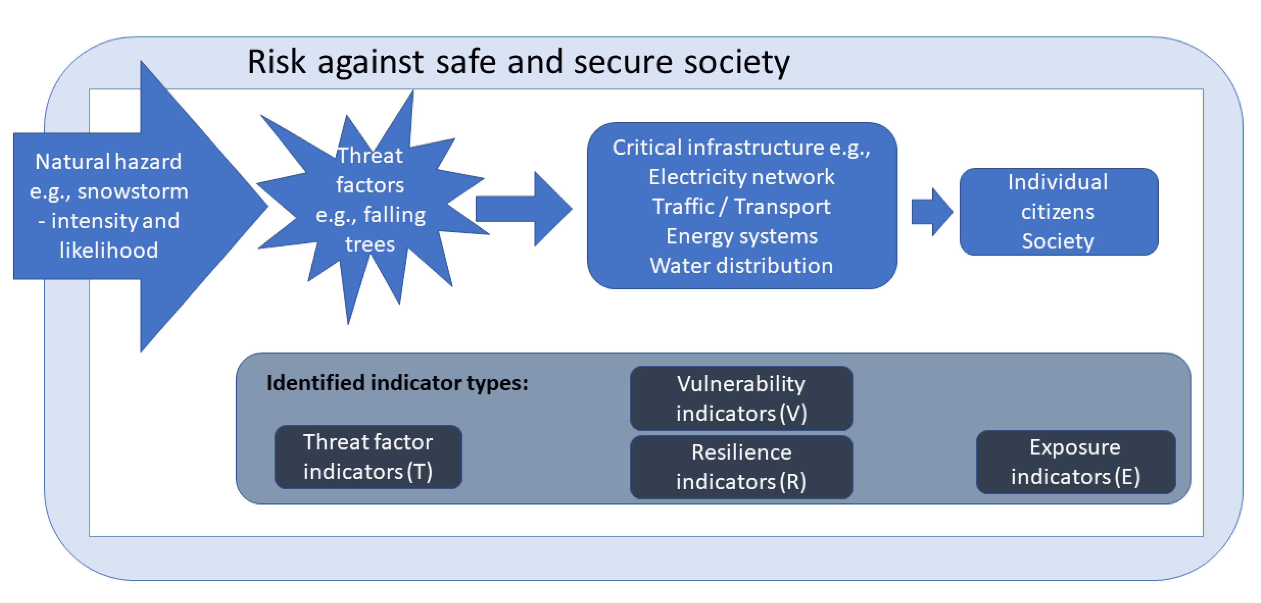
We focused on hazard, vulnerability, and resilience indicators regarding adverse climate events which impact, particularly at the local and regional level, on vital infrastructural services and people’s health and wellbeing. A single natural hazard can have many and various harmful impacts (threat factors) that affect different CIs, and as the chain of consequences progresses, a new threat factor may emerge. Any emerging adverse effect is a new threat to the next step in the chain of events (Figure 2). Thus, threat indicators emerge in several stages, as do vulnerability and resilience indicators. For the study, we divided indicators into four categories:
  • Threat factor indicators describe the harmful impacts caused by adverse weather events or unwanted changes in the environment affecting the safety or security level of society.
  • Exposure indicators describe features that make people or society as a whole prone to being impacted by the hazard or its cascading effects.
  • Vulnerability indicators describe the weaknesses of societal systems (i.e., CIs) that may be damaged due to the threat factors.
  • Resilience indicators describe the ability to function under natural pressure or to recover to a healthy situation.

1.2. Societal Risk Due to Natural Hazards

An indicator can be a single variable as well as a well-combined measure [35]. Ref. [36] defines an indicator as a sign that summarises the information relevant to a specific phenomenon. To find out what kind of data we can use as indicators, we studied weather and climate-related hazards and especially their cascading impacts on functions vital to society. Risk assessment explores how a specific hazard might exploit the vulnerability of a given system, how widely people would be exposed to the hazard or its cascading effects, and what is the level of coping capacity of the system including citizens, CI service providers, and disaster management authorities [37]. Natural hazard-originated risk (R) can be described as a function of hazard, vulnerability, exposure, and coping capacity [38,39,40] (Equation (1)).
R = H × V × E C C
Equation (1) suggests that if we could find data that tell us something about the state of hazard (H), vulnerability (V) or exposure (E) we could use these data as indicators to determine the potential risk level. Moreover, the equation states that the increase in coping capacity (CC) will decrease the risk.
Vulnerability is understood here as a quality of a system; it describes the propensity of an object to suffer adverse effects due to sensitivity or susceptibility, as well as a lack of flexibility and adaptability [41]. It is seen as an internal dynamic characteristic of a system, and hazards themselves evolve outside the target. As [42,43] suggest, vulnerability and resilience can be seen as opposite to each other: when resilience decreases, vulnerability increases. From the societal perspective there are other affecting factors, such as risk awareness and social capital, which may increase or decrease both vulnerability and resilience. However, it is useful to measure the risk with both vulnerability and resilience indicators, as they can highlight the cascading impacts from different perspectives. For example, the percentage of weather-proof electricity lines is a resilience indicator, and on the other hand, the percentage of weather-prone electricity lines is a vulnerability indicator.
It has been stated that exposure, E, is related to the potential average number of people who are exposed to hazards which depends on the location of people at a particular point of time [44]. Exposure can also be seen as the extent to which populations, economic activities and built environments are in contact with, or subject to hazards [45]. In this study, we focused on both; on people who are exposed to hazards and also on critical infrastructure which will suffer when a hazard takes place.
The hazard itself is too complex a factor to be useful in the systemic analytical risk assessment. The original natural hazard does not directly play a major role when the question is of disturbances in CIs or society [46]. Taking this into account, we used the term threat factor instead of (direct) hazard impact, stating that threat is a harmful cascading effect caused by a natural hazard or any other type of disaster targeting CI or a society [46,47,48,49]. In other words, threat factors help in better understanding the complex dynamic systems.
In addition, as [50] has noticed, disaster resilience integrates the adaptive, absorptive, and transformative capacity of society to withstand and cope with the adverse effects of the disaster. Thus, in our study in relation to CI, we didn’t use the term ”coping capacity”; instead, we used the term “resilience,” which is more familiar to stakeholders when studying CIs. Coping capacity is defined as the ability of the system to cope with an unwanted event and restore the function to its normal state [47], including the ability of people, organisations, and systems to manage adverse conditions. According to [51] the term “resilience” originates from the Latin word “resilio”, which signifies “to bounce back”. Resilience emphasises the capacity of a system to adapt to changes within its environment, and it expresses the system’s ability to anticipate, prepare for, respond to, and absorb shock, and to adapt and change positively when stress and challenges occur [52]. Resilience is seen either as a static or a continuously developing process [52,53]. In this study we selected the static view of resilience because of the practical work done by stakeholders to recognize resilience indicators. Because they work in actual crisis, they need to recognize indicators that are already available, and that can tell them something about the existing situation. Thus, resilience in this study means the capacity of a system and society to prevent the harmful impacts of hazards, and when a crisis takes place, the capacity to absorb the impact and to recover the normal state of operation [54].
Resilience indicators have recently been studied by [55,56], who focused on the qualitative and quantitative approaches to resilience assessment as well as indicators to compare crisis management strategies. These studies highlight that resilience has several domain areas, requiring different science inputs. They divide resilience assessment into two main groups: (1) inherent resilience (describing the pre-event resilience inside the community), and (2) adaptive resilience (describing the ability of individuals, stakeholders, and communities to learn from and respond to changes precipitated by some hazard event) [56].
Scientists have noted that in a system that is susceptible to cascade effects, the magnitude of systemic vulnerabilities is more defining than the magnitude of the original phenomenon [41]. Although the triggering of cascading disruptions such as natural hazards cannot be fully predicted, their risk potential can be integrated into preparedness and resilience thinking. CIs can be seen as metasystems of societal welfare, and by intervening in their functionality, it is possible to turn the system against itself. In other words, the sophistication of society also means increasing its potential insecurity [57].

1.3. Open Government Data as a Source of Indicators

Recent studies have found that open government data (OGD) can offer great opportunities to increase interaction between governments, NGOs, citizens, and the private sector [58,59,60]. OGD provides a wide range of opportunities to disseminate public sector information to other actors [61], such as private companies and NGOs. Opening government data in a free and machine-readable format has provided society with the opportunity to drive significant social, political, and economic changes [62,63]. The impact of OGD increases public accountability and improves public sector efficiency [59,63,64,65,66]. The government data used in this study consisted of records that the Finnish state, municipalities and regional authorities have collected from various sectors for years. These data enable the development of different kinds of indicators.
Due to the INSPIRE directive (Directive 2007/2/EC [67]) spatial data are nowadays more broadly available for various kinds of actions, and for commercial purposes. Some of the data can be used for describing the social and environmental spatial changes that have happened in society. In Finland, several data sets are available also to assess the level of safety and security, which was our focus. We did not aim to create any new data sets but tried to find out what data were already available for assessing the safety and security level of society regarding the hazard in question or its cascading consequences, and whether these data could be used to indicate the risk to the exposed CI and society.
Indicators mostly provide simplifications of a complex phenomenon. Good indicators are cost-effective to monitor, easy to understand, and relevant for decision-making. They must be targeted, have clear criteria for measuring them, be precise in their purpose and be easily accessible. In addition, they should be understandable to the target audience and good for the purpose for which they are used [36]. Data collectability is a significant criterion to achieve an applicable tool for measuring resilience indicators of critical infrastructure [37].
One way to monitor indicators is to use a trend analysis by monitoring the rise and fall of an indicator or the stability of the situation. Limit values may be given to the indicators, in which case the situation can be monitored via traffic-light type meters. Several different indicators may be used to describe the issue under consideration. Instead of single indicators, bundles of indicators could be used to describe various aspects of an issue or situation. It is necessary to determine whether the possible indicators are qualitatively valid, i.e., whether they really measure the aspect that should be measured.
To control something, we need to know what has happened in the past, what is happening now, and what may happen in the future [68]. In safety and security research, indicators have been assessed to provide information on current organisational safety and security performance. Commonly used indicators are often so-called lagging indicators, meaning that they measure the level of safety and security afterwards, for example describing what the situation was last year or several weeks ago. In the SmartResilience Horizon2020 project, we complemented lagging indicators with so-called leading indicators [69]. Leading indicators enable monitoring the effects of proactive safety and security work and help anticipate vulnerabilities in the future [70].

2. Materials and Methods

2.1. Methods to Visualise the Phenomenon

This research focuses on studying snowstorms in Finland, their consequences on society, and possible indicators that indicate how vulnerable or resilient society is against snowstorm phenomena. The study consists of five main steps. First, we prepared a preparatory causal loop diagram (CLD) to visualise the effects of a snowstorm on society. This was for later presentation in a stakeholder workshop with specific experts. Then, we defined the risk assessment method to be used in the stakeholder workshop for risk identification. Thirdly, the workshop participants were selected from the authorities or other stakeholders responsible for the functioning of critical infrastructure. Next, the workshop with the stakeholders was organized to improve the CLD and to identify indicators and relevant data sources for them. Finally, the results of the workshop were further analysed to find out what indicators were available and if they could be used for preparation against natural hazards, to determine the most vulnerable targets, and to recognize the best solutions for resilience against the emerging threats.
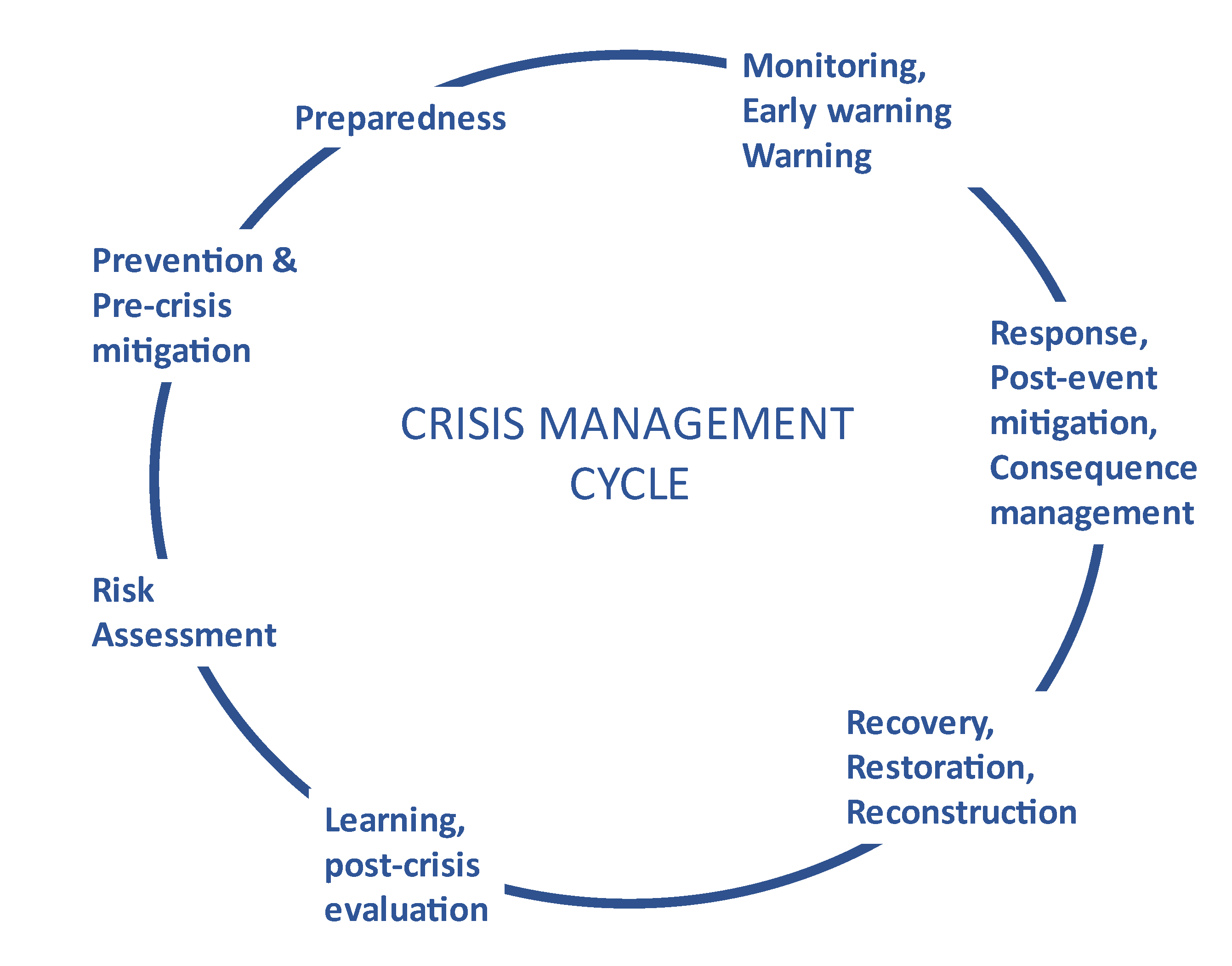
As part of the crisis management cycle (Figure 3), risk assessment takes place before preventive actions and preparedness stages guiding these operations [71]. Thus, risk assessment methods create an excellent background for anticipating the cascading effects of disasters. Event trees and cause-effect chains present the sequential events expanding the initial event into a series of new events [72]. Some methods, such as fault tree analyses [73], can be used to determine the root cause of a final occurring event.
When a natural hazard strikes, it often forms a chain of events with cascading effects. Like systemic risks [37,74,75], these cascading effects threaten critical aspects such as the health and welfare of the population, the power supply, transport logistics, telecommunication and information systems, and the environment. These effects fall under a distributed responsibility, and no one has the legitimacy to manage the entire system. Thus, the management of the aforementioned systems needs collaboration and information sharing between actors. In certain cases, the cascading effects may emerge as a global systemic risk, for example, if a lack of power supply terminates the functioning of international data centres.
Complex dynamic systems are challenging to understand. Dynamic complexity arises because systems change frequently, interact with each other, adapt, and are guided by feedback [76,77,78]. Dynamic system methods help in understanding the connections between different parts of the system. Systemic connections and feedback processes can cause conflicting and even unexpected results in the short and long term. Therefore, it is important to analyse the interconnections in different time horizons: short-, medium-, and long-term [77]. The starting point for modelling is to solve a specific problem, not to model the whole system because of the simplifying nature of the models [78].
In our study, we used a method called a “What–If Analysis” which is a useful solution to identify risks and their effects in collaborative planning cases [79]. This structured brainstorming method helps users to understand what can go wrong and how, and to judge the likelihood and consequences of those situations. Other strengths of the method are its relatively rapid implementation and that the major risks or sources of risks quickly become apparent [80].
A causal diagram is a useful tool to describe the feedback structure of a system [78,81]. To model reality, we used a systemic dynamic modelling method called a causal loop diagram (CLD). This can identify the different variables in a system and help in understanding how they interact.
CLD tools are helpful when you need to explain a conflict, the change of a system, or merely the interactions between variables [77]. A CLD tool includes arrows describing causal links between the variables. Each link has a polarity, which denotes the type of influence which can either positively strengthen the loop or negatively weaken it. A CLD shows predictable and immediate relations between elements. Furthermore, less straightforward relations can be shown in the diagram, making this tool useful in the initial stages of a project.
The chosen CLD tool, Vensim (https://vensim.com/ accessed on 21 June 2022) as used to visualise the interactions and qualitative relations between the chronological orders of a natural hazard event, starting from the adverse phenomenon and ending with harmful effects on citizens and infrastructure. The Vensim diagram shows only the qualitative relations between the elements [82]. We used three of four steps of CLD phases described by [37,78] to visualise the effects of harmful hazard impacts on the safety and security of the society:
  • Identification: definition of the variables to be included in the model.
  • Analysis: definition of the causal links between the variables.
  • Modelling: building a CLD diagram and using it to identify possibilities to monitor developing phenomena.
The polarity between causal links was not defined since all variables in the CLD diagram strengthened sequential variables.

2.2. Methods to Collect Focus Groups’ Knowledge

The workshop (expert workshop with focus groups [83]) took place in September 2019, with the representatives of non-governmental organisations, first responders and other agencies linked to crisis management. The 15 workshop participants operate on the national, regional, and local levels (see Table 1). Each group consisted of 4–5 participants. The participants were well informed about the content of the workshop, and they were free to leave it whenever they wanted to, and informed consent was obtained from all subjects involved in the study. The workshop was conducted in accordance with the Declaration of Helsinki (see Institutional Review Board Statement in the end of this article).
The aim of the workshop was to identify indicators and relevant sources of data related to natural hazards. As exemplary cases we used a series of snowstorms that took place in the Pirkanmaa area in 2015 (described in [12]). The participants of the workshop were divided into three groups and each group was facilitated by a researcher of the study. The facilitator’s role was to start the semi-structured group discussion and direct it to encompass all the planned themes and write down the main points of the discussion.
The workshop focused on the cascading consequences of an extensive power outage caused by a snowstorm. The discussion was facilitated by a visual causal loop diagram that described how the potential chains of disturbances could possibly affect hospitals, schools, the water supply, and supported accommodation units. Thus, the illustrative diagram described a fictional snowstorm, but the causal loops were based on formal reports of real-life events.
In the beginning, we presented the participants with several “what-if” questions. For example: “What could be the most significant consequences of a snowstorm?” or “Which consequences would be the most harmful to the critical sectors of society”? The participants went through the Vensim diagram chain-by-chain and discussed the various factors that could lead to disruption. Thereafter, they discussed and assessed the quality and quantity of preparedness to decide whether the current preparedness measures were adequate, who would be responsible for monitoring the situation and making the risk assessment, and who should collect data for this assessment.
In the second phase of the discussion, the participants tried to identify specific indicators that could help in noticing harmful progressions and hazard situations as early as possible. Possible indicators were linked to threat factors, vulnerabilities, exposures as well as protecting resilience. The questions raised at this point were: “What issues or phenomena are already being measured to get a situational picture of what is happening?” and “What could be measured and who could do this”?
The researcher and the facilitator of the group took notes of the discussions in a structured template (Figure 4). Using content analysis, we identified risk factors, actors, measures to adapt to or prevent snowstorms, as well as existing potential indicators and the roles and responsibilities of different stakeholders in a crisis situation.

3. Results

3.1. The Use of CLD

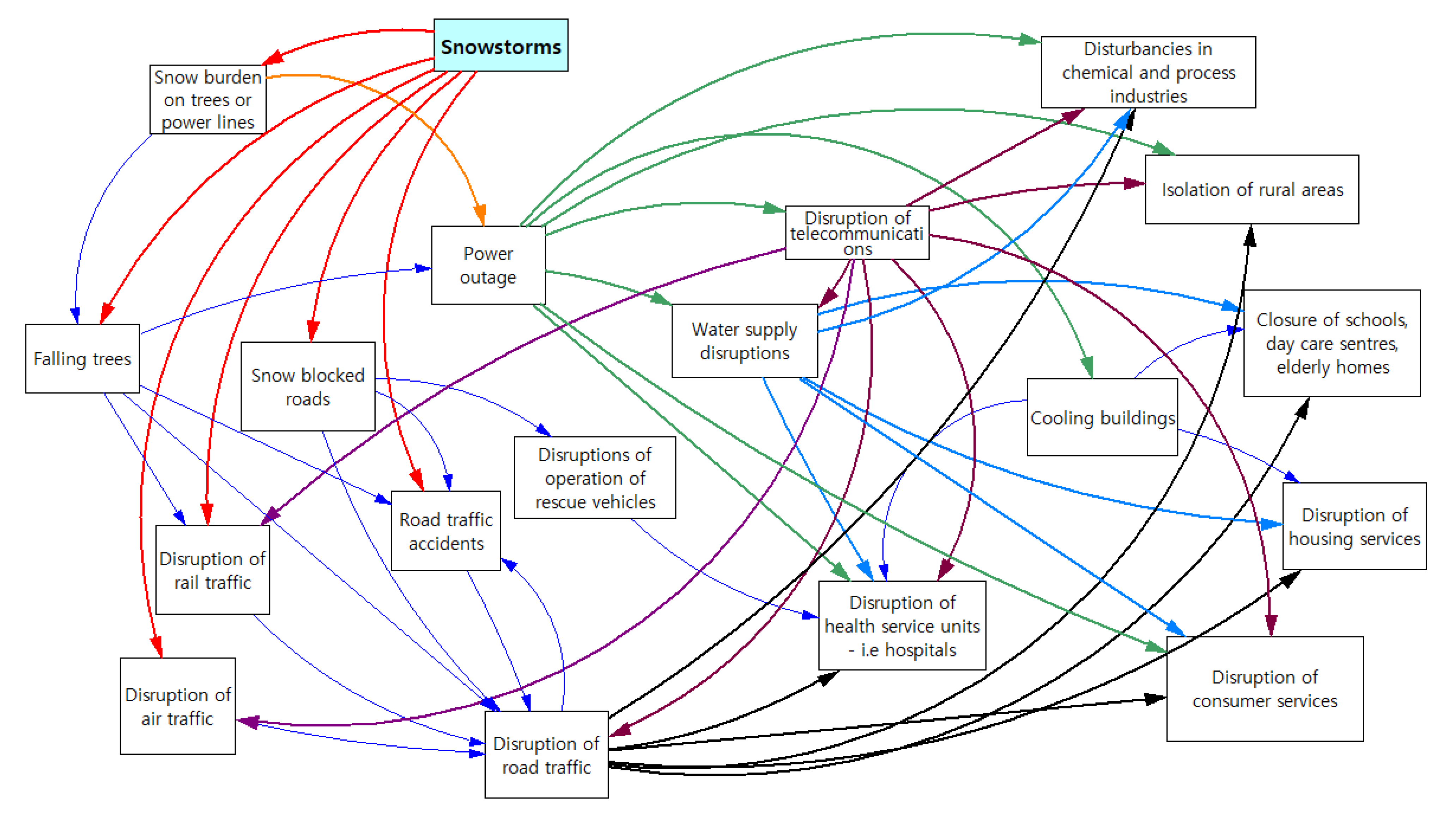
As described earlier, we had prepared an illustrative diagram of causal relationships in a snowstorm, based on the earlier impacts of adverse snowstorms and cold weather. In the workshop, we first validated the details of the diagram together with the stakeholders, but there was no need to amplify pre-specified nodes of the diagram. As the participants represented various fields of expertise, we were able to go through a variety of causal relationships that have an effect on society (Figure 5). The participants confirmed that there are effects that may take place independently, in parallel, or cascading and mutually reinforcing.
One observation from the point of exposure was the need to identify who might need external help the most. The elderly living alone without home help provided by social or health care services might become vulnerable during and after snowstorms. In normal situations, they might get along well, but in cold circumstances without electricity their coping capacity might fall dramatically. Especially without any societal support network, such as regular social or health care services, they are more at risk.
Based on the discussion in the expert workshop (focus group), impacts of a heavy snowstorm may generally be as follows. The first impacts of a snowstorms are snow-drifts and fallen trees. Heavy snow blocks roads and even railway lines, and major snow clearing is needed at airports. If the roads are blocked, other cascading impacts will happen. The immediate impacts may be traffic accidents, but blocked roads also disturb the operation of rescue vehicles and road traffic. If trees fall on power lines, there will be consequent power outages. This, in turn, has several impacts: the telecommunications network will operate for only a short time on reserve power, electrically heated buildings will cool without electricity, and service providers, such as water supply and health service units, will be harmfully affected and will need to adjust their operations based on reserve power or put contingency plans more thoroughly into operation. If a power outage lasts a longer time, public services may have to be discontinued. For instance, if the indoor temperature of schools or day care centres falls too much and there is no electricity in the buildings, students and children will not be allowed to attend. Power outages also have various effects on industrial sites, other consumer services, and households. Industrial sites and consumer services must adjust or potentially stop their operations during a power outage. From an exposure perspective, we could assess that the households, both in urban and rural areas, may be affected, but in general, power outages last longer in rural areas since maintenance work typically focuses first on areas with the most people.
The main issues of discussion are listed in Table 2. The first column includes the nodes of the diagram, explaining which harmful impact may happen. The second column describes the disturbance situation, and the third column describes possible preparedness actions or measures to minimise the impacts. The last column describes what kind of indicators are available to monitor the progression of impacts.

3.2. Analysing the Results for the Indicators

Table 2, above, provides an overview of the interpretations, ideas and worries regarding snowstorm situations as well as specific knowledge about the available measures that the stakeholders had. This knowledge was further analysed and classified to find the root sources for the situations, the necessary preparedness actions, as well as who would need to be responsible for ensuring the functioning of the CI in each case.
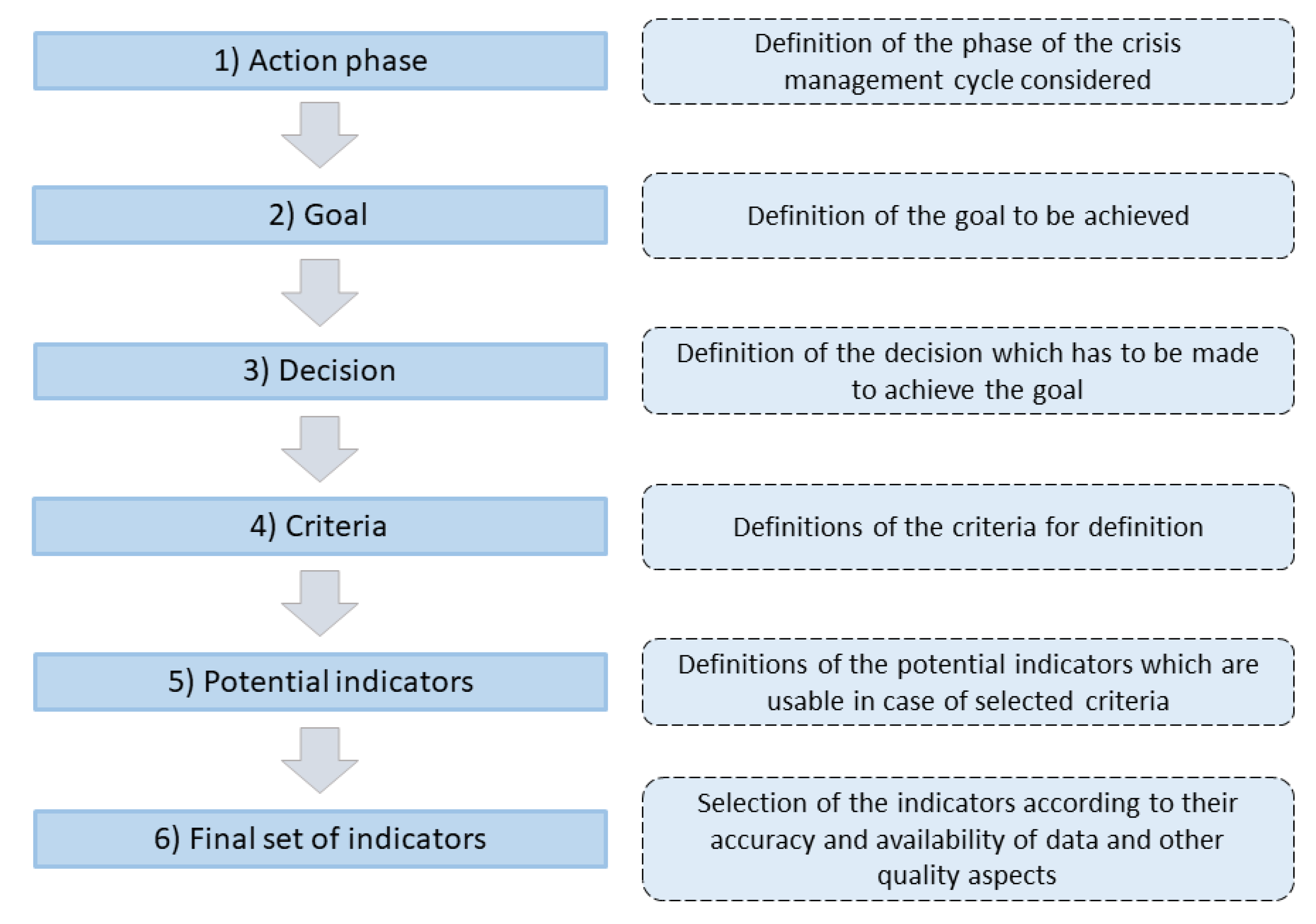
We further studied the emerging indicators to determine the responsible actors. Furthermore, the potential indicator data were studied according to the procedure (Figure 6) presented by [35]. This procedure provided a list of indicators.

3.3. Final Indicators

When studying the event chains and trying to identify indicators with stakeholders, we found that we needed to simplify the task by defining the variables’ vulnerability and resilience in relation to each other. In practice, it seemed that vulnerability and resilience form a pair; the same indicator may present either the vulnerability or resilience of the CI. This idea was supported by the workshop results: many of the indicators are like coins—one side presents a vulnerability indicator, and the other a resilience indicator. This is seen, for example, in the first line in Table 3: the percentage of weather-proof electricity lines is a resilience indicator; but on the other side, the percentage of weather-prone electricity lines is a vulnerability indicator. In Table 3 we have collected those indicators that are already available or could be monitored and for which data could be collected from authorities or stakeholders. In the Indicator Type column, T/E/V/R stand for threat factor, exposure, vulnerability, or resilience indicator, respectively, and lead/lag stand for leading or lagging indicator.
It is possible to identify those indicators that are already used for monitoring a certain phenomenon. It is also possible to identify the data already gathered, even though the data may not yet be utilised for a specific indicator. Many authorities and service providers already gather information and use different indicators to monitor the operation of various functions from their own perspectives. If they would share information or combine data from various sources or actors, it might be possible to formulate more indicators. This development could start with discussions on the already available data and how they could be more effectively and widely utilized. At the end of the study, we collected the identified indicators in the above table (Table 3).
The main topic of this study was to examine the impacts of climate-induced phenomena (in our case, a snowstorm), which consisted of three subtopics: (1) the increase in various extreme weather events, (2) preparedness and adaption to changing climate, and (3) environmental changes. These issues, in turn, include impacts on (a) infrastructure, (b) citizens’ health and living conditions, (c) animals, plants, and crops, and (d) buildings (see Table 3). For example, the growing number of days per year of heavy heat, storms, or cold indicates extreme weather phenomena. The number of nature-related rescue operations and the annual number of power outages caused by wind and storms describes the stress accrued by the authorities and households. Potential indicators may also include the number of critical properties as well as the number of weather-related traffic accidents.

4. Discussion

The aim of this research was to study how the data collected by various authorities can be used in ensuring the safety and security of citizens in cases of natural disasters. The idea was to form indicators from the existing data and study the possibility to use these data as indicators to evaluate the risk level of society. This may include various viewpoints that affect the safety and security of CIs and society, such as preparedness of authorities, cooperation between authorities and NGOs, preparedness of citizens against disasters, reserving emergency materials, and so forth. However, the goal of the study was not to provide final indicators for all the geographical regions in Finland or exact numerical value for the selected indicators, because the regions differ and have different kinds of safety and security challenges. Therefore, it is important that each region selects its own indicators and values for itself.
We held a workshop where the main stakeholders analysed, evaluated, and further developed a CLD that had been developed beforehand by the researchers, and they provided ideas for indicators for different steps of the diagram. The use of the CLDs supported the discussion in the workshop, which helped in understanding the interdependencies between various vital functions of society and the causal relationships of functional disruptions. Based on the diagram, it was possible to identify the phases of causal loops, from which information about a situation or malfunction can help the subsequent phases to be better prepared in advance for disruptions.
The workshop pointed out that the CLD based on system-dynamic modelling can be used to recognize the main indicators and needs for information in cases of natural hazards. This kind of tool makes it possible to go forward step-by-step together with stakeholders. With this kind of information, it is possible to identify the steps where it is possible to prevent and stop a harmful chain of events. CLD provides a visual way to observe the mutual dependencies [84] and thus, it gives a good overall picture of the work each stakeholder needs to do. The diagram also ensures the steps forward and backward for the identification of indicators and the missing information and data.
It is useful to study causal relationships at different times and identify the consequences of hazards in the short, medium, and long term [78]. In our study we focused on the immediate consequences of each studied chain and did not concentrate on long-term consequences. However, identifying (delayed) long-term consequences could be especially useful for authorities, other members of society, and citizens to be better prepared for all kinds of adverse events.
In this study, it was found that the risk formula used (Equation (1)) needs to be simplified for practical use, because determining the level of exposure in the system was very challenging. However, in order to improve risk assessment, it is also useful to identify exposure indicators. Above all, this avoids stereotypical generalisations about people’s vulnerability and coping capacity. For example, not all the elderly are equally vulnerable during a snowstorm. However, to find more practical indicators regarding vulnerability and resilience, we set exposure to a value of 1, which means that all CIs and society are exposed to the studied risk. We found that vulnerability and resilience indicators in many cases form two sides of the same coin as suggested by [43]; a small value for an indicator can indicate vulnerability, and a higher value can indicate resilience, and vice versa. Both can be used and their use depends on which one is easier to measure, for example, whether reliable and usable data are available.
Identifying indicators from a forecasting perspective was perceived as a challenge. Leading indicators are more difficult to formulate than lagging indicators, because data collected rarely provide early warning signs on potential weaknesses or future vulnerabilities in a risk control system or technology [70]. The exchange of information between different actors was perceived as one of the key opportunities. Many actors collect information and maintain indicators as part of their normal activities. The information already collected could also be useful for other actors in the region, and combined information could make it possible to develop new proactive indicators. This requires a discussion between the different actors about the information already collected and analysed and the possibilities to share the information with others. In the future, there may be more indicators describing the current state of the environment. For example, the monitoring of river and lake systems with the help of drones has already been tested.
Because the CLD used was a general presentation of the dependencies of various groups responsible for preparedness in society, there was no opportunity for a detailed analysis. A more precise description of these various groups and their sub-functions could help identify more indicators, and indeed the working group divided these groups into smaller sub-functions and examined them during the discussion. On the other hand, it is worth considering how detailed a CLD should be. If the diagram is primarily intended to facilitate a course of discussion according to a particular chain of events, it may not be necessary to make it very detailed. A more general CLD makes the participants’ own interpretation possible, allowing the discussion to emphasise the desired areas of expertise and the interests of the group members.
The study showed that multidisciplinary workshops would improve cooperation and understanding between authorities and other stakeholders. It helped the participants to effectively harvest different data sources to find new indicators—such as the resilience indicator for cooling buildings based on the building’s structure—that would help communities to be prepared for evacuations during snowstorms or cold waves. Multidisciplinary groups can be seen as a powerful approach to combining knowledge and creating valuable new ideas by using distributed cognition as well as an individual’s explicit knowledge [85], and groups encourage knowledge exchange and develop a deeper understanding of central issues important to the future [83]. As sharing and coordinating information during multi-agency disaster responses [86], information sharing is also important for the success of monitoring safety and security from a multi-agency perspective. The shared understanding of the potential impacts and consequences of crisis can facilitate the search for creative solutions to plan emergency responses and educate community members about potential harms [87]. When developing indicators for safety and security monitoring, it is highly useful to encourage different actors from various stakeholders to discuss the available information and how information can be used to achieve wider benefit.
The workshop revealed that there are parts of society for whom we do not have reliable information on the level of safety or preparedness for adverse climatic conditions. These groups include the elderly who are not registered for social services, and people with special needs in crisis communication, such as those who do not speak Finnish or Swedish. Many stakeholders noted that we lack indicators that could tell us how these people cope in different circumstances. For instance, it would be necessary to use indicators that are based on the data collected by NGOs and Non-Profit Organisations (NPOs). Quite often, NGOs or NPOs are focused on working and communicating with certain people or so-called customer segments, so they have good knowledge on possible difficulties and challenges people might face and the coping capacity people have in crisis. If NGOs or NPOs collect data that might be utilized in the development of indicators, it could extend the knowledge of crisis and preparedness beyond the authoritative level. Indicators based on the officials’ own records alone are not a sufficient measure of the people with special needs.

5. Conclusions

A systemic-dynamic methodology can be used in the context of regional preparedness planning where different stakeholders have their own roles and areas of responsibility. Strong cooperation between stakeholders enhances the understanding of mutual roles and expands the knowledge of the data that are collected from different organisations. The complex cause-and-effect relationships regarding the effects of climate extremes can be visualised by using CLDs of hazard situations at different levels, varying from general descriptions to more sophisticated and detailed descriptions.
The success of the workshop depends highly on the participating stakeholders. They should be experts in their field and be able to ideate what kind of cascading effects may emerge and threaten the functioning of the infrastructure or object they represent. They also need to have knowledge of the data that are already available and their limitations as well as how other stakeholders could receive and use them. It is beneficial to the discussion if the participating stakeholders have knowledge and practical experience of past natural hazards and their consequences.
This study showed that it is possible to identify hidden actors, such as vulnerable groups, as well as impacts and effects that are neither obvious nor already identified factors or targets in preparedness or contingency plans. We concentrated on the effects of natural phenomena and their impact on citizens, authorities, and services. By studying the effects of criminal acts and/or an economic catastrophe, the impact on citizens might be quite similar. By studying the ecological, financial, or political aspects, the whole picture including preventive measures, indicators, and responsible actors, could be quite different. Therefore, it is essential to identify and decide on the target and the basic needs for the CLD.
Strong visualisation is one major characteristics of the CLD used in this study. It visualises the interaction between different elements, sometimes showing numerous different linkages and thus the underlying complexity of entire systems. The diagram can be used as a tool for the identification of indicators, but it can also be seen as a tool to support preparedness planning. By examining the diagram and linkages between different elements, it is possible to go back and discuss in which phase or phases of a certain chain of events it is possible to obtain information, signals etc. of a possible negative progression. When widening the scope to identify actors involved in the monitoring, information sharing and analysis of collected data, we can analyse, develop, and improve the level of safety and security in society.

Author Contributions

Conceptualisation, R.M., J.K. and P.J.; methodology, R.M., J.K., T.K. and P.J.; validation, R.M. and P.J.; formal analysis, J.K. and T.K.; investigation, J.K., P.J. and T.K.; resources, R.M.; data curation, R.M. and J.K.; writing—original draft preparation, R.M., J.K. and T.K.; writing—review and editing, R.M., J.K., T.K. and P.J.; visualisation, R.M. and J.K.; supervision, R.M.; project administration, R.M.; funding acquisition, R.M., J.K., P.J. and T.K. All authors have read and agreed to the published version of the manuscript.

Funding

This research was funded by the Finnish Government ’s analysis, assessment and research program (VN TEAS) coordinated by the Prime Minister’s Office on the MATTI project (Funding number VNK/68/48/2019).

Institutional Review Board Statement

All subjects gave their informed consent for inclusion before they participated in the study. The study was conducted in accordance with the Declaration of Helsinki, and the protocol is approved by the Ethics Committee of VTT (Project number 121607).

Informed Consent Statement

Informed consent was obtained from all subjects involved in the study.

Conflicts of Interest

The authors declare no conflict of interest. The funders had no role in the design of the study; in the collection, analyses, or interpretation of data; in the writing of the manuscript, or in the decision to publish the results.

References

  1. Puustinen, A.; Kekki, T. Rescue Services and Civil Emergency Preparedness—Analysis of the Operating Environment; The Ministry of Interior: Helsinki, Finland, 2020; p. 90. (In Finnish)
  2. Molarius, R.; Könönen, V.; Leviäkangas, P.; Zulkarnain; Rönty, J.; Hietajärvi, A.-M.; Oiva, K. The extreme weather risk indicators (EWRI) for the European transport system. Nat. Hazards 2013, 72, 189–210. [Google Scholar] [CrossRef]
  3. Harjanne, A.; Haavisto, R.; Tuomenvirta, H.; Gregow, H. Risk management perspective for climate service development—Results from a study on Finnish organizations. Adv. Sci. Res. 2017, 14, 293–304. [Google Scholar] [CrossRef]
  4. Lizarralde, G.; Bornstein, L.; Robertson, M.; Gould, K.; Herazo, B.; Petter, A.-M.; Páez, H.; Díaz, J.H.; Olivera, A.; González, G.; et al. Does climate change cause disasters? How citizens, academics, and leaders explain climate-related risk and disasters in Latin America and the Caribbean. Int. J. Disaster Risk Reduct. 2021, 58, 102173. [Google Scholar] [CrossRef]
  5. Silvast, A.; Kongsager, R.; Lehtonen, T.-K.; Lundgren, M.; Virtanen, M. Critical infrastructure vulnerability: A research note on adaptation to climate change in the Nordic countries. Geogr. Tidsskr. J. Geogr. 2021, 121, 79–90. [Google Scholar] [CrossRef]
  6. The Council of the European Union. Council Directive 2008/114/EC on the Identification and Designation of European Critical Infrastructures and the Assessment of the Need to Improve their Protection. Official Journal of the European Union. 23.12. Available online: https://eur-lex.europa.eu/legal-content/EN/TXT/PDF/?uri=CELEX:32008L0114&from=en (accessed on 29 December 2021).
  7. Nazarnia, H.; Sarmasti, H.; Wills, W.O. Application of household disruption data to delineate critical infrastructure resilience characteristics in the aftermath of disaster: A case study of Bhaktapur, Nepal. Saf. Sci. 2019, 121, 573–579. [Google Scholar] [CrossRef]
  8. Veijalainen, N.; Ahopelto, L.; Marttunen, M.; Jääskeläinen, J.; Britschgi, R.; Orvomaa, M.; Belinskij, A.; Keskinen, M. Severe Drought in Finland: Modeling Effects on Water Resources and Assessing Climate Change Impacts. Sustainability 2019, 11, 2450. [Google Scholar] [CrossRef]
  9. Porthin, M.; Rosqvist, T.; Perrels, A.; Molarius, R. Multi-criteria decision analysis in adaptation decision-making: A flood case study in Finland. Reg. Environ. Change 2013, 13, 1171–1180. [Google Scholar] [CrossRef]
  10. Vajda, A.; Tuomenvirta, H.; Juga, I.; Nurmi, P.; Jokinen, P.; Rauhala, J. Severe weather affecting European transport systems: The identification, classification and frequencies of events. Nat. Hazards 2013, 72, 169–188. [Google Scholar] [CrossRef]
  11. Gregow, H.; Carter, T.; Groundstroem, F.; Haavisto, R.; Haanpää, S.; Halonen, M.; Harjanne, A.; Hildén, M.; Jakkila, J.; Juhola, S.; et al. Measures to Promote the Management of Weather and Climate Related Risks; Prime Minister’s Office: Helsinki, Finland, 2016. (In Finnish)
  12. Forssén, K.; Mäki, K.; Räikkönen, M.; Molarius, R. Resilience of Electricity Distribution Networks Against Extreme Weather Conditions. ASCE-ASME J. Risk Uncertain. Eng. Syst. Part B Mech. Eng. 2017, 3, 021005. [Google Scholar] [CrossRef]
  13. Lehtonen, I.; Venäläinen, A.; Kämäräinen, M.; Peltola, H.; Gregow, H. Risk of large-scale fires in boreal forests of Finland under changing climate. Nat. Hazards Earth Syst. Sci. 2016, 16, 239–253. [Google Scholar] [CrossRef]
  14. Carter, T.R.; Fronzek, S.; Inkinen, A.; Lahtinen, I.; Lahtinen, M.; Mela, H.; O’Brien, K.L.; Rosentrater, L.D.; Ruuhela, R.; Simonsson, L.; et al. Characterising vulnerability of the elderly to climate change in the Nordic region. Reg. Environ. Change 2014, 16, 43–58. [Google Scholar] [CrossRef]
  15. Kollanus, V.; Tiittanen, P.; Niemi, J.V.; Lanki, T. Effects of long-range transported air pollution from vegetation fires on daily mortality and hospital admissions in the Helsinki metropolitan area, Finland. Environ. Res. 2016, 151, 351–358. [Google Scholar] [CrossRef] [PubMed]
  16. Ministry of Agriculture and Forestry of Finland. Finland’s National Climate Change Adaptation Plan 2022; Government Resolution: Helsinki, Finland, 2014; ISBN 978-952-453-862-6.
  17. Forssén, K. Resilience of Finnish Electricity Distribution Networks against Extreme Weather Conditions. Master’s Thesis, Aalto University, School of Engineering, Helsinki, Finland, 6 March 2016; p. 105. Available online: https://aaltodoc.aalto.fi/bitstream/handle/123456789/19983/master_Forss%25E9n_Kim_2016.pdf?sequence=1 (accessed on 28 July 2021).
  18. Rauhala, J.; Juga, I. Wind and snowstorm impacts on society. In Proceedings of the SIRWEC the 15th International Road Weather Conference, Quebec City, QC, Canada, 5–7 February 2010; Available online: http://sirwec.org/wp-content/uploads/Papers/2010-Quebec/D-20.pdf (accessed on 28 July 2021).
  19. Ilkka, J.; Heikki, T.; Väinö, N. The variability of winter temperature, its impacts on society, and the potential use of seasonal forecasts in Finland. Weather 2012, 67, 328–332. [Google Scholar] [CrossRef]
  20. Molarius, R.; Keränen, J.; Schabel, J.; Wessberg, N. Creating a climate change risk assessment procedure: Hydropower plant case, Finland. Water Policy 2010, 41, 282–294. [Google Scholar] [CrossRef]
  21. Molarius, R.; Keränen, J.; Poussa, L. Combining Climate Scenarios and Risk Management Approach—A Finnish Case Study. Climate 2015, 3, 1018–1034. [Google Scholar] [CrossRef]
  22. Rutgersson, A.; Kjellström, E.; Haapala, J.; Stendel, M.; Danilovich, I.; Drews, M.; Jylhä, K.; Kujala, P.; Larsén, X.G.; Halsnæs, K.; et al. Natural hazards and extreme events in the Baltic Sea region. Earth Syst. Dyn. 2022, 13, 251–301. [Google Scholar] [CrossRef]
  23. Christiansen, B.; Alvarez-Castro, C.; Christidis, N.; Ciavarella, A.; Colfescu, I.; Cowan, T.; Yiou, P. Was the cold European winter of 2009/10 modified by anthropogenic climate change? An attribution study. J. Clim. 2018, 31, 3387–3410. [Google Scholar] [CrossRef]
  24. Stephenson, D.B. Definition, diagnosis, and origin of extreme weather and climate events. In Climate Extremes and Society; Murnane, R., Diaz, H., Eds.; Cambridge University Press: Cambridge, UK, 2008; pp. 11–23. [Google Scholar]
  25. Aaltola, M.; Juntunen, T. Nordic Model Meet Resilience—Finnish Strategy for Societal Security. In Expertise Mapping and Raising Policy Relevance; Latvian Institute of International Affairs: Riga, Latvia, 2018; pp. 26–42. [Google Scholar]
  26. The Finnish Government. Security Strategy for Society. Government Resolution; The Security Committee of Finland: Helsinki, Finland, 2017; p. 102. Available online: https://turvallisuuskomitea.fi/wp-content/uploads/2018/02/YTS_2017_suomi.pdf (accessed on 28 July 2021).
  27. Molarius, R.; Leviäkangas, P.; Keränen, J.; Juga, I.; Vajda, A. The effects of extreme weather on the European transport system: An analysis based on media reports. In Proceeding of the 7th European Conference on Severe Storms (ECSS 2013), Helsinki. Finland, 3–7 June 2013; p. 7. Available online: https://www.researchgate.net/publication/264193375_Te_effects_of_extreme_weather_on_the_European_transport_system_An_analysis_based_on_media_reports (accessed on 28 July 2021).
  28. Ministry of the Interior. National Guidelines for Safety Planning; Ministry of Interior: Helsinki, Finland, 2019; p. 36, (In Finnish). Available online: https://julkaisut.valtioneuvosto.fi/bitstream/handle/10024/161278/SM_2_2019_Turvallisuutta%20kaikkialla.pdf (accessed on 29 December 2021).
  29. Molarius, R.; Jukarainen, P.; Kekki, T.; Keränen, J.; Laitinen, K.; Riikonen, R.; Norri-Sederholm, T. The State of Regional Security (ATT)—A Monitoring, Evaluation and Forecasting Model to Support Regional Security Planning and Preparedness; Prime Minister’s Office: Helsinki, Finland, 2020; p. 94, (In Finnish). Available online: https://julkaisut.valtioneuvosto.fi/bitstream/handle/10024/162196/VNTEAS_2020_21.pdf (accessed on 15 June 2022).
  30. Edwards, A. Introducing the Resourceful Practitioner. In Being an Expert Professional Practitioner: The Relational Turn in Expertise, 3rd ed.; Edwards, A., Ed.; Springer: London, UK, 2010; Volume 3, pp. 1–20. [Google Scholar]
  31. Leathard, A. Introduction. In Interprofessional Collaboration: From Policy to Practice in Health and Social Care; Leathard, A., Ed.; Routledge: London, UK, 2003; pp. 3–11. [Google Scholar]
  32. Molarius, R. Foreseeing Risks Associated with New Technologies—Cooperation of the Authorities to Prevent Technical Risks Due to New Technologies. Ph.D. Thesis, Tampere University of Technology, Tampere, Finland, 29 April 2016; p. 211. (In Finnish). Available online: https://trepo.tuni.fi/bitstream/handle/10024/114043/S120_Uusien_tekniikoiden_riskien_ennakointi.pdf?sequence=1 (accessed on 28 July 2021).
  33. Renn, O. Risk communication and the social amplification of risk. In Communicating Risks to the Public: International Perspectives; Kasperson, R.E., Stallen, P.J.M., Eds.; Springer: London, UK, 1991; pp. 287–324. [Google Scholar]
  34. Mahdavian, F.; Platt, S.; Wiens, M.; Klein, M.; Schultmann, F. Communication blackouts in power outages: Findings from scenario exercises in Germany and France. Int. J. Disaster Risk Reduct. 2020, 46, 101628. [Google Scholar] [CrossRef]
  35. Birkmann, J. Indicators and criteria for measuring vulnerability; Theoretical bases and requirements. In Measuring Vulnerability to Natural Hazards: Towards Disaster Resilient, Societies; Birkman, J., Ed.; United Nations University: Tokyo, Japan, 2006; pp. xxvi–524. Available online: https://www.cdema.org/virtuallibrary/images/Measuring%20Vulnerability_Birkmann_2006.pdf#page=36 (accessed on 14 July 2022).
  36. Hollnagel, E.; Woods, D.D.; Leveson, N. Resilience Engineering: Concepts and Precepts; Taylor and Francis: Boca Raton, FL, USA, 2006. [Google Scholar]
  37. IRGC. Guidelines for the Governance of Systemic Risks; International Risk Governance Center (IRGC): Lausanne, Switzerland, 2018. Available online: https://irgc.org/risk-governance/systemic-risks/guidelines-governance-systemic-risks-context-transitions/ (accessed on 28 July 2021).
  38. DasGupta, R.; Shaw, R. Disaster risk reduction: A critical approach. In The Routledge Handbook of Disaster Risk Reduction Including Climate Change Adaptation; Routledge: London, UK, 2017; pp. 12–23. Available online: https://www.routledgehandbooks.com/doi/10.4324/9781315684260.ch3 (accessed on 16 June 2022).
  39. Egawa, S.; Murakami, A.; Sasaki, H. Healthy community resilient against disaster. In The 2011 Japan Earthquake and Tsunami: Reconstruction and Restoration; Santiago-Fandiño, V., Sato, S., Maki, N., Iuchi, K., Eds.; Springer: Cham, Switzerland, 2018; pp. 139–152. [Google Scholar]
  40. Peters, L.E. Beyond disaster vulnerabilities: An empirical investigation of the causal pathways linking conflict to disaster risks. Int. J. Disaster Risk Reduct. 2021, 55, 102092. [Google Scholar] [CrossRef]
  41. The Intergovernmental Panel on Climate Change (IPPC). Climate Change 2014: Synthesis Report. Contribution of Working Groups I, II and III to the Fifth Assessment Report of the Intergovernmental Panel on Climate Change; Core Writing Team, Pachauri, R.K., Meyer, L.A., Eds.; IPCC: Geneva, Switzerland, 2014; p. 169. Available online: https://www.ipcc.ch/site/assets/uploads/2018/05/SYR_AR5_FINAL_full_wcover.pdf (accessed on 29 December 2021).
  42. Morsut, C.; Kuran, C.; Kruke, B.I.; Orru, K.; Hansson, S. Linking resilience, vulnerability, social capital and risk awareness for crisis and disaster research. J. Contingencies Crisis Manag. 2021, 30, 137–147. [Google Scholar] [CrossRef]
  43. Twigg, J. Characteristics of a Disaster Resilient Community. 2007. Available online: http://repo.floodalliance.net/jspui/handle/44111/1328 (accessed on 14 June 2022).
  44. UNU-EHS. World Risk Report; Bündnis Entwickling Hilft: Berlin, Germany, 2021; p. 74. Available online: https://www.preventionweb.net/files/21709_worldriskreport2011.pdf (accessed on 29 December 2021).
  45. Garschagen, M.; Romero-Lankao, P. Exploring the relationships between urbanization trends and climate change vulnerability. Clim. Chang. 2013, 133, 37–52. [Google Scholar] [CrossRef]
  46. Pescaroli, G.; Alexander, D. Critical infrastructure, panarchies and the vulnerability paths of cascading disasters. Nat. Hazards 2016, 82, 175–192. [Google Scholar] [CrossRef]
  47. Sperstad, I.B.; Kjølle, G.H.; Gjerde, O. A comprehensive framework for vulnerability analysis of extraordinary events in power systems. Reliab. Eng. Syst. Saf. 2019, 196, 106788. [Google Scholar] [CrossRef]
  48. Jasper, S.E. U.S. Cyber Threat Intelligence Sharing Frameworks. Int. J. Intell. Count. 2016, 30, 53–65. [Google Scholar] [CrossRef]
  49. Tosh, D.K.; Shetty, S.; Sengupta, S.; Kesan, J.P.; Kamhoua, C.A. Risk management using cyber-threat information sharing and cyber-insurance. In Game Theory for Networks, Proceedings of the 7th International EAI Conference, GameNets, Knoxville, TN, USA, 9 May 2017; Duan, L., Sanjab, A., Li, H., Chen, X., Materassi, D., Eds.; Springer: Cham, Switzerland, 2017; pp. 154–164. [Google Scholar] [CrossRef]
  50. Sarker, M.N.I.; Wu, M.; Chanthamith, B.; Ma, C. Resilience through big data: Natural disaster vulnerability context. In Proceedings of the Fourteenth International Conference on Management Science and Engineering Management; Xu, J., Duca, G., Ahmed, S.E., Márquez, F.P.G., Eds.; Springer: Cham, Switzerland, 2020. [Google Scholar] [CrossRef]
  51. Klein, B.; Koenig, R.; Schmitt, G. Managing Urban Resilience. Inform. Spektrum 2016, 40, 35–45. [Google Scholar] [CrossRef]
  52. ISO/TR22370; Security and resilience—Urban resilience—Framework and principles. ISO Copyright Office: Geneva, Switzerland, 2020.
  53. Cerè, G.; Rezgui, Y.; Zhao, W. Critical review of existing built environment resilience frameworks: Directions for future research. Int. J. Disaster Risk Reduct. 2017, 25, 173–189. [Google Scholar] [CrossRef]
  54. Labaka, L.; Hernantes, J.; Sarriegi, J.M. Resilience framework for critical infrastructures: An empirical study in a nuclear plant. Reliab. Eng. Syst. Saf. 2015, 141, 92–105. [Google Scholar] [CrossRef]
  55. Cutter, S.L.; Burton, C.G.; Emrich, C.T. Disaster Resilience Indicators for Benchmarking Baseline Conditions. J. Homel. Secur. Emerg. Manag. 2010, 7, 1–22. [Google Scholar] [CrossRef]
  56. Engelbach, W.; Frings, S.; Molarius, R.; Aubrecht, C.; Meriste, M.; Perrels, A. Indicators to compare simulated crisis management strategies. In Proceedings of the International Disaster and Risk Conference, IDCR, Integrative Risk Management—Towards Resilient Cities, Davos, Switzerland, 24–28 August 2014; pp. 24–28. [Google Scholar]
  57. Heino, O.; Takala, A.; Jukarainen, P.; Kalalahti, J.; Kekki, T.; Verho, P. Critical Infrastructures: The Operational Environment in Cases of Severe Disruption. Sustainability 2019, 11, 838. [Google Scholar] [CrossRef]
  58. Bertot, J.C.; Gorham, U.; Jaeger, P.T.; Sarin, L.C.; Choi, H. Big data, open government and e-government: Issues, policies and recommendations. Inf. Polity 2014, 19, 5–16. [Google Scholar] [CrossRef]
  59. Magalhaes, G.; Roseira, C. Open government data and the private sector: An empirical view on business models and value creation. Gov. Inf. Q. 2020, 37, 101248. [Google Scholar] [CrossRef]
  60. Saxena, S.; Muhammad, I. Barriers to use open government data in private sector and NGOs in Pakistan. Inf. Discov. Deliv. 2018, 46, 67–75. [Google Scholar] [CrossRef]
  61. Borglund, E.; Engvall, T. Open data? Data, information, document or record? Rec. Manag. J. 2014, 24, 163–180. [Google Scholar] [CrossRef]
  62. Jetzek, T.; Avital, M.; Bjørn-Andersen, N. The generative mechanisms of open government data. In Proceedings of the 21st European Conference on Information Systems, ECIS 2013, Utrecht, The Netherlands, 14–18 August 2013; Proceeding Paper 179. Available online: https://aisel.aisnet.org/ecis2013_cr/156/ (accessed on 28 July 2021).
  63. Halonen, A. Being Open about Data: Analysis of the UK Open Data Policies and Applicability of Open Data; The Finnish Institute: London, England, 2012; Available online: http://www.fininst.uk/wp-content/uploads/2017/09/being-open-about-data.pdf (accessed on 14 July 2022).
  64. Kulk, S.; Van Loenen, B. Brave new open data world? Int. J. Spat. Data Infrastruct. Res. 2012, 7, 196–206. [Google Scholar] [CrossRef]
  65. Longo, J. #Opendata: Digital-era governance thoroughbred or new public management Trojan horse? Public Policy Gov. Rev. 2011, 2, 38. Available online: https://ssrn.com/abstract=1856120 (accessed on 14 July 2022).
  66. Davies, T.; Perini, F. Researching the emerging impacts of open data: Revisiting the ODDC conceptual framework. J. Community Inform. 2016, 12, 148–178. [Google Scholar] [CrossRef]
  67. The European Parliament and the Council of the European Union. Directive 2007/2/EC, 14 March 2007 Establishing an Infrastructure for Spatial Information in the European Community (INSPIRE). OJ L 108, 25.4.2007. pp. 1–14. Available online: https://inspire.ec.europa.eu/documents/directive-20072ec-european-parliament-and-council-14-march-2007-establishing (accessed on 29 December 2021).
  68. Balaei, B.; Wilkinson, S.; Potangaroa, R.; McFarlane, P. Investigating the technical dimension of water supply resilience to disasters. Sustain. Cities Soc. 2020, 56, 102077. [Google Scholar] [CrossRef]
  69. Jovanović, A.; Øien, K.; Choudhary, A. An indicator-based approach to assessing resilience of smart critical infrastructures. In Urban Disaster Resilience and Security; Fekete, A., Fiedrich, F., Eds.; Springer: Cham, Switzerland, 2018; pp. 285–311. [Google Scholar]
  70. Reiman, T.; Pietikäinen, E. Indicators of Safety Culture—Selection and Utilization of Leading Safety Performance Indicators; Report Number: 2010:07; Swedish Radiation Safety Authority, SSM: Stockholm, Sweden, 2010; p. 72. Available online: https://www.osti.gov/etdeweb/servlets/purl/979791 (accessed on 22 June 2022).
  71. Pursiainen, C.; Bjarte, R.; Baker, G.; Honfi, D.; Lange, D. Critical infrastructure resilience index. In Proceedings of the Risk, Reliability and Safety: Innovating Theory and Practice, 26th European Safety and Reliability Conference ESREL, Glasgow, UK, 25–29 September 2016; p. 355. [Google Scholar]
  72. Suokas, J.; Rouhiainen, V. Quality control in safety and risk analyses. J. Loss Prev. Process. Ind. 1989, 2, 67–77. [Google Scholar] [CrossRef]
  73. Pursiainen, C. Critical infrastructure resilience index. In the ERNCIP Project Platform. European Commission Joint Research Centre JRC, Ispra. 2016. Available online: https://erncip-project.jrc.ec.europa.eu/sites/default/files/ERNCIP-IMPROVER-2016-Pursiainen.pdf (accessed on 14 July 2022).
  74. Renn, O.; Lucas, K.; Haas, A.; Jaeger, C. Things are different today: The challenge of global systemic risks. J. Risk Res. 2017, 22, 401–415. [Google Scholar] [CrossRef]
  75. Renn, O.; Laubichler, M.; Lucas, K.; Kröger, W.; Schanze, J.; Scholz, R.W.; Schweizer, P. Systemic Risks from Different Perspectives. Risk Anal. 2020, 1–19. Available online: https://onlinelibrary.wiley.com/doi/full/10.1111/risa.13657 (accessed on 21 June 2022). [CrossRef]
  76. Sterman, J. System dynamics: Systems thinking and modelling for a complex world. MIT. Engineering systems division. Work. In ESD Working Papers, Proceedings of the ESD Internal Symposium; Massachusetts Institute of Technology: Cambridge, UK, 2002; p. 31. Available online: http://hdl.handle.net/1721.1/102741 (accessed on 28 July 2021).
  77. Dufva, M.; Ahlqvist, T. How to Enhance the Futures Dialogue between the Government and Parliament? The Finnish Government: Helsinki, Finland, 2015; p. 57, (In Finnish). Available online: https://julkaisut.valtioneuvosto.fi/bitstream/handle/10024/79546/miten%20edist%c3%a4%c3%a4%20hallituksen%20ja%20eduskunnan.pdf?sequence=1&isAllowed=y (accessed on 28 December 2021).
  78. Sterman, J. Business Dynamics: Systems Thinking and Modeling for a Complex World, 1st ed.; McGraw-Hill Education: Boston, MA, USA, 2000. [Google Scholar]
  79. Klosterman, R.E. The What if? Collaborative planning support system. Environ. Plan. B Plan. Des. 1999, 26, 393–408. [Google Scholar] [CrossRef]
  80. SFS-EN IEC 31010:2019; Risk Management. Risk Assessment Techniques. Finnish Standards Association SFS: Helsinki, Finland, 2019.
  81. Delgado-Maciel, J.; Cortés-Robles, G.; Alor-Hernández, G.; Garcí Alcaráz, J.; Negny, S. A comparison between the Func-tional Analysis and the Causal-Loop Diagram to model inventive problems. Procedia CIRP 2018, 70, 259–264. [Google Scholar] [CrossRef]
  82. Vensim®. User’s Guide Version 5; Ventana Systems, Inc.: Harvard, MA, USA, 2007. [Google Scholar]
  83. Molarius, R.; Wessberg, N.; Keränen, J.; Murtonen, M. Foresight in Sight: How to Improve Urban Resilience with Collaboration Among Public Authorities? In Urban Disaster Resilience and Security; Springer: Cham, Switzerland, 2017; pp. 397–412. [Google Scholar] [CrossRef]
  84. Berariu, R.; Fikar, C.; Gronalt, M.; Hirsch, P. Understanding the impact of cascade effects of natural disasters on disaster relief operations. Int. J. Disaster Risk Reduct. 2015, 12, 350–356. [Google Scholar] [CrossRef]
  85. Nonaka, I. A Dynamic Theory of Organizational Knowledge Creation. Organ. Sci. 1994, 5, 14–37. [Google Scholar] [CrossRef]
  86. Bharosa, N.; Lee, J.; Janssen, M. Challenges and obstacles in sharing and coordinating information during multi-agency disaster response: Propositions from field exercises. Inf. Syst. Front. 2009, 12, 49–65. [Google Scholar] [CrossRef]
  87. Shmueli, D.F.; Ozawa, C.P.; Kaufman, S. Collaborative planning principles for disaster preparedness. Int. J. Disaster Risk Reduct. 2020, 52, 101981. [Google Scholar] [CrossRef]
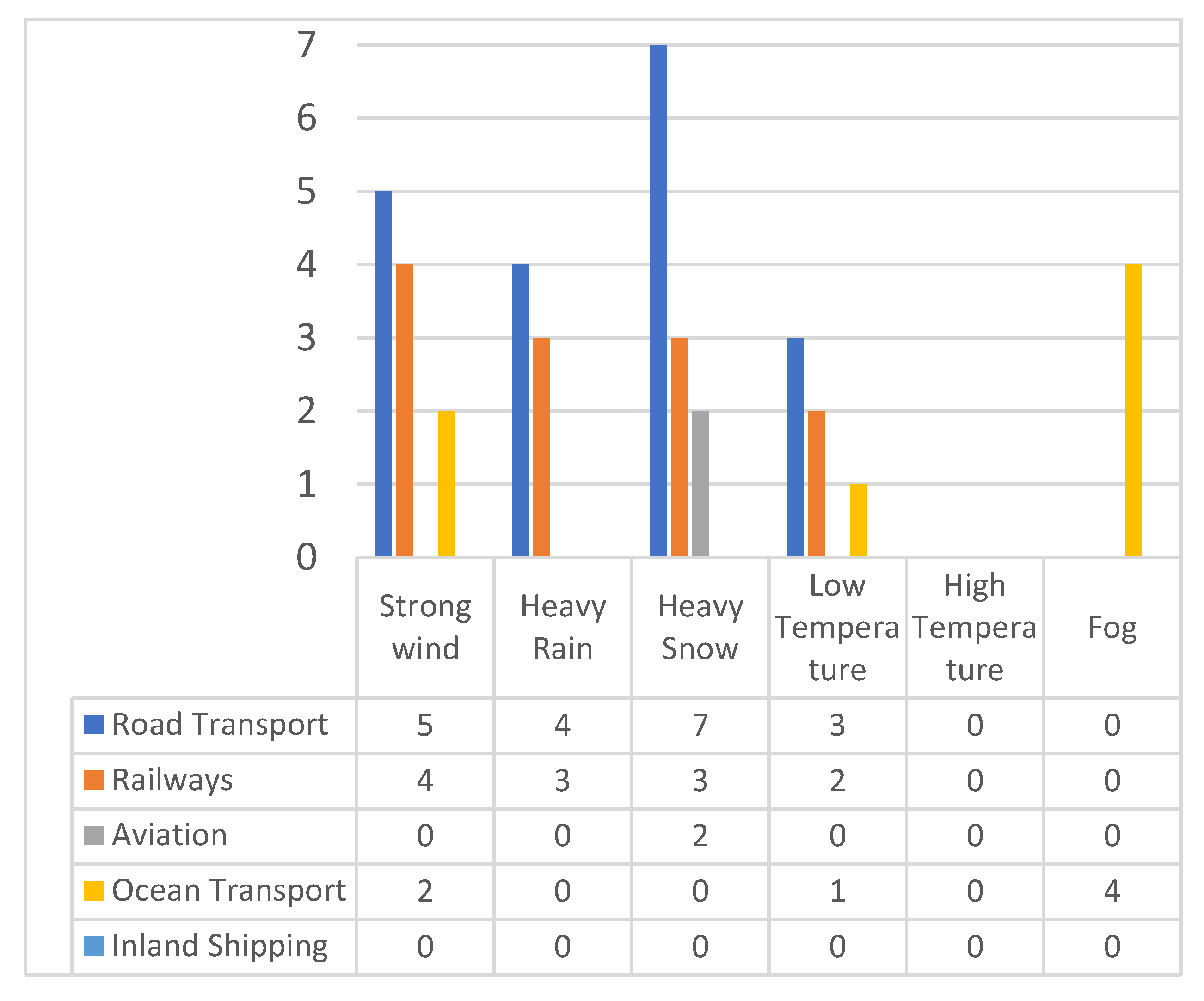
Figure 1. The number of extreme weather events impacting different transport modes in 2000–2010 in the Nordic countries [27].
Safety 08 00060 g001
Figure 2. Framework to look for the indicators to assess the risk against a safe and a secure society.
Safety 08 00060 g002
Figure 3. The stages of a crisis management cycle [71].
Safety 08 00060 g003
Figure 4. Template for collecting discussion notes in the workshop.
Safety 08 00060 g004
Figure 5. The causal loop diagram regarding the effects of a snowstorm in Finland.
Safety 08 00060 g005
Figure 6. The methodology used to assess indicators [modified from [35]].
Safety 08 00060 g006
Table 1. The participants of the stakeholder workshop regarding the cascading effects of a snowstorm and cold weather.
StakeholderAuthority TypeArea of Responsibility
Centre for Economic Development, Transport and the EnvironmentRegional authorityMaintaining of road traffic, building, and maintenance including snow ploughing and salting.
Rescue servicesRegional authorityFirefighting, maintaining rescue actions including clearing fallen trees from main roads and railways together with distribution system operators (DSOs)
PoliceRegional authorityMaintaining general security and evacuation activities in cases of fires and when buildings become too cold to stay in.
City of TampereLocal authorityMaintaining health, social and educational activities on the local level
The council of Tampere the region Regional authoritySupervising the development and land use of the whole region.
Finnish Safety and Chemicals Agency State authoritySupervision of industry, including SEVESO enterprises and mines.
Forest CentreRegional authoritySupervising and guiding forest owners, following forest growth in woods including the electricity network corridors
University of Eastern FinlandAcademic Education
Table 2. Summary of results of the workshop.
Vensim Diagram of a Major Snowstorm
Node in Vensim DiagramWhat is the Resulting Situation?
What Factors Made This Possible?
What Possible Actions Exist?
Are the Preparedness Activities Adequate?
Which Indicators Are Available for Evaluating the Effects of the Snowstorm?
Disruption of telecommunicationsPower supply to the base stations is cut off.
Battery capacity of ordinary mobile phones is about four hours.
The base station maintenance times extension with fuel cell-based solutions (testing ongoing).
Ensure continuous maintenance (service route/road connection).
A reserve power system using renewable energy should be developed.
Operators of telecommunication networks, connection with satellite phones to the control unit.
Statistics on the interruption of the power supply.
Power outage in rural areasCooling of buildings during power outage
Oil and electrically heated systems stop working.
Payment systems in stores, service stations etc. stop working.
Disruptions in farming activities and systems.
Heat absorption capacity of buildings varies. The length of a power failure is critical for evacuation.
Temporary facilities and their heating systems.
Mobile heating devices.
Informal credit payment if payment transactions are inactive.
Backup power systems for a sufficient time period and adequate fuel supply.
Expansion of the distribution station network.
Home emergency supply kit.
Food and fuel distribution networks have been analysed in the logistics sector (the number of companies).
Statistics on power interruption and the outage.
Regional authorities’ task data (evacuation, distribution of equipment for preparation, such as electric generators etc.).
Surveys of citizens’ preparedness.
Problems in telecommunications Communication problems in different information channels, e.g., blocked emergency messages.
Telecommunication in agricultural systems is blocked.
Independent preparedness (battery radios).
Rescue services should be ready to arrange emergency first aid and communication sites.
Resources of volunteers.
Telecommunication network operators.
Statistics on interruptions of telecommunication channels.
Trees fall on electrical linesMedium voltage (20 kV) electrical lines break down due to falling trees (snow burden on trees).Wider treeless lane next to electrical lines. Thinning of trees near electrical lines.
Ensure bidirectional power supply for residential areas in planning.
Forest owners interest organisations could maintain information based on laser scanning and (forest) height growth.
Water supply disruptionWater tower capacity is limited.
Sewage disposal, overflows (albeit minor).
Hot water distribution off.
Water supply to animal shelters may be disturbed.
Arrangement of filtration methods for reserve water.
Backup power arrangements for pumping stations.
Reserve water included in the home emergency supply kit.
Adequate number of clean water tanks and pumps (combustion engine application).
Maintenance of interwall of wells.
Disruption of road or rail trafficFallen trees, snowstorm, accidents block traffic.
Prevention of first responders’ operational actions.
Fallen trees near the road complicates the use of reserve power and water distribution.
Heavy clearing equipment and resources (rescue services, loggers).
Transport equipment of defence forces with administrative assistance
Passenger traffic disrupted, alternative mode of transport to workplaces.
Disruptions of timber and chemical logistics to industrial sites. Alternative modes of transport needs to be planned.
Emergency task statistics concerning disruptions of road and rail traffic.
Disruption of logisticsDisruptions of food supply, fuel distribution, police, and rescue services.
Sense of security may fall.
Local authorities as a part of social and health services.
Updating contingency plans.
Civic warnings.
Ensuring medicine supply.
Neighbourly help.
Monitoring of condition and survival of the elderly should be arranged.
Level of beverage/water and food storage (home emergency supply kit for 72 h).
Fuel and firewood storage.
Organisations agree and cooperate with local authorities.
Table 3. Indicators identified in the workshop.
Adverse ImpactPreventive ActionIndicator Indicator TypeData Availability
T/E/V/RLead/Lag
Trees falling on overhead electricity linesAdjacent forest management (right-of-way)
Forestry maintenance near electric lines
Percentage value of weather-proof electric lines
Number of inhabitants in the area of the “storm-prone” network
Duration of power cut longer than six hours
Resilience


Vulnerability


Threat factor
Leading


Leading


Lagging
Distribution System Operators
Roads blocked by snowOn-time snow ploughingAmount of plough-equipment available per 50 km of main road
Amount and location of critical logistics sites (farms, stocks of food and other critical materials)
Resilience


Vulnerability
Leading


Leading
Road operators
Cooling apartments during a power cut-offThe effectiveness of insulationTime that indoor temperature falls below +14 °C when outside temperature is −20 °CResilienceLeadingNational building information register
Lack of rescue services during a long-lasting disruptionAdequate resources (personnel, equipment etc.)Regional volunteer capacity ResilienceLaggingRescue services
Citizens coping with hazardsSelf-preparednessNumber of citizens able to cope 72 h without helpResilience
Exposure
Leading
Leading
Not available
Water supply disruptionsPreparedness against disruptions with water towers and reserve water pumpsInterruptions in water distribution due to power cuts
Number of critical water consumers
Vulnerability


Vulnerability
Lagging


Lagging
Water supplier
Publisher’s Note: MDPI stays neutral with regard to jurisdictional claims in published maps and institutional affiliations.