Article

Rangeland Management and Ecological Adaptation Analysis Model for Astragalus curvirostris Boiss

by
Farhad Aghajanlou
1,*,
Hamidreza Mirdavoudi
2,
Mohammad Shojaee
1,
Eileen Mac Sweeney
3,
Andrea Mastinu
3,*,† and
Parviz Moradi
1,†
1
Agricultural and Natural Resources Research and Education Center, AREEO, Zanjan 45371, Iran
2
Markazi Agricultural and Natural Resources Research and Education Center, AREEO, Arak 32802, Iran
3
Department of Molecular and Translational Medicine, University of Brescia, 25123 Brescia, Italy
*
Authors to whom correspondence should be addressed.
Authors with equal contribution.
Horticulturae 2021, 7(4), 67; https://doi.org/10.3390/horticulturae7040067
Submission received: 2 March 2021 / Revised: 20 March 2021 / Accepted: 30 March 2021 / Published: 2 April 2021
(This article belongs to the Special Issue Sustainable Horticulture under Biotic and Abiotic Stresses)

Abstract

:
The present study investigates the ecological requirements of Astragalus curvirostris Boiss, with emphasis on determining the ecological factors that affect the distribution of plant species, and the species’ response to changes in ecological factors using a Generalized Additive Model (GAM) in the Iranian Province of Zanjan from 2017 to 2019. Randomized-systematic sampling was used to collect vegetation data. Data analysis was performed using SPSS17 and CANOC4.5 software. The results showed that the growth and development of A. curvirostris change according to environmental factors linked to the composition of the soil and the variety of the other species present. This model is indicative of a competitive limitation along the environmental gradient. By understanding all environmental parameters, the necessary steps could be taken towards planning proper management programs, including rangeland grazing management and determining the proper moment for seed collection, which will result in the conservation, improvement, and restoration of rangelands.

1. Introduction

Prediction models for plant species distribution have a prominent role in monitoring, evaluation, restoration, conservation, and expansion of rangeland ecosystems. These models are considered potential tools to understand species distribution and habitat suitability for plant species [1]. Investigating the response curve of plant species to environmental gradients and determining which method and model are most successful in understanding the ecological range and optimum conditions for that plant species in an ecological niche, is one of the main issues of rangeland ecology [2,3,4].
Researchers are developing statistical and mathematical models to detect and predict the geographic distribution of species at a different spatial scale, based on bioclimatic environment data [5]. Various methods have been introduced for investigating the relationship between the distribution of different plant species and environmental factors [6,7,8,9].
The most important models include GLM (Generalized Linear Models), GAM (Generalized Additive Models), ANNs (Artificial Neural Networks), PCA (Principal Components Analysis), and CCA (Canonical Correspondence Analysis) [10,11,12,13]. Some models such as GLM and GAM are used to determine the likeliness of species presence, and others such as CCA, ANNS, and PCA are used to examine the factors affecting species distribution and the spatial prediction of the habitat suitable for the establishment of the target species [14,15]. CCA and GAM are among the methods most used for analyzing the reaction of plant species to environmental factors [3,16].
Abbassian and colleagues [17] used a GAM model to investigate the response of Bromus tomentellus and Achillea millefolium to environmental gradients. The sand content of the soil is a parameter that has a positive effect on B. tomentellus distribution, whereas this variable negatively affects the presence of A. millefolium. Alavi and colleagues [18] also investigated the reaction of beech to environmental variables using a generalized additive model. They concluded that if the goal of the study, in addition to the shape of the response curve, is also to estimate characteristics such as the ecological optimum and range of the environmental variable for a species, then applying the generalized additive model individually for each of the environmental variables would be a better option for expressing the species’ reaction to these variables. The predictive modeling of plant species distribution is defined based on the relationship between the data of species presence and environmental variables. In these models, the likeliness of plant species occurrence is predictable from the spatial distribution of environmental variables.
A. curvirostris (Figure 1) is a member of the Fabaceae family. It is a perennial, herbaceous plant with a height of 5–40 cm. This species is endemic to the IranianTuranian region and is exclusive to Iran, and can be found in north, north-west, west, and central Iran [19]. Considering the importance of A. curvirostris in terms of its distribution level, forage production, suitable palatability, as well as the species’ role in soil conservation, the present study was conducted to identify the ecological needs of A. curvirostris. The resulting data can be used to design programs for the management and restoration of the country’s rangelands, investigate the species’ response to changes in environmental factors, determine the potential of the target species in specific ecological conditions, and provide a better understanding of its ecological niche.

2. Materials and Methods

2.1. Geographic Position and Characteristics of the Studied Area

The studied was carried out in a 5072 hectare area, 30 kilometers north-east of Zanjan Province in Iran, latitude 36°54′20″ to 36°56′25″ north and longitude 48°25′18″ to 48°32′22″ east (Figure 2).

2.2. Habitat Characteristics of the Studied Area

The habitat of the target species is mountainous with rocky exposure and where soil depth can vary from 40 cm to over one meter. The area is part of the Karaj geological formation with a combination of tuff, gray-colored tuff sandstone, siltstone, and lichen- layered tuff.
The sea level elevation of the distribution latitude of this plant ranges from 2000 to 2700 m. The electrical conductivity, soil acidity, lime, organic carbon, and nitrogen values were 0.24–0.65 ds/m, 6.63–7.99, 1.60–11%, 0.24–1.94%, and 0.04–0.33%, respectively, with a loam-sand soil texture. The region’s climate, based on the Modarres and Sarhadi climatic classification method [20], is cold semi-arid with an average annual precipitation of the studied area of 330.1 mm and a mean temperature of 7.5 °C.

2.3. Methodology

Recognizing the resources and flora, its habitats are a requisite for the systematic and proper use of that rangeland. Field practices regarding the collection and identification of the region’s plant species were carried out from late-April to late-May/early-June of 2018. The plant species, present in the habitat, were collected, dried, and pressed. They were then identified using Flora Iranica [21], 1963–2001), Flora of Turkey [22], Colored flora of Iran [19], Flora of Iran [19], and Cormophytes of Iran [23].
Systematic sampling was used to collect vegetation data [24] from plots established along linear transects. Five equally distanced transects were used according to the environmental gradient. Then, six equally distanced plots were established on each transect. The resulting 30 plots were used in this ecological unit and the geographic position of each plot was recorded (Figure 2).
The transect length was determined in accordance with the habitat length and the distance from each other was determined in accordance with the habitat width. Using the species–area curve method [25], the plot size of each ecological unit was determined 2 × 2 m.
After establishing the sampling units on the transect, abundance, number of plants, canopy cover percentage, and growth of each studied species during the current year were measured. All parameters were measured during the flowering stage. Abundance was carried out by taking note of the presence of each species, the number of plants was carried out by counting, and their canopy cover was determined by measuring the percentage of area occupied by the plants in the graded plots. The growth of the studied species during the current year was measured via the cut and weigh method. Meanwhile, the percentage of total canopy cover, the percentage of stone and gravel, the percentage of bare soil, and the litter percentage in each plot were also measured. The target area was selected so that the studied species was observable along the environmental gradient, from the lower endurance level to the upper endurance level, while the plant was still able to carry on with its vital activities including survival, growth, and reproduction.

2.4. Data Collection of the Environmental Factors in the Distribution Location of the Studied Species

One soil sample from the plant’s rooting depth (repeated three times) was collected from each plot (complex sample) in order to investigate the effect of environmental factors on the distribution of the studied species. The studied region is mountainous and the ground in most places was no deeper than 25–30 cm. Then, the sampling was performed from a depth of 0–30 cm. The soil texture (using the hydrometer method), acidity (using saturated soil and a pH-meter), percentage of Total neutralizing value (TNV) or the lime percentage, absorbable phosphorous, absorbable potassium, organic carbon content, total nitrogen content, and the soil saturated moisture of the soil samples were measured.
Thirty soil samples were also taken using a fixed-volume sampling cylinder (100 cm3), which was used to measure the soil’s apparent density. The soil in the cylinders was dried (24 h inside a 105° oven), weighed with a precise scale, and the apparent density was calculated via the following formula:
BD = W/V
where BD = Bulk density (gr/cm3), W = Dry soli weight (gr), V = Cylinder volume (100 cm3).
The geographic position of each plot (the latitude and longitude of the center of each plot) was recorded and topographic factors such as elevation from sea level, slope percentage, and geographic direction were specified for each plot. These data are important because they affect the amount of moisture available to the plant and affect the performance of the vegetation. The geographic direction variable was taken according to the four cardinal directions and four intermediate directions (90, 45, 135, 180, 225, 270, 315, and 360). Using the equation of Eichenberger [26] they were converted to quantitative data via the equation below:
A’ = Cos (45 − A) + 1
where A = azimuth value, A’ = converted value of direction.
Annual average precipitation, monthly average precipitation, and annual mean temperature were determined using the existing meteorological data and the nearby meteorological stations.

2.5. Determining the Growth Stages of the Studied Species

During 2018 and 2019, the growth stages including the beginning and end of the vegetation stage, the beginning and end of the flowering stage, the beginning and end of the seed maturation stage, the seed shedding and drying out of the plant stage, and the dormancy and overwintering stages were recorded. This was done by installing a numbered plate adjacent to ten plants chosen from the habitat. The selected plants were similar in terms of height, basal area, number of flowering branches, and vigor. The data related to the species phenological stages were recorded at 15-day intervals during the vegetative stage and 7-day intervals during the reproductive stage [27] and was used to construct the plant’s phenological diagram.

2.6. Data Analysis

First, the environmental data and the vegetation data were fed in the Excel software as two individual files. The columns relevant to each variable were analyzed using the Canoco 4.5 software.

2.7. Constructing the Response Curve of the Studied Plant Species to Environmental Factors

The generalized additive model was used to predict the plant species’ (Target species) response to environmental changes [9,28,29,30,31]. The Akaike Information Criterion was used to rank the factors affecting species distributions [32].

3. Results

3.1. Identified Plant Species

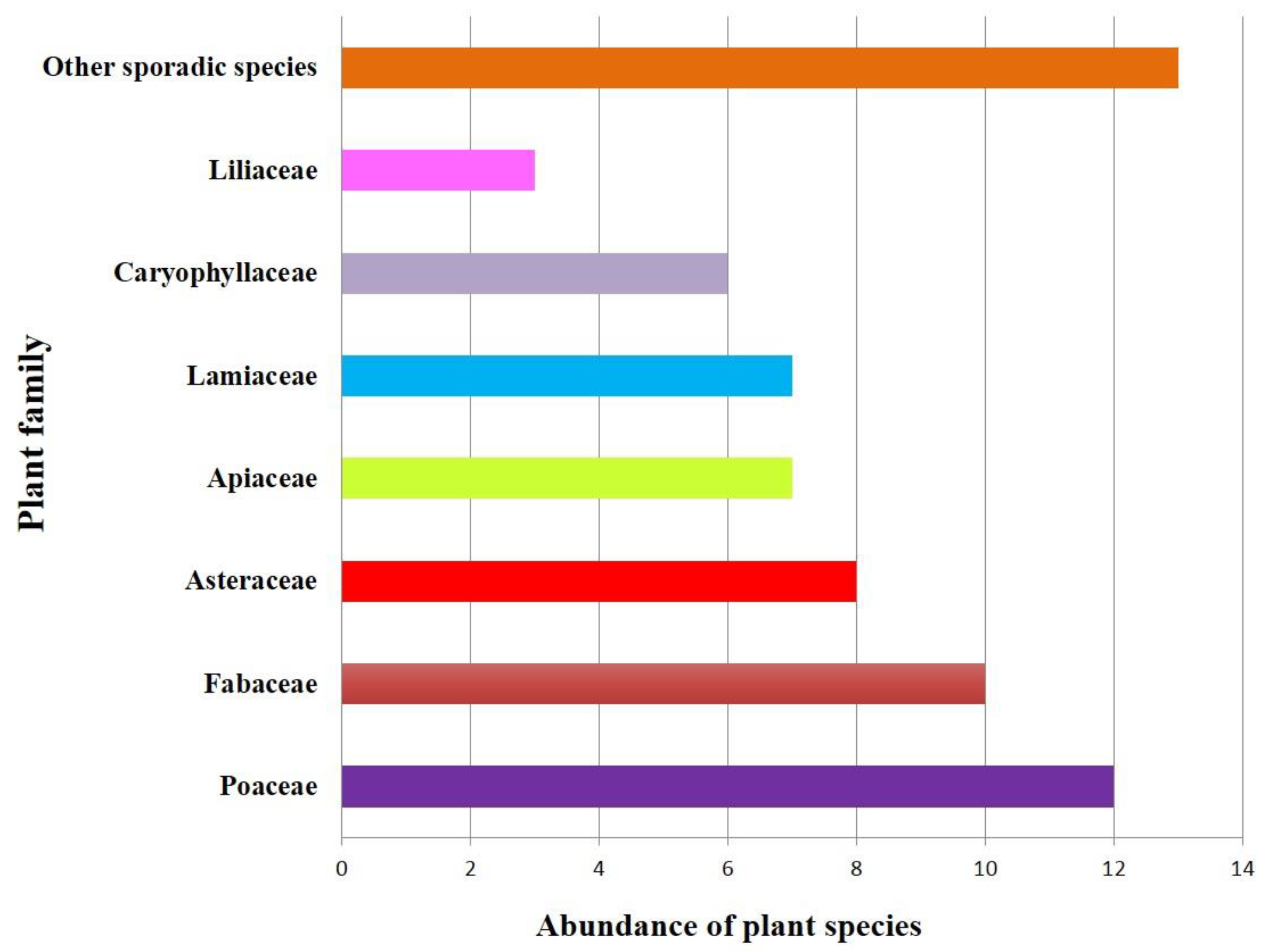
The investigation and identification of the region’s vegetation revealed 66 vascular plant species, belonging to 51 genera and 18 families. The most important families in terms of species abundance were Poaceae with 12 species (18.2%), Fabaceae with 10 species (15.2%), Asteraceae with 8 species (12.1%), Lamiaceae with 7 species (10.6%), Apiaceae with 7 species (10.6%), Caryophyllaceae with 6 species (9.1%), Liliaceae with 3 species (4.5%), and 13 sporadic species (19.7%) that belonged to other plant families (Figure 3).
In terms of life form, 66.7%, 15.1%, 10.6%, 6.1%, and 1.5% belong to hemicryptophytes, camphites, trophites, geophyte, and phanerophytes, respectively (Figure 4).

3.2. Vegetation Characteristics of the Studied Region

The species present in the study area of our interest were Bromus tomentellus, Poa bulbosa and Astragalus spp. The distribution of these species extends from 2000 to 2700 m. In particular, in the range from 2200 to 2400 m, their abundance is greater and reaches the maximum distribution around 2300 m. The average vegetation characteristics of the studied region are illustrated in Table 1.
The plant density (number of plants per hectare) of the major (dominant) species of the studied species’ habitat is illustrated in Figure 5. The canopy cover percentage of the major (dominant) species of the target species’ habitat is depicted in Figure 6.

3.3. Investigating the Ecological Requirements of A. curvirostris in the Studied Habitat

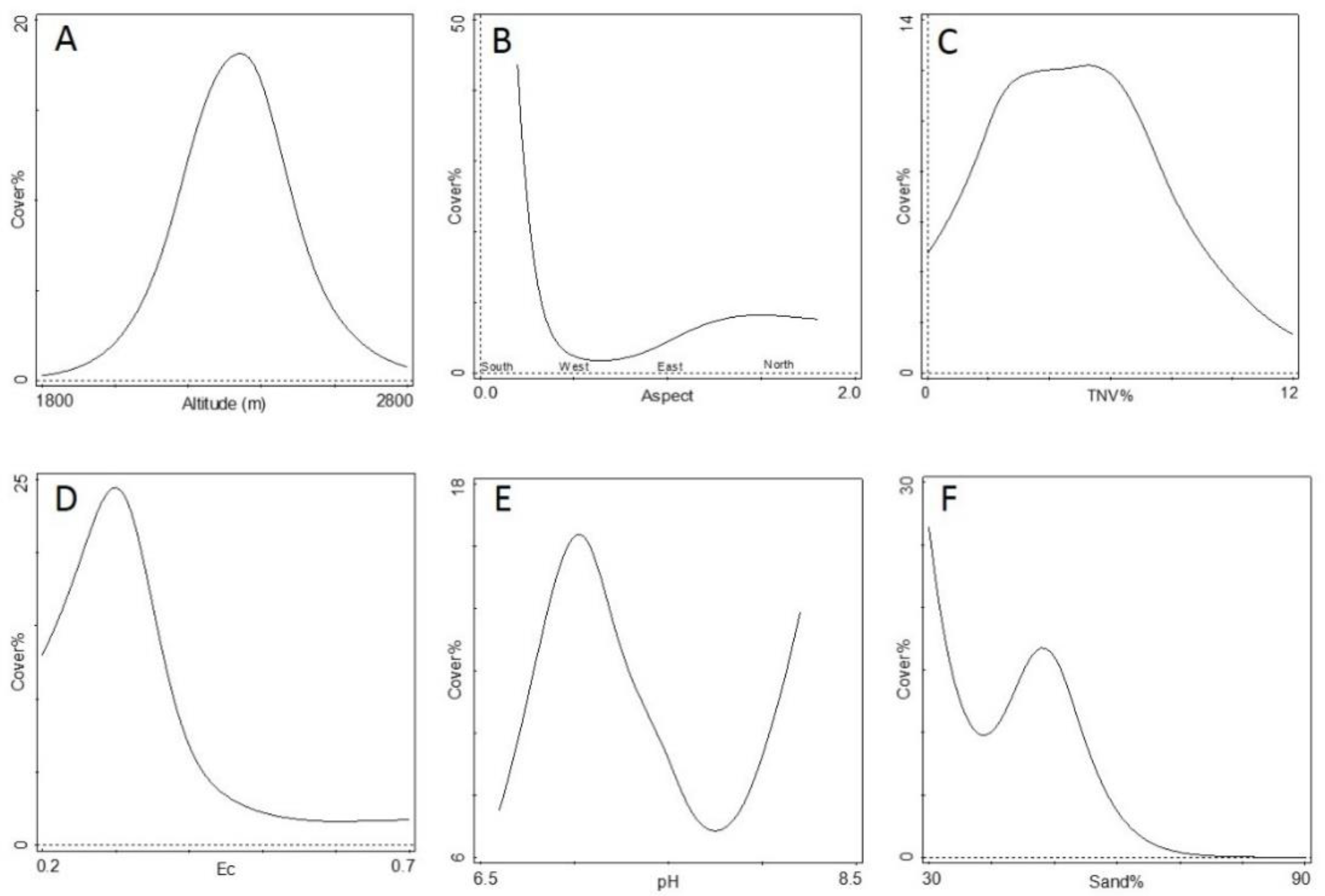
Applying the generalized additive model with the Poisson error distribution for each of the environmental variables showed that the saturated moisture percentage (SP), electrical conductivity (EC), acidity, total neutralizing value or lime percentage (TNV), soil bulk density (BD), clay percentage (Cl), sand percentage (Sa), silt percentage (Si), bare soil percentage (BS), percentage of stones and gravel on the soil surface (St), elevation from sea level (Al), and Aspect (As) significantly affected the distribution and productivity of studied species to the level of less than 0.01%. Litter percentage (Li), land slope percentage (Sl), and soil organic carbon percentage (OC) had a significant difference to the level of 5%. Variables affecting A. curvirostris distribution and productivity were ranked using the Akaike Information Criterion and are showed in Table 2. The studied species’ response curve of A. curvirostris in correspondence to each of the effective environmental factors was investigated (Figure 7, Figure 8 and Figure 9).
Studied species’ distribution, associated with the elevation from sea level variable, showed that these species’ response to altitude changes is unimodal. Increasing the elevation from sea level to 2300 m increased the species’ canopy cover percentage, while further increase in elevation resulted in a declining trend of canopy cover percentage. The presence of these species in the studied area started at 2000 m and continued up to 2700 m above sea level but was not observed outside this altitude range (Figure 7A). The species showed different responses to changes in slope direction. The highest level of canopy cover was observed on the southern slope and the lower limit of these species’ presence was observed on the western slope (Figure 7B).
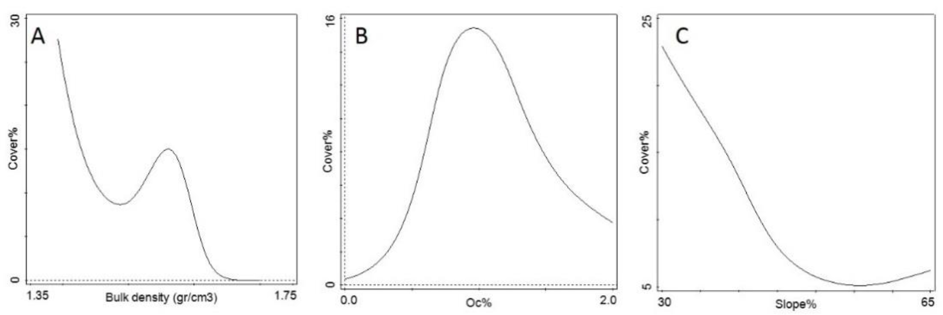
Furthermore, increased slope leads to the steady decrease of the species’ canopy cover percentage and soil slope higher than 50% results in an extreme reduction of distribution and species presence (Figure 9C). Maximum canopy cover was observed in soils with 2–6% lime content (Figure 7C). Increases in soil salinity up to 0.3 ds/m resulted in an increasing trend of canopy cover and further increases led to the reduction of canopy cover, while soil salinity above 0.5 ds/m resulted in a drastic reduction of canopy cover (Figure 7D).
The species’ response to changes in soil acidity (pH) was bimodal. The increase of soil pH up to 7 results in increased canopy cover percentage, while increases in soil pH from 7 to 8 led to the reduction of canopy cover; however, further increases in pH increased the canopy cover percentage. The lower limit of the species’ presence was observed at pH 7.6 (Figure 7E).
The species reaction to soil clay percentage, level of saturated moisture, and amount of litter on the soil surface followed a positive trend. Increasing these factors led to an increment in the canopy cover (Figure 8D,E). The response of the species was negative to increases to soil sand percentage, percentage of bare soil, and percentage of stone and pebble on the soil surface (Figure 8C and Figure 9A). Increasing soil organic carbon percentage up to 1% resulted in an increase in the canopy cover percentage of the target species while further increases of this variable led to the reduction of canopy cover (Figure 9B).

3.4. Growth Stages of A. curvirostris in Zanjan Province

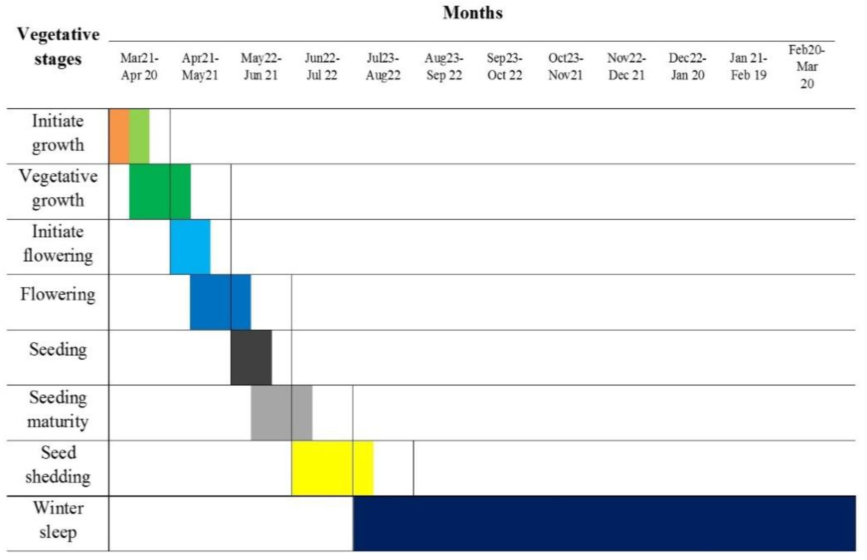
The results over two years, obtained from studying the phenology of A. cuvirostris, showed that the growth of the species begins in the last 10 days of March when the weather gradually becomes warmer, and its vegetative growth accelerates from mid-April with the increase of environment temperature. Initial flowering usually begins in the last ten days of April and continues for thirty days (up to the last 10 days of May). Seed formation begins from 22 May, and the seed maturing stage continues up to the last 10 days of June, based on the duration of the flowering stage. Seed shedding usually begins from the end of June and continues up to late July. The plant’s vegetative cycle reaches its minimum in late July and enters the overwintering stage (Figure 10).

4. Discussion

From a rangeland management point of view, plants with forage, medicinal, industrial, and protective value are of great importance [33,34,35,36,37,38,39]. These species are adapted to their environmental conditions and, with wise management, can be utilized in a supported environment [40]. On the other hand, the proper, efficient management of every region relies on accurate knowledge of the quantitative and qualitative characteristics of the region’s flora. Introducing the vegetative elements of a region is especially important in determining and properly using its vegetative potentials [41].
Studying the vegetation revealed that 54.6% of the species present in the A. curvirostris habitat belong to the Poaceae, Fabaceae, Lamiaceae, and Apiaceae families [42,43,44,45]. This indicates the relatively high potential of the studied habitat for the production of forage and medicinal plants. The Poaceae, Apiaceae, and Fabaceae families produce forage plants for livestock consumption and play a role in soil and water conservation in rangelands. The Lamiaceae family produces medicinal plants, while the Fabaceae family plays a role in soil fertility through the process of nitrogen biofixation, thus having a special place in rangelands and pastures [46]. The Asteraceae family accounts for approximately 12.1% of the studied habitat’s vegetative elements. It appears that the abundance of certain species of this family in the studied habitat is indicative of destructive human activities. However, the members of this family are well adapted to the region’s climatic conditions (part of the Iranian-Turanian region) and usually increase in highly devastated regions [47]. By investigating the life form of the species, present in the habitat, it became evident that hemicryptophytes are the dominant vegetative form, camphites rank second, and trophites are in third place. Hemicryptophytes being the dominant life form indicates the compatibility of these life forms with the climate of the studied habitat (a cold and mountainous climate) [48]. Camphites rank second in terms of the number of species. Camphite life forms are usually more tolerant against drought and livestock grazing [27], which could be one of the reasons for these plants’ dominance in the studied region. Recent droughts and the short growing season probably had an effect on trophite abundance. The excessive exploitation and factors such as human interference are among the reasons for the reduction in perennial plant abundance with the increase in opportunity for the development of annual plants [49].
The productivity of the studied species, associated with the elevation from sea level variable, showed that that the species’ response follows a unimodal model. The presence of these species began from 2000 m in the studied region and continued up to 2700 m above sea level and was not observed outside this latitude range. The highest level of canopy cover was observed in the southern direction and the lower limit of these species’ presence was observed in the western direction. Geographical direction plays an important role in plant distribution and on the amount of light, water, and nutrients available [50]. Since the southern directions are more affected by light and have more evapotranspiration, it can be said that this species is a heliophyte and drought-resistant plant. Furthermore, increased slope led to the steady decrease of the species’ percentage of canopy cover, where slopes higher than 50% resulted in an extreme limitation of canopy cover and species presence (the species’ response followed a monotonic decrease model). In steep lands, the possibility of water infiltration is low, and soil formation is slower in the long run; therefore, the conditions for the establishment of these species are not provided, a topic that Harris (2002) also mentioned. Therefore, terrain and climate-related factors are influential on the distribution of the studied species, which is consistent with the findings of previous researchers [48,51,52,53,54,55].
On the other hand, results showed that the studied species had maximum canopy cover in soil with a 2–6% lime content (the species’ response followed a unimodal model). Lime increases soil alkalinity and provide a source of calcium and magnesium for the plants, while also increasing water retention in the soil. The sum of these factors is influential on the distribution and presence of the species in the regions [56,57]. Despite the fact that soil salinity is not an issue in mountainous rangelands, it was observed that its increase up to 0.3 ds/m resulted in an increasing trend of the species’ canopy cover, while salinities over 0.5 ds/m resulted in a drastic reduction of canopy cover. According to the study’s results, the species’ response to soil pH was combinational. Therefore, increasing soil pH up to 7 results in an increased percentage of canopy cover, while increasing soil pH from 7 to 8 leads to the reduction of canopy cover, and increases in soil pH above 8 result in further growth of the canopy cover percentage. The lower limit of the species’ presence was observed at a soil acidity of 7.6. Soil acidity affected plant growth, directly or indirectly, and its most important role was controlling the solubility of nutrients in the soil. In other words, nutrient absorbability is largely dependent on this factor. Nutrients show different levels of solubility at various pH levels, which could therefore be deemed a factor in the distribution of species in the region. In this regard, Chaplygin and colleagues [51] also introduced electrical conductivity and soil pH as factors that influence the distribution of Artemisia fragrans and Artemisia austrica in the studied regions. The species responded differently to soil texture. These species showed better compatibility in clay-loam soils, compared to sand-loam soils. Maximum species productivity and presence were observed in soils with a clay-loam texture and minimum presence was observed in sand-loam soils. The species’ response to the moisture saturation level and the amount of leaf litter on the soil surface showed a positive trend. The species’ canopy cover grew with increases in these factors but the response to an increase of stones and pebbles on the soil surface, as well as the percentage of bare soil, showed a negative. This confirms the importance of soil moisture and texture on the distribution and presence of the species in the studied habitat. In addition to impacting nutrient absorption, permeability, and ventilation, soil texture also affects the level of moisture available to plants and plays an important role in the distribution of various species [58,59]. The optimum value for species productivity was observed in areas where the soil’s organic carbon percentage fell in the 0.8–1.2% range. In this regard, Chesworth [60] believes that improving the soil’s organic carbon content increases crop production and restores the soil and biomes.
One of the major issues of Iran’s rangelands is the lack of attention to the phenological stages of plant species that leads to the improper and premature exploitation of the natural forage of rangelands. By recognizing and understanding the phenological stages of dominant and key species, the necessary steps could be taken towards planning proper management programs, including rangeland grazing management and determining the proper moment for seed collection, which will result in the conservation, improvement, and restoration of rangelands. According to the results obtained from this study and other’s [61,62,63], the phenological stages of the target species and the accompanying dominant species, as well as the soil moisture status of the studied habitat, late-May is suggested as the optimum time for the entrance of livestock to the studied rangeland. This is because most Poaceae members of the region have entered the panicle emergence stage at this time, and the key, dominant, and herbaceous broad-leaved plants of the studied region have entered the flowering stage and the land is therefore in suitable condition in terms of soil moisture. The best time for collecting the studied species’ seeds is mid-June to late-June/early-July and after this date, the species’ seeds will begin to fall and cause problems for seed collection. Knowledge of habitat environmental characteristics and ecological needs of plant species has an effective role in suggesting species that are compatible with environmental conditions in similar areas. Therefore, the results of this study can be used to conserve this species and improve and reclamation of the areas with similar conditions, which is one of the important achievements of this study.

Author Contributions

Conceptualization, F.A. and P.M.; methodology, F.A., H.M., and M.S.; investigation, F.A., H.M., and M.S.; writing—original draft preparation, F.A. and P.M.; writing—review and editing, A.M. and E.M.S.; funding acquisition, A.M. All authors have read and agreed to the published version of the manuscript.

Funding

This research received no external funding.

Institutional Review Board Statement

Not applicable.

Informed Consent Statement

Not applicable.

Data Availability Statement

The data presented in this study are available on request from the corresponding author.

Conflicts of Interest

The authors declare no conflict of interest.

References

  1. Austin, M.P. Spatial prediction of species distribution: An interface between ecological theory and statistical modelling. Ecol. Model. 2002, 157, 101–118. [Google Scholar] [CrossRef] [Green Version]
  2. Austin, M.P.; Smith, T.M. A new model for the continuum concept. Vegetatio 1989, 83, 35–47. [Google Scholar] [CrossRef]
  3. Ter Braak, C.J.F. The analysis of vegetation-environment relationships by canonical correspondence analysis. Vegetatio 1987, 69, 69–77. [Google Scholar] [CrossRef]
  4. McGill, B.J.; Enquist, B.J.; Weiher, E.; Westoby, M. Rebuilding community ecology from functional traits. Trends Ecol. Evol. 2006, 21, 178–185. [Google Scholar] [CrossRef] [PubMed]
  5. Pearson, R.G.; Dawson, T.P. Predicting the impacts of climate change on the distribution of species: Are bioclimate envelope models useful? Glob. Ecol. Biogeogr. 2003, 12, 361–371. [Google Scholar] [CrossRef] [Green Version]
  6. Guisan, A.; Theurillat, J.-P.; Kienast, F. Predicting the potential distribution of plant species in an alpine environment. J. Veg. Sci. 1998, 9, 65–74. [Google Scholar] [CrossRef]
  7. Guisan, A.; Weiss, S.B.; Weiss, A.D. GLM versus CCA spatial modeling of plant species distribution. Plant Ecol. 1999, 143, 107–122. [Google Scholar] [CrossRef]
  8. Peterson, A.T. Predicting Species’ Geographic Distributions Based on Ecological Niche Modeling. Condor 2001, 103, 599. [Google Scholar] [CrossRef]
  9. Bakkenes, M.; Alkemade, J.R.M.; Ihle, F.; Leemans, R.; Latour, J.B. Assessing effects of forecasted climate change on the diversity and distribution of European higher plants for 2050. Glob. Chang. Biol. 2002, 8, 390–407. [Google Scholar] [CrossRef]
  10. Moisen, G.G.; Frescino, T.S. Comparing five modelling techniques for predicting forest characteristics. Ecol. Model. 2002, 157, 209–225. [Google Scholar] [CrossRef] [Green Version]
  11. Guisan, A.; Zimmermann, N.E. Predictive habitat distribution models in ecology. Ecol. Model. 2000, 135, 147–186. [Google Scholar] [CrossRef]
  12. Guisan, A.; Edwards, T.C.; Hastie, T. Generalized linear and generalized additive models in studies of species distributions: Setting the scene. Ecol. Model. 2002, 157, 89–100. [Google Scholar] [CrossRef] [Green Version]
  13. Berg, Å.; Gärdenfors, U.; von Proschwitz, T. Logistic regression models for predicting occurrence of terrestrial molluscs in southern Sweden—Importance of environmental data quality and model complexity. Ecography 2004, 27, 83–93. [Google Scholar] [CrossRef]
  14. Engler, R.; Guisan, A.; Rechsteiner, L. An improved approach for predicting the distribution of rare and endangered species from occurrence and pseudo-absence data. J. Appl. Ecol. 2004, 41, 263–274. [Google Scholar] [CrossRef]
  15. Robertson, M.P.; Peter, C.I.; Villet, M.H.; Ripley, B.S. Comparing models for predicting species’ potential distributions: A case study using correlative and mechanistic predictive modelling techniques. Ecol. Model. 2003, 164, 153–167. [Google Scholar] [CrossRef] [Green Version]
  16. Austin, M.P.; Belbin, L.; Meyers, J.A.; Doherty, M.D.; Luoto, M. Evaluation of statistical models used for predicting plant species distributions: Role of artificial data and theory. Ecol. Model. 2006, 199, 197–216. [Google Scholar] [CrossRef]
  17. Abbasian, H.; Kiabi, B.H.; Kavousi, K. Food habits of Wild Goat, Capra aegagrus aegagrus, in the Khorramdasht area, Kelardasht, Iran. Zool. Middle East 2004, 33, 119–124. [Google Scholar] [CrossRef]
  18. Alavi, J.; Nouri, Z.; Zahedi, A.G. The Response Curve of Beech Tree (Fagus Orientalis Lipsky.) in Relation to Environmental Variables Using Generalized Additive Model in Khayroud Forest, Nowshahr. Wood For. Sci. Technol. Res. 2017, 24, 29–42. [Google Scholar] [CrossRef]
  19. Assadi, M.; Maassoumi, A.A.; Jamzad, Z. Flora of Iran; Research Institute of Forests and Rangelands: Isfahan, Iran, 2007; p. 24S. [Google Scholar]
  20. Modarres, R.; Sarhadi, A. Rainfall trends analysis of Iran in the last half of the twentieth century. J. Geophys. Res. 2009, 114. [Google Scholar] [CrossRef]
  21. Rechinger, K.H. Flora Iranica: Flora des Iranischen Hochlandes und der Umrahmenden Gebirge: Persien, Afghanistan, Teile von West-Pakistan, Nord-Iraq, Azerbaidjan, Turkmenistan; Akademische Druck-u. Verlagsanstalt: Graz, Austria, 1990. [Google Scholar]
  22. Davis, P.H.; Cullen, J.; Coode, M.J.E.; Mill, R.R.; Tan, K.; Guner, A. Flora of Turkey and the East Aegean Islands; University Press: Edinburgh, Scotland, 1965. [Google Scholar]
  23. Noedoost, F.; Riahi, H.; Sheidai, M.; Ahmadi, A. Distribution of Charophytes from Iran with Three New Records of Characeae (Charales, Chlorophyta). Cryptogam. Algol. 2015, 36, 389–405. [Google Scholar] [CrossRef]
  24. Kuehl, R.O.; Breckenridge, R.P.; Panda, M. Integrated response plot designs for indicators of desertification. Environ. Monit. Assess. 1995, 37, 189–209. [Google Scholar] [CrossRef] [PubMed]
  25. Cain, S.A.; Castro, G.D. Manual of Vegetation Analysis; Harper: New York, NY, USA, 1959. [Google Scholar]
  26. Eichenberger, J.K.; Parker, G.R.; Beers, T.W. A Method for Ecological Forest Sampling. Indiana AES Res. Bull. 1982, 969, 3–9. [Google Scholar]
  27. Kouba, Y.; Merdas, S.; Mostephaoui, T.; Saadali, B.; Chenchouni, H. Plant community composition and structure under short-term grazing exclusion in steppic arid rangelands. Ecol. Indic. 2021, 120, 106910. [Google Scholar] [CrossRef]
  28. Traoré, S.; Zerbo, L.; Schmidt, M.; Thiombiano, L. Acacia communities and species responses to soil and climate gradients in the Sudano-Sahelian zone of West Africa. J. Arid Environ. 2012, 87, 144–152. [Google Scholar] [CrossRef]
  29. Palmer, M.W. Putting Things in Even Better Order: The Advantages of Canonical Correspondence Analysis. Ecology 1993, 74, 2215–2230. [Google Scholar] [CrossRef]
  30. Yee, T.W.; Mitchell, N.D. Generalized additive models in plant ecology. J. Veg. Sci. 1991, 2, 587–602. [Google Scholar] [CrossRef]
  31. Godefroid, S.; Koedam, N. Interspecific variation in soil compaction sensitivity among forest floor species. Biol. Conserv. 2004, 119, 207–217. [Google Scholar] [CrossRef]
  32. Akaike, H. A new look at the statistical model identification. IEEE Trans. Autom. Control 1974, 19, 716–723. [Google Scholar] [CrossRef]
  33. Gupta, A.K.; Rather, M.A.; Kumar Jha, A.; Shashank, A.; Singhal, S.; Sharma, M.; Pathak, U.; Sharma, D.; Mastinu, A. Artocarpus lakoocha Roxb. and Artocarpus heterophyllus Lam. Flowers: New Sources of Bioactive Compounds. Plants 2020, 9, 1329. [Google Scholar] [CrossRef]
  34. Kumar, A.; Memo, M.; Mastinu, A. Plant behaviour: An evolutionary response to the environment? Plant Biol. 2020, 22, 961–970. [Google Scholar] [CrossRef]
  35. Kumar, A.; Premoli, M.; Aria, F.; Bonini, S.A.; Maccarinelli, G.; Gianoncelli, A.; Memo, M.; Mastinu, A. Cannabimimetic plants: Are they new cannabinoidergic modulators? Planta 2019, 249, 1681–1694. [Google Scholar] [CrossRef] [PubMed]
  36. Mahdavi, A.; Moradi, P.; Mastinu, A. Variation in Terpene Profiles of Thymus vulgaris in Water Deficit Stress Response. Molecules 2020, 25, 1091. [Google Scholar] [CrossRef] [PubMed] [Green Version]
  37. Mastinu, A.; Bonini, S.A.; Premoli, M.; Maccarinelli, G.; Mac Sweeney, E.; Zhang, L.; Lucini, L.; Memo, M. Protective Effects of Gynostemma pentaphyllum (var. Ginpent) against Lipopolysaccharide-Induced Inflammation and Motor Alteration in Mice. Molecules 2021, 26, 570. [Google Scholar] [CrossRef]
  38. Rad, S.V.; Valadabadi, S.A.R.; Pouryousef, M.; Saifzadeh, S.; Zakrin, H.R.; Mastinu, A. Quantitative and Qualitative Evaluation of Sorghum bicolor L. under Intercropping with Legumes and Different Weed Control Methods. Horticulturae 2020, 6, 78. [Google Scholar] [CrossRef]
  39. Reza Yousefi, A.; Rashidi, S.; Moradi, P.; Mastinu, A. Germination and Seedling Growth Responses of Zygophyllum fabago, Salsola kali L. and Atriplex canescens to PEG-Induced Drought Stress. Environments 2020, 7, 107. [Google Scholar] [CrossRef]
  40. Delfan, B.; Kazemeini, H.; Bahmani, M. Identifying Effective Medicinal Plants for Cold in Lorestan Province, West of Iran. J. Evid. Based Complement. Altern. Med. 2015, 20, 173–179. [Google Scholar] [CrossRef] [PubMed]
  41. Kwiatkowska-Malina, J. Qualitative and quantitative soil organic matter estimation for sustainable soil management. J. Soils Sediments 2017, 18, 2801–2812. [Google Scholar] [CrossRef] [Green Version]
  42. DiTomaso, J.M. Invasive weeds in rangelands: Species, impacts, and management. Weed Sci. 2000, 48, 255–265. [Google Scholar] [CrossRef] [Green Version]
  43. Demirhan, E.; ÖZyazici, M.A. Determination of Vegetation and Soil Properties of the Floodplain Rangeland in the Continental Climate Zone of Turkey. Appl. Ecol. Environ. Res. 2019, 17. [Google Scholar] [CrossRef]
  44. Khoury, C.K.; Greene, S.; Wiersema, J.; Maxted, N.; Jarvis, A.; Struik, P.C. An Inventory of Crop Wild Relatives of the United States. Crop Sci. 2013, 53, 1496–1508. [Google Scholar] [CrossRef]
  45. Gamoun, M.; Belgacem, A.O.; Louhaichi, M. Diversity of desert rangelands of Tunisia. Plant Divers. 2018, 40, 217–225. [Google Scholar] [CrossRef] [PubMed]
  46. Jafari, M.; Chahouki, M.A.Z.; Tavili, A.; Azarnivand, H.; Amiri, G.Z. Effective environmental factors in the distribution of vegetation types in Poshtkouh rangelands of Yazd Province (Iran). J. Arid Environ. 2004, 56, 627–641. [Google Scholar] [CrossRef]
  47. Nadaf, M.; Mortazavi, S.M. Investigation Flora and Life Form of Plants in Protected Region Sarigol (North Khorasan Province, Iran). Pak. J. Biol. Sci. 2010, 14, 78–81. [Google Scholar] [CrossRef] [PubMed] [Green Version]
  48. Mohebi, Z.; GHeshmati, G.A.; Sefidkon, F.; Chahouki, Z. Optimal harvest timing of Prangos ferulacea (L.) Lindl: Effects of phenology stages, elevation and type of plant factors on forage quality. J. Soil Sci. Plant Nutr. 2016, 16, 650–661. [Google Scholar] [CrossRef] [Green Version]
  49. Memariani, F.; Zarrinpour, V.; Akhani, H. A review of plant diversity, vegetation, and phytogeography of the Khorassan-Kopet Dagh floristic province in the Irano-Turanian region (northeastern Iran–southern Turkmenistan). Phytotaxa 2016, 249, 8. [Google Scholar] [CrossRef]
  50. Silva, L.C.R.; Lambers, H. Soil-plant-atmosphere interactions: Structure, function, and predictive scaling for climate change mitigation. Plant Soil 2020, 1–23. [Google Scholar] [CrossRef]
  51. Chaplygin, V.A.; Rajput, V.D.; Mandzhieva, S.S.; Minkina, T.M.; Nevidomskaya, D.G.; Nazarenko, O.G.; Kalinitchenko, V.P.; Singh, R.; Maksimov, A.Y.; Popova, V.A. Comparison of Heavy Metal Content in Artemisia austriaca in Various Impact Zones. ACS Omega 2020, 5, 23393–23400. [Google Scholar] [CrossRef]
  52. Ranjbar, A.; Vali, A.; Mokarram, M.; Taripanah, F. Investigating variations of vegetation: Climatic, geological substrate, and topographic factors—A case study of Kharestan area, Fars Province, Iran. Arab. J. Geosci. 2020, 13. [Google Scholar] [CrossRef]
  53. Zare, M.; Mohammady, M.; Pradhan, B. Modeling the effect of land use and climate change scenarios on future soil loss rate in Kasilian watershed of northern Iran. Environ. Earth Sci. 2017, 76. [Google Scholar] [CrossRef]
  54. Vetaas, O.R.; Grytnes, J.-A. Distribution of vascular plant species richness and endemic richness along the Himalayan elevation gradient in Nepal. Glob. Ecol. Biogeogr. 2002, 11, 291–301. [Google Scholar] [CrossRef]
  55. Mark, A.F.; Dickinson, K.J.M.; Hofstede, R.G.M. Alpine Vegetation, Plant Distribution, Life Forms, and Environments in a Perhumid New Zealand Region: Oceanic and Tropical High Mountain Affinities. Arct. Antarct. Alp. Res. 2018, 32, 240–254. [Google Scholar] [CrossRef]
  56. Mohtashamnia, S.; Zahedi, G.; Arzani, H. Multivariate Analysis of Rangeland Vegetation in Relation to Edaphical and Physiographical Factors. Procedia Environ. Sci. 2011, 7, 305–310. [Google Scholar] [CrossRef] [Green Version]
  57. Mseddi, K.; Al-Shammari, A.; Sharif, H.; Chaieb, M. Plant diversity and relationships with environmental factors after rangeland exclosure in arid Tunisia. Turk. J. Bot. 2016, 40, 287–297. [Google Scholar] [CrossRef]
  58. Baruch, Z. Vegetation–environment relationships and classification of the seasonal savannas in Venezuela. Flora Morphol. Distrib. Funct. Ecol. Plants 2005, 200, 49–64. [Google Scholar] [CrossRef]
  59. Friedel, J.K.; Munch, J.C.; Fischer, W.R. Soil microbial properties and the assessment of available soil organic matter in a haplic Luvisol after several years of different cultivation and crop rotation. Soil Biol. Biochem. 1996, 28, 479–488. [Google Scholar] [CrossRef]
  60. Chesworth, W.; Camps Arbestain, M.; Macías, F.; Spaargaren, O.; Spaargaren, O.; Mualem, Y.; Morel-Seytoux, H.J.; Horwath, W.R. Carbon Cycling and Formation of Soil Organic Matter. Encycl. Soil Sci. 2008, 91–97. [Google Scholar] [CrossRef]
  61. Society for Range Management. Rangeland Ecology & Management. Volume 58, Issue 1. 2005. Available online: http://www.jstor.org/journal/rangecolmana; http://www.bioone.org/loi/rama (accessed on 1 April 2005).
  62. Ahmadi, H.; Asadi, S.; Moradkhani, H. Spatial distribution and deviation from optimum temperature conditions of phenological stages of potato cultivation in West Azerbaijan. Int. J. Environ. Sci. Technol. 2018, 16, 3523–3538. [Google Scholar] [CrossRef]
  63. Schucknecht, A.; Meroni, M.; Kayitakire, F.; Boureima, A. Phenology-Based Biomass Estimation to Support Rangeland Management in Semi-Arid Environments. Remote Sens. 2017, 9, 463. [Google Scholar] [CrossRef] [Green Version]
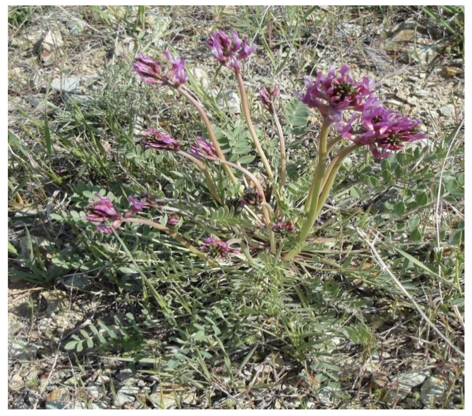
Figure 1. Astragalus curvirostris Boiss.
Horticulturae 07 00067 g001
Figure 2. Location of the study area and distribution of sample units.
Horticulturae 07 00067 g002
Figure 3. Abundance of different plant families in the areas studied.
Horticulturae 07 00067 g003
Figure 4. Abundance of plant forms (Rankier method) in the areas studied.
Horticulturae 07 00067 g004
Figure 5. Density of the dominant species in the areas studied.
Horticulturae 07 00067 g005
Figure 6. Canopy cover of dominant species in the areas studied.
Horticulturae 07 00067 g006
Figure 7. Species responses to different environment conditions. (A) altitude, (B) aspect, (C) total neutralizing value (TNV) or lime percentage, (D) electrical conductivity, (E) soil acidity, (F) sand.
Horticulturae 07 00067 g007
Figure 8. Species responses to different environment conditions. (A) clay, (B) silt, (C) stone and gravel, (D) saturated moisture percentage, (E) litter, (F) bare soil.
Horticulturae 07 00067 g008
Figure 9. Species responses to different environment conditions. (A) bulk density, (B) organic carbon, (C) soil slope.
Horticulturae 07 00067 g009
Figure 10. Phenological stages of Astragalus curvirostris Boiss in the areas studied.
Horticulturae 07 00067 g010
Table 1. Characteristics of the vegetation in the A. curvirostris habitat.
Forage Production of Target Species (kg/ha)Frequency of Target Species (%)Density of Target Species (Ha)Canopy Cover of Target Species (%)Gravel and Stones on the Soil Surface (%)Bare Soil (%)Litter (%)Total of Canopy Cover (%)
1986741,6671023183.954.9
Table 2. The results of the generalized additive model for each of the significant explanatory variables.
Environmental VariablesFP AIC
OC (%)3.030.05390.3
SP (%)13.780212.22
EC (ds/m)10.740248.49
pH10.90376.35
TNV (%)11.40374.87
BD (gr/cm3)6.080323
Cl (%)8.050273.87
Sa (%)10.10254.15
Si (%)11.650244.32
BS (%)11.990227.7
St (%)5.320333.42
Li (%)3.740.02367.13
Sl (%)3.290.04383.22
Al (m)4.960339.38
As (d)23.80336.82
Publisher’s Note: MDPI stays neutral with regard to jurisdictional claims in published maps and institutional affiliations.