
From Flood Mitigation to Environmental and Socioeconomic Disruption: A Case Study of the Langue de Barbarie Sand Spit Breach


Abstract
1. Introduction
2. The Study Area
2.1. Geographical Features of the River Senegal Estuary
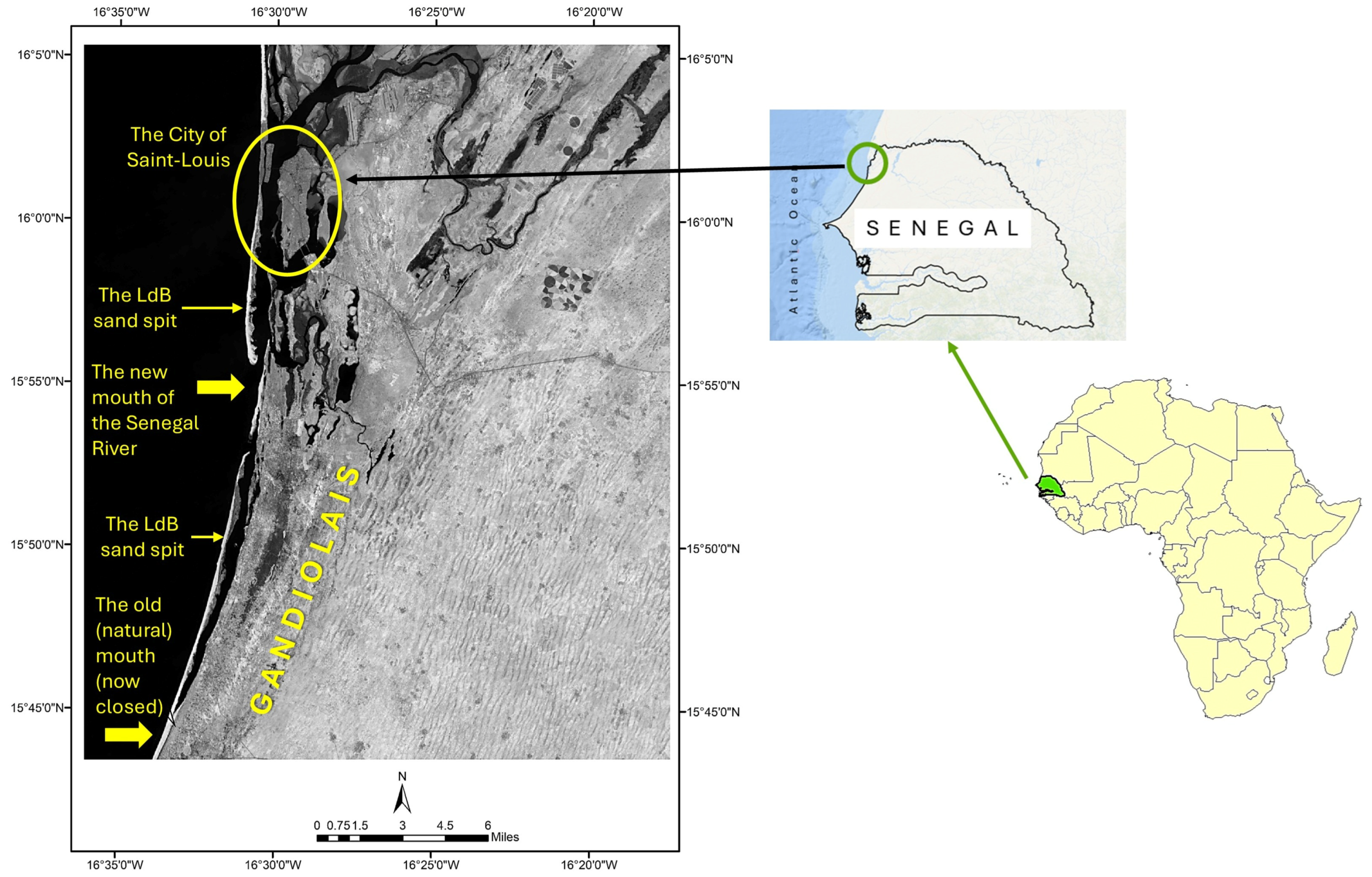
2.2. The Langue de Barbarie Sand Spit
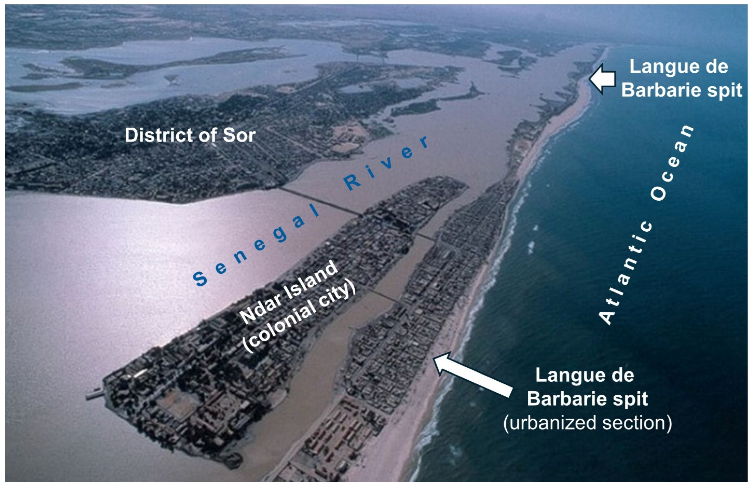
2.3. The City of Saint-Louis
- The Ndar island, also known as the colonial city, is a narrow strip of land surrounded by the Senegal River, measuring approximately 2.3 km in length and with a width that ranges from 450 to 200 m. The island barely rises above the average river level: more than 40% of the island’s area is below 1.5 m, and very low areas along the river can easily allow water to flood within the city during significant floods. The flood alert level is at 1.20 m IGN, a threshold at which the colonial city begins to flood at its northwest and northeast ends. Note that alert level heights are determined based on the current Senegalese geodetic system established by the IGN (Institut Géographique National Français) in 2006 [81].
- As described in the previous section, the Langue de Barbarie is a narrow sand spit oriented North-South, which stretches over roughly 40 km and has always served as a protective shield for the City of Saint-Louis and the entire lower Senegal delta plain.
- The District of Sor, located in the eastern part of the city, is the mainland component, comprising low-lying lands with barely perceptible altitudes close to sea level, ranging from –0.3 m to 3.5 m, and surrounded by tidal marshes.
- -
- Coastal erosion: A 2019 World Bank report estimated that coastal erosion costs the nation of Senegal more than half a billion dollars every year [89]. According to UN-Habitat, Saint-Louis is the city that is most threatened by rising sea levels in Africa. In recent years, the sand spit has been affected by sea level rise and intense coastal erosion, resulting in the shoreline’s retreat. Over the past decade, ten meters of beach have disappeared in the urbanized section of the spit. This situation is exacerbated by rapid urban growth, leading to an intensive and unplanned settlement of populations along the coastal strip, which has eliminated many sand dunes, thus considerably reducing the protective barrier function of the sand spit [57].
- -
- Recurrent flooding: Much of Saint-Louis lies at an elevation of less than 2.5 m above sea level [9,60,81]. Low areas represent 53%, of which 17% have altitudes between −1 and 0 m, and 36% emerge barely above sea level, with an elevation between 0 and 3 m [63]. Therefore, the city has always been prone to flooding that affects the lower Senegal River valley during the rainy season [66,90]. Other factors explaining the city’s exposure to floods include the low speed of floodwater evacuation associated with the silting up of the riverbed and the lengthening of the Langue de Barbarie, the backflow of river waters by marine waters during high tides, the lack of river dredging, the absence of an appropriate drainage network, the spontaneous and unplanned urbanization in flood-prone areas, the limited resources and lack of technical competence, and the rising sea level [68,91,92].
3. The Breach of the Sand Spit
3.1. Events Leading to the Breach
3.2. Evolution of the Breach
4. The Consequences
4.1. Environmental Consequences
4.1.1. Hydrological Consequences
- Reduction in flood risk: The objective for digging the channel across the spit was reached: the new mouth, which is much closer to the City of Saint-Louis, allowed for faster evacuation of floodwaters, reducing the risk of flooding in the town. Since the opening of the channel, the maximum level of the river’s floods has remained consistently below the flood level alert [81]. Moreover, the new mouth will not threaten Saint-Louis since it migrates southward, away from the city [80]. However, this came at the cost of other environmental consequences.
- Tidal amplification: The opening and subsequent widening of the breach resulted in a significant change in coastal hydrodynamics, the most notable being a substantial increase in the tidal range between the new mouth and the Diama Dam [9,63,81]. For example, the daily maximum tidal fluctuations tripled in some areas. Significant drops in river level occurred to the extent that, at low tide, it was sometimes possible to walk to the middle of the river on foot [60]. Tides now affect the lower estuary year-round, even during the rainy season, which typically coincides with the high river flow period. In the long term, such tidal patterns may undermine the wharves of Saint-Louis, the piers of Faidherbe Bridge, and the foundations of the Diama Dam [67,93].
- Salinization of water and land: Following the opening of the breach, salinity levels in both surface and groundwater rose significantly. A 77% increase in marine salinity values was observed in Saint-Louis between 2003 and 2006 [99]. The widening of the breach has exposed the lower delta directly to marine influences, considerably reducing the seasonal differences in salinity [100]. The river, now heavily influenced by marine tides, experiences saline intrusion for most of the year [51]. Samplings of water from wells in the Gandiolais indicated a significant increase in groundwater salinity between 2005 and 2012, while plots located near the Senegal River recorded salt concentrations up to 2 g/L [51,67]. This sharp increase in salinity levels in the Gandiolais is enabled by a highly porous environment that facilitates exchanges between freshwater and saltwater [101]. The salinization of land and water has contaminated the thin layer of freshwater, made most of the western Gandiolais unsuitable for agriculture, and considerably reduced access to freshwater [80,101].
4.1.2. Geomorphological Changes
- Changes to river mouthsThere were two notable changes:
- -
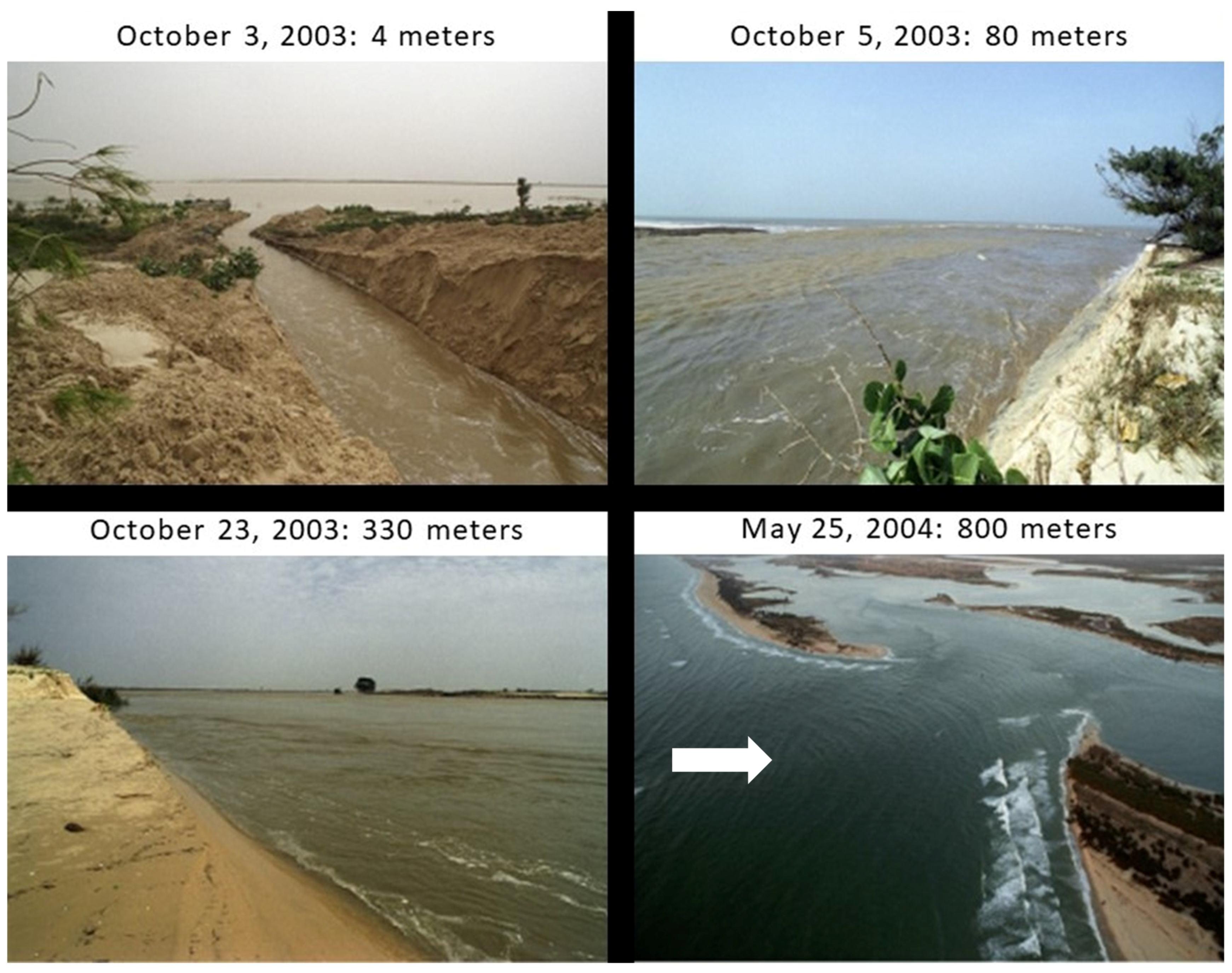
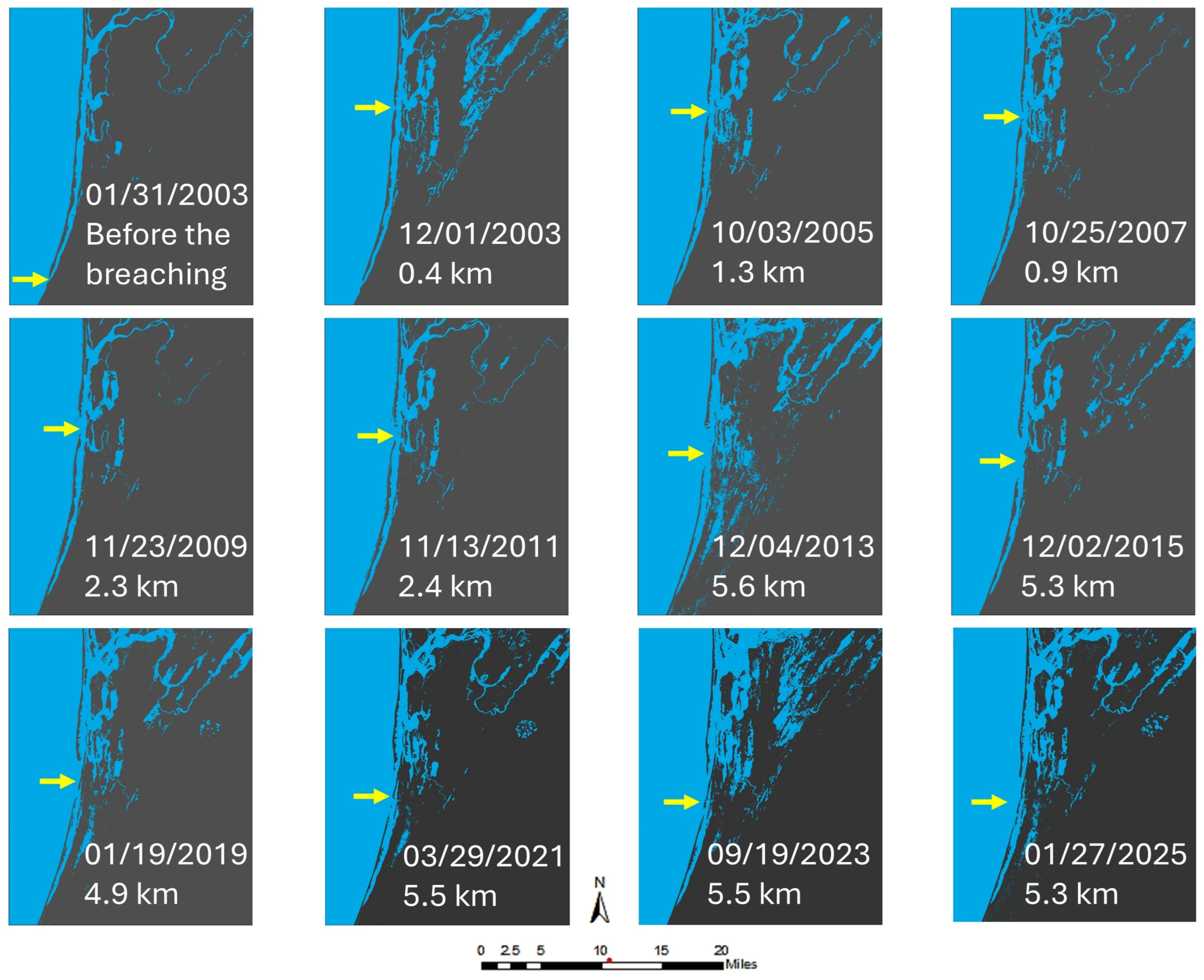
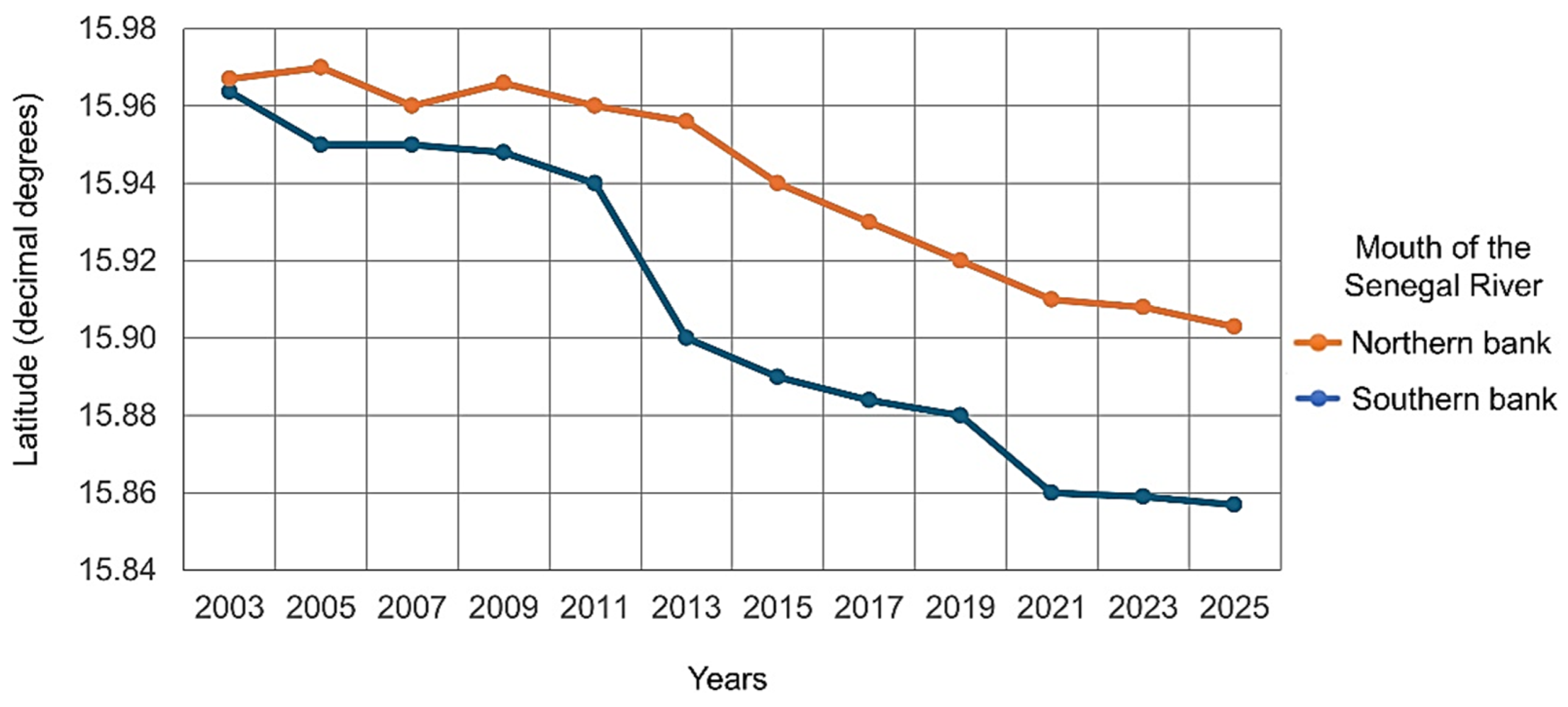
- Creation and widening of the new mouth: The opening of the breach constituted a substantial alteration in the Langue de Barbarie’s configuration. In a brief period, the river’s mouth had relocated 30 km northward and was now situated only 7 km south of Saint Louis. The 4-m-wide canal, which was opened in October 2003, widened rapidly due to heavy flood discharge and sediment erosion, reaching 800 m in May 2004 and becoming the new mouth [9,102]. The breach further widened to more than 5 km in 2013 following an intense wave erosion of the southern section of the spit [9,84]. The new mouth has been widening and migrating southward as the northern portion of the spit is elongating while the southern part is being eroded at a much higher rate. For example, from March 2011 to August 2012, the northern part of the spit elongated at an average rate of 1.3 m per day, while the southern part retreated at an average rate of 1.9 m per day [86,103,104].
- -
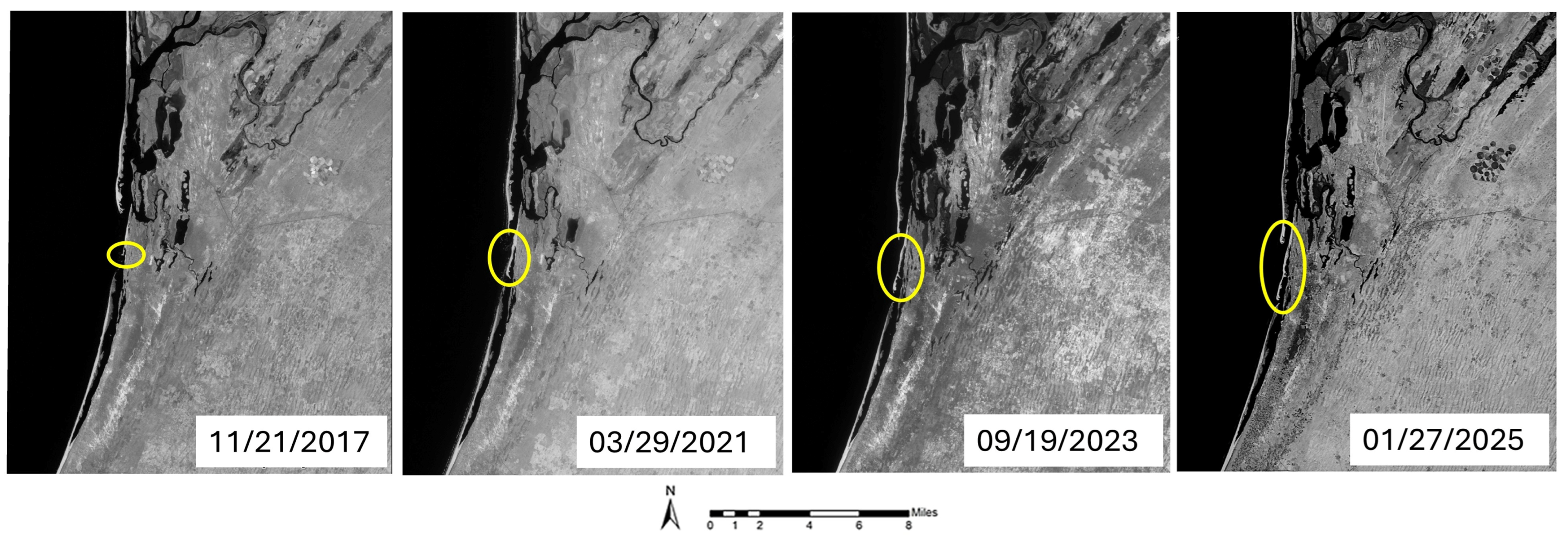
- Closure of the old river mouth: With the rapid widening of the breach, the downriver section of the river was deprived of freshwater, and materials transported by the north-south coastal drift were no longer cleared by the ebb currents, which now flow through the new mouth. The old mouth gradually silted up and narrowed from 500 m in 2003 to 5 m in 2005, eventually closing by 2006. As a result, the terminal section of the river between the old and new mouths became a lagoon with high salinity [22,101,105]. Recent satellite imagery has shown that this southern section is now almost completely sealed, thanks to the extension of a flying spit (Figure 6).
- Coastal erosion and shoreline retreat:Erosion increased dramatically after the spit breaching, leading to accelerated shoreline retreat. Ba et al. (2007) [22] cited previous studies showing that before the opening of the relief breach, shoreline retreat along the Langue de Barbarie spit varied from 1 to 2 m per year [70,75,105]. Accelerated erosion occurred after the opening of the breach, with shorelines retreating rapidly. From 2003 to 2006, the erosion rate ranged from 13 to 97 m per year [22]. Coastal erosion is sectorized and more pronounced near the new mouth. For example, from 2009 to 2012, the village island Doune Baba Dieye directly facing the new mouth experienced severe erosion as riverbanks in this area had become coastlines [80,97]. From the opening of the breach to 2010, approximately 70% of the island’s area was lost due to coastal erosion. During this period, the average erosion rates in this sector reached 18.6 m per year, compared to lower rates of 0.5 to 1.4 m per year in sectors farther from the new river mouth [103,104]. As the southern portion of the spit was being eroded and the new mouth migrated southward, new sectors of the Gandiolais would be directly exposed to waves and intense coastal erosion, hence experiencing problems like those ongoing at the current mouth location [80]. With the southward extension of the spit, the Doune Baba Dieye sector became less vulnerable to marine hazards. Between 2012 and 2016, its beaches experienced accretion at a rate of 12.5 m per year, thus demonstrating self-organization and coastal resilience [57,86].Since the opening of the new inlet, accelerated erosion, and increased marine influence have threatened “l’Ilot aux Oiseaux” (Birds Island), a small Senegal River island that is a critical habitat for birds nesting located in the Langue de Barbarie National Park. Strong tidal currents have eroded the island’s banks, resulting in the loss of 20% of its area between 2003 and 2007 [47]. In addition, at low tide, the island’s current extent represents only 39% of its area before the breaching of the spit. This surface is reduced to 16% at high tide [106].
- Erosion of dunes:Entire dunes along the Langue de Barbarie have disappeared due to the combined effects of waves, wind, and a reduced sediment supply. A substantial retreat of the vegetated dunes occurred between September 2008 and May 2010 [92]. The degradation of this coastal vegetation has resulted in increased exposure of the dune system to marine hazards [47,92].
- Accretion dynamics, sediment transport, and deposition
- -
- Accretion: The sand transported southward by longshore currents significantly contributed to the elongation of the spit, the emergence of localized accretion zones, and the reconfiguration of coastal regions [9,20]. Accretion is particularly noticeable at the northern tip of the sand spit. Taveneau et al. (2021) found that from 2015 to 2020, the average rate of sand volume transported alongshore and captured by the sand spit was approximately 230,000 m3 per year [21]. As the new mouth extended southward, areas previously exposed became more stable and experienced new accretion. For example, in the Doune Baba Dieye sector, accretion rates were estimated to be 12.5 m per year between 2012 and 2016 [86]. Accretion also occurred toward the ocean, resulting in a widening of the spit of roughly 100 m from March to December 2011, at an average rate of 10 m per month [97].
- -
- Sediment transport and deposition: The opening of the relief canal resulted in increased erosion near the breach. With the widening of the mouth, the increased energy of swells, waves, and floodwater from the Senegal River disrupted hydro-sedimentation patterns [102]. Significant alterations in sediment transport and deposition occurred because of the opening and subsequent widening of the breach. Part of the sand from the eroded spit was carried by high water flows in the seaward direction and deposited offshore in the shallow coastal areas of the outer delta [80]. Energetic waves near the breach had a major influence on the recycling of eroded sand into river-mouth bars [20,21]. The opening and subsequent widening of the breach caused substantial alterations in sediment transport and deposition. Part of the sand from the eroded spit was carried by high water flows in the seaward direction and deposited offshore in the shallow coastal areas of the outer delta [80]. Another portion of eroded sand was transported southward by longshore currents [84]. Energetic waves near the breach had a significant influence on the conversion of a portion of the eroded sand into river-mouth bars and islets [84]. As the breach migrated southward, sandbanks were formed within the channel, expanded considerably in 2011, and became barriers, reducing the impacts of incoming marine swells and allowing the Doune Baba Dieye sector to recover progressively [96,97]. Overall, the widening of the breach had turned the new mouth into a large hub for sedimentary deposits and recycling [9].
4.1.3. Ecological Impacts
- Degradation of estuarine ecosystems and loss of biodiversity: The opening and subsequent widening of the breach caused a sudden and drastic alteration of the hydrological regime. Freshwater ecosystems declined, and marine waters became more prevalent. Estuarine ecosystems were transformed into lagoon-like systems and new saline ecosystems [51,80]. The resulting increases in salinity levels have caused modifications to the amphibian environment and estuarine ecosystems, transforming habitats, disrupting the flora and fauna of several local sites in the Gandiolais region, and affecting biodiversity. These various changes have threatened the region’s biodiversity and ecosystem services [102].
- Impacts on floraPlant species generally suited to marine environments, such as coconut and palm trees, withered and/or died because they could not sustain the increased salinity [104]. This situation was exacerbated by the intensification of coastal erosion, which significantly degraded the vegetated dunes and the spit’s coastal barrier vegetation, uprooting trees along the banks, including the “filao” trees that were planted in the early 1900s to stabilize the coastal barrier [47,104]. Increased salinity and erosion have also led to substantial mangrove degradation, negatively affecting the associated ecosystems [47]. However, some salt-tolerant plant species rapidly prospered, leading to the emergence of floristic uniformity in certain areas, which resulted in a reduction of habitat diversity and undermined the resilience of the region’s ecosystem [104].
- Impacts on faunaThe region’s fauna also suffered, especially in areas that constitute wildlife sanctuaries, including the Parc National des Oiseaux (Djoudj Parc, for birds), l’Ilot aux Oiseaux (The Birds Island), and the Gueumbeul Faunal Reserve. Some freshwater species, such as fish and tortoises, have declined considerably due to the disappearance of critical habitats [102,104]. As the mouth migrates southward, Birds Island, which is a critical nesting habitat for migrating birds, is now shrinking due to erosion and may even disappear if directly exposed to ocean waves [47,102]. Conversely, the presence of marine turtles, shellfish, and oysters grew after the opening and widening of the breach [103,104].
4.1.4. Microbial and Water Quality Changes
4.2. Socioeconomic Consequences
4.2.1. Impact on Livelihoods and Economic Activities
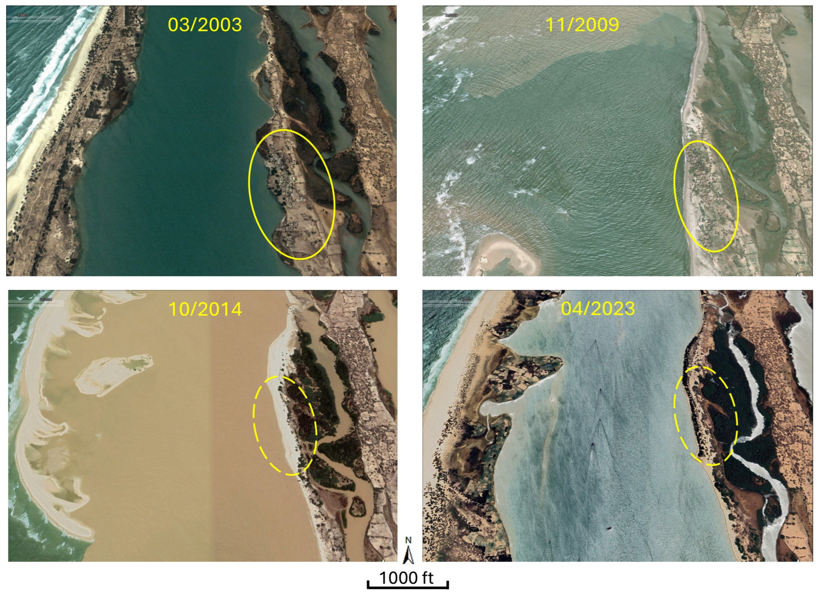
- Destruction of villagesThe widening of the new Senegal River mouth at the Langue de Barbarie triggered a rapid coastal erosion of the spit that previously protected the Gandiolais, directly exposing the local villages to intense marine swells. The village of Doune Baba Dieye exemplifies the catastrophic social, economic, and environmental consequences of the breach. Figure 7 shows the evolution of the Doune Baba Dieye area following the artificial breaching of the Barabarie spit. Between 2003 and 2007, the village’s area decreased by 8%, with significant habitat loss and damage to community buildings. By 2012, the last inhabitants had relocated, leaving behind only remnants of walls and foundations [57,80].The destruction of the village forced its inhabitants to relocate to new places. However, administrative delays, lack of suitable lands for settlement, and insufficient resources for rehousing plagued the relocation process. Since resettlement locations were further inland, fishermen had to travel longer distances to access the ocean, making fishing more challenging [104,107]. However, as accretion allowed the southward elongation of the spit and associated migration of the new river mouth, the direct impact of ocean waves on the area was significantly reduced.This change allowed sediment to accumulate, and the Doune Baba Dieye area experienced beach accretion at a rate of 12.5 m/year between 2012 and 2016. This decreased vulnerability to marine hazards demonstrated some natural resilience, and some former residents returned to the site for vegetable farming [86]. Other nearby villages were also destroyed, severely impacted, or threatened as the new mouth widened and migrated southward, including Keur Bernard, Pilote Barre, and Tassinère. As a result, many lives were disrupted, and the region’s social and economic potential was significantly undermined [103,106].
- Fishing sector declineAlthough some instances of increasing fish production immediately following the opening of the breach have been mentioned [108], the consequences of this drastic environmental change have been generally devastating for the fishing sector. The opening of the breach caused the shrinking of mangroves, which constitute vital fish breeding grounds for many fish species [109]. This loss of habitat, combined with the salinization of the Senegal River’s freshwater ecosystem, caused a sharp decline in freshwater and brackish fish species, including economically important ones like mullet, catfish, and tilapia [102,104]. As a result, the productivity of inland fishing was significantly reduced. For example, surveys conducted in the Gandiolais area showed that the daily catch per fisherman dropped from an average of 40 kg to 10 kg [47,110]. However, it is worth noting that maritime fishing experienced some growth. Data from the Saint-Louis Fisheries Service (2007) showed that from 2001 to 2006, there was a 20,000-ton increase in catches in the Gandiolais area [110].Turbulent waters at the level of the breach made its crossing dangerous for fishermen who sail daily across the new mouth to access the ocean, resulting in boat capsizing and tragic losses of life [103,104]. The disruption of fishing activities has forced families to turn to other activities, relocate, or take loans to compensate for lost income [107,109]. Given that local catches are insufficient, Gandiolais women must travel to Saint-Louis to purchase fish for salting and drying, while young fishermen migrate to other fishing centers of the country [104,110]. Aquaculture was introduced as an alternative, but its progress remains slow due to limited technical expertise [109].
- Agricultural and livestock damageThe salinization of soil and water, combined with erosion and loss of freshwater sources, adversely impacted agriculture in Gandiolais, a sector that employed 70% of the local population, according to the 2010 Local Development Plan [104].
- -
- The effects of salinization and coastal erosion: The intrusion of seawater into the Senegal River and surrounding aquifers has increased soil and groundwater salinity. As a result, the productivity and viability of agricultural lands were considerably reduced. Farmers abandoned many vegetable plots, especially those near the river, because of the high salt content in the soil and irrigation water that caused the withering or death of vegetable plants [93,109,111]. Even villages located 2–3 km inland experienced high salinity levels and associated dwindling farming opportunities. In addition, the salinization of ponds and small streams caused further freshwater shortages, reducing drinking water sources and making farming increasingly challenging [51,86,107]. The availability of arable land and fertile plots was substantially reduced because of the intensification of coastal erosion and salinization following the opening of the breach. While plots located within or near villages were not viable anymore, the nearest arable lands were now situated several kilometers away from dwellings [109]. The abandonment of agricultural land had a cascading effect on food security and the economic viability of farming [93,101].
- -
- Decline in market gardening: The opening and widening of the breach had adverse impacts on market gardening, which used to be a major source of employment and income [104,109,112]. Before the breach, farmers grew a wide variety of crops, including onions, tomatoes, potatoes, eggplants, and cabbage. As market gardening declined rapidly due to degraded land and financial constraints, many vegetable plots were no longer usable and were abandoned, as many farmers shifted to other income-generating activities, such as trading, weaving, or dyeing [104].
- -
- Reduction in crop diversity and yields: Historically, Gandiolais supported diverse agricultural production with year-round harvests of fruits and vegetables. However, after the opening of the breach, most crops could no longer tolerate the saline conditions. As a result, fruit production and annual harvests dropped significantly [102,104]. Farmers had to travel further distances to find cultivable land, increasing costs and effort [107,109]. Many farmers unable to maintain sustainable crop yields were obliged to take out loans or abandon farming altogether [101,107].
- -
- -
- Adaptation efforts: To address the challenges caused by environmental changes, some farmers have adopted new techniques, including drilling deeper wells to access fresh groundwater and installing drip irrigation systems. These investments are often funded by remittances and allow for limited diversification of crops and increased harvests. However, for many farmers, adapting to these drastic changes is difficult because they cannot afford such efforts [112].
- Tourism sector lossesTourism is an important sector of the economy in the Langue de Barbarie and the adjacent Gandiolais region. It helps diversify the local economy, constitutes a commercial advantage for local communities, and helps promote the local culture [110,113]. However, since the opening of the breach, hotels and other tourist facilities in this region have been damaged or destroyed by coastal erosion. This disruption has harmed the local economy and further contributed to population displacement [104,106].
4.2.2. Migration and Demographic Shifts
- Environmental migration: Environmental change and disasters have long been significant drivers of migration [114]. Faced with the disruption of livelihoods based on fishing, agriculture, and livestock, the Gandiolais people turned to migration as a solution to their growing problems [109,112]. Initially, migration in the Gandiolais region was circular and seasonal, as it was primarily driven by the movement of fish shoals [109]. However, the environmental and socioeconomic degradation caused by the breach changed this tradition. Many men now consider that permanent migration to support families remaining in their villages is a necessary adaptation to the decline of the region’s economy. This type of migration mainly involves young people, particularly those aged 15 to 27. Roughly 80% of this demographic group leave their villages to seek better opportunities in other Senegalese fishing centers, such as Mbour, Joal, and Kayar, or even abroad in countries like Mauritania and The Gambia [110].
- Role of remittances: Migrants often send to their families remittances that are used to improve living conditions, support farm labor, and fund income-generating activities such as crafts, transport, and building services [115,116]. In the Gandiolais region, remittances have played a major role in improving recipients’ adaptive capacity. Financial contributions sent by Gandiolais migrants have helped maintain subsistence, pay off loans, hire day laborers, purchase agricultural equipment, support daily needs, and contribute to the development of local infrastructure, such as health centers and places of worship [109,112]. Agricultural practices have particularly benefited from remittances used by local farmers to enhance their techniques by installing drip irrigation systems or drilling deeper wells to access the still-fresh groundwater. Since local insurance and credit systems have limited capacity and few farmers can access them, monetary transfers have become critical for helping reduce family risks and adapt to environmental stress [112].
4.2.3. Social and Gender Dynamics and Adaptive Strategies
- The use of remittances for agricultural innovation: Remittances sent by migrants have allowed local farmers to adopt new agricultural techniques, such as drilling deeper wells and installing drip irrigation systems, thus maintaining their activities despite the adverse impacts of the breach [112].
- The re-emergence of vegetable farming: in areas previously devastated but now recovering, like the former village of Doune Baba Dièye, families have replanted vegetables, signaling early recovery and adaptation [86].
5. Conclusions
- The dramatic evolution of the spit: The breach, initially created in 2003 for flood mitigation, resulted in a significant widening of the river mouth and a modification of the area’s geomorphology over time. This study summarizes the timeline and process of these changes based on satellite imagery and other studies.
- Severe environmental consequences: This review identified significant environmental changes resulting from the breach, including increased tidal ranges, salinization, and accelerated coastal erosion. These alterations were associated with the degradation of key ecosystems and shifts in biodiversity.
- Significant socioeconomic effects: The breach caused profound changes in local agriculture, fishing productivity, community displacement, and significantly altered the livelihoods of affected communities and migration patterns.
- Resourceful, adaptive responses: Despite the negative impacts, local communities, particularly women, have developed adaptation strategies by diversifying their economic activities, and remittances have played an important role in supporting these adaptations.
Funding
Data Availability Statement
Acknowledgments
Conflicts of Interest
References
- Goudie, A.S. Human Impact on the Natural Environment; Wiley-Blackwell: Oxford, UK, 2018; ISBN 978-1-119-40355-5. [Google Scholar]
- Gardoni, F.; Mojetta, F.; Sorrentino, C.; Etzi, R.; Gallace, A.; Bordegoni, M.; Carulli, M. Raising Awareness about the Consequences of Human Activities on Natural Environments through Multisensory Augmented Reality: Amazon Rainforest and Coral Reef Interactive Experiences. Comput.-Aided Des. Appl. 2020, 18, 815–830. [Google Scholar] [CrossRef]
- Tounta, D.D.; Nastos, P.T.; Tesseromatis, C. Human Activities and Zoonotic Epidemics: A Two-Way Relationship. The Case of the COVID-19 Pandemic. Glob. Sustain. 2022, 5, e19. [Google Scholar] [CrossRef]
- Calvin, K.; Dasgupta, D.; Krinner, G.; Mukherji, A.; Thorne, P.W.; Trisos, C.; Romero, J.; Aldunce, P.; Barrett, K.; Blanco, G.; et al. IPCC, 2023: Climate Change 2023: Synthesis Report. Contribution of Working Groups I, II and III to the Sixth Assessment Report of the Intergovernmental Panel on Climate Change; Core Writing Team, Lee, H., Romero, J., Eds.; IPCC: Geneva, Switzerland, 2023. [Google Scholar]
- Basyuni, M.; Sasmito, S.D.; Analuddin, K.; Ulqodry, T.Z.; Saragi-Sasmito, M.F.; Eddy, S.; Milantara, N. Mangrove Biodiversity, Conservation and Roles for Livelihoods in Indonesia. In Mangroves: Biodiversity, Livelihoods and Conservation; Das, S.C., Pullaiah, T., Ashton, E.C., Eds.; Springer Nature: Singapore, 2022; pp. 397–445. ISBN 978-981-19051-9-3. [Google Scholar]
- Diop, S.; Fabres, J.; Pravettoni, R.; Barusseau, J.-P.; Descamps, C.; Ducrotoy, J.-P. The Western and Central Africa Land–Sea Interface: A Vulnerable, Threatened, and Important Coastal Zone Within a Changing Environment. In The Land/Ocean Interactions in the Coastal Zone of West and Central Africa; Diop, S., Barusseau, J.-P., Descamps, C., Eds.; Estuaries of the World; Springer International Publishing: Cham, Switzerland, 2014; pp. 1–8. ISBN 978-3-319-06387-4. [Google Scholar]
- Dada, O.A.; Almar, R.; Morand, P. Coastal Vulnerability Assessment of the West African Coast to Flooding and Erosion. Sci. Rep. 2024, 14, 890. [Google Scholar] [CrossRef]
- Anthony, E.J. Patterns of Sand Spit Development and Their Management Implications on Deltaic, Drift-Aligned Coasts: The Cases of the Senegal and Volta River Delta Spits, West Africa. In Sand and Gravel Spits; Randazzo, G., Jackson, D.W.T., Cooper, J.A.G., Eds.; Coastal Research Library; Springer International Publishing: Cham, Switzerland, 2015; Volume 12, pp. 21–36. ISBN 978-3-319-13715-5. [Google Scholar]
- Sadio, M.; Anthony, E.; Diaw, A.; Dussouillez, P.; Fleury, J.; Kane, A.; Almar, R.; Kestenare, E. Shoreline Changes on the Wave-Influenced Senegal River Delta, West Africa: The Roles of Natural Processes and Human Interventions. Water 2017, 9, 357. [Google Scholar] [CrossRef]
- Ankrah, J.; Monteiro, A.; Madureira, H. Shoreline Change and Coastal Erosion in West Africa: A Systematic Review of Research Progress and Policy Recommendation. Geosciences 2023, 13, 59. [Google Scholar] [CrossRef]
- Splinter, K.D.; Harley, M.D.; Turner, I.L. Remote Sensing Is Changing Our View of the Coast: Insights from 40 Years of Monitoring at Narrabeen-Collaroy, Australia. Remote Sens. 2018, 10, 1744. [Google Scholar] [CrossRef]
- Cham, D.D.; Son, N.T.; Minh, N.Q.; Thanh, N.T.; Dung, T.T. An Analysis of Shoreline Changes Using Combined Multitemporal Remote Sensing and Digital Evaluation Model. Civ. Eng. J. 2020, 6, 1–10. [Google Scholar] [CrossRef]
- Vitousek, S.; Buscombe, D.; Vos, K.; Barnard, P.L.; Ritchie, A.C.; Warrick, J.A. The Future of Coastal Monitoring through Satellite Remote Sensing. Camb. Prisms Coast. Future 2023, 1, e10. [Google Scholar] [CrossRef]
- Boussetta, A.; Niculescu, S.; Bengoufa, S.; Zagrarni, M.F. Spatio-Temporal Analysis of Shoreline Changes and Erosion Risk Assessment along Jerba Island (Tunisia) Based on Remote-Sensing Data and Geospatial Tools. Reg. Stud. Mar. Sci. 2022, 55, 102564. [Google Scholar] [CrossRef]
- Herlekar, M.A.; Kamble, P.B.; Gawali, P.B.; Hanamgond, P.T.; Aher, S.P. Quantitative Assessment of Shoreline Changes along the Tropical West Coast, Maharashtra, India: A Remote Sensing and GIS Approach. J. Earth Syst. Sci. 2023, 132, 31. [Google Scholar] [CrossRef]
- Weerasingha, W.A.D.B.; Ratnayake, A.S. Coastal Landform Changes on the East Coast of Sri Lanka Using Remote Sensing and Geographic Information System (GIS) Techniques. Remote Sens. Appl. Soc. Environ. 2022, 26, 100763. [Google Scholar] [CrossRef]
- Specht, M.; Specht, C.; Lewicka, O.; Makar, A.; Burdziakowski, P.; Dąbrowski, P. Study on the Coastline Evolution in Sopot (2008–2018) Based on Landsat Satellite Imagery. J. Mar. Sci. Eng. 2020, 8, 464. [Google Scholar] [CrossRef]
- Papastergiadou, E.S.; Retalis, A.; Apostolakis, A.; Georgiadis, T. Environmental Monitoring of Spatio-Temporal Changes Using Remote Sensing and GIS in a Mediterranean Wetland of Northern Greece. Water Resour. Manag. 2008, 22, 579–594. [Google Scholar] [CrossRef]
- Yasir, M.; Sheng, H.; Fan, H.; Nazir, S.; Niang, A.J.; Salauddin, M.; Khan, S. Automatic Coastline Extraction and Changes Analysis Using Remote Sensing and GIS Technology. IEEE Access 2020, 8, 180156–180170. [Google Scholar] [CrossRef]
- Taveneau, A. Monitoring of Saint Louis Coast (Senegal) Using Multi-Sensor Remote Sensing Techniques. Ph.D. Thesis, Université Paul Sabatier—Toulouse III, Toulouse, France, 2023. [Google Scholar]
- Taveneau, A.; Almar, R.; Bergsma, E.W.J.; Sy, B.A.; Ndour, A.; Sadio, M.; Garlan, T. Observing and Predicting Coastal Erosion at the Langue de Barbarie Sand Spit around Saint Louis (Senegal, West Africa) through Satellite-Derived Digital Elevation Model and Shoreline. Remote Sens. 2021, 13, 2454. [Google Scholar] [CrossRef]
- Ba, K.; Wade, S.; Niang, I.; Trébossen, H.; Rudant, J.-P. Cartographie Radar En Zone Côtière à l’aide d’images Multidates RSO d’ERS-2: Application Au Suivi Environnemental de La Langue de Barbarie et de l’estuaire Du Fleuve Sénégal. Rev. Télédétect. 2007, 7, 129–141. [Google Scholar]
- Melet, A.; Teatini, P.; Le Cozannet, G.; Jamet, C.; Conversi, A.; Benveniste, J.; Almar, R. Earth Observations for Monitoring Marine Coastal Hazards and Their Drivers. Surv. Geophys. 2020, 41, 1489–1534. [Google Scholar] [CrossRef]
- Bergsma, E.W.J.; Sadio, M.; Sakho, I.; Almar, R.; Garlan, T.; Gosselin, M.; Gauduin, H. Sand-Spit Evolution and Inlet Dynamics Derived from Space-Borne Optical Imagery: Is the Senegal-River Inlet Closing? J. Coast. Res. 2020, 95, 372. [Google Scholar] [CrossRef]
- Wang, Z.; Gao, Z.; Jiang, X. Analysis of the Evolution and Driving Forces of Tidal Wetlands at the Estuary of the Yellow River and Laizhou Bay Based on Remote Sensing Data Cube. Ocean Coast. Manag. 2023, 237, 106535. [Google Scholar] [CrossRef]
- Laignel, B.; Vignudelli, S.; Almar, R.; Becker, M.; Bentamy, A.; Benveniste, J.; Birol, F.; Frappart, F.; Idier, D.; Salameh, E.; et al. Observation of the Coastal Areas, Estuaries and Deltas from Space. Surv. Geophys. 2023, 44, 1309–1356. [Google Scholar] [CrossRef]
- Klemas, V.V. Coastal and Environmental Remote Sensing from Unmanned Aerial Vehicles: An Overview. J. Coast. Res. 2015, 31, 1260–1267. [Google Scholar] [CrossRef]
- Colomina, I.; Molina, P. Unmanned Aerial Systems for Photogrammetry and Remote Sensing: A Review. ISPRS J. Photogramm. Remote Sens. 2014, 92, 79–97. [Google Scholar] [CrossRef]
- Nikolakopoulos, K.G.; Kozarski, D.; Kogkas, S. Coastal Areas Mapping Using UAV Photogrammetry. In Proceedings of the Earth Resources and Environmental Remote Sensing/GIS Applications VIII, Warsaw, Poland, 12–14 September 2017; Michel, U., Schulz, K., Eds.; SPIE: Warsaw, Poland, 2017; p. 23. [Google Scholar]
- Papakonstantinou, A.; Topouzelis, K.; Pavlogeorgatos, G. Coastline Zones Identification and 3D Coastal Mapping Using UAV Spatial Data. ISPRS Int. J. Geo-Inf. 2016, 5, 75. [Google Scholar] [CrossRef]
- Darwin, N.; Ahmad, A.; Zainon, O. The Potential of Unmanned Aerial Vehicle for Large Scale Mapping of Coastal Area. IOP Conf. Ser. Earth Environ. Sci. 2014, 18, 012031. [Google Scholar] [CrossRef]
- Sakamoto, N.; Nishiyama, S. 3D monitoring of coastal erosion control structures using UAV. Int. Arch. Photogramm. Remote Sens. Spat. Inf. Sci. 2024, XLVIII-4/W9-2024, 313–320. [Google Scholar] [CrossRef]
- Novais, J.; Vieira, A.; Bento-Gonçalves, A.; Silva, S.; Folharini, S.; Marques, T. The Use of UAVs for Morphological Coastal Change Monitoring—A Bibliometric Analysis. Drones 2023, 7, 629. [Google Scholar] [CrossRef]
- Barlow, J.; Gilham, J.; Ibarra Cofrã, I. Kinematic Analysis of Sea Cliff Stability Using UAV Photogrammetry. Int. J. Remote Sens. 2017, 38, 2464–2479. [Google Scholar] [CrossRef]
- Chen, B.; Yang, Y.; Wen, H.; Ruan, H.; Zhou, Z.; Luo, K.; Zhong, F. High-Resolution Monitoring of Beach Topography and Its Change Using Unmanned Aerial Vehicle Imagery. Ocean Coast. Manag. 2018, 160, 103–116. [Google Scholar] [CrossRef]
- Adade, R.; Aibinu, A.M.; Ekumah, B.; Asaana, J. Unmanned Aerial Vehicle (UAV) Applications in Coastal Zone Management—A Review. Environ. Monit. Assess. 2021, 193, 154. [Google Scholar] [CrossRef]
- Kandrot, S.; Hayes, S.; Holloway, P. Applications of Uncrewed Aerial Vehicles (UAV) Technology to Support Integrated Coastal Zone Management and the UN Sustainable Development Goals at the Coast. Estuaries Coasts 2022, 45, 1230–1249. [Google Scholar] [CrossRef]
- Casella, E.; Collin, A.; Harris, D.; Ferse, S.; Bejarano, S.; Parravicini, V.; Hench, J.L.; Rovere, A. Mapping Coral Reefs Using Consumer-Grade Drones and Structure from Motion Photogrammetry Techniques. Coral Reefs 2017, 36, 269–275. [Google Scholar] [CrossRef]
- Collin, A.; Ramambason, C.; Pastol, Y.; Casella, E.; Rovere, A.; Thiault, L.; Espiau, B.; Siu, G.; Lerouvreur, F.; Nakamura, N.; et al. Very High Resolution Mapping of Coral Reef State Using Airborne Bathymetric LiDAR Surface-Intensity and Drone Imagery. Int. J. Remote Sens. 2018, 39, 5676–5688. [Google Scholar] [CrossRef]
- Thomas, N.; Bunting, P.; Lucas, R.; Hardy, A.; Rosenqvist, A.; Fatoyinbo, T. Mapping Mangrove Extent and Change: A Globally Applicable Approach. Remote Sens. 2018, 10, 1466. [Google Scholar] [CrossRef]
- Islam, R.; Ahmed, R.; Dey, B.; Haque, M.S.; Aktar, S.; Bhuiyan, M.S.; Arif, M.S.; Habib Ador, M.A.; Ul Haque, M.M.; Saha, N. Salinity Hazard Drives the Alteration of Occupation, Land Use and Ecosystem Service in the Coastal Areas: Evidence from the South-Western Coastal Region of Bangladesh. Heliyon 2023, 9, e18512. [Google Scholar] [CrossRef]
- Deidun, A.; Gauci, A.; Lagorio, S.; Galgani, F. Optimising Beached Litter Monitoring Protocols through Aerial Imagery. Mar. Pollut. Bull. 2018, 131, 212–217. [Google Scholar] [CrossRef]
- Barry, K.M.; Kraus, N.C. Stability of Blocked River Mouth on West Coast of Africa: Inlet of Senegal River Estuary; Coastal and Hydraulics Laboratory (U.S.): Vicksburg, MS, USA, 2009; ERDC/CHL TR-09 20; 56p. [Google Scholar]
- Thiam, A.; Faye, P.S.; Sarr, S.M.; Diallo, D.S. Flood Management in Saint-Louis City of Senegal by Stabilizing the Breach. Am. J. Environ. Prot. 2020, 8, 70–77. [Google Scholar]
- Michel, P. The Southwestern Sahara Margin: Sediments and Climatic Changes during the Recent Quaternary. Palaeoecol. Afr. 1980, 12, 297–306. [Google Scholar]
- Diop, S.; Barusseau, J.-P.; Descamps, C. (Eds.) The Land/Ocean Interactions in the Coastal Zone of West and Central Africa; Estuaries of the World; Springer International Publishing: Cham, Switzerland, 2014; ISBN 978-3-319-06387-4. [Google Scholar]
- Kane, C. Vulnérabilité du Système Socio-Environnemental en Domaine Sahélien: L’exemple de L’estuaire du Fleuve Sénégal. De la Perception à la Gestion des Risques Naturels. Ph.D. Thesis, Université de Strasbourg, Strasbourg, France, 2010. [Google Scholar]
- Gac, J.-Y.; Kane, A.; Monteillet, J. Migrations de l’embouchure du fleuve Sénégal depuis 1850. Sér. Géol. 1982, 12, 73–75. [Google Scholar]
- Tricart, J. Notice Explicative de la Carte Géomorphologique du Delta du Sénégal; Memoires; Bureau de Recherches Geologiques et Minieres (BRGM): Paris, France, 1961; p. 137. [Google Scholar]
- Sall, M. Dynamique et Morphogenèse Actuelles au Sénégal Occidental. Ph.D. Thesis, Université Louis Pasteur, Strasbourg, France, 1982; 604p. [Google Scholar]
- Niang, A.; Kane, A. Morphological and Hydrodynamic Changes in the Lower Estuary of the Senegal River: Effects on the Environment of the Breach of the ‘Langue De Barbarie’ Sand Spit in 2003. In The Land/Ocean Interactions in the Coastal Zone of West and Central Africa; Diop, S., Barusseau, J.-P., Descamps, C., Eds.; Springer International Publishing: Cham, Switzerland, 2014; pp. 23–40. ISBN 978-3-319-06388-1. [Google Scholar]
- Almar, R.; Stieglitz, T.; Addo, K.A.; Ba, K.; Ondoa, G.A.; Bergsma, E.W.J.; Bonou, F.; Dada, O.; Angnuureng, D.; Arino, O. Coastal Zone Changes in West Africa: Challenges and Opportunities for Satellite Earth Observations. Surv. Geophys. 2022, 44, 249–275. [Google Scholar] [CrossRef]
- Demarée, G.R. An Indication of Climatic Change as Seen from the Rainfall Data of a Mauritanian Station. Theor. Appl. Climatol. 1990, 42, 139–147. [Google Scholar] [CrossRef]
- Hubert, P.; Carbonnel, J.P.; Chaouche, A. Segmentation Des Séries Hydrométéorologiques—Application à Des Séries de Précipitations et de Débits de l’afrique de l’ouest. J. Hydrol. 1989, 110, 349–367. [Google Scholar] [CrossRef]
- Hubert, P.; Bader, J.-C.; Bendjoudi, H. Un Siècle de Débits Annuels Du Fleuve Sénégal. Hydrol. Sci. J. 2007, 52, 68–73. [Google Scholar] [CrossRef]
- Diop, I. Canal de Délestage de la crue de 2003: Impacts et Perspectives; Académie des Sciences du Sénégal: Dakar, Senegal, 2004; p. 12. [Google Scholar]
- Sambou, D.; Mbaye, M.L.; Fall, A.C.A.L.; Diallo, M.A. Vulnérabilité des Sociétés et des Milieux Côtiers et Estuariens d’Afrique de L’Ouest; L’Harmattan: Ziguinchor, Sénégal, 2019; pp. 421–434. [Google Scholar]
- Ndour, A.; Ba, K.; Almar, A.; Almeida, P.; Sall, M.; Diedhiou, P.M.; Floc’h, F.; Daly, C.; Grandjean, P.; Boivin, J.-P.; et al. On the Natural and Anthropogenic Drivers of the Senegalese (West Africa) Low Coast Evolution: Saint Louis Beach 2016 COASTVAR Experiment and 3D Modeling of Short-Term Coastal Protection Measures. J. Coast. Res. 2020, 95, 583. [Google Scholar] [CrossRef]
- Sy, B.A.; Bodian, A.; Sy, A.; Faye, C.A.T. Rôle de la brèche ouverte sur la Langue de Barbarie dans la mutation de l’aléa inondation à Saint-Louis du Sénégal, cas du Faubourg de Sor. Rev. Géographie Lab. Ïdi 2013, 2515, 362–375. [Google Scholar]
- Sall, M. Crue et Élévation Du Niveau Marin à Saint-Louis Du Sénégal: Impacts Potentiels et Mesures d’adaptation. Ph.D. Thesis, Université du Maine, Le Mans, France, 2006. [Google Scholar]
- Monteillet, J. Environnements Sédimentaires et Paléoécologie du Delta du Sénégal au Quaternaire: Évolution d’un Écosystème Fluvio-Marin Tropical au cours des Derniers 100.000 ans; Université, laboratoire de recherches de sédimentologie marine: Perpignan, France, 1986. [Google Scholar]
- Sy, B.A. Le delta du fleuve Sénégal: Paysages et dynamique actuelle. In Le Delta du Fleuve Sénégal: Un Atlas Collaboratif; IRD-LGB: Paris, France, 2022; pp. 35–44. [Google Scholar]
- Kane, C.; Kane, A.; Humbert, J. Management of a Tropical River: Impacts on the Resilience of the Senegal River Estuary. In The Land/Ocean Interactions in the Coastal Zone of West and Central Africa; Diop, S., Barusseau, J.-P., Descamps, C., Eds.; Estuaries of the World; Springer International Publishing: Cham, Switzerland, 2014; pp. 41–48. ISBN 978-3-319-06387-4. [Google Scholar]
- Diakhate, M.M. Barrage de Diama et enjeux de l’aménagement du delta du fleuve Sénégal. In Le Delta du Fleuve Senegal: Atlas Collaboratif; Institut de Recherche pour le Développement IRD-UGB, Marseille (France): Marseille, France, 2022; pp. 45–50. [Google Scholar]
- Michel, P.; Barusseau, J.P.; Richard, J.F.; Sall, M. L’après Barrage Dans La Vallée Du Fleuve Sénégal; Ministère de la Coopération et du Développement, Presses Universitaires de Perpignan: Perpignan, France, 1993. [Google Scholar]
- Kane, A. L’après Barrage dans la vallée du Fleuve Sénégal: Modifications Hydrologiques, Géochimiques et Sédimentologiques. Conséquences sur le Milieu Naturel et les Aménagements Hydro-Agricoles; University of Dakar (UCAD): Dakar, Senegal, 1997. [Google Scholar]
- Dumas, D.; Mietton, M.; Hamerlynck, O.; Pesneaud, F.; Kane, A.; Coly, A.; Duvail, S.; Baba, M.L.O. Large Dams and Uncertainties: The Case of the Senegal River (West Africa). Soc. Nat. Resour. 2010, 23, 1108–1122. [Google Scholar] [CrossRef]
- Diaw, M.; Dia, A.M.; Wade, S.; Faye, S.; Faye, A.; Rudant, J.-P. Identification Des Espaces Inondées Dans l’estuaire et La Basse Vallée Du Fleuve Sénégal: Approche Cartographique Par Télédétection et Par Géochimie Isotopique. Sci. Change Planetaires—Secher. 2010, 21, 105–114. [Google Scholar] [CrossRef]
- Kane, C. Prevalence of the Vulnerability to Coastal Erosion: Case Study of Saint-Louis City. Egypt. J. Environ. Change 2023, 15, 27–38. [Google Scholar] [CrossRef]
- Guilcher, A.; Nicolas, J.P. Observation sur la Langue de Barbarie et les bras du Sénégal aux environs de Saint-Louis. Bull. D’Inform. Cent. Int. D’Exploit. Océans 1954, 6, 227–242. [Google Scholar]
- Barusseau, J.P. Essai d’évaluation Des Transports Littoraux Sableux Sous l’action Des Houles Entre Saint-Louis et Joal (Sénégal). Bull. Liaison Assoc. Sénégalaise Pour Etude Quat. Afr. Dakar 1980, 58, 31–39. [Google Scholar]
- Almar, R.; Kestenare, E.; Boucharel, J. On the Key Influence of Remote Climate Variability from Tropical Cyclones, North and South Atlantic Mid-Latitude Storms on the Senegalese Coast (West Africa). Environ. Res. Commun. 2019, 1, 071001. [Google Scholar] [CrossRef]
- Tricart, J. Delta du Fleuve Sénégal, Type Zonal de Delta. Bulletin de la Section de Géographie du Comité des Travaux Historiques et Scientifiques; Paris, France, 1957; pp. 289–314. [Google Scholar]
- Paul Barusseau, J.; Bǎ, M.; Descamps, C.; Salif Diop, E.; Diouf, B.; Kane, A.; Saos, J.L.; Soumaré, A. Morphological and Sedimentological Changes in the Senegal River Estuary after the Constuction of the Diama Dam. J. Afr. Earth Sci. 1998, 26, 317–326. [Google Scholar] [CrossRef]
- Kane, A. Le bassin du Sénégal à l’embouchure. Flux continentaux dissous et particulaires. Invasion marine dans la vallée du fleuve. Contribution à L’hydrologie Fluviatile et à la Dynamique Estuarienne en milieu Sahélien. Ph.D. Thesis, Université de Nancy II, Nancy, France, 1985. [Google Scholar]
- Koulibaly, C.T. A Comparative Analysis of the Vulnerability of Selected Areas of Senegal to Coastline Retreat; Pan African University: Ibadan, Nigeria, 2021. [Google Scholar]
- Anthony, E.J.; Almar, R.; Besset, M.; Reyns, J.; Laibi, R.; Ranasinghe, R.; Abessolo Ondoa, G.; Vacchi, M. Response of the Bight of Benin (Gulf of Guinea, West Africa) Coastline to Anthropogenic and Natural Forcing, Part 2: Sources and Patterns of Sediment Supply, Sediment Cells, and Recent Shoreline Change. Cont. Shelf Res. 2019, 173, 93–103. [Google Scholar] [CrossRef]
- Diakhaté, M. Dynamique Naturelle et Processus de Modélisation de La Brèche Ouverte Sur La Langue de Barbarie à Saint-Louis: Problématique et Préalables Méthodologiques. Rev. Géographie Lab. Ïde Univ. Gaston Berg. St.-Louis Senegal, 2012. Available online: https://www9.ugb.sn/revues-lsh/images/LEIDI/LEIDI10/23.%20EEN.%20Article%20Diakhat%C3%A9%20RGLL%20S%C3%A9n%C3%A9gal.pdf (accessed on 1 March 2025).
- Taïbi, A.N.; Kane, A.; Bourlet, M.; Lorin, M.; Ballouche, A. The Senegal River, a Disturbed Lifeline in the Sahel. In River Culture—Life as a Dance to the Rhythm of the Waters; Wantzen, K.M., Ed.; UNESCO Publishing: Paris, France, 2023; pp. 79–113. ISBN 978-92-3-100540-4. [Google Scholar]
- Steijn, R.C. Some Considerations on Water and Climate Change Impacts—St. Louis, Senegal; ARCADIS: Emmeloord, The Netherlands, 2011; p. 92. [Google Scholar]
- Durand, P.; Anselme, B.; Thomas, Y.-F. L’impact de l’ouverture de la brèche dans la langue de Barbarie à Saint-Louis du Sénégal en 2003: Un changement de nature de l’aléa inondation? Cybergeo 2010, 496, 1–28. [Google Scholar] [CrossRef]
- Diop, E.H.S.; Chevillotte, H. Etude des modifications intervenues entre le barrage de Diama et l’embouchure du fleuve Sénégal à partir d’images satellitaires. In L’après-Barrages dans la valleé du Fleuve Sénégal: Dodifications Hydro-Dynamiques et Sédimentologiques; Conséquences sur le Milieu et les Aménagements Hydro-Agricoles; Collection Etudes; Presses Universitaires de Perpignan: Perpignan, France, 1993; pp. 73–81. [Google Scholar]
- Le Borgne, J. La degradation actuelle du climat en Afrique entre Sahara et Équateur. In La dégradation des paysages en Afrique de l’Ouest; Richard, J.-F., Ed.; La Documentation Française-Presses Universitaires de Dakar: Senegal, 1990. [Google Scholar]
- Anthony, E.J. Wave Influence in the Construction, Shaping and Destruction of River Deltas: A Review. Mar. Geol. 2015, 361, 53–78. [Google Scholar] [CrossRef]
- Kane, A. Regulation du Fleuve Senegal et flux de matieres particulaire vers l’estuaire depuis la construction du Barrage de Diama. In Proceedings of the Sediment Budgets; IAHS Publ: Foz do Iguaçu, Brazil, 2005; Volume 292, pp. 279–290. [Google Scholar]
- Rey, T.; Fanget, C. L’inadéquation entre les temporalités côtières et le temps des décisions et des actions au Sénégal: L’exemple de la brèche de Barbarie. Territoire d’Afrique 2017, 10, 1–15. [Google Scholar]
- Kane, C.; Humbert, J.; Kane, A. Responding to Climate Variability: The Opening of an Artificial Mouth on the Senegal River. Reg. Environ. Change 2013, 13, 125–136. [Google Scholar] [CrossRef]
- World Bank Senegal—Saint-Louis Emergency Recovery and Resilience Project—Procurement Plan; World Bank: Washington, DC, USA, 2018; p. 18.
- Croitoru, L.; Miranda, J.J.; Sarraf, M.; Doumani, W.F.; Lee, J.J. The Cost of Coastal Zone Degradation in West Africa: Benin, Côte d’Ivoire, Senegal and Togo; West Africa Coastal Areas Management Program; World Bank: Washington, DC, USA, 2019; p. 52. [Google Scholar]
- Ndour, A.; Laïbi, R.A.; Sadio, M.; Degbe, C.G.E.; Diaw, A.T.; Oyédé, L.M.; Anthony, E.J.; Dussouillez, P.; Sambou, H.; Dièye, E.H.B. Management Strategies for Coastal Erosion Problems in West Africa: Analysis, Issues, and Constraints Drawn from the Examples of Senegal and Benin. Ocean Coast. Manag. 2018, 156, 92–106. [Google Scholar] [CrossRef]
- Wade, S.; Rudant, J.-P.; Ba, K.; Ndoye, B. Télédétection et Gestion Des Catastrophes Naturelles: Applications à l’étude des inondations urbaines de Saint Louis et du ravinement lié à l’érosion hydrique à Nioro-Du-Rip (Sénégal). Teledetection 2008, 8, 203–210. [Google Scholar]
- Deroin, J.-P.; Wade, S.; Dia, A. Impacts of breaching on a bar-built estuary, Example of the Senegal River new mouth monitored with satellite imagery from 2003 to 2010. Z. Geomorphol. 2012, 56, 351–370. [Google Scholar] [CrossRef]
- Mietton, M.; Dumas, D.; Hamerlynck, O.; Kane, A.; Coly, A.; Duvail, S.; Pesneaud, F.; Baba, M.L.O. Water Management in the Senegal River Delta: A Continuing Uncertainty. Hydrol. Earth Syst. Sci. Discuss. 2007, 4, 4297–4323. [Google Scholar]
- Camara, M.M.B. Impacts des Aménagements sur les Zones Littorales: L’exemple de L’ouverture de la Brèche sur la Langue de Barbarie (Grande côte du Sénégal). In Proceedings of the International Pluridisciplinary Conference “The Littoral: Challenge, Dialogue, Action”, Lille, France, 16–18 January 2008; p. 12. [Google Scholar]
- Sy, B.A. L’ouverture de la brèche de la Langue de Barbarie et ses conséquences, Approche géomorphologique. Rech. Afr. 2015, 5, 15. [Google Scholar]
- Sy, B.A.; Bilbao, I.A.; Sy, A.A.; Perez, I.S.; Valido, S.R. L’évolution de la brèche sur la Langue de Barbarie et ses conséquences potentielles. Rev. Géogr. L’Univ. Ouagadougou 2012, 69–854. [Google Scholar]
- Sy, B.A.; Bilbao, I.A.; Sy, A.A.; Perez, I.S.; Valido, S.R. Résultats du suivi 2010–2012 de l’évolution de la brèche ouverte sur la Langue de Barbarie au Sénégal et de ses conséquences. Physio-Géo 2013, 7, 223–242. [Google Scholar] [CrossRef]
- US Geological Survey. What Are Landsat 7 SLC-off Gap Mask Files? Available online: https://www.usgs.gov/faqs/what-are-landsat-7-slc-gap-mask-files?items_per_page=6&page=1 (accessed on 24 March 2024).
- Bouvy, M.; Arfi, R.; Bernard, C.; Carré, C.; Got, P.; Pagano, M.; Troussellier, M. Estuarine Microbial Community Characteristics as Indicators of Human-Induced Changes (Senegal River, West Africa). Estuar. Coast. Shelf Sci. 2010, 87, 573–582. [Google Scholar] [CrossRef]
- Chevalier, C.; Pagano, M.; Corbin, D.; Arfi, R. The Salinity Responses of Tropical Estuaries to Changes in Freshwater Discharge, Tidal Mixing and Geomorphology: Case Study of the Man-Affected Senegal River Estuary (West Africa). Mar. Freshw. Res. 2014, 65, 987. [Google Scholar] [CrossRef]
- Niang, S.; Descroix, L. Intrusion marine et minéralisation de la réserve souterraine dans le Gandiolais. In Le Delta du Fleuve Sénégal: Un Atlas Collaboratif; IRD-UGB: Paris, France, 2022; pp. 81–87. [Google Scholar]
- Sall, M. Climate Change, Adaptation Strategies and Mobility: Evidence from Four Settlements in Senegal; IIED: London, UK, 2011; ISBN 978-1-84369-832-6. [Google Scholar]
- Sy, B.; Sy, A.; Bodian, A.; Faye, C.A.T.; Niang, S.; Diop, M.; Ndiaye, M. « Brèche » Ouverte Sur La Langue de Barbarie à Saint-Louis Esquisse de Bilan d’un Aménagement Précipité; L’Harmattan: Paris, France, 2015; ISBN 978-2-343-06975-3. [Google Scholar]
- Brüning, L. Erosion côtière au Nord du Sénégal: Migrations et stratégies d’adaptation Etude de cas dans la commune rurale de Gandiol. Ph.D. Thesis, Université de Neuchâtel, Neuchâtel, Switzerland, 2022; p. 261. [Google Scholar] [CrossRef]
- Sy, A. Étude Géomorphologique Des Flèches Sableuses Du Littoral Sénégalais: Langue de Barbarie (Nord Sénégal), Pointe de Sangomar (Saloum), Presqu’île Aux Oiseaux (Casamance). Master’s Thesis, Université Cheikh Anta Diop—UCAD, Dakar, Senegal, 1982. [Google Scholar]
- Ndiaye, F. Impacts de la brèche sur le Parc National de la Langue de Barbarie (PNLB). In Le Delta du Fleuve Sénégal: Atlas Collaboratif; IRD-UGB: Paris, France, 2022; pp. 51–56. [Google Scholar]
- Lo, H.M.; Coulibaly-Tandian, O.; Sakho, P. Impacts des changements environnementaux sur les migrations humaines: Cas du Sénégal. In Impact des Changements Environnementaux sur les Migrations Humaines; Étude de cas: Sénégal et Côte d’Ivoire; UNESCO: London, UK, 2014; pp. 17–192. ISBN 978-2-917400-40-1. [Google Scholar]
- Camara, M.M.B. L’évaluation d’un Aménagement Littoral: La pêche et L’ouverture de la Brèche sur la Langue de Barbarie (Grande Côte Sénégalaise): Impact Écologique et Économique; Université Cheikh Anta Diop—UNESCO: Dakar, Senegal, 2004. [Google Scholar]
- Brüning, L. Typologie Des Conséquences de La Migration Sur Les Stratégies d’adaptation à l’érosion Côtière Au Sénégal. Population 2021, 76, 519–544. [Google Scholar] [CrossRef]
- Kane, C.; Humbert, J.; Kane, A. Modifications de l’embouchure du fleuve Sénégal: Impacts sur la vulnérabilité des sociétés du bas estuaire. Espaces Trop. 2011, 20, 315–326. [Google Scholar]
- Tine, M. Sécurité Alimentaire, Vulnérabilité Environnementale et Pratiques de Résilience en Contexte de Changement Climatique: Étude Socio-Anthropologique à Partir du cas de Ndiébène Gandiol (Saint-Louis). Ph.D. Thesis, Université Gaston-Berger, Saint-Louis, Senegal, 2020. [Google Scholar]
- Lietaer, S.; Brüning, L.; Faye, C.N. Ne pas revenir pour mieux soutenir?: Perceptions de la migration comme stratégie d’adaptation face aux changement environnementaux dans trois régions du Sénégal. Emul. Rev. Sci. Soc. 2020, 34, 97–113. [Google Scholar] [CrossRef]
- Toure, E.-O.; Casals, F.R. The Impact of Tourism on the Langue de Barbarie (Senegal River Delta). Cuad. Tur. 2013, 31, 355–358. [Google Scholar]
- McLeman, R.; Smit, B. Migration as an Adaptation to Climate Change. Clim. Change 2006, 76, 31–53. [Google Scholar] [CrossRef]
- Black, R.; Adger, N.; Amel, N.; Dercon, S.; Geddes, A.; Thomas, D. Foresight: Migration and Global Environmental Change. Future Challenges and Opportunities; The Government Office for Science: London, UK, 2011; p. 234. [Google Scholar]
- Adger, W.N.; Kelly, P.M.; Winkels, A.; Huy, L.Q.; Locke, C. Migration, Remittances, Livelihood Trajectories, and Social Resilience. AMBIO J. Hum. Environ. 2002, 31, 358–366. [Google Scholar] [CrossRef] [PubMed]

| Acquisition Date | Satellite |
|---|---|
| 31 January 2003 | Landsat 7 ETM |
| 1 December 2003 | Landsat 7 ETM |
| 3 October 2005 | Landsat 7 ETM |
| 25 October 2007 | Landsat 7 ETM |
| 23 November 2009 | Landsat 5 TM |
| 13 November 2011 | Landsat 5 TM |
| 4 December 2013 | Landsat 8 |
| 2 December 2015 | Landsat 7 ETM |
| 17 December 2017 | Landsat 7 ETM |
| 19 January 2019 | Landsat 8 |
| 29 March 2021 | Landsat 8 |
| 19 September 2023 | Landsat 8 |
| 27 January 2025 | Landsat 9 |
Disclaimer/Publisher’s Note: The statements, opinions and data contained in all publications are solely those of the individual author(s) and contributor(s) and not of MDPI and/or the editor(s). MDPI and/or the editor(s) disclaim responsibility for any injury to people or property resulting from any ideas, methods, instructions or products referred to in the content. |
© 2025 by the author. Licensee MDPI, Basel, Switzerland. This article is an open access article distributed under the terms and conditions of the Creative Commons Attribution (CC BY) license (https://creativecommons.org/licenses/by/4.0/).
Share and Cite
Fall, S. From Flood Mitigation to Environmental and Socioeconomic Disruption: A Case Study of the Langue de Barbarie Sand Spit Breach. Hydrology 2025, 12, 97. https://doi.org/10.3390/hydrology12040097
Fall S. From Flood Mitigation to Environmental and Socioeconomic Disruption: A Case Study of the Langue de Barbarie Sand Spit Breach. Hydrology. 2025; 12(4):97. https://doi.org/10.3390/hydrology12040097
Chicago/Turabian StyleFall, Souleymane. 2025. "From Flood Mitigation to Environmental and Socioeconomic Disruption: A Case Study of the Langue de Barbarie Sand Spit Breach" Hydrology 12, no. 4: 97. https://doi.org/10.3390/hydrology12040097
APA StyleFall, S. (2025). From Flood Mitigation to Environmental and Socioeconomic Disruption: A Case Study of the Langue de Barbarie Sand Spit Breach. Hydrology, 12(4), 97. https://doi.org/10.3390/hydrology12040097