Research on Remote Sensing Inversion of Total Phosphorus in East Juyan Lake Based on Machine Learning
Abstract
1. Introduction
2. Study Area and Materials
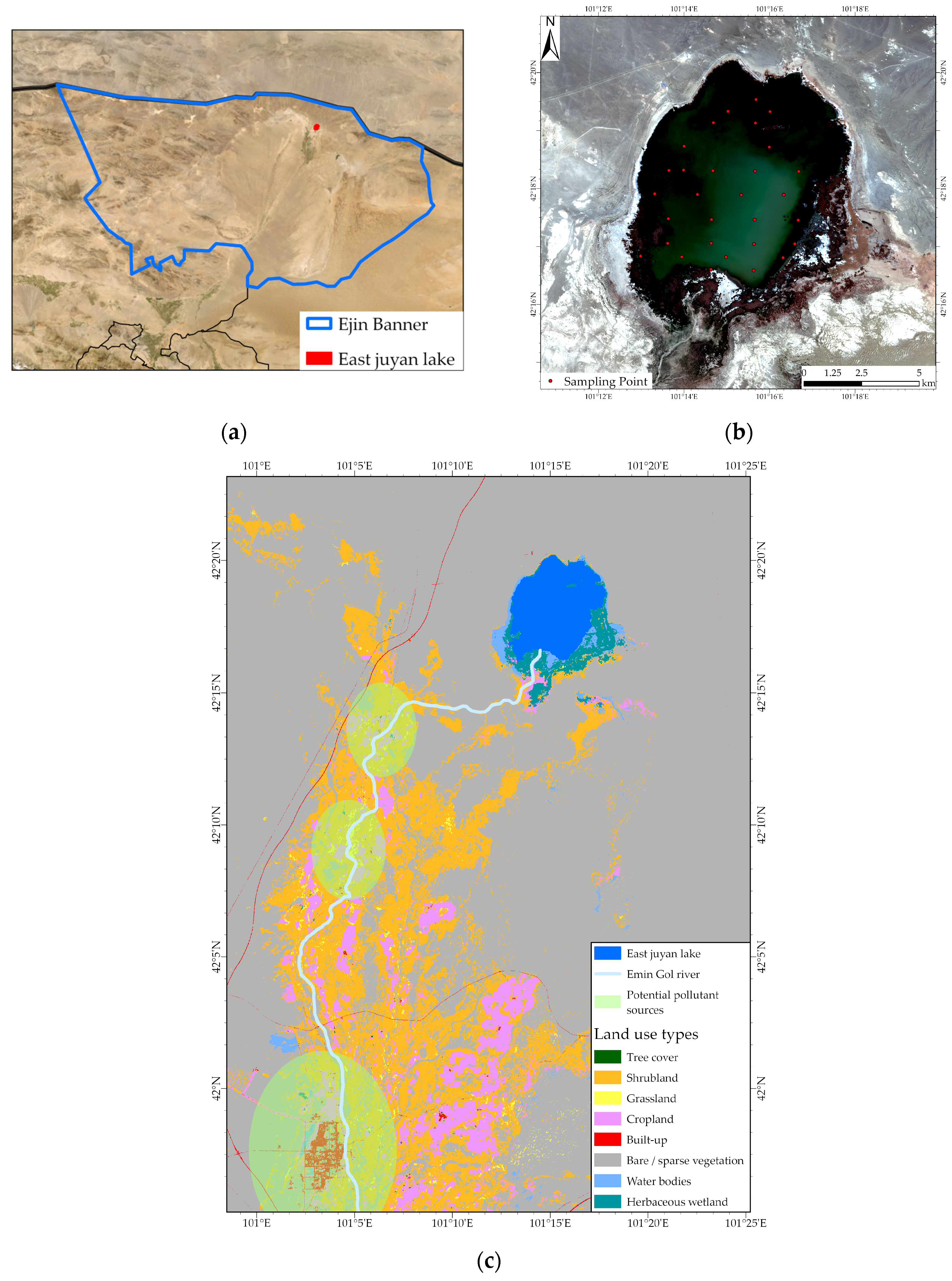
2.1. Study Area
2.2. Materials
2.2.1. Imagery Data
2.2.2. In Situ Water Quality Data
3. Methods
3.1. Band Ratio Model
3.2. Random Forest Model
3.3. Grid Search-Based XGBoost Model
3.4. Comparative Analysis of Evaluation Results
3.5. Water Quality Classification
4. Results
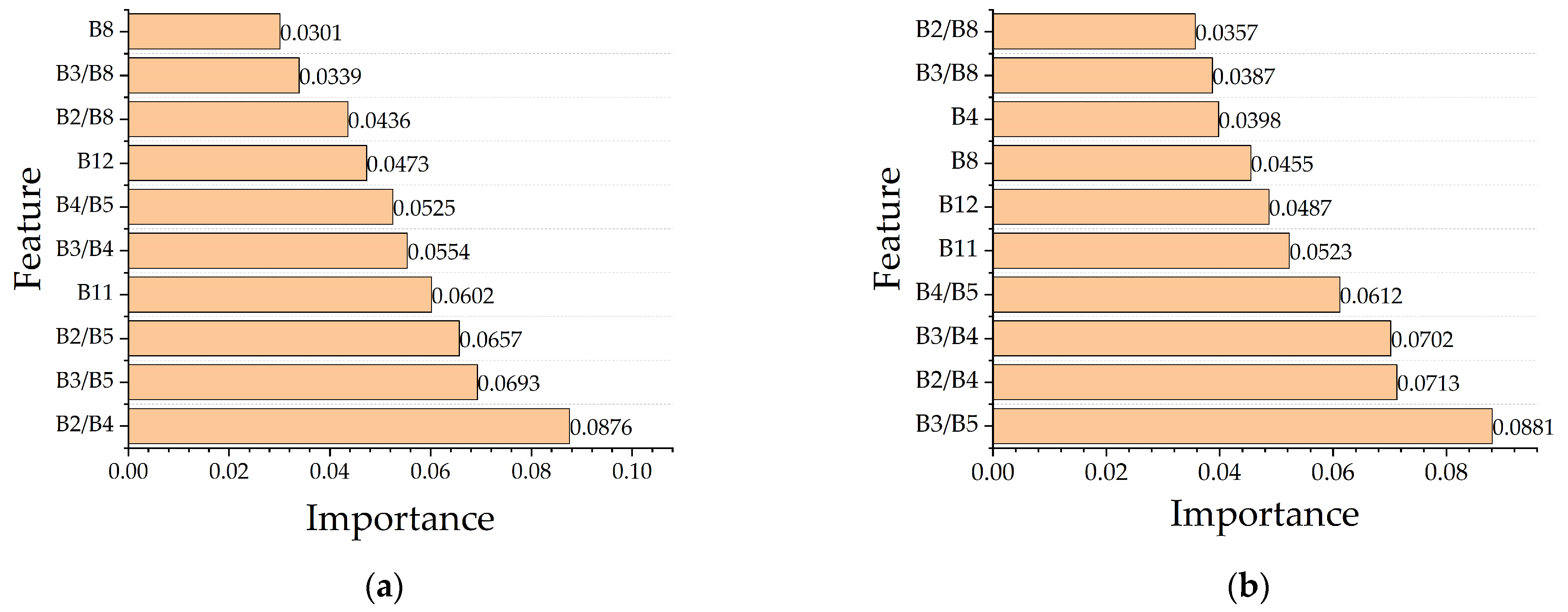
4.1. Accuracy Analysis of the 3 Inversion Methods
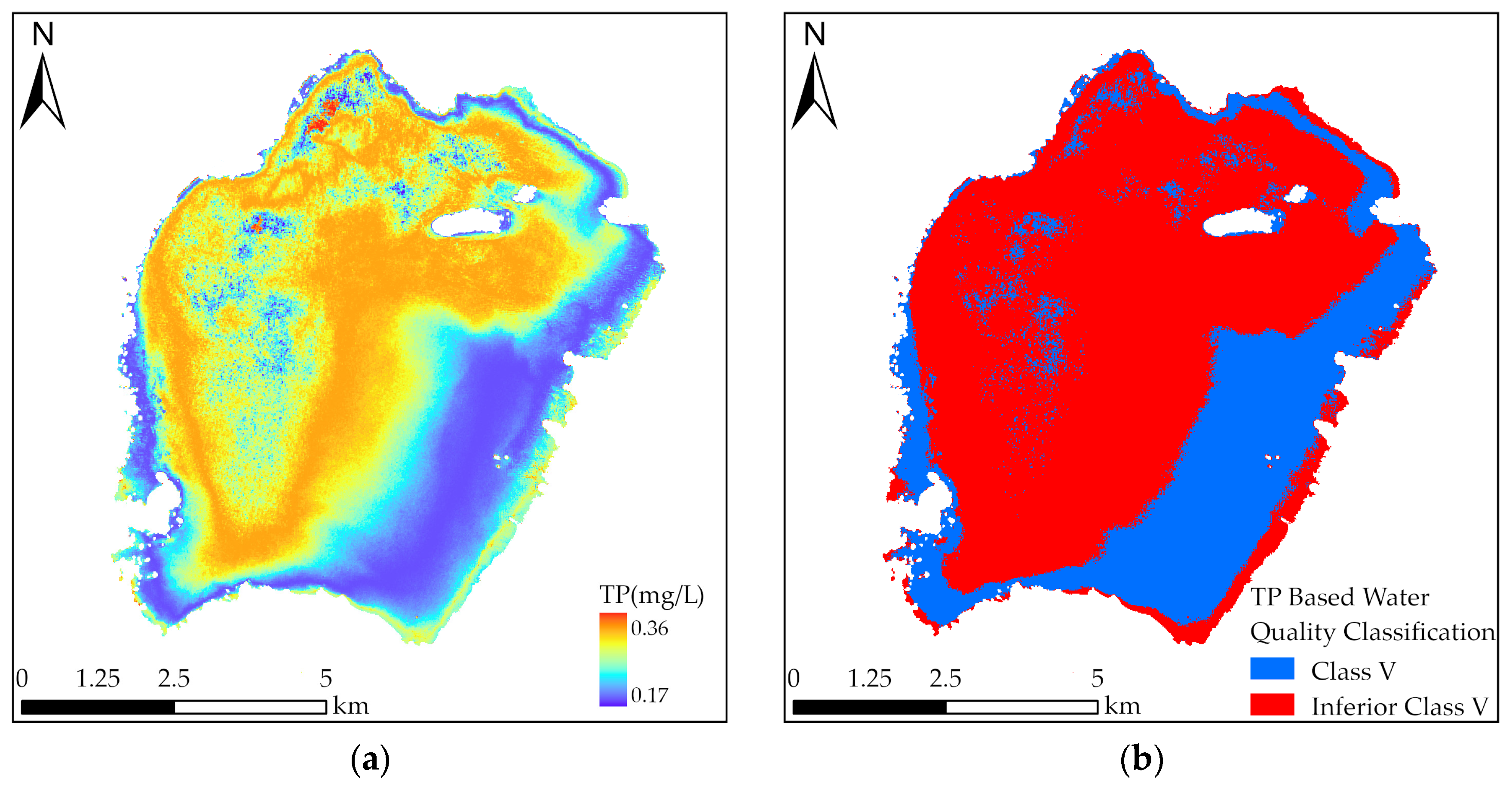
4.2. Retrieved TP Concentrations of the Study Area
5. Discussion
6. Conclusions
Author Contributions
Funding
Data Availability Statement
Conflicts of Interest
References
- Li, T.; Qiu, S.; Mao, S.; Bao, R.; Deng, H. Evaluating water resource accessibility in southwest China. Water 2019, 11, 1708. [Google Scholar] [CrossRef]
- Wang, S.; Li, J.; Zhang, B.; Lee, Z.; Spyrakos, E.; Feng, L.; Liu, C.; Zhao, H.; Wu, Y.; Zhu, L.; et al. Changes of water clarity in large lakes and reservoirs across china observed from long-term modis. Remote Sens. Environ. 2020, 247, 111949. [Google Scholar] [CrossRef]
- Duan, H.; Luo, J.; Cao, Z.; Xue, K.; Xiao, Q.; Liu, D. Progress in remote sensing of aquatic environments at the watershed scale. Prog. Geogr. 2019, 38, 1182–1195. [Google Scholar] [CrossRef][Green Version]
- Wu, C.; Wu, J.; Qi, J.; Zhang, L.; Huang, H.; Lou, L.; Chen, Y. Empirical estimation of total phosphorus concentration in the mainstream of the qiantang river in china using landsat tm data. Int. J. Remote Sens. 2010, 31, 2309–2324. [Google Scholar] [CrossRef]
- Zhao, L.; Lu, X.; Tan, H.; Ma, T. Water quality monitoring technology based on gf-1 satellite and xgboost model. Remote Sens. Inf. 2021, 36, 96–103. [Google Scholar]
- Huang, H.; Li, M.; Chen, Y.; Chen, G.; Liu, H.; Xing, Q.; Cai, J. Water quality retrieval by hyperspectral for city rivers in pearl river estuary based on partial least squares regression. Water Resour. Prot. 2021, 37, 36–42. [Google Scholar]
- Bugnot, A.B.; Lyons, M.B.; Scanes, P.; Clark, G.F.; Fyfe, S.K.; Lewis, A.; Johnston, E.L. A novel framework for the use of remote sensing for monitoring catchments at continental scales. J. Environ. Manag. 2018, 217, 939–950. [Google Scholar] [CrossRef] [PubMed]
- Wang, J.; Hu, M.; Gao, B.; Fan, H.; Wang, J. A spatiotemporal interpolation method for the assessment of pollutant concentrations in the yangtze river estuary and adjacent areas from 2004 to 2013. Environ. Pollut. (1987) 2019, 252, 501–510. [Google Scholar] [CrossRef] [PubMed]
- Lv, Y.; Guo, H.; Jin, S.; Wang, L.; Bian, H.; Liu, H. Permanganate index variations and factors in hongze lake from landsat-8 images based on machine learning. Photogramm. Eng. Remote Sens. 2022, 88, 791–802. [Google Scholar] [CrossRef]
- Lu, S.J.; Deng, R.R.; Liang, Y.H.; Xiong, L.H.; Ai, X.J.; Qin, Y. Remote sensing retrieval of total phosphorus in the pearl river channels based on the gf-1 remote sensing data. Remote Sens. 2020, 12, 1420. [Google Scholar] [CrossRef]
- Goyens, C.; Lavigne, H.; Dille, A.; Vervaeren, H. Using hyperspectral remote sensing to monitor water quality in drinking water reservoirs. Remote Sens. 2022, 14, 5607. [Google Scholar] [CrossRef]
- Chang, N.; Xuan, Z.; Yang, Y.J. Exploring spatiotemporal patterns of phosphorus concentrations in a coastal bay with modis images and machine learning models. Remote Sens. Environ. 2013, 134, 100–110. [Google Scholar] [CrossRef]
- Li, J.; Hu, C.; Shen, Q.; Barnes, B.B.; Murch, B.; Feng, L.; Zhang, M.; Zhang, B. Recovering low quality modis-terra data over highly turbid waters through noise reduction and regional vicarious calibration adjustment: A case study in taihu lake. Remote Sens. Environ. 2017, 197, 72–84. [Google Scholar] [CrossRef]
- Begliomini, F.N.; Barbosa, C.C.F.; Martins, V.S.; Novo, E.M.L.M.; Paulino, R.S.; Maciel, D.A.; Lima, T.M.A.; O’Shea, R.E.; Pahlevan, N.; Lamparelli, M.C. Machine learning for cyanobacteria mapping on tropical urban reservoirs using prisma hyperspectral data. ISPRS J. Photogramm. Remote Sens. 2023, 204, 378–396. [Google Scholar] [CrossRef]
- Liang, Y.; Ding, F.; Liu, L.; Yin, F.; Hao, M.; Kang, T.; Zhao, C.; Wang, Z.; Jiang, D. Monitoring water quality parameters in urban rivers using multi-source data and machine learning approach. J. Hydrol. 2025, 648, 132394. [Google Scholar] [CrossRef]
- Zhang, X.; Huang, J.; Chen, J.; Zhao, Y. Remote sensing monitoring of total suspended solids concentration in jiaozhou bay based on multi-source data. Ecol. Indic. 2023, 154, 110513. [Google Scholar] [CrossRef]
- Liu, X.; Zhao, T.; Cai, T.; Xiao, C.; Chen, X.; Zhang, W. Spatiotemporal monitoring of total nitrogen and ammonia nitrogen in danjiangkou reservoir. J. Agric. Resour. Environ. 2021, 38, 829–838. [Google Scholar]
- Hu, W.; Jin, S.; Zhang, Y. Water quality variations in the lower yangtze river based on ga-rf model from gf-1, landsat-8, and sentinel-2 images. IEEE J. Sel. Top. Appl. Earth Obs. Remote Sens. 2025, 18, 4992–5004. [Google Scholar] [CrossRef]
- Tan, Z.; Ren, J.; Li, S.; Li, W.; Zhang, R.; Sun, T. Inversion of nutrient concentrations using machine learning and influencing factors in minjiang river. Water 2023, 15, 1398. [Google Scholar] [CrossRef]
- Wu, H.; Guo, Q.; Zang, J.; Qiao, Y.; Zhu, L.; He, Y. Study on water quality parameter inversion based on landsat 8 and measured data. Remote Sens. Technol. Appl. 2021, 36, 898–907. [Google Scholar]
- Guo, H.; Huang, J.J.; Zhu, X.; Tian, S.; Wang, B. Spatiotemporal variation reconstruction of total phosphorus in the great lakes since 2002 using remote sensing and deep neural network. Water Res. 2024, 255, 121493. [Google Scholar] [CrossRef] [PubMed]
- Fang, C.; Song, C.; Wang, X.; Wang, Q.; Tao, H.; Wang, X.; Ma, Y.; Song, K. A novel total phosphorus concentration retrieval method based on two-line classification in lakes and reservoirs across China. Sci. Total Environ. 2024, 906, 167522. [Google Scholar] [CrossRef]
- Xiong, J.; Lin, C.; Ma, R.; Wang, X.; Xue, K.; Cao, Z.; Hu, M.; Chen, L. Remote sensing observations of phosphorus in eutrophic lakes: From concentration to storage. IEEE Trans. Geosci. Remote Sens. 2025, 63, 4203812. [Google Scholar] [CrossRef]
- Lu, J.; Li, L.; Jiang, E.; Gan, R.; Liu, C.; Deng, Y. Ecological water demand estimations for desert terminal lake survival under inland river water diversion regulation. Water 2023, 15, 66. [Google Scholar] [CrossRef]
- Copernicus Data Space Ecosystem|Europe’s Eyes on Earth. Available online: https://dataspace.copernicus.eu/ (accessed on 21 September 2025).
- Guo, H.; Huang, J.J.; Chen, B.; Guo, X.; Singh, V.P. A machine learning-based strategy for estimating non-optically active water quality parameters using sentinel-2 imagery. Int. J. Remote Sens. 2021, 42, 1841–1866. [Google Scholar] [CrossRef]
- Johnson, S.; Perumalsamy, D. Application of xgboost algorithm and grid search hyperparameter tuning to study health effects among individuals in the industrial area. Multimed. Tools Appl. 2025, 84, 34449–34492. [Google Scholar] [CrossRef]
- Tran, N.T.; Tran, T.T.G.; Nguyen, T.A.; Lam, M.B. A new grid search algorithm based on xgboost model for load forecasting. Bull. Electr. Eng. Inform. 2023, 12, 1857–1866. [Google Scholar] [CrossRef]
- GB 3838-2002; Environmental Quality Standards for Surface Water. Ministry of Ecology and Environment of the PRC: Beijing, China, 2002.


| NO. | Property | Value |
|---|---|---|
| 1 | Spacecraft Name | Sentinel-2B |
| 2 | MGRS Tile | 47TPG |
| 3 | Product ID | S2B_MSIL1C_20230818T040549_N0509_R047_T47TPG |
| 4 | Level | L1C |
| 5 | Cloudy Pixel Percentage | 0 |
| Sensing Time | 18 August 2023 04:05:49.024 GMT |
| Concentration | Measured Water Quality (mg/L) | |||
|---|---|---|---|---|
| TP | TN | CODMn | TDS | |
| Range | 0.185–0.355 | 1.74–3.45 | 11.48–18.52 | 13,410–14,630 |
| Mean | 0.228 | 2.24 | 14.55 | 13,734 |
| Standard Deviation | 0.033 | 0.34 | 1.60 | 252.43 |
| NO. | Bands Ratio | Correlation Coefficient |
|---|---|---|
| 1 | B2/B5 | 0.412 |
| 2 | B3/B5 | 0.578 |
| 3 | B4/B5 | −0.436 |
| 4 | B5/B6 | 0.378 |
| 5 | B3/B7 | 0.345 |
| 6 | B5/B8 | 0.433 |
| 7 | B6/B11 | 0.485 |
| 8 | B7/B11 | 0.476 |
| 9 | B8/B9 | −0.478 |
| 10 | B4/B11 | 0.467 |
| 11 | B3/B9 | 0.513 |
| 12 | B2/B3 | 0.505 |
| 13 | (B3 − B5)/(B3 + B5) | 0.436 |
| 14 | (B4 − B5)/(B4 + B5) | −0.453 |
| 15 | (B8 − B9)/(B8 + B9) | −0.531 |
| 16 | (B5 − B8)/(B5 + B8) | 0.485 |
| 17 | (B3 − B10)/(B3 + B10) | 0.418 |
| 18 | (B5 − B7)/(B5 + B7) | 0.385 |
| RF | Grid Search-Based XGBoost | ||
|---|---|---|---|
| Parameter | Setting Value | Parameter | Setting Value |
| N estimators | 30 | eta | 0.05 |
| max_depth | 4.00 | ||
| Max depth | 4 | reg_alpha | 0.1 |
| reg_lambda | 0.5 | ||
| gamma | 0.1 | ||
| Max features | log2 | subsample | 0.8 |
| colsample_bytree | 0.8 | ||
| n_estimators | 50.00 | ||
| Class | TP Concentrations (mg/L) |
|---|---|
| I | ≤0.01 |
| II | ≤0.025 |
| III | ≤0.05 |
| IV | ≤0.1 |
| V | ≤0.2 |
| Inferior V | >0.2 |
| Model | R2 | RMSE | MRE |
|---|---|---|---|
| Band ratio | 0.607 | 0.028 | 11.89% |
| RF | 0.734 | 0.023 | 9.78% |
| Grid Search-Based XGBoost | 0.856 | 0.017 | 7.20% |
Disclaimer/Publisher’s Note: The statements, opinions and data contained in all publications are solely those of the individual author(s) and contributor(s) and not of MDPI and/or the editor(s). MDPI and/or the editor(s) disclaim responsibility for any injury to people or property resulting from any ideas, methods, instructions or products referred to in the content. |
© 2025 by the authors. Licensee MDPI, Basel, Switzerland. This article is an open access article distributed under the terms and conditions of the Creative Commons Attribution (CC BY) license (https://creativecommons.org/licenses/by/4.0/).
Share and Cite
Zhou, Y.; Yang, W.; Hu, M.; Li, J.; Liu, X. Research on Remote Sensing Inversion of Total Phosphorus in East Juyan Lake Based on Machine Learning. Hydrology 2025, 12, 299. https://doi.org/10.3390/hydrology12110299
Zhou Y, Yang W, Hu M, Li J, Liu X. Research on Remote Sensing Inversion of Total Phosphorus in East Juyan Lake Based on Machine Learning. Hydrology. 2025; 12(11):299. https://doi.org/10.3390/hydrology12110299
Chicago/Turabian StyleZhou, Yi, Weilong Yang, Ming Hu, Junnan Li, and Xiaotong Liu. 2025. "Research on Remote Sensing Inversion of Total Phosphorus in East Juyan Lake Based on Machine Learning" Hydrology 12, no. 11: 299. https://doi.org/10.3390/hydrology12110299
APA StyleZhou, Y., Yang, W., Hu, M., Li, J., & Liu, X. (2025). Research on Remote Sensing Inversion of Total Phosphorus in East Juyan Lake Based on Machine Learning. Hydrology, 12(11), 299. https://doi.org/10.3390/hydrology12110299


