Article

Evaluating the Potential of Roof Water Harvesting System for Drinking Water Supplies During Emergencies Under the Impacts of Climate Change: ‘A Case Study of Swat District, Pakistan’

National Institute of Urban Infrastructure Planning, University of Engineering and Technology, Peshawar 25000, Pakistan
*
Author to whom correspondence should be addressed.
Standards 2025, 5(2), 11; https://doi.org/10.3390/standards5020011
Submission received: 20 November 2024 / Revised: 7 March 2025 / Accepted: 19 March 2025 / Published: 2 April 2025
(This article belongs to the Special Issue Sustainable Development Standards)

Abstract

:
It is well understood that climate change is a major cause of the environmental shifts that are significantly impacting human lives. The floods caused by climate change are not only occurring more frequently each year, but they also bring up the problem of access to clean water for drinking and other daily usage for the affected communities. The Swat district of the Khyber Pakhtunkhwa province in Pakistan is one of the impacted regions and the growing concern for clean water access is yet to be resolved. This study aims to propose a sustainable solution to water access during the emergencies, particularly in flood and drought situations. While the roof water harvesting system (RWHS) is well established and functional in many developed regions, its potential remains underexplored in Pakistan. This research study analyzed the climate change projection data for the Saidu Sharif region of Swat. The regional climate data are gathered from the Shared Socio-economic Pathways (SSPs) for the period from 2015 to 2045. Five general circulation models (GCMs) were selected based on their performance in South Asian climate simulations. Analysis of the regional forecasted climate data indicates that almost all of the five climate models have predicted the periods of excessive rainfall to occur in the months of July, August, and September, while prolonged dry seasons may last between 271 and 325 days annually. Hydrological modeling was used to estimate RWHS performance, which incorporated the key parameters such as catchment area, runoff coefficient, and rainfall intensity. The findings suggest that the proposed RWHS could meet basic drinking water needs during the floods and even during the drought periods near around 100% satisfaction of water demand under certain conditions. For example, for an average drought period of 273 days, a household of seven people with a per capita daily water demand of 17 L requires a storage capacity of 33 m3. On the other hand, for a maximum drought duration of 325 days, the required storage volume increases to 39 m3. Demand satisfaction calculations are also used to evaluate the effectiveness of the proposed model. This research contributes to addressing the growing water scarcity challenge posed by climate change in the Swat region and offers a sustainable and practical solution.

1. Introduction

Global warming is projected to rise due to increased cumulative CO2 emissions (2021–2040) across nearly all scenarios and modeled pathways [1]. Today, one of the major effects of climate change is the floods which are affecting the quality and quantity of water, impacting people conducting typical chores in their daily routines, as well as the lack of access to clean drinking water [2]. Climate change is closely linked to the scarcity of water in many regions of the globe, as the extreme weather patterns exacerbate water scarcity and increase the frequency of water-related hazards [3]. Over the past 50 years, water-related disasters have been the leading cause of natural disaster deaths, accounting for 70% of such fatalities [4,5].
Water harvesting has been practiced for centuries in many parts of the world, including Italy [6], Paraguay [7], Indonesia [8], Brazil [9], Ethiopia [10], and neighboring India [11,12], where rainfall patterns are very erratic.
Water harvesting is an ancient technique for directly collecting and utilizing rainwater for various applications [11,12]. Surface runoff harvesting has been widely used for irrigating crops, while roof water harvesting caters to both potable and non-potable water needs at the household level [13]. Water management techniques have evolved over the centuries, including water harvesting systems [14]. Since 40% of the world’s population lacks access to water, effective water management is more important than ever. Water, a fundamental resource essential for agriculture, industries operations, energy generation, and hydration, is becoming less available and more vulnerable [15].
According to the Global Climate Risk of Index report, Pakistan is the fifth most climate-vulnerable country in the world [16,17]. Investigating how the monsoon dynamics react to temperature rise and changing greenhouse gas concentrations is crucial from a scientific and social standpoint [18]. The World Weather Attribution study (2022) states that compared to pre-industrial times, the likelihood of theheat wave increased by 30 times in 2022 due to climate change. The severe heat wave in May 2022 was followed by the August 2022 “monster” flood in Pakistan, which disproportionately impacted the country’s southern provinces [19]. Over 1.8 million people were provided with temporary water solutions. Approximately 8 million people, roughly half of them children living in flood-affected areas more than a year after the disaster, are without access to clean water. Furthermore, more than 500,000 families lack access to sanitation and only 31% of the target has been accomplished for providing water and sanitation facilities by NGOs [20].
When a community finds it extremely difficult to deal with a calamity that necessitates outside help for several months or even years, it is referred to as an “emergency” [21].
There is a lack of reliable water access. Over 800 water supply systems were destroyed by floods in more than fifty percent of the thirty-four districts in the Khyber Pakhtunkhwa (KP) province [22]. Currently, Pakistan lacks dedicated infrastructure for safe water supply and sanitation designed for emergency situations during disasters [23].
In regions with substantial rainfall, rainwater collection may serve as an optional means of meeting or supplementing the demand for water during emergencies [24]. However, it is worth noting that the effects of climate change are leading to increased variability in rainfall patterns [25,26], particularly at seasonal scales. Despite the substantial monsoon rainfall, the potential of roof water harvesting systems remains underexplored in Pakistan.
As a country highly vulnerable to climate-related hazards [27], it is crucial to develop infrastructure systems that can effectively address emergency water needs and potentially mitigate long-term water related issues. Rainwater harvesting is an increasingly popular alternative water source with a wide range of applications [28].
It is worth mentioning that many studies have assessed the feasibility of RWHS in different geographic and socio-economic contexts, particularly in the tropical and semi-arid regions. For instance, Yaziz et al. [29] evaluated the RWHS implementation in Malaysia, highlighting its potential for domestic and ablution use. Similarly, Abdulla et al. [30], investigated the RWHS in Jordan, demonstrating its viability for supplementing household water demand in arid regions. However, limited research exists on RWHS implementation in the mountainous flood-prone regions like Swat, where extreme seasonal variations can significantly impact the water availability and storage capacity. This study bridges this gap by evaluating the RWHS potential under the future climate scenarios. This study will offer region-specific insights into the water security and climate adaptation strategies.
This research study serves the following multifold objectives. It is well acquainted that the climate projection data for the rainfall offer crucial predictive insights across a range of climate-related events. This information includes the patterns of excessive rainfall, drought periods and others. (1) The primary objective of this study is to use the climate change projection data for the rainfall to propose a framework for designing the roof water harvesting system (RWHS) for the Swat district in the Khyber Pakhtunkhwa province of Pakistan, specifically for the emergency situations such as floods. Recent studies indicated that this region has been significantly impacted by the floods due to climate change. To address the urgent need for drinking and basic water access during the floods and drought, this study analyzes climate projections based on Shared Socio-Economic Pathways (SSPs) under two scenarios: SSP 2–4.5 and SSP 5–8.5. Also, the RWHS design relies on both demand-side and supply-side data, therefore this study will also incorporate the data collection from the geography and demography of the Swat region. (2) Secondly, the climate change projection data also provide predictable insights into the periods of both excessive rainfall and the period of droughts. Therefore, this study also aims to develop a water balance model to assess the storage capacity as well as the surplus storage of water in the tanks during the heavy rainfall periods. This will enable utilization of the stored water during periods of droughts. (3) Thirdly, the effectiveness of the proposed model is also evaluated by considering the demand satisfaction as a metric for evaluation. The collected data will be analyzed through the use of mathematical and statistical techniques such as data interpolation, statistical aggregation, mathematical formulas for design of the model and more. The findings of this study will be particularly valuable for communities in the regions impacted by climate change, especially during the floods, when access to drinking and basic water needs is not achievable otherwise.

2. Materials and Methods

In order to evaluate and propose the design for the RWHS in the Swat region, the methodology is divided into the following steps:
(a) Regional Data Collection on the Water Demand: This step involves gathering key data on the geographical and demographic characteristics of the Swat region, including coordinates, population, household size, runoff coefficients, roof catchment areas, and minimum household water demand. These parameters provide essential baseline data for estimating the RWHS design.
(b) Rainfall Data Collection Using SSP 2–4.5 and SSP 5–8.5: The rainfall data from the SSP based regional climate models for the timeframe of 30 years (2015–2045) are gathered and analyzed from the CMIP6 repository. This step is necessary for forecasting rainfall patterns and identifying periods of drought and the periods of excessive water, allowing for a better estimation of the amount of water that can be harvested and stored during the rainy seasons.
(c) Data Analysis Software and Techniques: Following the data collection steps outlined in (a) and (b), two software tools (MATLAB and Microsoft Excel) are utilized to perform various mathematical and statistical methods in order to analyze the gathered data and propose a measure for the RWHS design and the water balance model.

2.1. Regional Data Collection on the Water Demand

2.1.1. Geographical Profile of the Swat Region

This study is carried out in the northwest region of Pakistan, in the district of Swat in the province of Khyber Pakhtunkhwa (KP). The coordinates of the Swat are 34.8065° N, 72.3548° E. It is situated in the foothills of the Hindu Kush Mountain range, and it covers 5337 square kilometers as shown in Figure 1. Saidu Sharif serves as the district headquarters of this region. The most recent census report from the year 2023 indicates that there are 2.68 million people in this region. The area of study is chosen for the research due to its high susceptibility to flooding, as performed in another study [6].

2.1.2. Demographic Information of the Swat Region

The latest information on the Swat region population can be found from the 2023 census report from the Pakistan Bureau of Statistics [31]. As per the census data collected in 2023, the population of this region is approximately 2.69 million [31]. The average household size in the region is 7.05 persons per household. These statics are shown in Table 1.

2.1.3. Roofing Material and the Runoff Coefficient Value

Runoff coefficient denoted as ( C ) is the factor which accounts for the fact that all the rainfall falling on a catchment cannot be collected. Some rainfall will be lost from the catchment by evaporation and retention on the surface itself [32]. It ranges from 0 (complete absorption, no runoff) to 1 (total runoff, no absorption). The typical values of the runoff coefficient for some of the building materials are as follows: cement and concrete: (0.7–0.95); iron sheets: (0.7–0.95); and wood: (0.30–0.50) [31]. The runoff coefficient varies depending on the surface material, as different materials absorb or retain water differently. The selection of run off coefficient of the value 0.8 for this study was based on the roofing materials commonly used in the Swat region, where residential and public buildings predominantly have metal sheet or concrete roofs—both of which exhibit high runoff efficiency.
According to hydrological studies, metal sheet roofs typically have a runoff coefficient between 0.75 and 0.9, while concrete roofs range from 0.6 to 0.9. Given this range, 0.8 was chosen as a representative value, which aligns with the reported coefficients for similar roofing materials in South Asian regions. This value was also referenced from the Pakistan Bureau of Statistics (PBS) [31].

2.1.4. Catchment Size Details

The catchment area denoted as ( A ) refers to the total roof area of a building where rainwater accumulates and is subsequently channeled into a storage or drainage system. Since the catchment area is directly proportional to the size of the roof, it is crucial to have the knowledge of the typical building dimensions (the average household size in this region). It has been found that the average household size in region is determined to be 5 Marla (the unit of measure for the building size in Pakistan) [26]. The conversion from Marla to SI units reads as follows: (1 Marla is approximately equal to 25.29 square meters). Therefore, a 5 Marla building size corresponds to the 126 square meters. Alternatively, for this study, a typical building size of 120 square meters is taken into account for the design consideration of the RWHS. However, it is equally acknowledged that with the variation in the roof sizes, there is direct impact on the RWHS performance. For instance, smaller roofs (e.g., 80–100 m2) will collect less rainwater, requiring larger storage tanks or supplementary sources to sustain demand during prolonged dry seasons. On the other hand, larger roofs (150–200 m2) can significantly increase harvested water volume, will potentially enable the extended storage or community-level distribution. The storage capacity requirement scales accordingly, affecting RWHS feasibility and cost.
By considering this variability factor, our analysis ensures a flexible and scalable RWHS design that can be adapted to different household sizes and rainfall conditions in the Swat region.

2.1.5. Water Demand Data

It is well anticipated that during the flood events, water demand is primarily focused on drinking needs. However, additional water needs are also considered, as demand under normal (non-flood) conditions extends to a broader range of uses. Consequently, understanding the minimum daily water requirement per person in a household is essential. Basic needs encompass essential uses such as drinking, cooking, and cleaning (e.g., clothes and dishes), among other daily requirements. Also, in the context of a Muslim country, it is important to consider additional water needs for performing the ablution, which significantly impacts overall consumption. The literature on the water use for the ablution in the Muslim communities suggests that 2 L of water per person per day is the minimal requirement [33]. Other daily water requirements for essential activities such as drinking, cooking, cleaning clothes and dishes, performing basic hygiene, and taking a bath requires approximately 15 L per person per day according to the following study [34]. Therefore, the basic minimum water requirement together with the ablution totals around 17 L per capita per day. The water-related needs are in line with UNICEF and SPHERE minimum standards and guidelines on daily water usage per person. Thus, the referenced studies [33,34,35] will serve as a basis for understanding the water demand statistics in a typical Muslim household and will be utilized in this research study for the subsequent analysis.

2.2. Climate Models Based Rainfall Data Collection

Rainfall Data Collection from the Climate Models

Meteorological data used for the climate projections in this study were sourced from the CMIP6 repository which is a comprehensive archive of global climate model outputs [36,37]. To design and evaluate the performance of the Roof Water Harvesting System (RWHS), data from the multiple General Circulation Models (GCMs) were employed. The data downloaded from the CMIP6 repository were in NetCDF format, which was then processed and analyzed using the CMhyd tool. This tool facilitated both data extraction and the necessary bias correction for climate variables such as temperature and precipitation over historical and projected periods. Bias correction is crucial in climate modeling to address discrepancies between simulated outputs from GCMs and observed data [38]. By applying transformation algorithms, bias correction improves the accuracy and reliability of future climate projections. Various techniques exist for bias correction, including delta change correction (both additive and multiplicative), linear scaling, power transformation, local intensity scaling of precipitation, distribution mapping, and variance scaling [39]. In this study, the linear scaling technique was selected for its simplicity and efficiency [38]. This method adjusts model outputs to better match observed values, thereby improving the quality of climate projections used in RWHS analysis. Without bias correction, raw GCM outputs tended to underestimate precipitation, leading to unrealistic estimations of harvested water availability. By applying bias correction, rainfall projections were aligned with historical observations, which ensured a more accurate assessment of RWHS performance. The adjustment also corrected seasonal rainfall patterns, particularly the peak monsoon rainfall months.
It is important to note that five climate models were chosen for this study. The selection of these climate models was based on the following key reasons. (1) Geographical Representation: The selected models originate from different parts of the world (Europe, USA, Russia, France, and Japan), which ensures a diverse range of climate projections and reduce risk of regional biases in model outputs. (2) Proven Performance in South Asia: These models have been widely used in previous studies for simulating monsoon and precipitation patterns in South Asia, particularly in Pakistan and neighboring regions [40]. (3) High Spatial and Temporal Resolution: The selected models offer high-resolution climate projections ( ~ 1 × 1 or finer), making them suitable for regional-scale hydrological analysis. (4) CMIP6 Reliability and Data Availability: As part of the CMIP6 archive, these models have undergone scientific validation and are widely used in climate change impact assessments. Additionally, their data availability in NetCDF format allows seamless integration with CMhyd for bias correction and analysis. The names of the climate models providing meteorological data for the climate projections are presented in Table 2.

2.3. Data Analysis Software and Techniques

The data collected on geographic and demographic characteristics, water needs, of the region and the satellite-based rainfall patterns are analyzed using MATLAB and Microsoft Excel. These software tools facilitate the application of various mathematical and statistical analyses.
Initially, simple statistical techniques are employed to analyze the rainfall data obtained from different climate models. This analysis begins with calculating the monthly rainfall (in millimeters) for each of the twelve months of the year, taking into account the climate scenario SSP 2–4.5 and SSP 5–8.5. These fundamental statistical techniques provide a comprehensive overview of the rainfall patterns projected by each of the satellite models. Then, the next step is to analyze the projected rainfall data for each of the climate model, the boxplots are presented to show the collective behavior of the rainfall pattern for all the climate models. Subsequently, the volume of rainwater that can be harvested is calculated. Finally, a water balance model is also proposed to calculate the monthly periods of overflow and supply deficits.

3. Results and Discussion

This section discusses the research study on RWHS regional potential in following three steps: (a) Analysis of the rainfall data from the climate models for 30 years (2015–2045) followed by the statistical analysis on the general pattern of the rainfall in those years. (b) To propose the design for the RWHS. (c) To propose the design for the water balance model. (d) To evaluate the efficacy of the proposed RWHS design by using demand satisfaction as the key metric of evaluation.

3.1. Model for the RWHS in the Swat District

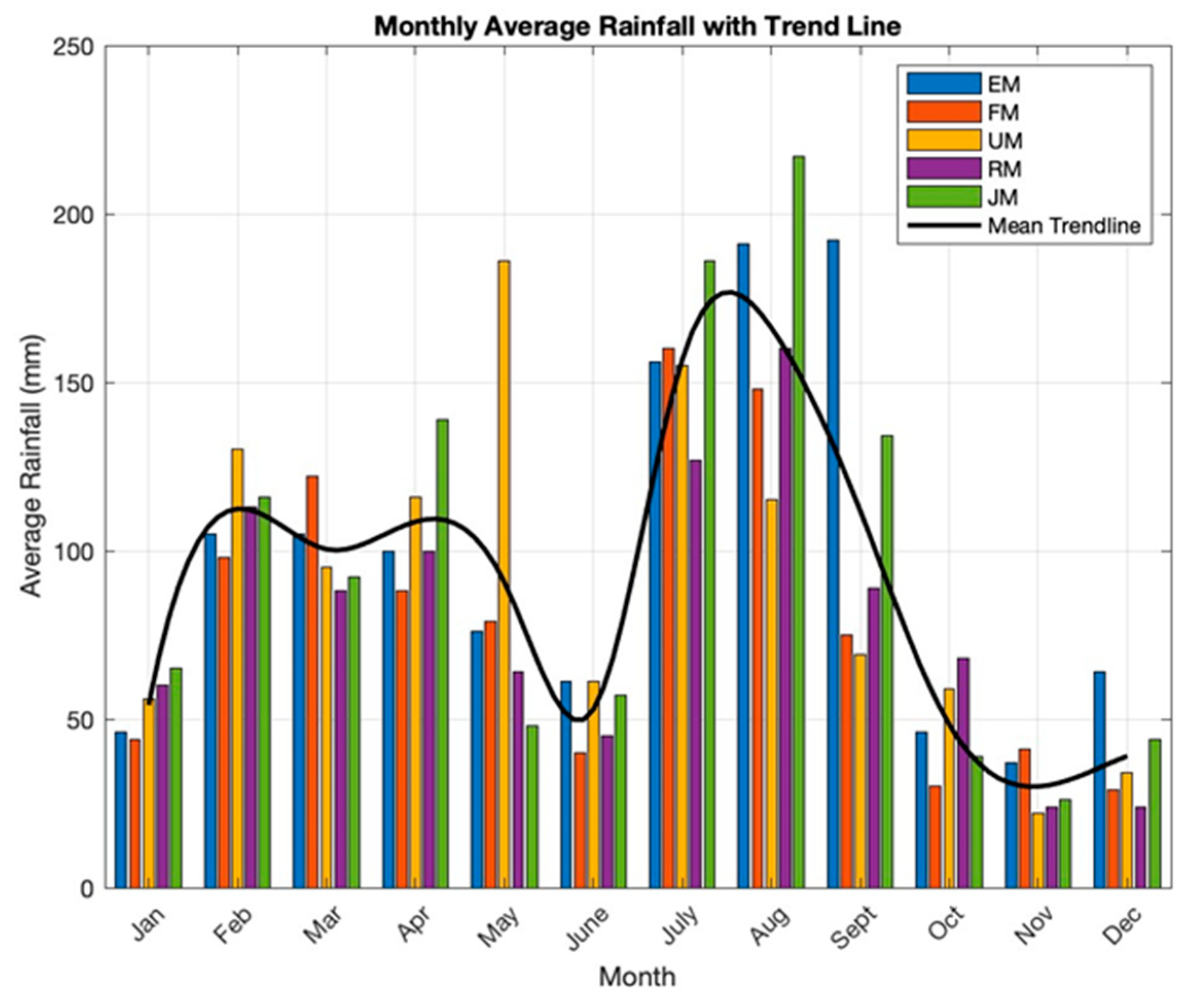
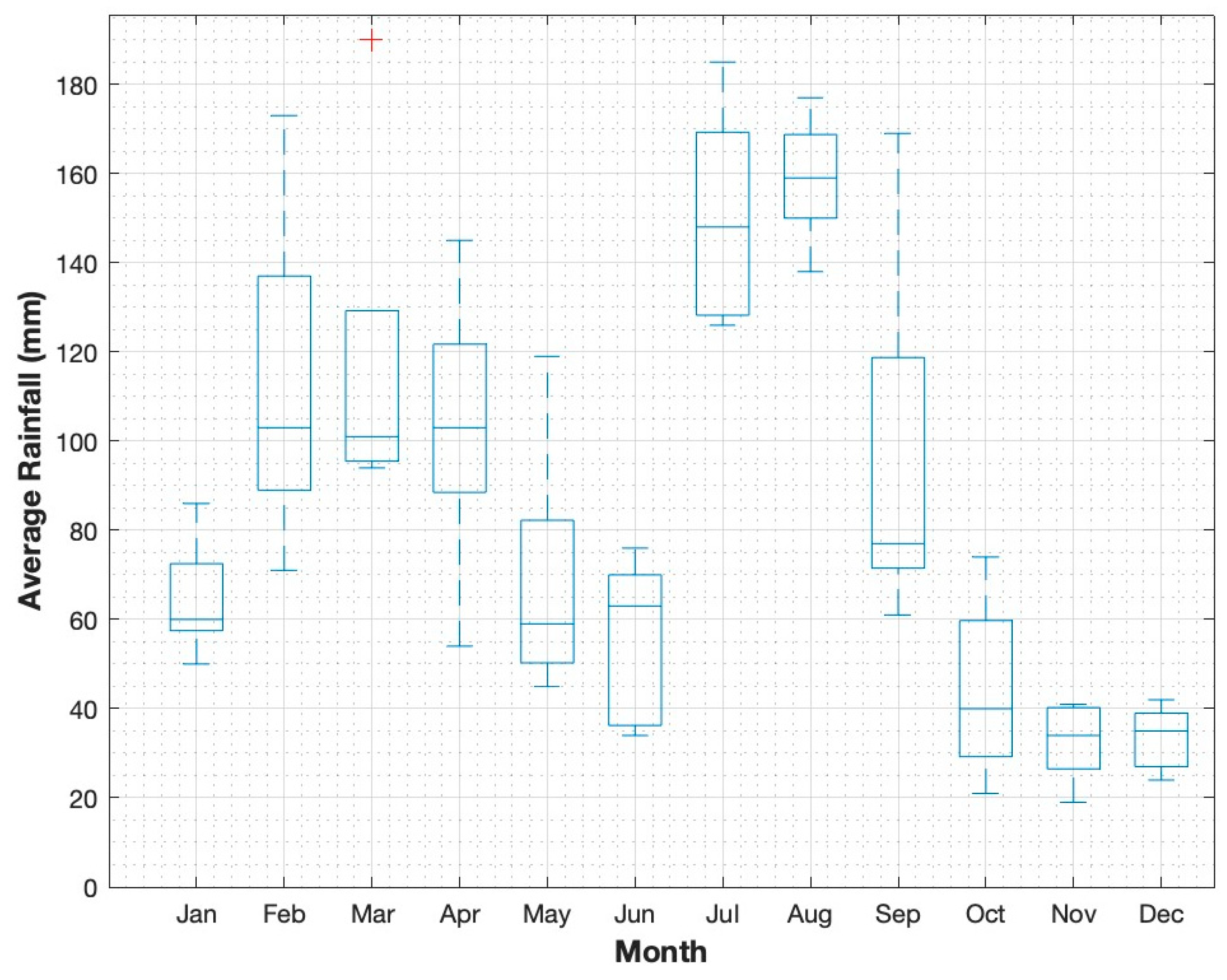
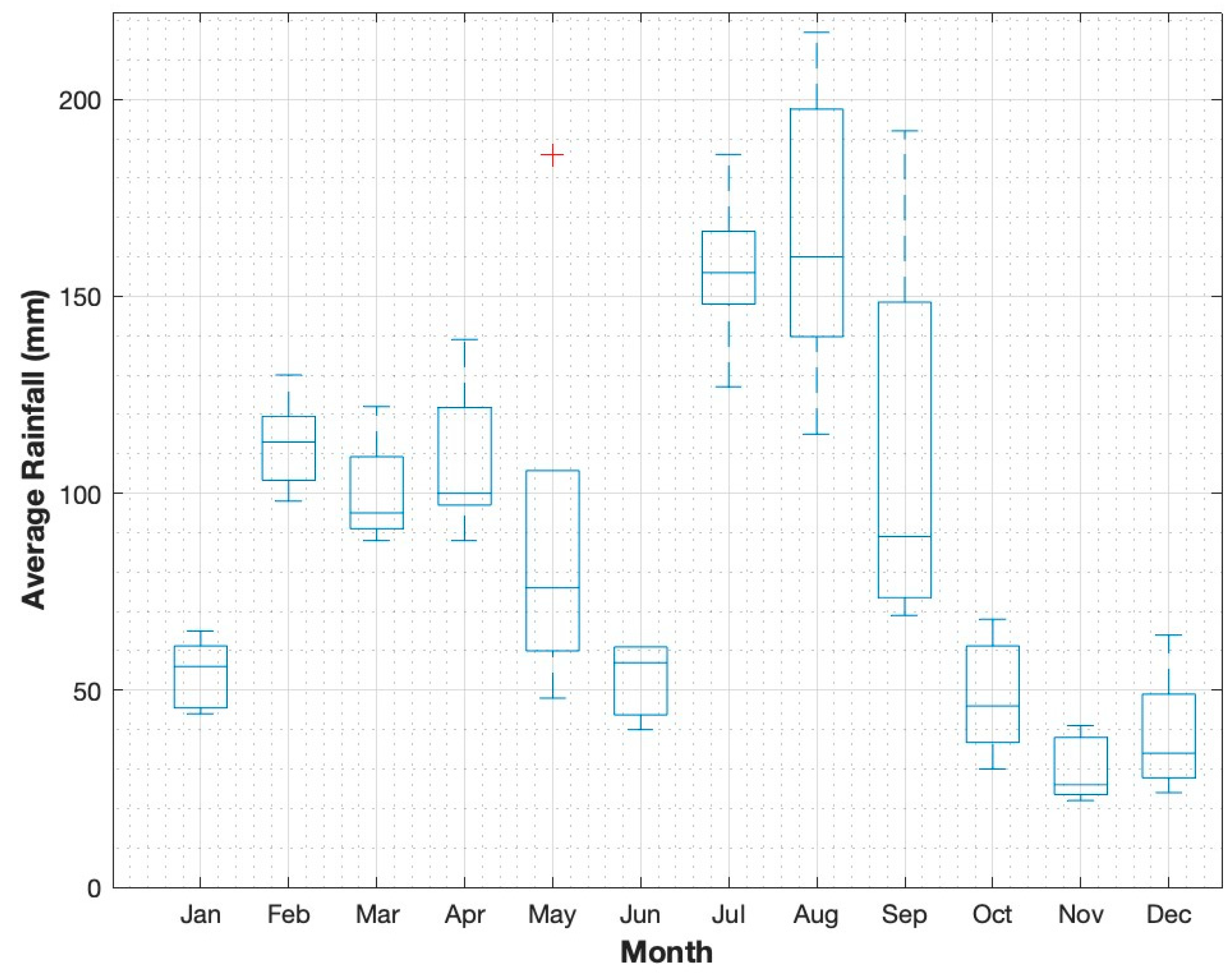
3.1.1. Analysis of the Monthly Average Rainfall

To develop the model for the RWHS for the Swat region, first the monthly average rainfall data are analyzed and then the parameters related to the geographics as well as the demographics of the region are incorporated into that model. In general, the proposed model for the RWHS includes finding the linear relationship between the catchment area A (meter square), coefficient of runoff R, and the measure of the rainfall intensity in (mm/month). The model will provide the estimated volume of the rainwater that could potentially be harvested (denoted as Q) in cubic meters, respectively. Given that the relationship among these three parameters is linear, their interdependence is characterized by the variability of each parameter affecting the others. This means that changes in one parameter will lead to proportional changes in the others, highlighting a direct and predictable connection between them.
The monthly rainfall data recorded for the climate models EM, FM, UM, RM, and JM, respectively, for the SSP2–4.5 scenario are shown in Figure 2. The scenario 2–4.5 is considered as the normal scenario where global earth temperature is in the range from 1 to 2 degrees as reported in [1]. In Figure 2, the x-axis represents the twelve months of the year whereas the y-axis represents the average rainfall calculated in mm for the five models from Europe (EM), France (FM), USA (UM), Russia (RM) and Japan (JM), respectively. The average monthly rainfall is analyzed for the 30 years from 2015 to 2045. Clearly, this analysis covers a span of 30 years, from 2015 to 2045, with the initial years representing actual historical records (2015 till date) followed by the future projections (until 2045). The inclusion of both historical data and predicted rainfall patterns allows for a comprehensive understanding of rainfall trends in the Swat region. From Figure 2, it can be seen that in January, the rainfall is relatively low, with values ranging from 50 mm for EM to 68 mm for JM, indicating the transition from the dry season. February marks a significant increase in the rainfall pattern, particularly for the EM, where a peak at 125 mm is observed, suggesting the onset of wetter conditions. March further amplifies this trend, with FM reaching an impressive rainfall of 190 mm, indicating the localized heavy precipitation events.
April shows substantial rainfall across all models except UM which is around 50 mm, FM and RM recording 145 mm and 103 mm, respectively, before a notable decline in May, where FM drops to 52 mm. June introduces variability, highlighted by FM reduce to 70 mm, which could indicate significant weather anomalies. The rainfall peaks in July, with EM at 164 mm and JM at 185 mm, likely reflecting monsoonal activity.
August maintains high rainfall levels, but September sees EM rise again to 169 mm, while FM experiences a decline in the rainfall patter. October records the lowest values of the year, particularly for FM at 32 mm, indicating a transition to the dry season. November and December exhibit a consistent pattern of reduced rainfall, characteristic of late fall and winter.
It can be observed that overall, the EM, UM and JM climate models predicted a stronger signature of the rainfall during peak months, while the FM exhibits a notable variability in the predicted rainfall pattern, especially in March. UM unique response in June highlights its sensitivity to specific weather phenomena, while RM maintains stability throughout the year.
Figure 3 shows the average rainfall pattern for the five climate models EM, FM, UM, RM, and JM under SSP5–8.5 that has a global warming as high as 4 °C as reported in [1]. This analysis covers a 30-year period from 2015 to 2045, incorporating both historical records and future predictions. In Figure 3, it can be seen that in the month of January, rainfall values are relatively low, ranging from 44 mm for FM to 65 mm for JM. A notable increase in rainfall occurs in February, particularly for UM, which peaks at 130 mm, indicating a transition toward wetter months. March maintains this trend, with EM and FM each recording 105 mm, reflecting consistent precipitation levels during this period.
April presents varied rainfall, with JM reaching a significant 139 mm, while EM and FM see lower totals, suggesting variations in rainfall distribution. May shows an intriguing spike in precipitation for UM, which rises dramatically to 186 mm.
As the summer months approach, July displays the highest rainfall across most models, with JM recording 186 mm and EM at 156 mm, highlighting a shift to more intense precipitation patterns. August continues this trend, with EM and JM reaching peak values of 191 mm and 217 mm, respectively, illustrating the potential for extreme weather events under climate scenario 5–8.5.
In the subsequent months, September rainfall remains elevated at 192 mm for EM, while other models show a decrease. October and November present further reductions in precipitation, with values dropping as low as 22 mm for UM in November, indicating a potential return to drier conditions. December concludes the year with varied totals, suggesting a slight recovery in rainfall as it ranges from 29 mm for FM to 64 mm for EM.
This detailed examination of monthly rainfall data under SSP5–8.5 illustrates significant fluctuations in precipitation, emphasizing the potential impacts of climate change on rainfall patterns.
The analysis of rainfall patterns under SSP 2–4.5 and SSP 5–8.5 provides important insights into the potential impacts of the climate change on precipitation distribution and intensity. These scenarios represent the different levels of greenhouse gas emissions, with SSP 2–4.5 typically associated with moderate emissions and climate change effects, while SSP 5–8.5 is linked to high emissions, leading to more severe climatic alterations as reported in [1].
In SSP 2–4.5, the monthly rainfall data indicate a clear seasonal variation. For instance, January exhibits relatively low rainfall, with values ranging from 50 mm for the EM to 68 mm for JM. This pattern reflects the transitional nature of the region from the dry season, suggesting limited precipitation availability at the beginning of the year. The significant increase in rainfall observed in February, particularly with EM peaking at 125 mm, marks the onset of wet conditions, which is corroborated by the literature indicating that moderate climate scenarios can lead to increased precipitation during transitional months [41].
As the year progresses, March shows an even more pronounced peak with FM reaching 190 mm, indicating localized heavy rainfall events. This trend of increasing rainfall continues through the summer months, peaking in July and August, which may also align with projections that suggest an intensification of extreme weather events due to climate change [42].
Conversely, SSP5–8.5 shows a more alarming picture. The rainfall data reveal an even greater intensity, particularly in months like February, where UM shows a peak at 130 mm, and further spikes in May and July and reaching 186 mm. This scenario illustrates a potential increase in the extreme precipitation events, which are expected to occur more frequently under the higher emissions scenarios. Studies show that as temperatures rise, the atmosphere can hold more moisture, leading to heavier rainfall during storm events [43]. The results from August are particularly striking, with JM reaching a maximum of 217 mm, underscoring the potential for severe weather events that can increase the risk of flooding. The variability observed in September, where rainfall from EM remains high at 192 mm while other models drop significantly, indicates the unpredictability of weather patterns associated with climate change.
The declining rainfall trends in October and November for SSP5–8.5, coupled with minimal rainfall in December, highlight the potential for seasonal droughts following intense rainfall periods. This suggests a shift towards more pronounced variability in precipitation [44].
In order to provide a more specific average rainfall pattern for all the satellites in each month, the boxplot representation is also adopted and is visualized in Figure 4 and Figure 5, respectively. The box plot analysis incorporates the data from all the climate models (EM, FM, UM, RM, and JM) and reveals significant insights into the monthly average rainfall patterns observed between January and December. Each box plot for the respective months effectively illustrates the (minimum, maximum, 25th and 75th quartile) for the rainfall pattern data, respectively.
In Figure 5, it can be seen that in January, the rainfall values are relatively low across all models, with an average rainfall values recording 60 mm. This value is the average rainfall for all models for the month of January. Similarly, the average rainfall pattern for other models in the subsequent months is seen Figure 5. The highest of the noted average rainfall observed is found to be occurring in July and August, respectively.
In Figure 5, the box plot for the SSP5–8.5 scenario presents a comprehensive view of the average monthly rainfall data across five climate models throughout the year. It is clearly illustrated that the peaking average rainfall is occurring in the July and August season. In contrast, the winter months, such as January and December, reveals the lower median rainfall values, which align with the typical seasonal trends. These seasonal variations indeed effect the design of RWHS, particularly in determining the storage capacity requirements. For instance, the peak rainfall months (July–August) provide an opportunity for maximum water collection, while dry months (October–December) necessitate sufficient storage to sustain demand. Under SSP5–8.5, the intensification of extreme rainfall events suggests that RWHS should include overflow mechanisms to manage excess water, whereas prolonged dry spells emphasize the need for larger storage tanks to ensure water availability during drought periods.
It is also important to note that the rainfall analysis in Figure 4 and Figure 5 also tells more about the inter variability of the climate projection models for the two scenarios. A broader range of analysis is needed for more accurate predictions of rainfall patterns and dry seasons, which are essential for the effective RWHS design. In our study, it can be seen that EM and JM presented relatively similar outcomes, particularly during the monsoon peak (July–August), while FM and RM showed close alignment in transitional months like February and April. However, UM exhibited a distinct deviation, especially in May, where it predicted significantly higher rainfall than the other models (this is true for the SSP2–4.5 scenario).
On the other hand, for the SSP5–8.5 scenario, the models EM and JM exhibited similar rainfall patterns, particularly during the monsoon peak (July–August), while FM and RM aligned in transitional months like April and October. However, UM displayed high variability, especially in March and May, where it predicted significantly higher rainfall than the other models.

3.1.2. Roof Water Harvesting System Design Calculation

For calculating the quantity of water that could possibly be harvested through the roofs for an average house size of 120 square meters, the catchment area A, coefficient of the runoff and the average rainfall intensity R is calculated using the formula [45]:
Q n = n = 1 12 R n f i r s t   f l u s h   × A × C   ;
where Q n represents the volume of rainwater that could be harvested in the month n (in cubic meters, m 3 ); A is the catchment area (in square meters, m2); and R n is the rainfall intensity (in meters, m ) per month, respectively. For instance, if the average rainfall pattern observed for the Europe model (EM) in the month of January is calculated to be R 1 = 49.5   mm or R 1 = 0.0495   m ( n = 1 ), the catchment area is calculated to be 120   m 2 , the coefficient of the runoff reads to be 0.80; and the first flush volume of water is advised to be 5   m m or 0.005   m as reported in [2], then the corresponding volume of the rainfall that could be potentially stored is as follows: Q 1 = 0.0495 0.0055   m × 120   m 2 × 0.80 = 4.3   m 3 . Similarly, the rainwater that could be saved for the rest of the months of the year is calculated and tabulated in Table 3 and Table 4, respectively, for the scenario SSP2–4.5 and SSP5–8.5.

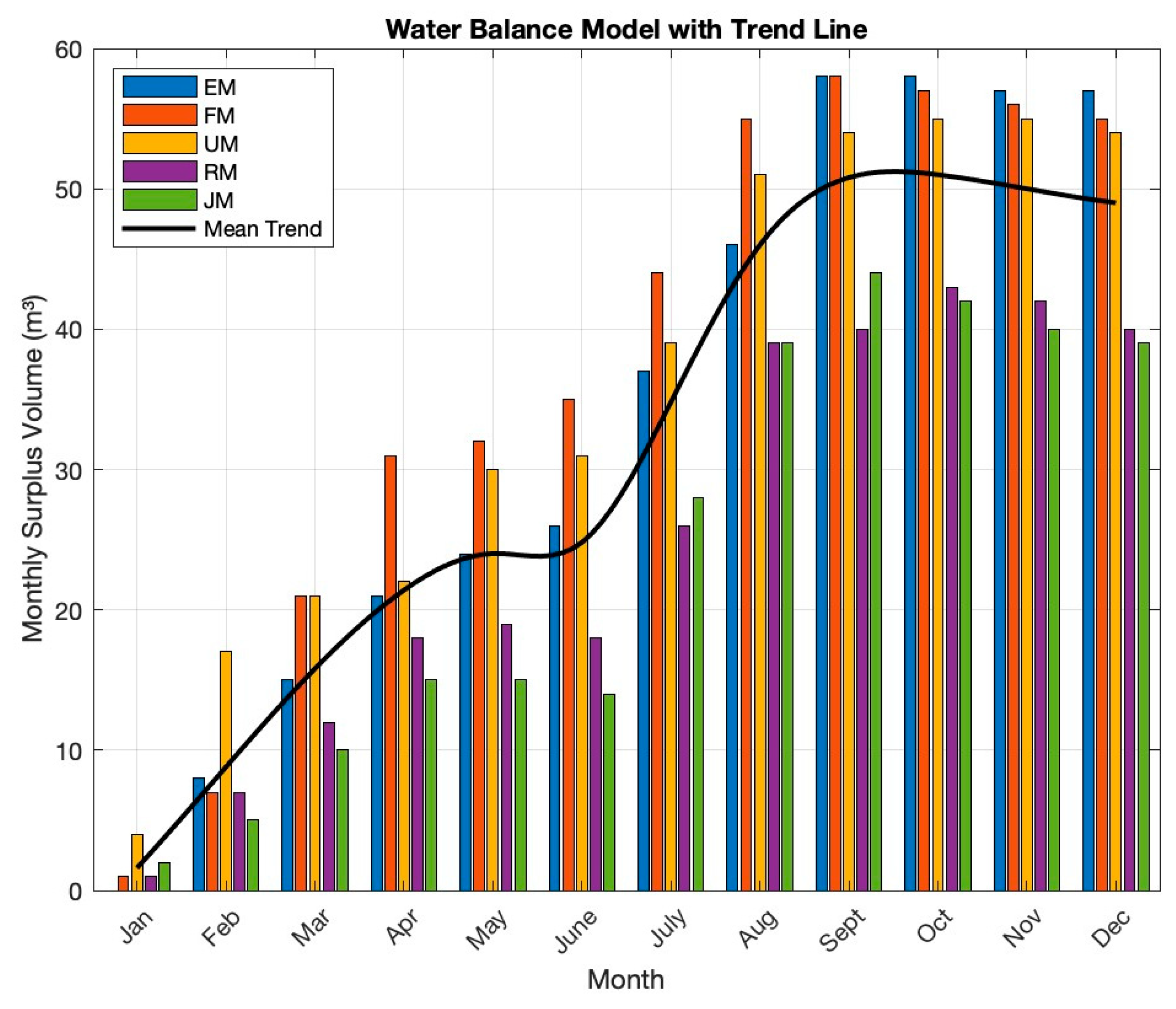
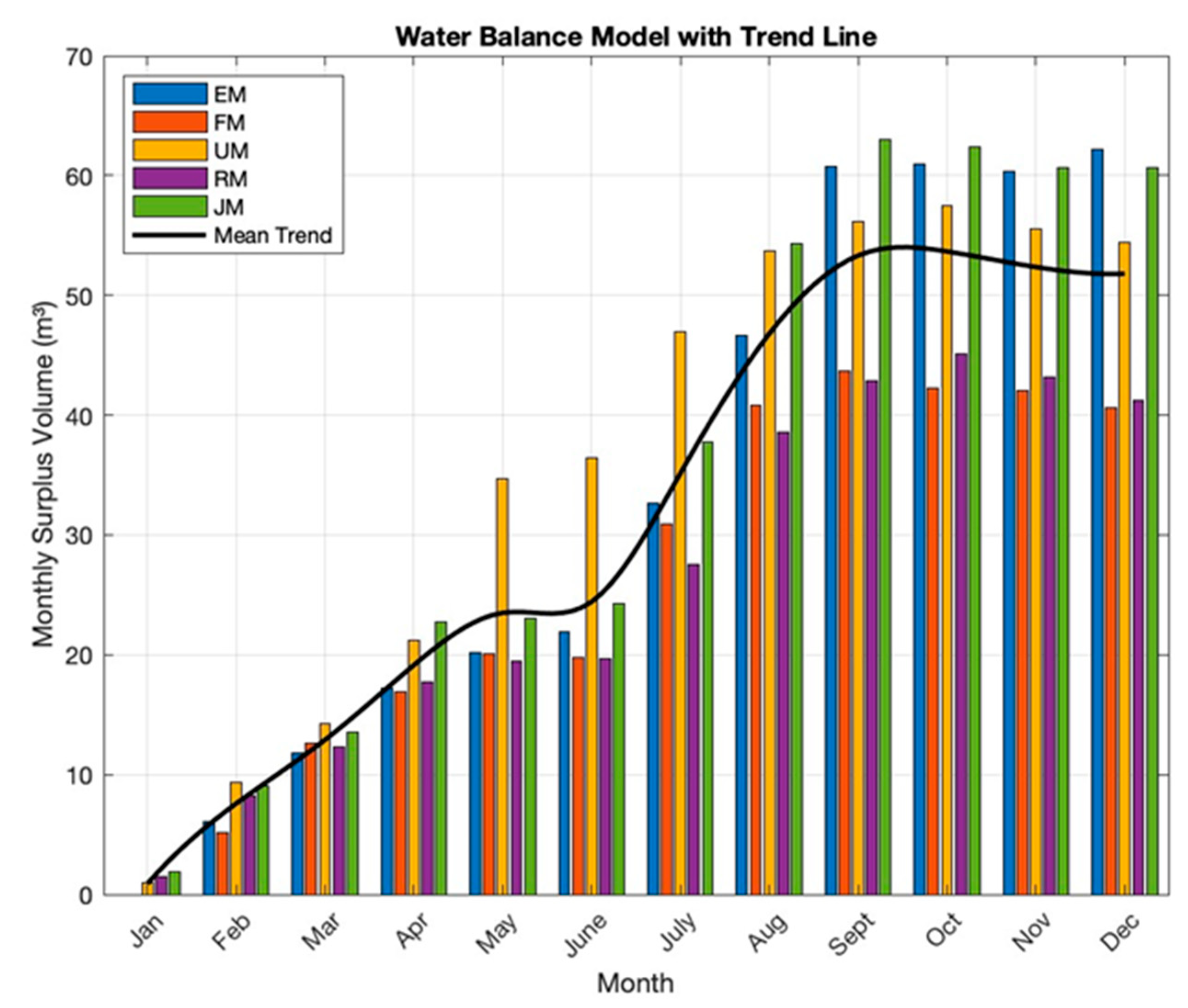
3.2. Water Balance Model

As the RWHS is different from the conventional water supply systems because they are highly dependent on the natural water cycle, their behavior is dynamic too. Meaning that this is fluctuating with the seasons of abundant rainfall followed by periods of droughts. Predicting the future rainfall patterns allows the storage of surplus rainfall, which can later be utilized during droughts periods. One of the objectives of this study is to design the RWHS that meets the water demand of the Swat region during the flood seasons while also providing the additional storage capacity of water tanks for the future use in periods of drought.
In order to calculate the cumulative water stored in the tank, it is required to estimate the harvested rainwater (in cubic meters) on a monthly basis, denoted as V n and then to finally calculate the cumulative water storage of the tank, denoted as S n . To calculate the volume of harvested rainwater for each of the 12 months, we use a formula already established in [46] and expressed as follows:
V n = I n I f × A × R c , I n I f 0 0 , I n I f < 0 ;   f o r n = 1 , 2 , , 12
where V n is the harvested rainwater for the nth month (in cubic meters, m3); A is the catchment area (m2) set at 120 m2; I n represents the total rainfall in month n (in millimeters, mm) and this value is based on the monthly average rainfall data collected in a particular month; I f denotes the first flush rainfall (mm), set to constant value of 5 mm; R c is the runoff coefficient with the value 0.80. It is to be noted that if the condition I t I f < 0 holds true then V n will be equal to zero meaning that no rainwater is harvested on that day. By collecting predicted average rainfall data ( I n ) for a particular month n and fitting the values of the parameters ( A , I f and R c ) into Equation (2), the amount of monthly harvested rainwater can be calculated for both scenarios, i.e., SSP2–4.5 and SSP5–8.5, respectively.
Once, the monthly harvested rainfall water is calculated, then the cumulative water stored in the rainwater tank at the end of the particular month can be calculated using the formula below:
S n = 0 , V n + S n 1 D < 0 C , V n + S n 1 D > C V n + S n 1 D , o t h e r w i s e ;   f o r n = 1 , 2 , , 12
where S n is the cumulative water stored in the rainwater tank at the end of the n-th month (in cubic meters, m3); V n is the volume of harvested rainwater for the n-th month (in cubic meters, m3); and S n 1 is the amount of water stored in the tank from the previous month (in cubic meters, m3). For the first month when n = 1 , S 0 is defined as the initial water storage, typically set to if the tank starts empty. D represents the monthly water demand (in cubic meters, m3); and C represents the capacity of the rainwater storage tank (in cubic meters, m3), respectively. Certain conditions are also required to be met in order to ensure that the water storage stays within realistic limits. For instance, if V n + S n 1 D < 0 , then storage tank capacity will be zero so that the water storage does not go below zero, meaning no negative storage values are allowed. Similarly, if V n + S n 1 D > C then the S n equals to C meaning that the water storage does not exceed the tank’s capacity, capping the stored volume at C . Finally, the standard form of Equation (3) is used for calculations when the storage level remains within these acceptable limits.
By incorporating all the parameter values into Equation (3), the monthly water storage in the tank is calculated and visualized for both the scenarios as shown in Figure 6 and Figure 7, respectively. These results are ranging from a period of results span 30 years. The x-axis represents the months of the year, while the y-axis shows the monthly surplus of water that could possibly be stored in the tank in cubic meters, respectively.
From Figure 7, it can be seen that the ideal months to harvest rainwater are in the Monsoon season during the months of July, August and September. These months are generating the highest cumulative overflow volumes—58 m3 in September—and lasting the following three months. While for the SSP scenario 5–8.5, the amount of surplus water to be stored is noted to be 63 m3, respectively, as shown in Figure 7. The surplus volumes are generated after meeting the monthly minimum water demand of 3.8 m3 for a family of seven people and the surplus volumes can be stored for future use. The water stored from these peak overflows can facilitate household water requirements in subsequent months when needed in emergency situations, such as during the drought periods. The water balance volumes from both scenarios 2–4.5 and 5–8.5 indicates that the RWHS can effectively manage water supply using the excess rainwater stored during monsoon season to meet water needs in subsequent months or the times of droughts.

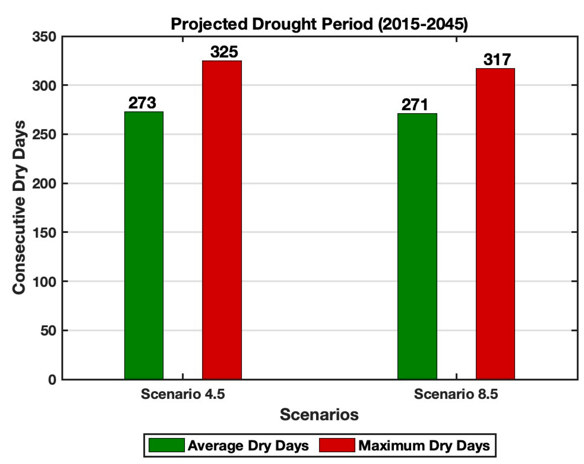
3.3. Projected Drought Periods and Storage Requirements for Roof Water Harvesting Systems

Drought periods refer to the times of the year when there is insufficient rainfall to replenish reservoirs, feed river bodies, or support crop irrigation [47]. Floods and droughts are among the most significant impacts of climate change [48]. By analyzing the SSP-based climate models under scenario 2–4.5 and 5–8.5, instances of both extreme rainfall and prolonged dry spells can be evaluated. While some months are projected to experience intense and higher-than-usual rainfall, there are also periods where rainfall is expected to be less than one millimeter. The RWHS is designed to address emergency water needs in the region during floods and during periods of droughts to ensure the continuous supply of water. One of the key objectives of this study was to calculate the number of consecutive dry days under both climate scenarios, so that the stored surplus water that is calculated using Equation (3), can be utilized effectively. The average drought period over 30 years was determined using climate model projections, with results indicating that average consecutive dry periods may last approximately 9 months, while the maximum could extend up to 11 months without rainfall. These findings are presented in Figure 8, respectively. The metric for dry days was calculated using a precipitation threshold of less than one millimeter for the period from 2015 to 2045 [26].
For instance, the design of storage tanks for RWHS must account for the projected average and maximum drought durations. If the average dry season lasts for 273 days, the required storage volume for a household of seven people, with a per capita daily water demand of 17 L, would be 33 m3. This ensures sufficient water supply during dry periods. For the maximum drought period of 325 days, the storage volume would increase to 39 m3, ensuring resilience during longer-than-usual droughts.

3.4. Performance Evaluation of the Roof Water Harvesting System Under Climate Scenarios

Roof Water Harvesting Systems (RWHS) are increasingly recognized as a viable solution for ensuring water supply during periods of water scarcity, especially in regions that experience both droughts and floods. In this study, the performance of RWHS is evaluated by comparing the system’s rainwater yield against the minimum water demand required for basic activities, such as drinking, which is estimated at 17 L per person per day. This performance evaluation is critical for determining the system’s reliability during the emergency situations, including those caused by the climate-induced disasters such as floods and droughts. The performance of RWHS is measured by calculating the demand satisfaction, which quantifies the system’s capacity to meet the water needs for emergencies. The demand satisfaction can be expressed using the following equation:
Demand % = Rainwater   Yield   m 3 Demand   m 3 × 100 ;
Table 5 shows the demand satisfaction calculation for an emergency water need based on five climate models (Europe, France, USA, Russia, Japan) under both SSP2–4.5 and SSP5–8.5 scenarios. The demand satisfaction is presented as a factor relative to the minimum water demand (17 L per person per day). The tabulated data in Table 5, provide insight into the system’s ability to meet water needs during extreme weather events projected by the climate models. In this table, “2.25×” for the Europe climate model under the SSP2–4.5 indicates that the proposed RWHS model provides 2.25 times the minimum required water demand, equivalent to a 1.25× surplus. Similarly, the other climate models (France, USA, Russia, Japan) show that RWHS model can supply more than the required water demand, ensuring sufficient water availability during emergencies. The results indicate that RWHS can effectively meet water needs during future climate-induced emergencies. Under both SSP2–4.5 and SSP5–8.5 scenarios, the RWHS provides a substantial surplus of water, exceeding the baseline demand for essential activities.
Under SSP2–4.5 scenario, the proposed model for the RWHS for the Europe provides the highest rainwater yield, exceeding the required water needs by up to 225%. In contrast, the model generated for Japan demonstrates the lowest performance among the five climate models but still provides 185% of the required water, ensuring emergency needs are met.
In SSP5–8.5, the RWHS model generated for the Europe, continues to deliver the highest fulfillment, meeting 238% of the water demand. The model for France and Russia both meet around 190% of the water needs, far exceeding the 100% demand fulfillment threshold. This confirms that the RWHS can reliably supply water above the minimum requirement during emergency and drought situations.
For drought periods, RWHS model still shows promising results. Under climate model (Russia) in SSP scenario 2–4.5, the system meets 111% of water demand, which is the lowest among the models. Meanwhile, the model under SSP 5–8.5 provides the highest water supply, fulfilling up to 187% of the demand. The climate model for France meets the least at 113% of demand.
Overall, the RWHS provides a significant surplus of water across all climate models, ensuring that the minimum water needs for emergencies, including drinking, cooking, hygiene, and ablution, can be met.
The study shows that RWHS systems can provide a reliable and sustainable source of water, even under extreme climatic conditions. These findings are valuable for policy makers and engineers seeking to design water supply systems that are resilient to the challenges posed by future climate change scenarios. Also, the area of application for RWHS is quite extensive, especially in those areas which are experiencing climate crisis like floods and drought. As Pakistan is a climate vulnerable country, it provides the most conducive environment for harnessing the climate friendly strategies such as RWHS. However, the implementation of the RWHS in Swat requires policy integration, financial incentives, and public awareness programs to promote its adoption. Additionally, the standardized design guidelines and pilot projects can help to scale up RWHS as a climate adaptation strategy for long-term water security.

4. Conclusions

This study highlights climate-inclusive RWHS as a sustainable response to drinking and basic water provision for emergency in Swat, Pakistan, amidst intensifying climate-driven hydrometeorological events. By analyzing the rainfall patterns from 2015 to 2045 under two different scenarios under SSP based climate models, it is concluded that the proposed RWHS model can provide up to 100% of essential water needs during the emergencies. However, the implementation of the RWHS in Swat region requires the policy integration, financial incentives, and public awareness programs in order to promote its adoption. Additionally, the standardized design guidelines and pilot projects can also help to scale up the RWHS as a climate adaptation strategy for long-term water security.

Author Contributions

Conceptualization, S.W.Q. and R.R.; methodology, S.W.Q.; software, S.W.Q.; validation, S.W.Q. and R.R.; formal analysis, S.W.Q.; investigation, S.W.Q.; resources, F.A.K. and R.R.; data curation, R.R.; writing—original draft preparation, S.W.Q.; writing—review and editing, S.W.Q.; visualization, S.W.Q.; supervision, R.R.; project administration, R.R. All authors have read and agreed to the published version of the manuscript.

Funding

This research received no external funding.

Institutional Review Board Statement

Not applicable.

Informed Consent Statement

Not applicable.

Data Availability Statement

Data are contained within the article.

Conflicts of Interest

The authors declare no conflicts of interest.

References

  1. Lee, H.; Calvin, K.; Dasgupta, D.; Krinner, G.; Mukherji, A.; Thorne, P.; Trisos, C.; Romero, J.; Aldunce, P.; Barrett, K. Climate Change 2023: Synthesis Report. Contribution of Working Groups I, II and III to the Sixth Assessment Report of the Intergovernmental Panel on Climate Change; The Australian National University: Canberra, Australia, 2023. [Google Scholar]
  2. Bolan, S.; Padhye, L.P.; Jasemizad, T.; Govarthanan, M.; Karmegam, N.; Wijesekara, H.; Amarasiri, D.; Hou, D.; Zhou, P.; Biswal, B.K. Impacts of climate change on the fate of contaminants through extreme weather events. Sci. Total Environ. 2023, 909, 168388. [Google Scholar]
  3. World Economic Forum. What Exactly Is Freshwater and Is There Enough of It? 2022. Available online: https://www.weforum.org/stories/2022/10/water-freshwater-scarcity-uplink/ (accessed on 9 September 2024).
  4. Zaidi, U.F. WWF Reports Differences Between 2010 and 2022 Floods. The Diplomatic Insight. 2024. Available online: https://thediplomaticinsight.com/wwf-reports-differences-between-2010-and-2022-floods/ (accessed on 9 September 2024).
  5. Janowiak, J.E.; Xie, P. A Global-Scale Examination of Monsoon-Related Precipitation. J. Clim. 2003, 16, 4121–4133. [Google Scholar] [CrossRef]
  6. Freni, G.; Liuzzo, L. Effectiveness of rainwater harvesting systems for flood reduction in residential urban areas. Water 2019, 11, 1389. [Google Scholar] [CrossRef]
  7. Ortiz, S.; de Barros Barreto, P.; Castier, M. Rainwater harvesting for domestic applications: The case of Asunción, Paraguay. Results Eng. 2022, 16, 100638. [Google Scholar]
  8. Juliana, I.C.; Syahril Badri Kusuma, M.; Cahyono, M.; Kardhana, H.; Martokusumo, W. Rainwater harvesting system implementation for domestic water use: The environment and financial benefits. In ICoSI 2014, Proceedings of the 2nd International Conference on Sustainable Innovation; Springer: Singapore, 2014; pp. 411–421. [Google Scholar]
  9. Ali, S.; Zhang, S.; Chandio, F.A. Impacts of rainfall change on stormwater control and water saving performance of rainwater harvesting systems. J. Environ. Manag. 2021, 280, 111850. [Google Scholar]
  10. Kanno, G.G.; Lagiso, Z.A.; Abate, Z.G.; Areba, A.S.; Gondol, B.N.; Temesgen, H.; Van Wyk, R.; Aregu, M.B. Estimation of rainwater harvesting potential for emergency water demand in the era of COVID-19. The case of Dilla town, Southern, Ethiopia. Environ. Chall. 2021, 3, 100077. [Google Scholar]
  11. Yadav, B.; Patidar, N.; Sharma, A.; Panigrahi, N.; Sharma, R.K.; Loganathan, V.; Krishan, G.; Singh, J.; Kumar, S.; Parker, A. Assessment of traditional rainwater harvesting system in barren lands of a semi-arid region: A case study of Rajasthan (India). J. Hydrol. Reg. Stud. 2022, 42, 101149. [Google Scholar]
  12. Anchan, S.S.; Prasad, H.S. Feasibility of roof top rainwater harvesting potential-A case study of South Indian University. Clean. Eng. Technol. 2021, 4, 100206. [Google Scholar]
  13. Mane, S.P.; Shinde, A.S. A Study Changing Pattern of Rain Water Harvesting Management an Ancient to Modern Age in India-Geographical Analysis. Rev. Res. 2014, 3, 1–6. Available online: https://www.researchgate.net/publication/328225425_A_Study_of_Changing_Pattern_of_Rainwater_Harvesting_Management_an_Ancient_to_Modern_Age_in_India_A_Geographical_Analysis (accessed on 10 September 2024).
  14. History of Rainwater Harvesting. Available online: https://www.renewableenergyhub.co.uk/main/rainwater-harvesting-information/history-of-rainwater-harvesting/ (accessed on 10 September 2024).
  15. Ahmad, S.; Jia, H.; Ashraf, A.; Yin, D.; Chen, Z.; Xu, C.; Wang, C.; Jia, Q.; Zhang, X.; Israr, M. Water resources and their management in Pakistan: A critical analysis on challenges and implications. Water-Energy Nexus 2023, 6, 137–150. [Google Scholar]
  16. World Bank Group. Pakistan Country Climate and Development Report; World Bank: Washington, DC, USA, 2022. [Google Scholar]
  17. Otto, F.E.; Zachariah, M.; Saeed, F.; Siddiqi, A.; Kamil, S.; Mushtaq, H.; Arulalan, T.; AchutaRao, K.; Chaithra, S.T.; Barnes, C.; et al. Climate change likely increased extreme monsoon rainfall, flooding highly vulnerable communities in Pakistan. Environ. Res. Clim. 2023, 2, 025001. [Google Scholar]
  18. Loo, Y.Y.; Billa, L.; Singh, A. Effect of climate change on seasonal monsoon in Asia and its impact on the variability of monsoon rainfall in Southeast Asia. Geosci. Front. 2015, 6, 817–823. [Google Scholar]
  19. Nanditha, J.S.; Kushwaha, A.P.; Singh, R.; Malik, I.; Solanki, H.; Chuphal, D.S.; Dangar, S.; Mahto, S.S.; Vegad, U.; Mishra, V. The Pakistan flood of August 2022: Causes and implications. Earth’s Future 2022, 11, e2022EF003230. [Google Scholar]
  20. Pakistan_Country_Report_2023. Available online: https://unhabitat.org/sites/default/files/2023/06/4._pakistan_country_report_2023_b5_final_compressed.pdf (accessed on 7 October 2024).
  21. Keely, C.; Reed, H.; Waldman, R. Understanding mortality patterns in complex humanitarian emergencies. In Forced Migration and Mortality; National Academies Press: Washington, DC, USA, 2001. [Google Scholar]
  22. The Associated Press. After Devastating Floods in Pakistan, Some Have Recovered but Many Are Struggling. Available online: https://apnews.com/article/pakistan-flood-anniversary-ebd91932d0452d47c3b0c4bd2a656f38 (accessed on 7 April 2024).
  23. UNICEF Pakistan. WASH: Water, Sanitation and Hygiene. Available online: https://www.unicef.org/pakistan/wash-water-sanitation-and-hygiene-0 (accessed on 14 October 2024).
  24. Moazzam, M.F.U.; Rahman, G.; Munawar, S.; Tariq, A.; Safdar, Q.; Lee, B.-G. Trends of rainfall variability and drought monitoring using standardized precipitation index in a scarcely gauged basin of northern Pakistan. Water 2022, 14, 1132. [Google Scholar] [CrossRef]
  25. Adnan, M.; Khan, F.; Rehman, N.; Ali, S.; Hassan, S.S.; Dogar, M.M.; Mehmood, S.; Hasson, S. Variability and predictability of summer monsoon rainfall over Pakistan. Asia-Pac. J. Atmos. Sci. 2021, 57, 89–97. [Google Scholar]
  26. Avalon Cullen, C.; Al Suhili, R. Assessing rainfall variability in Jamaica using CHIRPS: Techniques and measures for persistence, long and short-term trends. Geographies 2023, 3, 375–397. [Google Scholar] [CrossRef]
  27. UN-Water. Water and Disasters. Available online: https://www.unwater.org/water-facts/water-and-disasters (accessed on 10 July 2024).
  28. Gwoździej-Mazur, J.; Jadwiszczak, P.; Kaźmierczak, B.; Kózka, K.; Struk-Sokołowska, J.; Wartalska, K.; Wdowikowski, M. The impact of climate change on rainwater harvesting in households in Poland. Appl. Water Sci. 2022, 12, 15. [Google Scholar]
  29. Yaziz, M.I.; Gunting, H.; Sapari, N.; Ghazali, A. Variations in rainwater quality from roof catchments. Water Res. 1989, 23, 761–765. [Google Scholar]
  30. Abdulla, F.A.; Al-Shareef, A.W. Roof rainwater harvesting systems for household water supply in Jordan. Desalination 2009, 243, 195–207. [Google Scholar]
  31. Pakistan Bureau of Statistics. Available online: https://www.pbs.gov.pk (accessed on 9 July 2024).
  32. UN Habitat. Blue Drop Series on Rainwater Harvesting and Utilisation—Book 3: Project Managers and Implemetation Agency; UN Habitat: Nairobi, Kenya, 2005. [Google Scholar]
  33. Zaied, R.A. Water use and time analysis in ablution from taps. Appl. Water Sci. 2017, 7, 2329–2336. [Google Scholar]
  34. Center for Humanitarian Health. Sphere Handbook. 2018. Available online: https://spherestandards.org/handbook-2018/ (accessed on 9 July 2024).
  35. Home-Water-Use-ig5. Available online: https://water.phila.gov/wp-content/uploads/files/home-water-use-ig5.pdf (accessed on 27 July 2024).
  36. Ali, Z.; Hamed, M.M.; Muhammad, M.K.I.; Iqbal, Z.; Shahid, S. Performance evaluation of CMIP6 GCMs for the projections of precipitation extremes in Pakistan. Clim. Dyn. 2023, 61, 4717–4732. [Google Scholar]
  37. Karim, R.; Tan, G.; Ayugi, B.; Babaousmail, H.; Liu, F. Evaluation of historical CMIP6 model simulations of seasonal mean temperature over Pakistan during 1970–2014. Atmosphere 2020, 11, 1005. [Google Scholar] [CrossRef]
  38. Mendez, M.; Maathuis, B.; Hein-Griggs, D.; Alvarado-Gamboa, L.-F. Performance evaluation of bias correction methods for climate change monthly precipitation projections over Costa Rica. Water 2020, 12, 482. [Google Scholar] [CrossRef]
  39. Teutschbein, C.; Seibert, J. Bias correction of regional climate model simulations for hydrological climate-change impact studies: Review and evaluation of different methods. J. Hydrol. 2012, 456, 12–29. [Google Scholar]
  40. Tang, B.; Hu, W.; Duan, A. Assessment of extreme precipitation indices over Indochina and South China in CMIP6 models. J. Clim. 2021, 34, 7507–7524. [Google Scholar]
  41. Masson-Delmotte, V.; Zhai, P.; Pirani, S.; Connors, C.; Péan, S.; Berger, N.; Caud, Y.; Chen, L.; Goldfarb, M.; Scheel Monteiro, P.M. IPCC, 2021: Summary for Policymakers. In Climate Change 2021: The Physical Science Basis. Contribution of Working Group I to the Sixth Assessment Report of the Intergovernmental Panel on Climate Change; Cambridge University Press: Cambridge, UK, 2021. [Google Scholar]
  42. Graham, N.E.; Ammann, C.M.; Fleitmann, D.; Cobb, K.M.; Luterbacher, J.; Noone, D.; Pfister, C.; Smerdon, J.E.; von Gunten, L.; Wood, K.; et al. A comparative analysis of the impacts of different greenhouse gas emissions pathways. J. Clim. 2016, 29, 7527–7545. [Google Scholar]
  43. Allan, R.P.; Soden, B.J. Atmospheric warming and the amplification of precipitation extremes. Science 2008, 321, 1481–1484. [Google Scholar]
  44. Versini, P.-A.; Pouget, L.; McEnnis, S.; Custodio, E.; Escaler, I. Climate change impact on water resources availability: Case study of the Llobregat River basin (Spain). Hydrol. Sci. J. 2016, 61, 2496–2508. [Google Scholar]
  45. Ali, S.; Sang, Y.-F. Implementing rainwater harvesting systems as a novel approach for saving water and energy in flat urban areas. Sustain. Cities Soc. 2023, 89, 104304. [Google Scholar]
  46. Khan, A.; Park, Y.; Park, J.; Kim, R. Assessment of Rainwater Harvesting Facilities Tank Size Based on a Daily Water Balance Model: The Case of Korea. Sustainability 2022, 14, 15556. [Google Scholar] [CrossRef]
  47. Riefler, R.F. Drought: An economic perspective. In North American Droughts; Routledge: London, UK, 2019; pp. 63–77. [Google Scholar]
  48. Brunner, M.I.; Slater, L.; Tallaksen, L.M.; Clark, M. Challenges in modeling and predicting floods and droughts: A review. Wiley Interdiscip. Rev. Water 2021, 8, e1520. [Google Scholar]
Figure 1. Map of Swat district of Khyber Pakhtunkhwa province in Pakistan (map created using QGIS 3.4).
Standards 05 00011 g001
Figure 2. Climate models rainfall projections in mm from 2015 to 2045 for the SSP scenario 2–4.5.
Standards 05 00011 g002
Figure 3. Climate models rainfall projections in mm from 2015 to 2045 for the SSP 5–8.5.
Standards 05 00011 g003
Figure 4. Box plot illustrating the average monthly rainfall (in mm) across the five climate models for the SSP2–4.5.
Standards 05 00011 g004
Figure 5. Box plot illustrating the average monthly rainfall (in mm) across the five climate models for the SSP5–8.5.
Standards 05 00011 g005
Figure 6. Monthly Surplus Volume of Harvested Rainwater under SSP2–4.5.
Standards 05 00011 g006
Figure 7. Monthly Surplus Volume of Harvested Rainwater under SSP5–8.5.
Standards 05 00011 g007
Figure 8. Projected periods of droughts for SSP2–4.5 and SSP5–8.5.
Standards 05 00011 g008
Table 1. Population, Average Household Size, and Growth Rate of Swat District.
DistrictPopulation (As per 2023 Census)Average Household Size (Persons/House)Growth Rate (%)
Swat2,687,3847.052.57
Table 2. Simplified Nomenclature for the Climate Models Used in the Climate Projections for RWHS in the Swat Region.
S. NoClimate ModelClimate Model Nomenclature
1CMCC-ESM2 (Europe)Europe Earth System Model (EM)
2CNRM-CM6-1 (France)France Climate Model (FM)
3GFDL-ESM4 (USA)USA -Earth System Model (UM)
4INM-CM5-0 (Russia)Russia Climate Model (RM)
5MIROC6 (Japan)Japan Climate Model (JM)
Table 3. Monthly harvestable rainwater volumes from different climate models for the SSP2–4.5.
Volume of Rainwater Harvested, (m3)
Month (Qn) EMFMUMRMJM
Jan4.35.35.85.36.1
Feb11.59.49.48.66.3
Mar10.017.76.19.28.5
Apr10.513.57.29.49.2
May6.24.54.75.23.9
June6.06.815.82.83.1
July15.213.716.711.617.3
Aug12.714.316.116.514.8
Sept15.76.87.45.49.3
Oct3.42.64.66.71.5
Nov2.83.43.02.31.3
Dec3.62.22.81.92.9
Average8.508.358.297.087.01
Table 4. Monthly harvestable rainwater volumes from the different climate models for the SSP5–8.5.
Volume of Rainwater Harvested, (m3)
Month (Qn)EMFMUMRMJM
Jan3.93.74.95.35.7
Feb9.68.912.010.410.7
Mar9.611.28.77.98.4
Apr9.18.010.79.112.9
May6.87.117.35.74.2
June5.43.45.43.95.0
July14.514.914.411.717.3
Aug17.913.710.614.920.3
Sept18.06.76.18.112.4
Oct4.02.45.26.03.2
Nov3.03.51.71.82.0
Dec5.72.32.81.83.7
Average8.967.158.317.218.82
Table 5. Demand Satisfaction for Emergency Water Needs (Factor relative to the minimum water demand of 17 L per person per day).
Climate ModelsEuropeFranceUSARussiaJapan
Scenario 2–4.52.25×2.21×2.17×1.88×1.85×
Scenario 5-8.52.38×1.90×2.20×1.90×2.33×
Disclaimer/Publisher’s Note: The statements, opinions and data contained in all publications are solely those of the individual author(s) and contributor(s) and not of MDPI and/or the editor(s). MDPI and/or the editor(s) disclaim responsibility for any injury to people or property resulting from any ideas, methods, instructions or products referred to in the content.

