
The Application of Geospatial Analysis Methods for the Reconstruction of Lithuanian–Slavic Ethnolinguistic Boundaries in Southeastern Lithuania

Abstract
1. Introduction
2. Materials and Methods
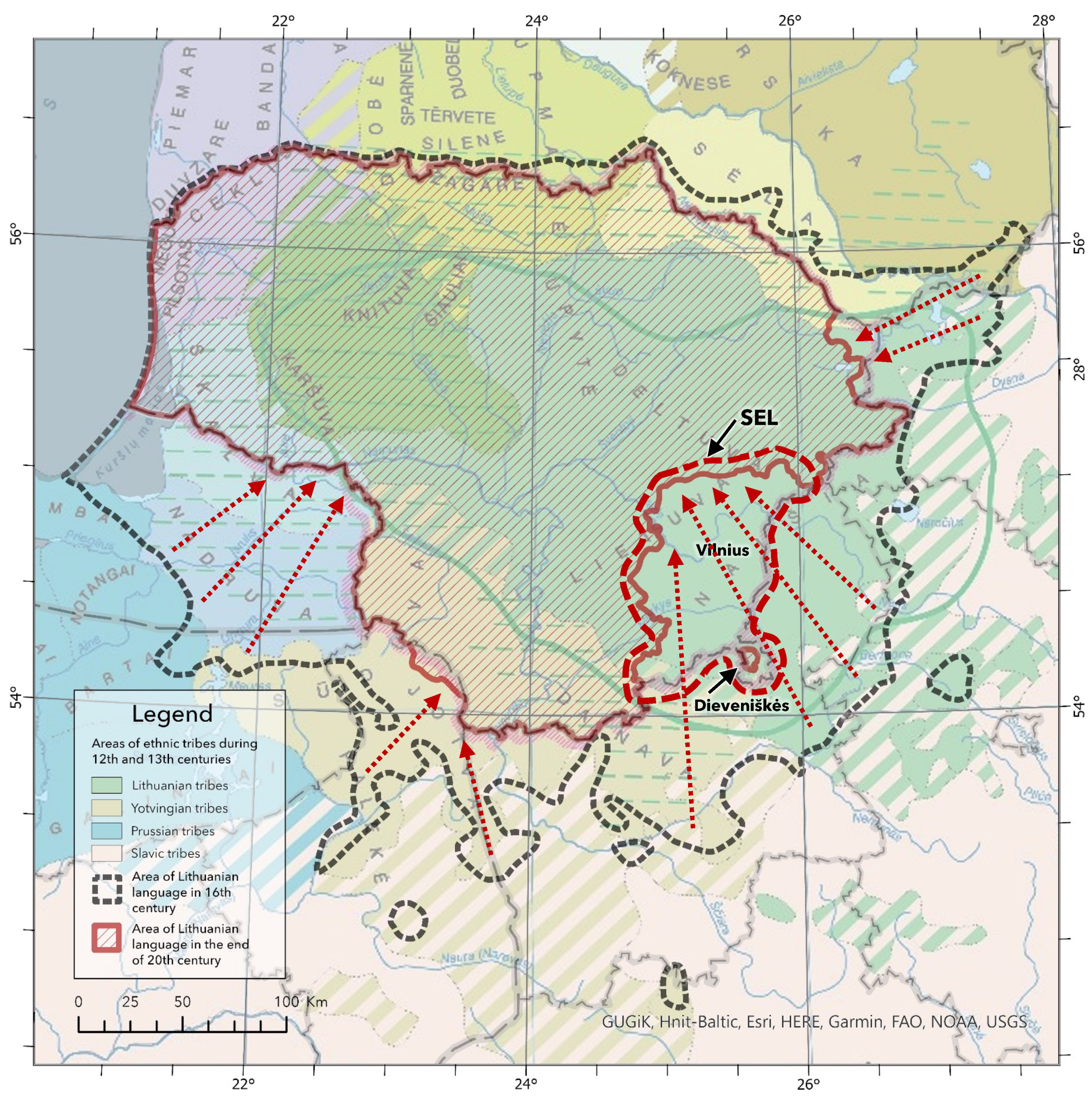
2.1. Study Area
2.2. Study Material and Context
2.3. Research Methods
3. Results
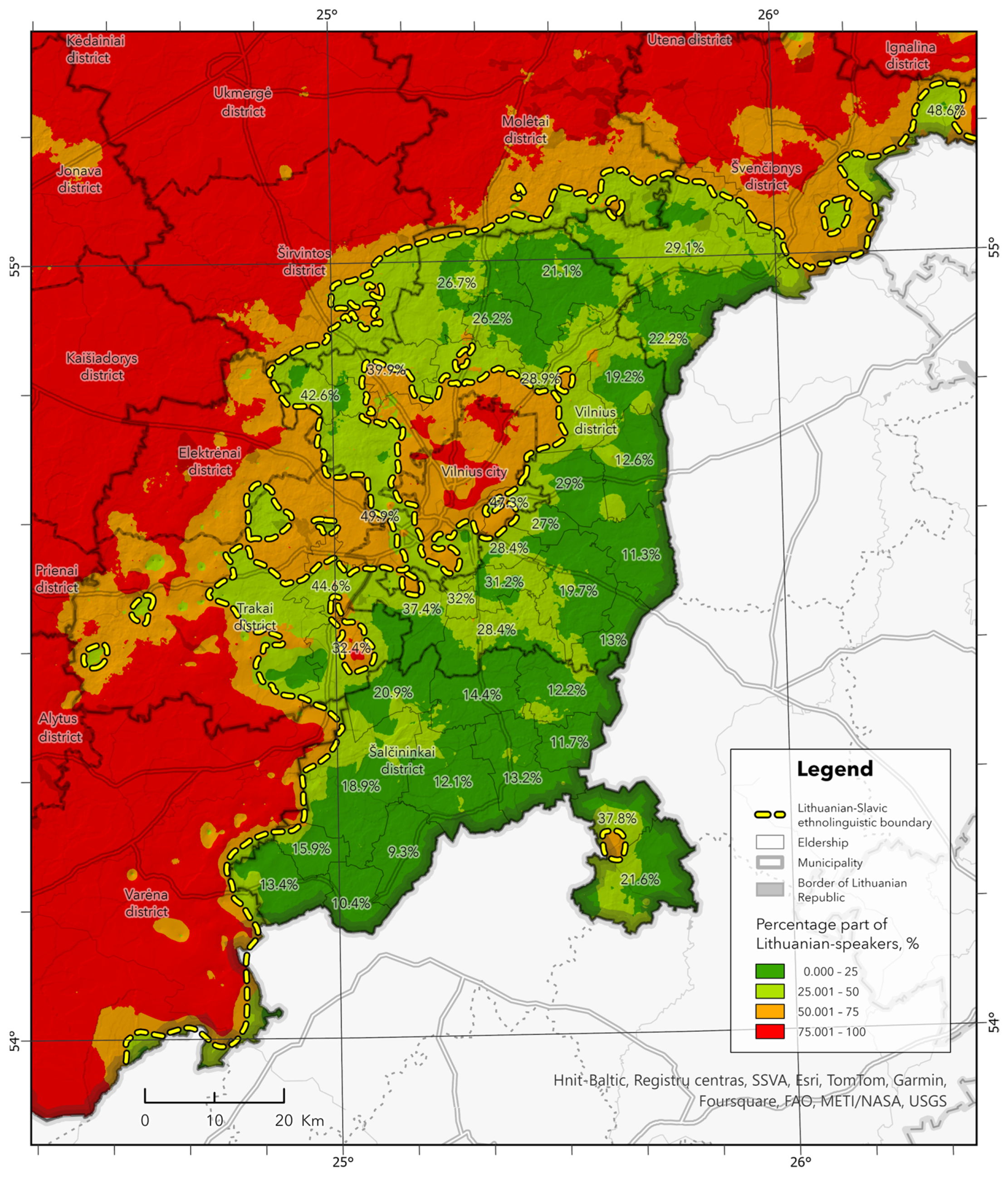
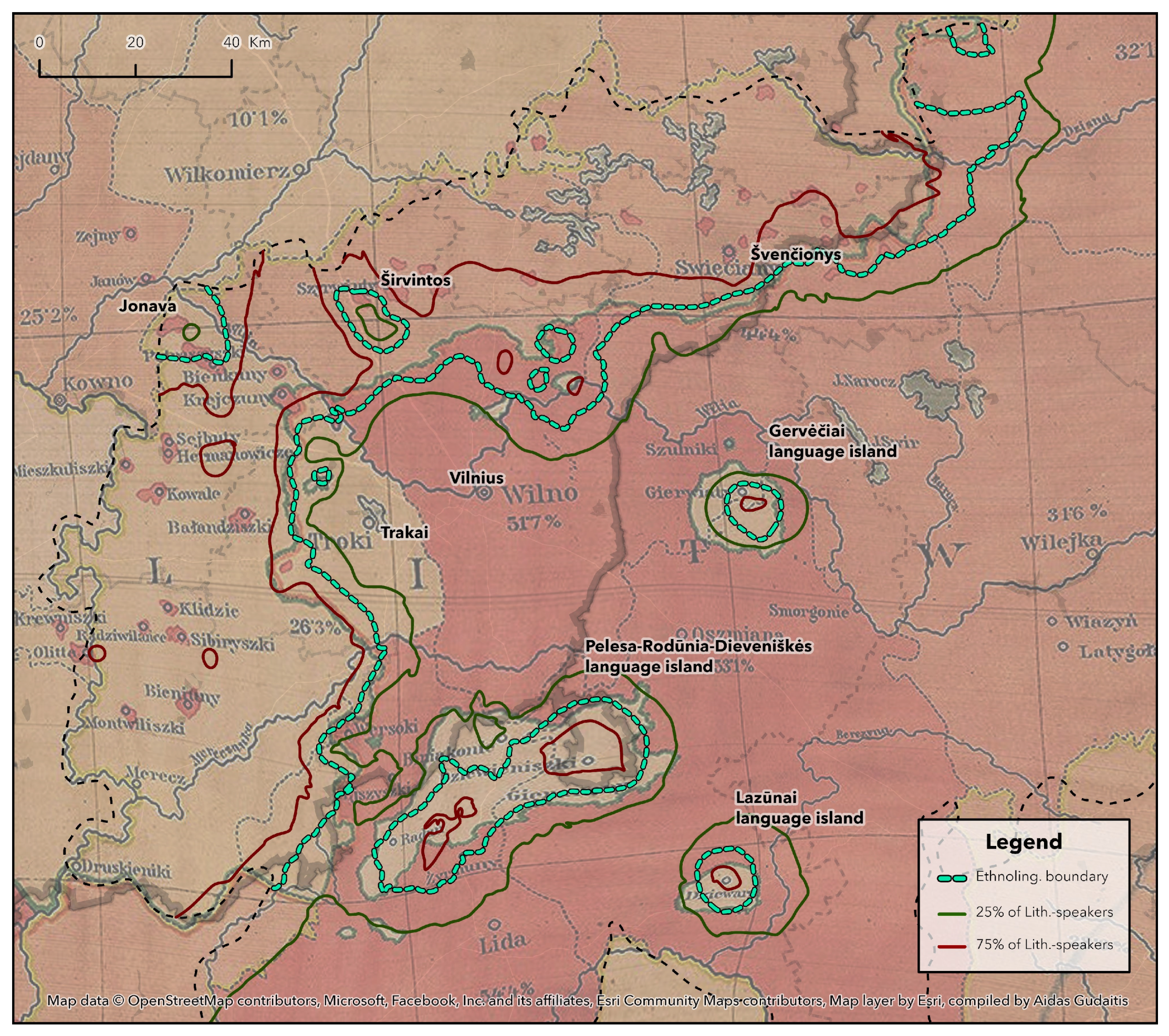
3.1. The Boundary Reconstruction and Ethnolinguistic Situation Analysis
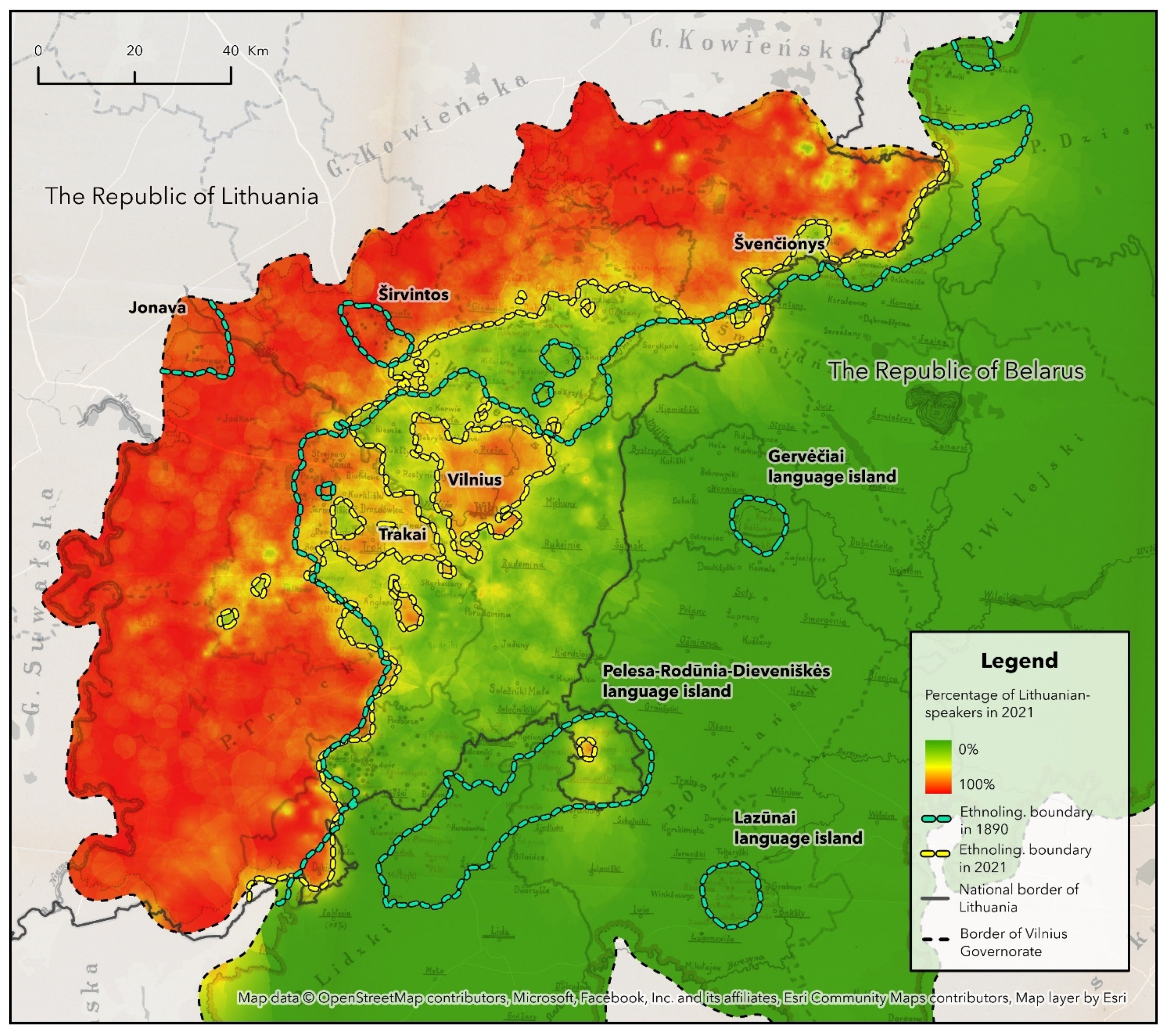
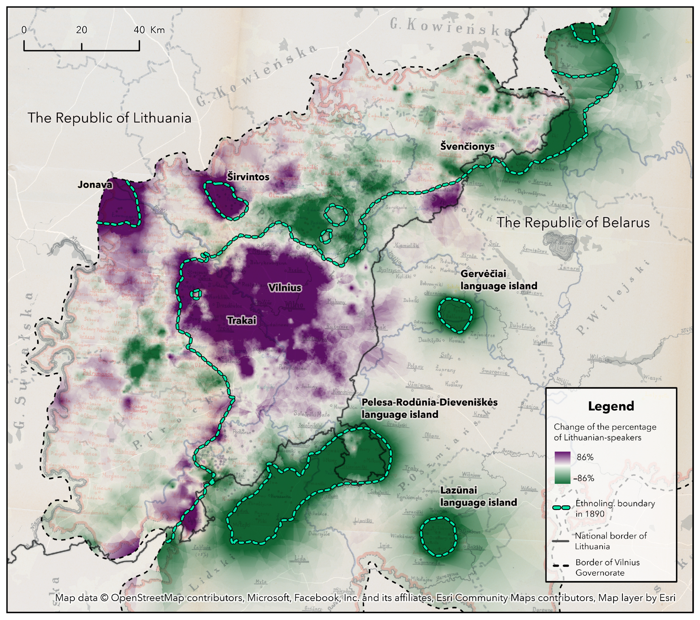
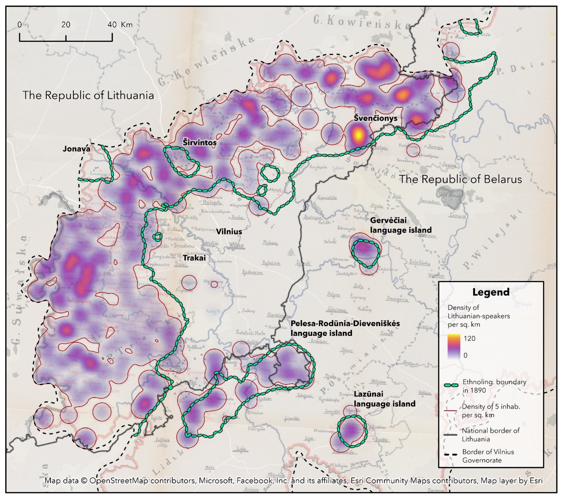
3.2. The Comparative Geospatial Analysis of the Ethnolinguistic Data of Late 19th and Early 21st Centuries
4. Discussion
5. Conclusions
Funding
Institutional Review Board Statement
Informed Consent Statement
Data Availability Statement
Acknowledgments
Conflicts of Interest
| 1 | Geoinformation system (GIS). It is an information technology platform used to describe and characterize the Earth and other surfaces to visualise and analyse geographically (spatially) coordinated information. GIS provides the tools to collect, store, and analyse spatial and geographic data and their attributes. Further: https://www.earthdata.nasa.gov/learn/backgrounders/gis (accessed on 6 November 2024). GIS technology was first used in 1963. Roger Tomlinson, in Canada, developed a vector-based GIS framework and a geodatabase, which at that time made it possible to store and analyse large amounts of spatial land use data. The technical solution enabled the Canadian government to efficiently implement a national land management programme (Waters 2017). |
| 2 | Location intelligence (LI) is the insight gained from visualizing and analyzing geospatial data. More about LI: https://www.esri.com/en-us/location-intelligence/overview (accessed on 6 November 2024). |
| 3 | Eldership (Lith. seniūnijà) is the smallest structural territorial subdivision of a municipal administration in Lithuania, a branch of a municipality’s executive authority having the rights of a legal person, which operates in a given part of the municipality’s territory. Further: https://www.vle.lt/straipsnis/seniunija-2/ (accessed on 6 November 2024). |
| 4 | Further: https://lad.lt/broelalfred/ (accessed on 6 November 2024). |
| 5 | Further: https://www.esri.com/en-us/arcgis/products/arcgis-pro/overview (accessed on 6 November 2024). |
| 6 | LKS-94 is a national realization of ETRS89 and is coincident to WGS 84 within 1 metre. This transformation has an accuracy equal to the coincidence figure. Further: https://epsg.io/3346 (accessed on 6 November 2024). |
| 7 | Interpolation—a method of geospatial forecasting in which the intermediate value of a variable is approximated from known values. In geospatial analysis, various statistical interpolation methods (e.g., Inverse Distance Weighting (IDW), Spline, Kriging, etc.) are used, depending on the specifics of the research (See also: Ripley 2005, chap. 4). |
| 8 | Further: https://pro.arcgis.com/en/pro-app/latest/help/analysis/geostatistical-analyst/what-is-empirical-bayesian-kriging-.htm (accessed on 6 November 2024). |
| 9 | More about Vilna Governorate: https://www.vle.lt/straipsnis/vilniaus-gubernija/ (accessed on 6 November 2024). |
| 10 | Further: https://pro.arcgis.com/en/pro-app/latest/tool-reference/spatial-analyst/contour.htm (accessed on 6 November 2024). |
| 11 | Further: https://pro.arcgis.com/en/pro-app/latest/help/analysis/image-analyst/change-detection-in-arcgis-pro.htm (accessed on 6 November 2024). https://pro.arcgis.com/en/pro-app/latest/help/analysis/image-analyst/pixel-value-change-detection.htm (accessed on 6 November 2024). |
| 12 | The map does not consider the ratio of languages in cities. |
| 13 | Description: https://osp.stat.gov.lt/gyventoju-ir-bustu-surasymai1 (accessed on 6 November 2024). Open data: https://open-data-ls-osp-sdg.hub.arcgis.com/datasets/80272a0f7a7e4905bc379f0ae921e5b7_1/about (accessed on 6 November 2024). |
| 14 | Further: https://pro.arcgis.com/en/pro-app/latest/tool-reference/spatial-analyst/how-kernel-density-works.htm (accessed on 6 November 2024). |
References
- Alminas-Alminauskis, K., and G. Šlepelytė-Sirutienė. 1942. Map. Die Sprachen im Wilnagebiet [Languages in the Vilnius Region]. Vilnius: The Institute of the Lithuanian Language. [Google Scholar]
- Anonim. 1898. Opszar Języka Litewskiego w Gubernii Wilenskiej [Lithuanian Language Area in Vilnius Governorate]. Krakow: Nakładem Akademii Umiejętności. Available online: https://archive.org/details/podernia-obszar-jezyka-litewskiego...-1898/page/8/mode/2up (accessed on 6 November 2024).
- Ayad, Yasser, and Herb Luthin. 2009. Mapping Dialect: GIS Applications in Studying Dialect of Western Pennsylvania. Paper presented at the 2009 ESRI International User Conference Proceedings, San Diego, CA, USA, July 13–17; pp. 1–26. Available online: http://proceedings.esri.com/library/userconf/proc09/uc/papers/pap_1686.pdf (accessed on 6 November 2024).
- Chominski, Olgierd. 2010. Obszar Językowy Litewski w Panstwie Polskim 1927–1933 [The Lithuanian Language Area in the Polish State 1927–1933]. Edited by L. Bednarczuk. Warszawa: Acta Baltico-Slavica, 34 SOW. pp. 197–261. [Google Scholar]
- Chominski, Olgierd, ed. 1933. Mapa Obszaru Językowego Litewskiego w Rzeczypospolitej Polskiej 1928–1933 [Map of the Lithuanian Linguistic Area in the Republic of Poland 1928–1933]. Warszawa: Zakł. Graf. Straszewiczów. [Google Scholar]
- Čekmonas, Valerijus. 2017. Nad Etniczną i Językową Mapą Polaków Litewskich—O Teraźniejszości i Przyszłości [On the Present and Past Considering the Ethnic and Linguistic Map of Lithuania’s Poles]. Vilnius: The Institute of the Lithuanian Language, pp. 115–26, 867–69, 968–70. [Google Scholar]
- Čekmonas, Valerijus, and Laima Grumadienė. 1993. Kalbų Paplitimas Rytų Lietuvoje [Language Distribution in Eastern Lithuania]. Edited by Lietuvos Rytai, Kazimieras Garšva and Laima Grumadienė. Vilnius: State Publishing Centre, pp. 132–36. [Google Scholar]
- Čepaitienė, Agnė, and Aidas Gudaitis. 2021. Rytų Aukštaičių Panevėžiškių Diferencinio Požymio Kaita: Geoerdvinis Aspektas [Change of Phonetic Differential Feature in the Eastern Aukštaitian Subdialect of Panevėžys: The Geospatial Approach]. Vilnius: Acta Linguistica Lithuanica LXXXIV, pp. 149–72. [Google Scholar]
- Čepaitienė, Agnė, and Aidas Gudaitis. 2022. Sociokultūrinių tinklų tyrimo modelio tarmės kaitai nustatyti koncepcija ir realizacija [Concept and realization of a socio-cultural network research model for the analysis of a dialectal shift]. Baltistica 57: 291–327. [Google Scholar]
- Gaučas, Petras. 1992. Etnolingvistinė situacija ir bendrojo lavinimo mokyklos Pietryčių Lietuvoje 1945–1991 metais [Ethnolinguistic situation and general education schools in Southeastern Lithuania in 1945–1991]. In Rytų Lietuva. Istorija, Kultūra, Kalba [Eastern Lithuania. History, Culture, Language]. Edited by Vacys Milius, Kazimieras Garšva, Nijolė Laurinkienė and Mindaugas Tamošiūnas. Vilnius: Science Publishing House, pp. 141–50. [Google Scholar]
- Gaučas, Petras. 1993. Lietuvių-Gudų Kalbų Paribio Etnolingvistinė Situacija 1875–1914 m. [The Ethnolinguistic Situation on The Lithuanian-Guddish Linguistic Periphery in 1875–1914]. Edited by Lietuvos Rytai, Kazimieras Garšva and Laima Grumadienė. Vilnius: Valstybinis leidybos centras, pp. 42–100. [Google Scholar]
- Gaučas, Petras. 2004. Etnolingvistinė Rytų Lietuvos Gyventojų Raida: XVII a. Antroji Pusė—1939 m.: Istorinė-Geografinė Analizė [Ethnolinguistic Development of the Population of Eastern Lithuania: Second Half of the 17th Century—1939: A Historical-Geographical Analysis]. Vilnius: Inforastras. [Google Scholar]
- Gruenberg, Józef. 1913. Mapa Rozsiedlenia Ludności Polskiej na Obszarze Dawnej Rzeczypospolitej i Krajów Ościennych [Map of the Distribution of the Polish Population in the Former Polish-Lithuanian Commonwealth and Neighbouring Countries]. Lviv. Available online: https://collections.lib.uwm.edu/digital/collection/agdm/id/2701/ (accessed on 6 November 2024).
- Gudavičius, Edvardas. 2008. Lietuvių Žemių Konfederacija [Lithuanian Land Confederation]. Visuotinė Lietuvių Enciklopedija [Universal Lithuanian Encyclopedia] T. XIII: Leo–Magazyn, Science and Encyclopedia Publishing Center. Available online: https://www.vle.lt/straipsnis/lietuviu-zemiu-konfederacija/ (accessed on 6 November 2024).
- Hoch, Shawn, and James J. Hayes. 2010. Geolinguistics: The Incorporation of Geographic Information Systems and Science. The Geographical Bulletin 51: 23–36. [Google Scholar]
- Kairiūkštytė, Nastazija. 1992. Vilniaus Krašto Gyventojai. 1942 m. Gegužės 27 d. Surašymo Duomenimis [Population of Vilnius Region. According to the Census of 27 May 1942]. Rytų Lietuva. Istorija, Kultūra, Kalba [Eastern Lithuania. History, Culture, Language]. Edited by Vacys Milius, Kazimieras Garšva, Nijolė Laurinkienė and Mindaugas Tamošiūnas. Vilnius: Science Publishing House, pp. 116–23. [Google Scholar]
- Kardelis, Vytautas. 2014. Lietuvių Kalbos Salos: Probleminiai Aspektai [Islands of the Lithuanian Language: Problematic Aspects]. Lietuvių Kalba, 8, 1 ppdf (18 pp.). Available online: https://www.lituanistika.lt/content/52931 (accessed on 6 November 2024).
- Kardelis, Vytautas. 2015. Lietuvių Kalbos Salos: Tyrimo Perspektyvos [Islands of the Lithuanian Language: Research Perspectives]. Lietuvių Kalba, 9, 1 ppdf (17 pp.). Available online: https://www.lituanistika.lt/content/61395 (accessed on 6 November 2024).
- Krieger, Nancy. 2003. Place, Space, and Health: GIS and Epidemiology. Epidemiology 14: 384–85. [Google Scholar] [CrossRef] [PubMed]
- Kurila, Laurynas. 2005a. Rytinė lietuvių genties riba IX–XII a. 1. archeologijos duomenys [The eastern boundary of the Lithuanian tribe in the 9th–12th centuries. 1. archaeological data]. Lietuvos archeologija 27: 59–84. [Google Scholar]
- Kurila, Laurynas. 2005b. Rytinė lietuvių genties riba XI–XIV a. 2. rašytinių šaltinių duomenys [The eastern boundary of the Lithuanian tribe in the 11th–14th centuries. 2. data from written sources]. Lietuvos archeologija 28: 121–32. [Google Scholar]
- Kurschat, Friedrich. 1876. Grammatik der Littauischen Sprache: Mit einer Karte des Littauischen Sprachgebiets und einer Abhandlung über Littauische Volkspoesie nebst Musikbeilage von 25 Dainosmelodien, von Friedrich Kurschat. Halle: Buchhandlung des Waisenhauses, S. 1–2. [Google Scholar]
- Lameli, Alfred, Roland Kehrein, and Stefan Rabanus, eds. 2010. Language and Space: An International Handbook of Linguistic Variation. Vol. 2: Language Mapping. Berlin: Mouton de Gruyter. [Google Scholar]
- Liseichykau, Dzianis. 2017. Zasięg Osadnictwa Ruskiej Społeczności Etniczno-Wyznaniowej w Wielkim Księstwie Litewskim od Końca XVII do Połowy XVIII Wieku (w Świetle Materiałów Wizytacji Generalnych Cerkwi Unickich) [Extent of the Settlement Area of the Ruthenian Ethnic-Religious Community Within the Grand Duchy of Lithuania from the End of the Seventeenth to the Mid-Eighteenth Century (in the Light of General Visitation Documents of Uniate Churches)]. Warsaw: Polskiej Akademii Nauk. [Google Scholar]
- McGuirk, David G. 2004. An Ethnolinguistic Analysis of Hispanics in Miami-Dade County. Ph.D. dissertation, Florida International University, Miami, FL, USA. [Google Scholar]
- Metzler Lexikon Sprache. 2005. Metzler Lexikon Sprache. Edited by Helmut Glück and Friederike Schmöe. Stuttgart: Weimar. [Google Scholar]
- Mikulėnienė, Danguolė. 2018. Lietuvių Tarmėtyra: Genezė, Raida ir Paradigminiai Lūžiai [Lithuanian Dialectology: Genesis, Development, and Paradigmatic Breakthroughs]. Vilnius: Publishing Centre of Science and Encyclopaedias. [Google Scholar]
- Mikulėnienė, Danguolė. 2022. Lietuvių Kalbos Instituto Istorija. D. 2, Kalbotyros Aneksija [The History of the Institute of the Lithuanian Language. D. 2, Annexation of Linguistics]. Vilnius: The Institute of the Lithuanian Language. [Google Scholar]
- National Statistical Committee of the Republic of Belarus. 2019. The Results of Public Survey of the Republic of Belarus in 2019. Available online: https://census.belstat.gov.by/sections (accessed on 6 November 2024).
- Ripley, Brian D. 2005. Spatial Statistics. Hoboken: John Wiley & Sons. 272p. [Google Scholar]
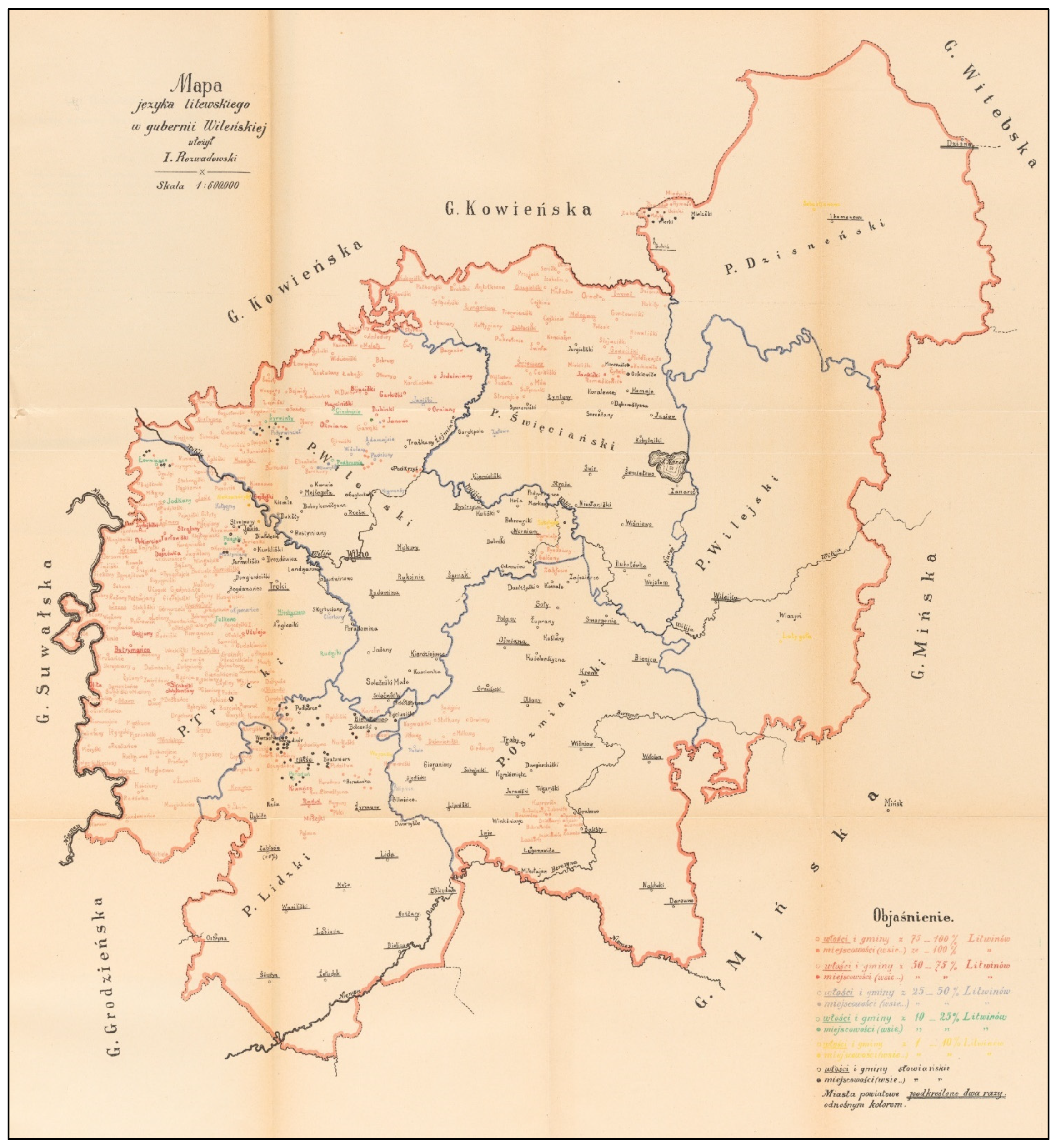
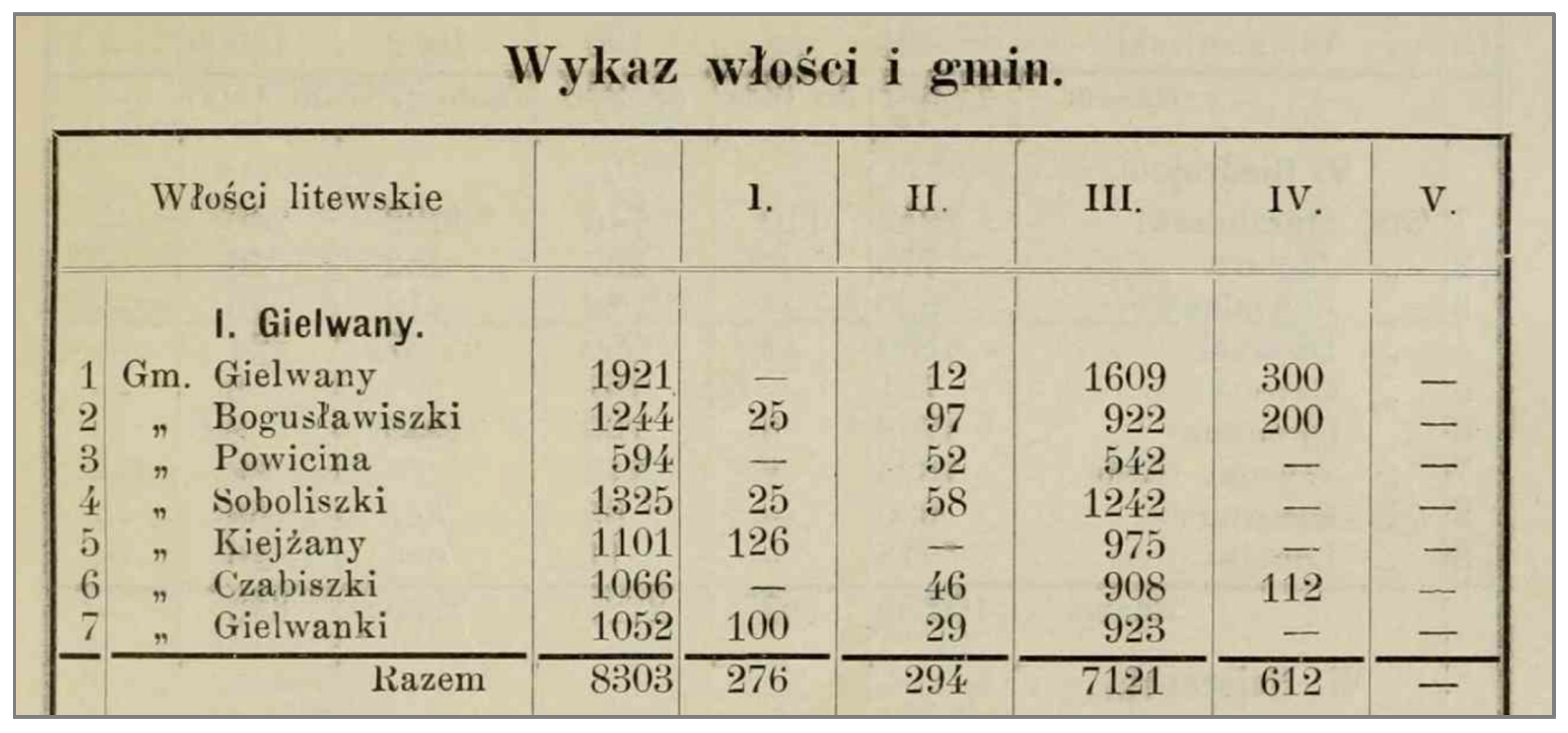
- Rozwadowski, Jan Michał. 1901. Mapa Języka Litewskego w Gubernii Wilenskiej [Map of the Lithuanian Language in Vilnius Governorate]. Materiały i Prace Komisii językowej Akademii Umiejętności w Krakowe. Krakow: Nakładem Akademii Umiejętności. Krakow: Biblioteka Jagiellońska, Tomas Nenartovic. Available online: https://lithuanianmaps.com/images/1901_19_Rozwadowski_COMP15.jpg (accessed on 6 November 2024).
- Rozwadowski, Jan Michał. 1904. Objaśnienia do Mapy Języka Litewskego w Gubernii Wilenskiej [Explanations of the Map of the Lithuanian Language in Vilnius Governorate]. Materiały i Prace Komisii Językowej Akademii Umiejętności w Krakowe. Krakow: Nakładem Akademii Umiejętności, pp. 89–94. [Google Scholar]
- State Data Agency of Lithuania. 2011a. Geospatial Data on 1 × 1 km Grids from the 2011 Population and Housing Census of the Republic of Lithuania. Available online: https://open-data-sets-ls-osp-sdg.hub.arcgis.com/datasets/7fec4f1e8a73428283ea9e906aa89483_0/about (accessed on 6 November 2024).
- State Data Agency of Lithuania. 2011b. Results of the 2011 Census of Population and Housing of the Republic of Lithuania. Available online: https://osp.stat.gov.lt/documents/10180/217110/Gyv_kalba_tikyba.pdf/1d9dac9a-3d45-4798-93f5-941fed00503f (accessed on 6 November 2024).
- State Data Agency of Lithuania. 2021a. Population and Housing Census 2021—Population (GRID 1 km). Available online: https://open-data-sets-ls-osp-sdg.hub.arcgis.com/datasets/80272a0f7a7e4905bc379f0ae921e5b7_1/about (accessed on 6 November 2024).
- State Data Agency of Lithuania. 2021b. Population by Ethnicity in Municipality. Available online: https://osp.stat.gov.lt/en/statistiniu-rodikliu-analize?hash=0078cd86-acd6-46a8-9843-623bdf998aba#/ (accessed on 6 November 2024).
- State Data Agency of Lithuania. 2021c. Population by Mother Tongue in Municipality. Available online: https://osp.stat.gov.lt/en/statistiniu-rodikliu-analize?hash=03d78029-cb87-40e8-aff0-0b00b868015e#/ (accessed on 6 November 2024).
- State Data Agency of Lithuania. 2021d. Population by Nationality, Mother Tongue and Religion (Metadata). Available online: https://osp.stat.gov.lt/documents/10180/5118910/Gyventojai+%5BEN%5D+490.html (accessed on 6 November 2024).
- Vidugiris, Aloyzas. 1993. Etnolingvistinė Pietryčių Lietuvos Padėtis XX a. Pirmojoje Pusėje [Ethnolinguistic Situation of South-Eastern Lithuania in the First Half of the 20th Century]. Edited by Lietuvos Rytai, K. Garšva and L. Grumadienė. Vilnius: State Publishing Centre, pp. 115–31. [Google Scholar]
- Waters, Nigel. 2017. GIS: History, The International Encyclopedia of Geography. Edited by Douglas Richardson, Noel Castree, Michael F. Goodchild, Audrey Kobayashi, Weidong Liu and Richard A. Marston. Hoboken: John Wiley & Sons, Ltd., pp. 2–12. [Google Scholar]
- Wroblewski Library of the Lithuanian Academy of Sciences. 2019. Topographic Maps of Lithuania for 1914–1945. Available online: https://maps-lmavb.hub.arcgis.com/pages/topo (accessed on 6 November 2024).
- Zinkevičius, Zigmas. 1993. Pietryčių Lietuva nuo Seniausių Laikų iki Mūsų Dienų [Southeastern Lithuania from Ancient Times to the Present]. Edited by Lietuvos Rytai, K. Garšva and L. Grumadienė. Vilnius: State Publishing Centre. [Google Scholar]
- Zinkevičius, Zigmas. 1998. The History of the Lithuanian Language. Vilnius: Institute of Science and Encyclopedia Publishing. [Google Scholar]
- Zinkevičius, Zigmas. 2006. Lietuvių Tarmių Kilmė [The Origin of Lithuanian Dialects]. Vilnius: Publishing House of the Institute of the Lithuanian Language. [Google Scholar]


Disclaimer/Publisher’s Note: The statements, opinions and data contained in all publications are solely those of the individual author(s) and contributor(s) and not of MDPI and/or the editor(s). MDPI and/or the editor(s) disclaim responsibility for any injury to people or property resulting from any ideas, methods, instructions or products referred to in the content. |
© 2024 by the author. Licensee MDPI, Basel, Switzerland. This article is an open access article distributed under the terms and conditions of the Creative Commons Attribution (CC BY) license (https://creativecommons.org/licenses/by/4.0/).
Share and Cite
Gudaitis, A. The Application of Geospatial Analysis Methods for the Reconstruction of Lithuanian–Slavic Ethnolinguistic Boundaries in Southeastern Lithuania. Languages 2024, 9, 359. https://doi.org/10.3390/languages9120359
Gudaitis A. The Application of Geospatial Analysis Methods for the Reconstruction of Lithuanian–Slavic Ethnolinguistic Boundaries in Southeastern Lithuania. Languages. 2024; 9(12):359. https://doi.org/10.3390/languages9120359
Chicago/Turabian StyleGudaitis, Aidas. 2024. "The Application of Geospatial Analysis Methods for the Reconstruction of Lithuanian–Slavic Ethnolinguistic Boundaries in Southeastern Lithuania" Languages 9, no. 12: 359. https://doi.org/10.3390/languages9120359
APA StyleGudaitis, A. (2024). The Application of Geospatial Analysis Methods for the Reconstruction of Lithuanian–Slavic Ethnolinguistic Boundaries in Southeastern Lithuania. Languages, 9(12), 359. https://doi.org/10.3390/languages9120359