Article

Glacio-Nival Regime Creates Complex Relationships between Discharge and Climatic Trends of Zackenberg River, Greenland (1996–2019)

1
Department of Physical Geography, Stockholm University, 106 91 Stockholm, Sweden
2
Institute of Geography, Heidelberg University, 69120 Heidelberg, Germany
*
Author to whom correspondence should be addressed.
These authors contributed equally to this work.
Climate 2021, 9(4), 59; https://doi.org/10.3390/cli9040059
Submission received: 9 March 2021 / Revised: 28 March 2021 / Accepted: 6 April 2021 / Published: 8 April 2021

Abstract

:
Arctic environments experience rapid climatic changes as air temperatures are rising and precipitation is increasing. Rivers are key elements in these regions since they drain vast land areas and thereby reflect various climatic signals. Zackenberg River in northeast Greenland provides a unique opportunity to study climatic influences on discharge, as the river is not connected to the Greenland ice sheet. The study aims to explain discharge patterns between 1996 and 2019 and analyse the discharge for correlations to variations in air temperature and both solid and liquid precipitation. The results reveal no trend in the annual discharge. A lengthening of the discharge period is characterised by a later freeze-up and extreme discharge peaks are observed almost yearly between 2005 and 2017. A positive correlation exists between the length of the discharge period and the Thawing Degree Days ( r = 0.52 , p < 0.01 ), and between the total annual discharge and the annual maximum snow depth ( r = 0.48 , p = 0.02 ). Thereby, snowmelt provides the main source of discharge in the first part of the runoff season. However, the influence of precipitation on discharge could not be fully identified, because of uncertainties in the data and possible delays in the hydrological system. This calls for further studies on the relationship between discharge and precipitation. The discharge patterns are also influenced by meltwater from the A.P. Olsen ice cap and an adjacent glacier-dammed lake which releases outburst floods. Hence, this mixed hydrological regime causes different relationships between the discharge and climatic trends when compared to most Arctic rivers.

1. Introduction

Various components of the Arctic system are characterised by rapid climate changes, which are mainly driven by increases in air temperature more than twice the global average [1]. An intensification of the hydrological cycle is observed coherent with the increase in air temperature, which is reflected by increases in humidity, precipitation and river discharge [2]. River discharge is a major source of freshwater to the Arctic ocean, as it receives more than 10% of the global river discharge, while the Arctic ocean only contains around 1% of the global ocean volume [3]. The relatively warm freshwater influx is influencing the thermohaline ocean circulation and affecting regional sea ice formation [4,5]. In addition, river inputs of nutrients and organic matter influence the coastal ecological productivity [3,6].
Arctic-draining rivers in Eurasia and North-America show an increase in freshwater discharge to the Arctic ocean, which is frequently accompanied by a shift towards an earlier start of the melt season [7,8]. Several explanations have been suggested for this increase, although the contributions of the individual processes have been difficult to determine. An increase in atmospheric moisture content resulting in more precipitation is often proposed as the main cause of the increasing river discharges [9,10]. Other explanations are the negative mass balances of glaciers which on short-term contribute extra water to rivers downstream [11], and increased groundwater contribution due to permafrost thaw [12,13]. Meltwater-fed rivers outside of the Arctic region show varying discharge trends [14,15,16].
It should be pointed out that the majority of precipitation in the Arctic falls and is stored as snow, and therefore snowmelt in spring contributes significantly to river discharge [17]. However, Bintanja and Andry [18] project a decrease in snow for the future Arctic, as a greater proportion of precipitation will likely fall as rain. A decrease in the snow cover extent and length have already been observed for the Arctic, but seem to mostly affect the timing of the discharge [2,19].
The largest Arctic-draining river watersheds (e.g. Mackenzie, Ob, Lena and Yenisei), originating from North-America and Eurasia, have been the most extensively studied rivers [8,20]. But studies on the discharge of Arctic rivers in Greenland are scarce, even though the Greenland ice sheet (GrIS) is currently the largest contributor to freshwater flux into the global ocean [1]. Although the GrIS loses significant amounts of its mass through solid ice discharge, the total mass loss of the GrIS is dominated by meltwater runoff since recent years [21,22]. Long-term discharge monitoring of proglacial rivers, such as the Watson River and the Zackenberg River, allow for insights into the discharge patterns of Greenlandic rivers, and thus into the meltwater runoff [23,24].
Zackenberg River in northeast Greenland provides the longest discharge record from Greenland, although the proglacial river is not connected to the ice sheet itself. Yet, local glaciers and ice caps outside the GrIS are expected to have a strong impact on the freshwater flux [25]. As the Zackenberg River is not influenced by ice sheet melt processes, this potentially allows for a better examination of the effect of other climatic parameters on the discharge, such as air temperature, precipitation and snowmelt. In addition, due to its remote location Zackenberg River is not influenced by water management practices, while it is observed that dam constructions and reservoirs influence discharge patterns [20,26]. A study on the discharge of Zackenberg River indicated an increase in annual discharge over the period of 1996 to 2003 [27]. The discharge measurements of Zackenberg River are currently available up to 2019, which offers the opportunity to reassess trends in river discharge for the last 24 years. The discharge measurements are well-suited for studies on long-term climate-induced discharge variability.
The aim of this paper is to describe the changes in discharge patterns in terms of the total discharge volume, peak discharge, timing of the river break-up and freeze-up and length of the entire discharge period of the Zackenberg River between 1996 and 2019. The discharge properties are analysed for correlations to variations in air temperature and precipitation (including snow properties), as these are considered the main drivers of many changes in the Arctic system [1]. The findings are compared to the study of Mernild et al. [27] to assess how the observed trends for the period between 1996 and 2003 have developed in the following years until 2019. The analysis indicates that the increasing trend in discharge, as observed by Mernild et al. [27] until 2003, did not persist. This study aims for providing explanations for this observed change in the discharge trend by means of the correlations to air temperature and precipitation.

2. Study Area

Zackenberg Research Station (74°28′07″ N, 20°34′00″ W, Figure 1), which is owned by the Government of Greenland and run by the University of Aarhus, was established in 1995 and officially opened in 1997 [28]. It is located in the northeast of Greenland, 90 km east from the GrIS at an elevation of 38 m a.s.l. [28,29].
The research station is built in the Zackenberg Valley next to the Zackenberg River, which flows into the Young Sound-Tyrolerfjord. The valley runs along an 8 km long north-south geological fault zone [29] with the Zackenberg mountain (1372 m a.s.l.) on the western side and the Aucellabjerg Mountain (911 m a.s.l.) on the eastern side of the valley [29,32].
The drainage basin of the Zackenberg River (514 km2), which varies in altitude between 0 and 1450 m a.s.l., includes Zackenbergdalen, Store Sødal, Lindemansdalen and Slettedalen [33]. The drainage area is 20% covered by glaciers at elevations above 1000 m a.s.l. The A.P. Olsen ice cap covers an area of 295 km2 and is located 35 km northwest of Zackenberg. A marginal, glacier-dammed lake of the ice cap causes episodical flood waves into Zackenberg River [34]. The proglacial Zackenberg River is not connected to the GrIS, which means the discharge is not directly influenced by processes on the ice sheet [32]. The drainage area of Zackenberg River is not significantly influenced by groundwater [35].
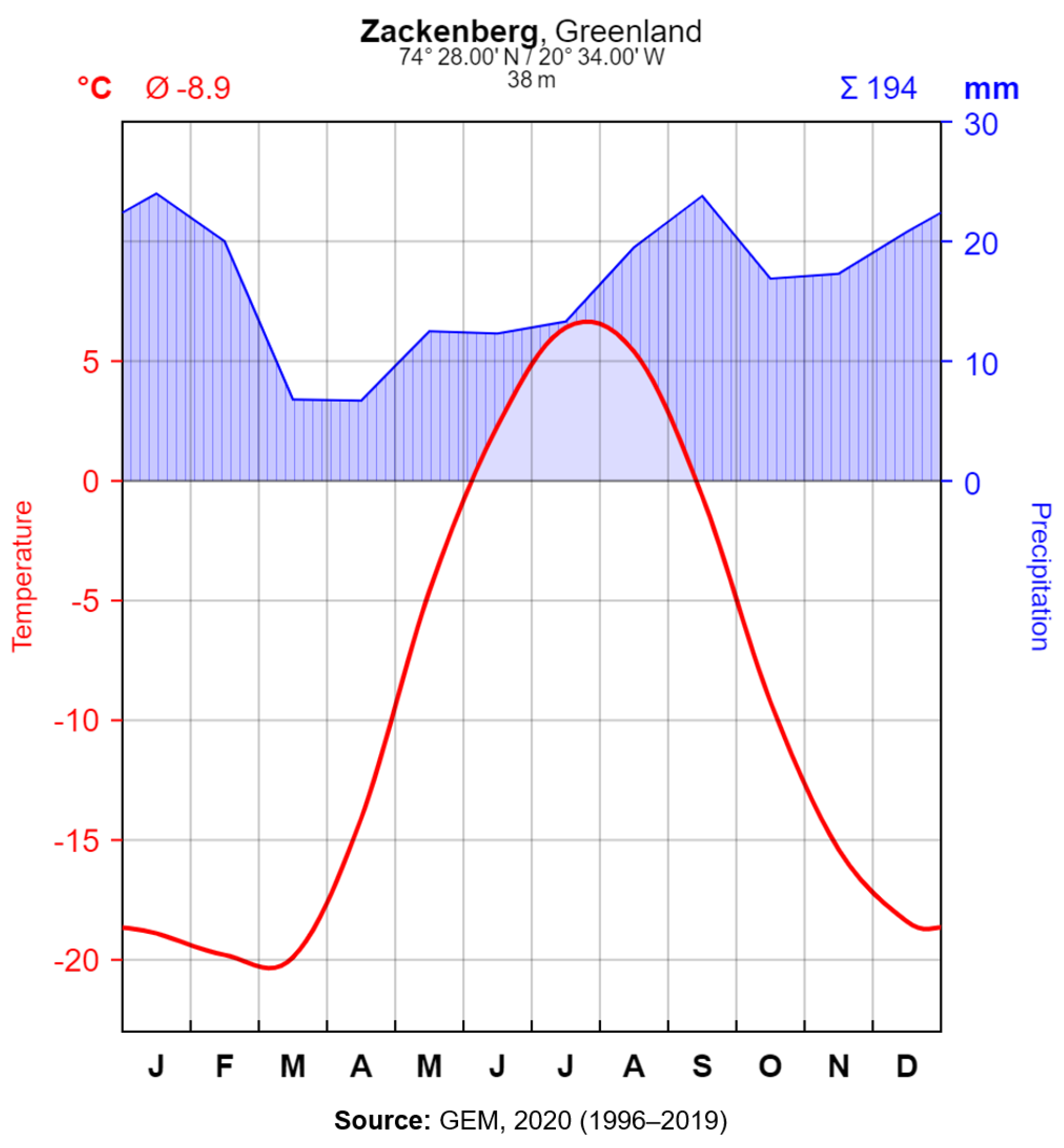
The mean annual air temperature (MAAT) is −8.9 °C and the average annual precipitation is 194 mm (Figure 2). On average 75% of the precipitation falls as snow [36], which forms a continuous winter snow cover starting between the beginning of September and the end of October until mid-late June [32]. The availability of water in the growing season is mainly controlled by the melting of large snow patches, as the summer precipitation is low [37]. The vegetation in the valley consists of shrubby Cassiope [38]. A numerical model calculated the permafrost thickness in the area to be 200 m to 300 m in the valley and 300 m to 500 m in the mountains [39]. The hydrological regime of the Zackenberg drainage basin is classified as glacio-nival, but some parts, which are especially close to the glaciers, are purely glacial regimes [32].

3. Methods

3.1. Data Measurements

In this study hydrological and meteorological data from the GEM (Greenland Ecosystem Monitoring) programme is used to observe the discharge patterns of Zackenberg River and to find correlations between discharge and climatic conditions. The GEM involves long-term monitoring and research of ecosystems and climate change effects at three different stations (Nuuk, Disko and Zackenberg) in Greenland [42]. This study uses data from Zackenberg including river discharge [43], air temperature [40], precipitation [41] and snow depth [44].
The discharge is calculated through water-level measurements, which are taken every 15 min by two radar sensors since 1996. The established water-level–discharge relationship is controlled by manual discharge measurements throughout the year. These are conducted with water flow velocity measurements with either a Q-liner or a Valeport electromagnetic flow meter. Since the river bed changes naturally, the water-level–discharge relationship is recalculated regularly [45].
Zackenberg River completely freezes-up during winter, which means that there is no under-ice discharge during this time. Manual discharge measurements are important after river break-up and before freeze-up, when the river bed is covered with snow and ice, since the water level cannot be measured by the automatic sensors in this case. The discharge between manual measurements are interpolated values [45]. The date of the river break-up corresponds to the date when the first streamflow is observed after the winter and the freeze-up to the date when the last streamflow is noticed before winter. Since Zackenberg Research Station is not manned during winter the monitored dates of river break-up and freeze-up are limited to the staffed season where observations are carried out (K. Langley, personal communication, 15 February 2021). In the case of flood events the discharge is extrapolated, wherefore these peak values are statistical estimations [45].
Air temperature and precipitation monitoring in the valley started in August 1995 [38]. Air temperature is measured at two masts, which are ca. 10 m apart from each other (primary station 640 at 74°28′18.9″ N, 20°33′7.5″ W, 44 m a.s.l. and secondary station 641 at 74°28′18.8″ N, 20°33′8.6″ W, 43 m a.s.l.). The two available stations allow comparison and correction of the temperature values. Air temperature recordings are conducted with a Vaisala HMP 45D sensor 200 cm above ground and are given in 60 min average values [46].
The accumulated precipitation is measured hourly with two precipitation gauges close to station 640/641 [46]. The first installation only recorded liquid precipitation [38], therefore a snow-water–equivalent was calculated from snow depth measurements [27]. In 2010 it was reported that an Ott PLUVIO gauge (1.0 m above ground) and a Belfort 5915 × gauge (1.5 m above ground) were installed [46]. The most recent monitoring manual reports two PLUVIO gauges for precipitation measurements [47]. Belfort and PLUVIO gauges both weigh the precipitation to measure the accumulated precipitation, which makes it possible to monitor precipitation in its liquid and solid phase [48]. Due to the changes in the method of precipitation monitoring and reports about missing values in 2010 and 2014 [49] caution is suggested with the precipitation values.
Snow depth monitoring in Zackenberg started in 1997 [50]. The observation site lies ca. 30 m north of station 640/641 [47]. Data is monitored every three hours with a sonic range sensor (Campbell SR 50-45) ca. 1.8 m above ground [46]. The representation of the snow depth measurements for the drainage basin might be limited due to the heterogeneous topography. Snow depth is only recorded at one station in the valley and these measurements potentially differ from other locations due to snowdrift [45] and accumulation differences. However, it is expected that the snow depth monitoring location in the valley is representative for the entire drainage basin.

3.2. Data Analysis

Following Mernild et al. [27] Thawing Days (TD) and Thawing Degree Days (TDD) were calculated to analyse the correlation of river discharge to air temperature. Thereby, TD were calculated as the sum of days of a year where the daily mean air temperature was above 0 °C. TDD were calculated by summing up the daily mean air temperatures of a year where temperatures were above 0 °C. The values of TD and TDD are expected to influence the discharge patterns of the river, since thawing conditions cause the melt of the accumulated snow of the drainage area [27]. Therefore, the length of continuous snow cover (with snow depth ≥ 1 cm) and the max. snow depth (daily average) were calculated for each winter season.
Cumulative CO2 emissions are almost in a linear relationship with global mean surface temperatures [51]. Therefore, simple linear regression was used to calculate a linear equation describing a particular variable throughout the observation period. The strength of the linear relationship is indicated by the squared residual (R2). The Pearson’s correlation coefficient (r) was used to describe the direction and strength of a linear relationship between two independent variables, in this case between particular discharge properties and the other parameters. The p-value was calculated to assess whether the correlations are statistically significant. The significance level ( α ) is set to 0.05, which means all correlations with p-values below 0.05 are considered to be statistically significant.

4. Results

4.1. Hydrological Parameters

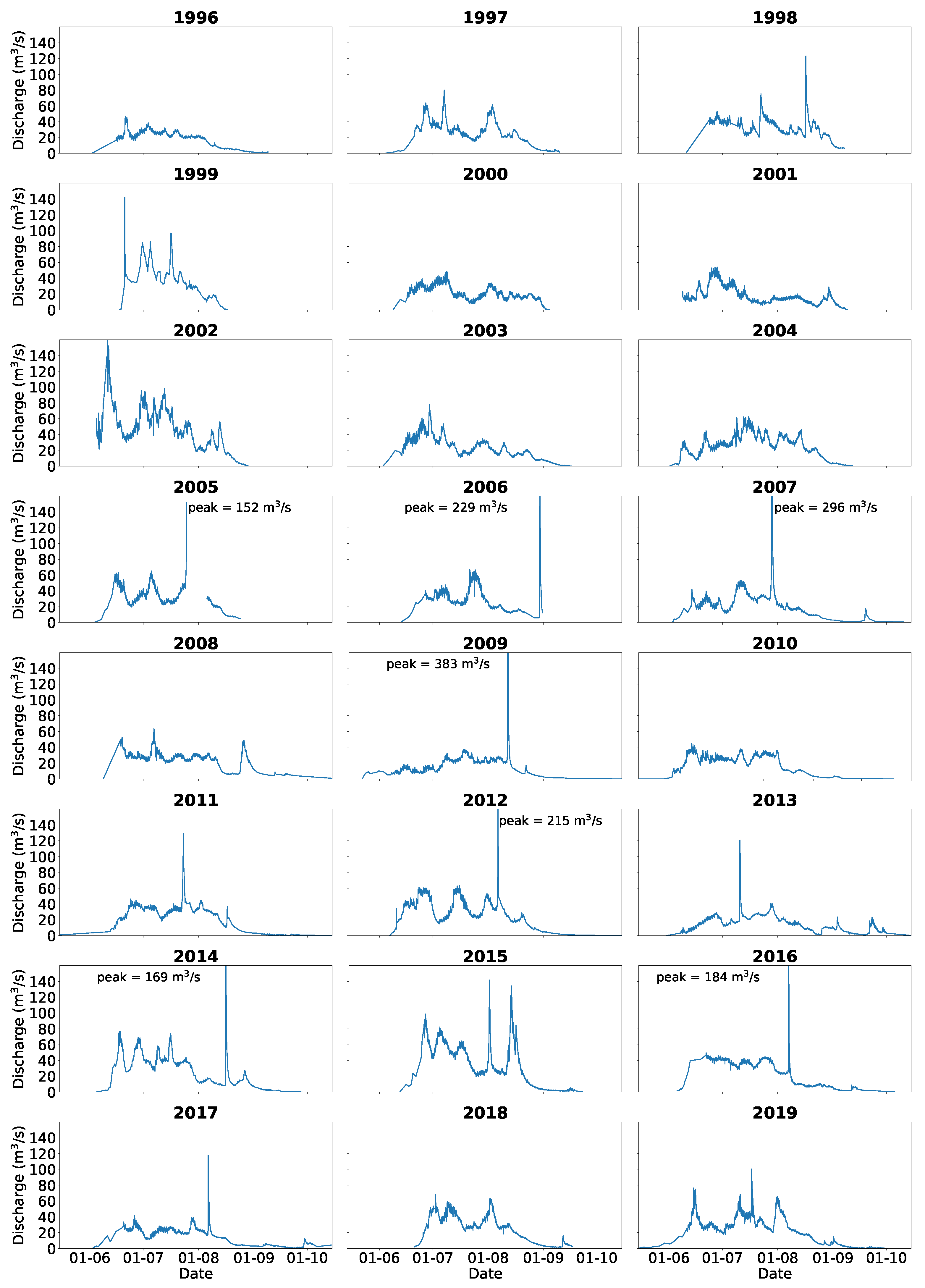
The discharge measurements between 1996 and 2019 are visualised in annual hydrographs (Figure 3). The discharge generally varied between 20 m3 s−1 and 60 m3 s−1, excluding the low values during the river break-up at the beginning of the season and the freeze-up at the end of the season. A visual examination of the hydrographs demonstrates multiple peaks in the discharge. Extreme peak discharge events (>150 m3 s−1) occurred almost every year between 2005 and 2017, except for 2008 and 2010. These extreme events generally occurred at the end of July or in August. The highest peak discharge occurred in 2009 with an estimated discharge of 383 m3 s−1, while the lowest peak discharge occurred in 2010 with a discharge of 45 m3 s−1. Linear regression analysis reveals an increase in peak discharge of 2.4 m3 s−1 yr−1, but the variation cannot be explained by the regression model.
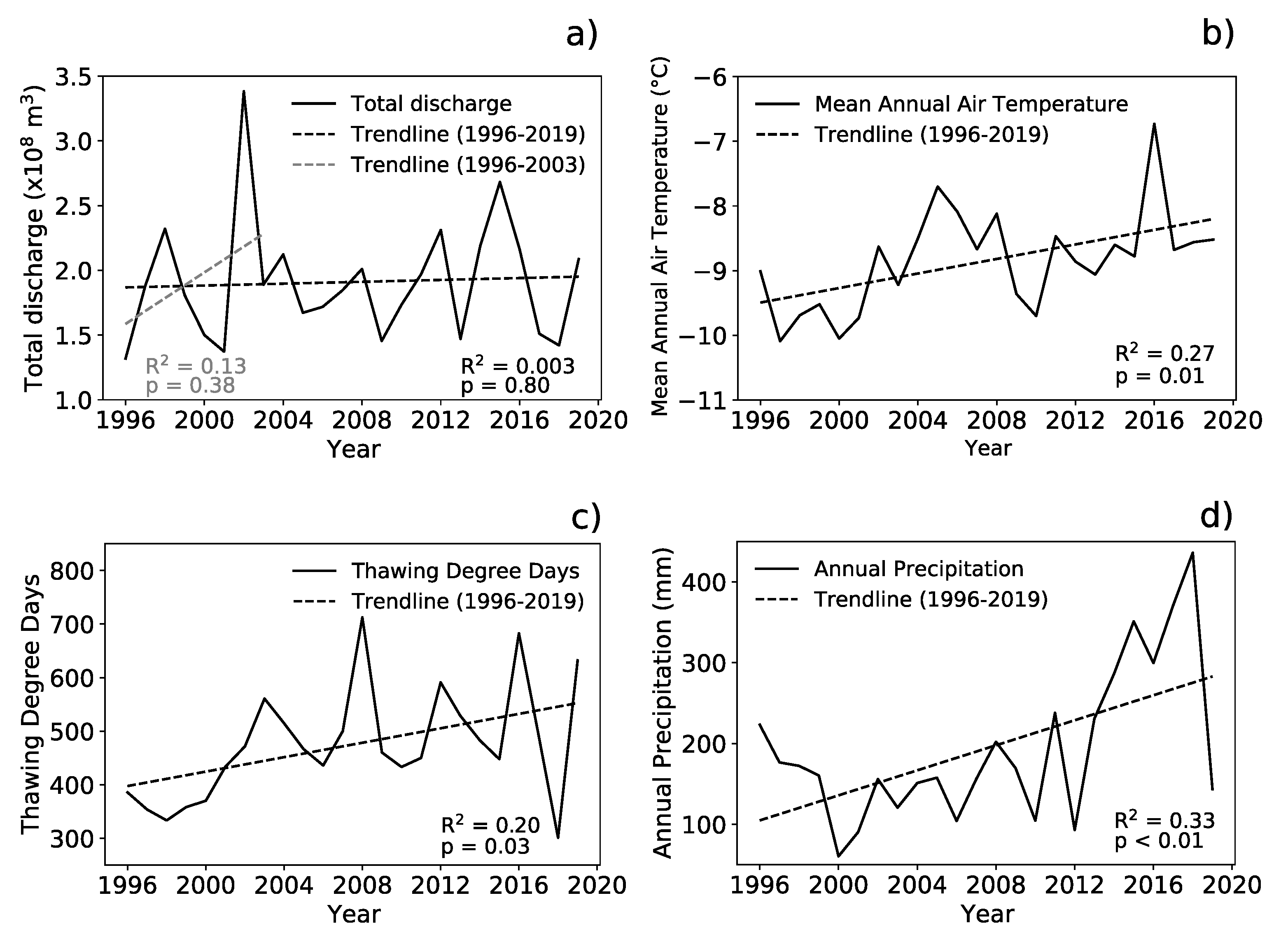
The average total annual discharge between 1996 and 2019 is 1.9 × 10⁸ m3 and varies between 1.3 × 10⁸ m3 (1996) and 3.4 × 10⁸ m3 (2002). Above 70% of the total discharge occurs in June and July. A linear regression analysis demonstrates a negligible linear trend between 1996 and 2019, with an increase of 0.004 × 10⁸ m3 yr−1, but the variation in discharge cannot be explained by the linear model (Figure 4a).
The river break-up during the observation period ranged between 8 May in 2011 (day of the year 128) and 20 June in 2018 (day of the year 171), but generally occurred in the beginning of June (Figure 5). The river typically froze over at the end of August or the beginning of September between 1996 and 2006 and around mid-October since 2007. The average length of the river discharge period was 112 d, and varied between 61 d (1999) and 160 d (2011). Linear regression analysis shows that the river discharge period increased around 2.2 d yr−1 ( R 2 = 0.33 ), which was mainly caused by the extension of the period into autumn (Figure 5). The river break-up does not appear to be starting significantly earlier throughout the observation period.

4.2. Meteorological Parameters

4.2.1. Air Temperature

The mean air temperature of the observation period is −8.9 °C and is normally above 0 °C from June to mid-September (Figure 2). The MAAT varies between the coldest MAAT of −10.09 °C measured in 1997 and the warmest MAAT of −6.73 °C measured in 2016. The linear regression analysis indicates an increase in MAAT by 0.056°C yr−1 ( R 2 = 0.27 ; Figure 4b). The max. air temperature which was measured in the period from August 1995 to December 2019 was 22.9°C and occurred on 21 July 2006. The min. air temperature of −38.9°C was measured on 23 February 1998.
The study period is characterised by an average of 104 TD in a year. TD reached their min. with 89 d in 2000, while TD reached their max. with 123 d in 2016. For the study period TD shows an increasing trend of 0.6 d yr−1 ( R 2 = 0.20 ). The observation period is characterised by on average 475 TDD in a year. The max. TDD reached 712 in 2008, while the min. TDD of 301 occurred in 2018. A considerable increasing trend in TDD of 6.7 yr−1 is observed ( R 2 = 0.20 ; Figure 4c).

4.2.2. Precipitation

The average annual precipitation in the period between 1996 and 2019 is 194 mm (Figure 2). The year with most precipitation was 2017 with 371 mm and the year with least precipitation was 2000 with 60 mm. In general, there is relatively little precipitation during the year and it varies between the max. monthly average precipitation in January with 24 mm and the min. monthly average precipitation in March and April with 7 mm. The linear regression reveals an increase in total precipitation of 7.7 mm yr−1 between 1996 and 2019 ( R 2 = 0.33 ; Figure 4d). Caution must be given to the fact of missing values in the precipitation data for the years 2010 and 2014. The total precipitation sums for these two years therefore only indicate a minimum estimation of precipitation [49].

4.2.3. Snow Cover and Depth

A continuous snow cover exists on average 257 d per winter season in the study period 1997–2019. The shortest snow cover length is observed in the winter of 2008/2009 with 167 d, while the longest snow cover lasted 314 d in 1998/1999. The trend in the snow cover period shows a lengthening by 0.6 d yr−1 ( R 2 = 0.01).
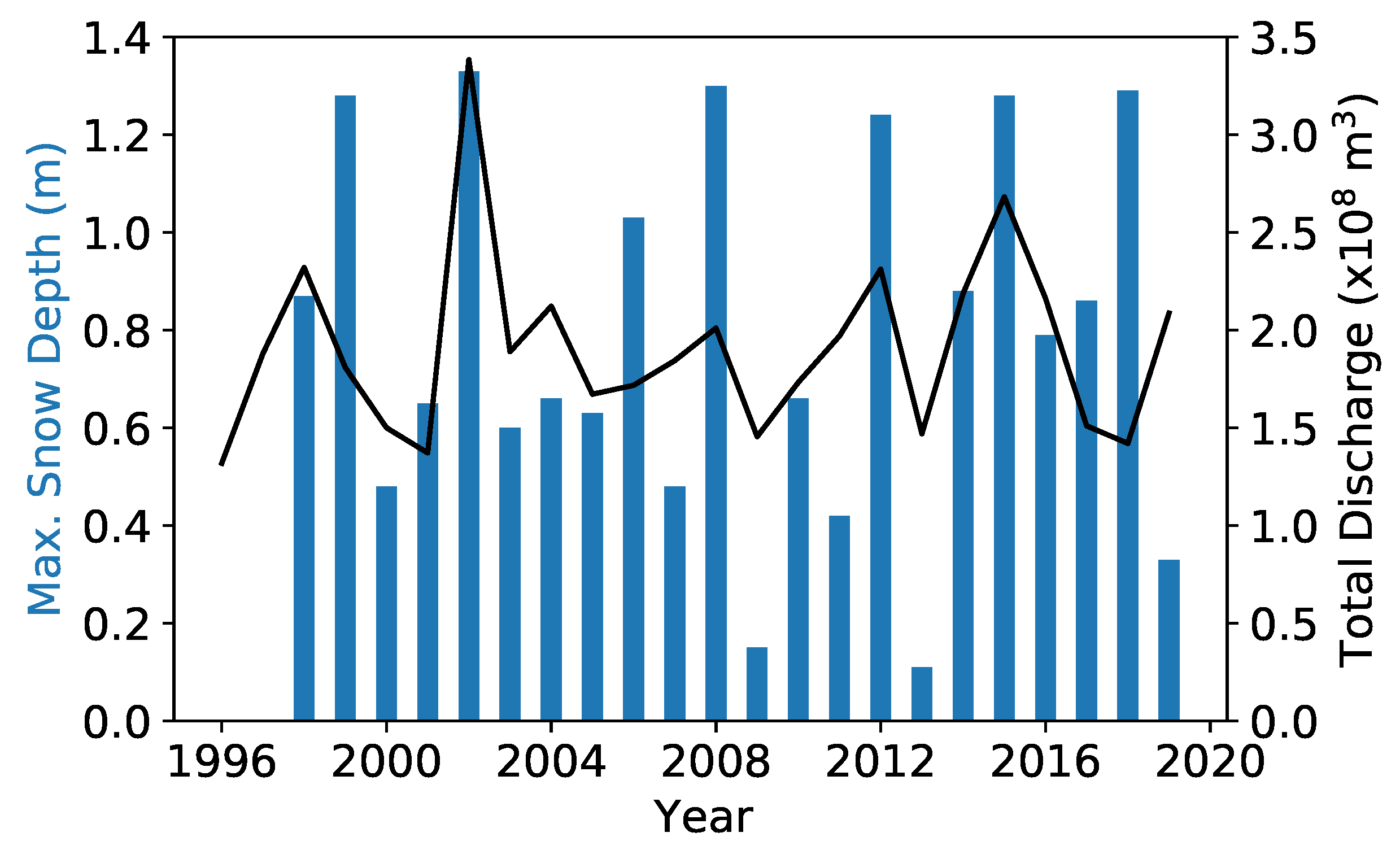
The max. snow depth in the study period was 1.33 m and occurred on 15 April 2002 (Figure 6). In the season 2012/2013 the smallest max. snow depth measured was 0.11 m on 30 March 2013. On average the max. snow depth of a winter season was 0.79 m. Linear regression analysis reveals a negligible trend in max. snow depth (−3 mm yr−1), but the variation cannot be explained by the regression model. The max. snow depth was reached between March and May. An exceptionally early max. snow depth of 0.33 m was measured on 21 January 2019.

4.3. Correlations

In Table 1 the calculated correlations are given in order from high to low correlation coefficients (r) with their corresponding p-value. The Pearson’s correlation shows a significant moderate positive relationship between the length of the discharge period and the TDD. Another significant moderate positive relationship is found between the total annual discharge and the annual max. snow depth. A significant moderate negative relationship is found between the daily average discharge and the daily average air temperature. A weak positive relationship is found between the total annual discharge and MAAT, but the high p-value indicates this relationship is not statistically significant. No correlation is found between the discharge data and the precipitation data.

5. Discussion

5.1. Trends in Discharge and Meteorological Parameters

Zackenberg River discharge reveals neither an increasing nor a decreasing trend in the 24-year monitoring period. Mernild et al. [27] described an increasing discharge over the period 1996–2003, as also visualised in Figure 4a. However, this trend does not continue over a longer observation period.
The observed increasing air temperature trend by ca. 0.06 °C yr−1 by Mernild et al. [27] remained stable for the study period 1996–2019. The relatively high negative correlation between the daily discharge and the air temperature might be the result of leads or lags in the system, as changes in air temperature might not be recorded in the river discharge within the same day. Total annual discharge only shows a very weak correlation with the MAAT and a similar low correlation exists between the total annual discharge and TDD. This does indicate a certain influence by the air temperature, as warmer temperatures align with a higher discharge. It is reasonable that the connecting factor of this weak relationship between air temperatures and discharge is the A.P. Olsen ice cap. Namely, increasing temperatures are followed by increasing melting rates of the glacier and thus intensified discharge. Furthermore, a positive TDD trend is an important factor for the lengthening of the discharge period.
Snow is an important contributor to the annual discharge of Zackenberg River (Figure 6). The snowmelt contributes most discharge in the first half of the runoff season, and since summer precipitation is generally low, most discharge is observed in the first part of the runoff season. The snow depth remained relatively stable throughout the observation period, which might explain the lack of trend in the discharge of the nival-dominated river. After snowmelt, it is primarily the glacier in the drainage area which contributes high amounts of discharge in late summer. Citterio et al. [52] report that almost 40% of the discharge originates from the A.P. Olsen ice cap during that time.
The recurring events of extreme discharge, probably caused by glacial lake outburst floods (GLOFs) originating from a glacier-dammed lake near the A.P. Olsen ice cap, contribute high proportions of water to the annual discharge as well. Between 2009 and 2013 5% to 10% of the annual discharge originated from GLOFs [35]. The GLOFs occur approximately with an annual cycle in the Zackenberg region [34] and seem to be timed with the max. active layer thickness of the particular season [35]. There is still no agreement whether climate warming will raise the probability of GLOFs and their intensity due to melting glaciers [53] or whether increasing temperature will not impact the frequency, magnitude and timing of GLOFs as long as the glaciers exist [35].
Difficulties are encountered when examining the relationship between the increasing precipitation trend and the discharge, which can be explained by a combination of factors. Mernild et al. [27] observed no precipitation trend between 1996 and 2003, but over the 24-year observation period precipitation sums did increase (Figure 4d). As described in Section 3.1, the precipitation data exhibits uncertainties due to changes in the monitoring procedure and missing data. Furthermore, the measurement of precipitation in cold climates faces many challenges due to the extreme conditions, like accidentally catching blowing snow in gauges [54]. Therefore, the precipitation sums may come with high errors, which leaves the question for a reliable trend in precipitation unsolved, especially as a less pronounced increasing trend in precipitation is found over the observation period when considering the higher reported precipitation values between 1996 and 2007 by Jensen et al. [49] than the data of GEM [41] used in this study.
A delay in the transfer of the precipitation signal to the discharge can be caused in different ways. Since most precipitation falls as snow, a time lag occurs between the precipitation event and the melt of snow which contributes to the discharge. This time lag in most cases is several months long, if new snow in autumn melts in the following year. Moreover, precipitation is stored in the ice cap, lakes and possibly in soils. For example, precipitation is partly stored in the lake in Store Sødal and the glacier-dammed lake, which can cause a delay in the runoff at the downstream part of Zackenberg River where discharge is measured. The precipitation signal can also be weakened by water evaporation from the lake surfaces, although this effect is probably minimal considering the cold summer temperatures.
The missing signal of increasing precipitation in the discharge record could be explained by a shift from solid towards liquid precipitation as an effect of rising temperatures in Zackenberg. It is predicted that precipitation in Greenland will stay dominated by snow fall [18], but the proportion of rain precipitation events is likely to increase in Zackenberg [55]. Berghuijs et al. [56] observed that a shift towards snow causes higher discharge rates in rivers, which implies lower discharge rates could occur for the Zackenberg River with a shift towards rain. In this way the relationship between the increasing precipitation (including both rain and snow) and the discharge is obscured. Unfortunately, the precipitation data is not separated in rain and snow, and it is therefore difficult to determine whether a shift towards rain has already occurred.
Overall, the discharge of Zackenberg River has a high dependency on snowmelt, glacier melt and flood events. These factors, combined with a time lag of the precipitation runoff and problems with the data, make it difficult to follow the signal of precipitation in discharge. Only the snowmelt shows a statistically significant influence of precipitation on discharge.

5.2. Comparison to Other Studies

A comparison is made to other rivers in Greenland, the Arctic and other regions to find explanations for differences in the discharge patterns across the Arctic. However, differences in scale, geology, topography and latitude between the river basins complicate the comparison. Furthermore, the global warming trend has changed in strength throughout the 20th century [57], which is important to consider when comparing trends from studies with different observation periods.
Various studies on discharge trends for Greenlandic rivers seem to contradict each other. A reconstruction of the discharge of the Watson River, which is connected to the GrIS, between 1946 and 2017 by van As et al. [24] showed that the total discharge increased, which was explained by intense ice sheet melting and an extended melt season. However, a study by Overeem et al. [58] showed that the total discharge of both the Watson River and Naujat Kuat River, derived from satellite data (MODIS), demonstrated no significant increasing trend over the 2000–2012 record.
Overeem et al. [58] suggest the lack of trend might be caused by water storage within the glacio-hydrological system, which might be applicable to the Zackenberg River discharge as well. Melt from the A.P. Olsen ice cap is captured in a lake in Store Sødal upstream of Zackenberg River (Figure 1). This temperature-derived signal might therefore not be directly transferred to the discharge measured downstream. Nonetheless, it is important to note that both the Watson and Naujat Kuat rivers are ice sheet-marginal rivers, so the influence by the ice sheet is not comparable to the influence of the A.P. Olsen ice cap to the Zackenberg River.
In contrast to the discharge trend of Zackenberg River, increasing annual discharge trends have been observed for the majority of rivers in the Arctic: for Eurasian rivers for 1936–1999 [59], for northern Canadian rivers for 1975–2013 [60], for rivers across the entire Arctic for 1977–2007 [7] and for the four largest rivers in the Arctic for 1980–2009 [8]. Regarding the timing of the discharge, the spring stream flows are occurring earlier in the year and extending later into the year, as found for Eurasian Arctic rivers (1958–1999) by Tan et al. [19], for the four largest rivers in the Arctic (1980–2009) by Ahmed et al. [8] and across northern Canada (1964–2015) by Shiklomanov et al. [20]. In comparison, Zackenberg River is characterised by a later freeze-up instead of an earlier river break-up, perhaps due to an increase in TDD. Extension of the discharge period by late-summer rain events as observed by Ahmed et al. [8] for Eurasian rivers (1980–2009) has probably not occurred yet for Zackenberg River, but might as well be realistic in the future.
Rivers fed by meltwater outside of the Arctic demonstrate varying trends. River basins in the Himalayas do not show trends in the discharge (1962–2000), although the lack of good-quality data limits the analysis of trends and the monsoon influences the discharge [14]. A glacier-fed river basin in the Andes of Chile shows a decreasing trend in discharge for 1955–2016 [16], while rivers in the European Alps with glacial regimes show an increase in discharge and an increased duration of snowmelt flow [15]. Many different factors influence the discharge, so naturally glacial rivers around the globe do not respond similar to climate change and therefore do not show the same response as Zackenberg River in Greenland.
The most proposed explanation for the increasing discharge is an increase in moisture transport due to sea ice decline and the resulting changes in precipitation patterns [20,61]. The majority of the discharge from Arctic rivers is originating from (spring) snowmelt [8], and thus especially increases in winter precipitation (as in Western Siberia and the Canadian Arctic) and the resulting snow accumulation can explain the increases in the nival-dominated rivers [62,63]. The snow cover duration in the Arctic has not changed significantly, but an earlier snowmelt in the year probably caused a shift towards higher discharges in spring [19]. For Zackenberg both the max. snow depth and the snow cover duration have not changed significantly, thereby explaining the difference in discharge trend compared to other Arctic rivers. There is an increasing precipitation trend in Zackenberg, but no distinction is made between snow and rain, and can therefore not provide insight into the actual trend for snowfall.
Relationships between precipitation patterns and the Arctic Oscillation (AO) and/or North Atlantic Oscillation (NAO) have been recognised [61,62,64]. However, the relationship depends on the location, and is actually found to be reversed for the Canadian Archipelago versus the Greenland Sea region [63]. This might explain the differences in trends in snowfall and thus discharge between North-America and Greenland. However, the oscillations and the atmospheric response are still poorly understood, which especially accounts for the mechanism in relation to snowfall [61,62].
Opposing to the precipitation patterns, air temperature records are accurately and consistently documented across the Arctic [2]. Increases in the air temperature have caused changes in the cryosphere, such as permafrost thaw and increased glacier melt, which might have lead to the observed increases in discharges across the Arctic [2,12,20,65]. An increase in the active layer thickness [66] and a relatively stable negative mass balance for the A.P. Olsen ice cap are observed in the Zackenberg area [67]. The increase in the active layer is probably not releasing a significant volume of water compared to the total discharge. There is probably no increased contribution of glacier meltwater, as the negative mass balance is rather stable. Besides, the decrease in glacier area might even cause a decrease in total meltwater on the long-term [68].
It appears that the lack of an increasing discharge trend of Zackenberg River is unique across the Arctic. Zackenberg River is affected by multiple variables, which are responding differently and might therefore obscure a clear trend. As Bennett et al. [69] concludes, river basins with mixed nival, glacial and pluvial regimes might not respond directly to climate variability as reflected in air temperature or precipitation records. In addition, most of the Arctic rivers with increasing discharges are dominated by nival regimes, while Zackenberg is also influenced by glacier melt. Fleming et al. [70] reported that glacial and nival regimes respond differently to climatic signals.

5.3. Future Research

An important improvement for precipitation records in the Arctic is to ensure a reliable and precise monitoring method. The current problems with the collected data, which have already been described before, greatly limit the analysis of precipitation trends and the correlations with other variables. Also a partition between the precipitation falling as snow and rain would be crucial in order to make statements about the effect of precipitation changes on discharge patterns. Perhaps the use of a snow particle counter would already improve the solid precipitation measurements [71].

6. Conclusions

The aim of this study was to describe the changes in discharge patterns of the Zackenberg River between 1996 and 2019 and correlate the observed discharge trends to the air temperature and the precipitation. The discharge patterns between 1996 and 2019 are characterised by a stable total annual discharge, a lengthening of the discharge period by a later river freeze-up and extreme discharge peaks. The discharge is primarily affected by snowmelt in early summer and glacier melt in late summer. The lack of trend in annual discharge can be explained by relatively stable snowfall despite an increase in total precipitation, storage of water within the glacio-hydrological system and a stable negative mass balance of A.P. Olsen ice cap. The lengthening of the discharge period is related to the increasing air temperatures, and the extreme discharge peaks are caused by GLOFs originating from a glacier-dammed lake.
The discharge trend of Zackenberg River is unique since most Arctic rivers show an increasing trend. As Zackenberg River is characterised by a mixed hydrological regime, the discharge does not respond directly to climate variability in air temperature or precipitation. The mechanisms behind the precipitation patterns across the Arctic are still poorly understood. Future research should therefore focus on improving separate measurements of solid and liquid precipitation in cold climates to be able to get a deeper understanding of the precipitation trends and the relationship to discharge patterns.

Author Contributions

Conceptualisation, methodology, data curation, formal analysis, visualisation, writing, K.P., F.S. and A.-K.W.; supervision and funding acquisition, Q.Z. All authors have read and agreed to the published version of the manuscript.

Funding

This work was supported by the Swedish Research Council (Vetenskapsrådet, grant no. 2013-06476).

Data Availability Statement

The datasets (license CC-BY-SA 4.0) are provided by the Greenland Ecosystem Monitoring Database (https://data.g-e-m.dk, accessed on 16 December 2020). The DOI links of the specific datasets are:

Acknowledgments

The Zackenberg Ecological Research Operations is acknowledged for giving free access to ecosystem monitoring data from the Zackenberg Station on the GEM-Database. We also acknowledge Kirsty Langley, scientific research manager from Asiaq-Greenland Survey, for providing us additional information about the GEM data. Furthermore, we would like to thank Josefine Axelsson and Peter Jansson from the Department of Physical Geography at Stockholm University for their support during the course “Methods in Physical Geography and Quaternary Geology”. Last but not least, we want to thank Laura Ekemar, Berta Gonzáles Sánchez, Moon Taveirne and the anonymous reviewers for their extensive and useful feedback on this study.

Conflicts of Interest

The authors declare no conflict of interest. The funders had no role in the design of the study; in the collection, analyses, or interpretation of data; in the writing of the manuscript, or in the decision to publish the results.

Abbreviations

The following abbreviations are used in this manuscript:
GrISGreenland Ice Sheet
MAATMean Annual Air Temperature
GEMGreenland Ecosystem Monitoring
TDThawing Days
TDDThawing Degree Days
GLOFGlacier Lake Outburst Flood

References

  1. AMAP. AMAP Climate Change Update 2019: An Update to Key Findings of Snow, Water, Ice and Permafrost in the Arctic (SWIPA) 2017; Technical Report; AMAP: Oslo, Norway, 2019. [Google Scholar]
  2. Box, J.E.; Colgan, W.T.; Christensen, T.R.; Schmidt, N.M.; Lund, M.; Parmentier, F.J.W.; Brown, R.; Bhatt, U.S.; Euskirchen, E.S.; Romanovsky, V.E.; et al. Key Indicators of Arctic Climate Change: 1971–2017. Environ. Res. Lett. 2019, 14, 045010. [Google Scholar] [CrossRef]
  3. Holmes, R.M.; McClelland, J.W.; Peterson, B.J.; Tank, S.E.; Bulygina, E.; Eglinton, T.I.; Gordeev, V.V.; Gurtovaya, T.Y.; Raymond, P.A.; Repeta, D.J.; et al. Seasonal and Annual Fluxes of Nutrients and Organic Matter from Large Rivers to the Arctic Ocean and Surrounding Seas. Estuaries Coasts 2012, 35, 369–382. [Google Scholar] [CrossRef]
  4. Timmermans, M.L.; Marshall, J. Understanding Arctic Ocean Circulation: A Review of Ocean Dynamics in a Changing Climate. J. Geophys. Res. Ocean. 2020, 125, e2018JC014378. [Google Scholar] [CrossRef]
  5. Park, H.; Watanabe, E.; Kim, Y.; Polyakov, I.; Oshima, K.; Zhang, X.; Kimball, J.S.; Yang, D. Increasing Riverine Heat Influx Triggers Arctic Sea Ice Decline and Oceanic and Atmospheric Warming. Sci. Adv. 2020, 6, eabc4699. [Google Scholar] [CrossRef]
  6. McClelland, J.W.; Holmes, R.M.; Dunton, K.H.; Macdonald, R.W. The Arctic Ocean Estuary. Estuaries Coasts 2012, 35, 353–368. [Google Scholar] [CrossRef] [Green Version]
  7. Overeem, I.; Syvitski, J.P.M. Shifting Discharge Peaks in Arctic Rivers, 1977–2007. Geogr. Ann. Ser. A Phys. Geogr. 2010, 92, 285–296. [Google Scholar] [CrossRef]
  8. Ahmed, R.; Prowse, T.; Dibike, Y.; Bonsal, B.; O’Neil, H. Recent Trends in Freshwater Influx to the Arctic Ocean from Four Major Arctic-Draining Rivers. Water 2020, 12, 1189. [Google Scholar] [CrossRef] [Green Version]
  9. Rawlins, M.A.; Serreze, M.C.; Schroeder, R.; Zhang, X.; McDonald, K.C. Diagnosis of the Record Discharge of Arctic-Draining Eurasian Rivers in 2007. Environ. Res. Lett. 2009, 4, 045011. [Google Scholar] [CrossRef] [Green Version]
  10. Vihma, T.; Screen, J.; Tjernström, M.; Newton, B.; Zhang, X.; Popova, V.; Deser, C.; Holland, M.; Prowse, T. The Atmospheric Role in the Arctic Water Cycle: A Review on Processes, Past and Future Changes, and Their Impacts. J. Geophys. Res. Biogeosci. 2016, 121, 586–620. [Google Scholar] [CrossRef] [Green Version]
  11. Bliss, A.; Hock, R.; Radić, V. Global Response of Glacier Runoff to Twenty-First Century Climate Change. J. Geophys. Res. Earth Surf. 2014, 119, 717–730. [Google Scholar] [CrossRef]
  12. Walvoord, M.A.; Striegl, R.G. Increased Groundwater to Stream Discharge from Permafrost Thawing in the Yukon River Basin: Potential Impacts on Lateral Export of Carbon and Nitrogen. Geophys. Res. Lett. 2007, 34. [Google Scholar] [CrossRef] [Green Version]
  13. Lamontagne-Hallé, P.; McKenzie, J.M.; Kurylyk, B.L.; Zipper, S.C. Changing Groundwater Discharge Dynamics in Permafrost Regions. Environ. Res. Lett. 2018, 13, 084017. [Google Scholar] [CrossRef]
  14. Miller, J.D.; Immerzeel, W.W.; Rees, G. Climate Change Impacts on Glacier Hydrology and River Discharge in the Hindu Kush–Himalayas. Mt. Res. Dev. 2012, 32, 461–467. [Google Scholar] [CrossRef] [Green Version]
  15. Bard, A.; Renard, B.; Lang, M.; Giuntoli, I.; Korck, J.; Koboltschnig, G.; Janža, M.; d’Amico, M.; Volken, D. Trends in the Hydrologic Regime of Alpine Rivers. J. Hydrol. 2015, 529, 1823–1837. [Google Scholar] [CrossRef]
  16. Ayala, Á.; Farías-Barahona, D.; Huss, M.; Pellicciotti, F.; McPhee, J.; Farinotti, D. Glacier Runoff Variations since 1955 in the Maipo River Basin, in the Semiarid Andes of Central Chile. Cryosphere 2020, 14, 2005–2027. [Google Scholar] [CrossRef]
  17. Bring, A.; Fedorova, I.; Dibike, Y.; Hinzman, L.; Mård, J.; Mernild, S.H.; Prowse, T.; Semenova, O.; Stuefer, S.L.; Woo, M.K. Arctic Terrestrial Hydrology: A Synthesis of Processes, Regional Effects, and Research Challenges. J. Geophys. Res. Biogeosci. 2016, 121, 621–649. [Google Scholar] [CrossRef]
  18. Bintanja, R.; Andry, O. Towards a Rain-Dominated Arctic. Nat. Clim. Chang. 2017, 7, 263–267. [Google Scholar] [CrossRef]
  19. Tan, A.; Adam, J.C.; Lettenmaier, D.P. Change in Spring Snowmelt Timing in Eurasian Arctic Rivers. J. Geophys. Res. Atmos. 2011, 116. [Google Scholar] [CrossRef] [Green Version]
  20. Shiklomanov, A.; Déry, S.; Tretiakov, M.; Yang, D.; Magritsky, D.; Georgiadi, A.; Tang, W. River Freshwater Flux to the Arctic Ocean. In Arctic Hydrology, Permafrost and Ecosystems; Yang, D., Kane, D.L., Eds.; Springer International Publishing: Cham, Switzerland, 2021; pp. 703–738. [Google Scholar] [CrossRef]
  21. Bamber, J.; van den Broeke, M.; Ettema, J.; Lenaerts, J.; Rignot, E. Recent Large Increases in Freshwater Fluxes from Greenland into the North Atlantic. Geophys. Res. Lett. 2012, 39. [Google Scholar] [CrossRef] [Green Version]
  22. Smith, L.C.; Yang, K.; Pitcher, L.H.; Overstreet, B.T.; Chu, V.W.; Rennermalm, Å.K.; Ryan, J.C.; Cooper, M.G.; Gleason, C.J.; Tedesco, M.; et al. Direct Measurements of Meltwater Runoff on the Greenland Ice Sheet Surface. Proc. Natl. Acad. Sci. USA 2017, 114, E10622–E10631. [Google Scholar] [CrossRef] [PubMed] [Green Version]
  23. Lewis, S.M.; Smith, L.C. Hydrologic drainage of the Greenland Ice Sheet. Hydrol. Process. 2009, 23, 2004–2011. [Google Scholar] [CrossRef]
  24. Van As, D.; Hasholt, B.; Ahlstrøm, A.P.; Box, J.E.; Cappelen, J.; Colgan, W.; Fausto, R.S.; Mernild, S.H.; Mikkelsen, A.B.; Noël, B.P.; et al. Reconstructing Greenland Ice Sheet Meltwater Discharge through the Watson River (1949–2017). Arctic Antarct. Alp. Res. 2018, 50, S100010. [Google Scholar] [CrossRef] [Green Version]
  25. Hynek, B.; Hillerup Larsen, S.; Binder, D.; Weyss, G.; Citterio, M.; Schöner, W.; Ahlstrøm, A.P. In-Situ Glacier Monitoring in Zackenberg (NE Greenland): Freya Glacier and A.P. Olsen Ice Cap 2015, 17, 15477. [Google Scholar]
  26. Ye, B.B. Changes in Lena River Streamflow Hydrology: Human Impacts versus Natural Variations. Water Resour. Res. 2003, 39. [Google Scholar] [CrossRef]
  27. Mernild, S.H.; Sigsgaard, C.; Rasch, M.; Hasholt, B.; Hansen, B.U.; Stjernholm, M.; Petersen, D. Climate, River Discharge and Suspended Sediment Transport in the Zackenberg River Drainage Basin and Young Sound/Tyrolerfjord, Northeast Greenland, 1995–2003. Bioscience 2007, 58, 24–43. [Google Scholar]
  28. Zackenberg Research Station. Zackenberg Research Station—INTERACT. 2020. Available online: https://eu-interact.org/field-sites/zackenberg-research-station/ (accessed on 12 December 2020).
  29. Cable, S.; Christiansen, H.H.; Westergaard-Nielsen, A.; Kroon, A.; Elberling, B. Geomorphological and Cryostratigraphical Analyses of the Zackenberg Valley, NE Greenland and Significance of Holocene Alluvial Fans. Geomorphology 2018, 303, 504–523. [Google Scholar] [CrossRef]
  30. GADM. Administrative Area of Greenland [Map]. Database of Global Administrative Areas (GADM). 2018. Available online: www.gadm.org (accessed on 18 December 2020).
  31. ZERO. Zackenberg Maps and Tools. Zackenberg Ecological Research Operations (ZERO). 2020. Available online: https://g-e-m.dk/gem-localities/zackenberg/maps/ (accessed on 18 December 2020).
  32. Mernild, S.H.; Hasholt, B.; Liston, G.E. Climatic Control on River Discharge Simulations, Zackenberg River Drainage Basin, Northeast Greenland. Hydrol. Process. 2008, 22, 1932–1948. [Google Scholar] [CrossRef]
  33. Meltofte, H. (Ed.) 1st Annual Report, 1995; Danish Polar Center, Ministry of Research & Technology: Copenhagen, Denmark, 1996. [Google Scholar]
  34. Behm, M.; Walter, J.I.; Binder, D.; Cheng, F.; Citterio, M.; Kulessa, B.; Langley, K.; Limpach, P.; Mertl, S.; Schöner, W.; et al. Seismic Characterization of a Rapidly-Rising Jökulhlaup Cycle at the A.P. Olsen Ice Cap, NE-Greenland. J. Glaciol. 2020, 66, 329–347. [Google Scholar] [CrossRef] [Green Version]
  35. Søndergaard, J.; Tamstorf, M.; Elberling, B.; Larsen, M.M.; Mylius, M.R.; Lund, M.; Abermann, J.; Rigét, F. Mercury Exports from a High-Arctic River Basin in Northeast Greenland (74°N) Largely Controlled by Glacial Lake Outburst Floods. Sci. Total Environ. 2015, 514, 83–91. [Google Scholar] [CrossRef] [PubMed]
  36. Rasch, M.; Caning, K. Zackenberg Ecological Research Operations, 9th Annual Report, 2003; Technical Report; Danish Polar Center, Ministry of Research and Information Technology: Copenhagen, Denmark, 2004. [Google Scholar]
  37. Westermann, S.; Elberling, B.; Højlund Pedersen, S.; Stendel, M.; Hansen, B.U.; Liston, G.E. Future Permafrost Conditions along Environmental Gradients in Zackenberg, Greenland. Cryosphere 2015, 9, 719–735. [Google Scholar] [CrossRef] [Green Version]
  38. Meltofte, H.; Thing, H. Zackenberg Ecological Research Operations. 1st Annual Report 1995; Technical Report; Danish Polar Center, Ministry of Research and Information Technology: Copenhagen, Denmark, 1996. [Google Scholar]
  39. Christiansen, H.H.; Sigsgaard, C.; Humlum, O.; Rasch, M.; Hansen, B.U. Permafrost and Periglacial Geomorphology at Zackenberg. In Advances in Ecological Research; High-Arctic Ecosystem Dynamics in a Changing Climate; Academic Press: Oxford, UK, 2008; Volume 40, pp. 151–174. [Google Scholar] [CrossRef]
  40. GEM. ClimateBasis Zackenberg—Air Temperature—Air Temperature, 200cm—60min Average (°C) (Version 1.0) [Data Set]; Greenland Ecosystem Monitoring (GEM), Aarhus University: Roskilde, Denmark, 2020. [Google Scholar] [CrossRef]
  41. GEM. ClimateBasis Zackenberg—Precipitation—Precipitation Accumulated (mm) (Version 1.0) [Data Set]; Greenland Ecosystem Monitoring (GEM), Aarhus University: Roskilde, Denmark, 2020. [Google Scholar] [CrossRef]
  42. GEM. Greenland Ecosystem Monitoring. 2020. Available online: https://g-e-m.dk/ (accessed on 16 December 2020).
  43. GEM. ClimateBasis Zackenberg—Zackenberg River Hydrometric Data—Discharge at a Cross Section of the River, (M3/s) (Version 1.0) [Data Set]; Greenland Ecosystem Monitoring (GEM), Aarhus University: Roskilde, Denmark, 2020. [Google Scholar] [CrossRef]
  44. GEM. ClimateBasis Zackenberg—Precipitation—Snow Depth (m) (Version 1.0) [Data Set]; Greenland Ecosystem Monitoring (GEM), Aarhus University: Roskilde, Denmark, 2020. [Google Scholar] [CrossRef]
  45. Jensen, L.M.; Rasch, M. Zackenberg Ecological Research Operations, 15th Annual Report, 2009; Technical Report; National Environmental Research Institute, Aarhus University: Copenhagen, Denmark, 2010. [Google Scholar]
  46. Kandrup, N.; Iversen, K.M.; Thorsøe, K. Zackenberg Ecological Research Operation—ClimateBasis—Manual; Technical Report; Asiaq: Nuuk, Greenland, 2010. [Google Scholar]
  47. Skov, K.; Sigsgaard, C.; Mylius, M.R.; Lund, M. GeoBasis—Guidelines and Sampling Procedures for the Geographical Monitoring Programme of Zackenberg Basic; Department of Bioscience, Aarhus University: Aarhus C, Denmark; Department of Geosciences and Natural Resource Management, University of Copenhagen: Copenhagen, Denmark, 2020. [Google Scholar]
  48. Tumbush, M. Evaluation of OTT PLUVIO Precipitation Gage versus Belfort Universal Precipitation Gage 5–780 for the National Atmospheric Deposition Program; Technical Report; U.S. Geological Survey: Carson City, NV, USA, 2003. [CrossRef]
  49. Jensen, L.M.; Topp-Jørgensen, E.; Christensen, T.R.; Schmidt, N.M. Zackenberg Ecological Research Operations 20th Annual Report, 2014; Technical Report; Aarhus University, DCE—Danish Centre for Environment and Energy: Aarhus C, Denmark, 2016. [Google Scholar]
  50. Rasch, M.; Meltofte, H.; Polarcenter, D. Zackenberg Ecological Research Operations: 3th Annual Report, 1998; Danish Polar Center, Ministry of Research & Technology: Copenhagen, Denmark, 1998. [Google Scholar]
  51. IPCC. Summary for Policymakers. Climate Change 2013: The Physical Science Basis. Contribution of Working Group I to the Fifth Assessment Report of the Intergovernmental Panel on Climate Change; Technical Report; Cambridge University Press: Cambridge, UK; New York, NY, USA, 2013. [Google Scholar]
  52. Citterio, M.; Sejr, M.K.; Langen, P.L.; Mottram, R.H.; Abermann, J.; Hillerup Larsen, S.; Skov, K.; Lund, M. Towards Quantifying the Glacial Runoff Signal in the Freshwater Input to Tyrolerfjord–Young Sound, NE Greenland. Ambio 2017, 46, 146–159. [Google Scholar] [CrossRef] [Green Version]
  53. Tomczyk, A.M. Geomorphological Impacts of a Glacier Lake Outburst Flood in the High Arctic Zackenberg River, NE Greenland. J. Hydrol. 2020, 591, 125300. [Google Scholar] [CrossRef]
  54. Louie, P.; Metcalfe, J.; Goodison, B.E.; Sheppard, B.E. Automation of Precipitation Measurement in Cold Climates. In Proceedings of the 2nd International Conference on Experiences with Automatic Weather Stations (ICEAWS99), Toronto, ON, Canada, 27–29 September 1999; p. 13. [Google Scholar]
  55. Docherty, C.L.; Hannah, D.M.; Riis, T.; Leth, S.R.; Milner, A.M. Longitudinal Distribution of Macroinvertebrates in Snowmelt Streams in Northeast Greenland: Understanding Biophysical Controls. Polar Biol. 2018, 41, 1567–1580. [Google Scholar] [CrossRef] [PubMed] [Green Version]
  56. Berghuijs, W.R.; Woods, R.A.; Hrachowitz, M. A Precipitation Shift from Snow towards Rain Leads to a Decrease in Streamflow. Nat. Clim. Chang. 2014, 4, 583–586. [Google Scholar] [CrossRef] [Green Version]
  57. IPCC. Climate Change 2014: Synthesis Report. Contribution of Working Groups I, II and III to the Fifth Assessment Report of the Intergovernmental Panel on Climate Change; Technical Report; IPCC: Geneva, Switzerland, 2014. [Google Scholar]
  58. Overeem, I.; Hudson, B.; Welty, E.; Mikkelsen, A.; Bamber, J.; Petersen, D.; Lewinter, A.; Hasholt, B. River Inundation Suggests Ice-Sheet Runoff Retention. J. Glaciol. 2015, 61, 776–788. [Google Scholar] [CrossRef] [Green Version]
  59. Peterson, B.J.; Holmes, R.M.; McClelland, J.W.; Vörösmarty, C.J.; Lammers, R.B.; Shiklomanov, A.I.; Shiklomanov, I.A.; Rahmstorf, S. Increasing River Discharge to the Arctic Ocean. Science 2002, 298, 2171–2173. [Google Scholar] [CrossRef] [PubMed] [Green Version]
  60. Déry, S.J.; Stadnyk, T.A.; MacDonald, M.K.; Gauli-Sharma, B. Recent Trends and Variability in River Discharge across Northern Canada. Hydrol. Earth Syst. Sci. 2016, 20, 4801–4818. [Google Scholar] [CrossRef] [Green Version]
  61. Screen, J.A.; Simmonds, I.; Deser, C.; Tomas, R. The Atmospheric Response to Three Decades of Observed Arctic Sea Ice Loss. J. Clim. 2013, 26, 1230–1248. [Google Scholar] [CrossRef] [Green Version]
  62. Wegmann, M.; Orsolini, Y.; Vázquez, M.; Gimeno, L.; Nieto, R.; Bulygina, O.; Jaiser, R.; Handorf, D.; Rinke, A.; Dethloff, K.; et al. Arctic Moisture Source for Eurasian Snow Cover Variations in Autumn. Environ. Res. Lett. 2015, 10, 054015. [Google Scholar] [CrossRef] [Green Version]
  63. Kopec, B.G.; Feng, X.; Michel, F.A.; Posmentier, E.S. Influence of Sea Ice on Arctic Precipitation. Proc. Natl. Acad. Sci. USA 2016, 113, 46–51. [Google Scholar] [CrossRef] [Green Version]
  64. Hinkler, J.; Hansen, B.U.; Tamstorf, M.P.; Sigsgaard, C.; Petersen, D. Snow and Snow-Cover in Central Northeast Greenland. In Advances in Ecological Research; High-Arctic Ecosystem Dynamics in a Changing Climate; Academic Press: Cambridge, MA, USA, 2008; Volume 40, pp. 175–195. [Google Scholar] [CrossRef]
  65. Streletskiy, D.A.; Tananaev, N.I.; Opel, T.; Shiklomanov, N.I.; Nyland, K.E.; Streletskaya, I.D.; Tokarev, I.; Shiklomanov, A.I. Permafrost Hydrology in Changing Climatic Conditions: Seasonal Variability of Stable Isotope Composition in Rivers in Discontinuous Permafrost. Environ. Res. Lett. 2015, 10, 095003. [Google Scholar] [CrossRef]
  66. Lund, M.; Hansen, B.U.; Pedersen, S.H.; Stiegler, C.; Tamstorf, M.P. Characteristics of Summer-Time Energy Exchange in a High Arctic Tundra Heath 2000–2010. Tellus B Chem. Phys. Meteorol. 2014, 66, 21631. [Google Scholar] [CrossRef] [Green Version]
  67. Machguth, H.; Thomsen, H.H.; Weidick, A.; Ahlstrøm, A.P.; Abermann, J.; Andersen, M.L.; Andersen, S.B.; Bjørk, A.A.; Box, J.E.; Braithwaite, R.J.; et al. Greenland Surface Mass-Balance Observations from the Ice-Sheet Ablation Area and Local Glaciers. J. Glaciol. 2016, 62, 861–887. [Google Scholar] [CrossRef] [Green Version]
  68. Lutz, A.F.; Immerzeel, W.W.; Shrestha, A.B.; Bierkens, M.F.P. Consistent Increase in High Asia’s Runoff Due to Increasing Glacier Melt and Precipitation. Nat. Clim. Chang. 2014, 4, 587–592. [Google Scholar] [CrossRef] [Green Version]
  69. Bennett, K.E.; Cannon, A.J.; Hinzman, L. Historical Trends and Extremes in Boreal Alaska River Basins. J. Hydrol. 2015, 527, 590–607. [Google Scholar] [CrossRef]
  70. Fleming, S.W.; Moore, R.D.D.; Clarke, G.K.C. Glacier-Mediated Streamflow Teleconnections to the Arctic Oscillation. Int. J. Climatol. 2006, 26, 619–636. [Google Scholar] [CrossRef]
  71. Sugiura, K.; Ohata, T.; Yang, D.; Sato, T.; Sato, A. Application of a Snow Particle Counter to Solid Precipitation Measurements under Arctic Conditions. Cold Reg. Sci. Technol. 2009, 58, 77–83. [Google Scholar] [CrossRef]
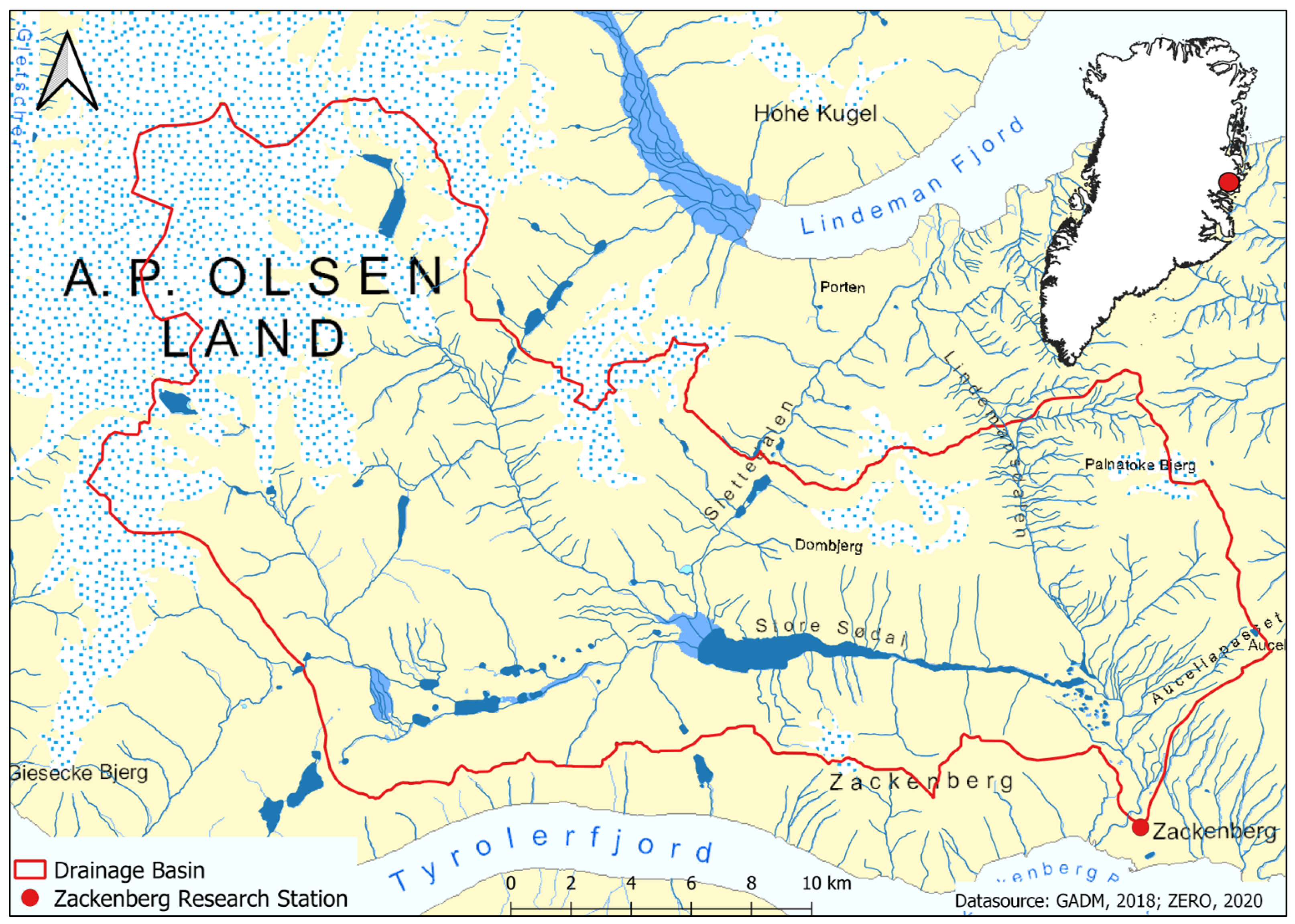
Figure 1. Location of Zackenberg Research Station and the drainage basin of Zackenberg River in Greenland, own representation based on data provided by GADM [30] and ZERO [31].
Climate 09 00059 g001
Figure 2. Walter climate diagram of Zackenberg based on climate data [40,41] between 1996–2019.
Climate 09 00059 g002
Figure 3. Hydrographs consisting of discharge measurements between 1996 and 2019. The date is displayed as the day of the month. Extreme discharge events are labelled with their estimated maximum peak discharge. Note the missing data after a flood in 2005.
Climate 09 00059 g003
Figure 4. Linear trends calculated for the different parameters with their corresponding R 2 values and p-values. (a) Annual discharge between 1996 and 2019, including the trend between 1996 and 2003 as found by Mernild et al. [27]. (b) Mean annual air temperature between 1996 and 2019. (c) Thawing Degree Days between 1996 and 2019. (d) Annual precipitation between 1996 and 2019.
Climate 09 00059 g004
Figure 5. Bars indicating the period of running water in Zackenberg River between 1996 and 2019. Start and end of the period, respectively river break-up and freeze-up, indicated by the day of the year.
Climate 09 00059 g005
Figure 6. Max. snow depth in comparison to the total discharge (1996–2019). The blue bars mark the max. snow depth measured during a year, while the black line shows the total discharge of Zackenberg River.
Climate 09 00059 g006
Table 1. Pearson’s correlation coefficient (r) testing for a linear relationship between the mentioned variables and the p-value testing for non-correlation. The significance level is α = 0.05 .
Discharge VariableClimatic Variablerp-Value
Discharge periodTDD0.52<0.01
Total annual dischargeMaximum snow depth0.480.02
Daily average dischargeDaily average air temperature−0.47<0.01
Total annual dischargeTDD0.250.24
Total annual dischargeMAAT0.220.29
Daily average dischargeDaily precipitation sum0.020.10
Total annual dischargeAnnual precipitation sum0.000.99
Publisher’s Note: MDPI stays neutral with regard to jurisdictional claims in published maps and institutional affiliations.