
Adaption to Climate Change through Fallow Rotation in the U.S. Pacific Northwest

Abstract
:1. Introduction
2. Fallow Response Estimation Strategy
2.1. Data
2.2. Estimation Equation
3. Results
3.1. Impacts of Climate Factors
3.2. Impacts of Non-Climate Variables
3.3. Robustness Checks
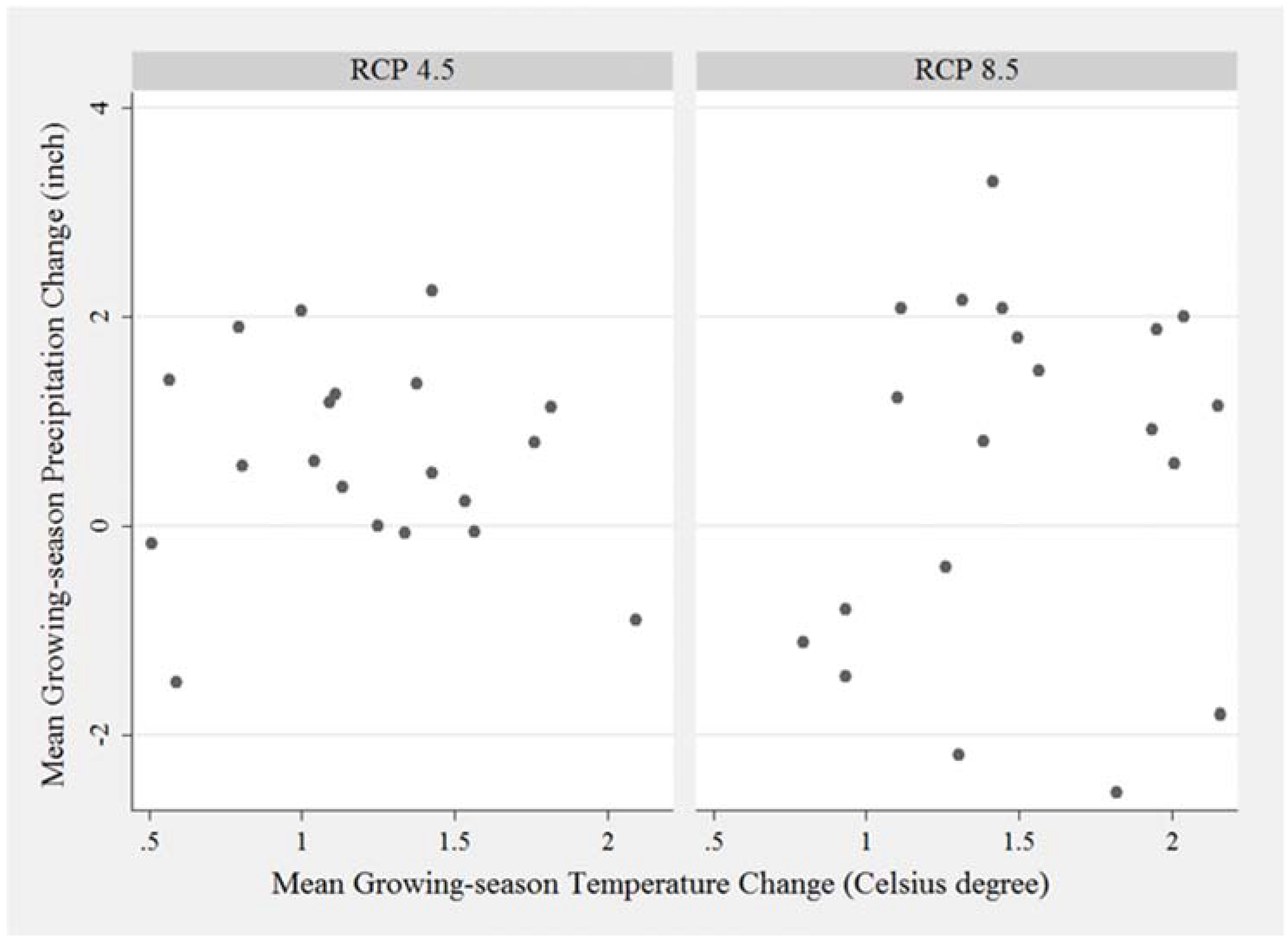
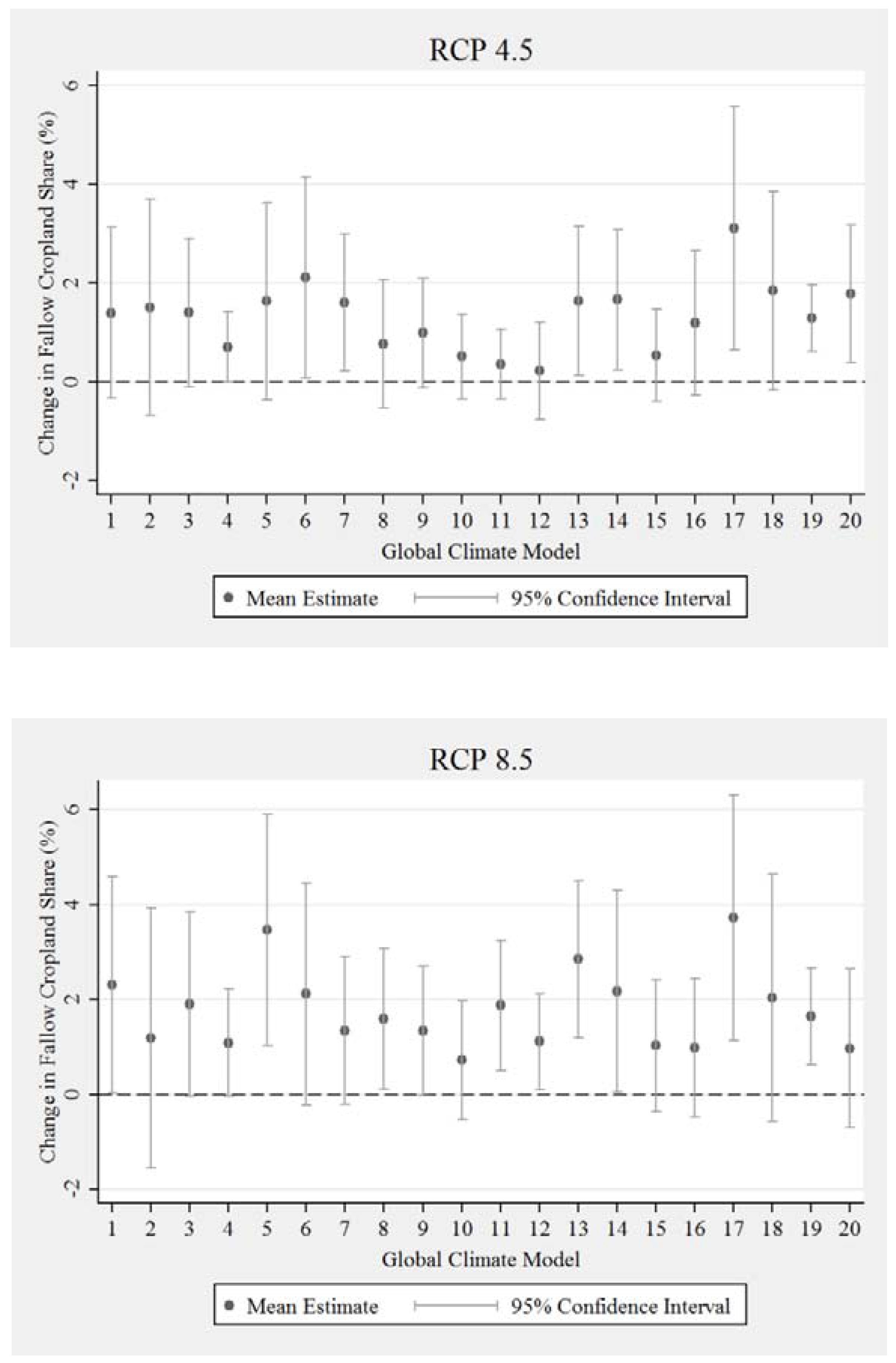
4. Cropland Fallow Implications of the Projected Future Climate
5. Conclusions
Acknowledgments
Author Contributions
Conflicts of Interest
Appendix A

| Variables | Simple Climate | Add Climate Squared | Add Climate Squared and Variability |
|---|---|---|---|
| Precipitation | −0.37*** | −1.40*** | −1.65*** |
| (0.07) | (0.20) | (0.23) | |
| Average temperature | 0.51** | −1.23 | −0.40 |
| (0.25) | (0.97) | (1.05) | |
| Precipitation square | 0.02*** | 0.01*** | |
| (0.00) | (0.00) | ||
| Average temperature square | 0.13 | 0.06 | |
| (0.08) | (0.09) | ||
| Std. dev. precipitation | 1.64*** | ||
| (0.63) | |||
| Std. dev. average temperature | 1.47 | ||
| (6.29) | |||
| Irrigation proportion | −0.19*** | −0.20*** | −0.20*** |
| (0.01) | (0.01) | (0.01) | |
| CRP and WRP programs | −2.82*** | −3.25*** | −3.43*** |
| (1.03) | (1.10) | (1.14) | |
| Classified as a large farm | −1.02*** | −1.21*** | −1.14*** |
| (0.34) | (0.33) | (0.32) | |
| Years of farming experience | 0.03** | 0.03*** | 0.03** |
| (0.01) | (0.01) | (0.01) | |
| Land tenure | −2.16*** | −2.19*** | −2.23*** |
| (0.38) | (0.37) | (0.37) | |
| Farming occupation | 0.93* | 0.94* | 0.92* |
| (0.49) | (0.49) | (0.49) | |
| Slope | −0.10 | −0.03 | 0.03 |
| (0.06) | (0.06) | (0.06) | |
| Soil organic content | −0.66*** | −0.43** | −0.37* |
| (0.21) | (0.21) | (0.21) | |
| Sand content | −0.44*** | −0.43*** | −0.37*** |
| (0.10) | (0.10) | (0.10) | |
| Silt content | −0.02 | 0.07 | 0.12 |
| (0.11) | (0.11) | (0.11) | |
| Clay content | −0.94*** | −0.91*** | −0.90*** |
| (0.17) | (0.16) | (0.16) | |
| Soil loss tolerance (T) factor | 2.10* | 1.75 | 1.23 |
| (1.17) | (1.14) | (1.16) | |
| Erodibility factor | −37.41*** | −43.18*** | −41.00*** |
| (11.70) | (11.26) | (11.18) | |
| Constant | 59.64*** | 72.79*** | 63.48*** |
| (7.70) | (8.17) | (9.95) | |
| State-year dummy variables | Yes | Yes | Yes |
| Observations | 17,773 | 17,773 | 17,773 |
| R-squared | 0.350 | 0.359 | 0.361 |
References
- Food and Agriculture Organization of the United Nations. FAOSTAT Statistics Database. Available online: http://www.fao.org/faostat/en/#data (accessed on 27 July 2017).
- Shiferaw, B.; Smale, M.; Braun, H.; Duveiller, E.; Reynolds, M.; Muricho, G. Crops that feed the world 10. Past success and future challenges to the role played by wheat in global food security. Food Secur. 2012, 5, 291–317. [Google Scholar] [CrossRef]
- IPCC. Climate Change 2014: Impacts, Adaptation, and Vulnerability. Part A: Global and Sectoral Aspects. Contribution of Working Group II to the Fifth Assessment Report of the Intergovernmental Panel on Climate Change; Field, C.B., Barros, V.R., Dokken, D.J., Mach, K.J., Mastrandrea, M.D., Bilir, T.E., Chatterjee, M., Ebi, K.L., Estrada, Y.O., Genova, R.C., et al., Eds.; Cambridge University Press: Cambridge, UK; New York, NY, USA, 2014. [Google Scholar]
- Annan, F.; Schlenker, W. Federal crop insurance and the disincentive to adapt to extreme heat. Am. Econ. Rev. Pap. Proc. 2015, 105, 262–266. [Google Scholar] [CrossRef]
- Antle, J.M.; Zhang, H.; Mu, J.; Abatzoglou, J.; Stockle, C. Methods to assess cropping system adaptations to climate change: Dryland wheat systems in the Pacific Northwest United States. Agric. Ecosyst. Environ. 2017, in press. [Google Scholar] [CrossRef]
- Ge, J.; Xu, Y.; Zhong, X.; Li, S.; Tian, S.; Yuan, G.; Cao, C.; Zhan, M.; Zhao, M. Climatic conditions varied by planting date affects maize yield in central China. Agron. J. 2016, 108, 966–977. [Google Scholar] [CrossRef]
- Huang, L.; Sun, Y.; Peng, S.; Wang, F. Genotypic differences of japonica rice responding to high temperature in China. Agron. J. 2016, 108, 626–636. [Google Scholar] [CrossRef]
- McCarl, B.A.; Thayer, A.; Jones, J.P.H. The challenge of climate change adaptation: An economically oriented review. J. Agric. Appl. Econ. 2016, 48, 321–344. [Google Scholar] [CrossRef]
- Mu, J.E.; Antle, J.M.; Abatzoglou, J.T. Climate Change, Weather events, Future Socio-economic Scenarios and Agricultural Land Use; Oregon State University: Corvallis, OR, USA, 2016. [Google Scholar]
- Negri, D.H.; Gollehon, N.R.; Aillery, M.P. The effects of climatic variability on US irrigation adoption. Clim. Chang. 2005, 69, 299–323. [Google Scholar] [CrossRef]
- Ortiz-Bobea, A.; Just, R.E. Modeling the structure of adaptation in climate change impact assessment. Am. J. Agric. Econ. 2013, 95, 244–251. [Google Scholar] [CrossRef]
- Olen, B.; Wu, J.; Langpap, C. Irrigation decisions for major west coast crops: Water scarcity and climatic determinants. Am. J. Agric. Econ. 2016, 98, 254–275. [Google Scholar] [CrossRef]
- Bradshaw, B.; Dolan, H.; Smit, B. Farm–level adaptation to climate variability and change: Crop diversification in the Canadian Prairies. Clim. Chang. 2004, 67, 119–141. [Google Scholar] [CrossRef]
- Howden, S.M.; Soussana, J.; Tubiello, F.N.; Chhetri, N.; Dunlop, M.; Meinke, H. Adapting agricultural to climate change. Proc. Natl. Acad. Sci. USA 2007, 104, 19691–19696. [Google Scholar] [CrossRef] [PubMed]
- Verchot, L.V.; Van Noordwijk, M.; Kandji, S.; Tomich, T.; Ong, C.; Albrecht, A.; Mackensen, J.; Bantilan, C.; Anupama, K.V.; Palm, C. Climate change: Linking adaptation and mitigation through agroforestry. Mitig. Adapt. Strateg. Glob. Chang. 2007, 12. [Google Scholar] [CrossRef]
- Crop Production 2016 Summary; United States Department of Agriculture: Erie, KS, USA, 2017.
- National Agricultural Statistics Service (USDA). Census of Agriculture; National Agricultural Statistics Service (USDA): Helena, MT, USA, 2002.
- Natural Resources Conservation Service (USDA). Gridded Soil Survey Geographic (gSSURGO) Database for the Conterminous United States. Available online: https://gdg.sc.egov.usda.gov/ (accessed on 16 November 2015).
- Abatzoglou, J.T. Development of gridded surface meteorological data for ecological applications and modelling. Int. J. Climatol. 2011. [Google Scholar] [CrossRef]
- Abatzoglou, J.T.; Brown, T.J. A comparison of statistical downscaling methods suited for wildfire applications. Int. J. Climatol. 2012, 32, 772–780. [Google Scholar] [CrossRef]
- Adams, R.M. Global Climate Change and Agriculture: An Economic Perspective. Am. J. Agric. Econ. 1989, 71, 1272–1279. [Google Scholar] [CrossRef]
- Mendelsohn, R.; Nordhaus, W.D.; Shaw, D. The impact of global warming on agriculture: A Ricardian analysis. Am. Econ. Rev. 1994, 84, 753–771. [Google Scholar]
- McCarl, B.A.; Villavicencio, X.; Wu, X.M. Climate change and future analysis: Is stationarity dying? Am. J. Agric. Econ. 2008, 90, 1242–1247. [Google Scholar] [CrossRef]
- Schlenker, W.; Roberts, M.J. Nonlinear temperature effects indicate severe damage to U.S. crop yields under climate change. Proc. Natl. Acad. Sci. USA 2009, 106, 15594–15598. [Google Scholar] [CrossRef] [PubMed]
- Mu, J.E.; McCarl, B.A.; Wein, A.M. Adaptation to climate change: Changes in farmland use and stocking rate in the U.S. Mitig. Adapt. Strateg. Glob. Chang. 2013, 18, 713–730. [Google Scholar] [CrossRef]
- Jiang, P.; Thelen, K.D. Effect of soil and topographic properties on crop yield in a North–Central corn–soybean cropping system. Agron. J. 2004, 96, 252–258. [Google Scholar] [CrossRef]
- Stewart, C.M.; McBratney, A.B.; Skerritt, J.H. Site–specific durum wheat quality and its relationship to soil properties in a single field in Northern New South Wales. Precis. Agric. 2002, 3, 155–168. [Google Scholar] [CrossRef]
- Deschenes, O.; Greenstone, M. The economic impacts of climate change: evidence from agricultural output and random fluctuations in weather. Am. Econ. Rev. 2007, 97, 354–385. [Google Scholar] [CrossRef]
- Flato, G.; Marotzke, J.; Abiodun, B.; Braconnot, P.; Chou, S.C.; Collins, W.; Cox, P.; Driouech, F.; Emori, S.; Eyring, V.; et al. Evaluation of climate models. In Climate Change 2007: The Physical Science Basis. Contribution of Working Group I to the Fourth Assessment Report of the Intergovernmental Panel on Climate Change; Stocker, T.F., Qin, D., Plattner, G.-K., Tignor, M., Allen, S.K., Boschung, J., Nauels, A., Xia, Y., Bex, V., Midgley, P.M., Eds.; Cambridge University Press: Cambridge, UK; New York, NY, USA, 2013; pp. 741–866. [Google Scholar]
- Mu, J.E.; Sleeter, B.; Abatzoglou, J.; Antle, J. Climate impacts on agricultural land use in the United States: the role of socio–economic scenarios. Clim. Chang. 2007. Available online: http://link.springer.com/article/10.1007/s10584-017-2033-x (accessed on 11 August 2017).
- Attavanich, W.; McCarl, B.A. How is CO2 affecting yields and technological progress? A statistical analysis. Clim. Chang. 2014, 124, 747–762. [Google Scholar] [CrossRef]

| All Farms | Farms That Did Not Fallow | Farms That Did Fallow | Variable Description | ||||
|---|---|---|---|---|---|---|---|
| Mean | Std. Dev. | Mean | Std. Dev. | Mean | Std. Dev. | ||
| Panel A | |||||||
| Fallow proportion | 11.20 | 17.87 | 0.00 | 0.00 | 29.53 | 17.34 | Share of fallowed cropland in percent |
| Irrigation proportion | 0.39 | 0.48 | 0.55 | 0.49 | 0.12 | 0.30 | Percent of irrigated wheat acreage |
| CRP and WRP programs | 0.06 | 0.21 | 0.04 | 0.22 | 0.09 | 0.18 | Share of cropland under CRP and WRP programs |
| Classified as a large farm | 0.61 | 0.49 | 0.61 | 0.49 | 0.60 | 0.49 | Annual farm revenue of over $250,000 (1 = yes, 0 = no) |
| Years of farming experience | 25.86 | 13.68 | 25.50 | 13.65 | 26.44 | 13.73 | Farming experience (years) |
| Land tenure | 0.82 | 0.38 | 0.85 | 0.36 | 0.78 | 0.41 | Farmland fully or partially owned by an operator (1 = yes, 0 = no) |
| Farming occupation | 0.90 | 0.30 | 0.89 | 0.31 | 0.91 | 0.29 | Operator occupation (1 = farming, 0 = employed off-farm) |
| Panel B | |||||||
| Slope | 14.00 | 8.62 | 12.63 | 8.79 | 16.23 | 7.84 | Average land slope in percent |
| Soil organic content | 7.88 | 4.41 | 7.90 | 4.79 | 7.85 | 3.69 | Soil organic matter in 1 meter depth (kg C/m2) |
| Sand content | 27.27 | 12.18 | 28.37 | 12.69 | 25.47 | 11.06 | Percent of particles with 0.05–2 mm in diameter |
| Silt content | 45.32 | 11.46 | 44.08 | 11.45 | 47.35 | 11.20 | Percent of particles with 0.002–0.05 mm in diameter |
| Clay content | 15.27 | 5.85 | 15.78 | 6.05 | 14.44 | 5.42 | Percent of particles with <0.002 mm in diameter |
| Soil loss tolerance (T) factor | 3.65 | 0.72 | 3.63 | 0.72 | 3.69 | 0.72 | Soil loss tolerance factor (tons/acre/year) |
| Erodibility factor | 0.37 | 0.09 | 0.36 | 0.09 | 0.37 | 0.09 | Soil erodibility factor (value range from 0.02–0.68) |
| Panel C | |||||||
| Precipitation | 16.22 | 9.75 | 16.75 | 11.05 | 15.35 | 7.05 | 22-year average of growing season total precipitation (inch) |
| Average temperature | 7.09 | 1.74 | 7.09 | 1.87 | 7.09 | 1.49 | 22-year average of growing season average temperature (°C) |
| Std. dev. precipitation | 3.61 | 2.11 | 3.83 | 2.38 | 3.24 | 1.49 | Standard deviation of growing season total precipitation (inch) |
| Std. dev. average temp. | 0.77 | 0.11 | 0.77 | 0.12 | 0.77 | 0.10 | Standard deviation of growing season average temperature (°C) |
| Maximum temperature | 13.16 | 1.54 | 13.27 | 1.64 | 12.99 | 1.36 | 22-year average of growing season maximum temperature (°C) |
| Std. dev. maximum temp. | 0.94 | 0.12 | 0.95 | 0.13 | 0.92 | 0.09 | Standard deviation of growing season maximum temperature (°C) |
| Growing degree-days | 23.82 | 3.79 | 23.92 | 4.04 | 23.65 | 3.34 | 22-year average of growing degree-days (100 degree-days) |
| Freezing degree-days | 2.38 | 1.67 | 2.50 | 1.84 | 2.20 | 1.34 | 22-year average of freezing degree-days (100 degree-days) |
| Std. dev. GDD | 1.52 | 0.15 | 1.52 | 0.17 | 1.52 | 0.13 | Standard deviation of growing degree-days (100 degree-days) |
| Std. dev. FDD | 1.12 | 0.47 | 1.13 | 0.52 | 1.10 | 0.37 | Standard deviation of freezing degree-days (100 degree-days) |
| Sample size | 17,773 | 11,033 | 6740 | ||||
| Variables | Simple Climate | Climate Squared | Climate Squared and Variability |
|---|---|---|---|
| Precipitation | −0.37*** | −0.88*** | −1.18*** |
| (0.07) | (0.11) | (0.17) | |
| Average temperature | 0.51** | 0.60** | 0.50 |
| (0.25) | (0.30) | (0.31) | |
| Std. dev. precipitation | 1.64*** | ||
| (0.63) | |||
| Std. dev. average temperature | 1.47 | ||
| (0.063) | |||
| Irrigation proportion | −0.19*** | −0.20*** | −0.20*** |
| (0.01) | (0.01) | (0.01) | |
| CRP and WRP programs | −2.82*** | −3.25*** | −3.43*** |
| (1.03) | (1.10) | (1.14) | |
| Classified as a large farm | −1.02*** | −1.21*** | −1.14*** |
| (0.34) | (0.33) | (0.32) | |
| Years of farming experience | 0.03** | 0.03*** | 0.03** |
| (0.01) | (0.01) | (0.01) | |
| Land tenure | −2.16*** | −2.19*** | −2.23*** |
| (0.38) | (0.37) | (0.37) | |
| Farming occupation | 0.93* | 0.94* | 0.92* |
| (0.49) | (0.49) | (0.49) | |
| Slope | −0.10 | −0.03 | 0.03 |
| (0.06) | (0.06) | (0.06) | |
| Soil organic content | −0.66*** | −0.43** | −0.37* |
| (0.21) | (0.21) | (0.21) | |
| Sand content | −0.44*** | −0.43*** | −0.37*** |
| (0.10) | (0.10) | (0.10) | |
| Silt content | -0.02 | 0.07 | 0.12 |
| (0.11) | (0.11) | (0.11) | |
| Clay content | −0.94*** | −0.91*** | −0.90*** |
| (0.17) | (0.16) | (0.16) | |
| Soil loss tolerance (T) factor | 2.10* | 1.75 | 1.23 |
| (1.17) | (1.14) | (1.16) | |
| Erodibility factor | −37.41*** | −43.18*** | −41.00*** |
| (11.70) | (11.26) | (11.18) | |
| Intercept | Yes | Yes | Yes |
| State-year dummy variables | Yes | Yes | Yes |
| R-squared | 0.350 | 0.359 | 0.361 |
| Observations | 17,773 | 17,773 | 17,773 |
| Variables | Using Maximum Temperature | Using Growing and Freezing Degree-days |
|---|---|---|
| Precipitation | −1.29*** | −1.08*** |
| (0.17) | (0.19) | |
| Std. dev. precipitation | 2.04*** | 1.38* |
| (0.61) | (0.71) | |
| Maximum temperature | 0.10 | |
| (0.33) | ||
| Std. dev. maximum temperature | −15.77*** | |
| (4.82) | ||
| Growing degree-days | 0.56* | |
| (0.31) | ||
| Freezing degree-days | 1.47 | |
| (1.60) | ||
| Std. dev. growing degree-days | −3.71 | |
| (3.66) | ||
| Std. dev. freezing degree-days | −2.14 | |
| (2.88) |
© 2017 by the authors. Licensee MDPI, Basel, Switzerland. This article is an open access article distributed under the terms and conditions of the Creative Commons Attribution (CC BY) license (http://creativecommons.org/licenses/by/4.0/).
Share and Cite
Zhang, H.; Mu, J.E.; McCarl, B.A. Adaption to Climate Change through Fallow Rotation in the U.S. Pacific Northwest. Climate 2017, 5, 64. https://doi.org/10.3390/cli5030064
Zhang H, Mu JE, McCarl BA. Adaption to Climate Change through Fallow Rotation in the U.S. Pacific Northwest. Climate. 2017; 5(3):64. https://doi.org/10.3390/cli5030064
Chicago/Turabian StyleZhang, Hongliang, Jianhong E. Mu, and Bruce A. McCarl. 2017. "Adaption to Climate Change through Fallow Rotation in the U.S. Pacific Northwest" Climate 5, no. 3: 64. https://doi.org/10.3390/cli5030064
APA StyleZhang, H., Mu, J. E., & McCarl, B. A. (2017). Adaption to Climate Change through Fallow Rotation in the U.S. Pacific Northwest. Climate, 5(3), 64. https://doi.org/10.3390/cli5030064