
Identifying the Areas at Risk of Huaico Occurrences in the Department of Lima, Peru


Abstract
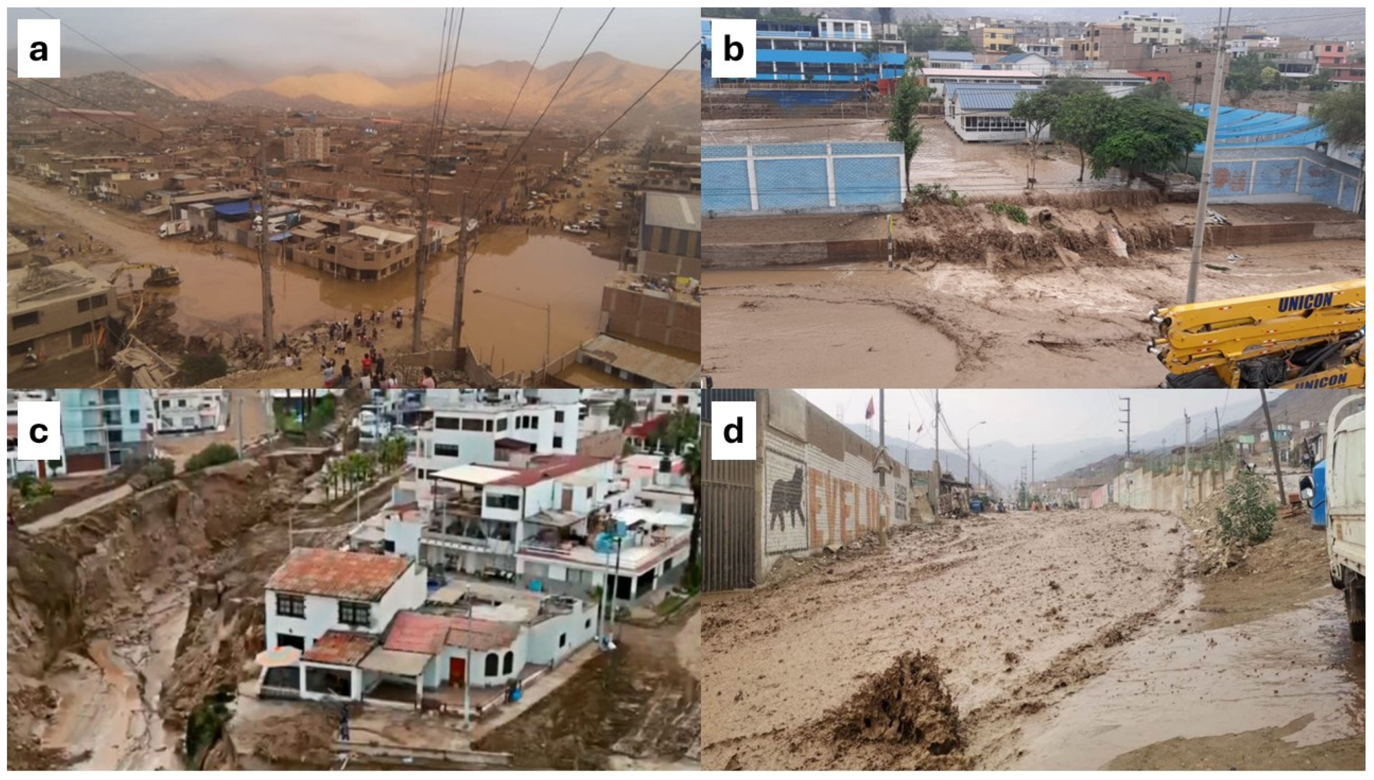
1. Introduction
2. Materials and Methods
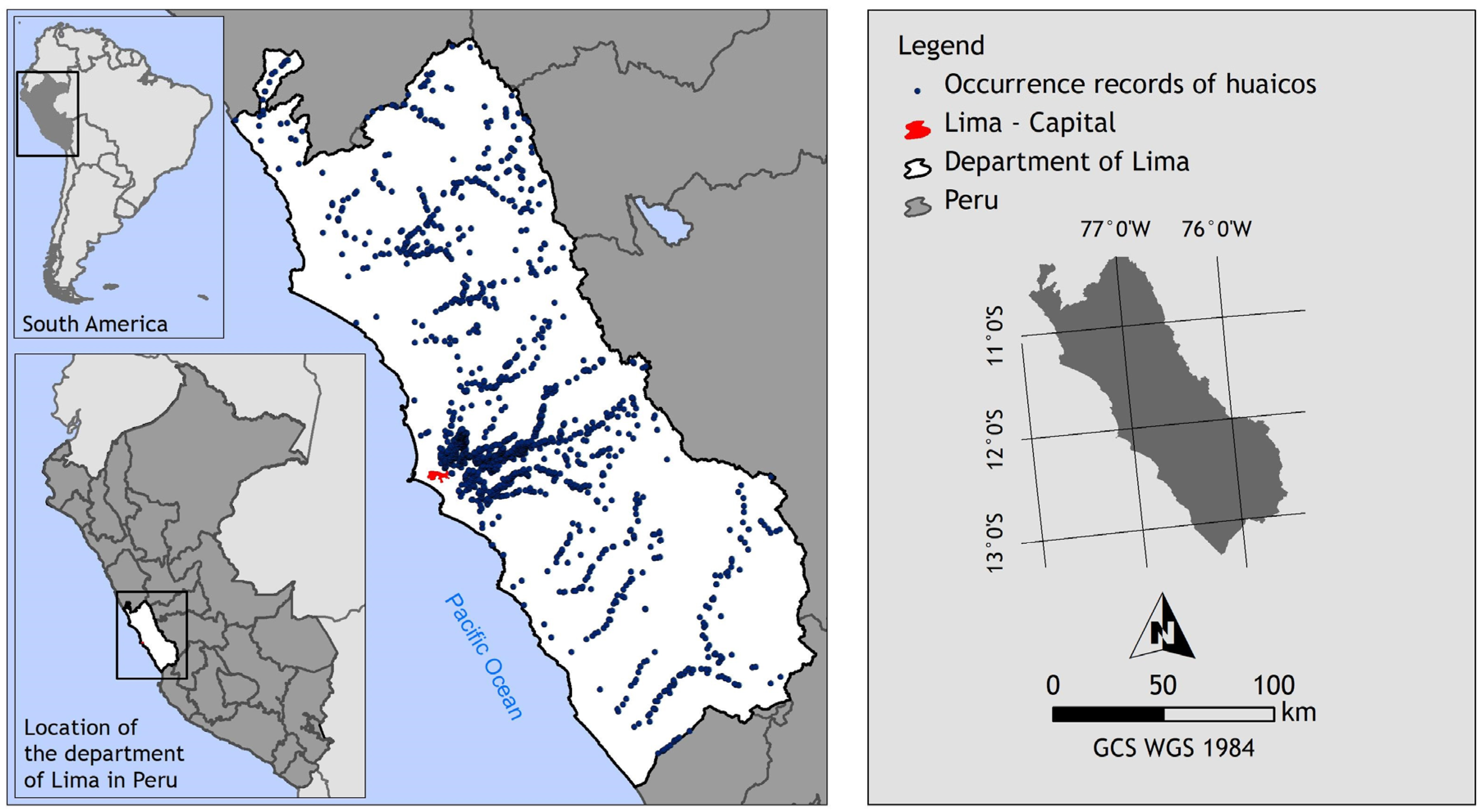
2.1. Study Area
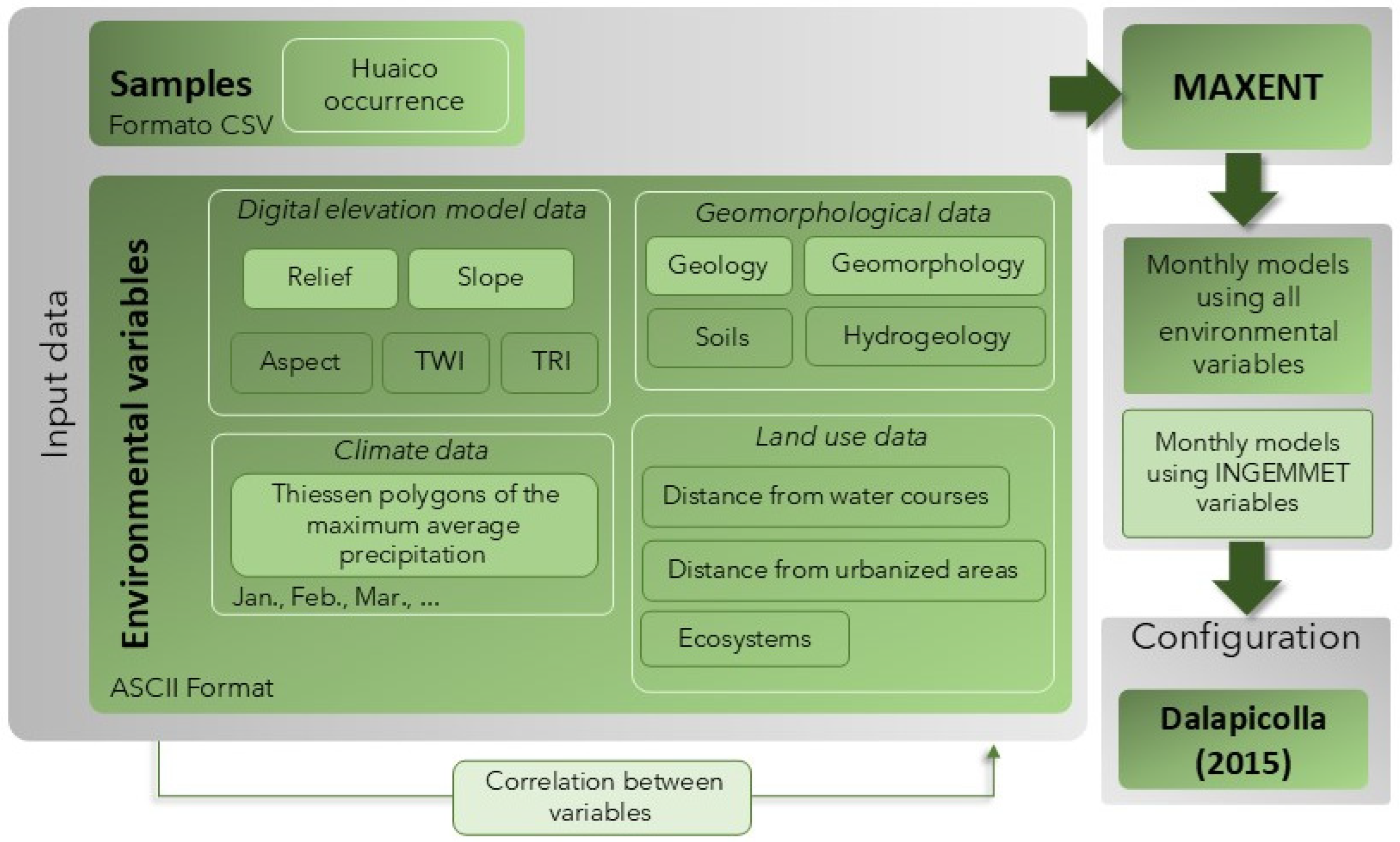
2.2. Input Data for the Algorithm
2.2.1. Data from the Inventory of Geological Hazards in Peru
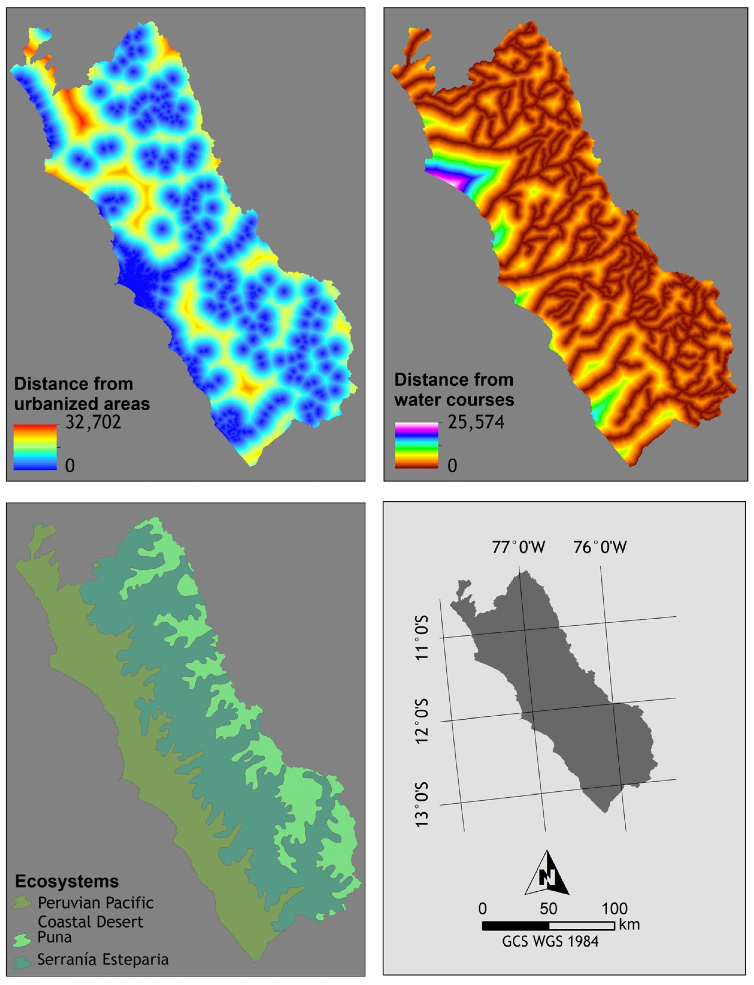
2.2.2. Environmental Variables
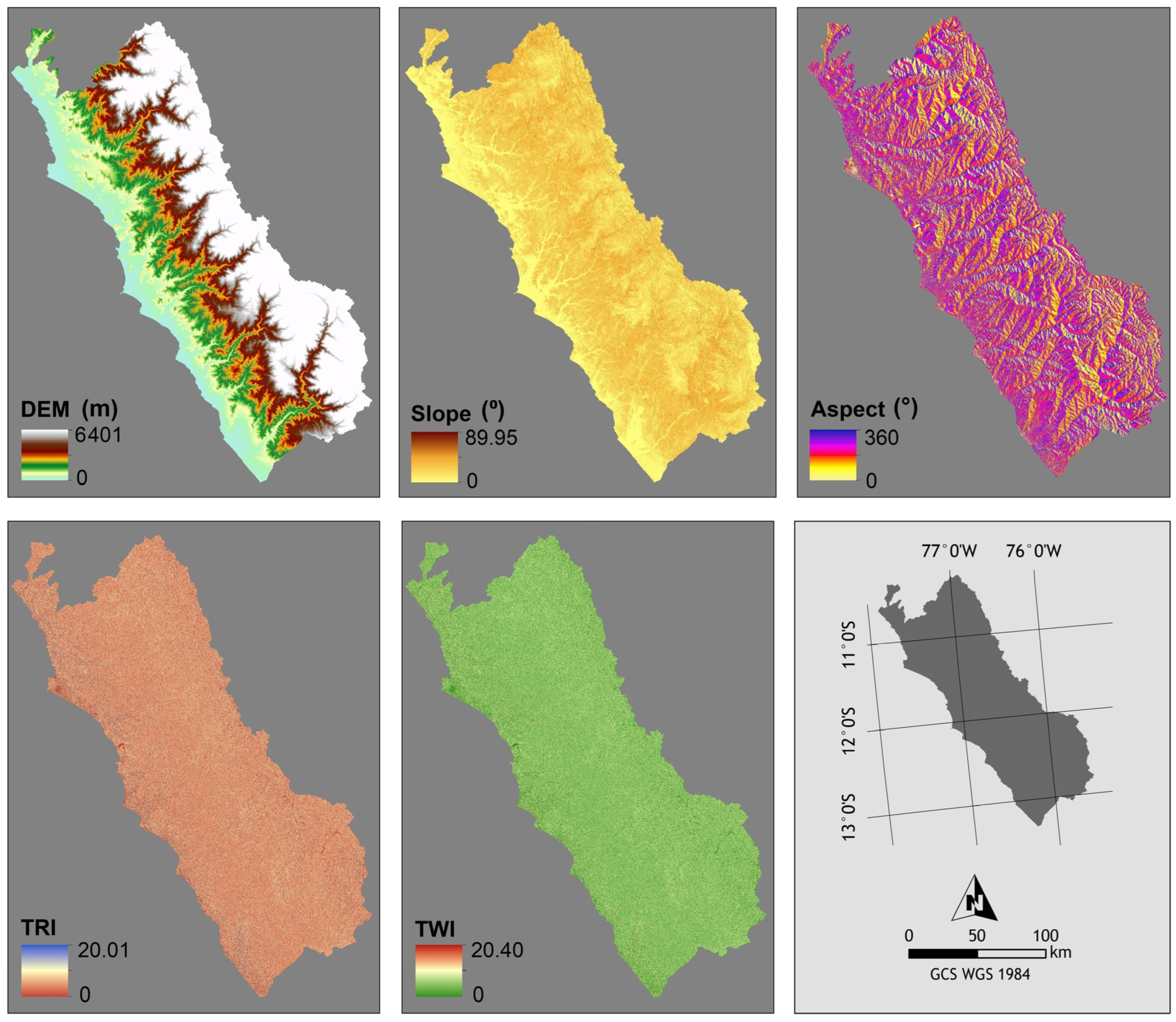
Digital Elevation Model
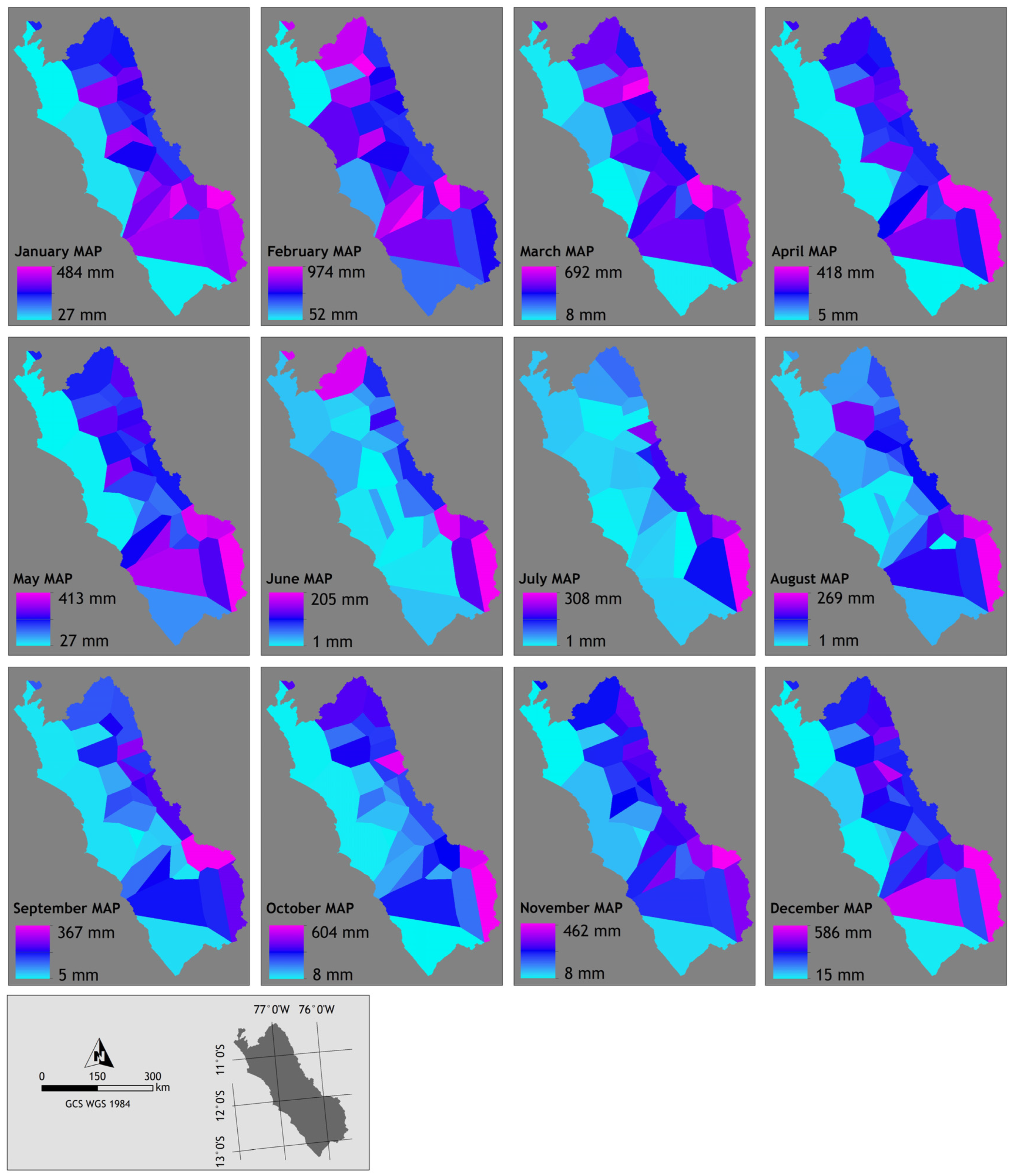
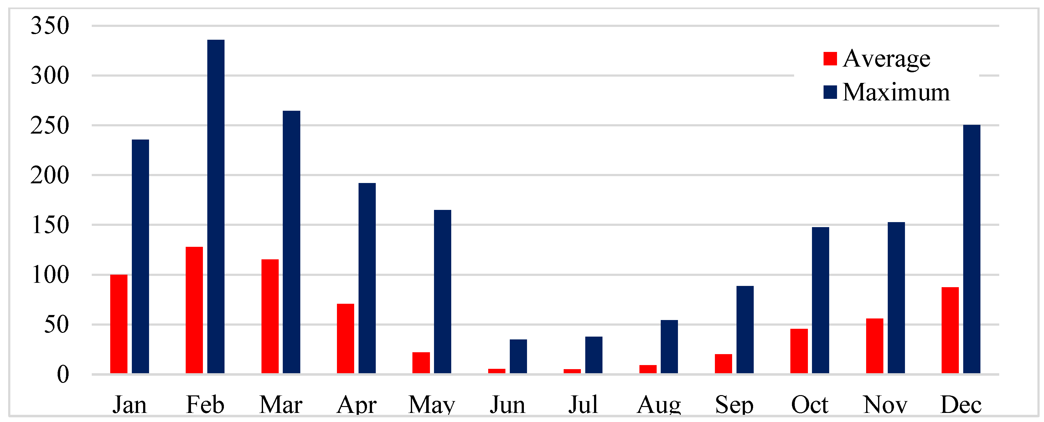
Climate Data
Geomorphological Data
Land Use Data
2.3. Maxent
3. Results and Discussion
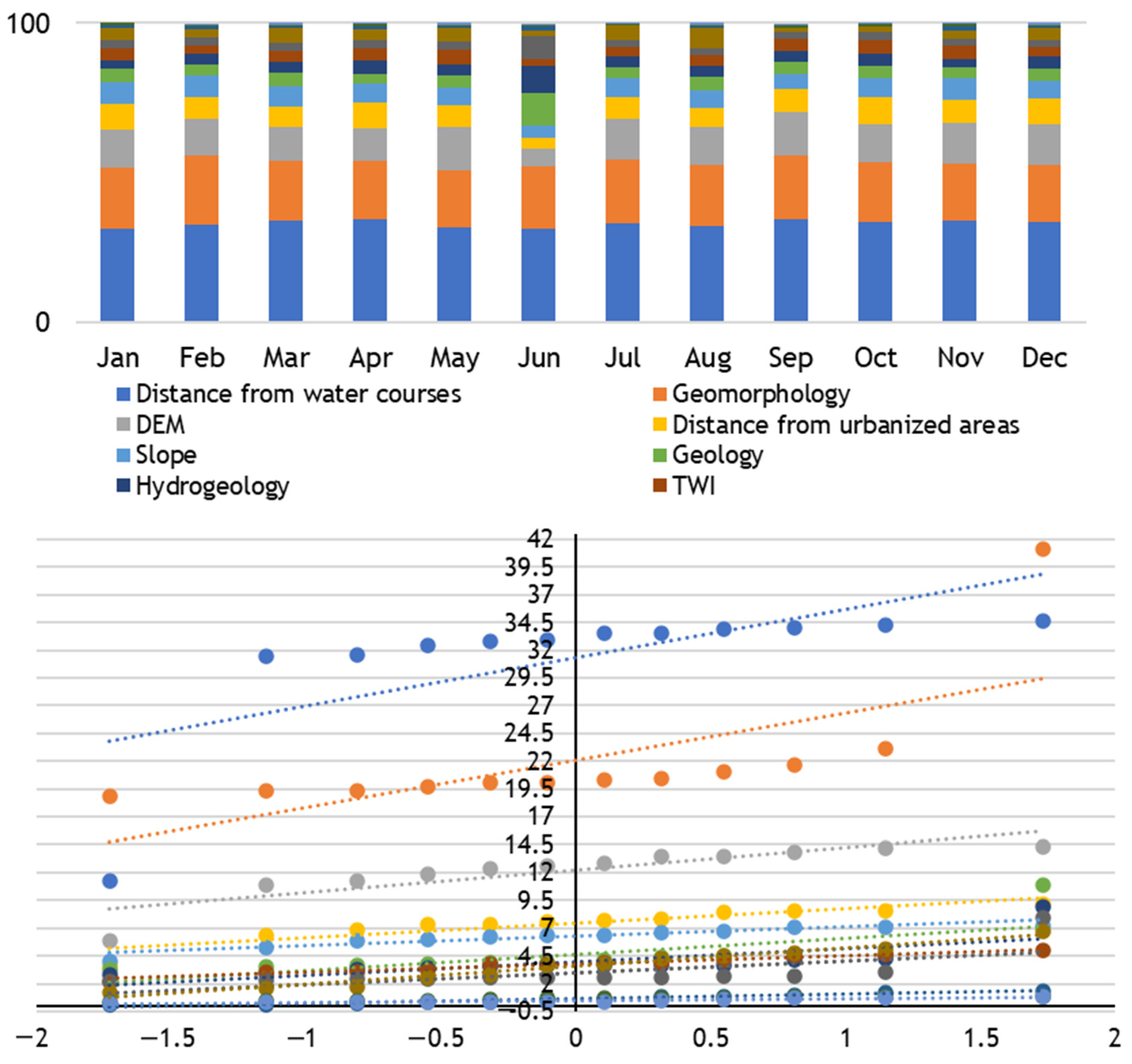
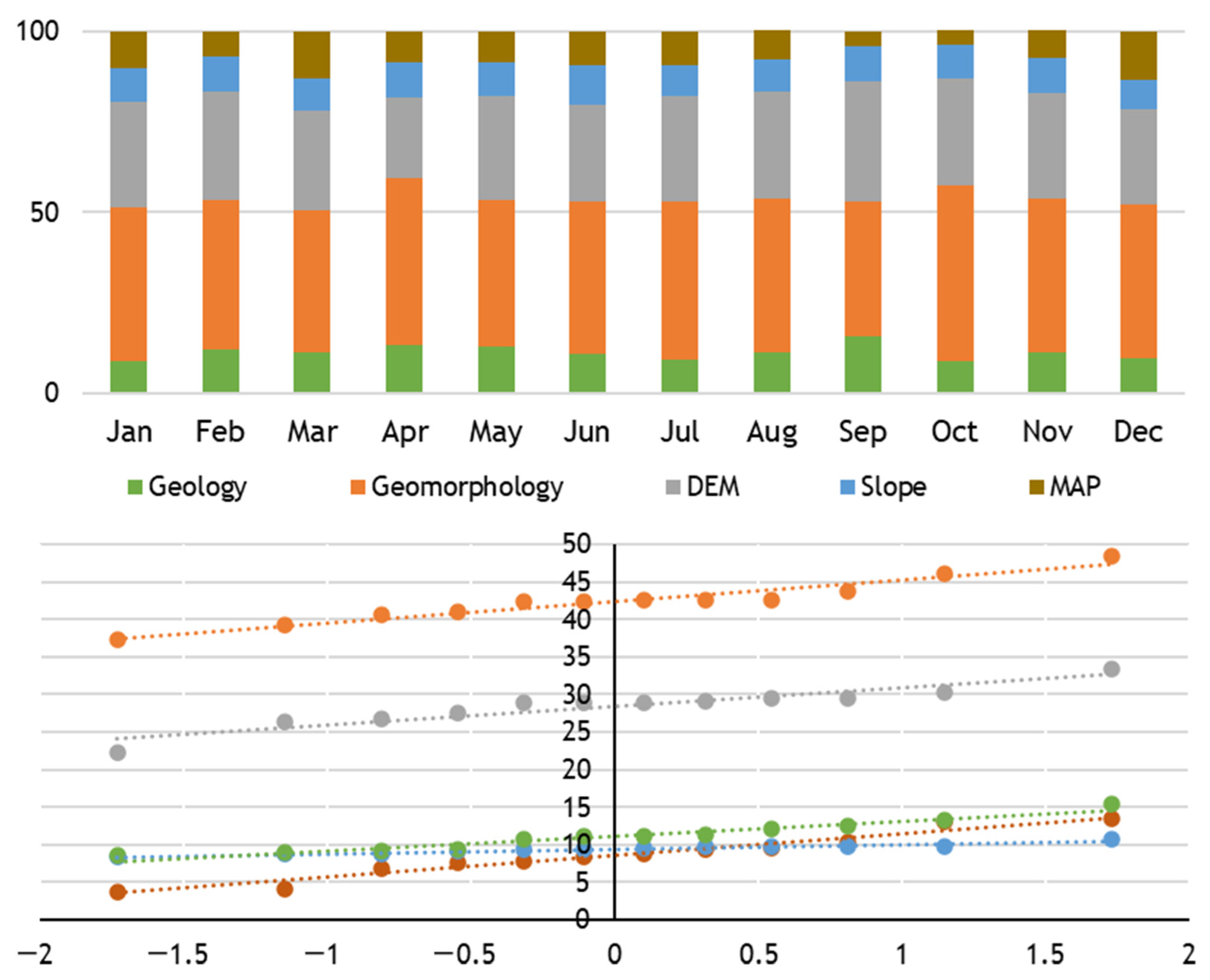
3.1. Environmental Variables
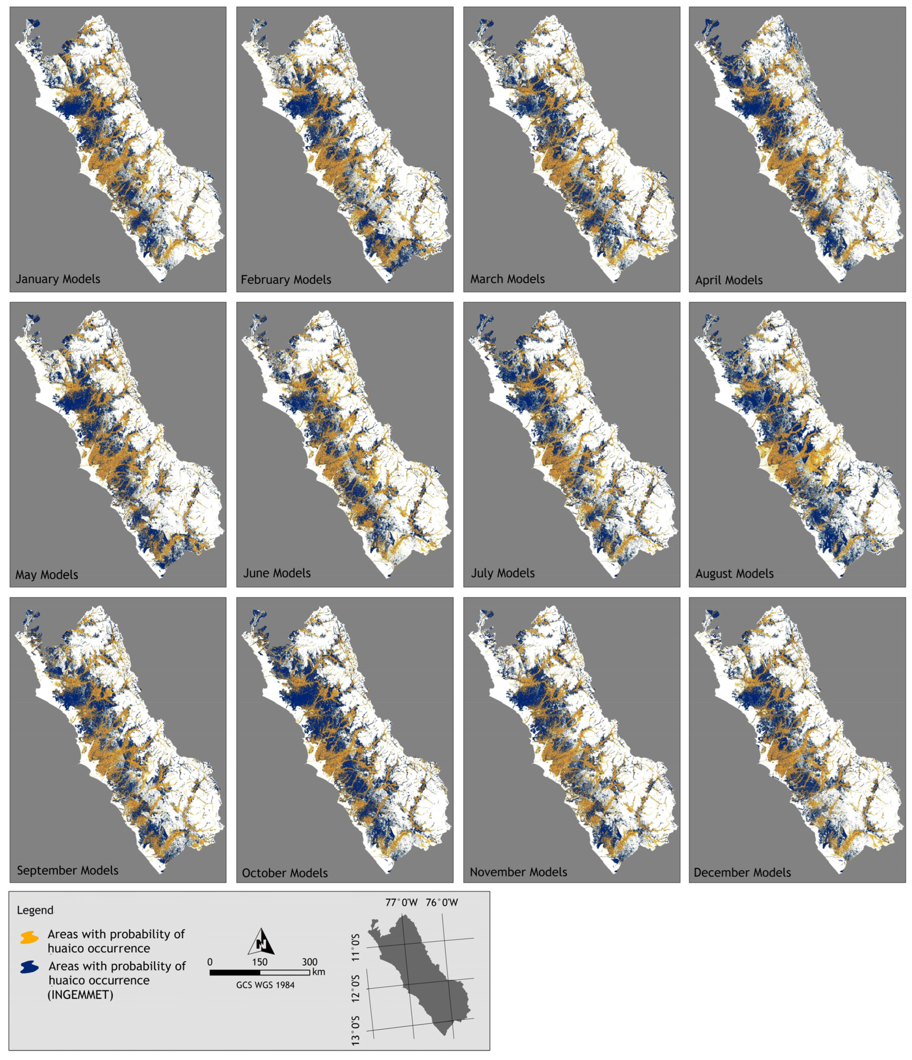
3.2. Modeling in Maxent
3.3. Uncertainty
4. Conclusions
Author Contributions
Funding
Data Availability Statement
Conflicts of Interest
References
- Moncayo, O.P. Rasgos Generales Sobre la Geología del Peru; INGEMMET: Lima, Peru, 1998.
- Instituto Geológico, Minero y Metalúrgico—INGEMMET. Estudio de Los Recursos Minerales del Perú; Franja n° 4: Lima, Peru, 2005. [Google Scholar]
- Medina, L.; Villacorta, S.; Zavala, B.; Vílchez, M.; Núñez, S.; Luque, G.; Calderón, E. Caracterización geomorfológica del Norte peruano. In Boletín de la Sociedad Geológica del Perú; INGEMMET: Lima, Peru, 2015; Volume 110, pp. 205–208. [Google Scholar]
- Ministerio del Ambiente del Gobierno del Perú—MINAM. Mapa Nacional de Ecosistemas del Perú; Memoria: Louisville, KY, USA, 2019. [Google Scholar]
- Rivera, M.; Vilchez, M.; Vela, J. Peligros por huaicos en la ciudad de Arequipa. In Fortalecimiento de Capacidades Para Mitigar Los Impactos de Huaicos en Perú; Porras, M.R., Phillips, J.C., Armijos Burneo, M.T., Contreras, R.A., Eds.; INGEMMET: Lima, Peru, 2018; pp. 45–49. [Google Scholar]
- Perú. Plan Nacional de Gestión del Riesgo de Desastres (PLANAGERD) 2022–2030; Instituto Nacional de Defensa Civil—INDECI: Lima, Peru, 2022.
- French, A.; Mechler, R.; Arestegui, M.; Macclune, K.; Cisneros, A. Root causes of recurrent catastrophe: The political ecology of El Niño-related disasters in Peru. Int. J. Disaster Risk Reduct. 2020, 47, 101539. [Google Scholar] [CrossRef]
- Instituto Nacional de Defensa Civil—INDECI. Compendio Estadístico del Instituto Nacional de Defensa Civil; INDECI: Lima, Peru, 2021.
- Instituto Nacional de Defensa Civil—INDECI. Compendio Estadístico del Instituto Nacional de Defensa Civil; INDECI: Lima, Peru, 2019.
- Federación de Periodistas del Perú. Lluvias y Huaicos: Al Menos 13 Distritos de Lima Sufren de Inundaciones. Available online: https://fpp.org.pe/__trashed-91/ (accessed on 10 December 2024).
- Diario La Otra Cara. Lima Este Inundada por los Huaicos y las Intensas Lluvias. Available online: https://diariolaotracara.com/lima-este-inundada-por-los-huaicos-y-las-intensas-lluvias/ (accessed on 10 December 2024).
- Willax. Huaicos en Lima: Alcalde de Punta de Hermosa Señala que “No hay Presupuesto” para Evitar el Colapso de Casa de Playa. Available online: https://willax.pe/actualidad/huaicos-en-lima-alcalde-de-punta-de-hermosa-senala-que-no-hay-presupuesto-para-evitar-el-colapso-de-casa-de-playa#google_vignette (accessed on 10 December 2024).
- CanalB pe. Lima Fueron los Más Golpeados Nuevamente por Huaicos. Available online: https://canalb.pe/noticias/actualidad/distritos-del-este-y-el-sur-de-lima-fueron-los-mas-golpeados-nuevamente-por-huaicos (accessed on 10 December 2024).
- United Nations—UN. Sendai Framework for Disaster Risk Reduction 2015–2030; United Nations Office for Disaster Risk Reduction: Geneva, Switzerland, 2015. [Google Scholar]
- Tehrani, F.S.; Calvello, M.; Liu, Z.; Zhang, L.; Lacasse, S. Machine learning and landslide studies: Recent advances and applications. Nat. Hazards 2022, 114, 1197–1245. [Google Scholar] [CrossRef]
- Ado, M.; Amitab, K.; Maji, A.K.; Jasińska, E.; Gono, R.; Leonowicz, Z.; Jasiński, M. Landslide susceptibility mapping using machine learning: A literature survey. Remote Sens. 2022, 14, 3029. [Google Scholar] [CrossRef]
- Bao, H.; Zeng, C.; Peng, Y.; Wu, S. The use of digital technologies for landslide disaster risk research and disaster risk management: Progress and prospects. Environ. Earth Sci. 2022, 81, 446. [Google Scholar] [CrossRef]
- Mosavi, A.; Ozturk, P.; Chau, K. Flood prediction using machine learning models: Review. Water 2018, 10, 1536. [Google Scholar] [CrossRef]
- Li, J.; Fang, Z.; Zhang, J.; Huang, O.; He, C. Mapping basin-scale supply-demand dynamics of flood regulation service—A case study in the Baiyangdian Lake Basin, China. Ecol. Indic. 2022, 139, 108902. [Google Scholar] [CrossRef]
- Bot, K.; Borges, J.G. A systematic review of applications of machine learning techniques for wildfire management decision support. Inventions 2022, 7, 15. [Google Scholar] [CrossRef]
- Alkhatib, R.; Sahwan, W.; Alkhatieb, A.; Schütt, B. A brief review of machine learning algorithms in forest fire science. Appl. Sci. 2023, 13, 8275. [Google Scholar] [CrossRef]
- Ridzwan, N.S.M.; Yusoff, S.H.M. Machine learning for earthquake prediction: A review (2017–2021). Earth Sci. Inform. 2023, 16, 1133–1149. [Google Scholar] [CrossRef]
- Ferreira, I.J.M.; Campanharo, W.A.; Barbosa, M.L.F.; da Silva, S.S.; Selaya, G.; Aragão, L.E.O.C.; Anderson, L.O. Assessment of fire hazard in Southwestern Amazon. Front. For. Glob. Change 2023, 6, 1107417. [Google Scholar] [CrossRef]
- Izquierdo- Horna, L.; Zevallos, J.; Yepez, Y. An integrated approach to seismic risk assessment using random forest and hierarchical analysis: Pisco, Peru. Heliyon 2022, 8, e10926. [Google Scholar] [CrossRef]
- Kumar, C.; Walton, G.; Santi, P.; Luza, C. An Ensemble Approach of Feature Selection and Machine Learning Models for Regional Landslide Susceptibility Mapping in the Arid Mountainous Terrain of Southern Peru. Remote Sens. 2023, 15, 1376. [Google Scholar] [CrossRef]
- Phillips, S.J.; Anderson, R.P.; Dudík, M.; Schapire, R.E.; Blair, M. Opening the black box: An open-source release of Maxent. Ecography 2017, 40, 887–893. [Google Scholar] [CrossRef]
- Javidan, N.; Kavian, A.; Pourghasemi, H.R.; Conoscenti, C.; Jafarian, Z.; Rodrigo-Comino, J. Evaluation of multi-hazard map produced using MaxEnt machine learning technique. Sci. Rep. 2021, 11, 6496. [Google Scholar] [CrossRef] [PubMed]
- Rusk, J.; Maharjan, A.; Tiwari, P.; Chen, T.H.K.; Shneiderman, S.; Turin, M.; Seto, K.C. Multi-hazard susceptibility and exposure assessment of the Hindu Kush Himalaya. Sci. Total Environ. 2022, 804, 150039. [Google Scholar] [CrossRef]
- Kornejady, A.; Ownegh, M.; Bahreman, A. Landslide susceptibility assessment uses a maximum entropy model with two data sampling methods. Catena 2017, 152, 144–162. [Google Scholar] [CrossRef]
- Chen, W.; Pourghasemi, H.R.; Kornejady, A.; Zhang, N. Landslide spatial modeling: Introducing new ensembles of ANN, MaxEnt, and SVM machine learning techniques. Geoderma 2017, 305, 314–327. [Google Scholar] [CrossRef]
- Mokhtari, M.; Abedian, S. Spatial prediction of landslide susceptibility in Taleghan basin, Iran. Stoch. Environ. Res. Risk Assess. 2019, 33, 1297–1325. [Google Scholar] [CrossRef]
- Sheikh, V.; Kornejady, A.; Ownegh, M. Application of the coupled TOPSIS–Mahalanobis distance for multi-hazard-based management of the target districts of the Golestan Province, Iran. Nat. Hazards 2019, 96, 1335–1365. [Google Scholar] [CrossRef]
- Yusri, S.; Retnowati, E.; Prastowo, M. Combining Participatory Mapping, Cloud Computing and Machine Learning for Mapping Climate Induced Landslide Susceptibility in Lembeh Island, North Sulawesi. In IOP Conference Series; Earth and Environmental Science: New York, NY, USA, 2019; Volume 363. [Google Scholar] [CrossRef]
- Innocenti, C.; Battaglini, L.; D’Angelo, S.; Fiorentino, A. Submarine landslides: Mapping the susceptibility in European seas. Q. J. Eng. Geol. Hydrogeol. 2020, 54, qjegh2020–qjegh2027. [Google Scholar] [CrossRef]
- Kim, H.G.; Park, C.Y. Landslide susceptibility analysis of photovoltaic power stations in Gangwon-do, Republic of Korea. Geomat. Nat. Hazards Risk 2021, 12, 2328–2351. [Google Scholar] [CrossRef]
- Liu, Y.; Xu, P.; Cao, C.; Shan, B.; Zhu, K.; Ma, Q.; Zhang, Z.; Yin, H. A comparative evaluation of machine learning algorithms and an improved optimal model for landslide susceptibility: A case study. Geomat. Nat. Hazards Risk 2021, 12, 1973–2001. [Google Scholar] [CrossRef]
- Liu, Y.; Zhao, L.; Bao, A.; Li, J.; Yan, X. Chinese high-resolution satellite data and gis -based assessment of landslide susceptibility along Highway G30 in Guozigou Valley using logistic regression and maxent model. Remote Sens. 2022, 14, 3620. [Google Scholar] [CrossRef]
- Shahzad, N.; Ding, X.; Abbas, S. A comparative assessment of machine learning models for landslide susceptibility mapping in the rugged terrain of northern pakistan. Appl. Sci. 2022, 12, 2280. [Google Scholar] [CrossRef]
- Pourghasemi, H.R.; Yousefi, S.; Kornejady, A.; Cerdà, A. Performance assessment of individual and ensemble data-mining techniques for gully erosion modeling. Sci. Total Environ. 2017, 609, 764–775. [Google Scholar] [CrossRef] [PubMed]
- Botero-Acosta, A.; Chu, M.L.; Guzman, J.A.; Starks, P.J.; Moriasi, D.N. Riparian erosion vulnerability model based on environmental characteristics. J. Environ. Manag. 2017, 203, 592–602. [Google Scholar] [CrossRef] [PubMed]
- Arabameri, A.; Asadi Nalivan, O.; Saha, S.; Roy, J.; Pradhan, B.; Tiefenbacher, J.P.; Thi Ngo, P.T. Novel ensemble approaches of machine learning techniques in modeling the gully erosion susceptibility. Remote Sens. 2020, 12, 1890. [Google Scholar] [CrossRef]
- Bosino, A.; Giordani, P.; Quénéhervé, G.; Maerker, M. Assessment of calanchi and rill –interrill erosion susceptibilities using terrain analysis and geostochastics: A case study in the Oltrepo Pavese, Northern Apennines, Italy. Earth Surf. Process. Landf. 2020, 45, 3025–3041. [Google Scholar] [CrossRef]
- Vacchiano, G.; Foderi, C.; Berretti, R.; Marchi, E.; Motta, R. Modeling anthropogenic and natural fire ignitions in an inner-alpine valley. Nat. Hazards Earth Syst. Sci. 2018, 18, 935–948. [Google Scholar] [CrossRef]
- Adab, H.; Atabati, A.; Oliveira, S.; Gheshlagh, A.M. Assessing fire hazard potential and its main drivers in Mazandaran province, Iran: A data-driven approach. Environ. Monit. Assess. 2018, 190, 670. [Google Scholar] [CrossRef] [PubMed]
- Martín, Y.; Zúñiga-Antón, M.; Mimbrero, M.R. Modeling temporal variation of fire occurrence towards the dynamic prediction of human wildfire ignition danger in northeast Spain. Geomat. Nat. Hazards Risk 2018, 10, 385–411. [Google Scholar] [CrossRef]
- Lim, C.H.; Kim, Y.S.; Won, M.; Kim, S.J.; Lee, W.K. Can satellite-based data substitute for surveyed data to predict the spatial probability of forest fire? A geostatistical approach to forest fire in the Republic of Korea. Geomat. Nat. Hazards Risk 2019, 10, 719–739. [Google Scholar] [CrossRef]
- Darabi, H.; Choubin, B.; Rahmati, O.; Haghighi, A.T.; Pradhan, B.; Kløve, B. Urban flood risk mapping using the GARP and QUEST models: A comparative study of machine learning techniques. J. Hydrol. 2019, 569, 142–154. [Google Scholar] [CrossRef]
- Norallahi, M.; Kaboli, H.S. Urban flood hazard mapping using machine learning models: GARP, RF, MaxEnt, and NB. Nat. Hazards 2021, 106, 119–137. [Google Scholar] [CrossRef]
- Rajabi, A.; Shabanlou, S.; Yosefvand, F.; Kiani, A. Exploring the sample size and replication scenarios effect on spatial prediction of flood, using MARS and MaxEnt methods case study: Saliantape catchment, Golestan, Iran. Nat. Hazards 2021, 109, 871–901. [Google Scholar] [CrossRef]
- Instituto Geológico, Minero y Metalúrgico—INGEMMET. Mapa de Inventario de Peligros Geológicos; INGEMMET: Lima, Peru, 2019.
- Peel, M.C.; Finlayson, B.L.; McMahon, T.A. Updated world map of the Köppen-Geiger climate classification. Hydrol. Earth Syst. Sci. 2007, 11, 1633–1644. [Google Scholar] [CrossRef]
- Servicio Nacional de Meteorología e Hidrología del Perú—SENAMHI. Mapa Climático del Perú. Available online: https://www.senamhi.gob.pe/?p=mapa-climatico-del-peru (accessed on 15 December 2024).
- Instituto Geológico, Minero y Metalúrgico—INGEMMET. Zonas Críticas Por Peligros Geológicos en la Cuenca Hancay-Lambayeque; INGEMMET: Lima, Peru, 2005.
- Instituto Geológico, Minero y Metalúrgico—INGEMMET. Peligros Por Movimientos en Masa en la Quebrada Tinaja (Dist. Pachacamac-Cieneguilla, Provincia y Región Lima); INGEMMET: Lima, Peru, 2012.
- Instituto Geológico, Minero y Metalúrgico—INGEMMET. Evaluación de Peligros Geológicos Por Movimientos en Masa en el Anexo de Colpa; INGEMMET: Lima, Peru, 2019.
- Instituto Geológico, Minero y Metalúrgico—INGEMMET. Inspección Geológica Realizada en la Quebrada San Lázaro—Arequipa; INGEMMET: Lima, Peru, 2020.
- Instituto Geológico, Minero y Metalúrgico—INGEMMET. Evaluación de Peligros Geológicos Por Flujo de Detritos (Huaicos) en la Quebrada Zaparo; INGEMMET: Lima, Peru, 2021.
- Instituto Geológico, Minero y Metalúrgico—INGEMMET. Carta Geológica Nacional a Escala 1:50000; INGEMMET: Lima, Peru, 2022.
- Instituto Geológico, Minero y Metalúrgico—INGEMMET. Mapa Geomorfológico del Perú; INGEMMET: Lima, Peru, 2016.
- Ministerio del Ambiente del Gobierno del Perú—MINAM. Mapa Nacional de Suelos del Perú; INGEMMET: Lima, Peru, 2009.
- Dalapicolla, J. Tutorial de Modelos de Distribuição de Espécies: Guia Prático Usando o Maxent e o Arcgis 10. In Laboratório de Mastozoologia e Biogeografia; Universidade Federal do Espírito Santo: Vitória, Brazil, 2016. [Google Scholar]
- Servicio Nacional de Meteorología e Hidrología del Perú—SENAMHI. Ministerio del Ambiente El Niño: Histórico de lluvias; Lima, Peru. 2021. Available online: https://www.senamhi.gob.pe/?&p=escenarios-lluvia (accessed on 17 September 2024).
- Gonzales, E.; Ingol, E. Determination of a New Coastal ENSO Oceanic Index for Northern Peru. Climate 2021, 9, 71. [Google Scholar] [CrossRef]
- Yesilnacar, E.K. The Application of Computational Intelligence to Landslide Susceptibility Mapping in Turkey. Ph.D Thesis, Department of Geomatics, University of Melbourne, Parkville, VIC, Australia, 2005; p. 423. [Google Scholar]
- Monserud, R.A.; Leemans, R. Comparing global vegetation maps with the Kappa statistic. Ecol. Model. 1992, 62, 275–293. [Google Scholar] [CrossRef]
- Instituto Geológico, Minero y Metalúrgico—INGEMMET. Evaluación de Peligros Geológicos en el Sector de Octuyoj-Manás; INGEMMET: Lima, Peru, 2021.
- Giráldez, L.; Silva, Y.; Flores-Rojas, J.L.; Trasmonte, G. Diagnosis of the Extreme Climate Events of Temperature and Precipitation in Metropolitan Lima during 1965–2013. Climate 2022, 10, 112. [Google Scholar] [CrossRef]


| Hazard Type | Study Area | Most Used Variables |
|---|---|---|
| Landslides [27,28,29,30,31,32,33,34,35,36,37,38]. | Iran (Gorganrood Watershed), Hindu Kush Himalaya, Iran (Ziarat watershed), China (Wanyuan), Iran (Taleghan Basin), Iran (Golestan Province), North Sulawesi (Lembeh Island), European Seas, Republic of Korea (Gangwon-do), China (Xulong Gully), China (Guozigou Valley), North Pakistan | Altitude, aspect, slope, distance from permanent watercourses, road distance, geology, curvature profile, curvature plane, precipitation, land use, topographic wetness index (TWI), and terrain ruggedness index (TRI) |
| Erosion [32,39,40,41,42]. | Iran (Golestan am Basin), Iran (Fars Province), United States (Fort Cobb watershed),Italy (Oltrepo Pavese) | Altitude, height above nearest drainage, aspect, slope, distance from roads, permanent watercourses, geology, precipitation, temperature, and land use |
| Fires [28,43,44,45,46]. | Hindu Kush Himalaya, Italy (Aosta Valley), Iran (Mazandaran Province), Northeast Spain, South Korea | Altitude, aspect, slope, precipitation (average, minimum), temperature (average, maximum), land use, and wind |
| Floods [27,28,32,47,48,49]. | Iran (Gorganrood Watershed), Hindu Kush Himalaya, Iran (Kermanshah City), Iran (Sari City), Iran (Golestan Province), Iran (Saliantapeh Catchment) | Altitude, aspect, slope, CN (curve number), distance from permanent watercourses, precipitation, and land use |
| Month | Environmental Variables | AUC Test | Ten Percentile Training Presence Test Omission | Kappa Coefficient | Environmental Variables | AUC Test | Ten Percentile Training Presence Test Omission | Kappa Coefficient |
|---|---|---|---|---|---|---|---|---|
| Jan | DEM, slope, aspect, TWI, TRI, geology, geomorphology, hydrogeology, soils, ecosystems, distance from watercourses, distance from urbanized areas, precipitation | 0.8802 | 0.1291 | 0.79 | DEM, slope, geology, geomorphology, precipitation | 0.8289 | 0.1142 | 0.98 |
| Feb | 0.8802 | 0.1291 | 0.80 | 0.8221 | 0.1140 | 0.98 | ||
| Mar | 0.8787 | 0.1302 | 0.79 | 0.8257 | 0.1187 | 0.97 | ||
| Apr | 0.8792 | 0.1282 | 0.79 | 0.8181 | 0.1072 | 0.97 | ||
| May | 0.8794 | 0.1271 | 0.80 | 0.8225 | 0.1111 | 0.98 | ||
| Jun | 0.8958 | 0.1270 | 0.80 | 0.8156 | 0.1228 | 0.98 | ||
| Jul | 0.8773 | 0.1407 | 0.79 | 0.8229 | 0.1214 | 0.98 | ||
| Aug | 0.8861 | 0.1184 | 0.79 | 0.8262 | 0.1130 | 0.98 | ||
| Sep | 0.8787 | 0.128 | 0.79 | 0.8187 | 0.114 | 0.98 | ||
| Oct | 0.8809 | 0.1336 | 0.79 | 0.8304 | 0.0848 | 0.98 | ||
| Nov | 0.8793 | 0.1269 | 0.79 | 0.8197 | 0.1244 | 0.98 | ||
| Dec | 0.8798 | 0.1299 | 0.79 | 0.8287 | 0.1195 | 0.98 |
| Jan | Feb | Mar | Apr | May | Jun | Jul | Aug | Sep | Oct | Nov | Dec | |
|---|---|---|---|---|---|---|---|---|---|---|---|---|
| Jan | 100 | 89 | 84 | 89 | 88 | 67 | 84 | 66 | 91 | 86 | 90 | 87 |
| Feb | 85 | 100 | 83 | 85 | 86 | 65 | 83 | 64 | 92 | 83 | 86 | 85 |
| Mar | 87 | 91 | 100 | 82 | 86 | 98 | 98 | 68 | 88 | 80 | 84 | 79 |
| Apr | 89 | 89 | 83 | 100 | 88 | 66 | 84 | 66 | 93 | 87 | 88 | 86 |
| May | 87 | 90 | 87 | 88 | 100 | 68 | 82 | 67 | 92 | 84 | 86 | 87 |
| Jun | 85 | 86 | 127 | 84 | 87 | 100 | 84 | 91 | 87 | 84 | 85 | 84 |
| Jul | 90 | 93 | 108 | 90 | 88 | 71 | 100 | 69 | 94 | 90 | 70 | 89 |
| Aug | 84 | 85 | 89 | 85 | 86 | 92 | 83 | 100 | 86 | 83 | 84 | 84 |
| Sep | 84 | 88 | 83 | 85 | 85 | 63 | 80 | 62 | 100 | 83 | 86 | 83 |
| Oct | 89 | 90 | 84 | 90 | 87 | 68 | 87 | 67 | 94 | 100 | 90 | 88 |
| Nov | 89 | 90 | 84 | 87 | 86 | 66 | 65 | 65 | 93 | 86 | 100 | 87 |
| Dec | 90 | 91 | 83 | 89 | 90 | 68 | 86 | 67 | 93 | 88 | 91 | 100 |
Disclaimer/Publisher’s Note: The statements, opinions and data contained in all publications are solely those of the individual author(s) and contributor(s) and not of MDPI and/or the editor(s). MDPI and/or the editor(s) disclaim responsibility for any injury to people or property resulting from any ideas, methods, instructions or products referred to in the content. |
© 2025 by the authors. Licensee MDPI, Basel, Switzerland. This article is an open access article distributed under the terms and conditions of the Creative Commons Attribution (CC BY) license (https://creativecommons.org/licenses/by/4.0/).
Share and Cite
Santos, G.M.d.; Schneider, V.E.; Cemin, G.; Poletto, M. Identifying the Areas at Risk of Huaico Occurrences in the Department of Lima, Peru. Climate 2025, 13, 11. https://doi.org/10.3390/cli13010011
Santos GMd, Schneider VE, Cemin G, Poletto M. Identifying the Areas at Risk of Huaico Occurrences in the Department of Lima, Peru. Climate. 2025; 13(1):11. https://doi.org/10.3390/cli13010011
Chicago/Turabian StyleSantos, Geise Macedo dos, Vania Elisabete Schneider, Gisele Cemin, and Matheus Poletto. 2025. "Identifying the Areas at Risk of Huaico Occurrences in the Department of Lima, Peru" Climate 13, no. 1: 11. https://doi.org/10.3390/cli13010011
APA StyleSantos, G. M. d., Schneider, V. E., Cemin, G., & Poletto, M. (2025). Identifying the Areas at Risk of Huaico Occurrences in the Department of Lima, Peru. Climate, 13(1), 11. https://doi.org/10.3390/cli13010011