Article

Paleovegetation Community and Paleoclimate Succession in Middle Jurassic Coal Seams in Eastern Coalfields in Dzungaria Basin, China

1
Xinjiang Key Laboratory for Geodynamic Processes and Metallogenic Prognosis of the Central Asian Orogenic Belt, Xinjiang University, Urumqi 830047, China
2
School of Resources and Geosciences, China University of Mining and Technology, Xuzhou 221116, China
3
School of Earth Resources, China University of Geosciences, Wuhan 430074, China
*
Authors to whom correspondence should be addressed.
Plants 2025, 14(5), 695; https://doi.org/10.3390/plants14050695
Submission received: 20 December 2024 / Revised: 12 February 2025 / Accepted: 20 February 2025 / Published: 24 February 2025
(This article belongs to the Special Issue Evolution of Land Plants)

Abstract

The Dzungaria Basin is located north of Xinjiang and is one of the largest inland basins in China. The eastern coalfields in the Dzungaria Basin contain a large amount of coal resources, and the thickness of the coal seams is significant. Therefore, the aim of this study was to classify the paleovegetation types and develop paleoclimate succession models of the extra-thick coal seams. We conducted the sampling, separation, and extraction of spores and pollen and carried out microscopic observations in the Wucaiwan mining area of the eastern coalfields in the Dzungaria Basin. The vertical vegetation succession in the thick seam (Aalenian Stage) in the study area was divided into three zones using the CONISS clustering method. The results show that the types of spore and pollen fossils belong to twenty families and forty-five genera, including twenty-three fern, twenty gymnosperm, and two bryophyte genera. The types of paleovegetation in the study area were mainly Lycopodiaceae and Selaginellaceae herb plants, Cyatheaceae, Osmundaceae, and Polypodiaceae shrub plants, and Cycadaceae and Pinaceae coniferous broad-leaved trees. The paleoclimate changed from warm–humid to humid–semi-humid and, finally, to the semi-humid–semi-dry type, all within a tropical–subtropical climate zone. The study area was divided into four paleovegetation communities: the nearshore wetland paleovegetation community, lowland cycad and Filicinae plant community, slope broad-leaved and coniferous plant mixed community, and highland coniferous tree community. This indicates that there was a climate warming event during the Middle Jurassic, which led to a large-scale lake transgression and regression in the basin. This resulted in the transfer of the coal-accumulating center from the west and southwest to the central part of the eastern coalfields in the Dzungaria Basin.

1. Introduction

Currently, paleontological data on spores and pollen are commonly used for paleoenvironmental and paleoecological reconstruction. A detailed study of the types and quantities of spores and pollen from various continuous strata can help deduce the paleoenvironment [1,2]. Vera A. Korasidis et al. examined a model combining the spores and pollen of various coal seams in the Latrobe Valley, Gippsland Basin, Australia. They summarized the distribution features of the paleovegetation and determined the characteristics of the paleoclimate and paleoenvironment during various depositional periods [3,4]. The coal petrography characteristics of the Cambay Basin, Makum Coalfield, and Rajasthan state showed that the ecological plant community was mixed [5,6]. The variety of spore and pollen combinations in the vertical direction ultimately determines the types of paleovegetation in the original coal formation. In China, spore and pollen combinations are also commonly used to reconstruct the paleoenvironment. The Yangye Formation is located in East Subashi of the western Kunlun Mountains and was formed in the early Middle Jurassic period. Its depositional stage was confirmed through the study of its spores and pollen [7]. The study indicated a warm and humid paleoenvironment with a warm–temperate or subtropical paleoclimate [8,9]. The research on the paleovegetation fossils, spores, and pollen in the Dananhu and Shaerhu Coalfields in northern Xinjiang has shown that the paleovegetation mainly consisted of Filicinae and cycads [10,11,12,13]. The deposition of the extra-thick coal seams in the Middle Jurassic period likely occurred under very high temperatures.
The eastern coalfields in the Dzungaria Basin (ECDBs) contain significant coal resources, with proven cumulative coal reserves of approximately 231.6 billion tons, making them one of the largest coalfields in China. Previous studies have mainly focused on the division and comparison of the coal-bearing strata; research on the formation of single extra-thick coal seams and the succession of paleovegetation has seldom been conducted. Although previous research on Early Jurassic and Late Jurassic sporopollen work in the Dzungaria Basin has been relatively thorough, it has mainly concentrated on the southern margin, northwest margin, and central and western regions of the basin; research on the classification of vegetation types and paleoclimate through sporopollen analysis in the eastern part of the basin is relatively limited. In this study, 44 coal samples were collected from 22 coal seam sequences in a typical section of the Wucaiwan mining area in the east of the Dzungaria Basin. Through separation and extraction experiments, we identified sporomorphs, found 45 genera of 20 families, and analyzed their proportions and change trends. Coal-forming plant types and paleoclimate succession laws in the study area were also studied, thus providing evidence for the identification of coal-forming materials in extra-thick coal seams and a scientific basis for the evaluation of coal-forming paleoenvironments.

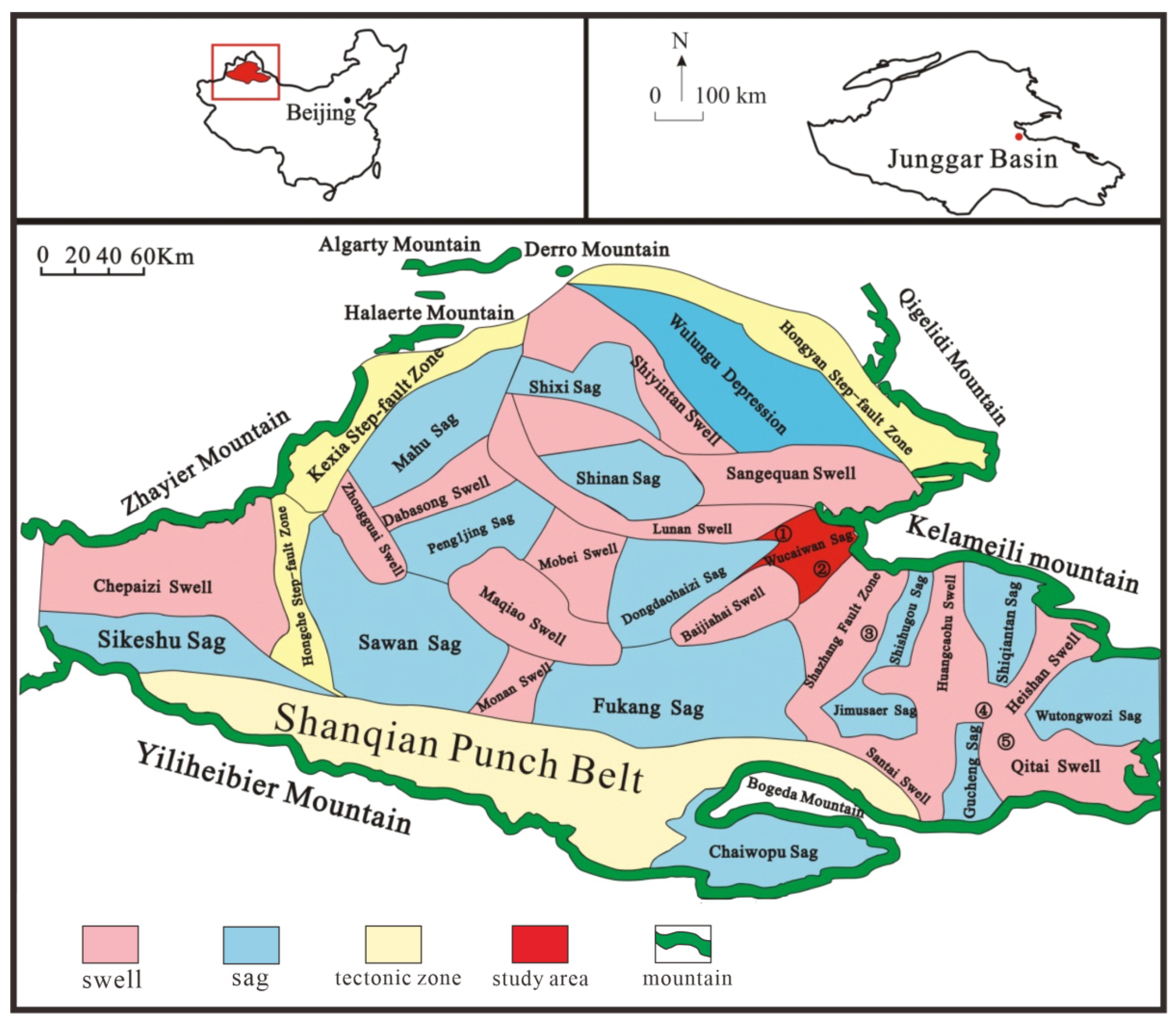
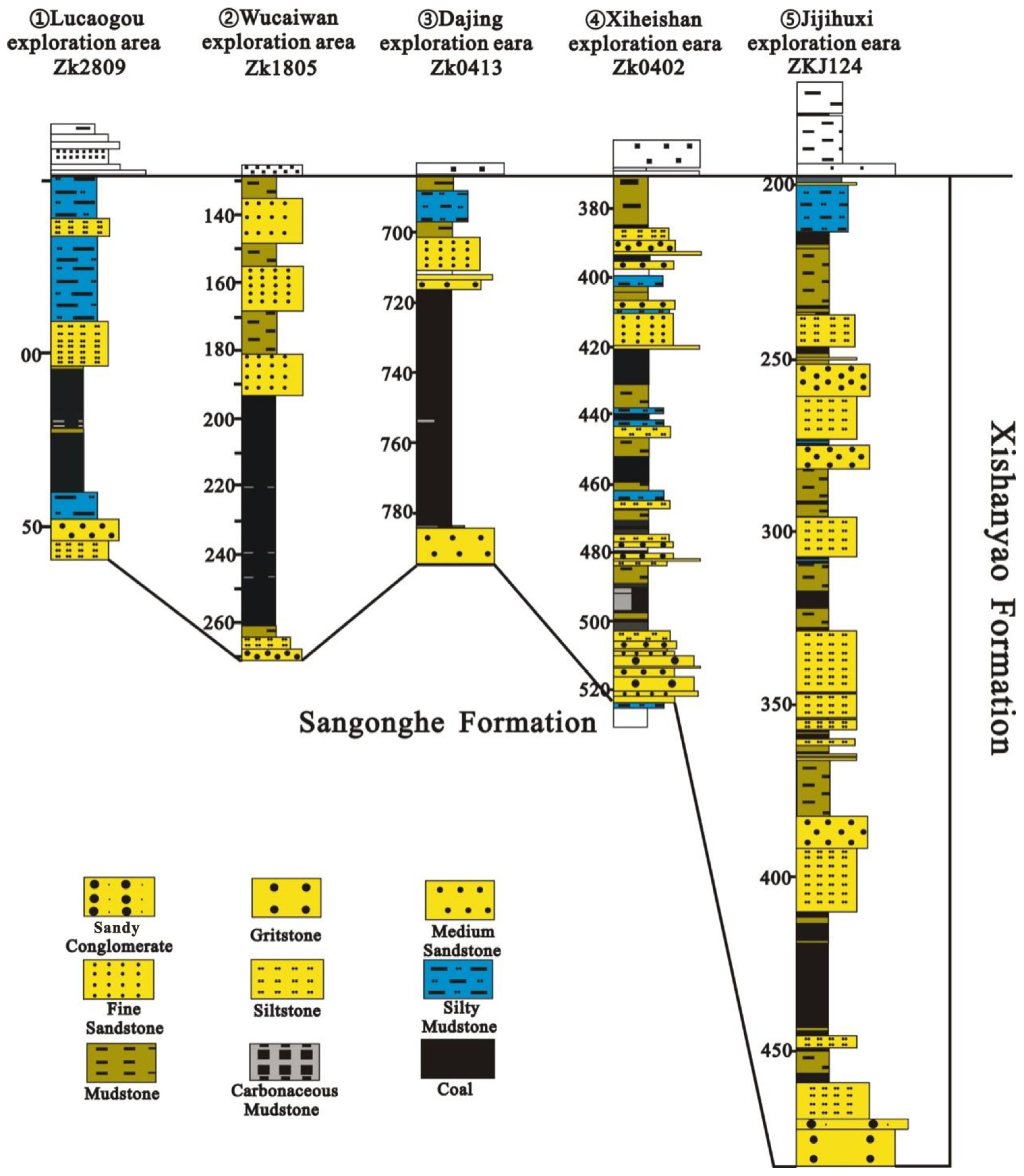
2. Geological Setting

Dzungaria Basin is located in northern Xinjiang at the junction of the Altai Mountains and Tianshan Mountains. It is bordered by the Dzungaria western mountainous region to the west and the Baytik Piedmont to the east [14]. The shape of Dzungaria Basin is an irregular triangle, with the northern part at a higher altitude than the southern part. Influenced by east–west compression stress, Dzungaria Basin has developed a series of contemporaneous sedimentary faults. The sag and salient structures trend north–east or north–south. The sag structures led to the formation of coal-bearing strata, while the salient structures did not [15,16]. The basin is rich in coal, petroleum, and gas resources. The main target for this study was the coal seam of the Aalenian Stage from the Middle Jurassic period in the Wucaiwan depression located in the eastern Dzungaria Basin [17]. The thickness of the seams in the research area is 63 m. The coal has a low ash content, low sulfur content, and high caloric value, presenting high commercial value due to the proven substantial coal reserves.
During the Indo-China Movement, the orogenic zones around the research area experienced further uplift and developed thrust nappe structures due to the proximity of the Qinling–Kunlun Ocean and the rise of the Kunlun–Qinling belt in the Late Triassic period [18,19,20]. Coal-bearing formation was minimal because of the overall uplift of the basin and mountains [21,22,23]. During the early Yanshanian period, the uplift of the basin and mountains became stable, leading to the development of broad basins and large lakes in the Early and Middle Jurassic periods, which culminated in the largest coal accumulation event [22,24,25,26,27]. During the middle and late periods of the Yanshan Movement, the reactivity and uplift of the orogenic zone in the northwest increased due to the extrusion stress from both the East Asia multi-directional convergent tectonic system in the north and the closure of the middle Tethys Ocean Basin in the south. This led to the disintegration of the large basin and the shrinkage of lake basins, accelerating the development of the reverse faults and halting the coal-bearing formation [14,17,28]. In the Aalenian Stage, the provenance mainly originated from the Kelameili Mountains in the north. The coal seams had typical district development with various coal enrichment centers. Four independent depressions were formed due to the influence of the Indo-China and Yanshan Movements: the Wucaiwan depression, the Shishugou depression, the Shiqiantan depression, and the Wutongwozi depression [29]. These depressions formed relatively independent artesian basins due to the differences in sedimentation. This study was performed in the Wucaiwan depression (Figure 1).

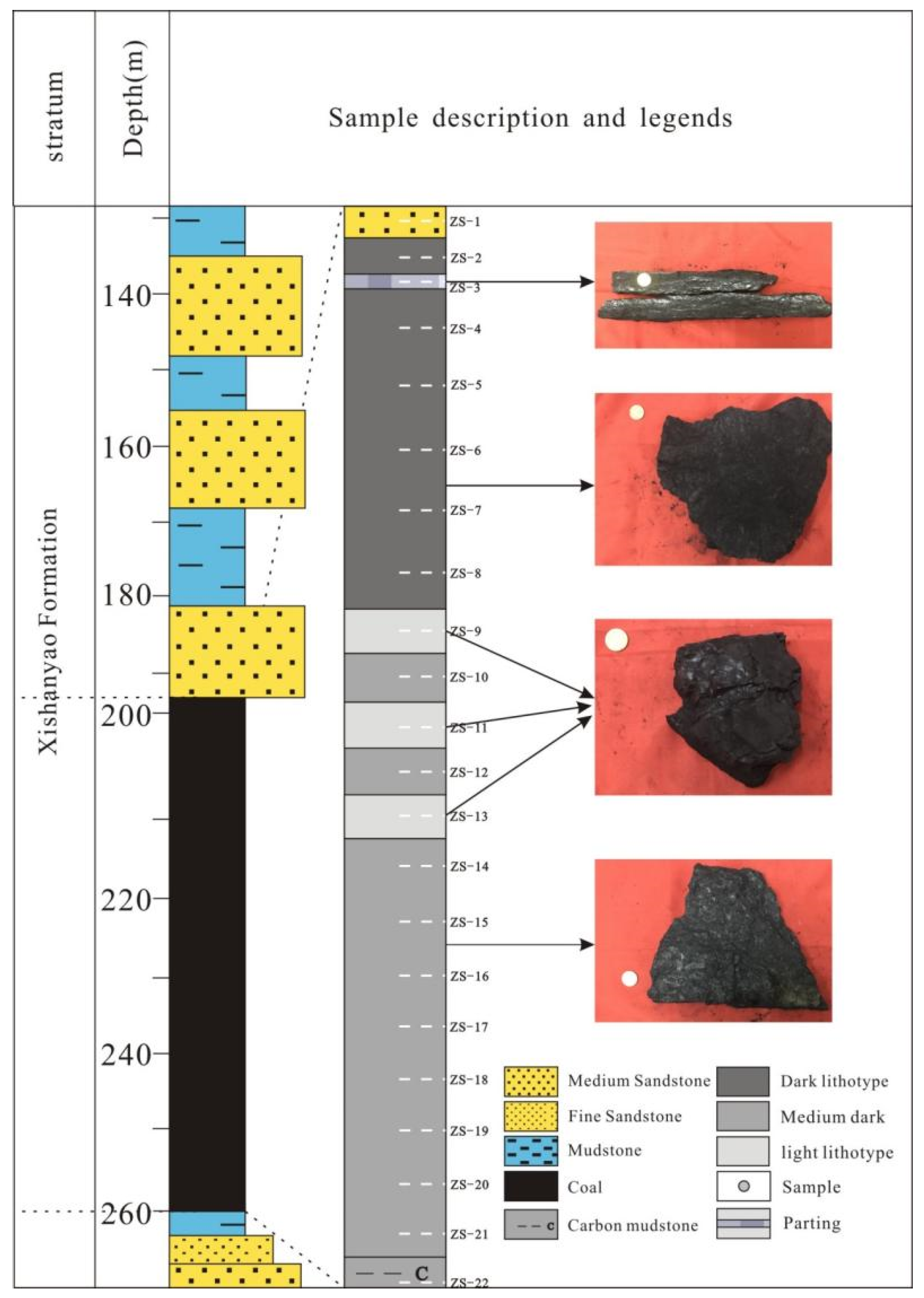
3. Materials and Methods

A total of 44 coal samples were collected from 22 coal seam sequences in the Wucaiwan coal mine in the ECDBs based on the Sampling of coal seams (GB/T 482-2008, National Standard of the People’s Republic of China) [31]. The analysis and identification of spores and pollen followed the Petroleum and Natural Gas Industry Standards of the People’s Republic of China (SY/T 5915-2000) [32] (Figure 2).
First, the coal samples were crushed to grain sizes ranging from 0.6 to 1 mm. Second, the samples were treated with three different acids: 30% HCl for 24 h, 40% HF for 4 days, and HNO3 for 6 h. These treatments removed the carbon, siliceous material, and some of the organic matter from the coal. Then, fresh water was added until the solution was neutral. The solution was then centrifugated at 2000 rpm for 5 min. Subsequently, the solution was discarded, and a new heavy liquid with a density of 2.0–2.2 g/cm3 was added. The coal samples were centrifuged at 2000 rpm for 10–30 min. Next, the coal samples were placed in fresh water for another 2 h. Finally, the spores and pollen were filtered with a screen mesh, dipped in glycerogelatin, placed on the center of a slide glass, heated, and covered with a cover glass for further preservation.
In order to visualize the contents of spores and pollen, we used Tilia v.1.7.16 software (Grimm, 2011 [33]) to draw charts based on their relative abundances and then used its built-in clustering analysis (constrained incremental sum of squares, CONISS) for regional division (Grimm, 2011 [33]). According to the CONNIS clustering analysis, three regions were identified and named A, B, and C.
The spores and pollen were observed and photographed under an Axio Scope A1 microscope (Zeiss, Jena, Germany). The identification of sporomorphs was based on The China Sporomorph (Volume II): Mesozoic Spores and Pollen [34], with additional references to the classic literature and consultations with renowned palynology experts.

4. Results

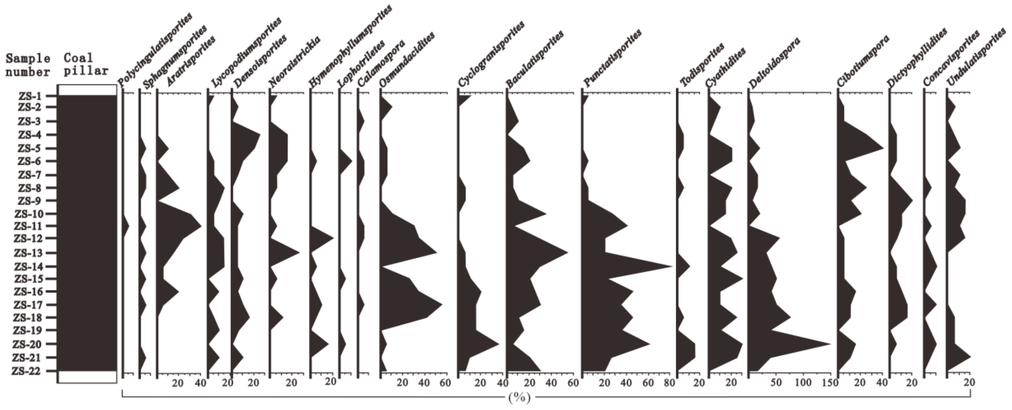
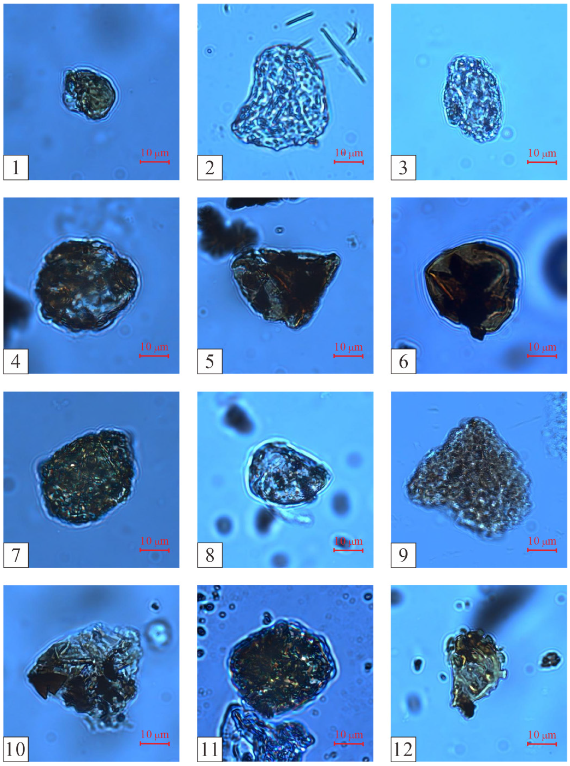
4.1. Species Composition

A total of 22 spore and pollen samples contained abundant sporomorphs (>150 grains per slide glass). The types of spores and pollen belonged to 20 families and 45 genera. Among them, ferns represented eleven families and twenty-three genera, gymnosperms represented eight families and twenty genera, and bryophytes represented one family and two genera [35] (Table 1).
The samples included the following:
Fontinalaceae: Polycingulatisporites and Sphagnumsporites;
Lycopodiaceae–Selaginellaceae: Aratrisporites, Lycopodiumsporites, Densoisporites, and Neoraistrickia;
Equisetum: Hymenophyllumsporites and Lophotriletes;
Sphenopsida: Calamospora;
Osmundaceae: Osmundacidites, Cyclogranisporites, Baculatisporites, Punctatisporites, and Todisporites;
Cyatheaceae: Cyathidites and Deltoidospora;
Dicksoniaceae: Cibotiumspora;
Dipteridaceae: Dictyophyllidites and Concavisporites;
Gleicheniaceae: Gleicheniidites;
Lygodiaceae: Cicatricosisporites and Klukisporites;
Ophioglossaceae: Undulatisporites;
Polypodiaceae: Polypodiisporites and Laevigatosporites;
Pteridospermae: Caytonipollenites and Alisporites;
Cycadaceae: Eucommiidites, Monosulcites, and Cycadopites–Chasmatosporites;
Araucariaceae: Araucariacites;
Podocarpaceae: Podocarpidites;
Cupressaceae: Perinopollenites;
Cheirolepidiaceae: Classopollis;
Pinaceae: Pinuspollenites, Cedripites, Pseudopicea, Laricoidites, Protopinus, Rugulatisporites, and Piceaepollenites;
Pinaceae, unknown classification: Pristinuspollenites, Rugubivesiculites, Quadraeculina, and Cerebropollenites.

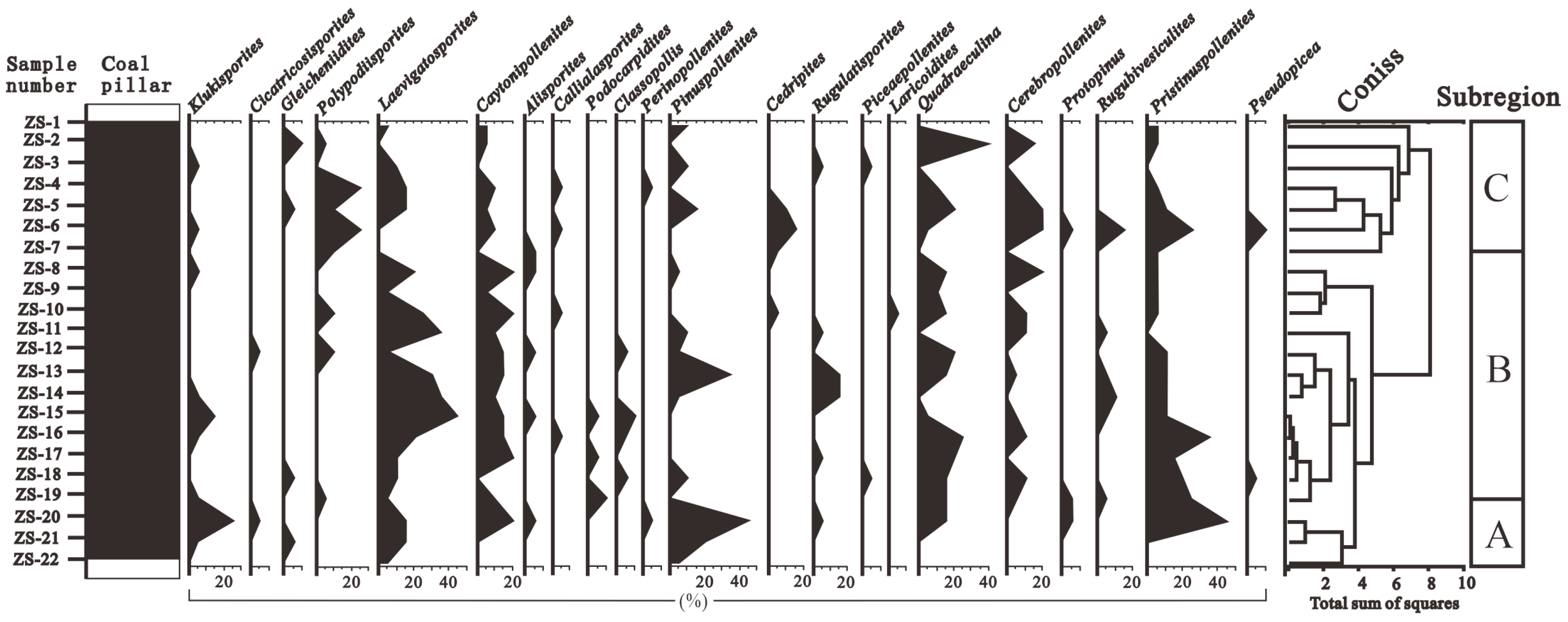
4.2. Combination of Spores and Pollen

Based on the changes in the vertical abundance of pollen, and using the CONISS algorithm of the Tilia software to cluster and analyze the pollen data, the thick coal seams in the Wucaiwan mining area of Zhundong were divided into three zones from the bottom to the top: A, B, and C (Figure 3 and Figure 4; [33]).

4.2.1. Group A

The sedimentary thickness of Group A was 9 m, which included three spore and pollen samples, labeled ZS-20 to ZS-22. Group A contained eighteen fern, eight gymnosperm, and one bryophyte genera.
The proportion of fern plants ranged from 26.67% to 49.43%, averaging 40.61%. The dominant species were Osmundaceae (Figure 5(1–4)) and Cyatheaceae (Figure 5(5,6)), ranging from 8.48 to 34.29% and from 7.88 to 20.11%, respectively, followed by Polypodiaceae (1.72–2.86%) plants. Other ferns had relatively low contents and no obvious changes, for example, Lycopodiaceae–Selaginellaceae (Figure 5(7–12)), Sphenopsida (Figure 6(13)), Dipteridaceae (Figure 6(14,15)), and Dicksoniaceae. Gymnosperms occupied a proportion ranging from 11.43% to 34.5%, with an average of 19.96%. Cycadaceae (Figure 6(16–20)) were the dominant species, ranging from 8.57% to 20.12%, followed by Pinaceae (Figure 6(21,22)) and unclassified Pinaceae plants (Figure 6(23)), with proportions ranging from 2.42% to 6.33% and from 0% to 6.89%, respectively (Table 1).

4.2.2. Group B

The sedimentary thickness of Group B was 36 m, which included 12 spore and pollen samples, labeled ZS-8 to ZS-19. Group B contained twenty-three fern, nineteen gymnosperm, and two bryophyte genera. Compared with Group A, Group B was more abundant in paleovegetation types.
The ratio of ferns ranged from 38.78% to 57.13% (average of 50.21%). The dominant species included Lycopodiaceae–Selaginellaceae (3.06–12.22%), Osmundaceae (4.80–27.55%), and Cyatheaceae (0–16.52%) plants, followed by Dipteridaceae, Polypodiaceae, Ophioglossaceae, and Hymenophyllaceae. Group B also contained a minor proportion of Lygodiaceae plants and Gleicheniaceae. The gymnosperms occupied a proportion ranging from 13.96% to 43.91%, with a slight increase and an average of 26.48%. The Cycadaceae (6.96–24.10%), unclassified Pinaceae (3.33–19.69%), and Pinaceae (0–8.70%) plants were the dominant species among the gymnosperms. Cheirolepidiaceae (Figure 6(24)) and Podocarpaceae plants were also present. The number of bryophytes ranged from 0% to 2.22%, with an average of 0.51%; Fontinalaceae plants were the dominant species (Table 1).

4.2.3. Group C

The sedimentary thickness of Group C was 18 m, which included seven spore and pollen samples, labeled ZS-1 to ZS-7. Group C contained twenty-one fern, seventeen gymnosperm, and one bryophyte genera.
The number of ferns varied from 30.44% to 63.41% (average 42.26%). The dominant species were Osmundaceae (2.44–13.04%), Lycopodiaceae–Selaginellaceae (0–19.51%), Cyatheaceae (0–10.72%), and Polypodiaceae (3.33–19.51%). The gymnosperms occupied a proportion ranging from 26.84% to 54%, with an average of 43.84%. The Cycadaceae (9.76–37.49%), Pinaceae (0–14.29%), and unclassified Pinaceae (0–40%) plants were the dominant species among the gymnosperms. The number of bryophytes ranged from 0% to 2.08%, with an average of 0.45%; they were sporadically distributed in various coal seams (Table 1).

5. Discussion

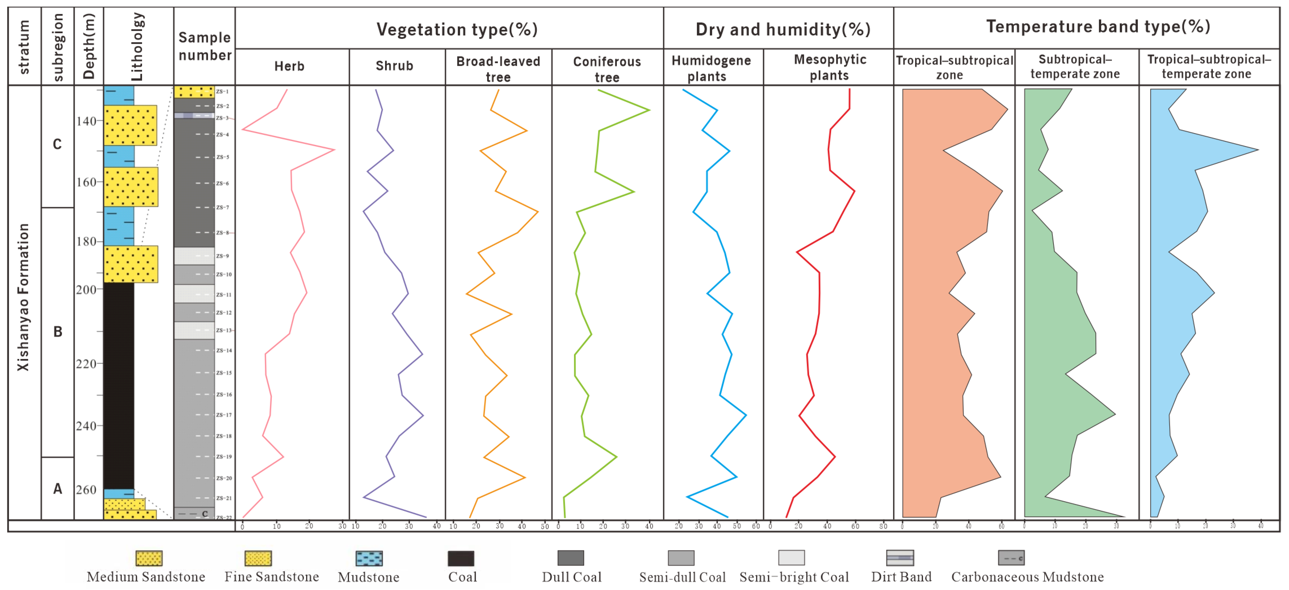
5.1. Characteristics of Paleovegetation

The spore and pollen vegetation types were classified into coniferous trees, evergreen broad-leaved trees, deciduous broad-leaved trees, shrubs, and herbs [38,39]. In the present study area, the paleovegetation mainly comprised herbs, shrubs, broad-leaved trees, and coniferous trees. The herbs included Fontinalaceae, Lycopodiaceae–Selaginellaceae, Hymenophyllaceae, and Ophioglossaceae; the shrubs included Osmundaceae, Cyatheaceae, Dipteridaceae, Sphenopsida, Gleicheniaceae, Lygodiaceae, and Polypodiaceae; the broad-leaved trees included Dicksoniaceae and Cycadaceae; the coniferous trees included Pteridospermae, Araucariaceae, Podocarpaceae, Cupressaceae, Cheirolepidiaceae, and Conifers (Table 2).
According to the relationship between modern spores and pollen and the vegetational cover, some pollen, such as that from Pinaceae and Cupressaceae plants, was transported over long distances [40,41]. Although some spores and pollen were the result of long-distance transportation, the data on the spores and pollen can still be used to reconstruct the types of paleovegetation in the extra-thick coal seams from the Aalenian Stage in the ECDBs [42,43]. Therefore, the vertical succession of paleovegetation in the Aalenian Stage in the ECDBs was divided into three groups (Figure 3 and Figure 4; [33]).
Shrubs (20.62–45.72%) and broad-leaved trees (8.57–21.48%) were the dominant paleovegetation in Group A, and herbs (0–5.95%) and coniferous trees (2.42–14.38%) appeared less frequently at this stage. Ferns were at their peak, and gymnosperms were not predominant. The shrubs were mainly of the Osmundaceae (Baculatisporites) family, and the broad-leaved trees were mainly of the Cyatheaceae (Deltoidospora) and Cycadaceae (Cycadopites–Chasmatosporites) families [44,45,46].
The abundance of paleovegetation in Group B was higher than that in Group A due to the increased variety of gymnosperms. Shrubs (26.50–47.95%) remained the dominant paleovegetation, and broad-leaved trees (7.83–21.05%) decreased, while herb plants (5.79–18.88%) and coniferous trees (6.98–25.95%) increased. The shrubs were mainly from the Osmundaceae (Baculatisporides and Punctisporites) family, followed by the Polypodiaceae (Laevigatosporites) and Dipteridaceae (Dictyophyllidities) families. The number of ferns and broad-leaved trees decreased, while the changes in the Cycadaceae were not significant but still dominated by these two plants. The additional herbs were mainly from the Lycopodiaceae–Selaginellaceae (Aratrisporites, Neoraistrickia,) and Hymenophyllaceae (Lophotrilets) families, while the additional coniferous trees were mainly from the Conifers (Podocarpidites, Classopollis, Pristinuspollenites, Rugubivesiculites, and Cerebropollenites) family (Table 1).
In Group C, the proportion of shrubs (17.39–30.00%) decreased, while herbs (0–26.83%), broad-leaved trees (16.66–41.66%), and coniferous trees (8.32–40.00%) all increased. The number of gymnosperms increased sharply, while the number of ferns decreased sharply. At this point, the content of ferns was equivalent to that of gymnosperms. The shrubs were mainly from the Osmundaceae (Osmundachidites, Baculatiporites) and Polypodiaceae (Polypodisporites, Laevigatosporites) families, followed by the Sphenopsida (Calamospora). The herbs were still mainly from the Lycopodiaceae–Selaginellaceae (Densonisporites, Neoraistrickia) family, followed by the Hymenophyllaceae (Lophotrilets) and Ophioglossaceae (Undulatosporites) families. The broad-leaved trees were mainly from the Cycadaceae (Cycadopies–Chasmatosporites) family, with a significant decrease in the number of Cyatheaceae but a significant increase in the Dicksoniaceae (Cibotiumspora) family. The coniferous trees were still mainly composed of Conifers (Pinuspollenites, Cedripites, Pristinuspollenites, Quadraeculina, and Cerebrollenites). The abundance of pine and cypress plants reached its peak here (Table 1).
Compared with the paleovegetation in Yaojie of Gansu and the Dongsheng District of Erdos in Inner Mongolia, the number of Cyatheaceae plants in the study area was low, whereas that of Osmundaceae and Cladosporidae plants was high [36,37]. The number of gymnosperms from the extra-thick coal in the ECDBs was lower at the bottom of the coal seam but higher at the top. However, the number of gymnosperms in Yaojie was lower in the middle layer, which was different from that observed in the ECDBs. Additionally, the number of cycads was also higher than that in Yaojie and Dongsheng, whereas Pinaceae plants were dominant in Yaojie and Dongsheng [36,37]. Ferns developed in the ECDBs, but gymnosperms were more abundant in Yaojie and Dongsheng. Although two-bursa coniferous Pinaceae and broad-leaved Gymnospermae plants were developed in all three areas, Pteridospermae and Podocarpaceae plants developed in Yaojie and Dongsheng. The development of Cupressaceae plants in the Middle Jurassic period was significantly different from that in the ECDBs and Dongsheng (Table 1).
In summary, the paleovegetation in the ECDBs mainly included herbs of Lycopodiaceae–Selaginellaceae plants, shrubs of Osmundaceae and Polypodiaceae plants, broad-leaved trees of Cyatheaceae and Cycadaceae plants, and coniferous trees of pine and cypress plants. From the bottom to the top, the number of herbs and coniferous trees showed a continuous increase.

5.2. Characteristics of Paleoclimate

The spores and pollen in the dry–humid zone were classified into xeric, mesophytic, humidogenic, aquatic, and paludose plants [47,48,49]. By analyzing the impact of dryness and wetness, environmental changes were inferred, providing theoretical support for paleoclimate restoration. The spores and pollen in the climate zone were classified into tropical, subtropical, temperate, warmzone–subtropical, and tropical–temperate plants [47]. In this study, we divided the dry–humid zone into four categories: xeric, mesophytic, humidogenic, and aquatic. The proportions of temperate and subtropical plants in the research area were relatively low, so the area was classified as subtropical–temperate. During the statistical analysis, it was found that the aquatic plants included Fontinalaceae; the humidogenic plants included Hymenophyllaceae, Sphenopsida, Osmundaceae, Cyatheaceae, Dicksoniaceae, Dipteridaceae, Gleicheniaceae, Lygodiaceae, Ophioglossaceae, Polypodiaceae, Podocarpaceae, and Cupressaceae; the mesophytes included Lycopodiaceae–Selagioellaceae, Cycadaceae, and Pineaceae; and the xerophytes included Pteridospermae, Araucariaceae, and Cheirolepidiaceae [35,36]. In this study, the vegetation types, dry–humid zones, and climate zones were selected as the criteria to explore the features of the paleoclimate during the coal-bearing period of the extra-thick coal seams in the Aalenian Stage of the ECDBs (Table 2).
Due to the relatively single trend of aquatic and xeric plants, which only appeared in some layers, we only made trend charts for humidogenic and mesophytic plants (Figure 7). We found that humidogenic plants showed an overall downward trend from the bottom to the top, while mesophytic plants showed an overall upward trend. Humidogenic plants ranged from 24.25% to 50.01% in Group A, from 34.44% to 55.09% in Group B, and from 21.74% to 46.34% in Group C. They were at their peak in ZS-4, ZS-10, ZS-12, ZS-14, ZS-17, and ZS-20, indicating that plants that prefer moisture, such as plants of the Osmundaceae, Cyatheaceae, Dicksoniaceae, and Polypodiaceae families, grew vigorously during this stage. Mesophytes ranged from 11.43% to 33.34% in Group A, from 18.62% to 45.91% in Group B, and from 41.47% to 60.34% in Group C. In Groups C and B, the peak of mesophytes at ZS 19 indicates that plants such as Pinaceae and Lycopodiaceae–Selaginellaceae grew vigorously.
Modern Filicinae plants are mainly distributed in tropical–subtropical zones. Deltoidospora and Cyathidites plants, belonging to the Cyatheaceae family, are broad-leaved plants living in tropical and subtropical humid areas [50,51]. Filicinae plants also include fossils of Dipteridaceae plants, which originated in the Late Triassic period. Dipteridaceae plants were found in the Late Jurassic period and were mainly distributed in the humid zone, with some distribution in the fluctuating tropical and subtropical zones during the Mesozoic period [52]. Lycopodiaceae plants now grow in tropical, subtropical, and temperate zones with humid climates; they are found in coniferous or coniferous broad-leaved mixed forests or among shrubs [53]. Selaginellaceae plants are mainly distributed in tropical, subtropical, and temperate zones and grow in wetlands, typically in the undergrowth or near streams [54]. Cheirolepidiaceae plants mainly grow in dry and hot climates, indicating a change in the paleoclimate from humid to dry conditions [52,55]. Podocarpidites plants are coniferous plants growing in semi-dry–semi-humid areas in tropical–subtropical zones. Cycadopites plants are broad-leaved plants growing in semi-dry–semi-humid areas in tropical–subtropical zones. Alisporites, Pinuspollenites, Erlianpollis, Piceaepollenites, Piceites, Pseudopicea, and Cedripites plants are coniferous plants growing in semi-dry–semi-humid areas in tropical–subtropical zones [56].
The relationships among the plant composition, dry–humid zones, and climate zone types show that the proportion of shrubs continuously decreased from the bottom to the top of the coal seam, peaked at the bottom of Group B, and then decreased in Group C. The number of coniferous plants increased continuously from Group A to Group C. In Group A, the number of coniferous plants was low. The number increased steadily in Group B and then displayed a sharp increase and peaked in Group C. The numbers of broad-leaved plants and herbs were insignificant for the whole area, but the number of herbs increased in Group B. The dry–humid zone showed an obvious change from the bottom to the top of the coal formation. A large number of humidogenic plants were found in Group A, but they decreased continuously. Conversely, the number of mesophytic plants increased. The number of xeric plants was lower in Group A; they began to appear in Group B and peaked in Group C. The growth habits of various plants indicate that the abundance of vegetation in the tropical–subtropical–temperate zone reached 30% and stayed around 15%. The subtropical–temperate plants mainly existed at the bottom of the coal seam, with an extremely low number at the top of the coal seam. The proportion of plants in the tropical–subtropical zone was higher than 40% and even reached up to 60% (Table 1 and Figure 7).
The paleoclimate in the study area experienced three stages according to the modern distribution of the main palynoflora, the dry–humid features, and the distribution of the climate zones. These three stages are warm–humid, humid–semi-humid, and semi-humid–semi-dry. The paleoclimate was mainly tropical–subtropical (Figure 7). A study on the paleoclimate of the Aalenian Stage in the middle-western Dzungaria Basin showed that the early Aalenian Stage presented a warm–humid climate. During the middle Aalenian Stage, the Pinaceae plants exhibited extremely vigorous growth, and the number of Cheirolepidiaceae plants increased, indicating that the paleoclimate became dry and hot [57,58]. This is consistent with the results of this study. During the Middle Jurassic period, the paleoclimate of the Yaojie area was mainly characterized by a transition between the semi-dry–semi-humid tropical–subtropical zone in the southeast and the dry tropical–subtropical zone in the southwest. The paleoclimate was not stable because of the seasonal transformation of the climate zone. Additionally, it changed from a warm–semi-humid state to a dry–humid state and, finally, to a cool–humid state. Large amounts of spores and pollen originated from the warm and wet plants in Donsheng, which implies a warm–humid climate with abundant plant growth. However, mesophytic Pinaceae plants also developed during the mid-Aalenian Stage [35,36].
During the Triassic–Jurassic Boundary period, the atmospheric CO2 levels increased rapidly. Additionally, intensive volcanic activity related to the Central Atlantic Magmatic Province also released large amounts of CO2. The resulting acute greenhouse effect led to global warming [59]. The rise in temperature increased the water vapor content in the upper troposphere. The amount of vapor in the upper troposphere was positively correlated with global lightning activity, leading to frequent forest fires [60,61,62,63,64]. Therefore, it can be deduced that the heating event in the Jurassic period may have been related to the occurrence of forest fires. In the early Aalenian Stage, the lake basin expanded continuously. This expansion of the sedimentary range led to differences in the altitude across the basin [65]. The developing hydrographic network from the Kelameili Mountains increased the water level in the lake. The increase in the lake surface area led to a humid environment, which encouraged the growth of shrubs and herbs. In the middle of the depositional stage, the expansion of the lake ceased, and the paleoclimate changed to the humid–semi-humid type [66]. During this time, the number of Pinaceae plants increased, whereas the number of ferns decreased. In the late depositional stage, differential uplift occurred in the basin, the lake bog shrank, and the paleoclimate became dry and hot. The hydrographic changes from the Kelameili Mountains decreased, leading to a continuous drop in the lake water level. The change in the paleoclimate led to the growth of coniferous plants [67]. Cyatheaceae and Dicksoniaceae plants were broad-leaved ferns of Filicinae that primarily grew in warm–humid zones. The decrease in the number of Cyatheaceae plants from the bottom to the top further validates the change in the paleoclimate from warm–humid to dry–hot [68,69,70]. Cheirolepidiaceae were seasonal xeric plants, including Classopollis, which mainly grew on slopes. These xeric plants were less abundant in Group C but increased in proportion in Group B, which further proves the change in the paleoclimate.
In conclusion, the study area experienced a heating event, which led to large-scale lake transgression and retreat during the depositional stage of the Aalenian Stage. The paleoclimate transitioned from warm–humid to tropical–subtropical to humid–semi-humid and, finally, to semi-humid–semi-dry.

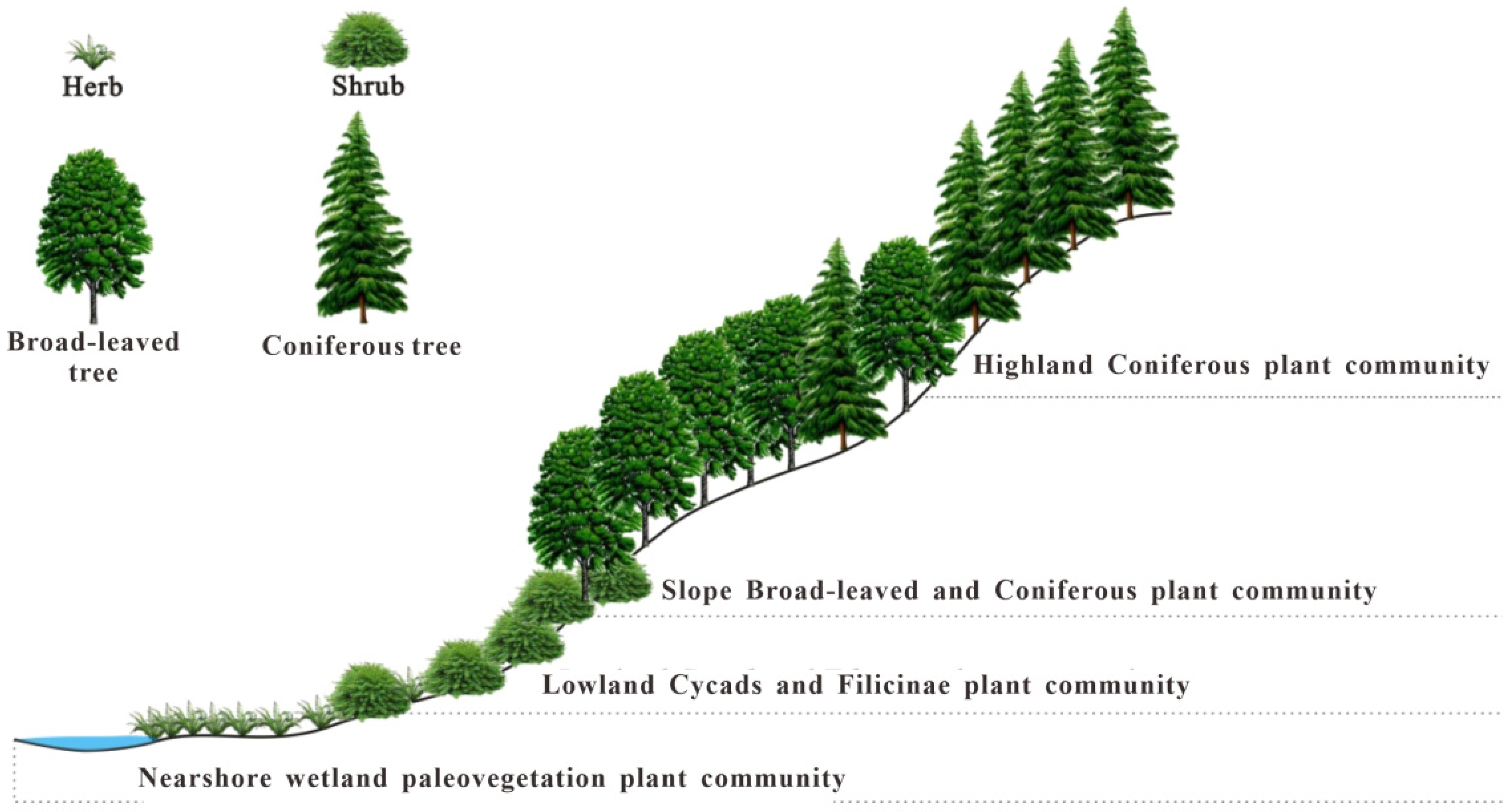
5.3. Reconstruction of the Paleovegetation Community

Based on the previous findings, the paleovegetation community of the extra-thick coal seam of the Xishayao Formation in the ECDBs was reconstructed. Typically, the nearshore wetland and lowland plant communities included in situ-buried plants, which were mainly coal-bearing plants. The seeds, spores, and pollen from the Pinaceae plants in the abrupt slope and highland zones were transported to the depositional areas by wind and water, resulting from allochthonous transportation [35,71,72].

5.3.1. Nearshore Wetland Paleovegetation Community

These plants were mainly distributed along the damp banks of lakes and rivers and in the undergrowth. The swampland and the low-lying humid areas were also favorable for the growth of these plants. These plants were mainly wetland plants with weak hydrodynamic conditions [35], enabling sporomorphs to be preserved in situ. The dominant species included Sphenopsida, Equisetum, and some Pteridophyta and Musci plants, such as Calamospora, Hymenophyllumsporites, Undulatisporites, Cicatricosisporites, Klukisporites, and Sphagnumsporites. This plant community was simple and had low herbaceous growth (Figure 8).

5.3.2. Lowland Cycad and Filicinae Plant Community

This plant community was mainly found in areas with slight undulation, damp soil, and good permeability. It comprised Filicopsida and Cycadopsida plants, including Osmundacidites, Cyclogranisporites, Baculatisporites, Punctatisporites, Todisporites, Aratrisporites, Lycopodiumsporites, Neoraistrickia, Cyathidites, Deltoidospora, Cibotiumspora, Dictyophyllidites, Concavisporites, Gleicheniidites, Polypodiisporites, Laevigatosporites, Cycadopites, Monosulcites, and Eucommiidites. These plants were shrubs and broad-leaved trees, with Bennettitinae being one of them. The species diversity of Filicinae plants was high, so they were the dominant species in this community. The appearance and structure of this community included prolific Filicinae plants, low herbaceous Filicinae plants, shrubs, and low xylophytes. Overall, this plant community comprised shrubs and ferns under broad-leaved trees (Figure 8).

5.3.3. Slope Broad-Leaved and Coniferous Plant Mixed Community

This plant community was distributed around mountainous slopes or hills inside the basin. With steeper slopes and good permeability, the dominant plants included coniferous and broad-leaved mesophytes, comprising both trees and shrubs. Herbaceous Filicinae plants grew under the vegetation and along the damp hillside edge. Cycads, Cupressaceae, and Pinaceae plants were dominant species, including Podocarpidites, Pinuspollenites, Laricoidites, Rugubivesiculites, Pseudopicea, Quadraeculina, Cerebropollenites, and Perinopollenites. In this community, coniferous Pinaceae plants occupied the high hillside slopes, the middle hillside slopes had mixed coniferous and broad-leaved trees, and the lower hillside slopes mainly had broad-leaved trees and shrubs. Meanwhile, ferns still grew in the wet belt between the forest and valley slopes (Figure 8).

5.3.4. Highland Coniferous Tree Community

This plant community grew at the top of the mountains or in high areas inside the basin. The dominant species were Cupressaceae and Pinaceae plants, including Piceaepollenites, Cedripites, and Callialasporites. Xeric plants from Cheirolopidiaceae and Pteridospermae, such as Caytonipollenites and Alisporites, also grew here. This plant community mainly grew in relatively high-altitude areas with low temperatures and relatively dry soil [67]. Additionally, the coniferous vegetation structure was simple, with fewer humidogenic herbs and shrubs (Figure 8).

5.4. Formation and Thinning of Extra-Thick Coal Seams

The accumulation and formation of peat swamps are determined by two basic conditions: (1) prosperous plant communities in the swamps and (2) sufficient space and good preservation conditions for the accumulation of peat layers [73,74]. Due to the ferns flourishing in the study area, the growing environment comprised mixed swamps, which facilitated rapid accumulation and preservation. The corresponding paleovegetation communities included the nearshore wetland paleovegetation community, the lowland cycads, and the Filicinae plant community. However, the slope broad-leaved and coniferous plant mixed community and highland coniferous tree community included mainly gymnosperms and broad-leaved ferns. The plant remains from these communities were transported over long distances with their sources. Therefore, it is presumed that the plant remains on the slopes and plateaus carried by water are located in the middle and south of the ECDBs. The scale of transgressions plays a significant role in the accumulation of peat swamps. Coal with economic value can only form when the rate of increase in accommodation space caused by transgression approaches or slightly exceeds the rate of peat accumulation [75]. If the transgression rate is high enough to submerge the peat swamps, plant growth is inhibited, resulting in the formation of shallow lake sediments [76]. Similarly, peat swamps are oxidized in a regressive environment. Neither condition is conducive to the formation or development of peat swamps. Due to a warming event in the Middle Jurassic period, the coal seam in the Aalenian Stage underwent large-scale lake transgression and regression during deposition, accompanied by the transfer of the coal-accumulating center. During the early stage of the expansion of the lake basin from the southeast to the northeast, the coal-accumulating center migrated from the east to the west and southwest of the ECDBs. In the later stage of lake basin shrinkage, the coal-accumulating center migrated to the middle and southeast of the Dajing mining district [77]. These depositional features determined the formation of the extra-thick coal seams in the Wucaiwan and Dajing mining districts northwest of the ECDBs. The periodic small-scale transgressive–regressive cycles resulted in a large number of thin coal seams in the east and southeast of the ECDBs (Figure 1 and Figure 9).

6. Conclusions

The conclusions of this study are as follows:
(1)
The types of spores and pollen belong to forty-five genera, including twenty-three fern, twenty gymnosperm, and two bryophyte genera, in the extra-thick coal seams (Aalenian Stage) of the ECDBs, with ferns as the main spore and pollen fossils, followed by gymnosperms. The paleovegetation types in the study area mainly included Lycopodiaceae–Selaginellaceae herbs, Osmundaceae and Polypodiaceae shrubs, and Cyatheaceae, Cycadaceae, and Pinaceae coniferous broad-leaved trees. From the bottom to the top, the number of ferns increased first and then decreased, and the number of gymnosperms continued to increase. The number of herbs and Pinaceae plants showed a continuous increase.
(2)
During the sedimentary period, the paleoclimate of the Aalenian Stage in the ECDBs changed from warm–humid to humid–semi-humid and, finally, to semi-humid–semi-dry, all within the tropical–subtropical zone.
(3)
The study area was divided into four paleovegetation communities: nearshore wetland paleovegetation community, lowland cycad and Filicinae plant community, mixed community of slope broad-leaved and coniferous trees, and highland coniferous tree community. The nearshore wetland paleovegetation community and lowland cycad and Filicinae plant community were the main coal-forming plant communities in the study area.
(4)
According to the analysis of the characteristics of paleovegetation types and the paleoclimate succession model, a warming event occurred in the Dzungaria Basin during the Middle Jurassic period. This event resulted in large-scale lake transgression and regression in the basin, leading to a shift in the coal-accumulating center from the west and southwest to the central part of the ECDBs.

Author Contributions

Conceptualization, X.W.; Methodology, X.W., W.W., Q.Z., J.T., C.H. and M.W.; Software, X.W. and W.W.; Investigation, X.W. and W.W.; Resources, S.F.; Data curation, X.W.; Writing—original draft, X.W.; Writing—review & editing, X.W., S.F. and Q.Z.; Funding acquisition, S.F. and J.T. All authors have read and agreed to the published version of the manuscript.

Funding

This research was funded by [National Natural Science Foundation of China] grant number (Grant No. 42162017); [Science and Technology Program of Xinjiang Uygur Autonomous Region] grant number (2023D04056); [Major Scientific and Technological Project in the Xinjiang Uygur Autonomous Region] grant number (2022A03014); and [Xinjiang Uygur Autonomous Region “Tianshan Talent” Youth Top Talent Project] grant number (2023TSYCCX0009). The APC was funded by [National Natural Science Foundation of China].

Data Availability Statement

Data is contained within the article.

Conflicts of Interest

The authors declare no conflict of interest.

References

  1. Liu, F.; Peng, H.P.; Bomfleur, B.; Kerp, H.; Zhu, H.C.; Shen, S.Z. Palynology and vegetation dynamics across the Permian-Triassic boundary in southern Tibet. Earth-Sci. Rev. 2020, 209, 103278. [Google Scholar] [CrossRef]
  2. Li, S.-F.; Valdes, P.J.; Farnsworth, A.; Davies-Barnard, T.; Su, T.; Lunt, D.J.; Spicer, R.A.; Liu, J.; Deng, W.-Y.-D.; Huang, J.; et al. Orographic evolution of northern Tibet shaped vegetation and plant diversity in eastern Asia. Sci. Adv. 2021, 7, eabc7741. [Google Scholar] [CrossRef]
  3. Korasidis, V.A.; Wallace, M.W.; Wagstaff, B.E.; Holdgate, G.R.; Tosolini, A.-M.P.; Jansen, B. Cyclic floral succession and fire in a Cenozoic wetland/peatland system. Palaeogeogr. Palaeoclimatol. Palaeoecol. 2016, 461, 237–252. [Google Scholar] [CrossRef]
  4. Korasidis, V.A.; Wallace, M.W.; Dickinson, J.A.; Hoffman, N. Depositional setting for Eocene seat earths and related facies of the Gippsland Basin, Australia. Sediment. Geol. 2019, 390, 100–113. [Google Scholar] [CrossRef]
  5. Singh, A.K.; Kumar, A. Assessment of Thermal Maturity, Source Rock Potential and Paleodepositional Environment of the Paleogene Lignites in Barsingsar, Bikaner–Nagaur Basin, Western Rajasthan, India. Nat. Resour. Res. 2020, 29, 1283–1305. [Google Scholar] [CrossRef]
  6. Rajak, P.K.; Singh, V.K.; Singh, P.K.; Singh, A.L.; Kumar, N.; Kumar, O.P.; Singh, V.; Kumar, A. Geochemical implications of minerals and environmentally sensitive elements of Giral lignite, Barmer Basin, Rajasthan (India). Environ. Earth Sci. 2018, 77, 698. [Google Scholar] [CrossRef]
  7. Wu, T.; Wang, J.; Yang, T. Discoveryand Sedimentary Environment of Sporopollen Fossils at Jurassic Yangye Formation in East Subashi, West Kunlun. Northwestern Geol. 2018, 51, 44–53. [Google Scholar]
  8. Hou, M.-G.; Zha, M.; Ding, X.-J.; Yin, H.; Bian, B.-L.; Liu, H.-L.; Jiang, Z.-F. Source and accumulation process of Jurassic biodegraded oil in the Eastern Junggar Basin, NW China. Pet. Sci. 2021, 18, 1033–1046. [Google Scholar] [CrossRef]
  9. Cheng, D.; Zhou, C.; Zhang, Z.; Yuan, X.; Liu, Y.; Chen, X. Paleo-environment reconstruction of the middle permian lucaogou formation, southeastern Junggar Basin, NW China: Implications for the mechanism of organic matter enrichment in ancient lake. J. Earth Sci. 2022, 33, 963–976. [Google Scholar] [CrossRef]
  10. Dong, M.; Sun, G. Middle Jurassic plant from Shaerhu Coalfield of Xinjiang, China. Glob. Geol. 2011, 30, 497–507. [Google Scholar]
  11. Huang, P. Early-Middle Jurassic Sporopollen Assemblages From Dananhu Coalfield of Tuha Basin, Xinjiang and Their Stratigraphical Significance. Chin. Sci. Abstr. Ser. B 1995, 34, 171–197. [Google Scholar]
  12. Stachacz, M.; Kondas, M.; Filipiak, P.; Ma, X. Environment and Age of the Upper Devonian–Carboniferous Zhulumute and Hongguleleng Formations, Junggar Basin, NW China: Ichnological and Palynological Aspects. Acta Geol. Sin.-Engl. Ed. 2021, 95, 724–739. [Google Scholar] [CrossRef]
  13. Zong, P.; Becker, R.T.; Ma, X. Upper Devonian (Famennian) and Lower Carb (Tournaisian) ammonoids from western Junggar, Xinjiang, northwestern China—Stratigraphy, taxonomy and palaeobiogeography. Palaeobiodiver. Palaeoenviron. 2015, 95, 159–202. [Google Scholar] [CrossRef]
  14. Zhang, X. Types and tectonic evolution of Junger Basin. Earth Sci. Front. 2000, 7, 431–440. [Google Scholar]
  15. Chen, L.; Shao, P.; Xiong, W.; Qi, W.; Zhang, S. Discussion on distribution and occurrence mechanism of gallium in the Middle Jurassic coal-bearing strata of the eastern Junggar coalfield, Xinjiang. Earth Sci. Front. 2018, 25, 76. [Google Scholar]
  16. Cheng, S.; Wang, Y. Basic characteristics of geotectonic evolution of Xinjiang. Xinjiang Geol. 1998, 16, 97–107. [Google Scholar]
  17. Wang, D.; Wang, X.; Ji, Q. The palynoflora alternation and the paleoclimate change at the turning time between Late Jurassic and Early Cretaceous in northern Hebei and western Liaoning. Acta Geosci. Sin. 2016, 37, 449–459. [Google Scholar]
  18. Li, H.; Gao, R.; Huang, X.; Wang, H.; Guo, X.; Liang, H.; Tan, X.; Liu, X.; Yang, Z. Triassic convergence and tectonic evolution of the West Qinling orogen: Constraints from reflection-seismology imaging. Gondwana Res. 2023, 122, 1–10. [Google Scholar] [CrossRef]
  19. Lu, H.; Wang, S.; Jia, C. The mechanism of the southern Junggar Cenozoic thrusts. Earth Sci. Front. 2007, 14, 168–174. [Google Scholar] [CrossRef]
  20. Chen, X.; Zhuang, X.; Zhou, J.; Zeng, X.; Ge, D.; Yang, S. Coal Quality and its Distribution of the Eastern Dzungaria Coalfield in Dzungaria Basin, Xinjiang. Xinjiang Geol. 2013, 31, 89–93. [Google Scholar]
  21. Chen, X.; Lu, H.F.; Shu, L.S.; Wang, H.M.; Zhang, G.Q. Study on tectonic evolution of Dzungaria Basin. Geol. J. China Univ. 2002, 8, 257–267. [Google Scholar]
  22. Li, Z.; Wang, D.; Lv, D.; Li, Y.; Liu, H.; Wang, P.; Liu, Y.; Liu, J.; Li, D. The geologic settings of Chinese coal deposits. In Coal Geology of China; Routledge: London, UK, 2020; pp. 18–48. [Google Scholar]
  23. Hou, H.; Liang, G.; Shao, L.; Tang, Y.; Mu, G. Coalbed methane enrichment model of low-rank coals in multi-coals superimposed regions: A case study in the middle section of southern Junggar Basin. Front. Earth Sci. 2021, 15, 256–271. [Google Scholar] [CrossRef]
  24. Li, Y.-N.; Shao, L.; Hou, H.; Tang, Y.; Yuan, Y.; Zhang, J.; Shang, X.; Lu, J. Sequence stratigraphy, palaeogeography, and coal accumulation of the fluvio-lacustrine Middle Jurassic Xishanyao Formation in central segment of southern Junggar Basin, NW China. Int. J. Coal Geol. 2018, 192, 14–38. [Google Scholar] [CrossRef]
  25. Zhu, Z.; Li, Q.; Chen, H.; Li, J.; Zhang, W.; Liu, Y.; Yan, Z. Tectonic-geomorphological evolution and provenance-sedimentary response: Insights from the Middle Jurassic–Lower Cretaceous, Junggar Basin, China. Mar. Pet. Geol. 2023, 158, 106514. [Google Scholar] [CrossRef]
  26. Qin, Z.; Chen, L.; Li, Y.; Wang, T.; Cao, J. Paleosedimentary setting of the Lower Permian Fengcheng alkali lake in Mahu sag, Junggar basin. Xinjiang Pet. Geol. 2016, 37, 1–6. [Google Scholar]
  27. Zhang, Z.; Yuan, X.; Wang, M.; Zhou, C.; Tang, Y.; Chen, X.; Ling, M.; Cheng, D. Alkaline-lacustrine deposition and paleoenvironmental evolution in Permian Fengcheng Formation at the Mahu sag, Junggar Basin, NW China. Pet. Explor. Dev. 2018, 45, 1036–1049. [Google Scholar] [CrossRef]
  28. Li, Z.; Chen, Z.; Cao, F.; Zhang, S.; Huang, N. The study of Yanshanian unconformity tectonic events in Northern Junggar Basin. In IOP Conference Series: Earth and Environmental Science; IOP Publishing: Bristol, UK, 2019. [Google Scholar]
  29. Li, X.; Chen, G.; Wu, C.; Li, J.; Haproff, P.J.; Geng, M.; Wu, S.; Xu, S.; Li, Z.; Yang, D. Tectono-stratigraphic framework and evolution of East Junggar Basin, Central Asia. Tectonophysics 2023, 851, 229758. [Google Scholar] [CrossRef]
  30. Zhuang, X.; Wang, P.; Zhou, J.; Li, J. A MN The coal geochemical characteristics of the eastern Junggar coalfield in Junggar Basin, Xinjiang. Xinjiang Geol. 2013, 31, 94–98. [Google Scholar]
  31. GB/T 482-2008; Sampling of Coal Seams. Standards Press of China: Beijing, China, 2008.
  32. SY/T 5915-2000; Analysis and Identification on Spore-Pollens. Standards Press of China: Beijing, China, 2000.
  33. Grimm, E. TILIA 1.7. 16; Illinois State Museum: Springfield, IL, USA, 2011. [Google Scholar]
  34. Song, Z.C. The China Sporomorph (Volume II): Mesozoic Spores and Pollen; Science Press: Devon, UK, 2000. [Google Scholar]
  35. Jiang, Y.Q.; Zhan, J.Z.; Luo, Z.J. Research on Mesozoic—Cenozoic Sporopollen Assemblages in Junggar Basin; Science Press: Beijing, China, 2018. [Google Scholar]
  36. Xin, C.; Zhang, Y.; Ji, J.; Wang, L. Characteristics of the Middle Jurassic Flora at Yaojiao, Gansu Province, and its Paleoecological Significance. Acta Geol. Sin. 2018, 92, 1985–2001. [Google Scholar]
  37. Sun, L.; Zhang, Y.; Zhang, T.; Cheng, Y. Jurassic spores and pollen of Yan’an Formation and Zhiluo Formation in the north-eastern Ordos Basin. Inner Mongolia, and its paleoclimatic significance. Earth Sci. Front. 2017, 24, 32–51. [Google Scholar]
  38. Gao, R.; Zhao, C.; Qiao, X.; Zheng, Y.; Yan, F.; Wan, C. Cretaceous Oil Strata Palynology from Songliao Basin; Geological Publishing House: Beijing, China, 1999; pp. 1–333. [Google Scholar]
  39. Zhao, X.; Zhao, C.; Guan, X.; Tang, S.; Fu, Z. The Application of Spore-pollen Date in a Quantitative Explanation of Tertiary Palaeoclimate in OU R Country. Acta Pet. Sin. 1992, 13, 215–225. [Google Scholar]
  40. Xu, Q.; Zhang, S.; Gaillard, M.-J.; Li, M.; Cao, X.; Tian, F.; Li, F. Studies of modern pollen assemblages for pollen dispersal-deposition-preservation process understanding and for pollen-based reconstructions of past vegetation, climate, and human impact: A review based on case studies in China. Quat. Sci. Rev. 2016, 149, 151–166. [Google Scholar] [CrossRef]
  41. Rousseau, D.D.; Schevin, P.; Ferrier, J.; Jolly, D.; Andreasen, T.; Ascanius, S.E.; Hendriksen, S.E.; Poulsen, U. Long-distance pollen transport from North America to Greenland in spring. J. Geophys. Res. Biogeosci. 2008, 113, G02013. [Google Scholar] [CrossRef]
  42. Mander, L.; Punyasena, S.W. Fossil pollen and spores in paleoecology. In Methods in Paleoecology: Reconstructing Cenozoic Terrestrial Environments and Ecological Communities; Springer: Cham, Switzerland, 2018; pp. 215–234. [Google Scholar]
  43. Li, D.; Xu, Q.; Li, Y.; Li, Y.; Zhang, R.; Yang, X.; Wei, H.; Li, X. Relative pollen productivity estimates for alpine meadow in the Qinghai-Tibet Plateau and their potential significance for paleovegetation reconstruction. Quat. Int. 2022, 641, 115–121. [Google Scholar] [CrossRef]
  44. Rundel, P.W. A neogene heritage: Conifer distributions and endemism in mediterranean-climate ecosystems. Front. Ecol. Evol. 2019, 7, 364. [Google Scholar] [CrossRef]
  45. Sun, B.; Wang, Y.-F.; Li, C.-S.; Yang, J.; Li, J.-F.; Li, Y.-L.; Deng, T.; Wang, S.-Q.; Zhao, M.; Spicer, R.A. Early Miocene elevation in northern Tibet estimated by palaeobotanical evidence. Sci. Rep. 2015, 5, 10379. [Google Scholar] [CrossRef]
  46. Liu, B.; Zhao, C.; Fiebig, J.; Bechtel, A.; Sun, Y.; Püttmann, W. Stable isotopic and elemental characteristics of pale and dark layers in a late Pliocene lignite deposit basin in Yunnan Province, southwestern China: Implications for paleoenvironmental changes. Int. J. Coal Geol. 2020, 226, 103498. [Google Scholar] [CrossRef]
  47. Zhang, L.P.; Wang, D.P. Palaeoclimatic characteristics and the mechanism for climatic changes in the Songliao basin during the Cretaceous. J. Palaeo Geography 1994, 14, 11–16. [Google Scholar]
  48. Wang, Z.; Gong, Y.; Zong, R.; Fan, R.; Song, J.; Wu, H.; Wuhan Center of China Geological Survey; State Key Laboratory of Biogeology and Environmental Geology, School of Earth Sciences, China University of Geosciences; Nanjing Institute of Geology and Palaeontology, Chinese Academy of Sciences; Wuhan Katie Engineering and Technology Research Institute Co., Ltd. Conodont biostratigraphy and sedimentary environment of the devonian-carboniferous strata in the Wulankeshun region in Western Junggar, NW China. J. Stratigr. 2018, 42, 65–76. [Google Scholar]
  49. Wang, T.; Tian, Y.; Shao, L.Y.; Liu, J. Sequence-paleogeography and coal accumulation of the early and middle Jurassic in the Dzungaria Basin. J. China Coal Soc. 2013, 1, 114–121. [Google Scholar]
  50. Zhang, H.; Li, H.; Xiong, C.; Zhang, H.; Wang, Y.; He, Z.; Lin, G.; Sun, B. Jurassic Coal-Bearing Strata and Coal Accumulation in Northwest China; Geol Publ. House: Beijing, China, 1998. [Google Scholar]
  51. Xia, L.; Cao, J.; Bian, L.; Hu, W.; Wang, T.; Zhi, D.; Tang, Y.; Li, E. Co-evolution of paleo-environment and bio-precursors in a Permian alkaline lake, Mahu mega-oil province, Junggar Basin: Implications for oil sources. Sci. China Earth Sci. 2022, 65, 462–476. [Google Scholar] [CrossRef]
  52. Deng, S. Palaeoclimatic implications of main fossil plants of the Mesozoic. J. Palaeogeogr. 2007, 9, 559–574. [Google Scholar]
  53. Liu, Z.S. Jurassic Spores and pollen Assemblages in the Northern margin of Tarim Basin. Acta Micropalaeontologica Sin. 1998, 15, 144–165. [Google Scholar]
  54. Wan, C.; Qiao, X.; Kong, H.; Jing, Y.; Sun, Y.; Liu, P.; Yang, J.; Ren, G. Early Cretaceous Spores and pollen assemblages from Bei, an area, Heilongjiang province. Acta Micropalaeontologica Sin. 2002, 19, 83–90. [Google Scholar]
  55. Du, B.; Yan, D.; Sun, B.; Deng, S.; Xie, S.; Wen, W. Studies on structures of several Early Cretaceous fossil conifers in Fuxin, Liaoning Province and its geological significance. Geol. J. China Univ. 2010, 16, 327. [Google Scholar]
  56. Srivastava, S.K. Jurassic spore-pollen assemblages from Normandy (France) and Germany. Geobios 1987, 20, 5–79. [Google Scholar] [CrossRef]
  57. Tian, H. Study on the Relationship Between the Jurassic Spores and Pollen Component Types and Palaeobathymetric Changes in Dzungaria Basin. Master’s Thesis, China University of Geosciences, Beijing, China, 2017. [Google Scholar]
  58. Tian, Y. Study on Jurassic Palynological Assemblages and Paleoclimate of the Mid-Western Area of the Dzungaria Basin; China University of Geosciences: Beijing, China, 2017. [Google Scholar]
  59. Capriolo, M.; Marzoli, A.; Aradi, L.E.; Callegaro, S.; Dal Corso, J.; Newton, R.J.; Szabó, C. Deep CO2 in the end-Triassic Central Atlantic Magmatic Province. Nat. Commun. 2020, 11, 1670. [Google Scholar] [CrossRef] [PubMed]
  60. Zhang, X.Q.; Zhang, G.Q.; Xi, S.N.; Qin, L.L.; Deng, C.T.; Wang, Y.; Zhou, N.; Wang, Y.D.; Song, Y. Wildfire event at the Triassic/Jurassic boundary: Approaches, process, and perspective. Acta Palaeontol. Sin. 2016, 55, 331–345. [Google Scholar]
  61. Beerling, D.J.; Berner, R.A. Feedbacks and the coevolution of plants and atmospheric CO2. Proc. Natl. Acad. Sci. USA 2005, 102, 1302–1305. [Google Scholar] [CrossRef]
  62. Belcher, C.M.; Mander, L.; Rein, G.; Jervis, F.X.; Haworth, M.; Hesselbo, S.P.; Glasspool, I.J.; McElwain, J.C. Increased fire activity at the Triassic/Jurassic boundary in Greenland due to climate-driven floral change. Nat. Geosci. 2010, 3, 426–429. [Google Scholar] [CrossRef]
  63. McElwain, J.C.; Beerling, D.J.; Woodward, F.I. Fossil plants and global warming at the Triassic-Jurassic boundary. Science 1999, 285, 1386–1390. [Google Scholar] [CrossRef] [PubMed]
  64. Petersen, H.I.; Lindström, S. Synchronous wildfire activity rise and mire deforestation at the Triassic–Jurassic boundary. PLoS ONE 2012, 7, e47236. [Google Scholar] [CrossRef]
  65. Zhang, Z.; Wang, T.; Ramezani, J.; Lv, D.; Wang, C. Climate forcing of terrestrial carbon sink during the Middle Jurassic greenhouse climate: Chronostratigraphic analysis of the Yan’an Formation, Ordos Basin, North China. GSA Bull. 2021, 133, 1723–1733. [Google Scholar] [CrossRef]
  66. Cui, L.; Peng, N.; Liu, Y.; Qiao, D.; Liu, Y. Sedimentary Filling Evolution under Paleoclimate Transition—A Case Study from the Middle Jurassic Zhiluo Formation, Ordos Basin. Minerals 2023, 13, 314. [Google Scholar] [CrossRef]
  67. McElwain, J.C. Paleobotany and global change: Important lessons for species to biomes from vegetation responses to past global change. Annu. Rev. Plant Biol. 2018, 69, 761–787. [Google Scholar] [CrossRef] [PubMed]
  68. Amoo, M. Southern High-Latitude Vegetation and Climate Change Across the Eocene and Oligocene and the Role of the Widening Tasmanian Gateway. Ph.D. Thesis, Northumbria University, Newcastle upon Tyne, UK, 2022. [Google Scholar]
  69. Grimm, G.W.; Bouchal, J.M.; Denk, T.; Potts, A. Fables and foibles: A critical analysis of the Palaeoflora database and the Coexistence Approach for palaeoclimate reconstruction. Rev. Palaeobot. Palynol. 2016, 233, 216–235. [Google Scholar] [CrossRef]
  70. Lizzoli, S.; Varela, A.N.; Raigemborn, M.S.; Richiano, S.M.; Santamarina, P.; Loinaze, V.S.P. Reconstruction of a deep-time critical zone in southern patagonia (mid-high paleolatitude) during the mid-cretaceous greenhouse. Catena 2024, 241, 108054. [Google Scholar] [CrossRef]
  71. Singh, A.; Thakur, O.P.; Singh, B.D. Petrographic and depositional characteristics of Tadkeshwar lignite deposits (Cambay Basin), Gujarat. J. Geol. Soc. India 2012, 80, 329–340. [Google Scholar] [CrossRef]
  72. Cour, P.; Zheng, Z.; Duzer, D.; Calleja, M.; Yao, Z. Vegetational and climatic significance of modern pollen rain in northwestern Tibet. Rev. Palaeobot. Palynol. 1999, 104, 183–204. [Google Scholar] [CrossRef]
  73. Dlessel, C.F. Sequence Stratigraphy Applied to Coal Seams: Two Case Histories. 1998. Available online: https://pubs.geoscienceworld.org/sepm/books/edited-volume/1107/chapter-abstract/10551426/Sequence-Stratigraphy-Applied-to-Coal-SeamsTwo?redirectedFrom=fulltext (accessed on 25 November 2024).
  74. Petersen, H.; Bojesen-Koefoed, J.; Nytoft, H.; Surlyk, F.; Therkelsen, J.; Vosgerau, H. Relative sea-level changes recorded by paralic liptinite-enriched coal facies cycles, Middle Jurassic Muslingebjerg Formation, Hochstetter Forland, Northeast Greenland. Int. J. Coal Geol. 1998, 36, 1–30. [Google Scholar] [CrossRef]
  75. Mangi, H.N.; Chi, R.A.; Zhao, J.; Yan, D.; Sindhu, L.; He, D.; He, Z.; Li, J.; Ashraf, U.; Wang, H. Formation mechanism of thick coal seam in the Lower Indus Basin, SE Pakistan. Nat. Resour. Res. 2023, 32, 257–281. [Google Scholar] [CrossRef]
  76. Mitsch, W.J.; Gosselink, J.G. Wetlands; John Wiley & Sons: Hoboken, NJ, USA, 2015. [Google Scholar]
  77. Li, X.; Zhuang, X.; Zhou, J.; Wang, H.; Ma, X. Coal facies analysis of thick coal seam of middle Jurassic Xishanyao Formation in the middle part of eastern Junggar coal field, Xinjiang. Geol. Sci. Tech. 2010, 29, 84–88. [Google Scholar]
Figure 1. Geological map of Dzungaria Basin. ① Lucaogou exploration area; ② Wucaiwan exploration area; ③ Dajing exploration area; ④ Xiheishan exploration area; ⑤ Jijihuxi exploration area (modified from [30]).
Plants 14 00695 g001
Figure 2. Lithology of the borehole with sample details.
Plants 14 00695 g002
Figure 3. Spore and pollen diagram showing percentage values of main taxa in samples extracted from the extra-thick coal seams (continued in Figure 4).
Plants 14 00695 g003
Figure 4. Spore and pollen diagram showing percentage values of main taxa in samples extracted from the extra-thick coal seams (continued from Figure 3).
Plants 14 00695 g004
Figure 5. Spore and pollen plate photographs from the extra-thick coal seams of the Aalenian Stage in the ECDBs (Part 1). (1) Baculatisporites, (2) Osmundacidites, (3) Osmundacidites, (4) Osmundacidites, (5) Cyathidites, (6) Cyathidites, (7) Lycopodiacidites, (8) Lycopodiacidites, (9) Lycopodiacidites, (10) Lycopodiacidites, (11) Lycopodiacidites, and (12) Lycopodiacidites.
Plants 14 00695 g005
Figure 6. Spore and pollen plate photographs from the extra-thick coal seams of the Aalenian Stage in the ECDBs (Part 2). (13) Lophotriletes, (14) Dictyophyllidites, (15) Dictyophyllidites, (16) Cycadopites, (17) Cycadopites, (18) Cycadopites, (19) Cycadopites, (20) Chasmatosporites, (21) Pinuspollenites, (22) Pinuspollenites, (23) Cerebropollenites, and (24) Classopollis.
Plants 14 00695 g006
Figure 7. Vegetation, dry–humid zone, and climate trend diagram of the Aalenian Stage in the ECDBs.
Plants 14 00695 g007
Figure 8. Patterns of paleovegetation community.
Plants 14 00695 g008
Figure 9. Trend chart of coal seam thickness changes in the ECDBs (modified from [30]).
Plants 14 00695 g009
Table 1. Statistical analysis of spore and pollen fossils in extra-thick coal seams of the Aalenian Stage in the ECDBs (%).
Parent PlantGroup AMean ValueGroup BMean ValueGroup CMean ValueYaojie Formation, Gansu Dongsheng,
Neimenggu
Fontinalaceae0~1.110.370~2.220.510~2.080.45//
Lycopodiaceae
Selaginellaceae
0~2.420.813.06~12.226.930~19.518.750~0.5013.00~20.00
Hymenophyllaceae0~2.300.770~6.022.970~4.882.63//
Sphenopsida0~4.021.540~3.621.480~4.170.98//
Osmundaceae8.48~34.2918.854.80~27.5516.972.44~13.047.390.50~2.405.00~13.00
Cyatheaceae7.88~20.1112.190~16.529.700~10.726.001.20~61.7024.00~45.00
Dicksoniaceae0~1.720.980~6.022.070~12.194.790.50~1.104.00~6.00
Dipteridaceae0~1.730.780.87~9.303.010~2.440.730.40~2.0011.00~21.00
Gleicheniaceae0~0.610.200~0.830.070~6.671.11/0~13.00
Lygodiaceae0~3.461.360~2.540.720~3.570.74//
Ophioglossaceae0~2.421.000~6.981.640~4.171.730.50~1.5012.00~19.00
Polypodiaceae1.72~2.862.131.65~7.784.673.33~19.517.410~1.10/
Pteridospermae0~0.580.190~2.180.530~4.161.331.60~8.004.00~15.00
Cycadaceae8.57~20.1213.406.96~24.114.969.76~37.4922.360.40~25.6018.00~23.00
Araucariaceae//0~1.050.160~2.440.580.50~0.904.00~7.00
Podocarpaceae//0~3.990.49//0.40~3.805.00~9.00
Cupressaceae0~0.580.19//0~2.440.350.70~9.00/
Cheirolepidiaceae//0~1.690.37//0.40~1.003.00~4.00
Pinaceae2.42~6.333.870~8.702.210~14.295.721.50~9.7039.00~77.00
Pinaceae, unknown classification0~6.892.303.33~19.697.760~4013.506.50~47.9022.00~31.00
Yaojie Formation, Gansu, data from reference [36]; Dongsheng, Neimenggu, data from reference [37].
Table 2. Vegetation types, dry–humid zones, and climate zones in the Aalenian Stage in the ECDBs (modified from [37]).
Parent PlantVegetation TypeDry–Humid ZoneClimate Zone
FontinalaceaeHerbAquatic plantTropical–subtropical–temperate
Lycopodiaceae
Selaginellaceae
HerbMesophytic plantTropical–subtropical–temperate
HymenophyllaceaeHerbHumidogenic plantSubtropical
SphenopsidaShrubHumidogenic plantTropical–subtropical
OsmundaceaeShrubHumidogenic plantSubtropical–temperate
CyatheaceaeShrubHumidogenic plantTropical–subtropical
DicksoniaceaeBroad-leaved treeHumidogenic plantTropical
DipteridaceaeShrubHumidogenic plantTropical–subtropical
GleicheniaceaeShrubHumidogenic plantTropical–subtropical
LygodiaceaeShrubHumidogenic plantTropical
OphioglossaceaeHerbHumidogenic plantTropical
PolypodiaceaeShrubHumidogenic plantTropical–subtropical–temperate
PteridospermaeConiferous treeXeric plantTropical–subtropical–temperate
CycadaceaeBroad-leaved treeMesophytic plantTropical–subtropical
AraucariaceaeConiferous treeXeric plantTropical
PodocarpaceaeConiferous treeHumidogenic plantTropical–subtropical
CupressaceaeConiferous treeHumidogenic plantTemperate
CheirolepidiaceaeConiferous treeXeric plantTropical–subtropical–temperate
PinaceaeConiferous treeMesophytic plantTropical–subtropical
Pinaceae, unknown classificationConiferous treeMesophytic plantTropical–subtropical
Disclaimer/Publisher’s Note: The statements, opinions and data contained in all publications are solely those of the individual author(s) and contributor(s) and not of MDPI and/or the editor(s). MDPI and/or the editor(s) disclaim responsibility for any injury to people or property resulting from any ideas, methods, instructions or products referred to in the content.

