Article

Mine Sited after Mine Activity: The Brownfields Methodology and Kuzbass Coal Mining Case

1
Dean’s Office of the Faculty of Mining, Ecology, Process Control and Geotechnologies, Technical University of Kosice, Letná 9, 04200 Kosice, Slovak Republic
2
Open Pit Mining Department, Kuzbass State Technical University, Vesennyaya Street, 28, Kemerovo 650000, Russia
3
Engineer Basic Training School, National Research Tomsk Polytechnic University, Lenin Avenue 30, Tomsk 634050, Russia
4
Economy and Planning Department, Siberian Federal University, 79 Svobodny pr., 660041 Krasnoyarsk, Russia
*
Author to whom correspondence should be addressed.
Resources 2019, 8(1), 21; https://doi.org/10.3390/resources8010021
Submission received: 9 December 2018 / Revised: 3 January 2019 / Accepted: 8 January 2019 / Published: 17 January 2019
(This article belongs to the Special Issue Mine Planning and Sustainability)

Abstract

:
Operating life of a mine lasts from a few years to several decades. Mine closure occurs once the mineral resource is exhausted, or operations are no longer profitable. Mine closure plans are required by most regulatory agencies worldwide before a mining closure permission is granted, and must demonstrate that the site will not pose a threat to the environment and health of the society in future. The article describes a new tool, the brownfields methodology, which can help to promote the revitalization of old mining areas as a part of their technological modernization and subsoil full extraction with environmental damage reduction.

1. Introduction

In Europe, there is a contrast in understanding brownfields between the western and northern countries that is probably bound with other national priorities. These priorities result from two key statistics, the first one is the density of inhabitants and the second is competitiveness. The problematics of brownfields in Slovakia is tightly bound with transition of the Slovak economy from the planned to the market in nineties of the past century [1,2,3]. Many places are left by abandoned industrial and agricultural complexes, production halls, etc. In Russian Federation there are many brownfields in the mining regions of Siberia and Arctic, where coal and ore mining enterprises (including open pits) were closed in 1990s [4,5,6].
Therefore, today we can observe two approaches to the analysis of the prospects of the brownfields—the change of the dominant industry and the restoration of resource extraction. At the same time, attention to the possibility of technological modernization and greening of resource extraction, which is often the most attractive for investors and preferable to the local community, is not paid.
Different approaches towards brownfields and their understanding in definitions are given by different starting conditions of states. For example, the states with dense population and high competitiveness feel urgent need to solve the problems with brownfields. These countries assert under brownfields all abandoned areas irrespectively of their ecological burdens. From the states of European Union, such states are for example Great Britain, France, Germany, Austria, Belgium, and Holland. However, the states with low population density and high competitiveness are aimed mainly at problem solution on the areas with ecological burdens or potential risks for human health, mainly in urban areas. These countries consider brownfields only deprived or contaminated areas. An example of this trend from the European Union would be Denmark, Finland, and Sweden. From oversees, Canada and USA could be considered as countries that connect brownfields with ecological burdens [7,8,9,10]. At the same time, for both types of countries, the problem of adequate assessment of resource and economic potential of brownfield revitalization, which is the basis for determining the risks for investors, is not resolved.
The brownfields problem area and their revitalization due to the structural changes of economy has become an important theme in a row of well-developed countries since the 1960s. The strategic vision of individual countries is transformation of brownfields to sociological, economically, and ecologically healthy areas by coordinated endeavor of all levels of public administration, private sector and non-profit organizations.
Brownfields can be of different types of former industrial, commercial, transport, or other logistical facilities. We can also insert here different facilities of technical infrastructure as former waste disposal, areas affected by mining operation or other human activities and other unused facilities and areas that are partially or fully contaminated [11]. However, at present there is no way to find out reliably how investors regard abandoned subsurface sites and unused facilities—as a source of additional costs or benefits.
From the economic point of view, brownfields can be divided to the following [8]:
  • Advantageously localized: market alone will take care of such brownfields. Public non-financial interference can increase advantages of the local community.
  • Less advantageously localized: development of such brownfields needs a public intervention or inclusion of public financial resources that will pay for the expenses breach.
  • Non-commercial localities: development of such brownfields observes mainly social aims or preservation of the living environment.
  • Emergency state: this is realty, dangerous for health or environment. If there is no responsible entity for the contamination, removal has to be done from public resources [12].
The core objectives of the present work include describing the Brownfield methodology common to various coal basins, highlighting the steps to assess the possibilities and conditions of their revitalization, revealing the role of Environmental Insurance, determining the possibilities of technological development of coal mining for revitalizing brownfield by example of Kuzbass coal cluster.
Originality of this work is defined by showing the possibilities of revitalizing brownfields in old coal basins during the full extraction of coal reserves, the introduction of new environmental and insurance technologies.

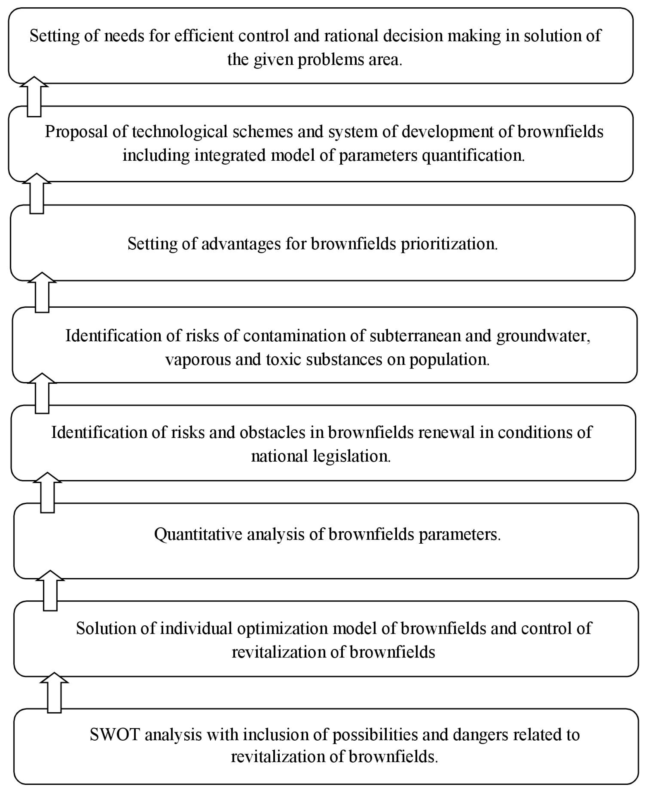
2. Methodology for Revitalization and Prioritization of Brownfields

The existing approaches to the analysis of brownfield face with difficulties in assessing their real condition. This makes it difficult to choose adequately the way to their revival—reuse, replacement of the dominant industry, conversion to the tourism zone, etc. Therefore, the additional costs of eliminating toxic wastes, reclamation and infrastructure modernization are regarded by business and local authorities as uncompetitive.
By renewal of brownfields, data about the level of land contamination are missing and the potential fines and other liabilities cannot be evaluated [9]. Risks by renewal of brownfields can be qualitatively set, but they cannot be financially quantified [11,13,14,15,16]. Investors cannot assess real revenue of such investments and, therefore, they are afraid of using brownfields and they prefer to build on a “green field” [17,18].
There is a very big difference in possibilities and approaches to solution of this complex problem area. The use of brownfields can mainly strengthen vitality, efficiency and competitiveness of villages and cities and will eliminate the pressure on the agricultural land and building on greenfields [17]. Renewal of land and its use can also contribute to creation of new workplaces, strengthening of the local economy and increase the level of tax profit of the local authorities. It also means increase in realty prices and improvement in quality of living environment. Renewal of lands also brings increase in public security transport accessibility of the area and development of new activities that will support expansion and improvement in services offered in the given area [5,10].
Brownfields have considerable negative economic effects and often negative environmental influences on their surroundings. Increased risks, uncertain conditions and expenses bound with their revitalization and reuse quite often keep the private sector from active economic participation [5]. Brownfields usually demand public interference to destroy the barriers that defend their development, thus starting the process of revitalization and reuse [14,15].
Brownfields are not new realties on the market. Their origin goes back to their past. The main reason of brownfields’ occurrence is the re-structuring of economy of the state and separate regions [4]. It is one of the results of radical changes in social-and-economic structure that are characterized by movement of work forces from primary (agricultural, forestry) sector into secondary (industry and building) and today into the tertiary (business, transport, services, public management) sector of civil life [4,5].
Brownfields represent a considerable problem for further development of cities and villages as well as regions towards sustainable development. They are manifested by inconclusive legal relationships and arrangement, devastated productive and non-productive buildings and in many cases by the presence of old environmental burdens. These are represented by different toxic substances that contaminate all elements of the environment (soil, surface water, subterranean water, air, bio), but also objects [1,19]. These areas usually serve as repositories of wastes including dangerous wastes from their previous use with considerable amount of black repositories. Considerable risks are represented by the remnants of machinery and technological equipment that may contain fillings dangerous for environment and for human health [18]. The surroundings of brownfields are clearly seeable and mainly dangerous. Local and international investors do not want to enter such areas due to the high costs bound with elimination of all environmental burdens and high investment preparation of such lands [1,2].
Brownfields are also an urban problem. Their state is also a considerable aesthetic defect in the structure of inhabitation and they also have their impacts on surroundings [14,17]. By transformation of such areas, high savings could be made in demands for building on new free lands that would support achievable permanent development. Revitalization of brownfields is usually bound with reconstruction of an unused object for a new use. If technical state of such object does not permit its reconstruction, two basic phases can occur: the phase of re-cultivation and the phase of renewal [9]. The phase of re-cultivation consists of cleaning of the land and renewal of the state similar to a greenfield and the state of renewal consists of inclusion of the locality to its efficient use.
Due to all mentioned reasons for individual cities and villages it is necessary to realize the problematics of their own brownfields, they should also highlight them in the process of land documentation and engage in formal and informal support of revitalization and reuse of such areas in a way where private sector would participate in their rehabilitation [3].
The search for new forms of obtaining information about the real condition of the brownfields is especially important for mining clusters, seeking to diversify the economy, recreate agriculture, and improve the environment.
Brownfields appear in political agenda of not only well-developed but also developing countries and at present it is bound with the idea of sustainable development. Revitalization of brownfields and their reuse will strengthen vitality, output, and competitiveness of regions and will eliminate pressure on agricultural land. To start the revitalization of brownfields areas it has to be publicly propagated and later a model of parameter quantification of brownfields should be developed that would supply all accessible information in a clear and brief manner about the existing brownfields, so they could be revitalized and according to their type—reused [13,14].
Thus, we believe it is important to formalize the sequence of actions for assessing the real state of brownfield, identify technologies for its modernization, support investments, and take necessary environmental measures.

2.1. Main Aims of the Proposal

Presently in Slovakia, there is neither evidence of brownfields and their parameters nor a system of evaluation of their risks; therefore it is necessary to design a methodology of prioritization of brownfields revitalization with the aim to create an optimization model. This methodology is applicable in Russia where during economic reforms several mining regions of Siberia, Arctic, Urals and Far East decreased and even stopped natural resources extraction. Their cities and districts became abandoned and social-and-economic problems arose. Nevertheless, in many cases it is possible to revitalize the brownfields in mining areas by changing the method of mining or conducting post-mining operations [15].
Thereby the aim of proposal is an optimization model of quantification of parameters of brownfields specific for Eastern and Central Europe, the Russian Federation. The proposed model is based on the survey of old mining clusters in Slovak Republic and Western Siberia (Russian Federation) [4,5,6,16,17,18].
The proposed optimization model came from accessible relevant data about brownfields that are affected by previous use; they have real or expected problems with contamination and need intervention so they could be returned towards efficient use. The uniqueness of the model lies in prioritization of revitalization of brownfields according to the set of quantitative parameters.
The proposed model should contribute to expansion of European experience and create forums for research and solution of brownfields problems specific for Eastern and Central Europe.
The separate phases of the proposal will be aimed at:
  • Evaluation of the actual state of brownfields from the legislative, economic and environmental point of view.
  • Design, vision, mission and strategic aims of brownfields revitalization.
  • Design of optimization model of quantification parameters of brownfields revitalization.
  • Development of strategic alternatives of brownfields revitalization.
The aims of revitalization can be divided into middle- and long-terms.
Middle-term aims:
  • Revitalization of brownfields for future industrial and non-industrial use;
  • Development of educational system in the area of brownfields revitalization and securing of professionalization of public administration within this area;
  • Maximal inclusion of accessible European resources for revitalization of brownfields.
Long-term aims:
  • Systematic problem solution for the highest number of brownfields;
  • Decrease in brownfields number and taking of agricultural land for new building in accordance with principles of permanently sustainable development;
  • Prevention of creation of brownfields;
  • Increase in quality of urban environment and increase of competitiveness of cities and villages;
  • Aimed and efficient use of public means for support of brownfields revitalization, where the public action is needed and reasonable;
  • Implementation of application of the best work by realization of projects of revitalization of brownfields, support of professional control of revitalization;
  • Increase in quality of living environment and removal of old ecological burdens in brownfields localities.
During the economic crisis, it is very important for the organizations to invest to the brownfield, pay attention to crisis management, risk management, and especially to effective risks control. In particular, the investment-intensive businesses are now exposed to the negative impact of the ongoing crisis, which brings them to financial risk. Its management requires eliminating any existing financial risks or minimizing them. The aim of output will be a model showing the danger and its degree because of modeling of investment and rate. Modeling gives the opportunity to determine the threat level and the ratio of own/foreign resources and subsequently the amount of investment and interest rates, by which the company can avoid loan, interest rate, and price risks’ threat. Moreover, the methodology will be described in the output and will be displayed as an algorithm. The whole methodology will be based on financial mathematics, which forms the basis of modeling in the time of cash flow variable value, current investment value and internal rate of investment return.
Thus, the economic assessment of a brownfield project or setting the limit of the economic efficiency of a business requires a large amount of information that must be processed in one place using one system.

2.2. Implementation of Methodology

The proposed methodological approaches used to obtain scientific results come from the used methodology in the given area.
The main reason of proposal of the optimization model is systematic control of the revitalization process of brownfields, in case of unused and old areas and in case of unused and devastated object.
It is necessary to divide the observed brownfields according to their development potential taking in account: contamination, probably uncontaminated or very contaminated, localization, good or bad localization, mining zones number. The algorithm of brownfields methodology implication consists of eight steps (Figure 1).

2.3. The Results of Proposed Methodology

The result of the research will be the creation of optimization model by which parameters of brownfields will be quantified and at the same time working out of methodology aimed at prioritization of brownfields revitalization.
The proposed optimization model of brownfields parameters quantification is aimed at creation of a national strategy for revitalization of brownfields, which is one of the aims of European Union. The model and working out of methodology of prioritization of brownfields revitalization will serve for the needs of public administration authorities, mainly the Ministry of Economy and administration as an information ground for the needs of efficient control and rational decision making in solution of the given problems area and setting of prioritization of revitalization and investments. Thanks to the proposed model, it will be possible to assess individual brownfields. By evaluation of the gathered and analyzed data, it will be possible to identify the scope and type of problems that prevent reuse of the given object and to set priorities and aims in the process of revitalization and reuse of brownfields. The basic priority lies in an appropriate identification of localities that have the highest chance to succeed on the market, as they meet the requirements of investment and to provide time, money, and public support for them.
The main advantages and expected impacts of the proposed model of brownfield solution are the following:
  • Improvement in business environment;
  • Aimed and efficient use of accessible financial resources;
  • Mobilization of private capital and obtaining multiplication effects; and
  • Expansion of special knowledge and exchanging of international practice and education support.
Regeneration of brownfields brings a row of positive effects for society and at the same time, it defends against dangers resulting from conservation of their state. There are short-term positive impacts and indirect impacts that will manifest themselves only in future.
The advantages should mainly lie in:
  • Decrease in number of brownfields and taking of agricultural land for building on green fields;
  • Evaluation of realty on the areas of brownfields and their surroundings;
  • Improvement in the living environment by removal of old ecological burdens;
  • Increase in cities attractiveness and increase in travel business;
  • Creation of new jobs;
  • Increase of economic activities in the regenerated area - business and competitiveness;
  • Inflow of direct international investments;
  • Progressive lowering of regional disparities; and
  • Better image of the Slovak republic.
In the process of brownfields revitalization there are barriers and risks that slow it considerably. The process of revitalization can be successful only after the removal of barriers. Except the financial issues, there are aspects of national, regional and local level. These main barriers are:
  • Absence of national coordination unit;
  • Poor coordination of activities between individual ministries;
  • Insufficient cooperation on the vertical level; and
  • Insufficient cooperation between separate institutions and their offices.
Finally, yet importantly, there are barriers in politics and tools influencing the given problematics:
  • Absence of national strategy to approach this problem area;
  • Absence of a unified register of localities and their critical parameters;
  • Absence of analytic tools and approaches for setting of priority investments into localities; and
  • No flexible planning tools;
  • Insufficient financial resources;
  • Obstacles in cooperation of the public and private sector.

2.4. Environmental Insurance as a New Tool and Its Contribution

Environmental insurance can play the role in stimulating accelerated redevelopment of urban brownfield sites. There will be special emphasis on pooled environmental insurance, which is a form of group insurance.
Primary findings include the following:
  • Environmental insurance (EI) has the potential to reduce the uncertainties associated with brownfield redevelopment projects. EI policies that limit clean-up cost exposures provide a strong basis for the quantification of risk that is often demanded by lending institutions as a condition for investment [16].
  • Private sector demand for EI is growing rapidly in the European Union, and speculative redevelopment of even heavily contaminated sites is now being undertaken by venture capital pools using the insurance coverage as a risk management and loss prevention tool [17].
  • While public sector experience is limited, there are some examples of creative use of environmental insurance coverage by municipalities and states to stimulate brownfield redevelopment and reuse [3].
Recommended actions for local development organizations may derive from these findings, specifically:
  • Municipal governments and other local economic and community development organizations can promote urban redevelopment on difficult-to-regenerate small sites through their ability to create pools of potential projects that could be covered by a common environmental insurance policy [1].
  • Municipal governments and other local economic and community development organizations could make a significant contribution to more systematic examination of environmental insurance and its potential value as an urban redevelopment tool through increasing local public sector awareness of the changes in EI products, services, availability and costs [18]. The Department could develop the capacity to provide the information needed by utilizing its extensive communications with local governments and agencies that apply for and/or receive grants for their urban redevelopment efforts [19].
Key issues to be addressed should include the following testable relationships between the value of environmental insurance and other factors affecting brownfield viability [18]:
  • How does municipality or metropolitan area size affect the value that insurance can provide to brownfield sites?
  • Does environment insurance make a difference by providing access to capital that would not otherwise be available?
  • How does the role of environmental insurance change with the strength of the local mineral resource market?
If local government could provide municipalities with answers to the questions, the capacity to make economic efficient decisions on the use of environmental insurance as a tool for subsidizing private redevelopment of urban brownfields would grow [18,19].

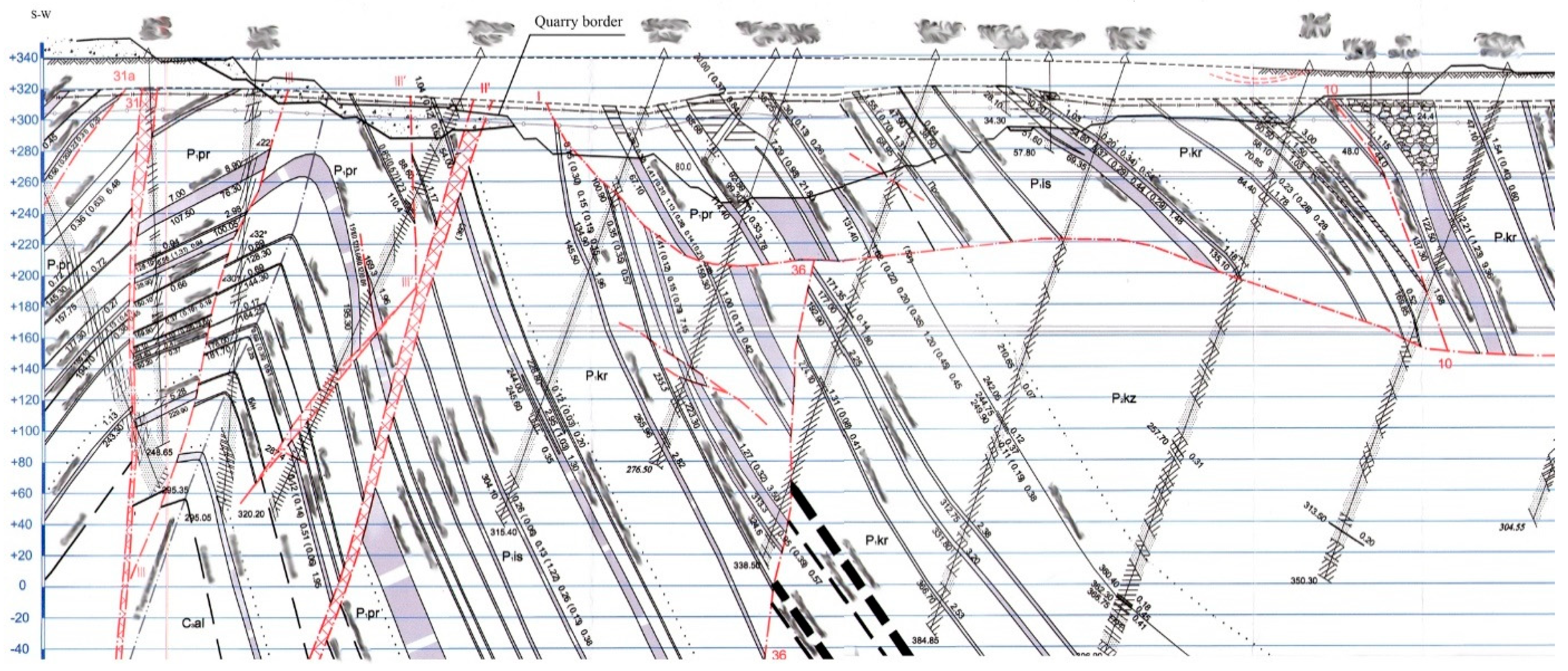
3. Case Study: Kuzbass Coal Mining

Brownfields are a potential source of problems but also a source of opportunities for future use. Quantification is therefore very important. Its completeness and balance, and its value, is very important for proper future use, so it is very important to identify the impact of brownfields on human perception and the quantification of impacts from the perspective of the population. Therefore, it is necessary to create a tool for transferring the influence parameters after the mining activity to human perception.
An example of the application of proposed methodology is the Questionnaire jointly developed and implemented by Russian and Slovak mining scientists (Table 1), used in the revitalization of the coal mining brownfield in Kuzbass (Kemerovo region, Western Siberia, Russia). This brownfield is formed in the place of several closed coal mines located contiguously near Kiselevsk—the city in the center of Kuzbass, developed in 1930–1990. The volume of coal mined for this period exceeded 250 million tons. Today these mine fields are conserved, due to the connection with the rise in the cost of underground coal mining in complicated mining-geological and hydrological conditions. The fields of different mines are located closely together and one over another, which causes a significant risk of rock bump, methane emissions, and flooding of mine workings.
The complexity of the geological conditions of the brownfield is confirmed by the profile section (Figure 2). The most part of coal from the seams on this Profile (colored grey) was previously extracted by underground mines, which are conserved now.
Today this brownfield is revitalized by Kiselevsk City Coal Open Pit Mine, which works out the pillars of conserved underground mines. Shadowing of the seams’ names on Figure 2 and the company’s specifications are due to the proprietary rights for the project data, owned by the Kiselevsk City Coal Company (Kiselevsk City, Russian Federation).
Projecting the revitalization of the Kiselevsk City coalmines’ brownfield, we followed the steps of methodological approach presented in Figure 1.
The first step is a SWOT (Strengths-Weaknesses-Opportunities-Threats) analysis of brownfield revitalization, presented in Table 2.
The second step is creating individual optimization model of brownfield’s revitalization. The research jointly performed by Slovakian (Technical University of Kosice, Faculty of Mining) and Russian (National Research Tomsk Polytechnic University and T.F. Gorbachev Kuzbass State Technical University, Mining Institute) allowed to conclude that the land of the brownfield disturbed by underground coal mining is not suitable for urban, agricultural or other industrial activity [6]. However, unmined part of valuable metallurgical coal deposit within Kiselevsk brownfield is estimated as 40 million tons that predetermined optimal model of the brownfield revitalization as changing the method of mining to surface one.
The third step is the quantitative analysis of brownfield parameters. The parameters of Kiselevsk City quarry field are the following: 3.1 km of the width, 5.1 km of the length, 90 m of currant depth (projected depth is 400 m). Current annual capacity is 2.2 million tons; the overburden ratio is 14.9 m3/ton.
The method of the quarry field mining is longitudinal double-sited. Preparation of rocks for excavation is performed by drilling-and-blasting operations. Excavation of disintegrated rock mass and coal is carried out by excavators of the type ECG, ESH (rope shovels and dragline made in Russia), hydraulic backhoes Komatsu PC1250-7, Volvo EC700, Hyundai 500LC-7. Transportation of rock mass is carried out by BelAZ 7547 and 7555V type dump trucks and their modifications and analogues. CAT D9R bulldozers are used on external and internal dumps, on the site of reclamation, for cleaning the sites under the excavators and blocks for drilling and blasting.
The fourth and fifth steps include identification of risks and obstacles of the brownfield renewal considering national legislation.
We defined the risks associated with the development of coal mining in the brownfield boundaries as the following.
First, the reduction in stability and the danger of benches collapse caused by the deepening of open pit mining to the level of underground mine workings that were not properly filled with overburden at the time of conservation. The solution of this problem requires the active use of geoscanning with a proactive identification of the natural and technogenic disruptions and landslides in the rock array.
Secondly, an increase in the inflow of groundwater contaminated with leachate products into the mine field. This problem can be successfully solved by construction of artificial filtering arrays at the quarry site, allowing clearing the quarry water to the level of Maximum Permeated Concentration (MPC) for the majority of pollutants.
The construction scheme of the artificial filtering facility on Kiselevsk brownfield (Kiselevsk City Coal Open Pit Mine) is shown on Figure 3. This filtering array was dumped of overburden on the rock bed. Considering the prominence, the place of array’s initiation was chosen straightforwardly to the narrow. It allows avoiding the impermeable levee dumping and gives favorable opportunity to construct this filter as soon as possible.
Constructing the artificial filter array on the brownfield allows sufficiently decrease discharging wastewater coming from conserved mines into the river. The wastewater comes to the Kiselevsk City Coal open pit mine workings, and then it injects to the receiver for contaminated water and flows through the filtering array under the action of gravity. The results of brownfield wastewater purifying are shown in Table 3.
According to the Table 3 data, efficiency of water filtering array working on Kiselevsk City Coal open pit mine is proved by decreasing the concentration less than MPC for major pollutants: for petroleum products—by 28 times, suspended solids—by 25 times, nitrates—by 40 times, sulfates—by five times, and chlorides—by four times. It actually proves the ecological effect of Kiselevsk brownfield revitalization by initiating open pit mining over the field of closed mines.
The sixth step means setting of advantages for brownfield prioritization, which were defined for the Kiselevsk case as the benefits of open pit coal mine presented in the following way:
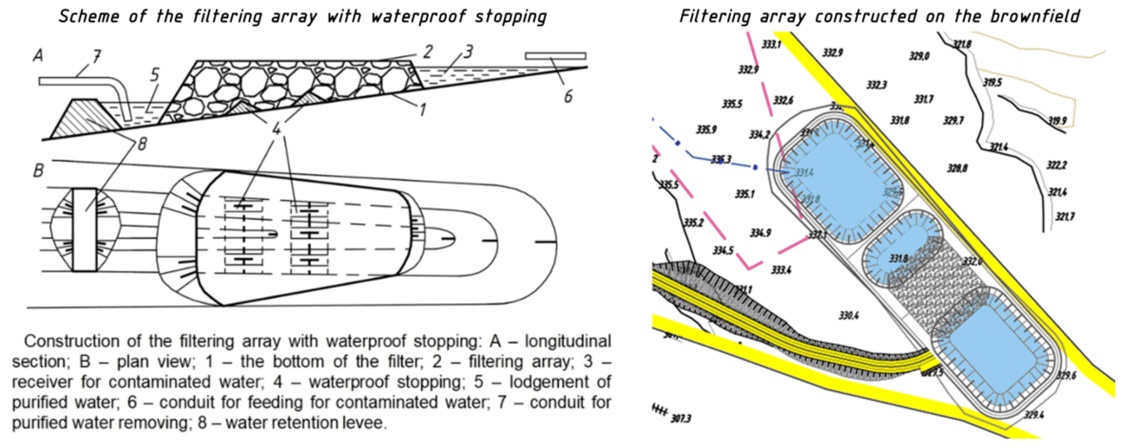
  • Ecological advantages: the return of deposit segment to exploitation without involvement of additional land; restoration of the drainage and wastewater purifying, which prevents further contamination of local rivers by products of leaching.
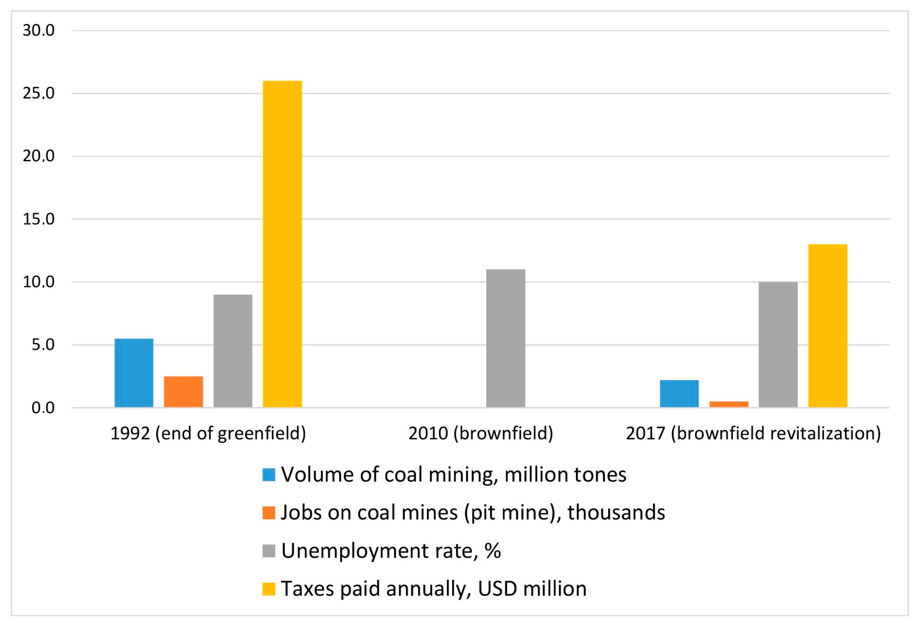
  • Economic advantages: the maintenance of mining activity in the district. If before the 1990s in this brownfield there were five mines with more than 9000 employees (of which more than 6000 were underground workers), then by the time of mines ”closure (late 1990s)” about 2500 people (1600 underground workers). In the event of a complete cessation of coal mining in the area all of them would be fired. Therefore, the construction of coal open pit mine on the site of brownfield allowed saving 580 jobs, 410 of which were occupied by former workers of closed underground mines (Figure 4).
At the same time, the tax effect from maintaining the mining operations on the brownfield is very important, because the open pit mine built in the brownfields ensures the flood of money to the local and state budget. Revitalization of Kiselevsk brownfield brought 13 million dollars taxes every year.
3.
Perspective development: the transition from underground coal mining to open pit mining ensures safer mining operations and virtually eliminates fatal accidents.
The seventh step means drawing the technological schemes for brownfield development. Since the quarry field development on Kiselevsk brownfield includes mining the coal-bearing zone with highly valuable metallurgical coal, its extraction is conducted by hydraulic excavators Komatsu PC1250-7 (Komatsu Group, Tokyo, Japan), Volvo EC700 (Volvo Construction Equipment, Brussels, Belgium), Hyundai 500LC-7 (Hyundai Heavy Industries, Ulsan, Dong District, South Korea). It opens up new opportunities for reducing coal losses and better planning of mining operations in coal-bearing area during the development of rock-and-coal blocks [20,21,22]. Processing the layers with a simple structure is carried out with the classic types of faces: sidereal and frontal (lateral) [23]. The fact is that the autonomy of hydraulic backhoe and dump truck basically allows processing the entire layer in the complex face with the implementation the crosswise (Figure 5a) and shuttle-like (Figure 5b) moves by the excavator.
The implementation of technological schemes for using hydraulic backhoes for excavation of coal at the open pit mine built on the Kiselevsk brownfield has unquestionable advantages over shovels due to high autonomy and maneuverability of the backhoe, the possibility of flexible usage of trucks for rock mass transportation.
The eighth step is establishing control and decision making system for future development of given brownfield. We plan to develop the strategy of the Kuzbass coal mining brownfields’ revitalization at the next stage of our research.

4. Conclusions

The given research of the brownfield methodology can be summarized in the main findings that include the following: the proposed approach to brownfield estimation and adaptation of environmental insurance to specific conditions of reducing the economic damage from continuing industrial use of recently abandoned areas; the sequence of steps of this approach implementation in a certain area, including the questionnaire for information of brownfield assessment; the practical suggestions for complete mineral resource extraction within the brownfield with improving environmental and economic conditions.
We believe that the revitalization of brownfield in old coal clusters may not always mean a complete cessation of mineral resources extraction. To confirm this, we demonstrated the experience of revitalization of the Kiselevsky coal mining brownfield in Kuzbass (Western Siberia, Russia), associated with the conservation of coal mines for economic reasons, proved the efficiency of the construction of a coal open pit mine that develops a coal-bearing zone. The construction of a new enterprise on previously conserved mine fields has made it possible not only to attract investments in the municipal economy, create new jobs and obtain tax revenues, but also to build facilities for purifying contaminated water from mine and quarry fields—the artificial filtering array. As a result, the hypothesis that the revitalization of the brownfield brings not only a positive social-and-economic, but also an environmental effect was confirmed, which is especially important for the old industrial mining areas.
We believe that the further development of the Brownfield methodology will offer the universal measures for the brownfields of different origin (mining, chemical, and waste landfill).

Author Contributions

Conceptualization: M.C. and J.J.; methodology: Z.Š.; formal analysis: T.P.; investigation: M.G.; resources: M.T. and S.Z.; data curation: Z.Š. and T.P.; writing—original draft preparation: M.C.; writing—review and editing: J.J.; visualization: M.T. and S.Z.; supervision: J.J.; project administration: M.C.

Funding

This research received no external funding.

Acknowledgments

The research is supported by Tomsk Polytechnic University under the Tomsk Polytechnic University Competitiveness Enhancement Program grant.

Conflicts of Interest

The authors declare no conflict of interest.

References

  1. Cehlár, M.; Šimková, Z. State of Approaches to Evaluation of Mineral Deposits. Econ. Innov. Manag. 2017, 52–65. [Google Scholar] [CrossRef]
  2. Pavolová, H.; Cehlár, M.; Soušek, R. Vplyv Antropogénnych Činností na Kvalitu Životného Prostredia; Institut Jana Pernera: Pardubice, Czech Republic, 2012. (In Slovak) [Google Scholar]
  3. Pavolová, H.; Domaracká, L.; Mitterpachová, N. The Impact of Environmental Burden on the Reuse of Brownfields in Slovakia; Univerisities of Košice Publishing: Košice, Slovakia, 2009. [Google Scholar]
  4. Gasanov, E.A.; Gasanov, M.A. Innovative Development of Russian Arctic. Econ. Innov. Manag. 2017, 30–38. [Google Scholar] [CrossRef]
  5. Golofastova, N.N.; Mikhailov, V.G.; Seredyuk, I.V. Transformation of ecological-economic system of coal mining region. Econ. Innov. Manag. 2017, 66–75. [Google Scholar] [CrossRef]
  6. Litvin, O.; Tyulenev, M.; Zhironkin, S.; Prokopenko, S. Methodology of coal losses calculation at open pit mining for complex geological conditions—Review. Acta Montan. Slov. 2017, 22, 146–152. [Google Scholar]
  7. Banzhaf, S.; McCormick, E. Moving beyond Cleanup: Identifying the Crucibles of Environmental Gentrification; National Center for Environmental Economics: Washington, DC, USA, 2007. Available online: https://www.epa.gov/environmental-economics/working-paper-moving-beyond-cleanup-identifying-crucibles-environmental (accessed on 10 October 2018).
  8. Environmental Protection Agency (EPA). Brownfields Assessment Grants FactSheet; Environmental Protection Agency: Washington, DC, USA, 2009. [Google Scholar]
  9. Hollander, J.; Kirkwood, N.; Gold, J. Principles of Brownfield Regeneration: Cleanup, Design, and Reuse of Derelict Land; Island Press: Washington, DC, USA, 2010. [Google Scholar]
  10. Fisher, B.H. Brownfields Redevelopment and Gentrification: A Socio-Economic Evaluation of the EPA Brownfields Pilot Program; Iowa State University: Ames, IA, USA, 2011. [Google Scholar]
  11. Holmanová, A. Brownfields in the Rural Landscape; Land Plans: Kosice, Slovakia, 2017; Available online: http://www.uzemneplany.sk/zakon/brownfieldy-vo-vidieckej-krajine (accessed on 10 October 2018).
  12. Ferber, U. Brownfields Handbook, Lifelong Educational Project on Brownfields; Tech. Rep. Leonardo Da Vinci Pilot Project CZ /04/B/F/PP-168014; Silezian University: Gliwice, Poland, 2006. [Google Scholar]
  13. U.S. EPA (United States Environmental Protection Agency). Potential Insurance Products for Brownfields; U.S. EPA: Washington, DC, USA, 1996.
  14. Walker, C.; Boxall, P.; Bartsch, C.; Collaton, E.; Meyer, P.B.; Yount, K.R. The Impact of Environmental Hazards and Regulations on Urban Redevelopment; Northern Kentucky University: Washington, DC, USA, 1997. [Google Scholar]
  15. Kretschmann, J.; Efremenkov, A.B.; Khoreshok, A.A. From Mining to Post-Mining: The Sustainable Development Strategy of the German Hard Coal Mining Industry; IOP Conf. Series: Earth and Environmental Science; IOP Publishing: Bristol, UK, 2017; Volume 50, p. 012024. [Google Scholar]
  16. Cehlár, M.; Domaracká, L.; Šimko, I.; Puzder, M. Mineral Resource Extraction and Its Political Risks; Environmental Science, Policy and Management (ESPM) Workshop: Tatranská Štrba, Slovak, 2015. [Google Scholar]
  17. Pavolová, H.; Domaracká, L.; Mitterpachová, N. The Impact of Environmental Burden on the Reuse of Brownfields in Slovakia, 2nd ed.; Univerisities of Košice Publishing: Košice, Slovakia, 2015. [Google Scholar]
  18. Cehlár, M.; Kuzevic, S. Environmental Insurance for Brownfields Redevelopment Activities and Feasibility Study as Basic Part of Complex Solution. Acta Montan. Slov. 2004, 9, 5–8. [Google Scholar]
  19. Cehlar, M.; Vodzinsky, V. New Approach to the Basic Evaluation of Raw Material Resources in Market Economy. Acta Montan. Slov. 2001, 6, 42–55. [Google Scholar]
  20. Tyulenev, M.A.; Zhironkin, S.A.; Litvin, O.I.; Tyuleneva, E.A.; Zhironkina, O.V.; Markov, S.O. Safe and Productive Application of Hydraulic Backhoes in Coal-Bearing Areas of Complex Structured Deposits. Geotech. Geol. Eng. 2017, 35, 2065–2077. [Google Scholar] [CrossRef]
  21. Vaneev, A.V. Opening-Up Scheme with Transport Jumpers to Reduce the Overburden and Coal Transportation Distance at Arshanovsky Open Pit: Case Study. J. Min. Geotech. Eng. 2018, 2, 13–35. [Google Scholar] [CrossRef]
  22. Kolesnikov, V.F.; Cehlar, M.; Tyuleneva, E. Overview of excavation and loading operations in the coal-bearing zones at Kuzbass open pit mines. J. Min. Geotech. Eng. 2018, 2, 36–49. [Google Scholar] [CrossRef]
  23. Katsubin, A.V.; Makridin, E.V. Systematization of the technological schemes of excavator faces at the central Kuzbass open pit mines. J. Min. Geotech. Eng. 2018, 1, 81–88. [Google Scholar] [CrossRef]
Figure 1. The sequence of steps of proposed methodological approaches used to obtain scientific results come from the used methodology in the given area.
Resources 08 00021 g001
Figure 2. Profile section of the Kiselevsk brownfield with the new quarry field borders.
Resources 08 00021 g002
Figure 3. Construction of the filtering array at the Kiselevsk City Coal open pit mine.
Resources 08 00021 g003
Figure 4. Economic indicators of the Kiselevsk brownfield revitalization.
Resources 08 00021 g004
Figure 5. Technological scheme of heterogeneous layers development at Kiselevsk City Coal open pit mine: (a) separate excavation by simple face on rock-and-coal panel; and (b) complex face. m—the seam capacity; Wtrench—the width of the working trench; hl—the layer’s height; Rdu—the radius of scooping; Rtr—the radius of dump truck turning; lb—the length of the coal block being excavated.
Resources 08 00021 g005
Table 1. Questionnaire for information of brownfield assessment.
Basic DataSettingsCase Described
Town (city) Kiselevsk City
District Kemerovo region
County Russia
Total population of municipality (city) 91,000
Area of municipality (city) in m2 162,000,000
Population density at 1 m2 0.0006
Movement of the populationPopulation growth-
Stagnant population-
Population decline−13,000 for 2007–2017
The relation of the municipality to the main transport infrastructure (distance in km)Highway-
Way of 1st class14
Main railway line1
Airport25
Facilities of the villageElectricityYes
GasYes
WaterYes
CanalizationYes
Socio-economic situation of the municipality
Indicator of the debt of the municipality (city)High (>35%)-
Medium (15–35%)Yes
Low (<15%)-
Registered unemployment rate in %In the town (in the town)11
In the district8
In the county6.2
Structure of population (city) in %Pre-productive age17
Productive age21
Post-productive age62
Indicators of the total utilization of the territory of the municipality
State of the planning documentationNegotiated and approved in the year-
Updating (end date)2011
Top Investors (Provide Name)In the town (in the town)JSC Kiselevsk City Coal Company
In the districtJSC KuzbassRazrezUgol
In the countyJSC UGMK
Basic data on brownfield
Location of brownfields
Address of location of brownfieldsCompanyKiselevsk City Coal Open Pit Mine
LocationQuarry field in 1.4 km to Kiselevsk City
Cadastral area
Area of brownfields in m2 35,400,000
Ownership structure (please include a list of owners in the annex, or contact details for the owners)State-
Community-
Domestic private owner-
Foreign private owner-
A cooperative of ownersYes
Other entity-
Unknown-
Property-legal relations (please attach: cadastral map-copies of ownership sheets)Simple ownership relationshipsYes
Multiple owners acting in concert-
Multiple owners acting unattended-
Current state of brownfield
Status of abandoned and unused brownfieldBrownfield is completely abandoned and unused-
Brownfield is partially abandoned and unusedYes
Brownfield is used inappropriately-
Current state of the brownfieldRelatively good-
BadYes
Emergency-
Brownfield equipmentElectricityYes
GasNo
WaterYes
CanalizationYes
Age brownfieldUp to 5 years-
5 to 15 years-
Over 15 yearsYes
The nature of the previous use in terms of contaminationWithout contamination-non-hazardous, mild-
Contamination-moderate riskYes
Contamination-high risk-
Identification of the brownfield site in terms of the importance of the urban or landscape elementYes/NoYes
Location of the brownfield site in the flood areaYesTechnogenic
NoNatural
Ecological audit (if yes, please specify)Yes/NoYes (water, air, seismic)
Survey of contamination (if yes, please specify)Yeswater, air pollution with suspended material, aerosols
No-
Pollution risk analysis (if yes, please specify)YesHigh for water contamination
No-
Original purpose brownfield
Brownfields categories:Industrial buildings-
Army objects-
Abandoned or inappropriately used agricultural objects-
Former quarry areas—quarries, minesYes
Former outlets or operations-
Unused land plots-
Uninhabited blocks of residential homes-
Other
Original use of brownfields—the previous industry (if the name of the business is also known)Coal mining
Table 2. The brownfield revitalization SWOT analysis.
StrengthsWeaknesses
OpportunitiesMaintaining mining activity in the area, which is widely known as high quality metallurgical coal producer.Missing the chance of regional economy deep diversification.
ThreatsTemporizing the solution of ecological problems of mining area, mainly land occupying and water pollution.Unstable inflow of investments depending on the prices on the world coal market
Table 3. Water contamination reduction after using artificial filter array at the Kiselevsk City Coal open pit mine.
Defining Ingredients (Pollutants), mg/LMaximum Permeated Concentration (MPC)Concentration of Pollutants Before PurifyingConcentration of Pollutants After Purifying (in Disposed Water)
pH6.5–8.57.57.21
Chlorides300.086.8519.1
Ammonium ion0.51.180.44
Nitrate ion40.0321.848.5
Nitrite ion0.086.420.19
Ferrum0.10.620.17
Sulfates100.0389.4276.1
Petroleum products0.053.450.13
Suspended solidsMore than 75.0 mg/L154.246.0
Dissolved oxygenMore than 4.0 mg/L4.58.5
Cuprum0.0010.0060.0012
Manganese0.010.0290.001

