
Critical Tectonic Limits for Geothermal Aquifer Use: Case Study from the East Slovakian Basin Rim


Abstract
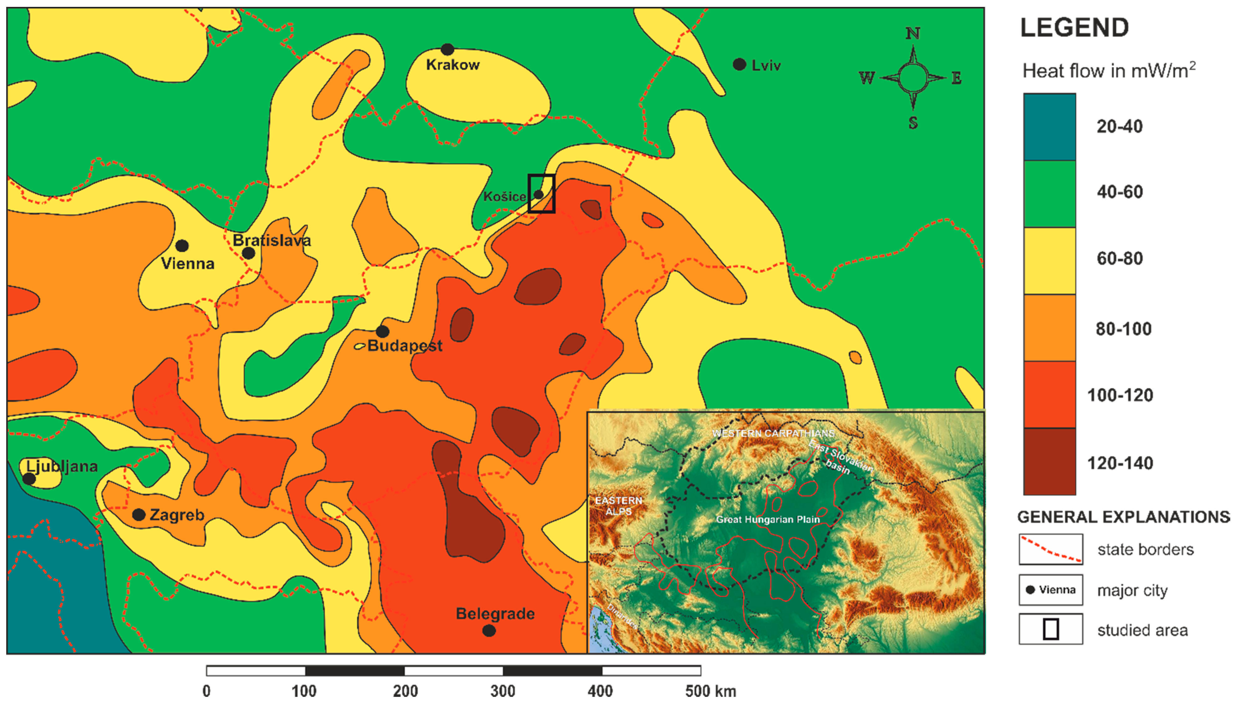
1. Introduction
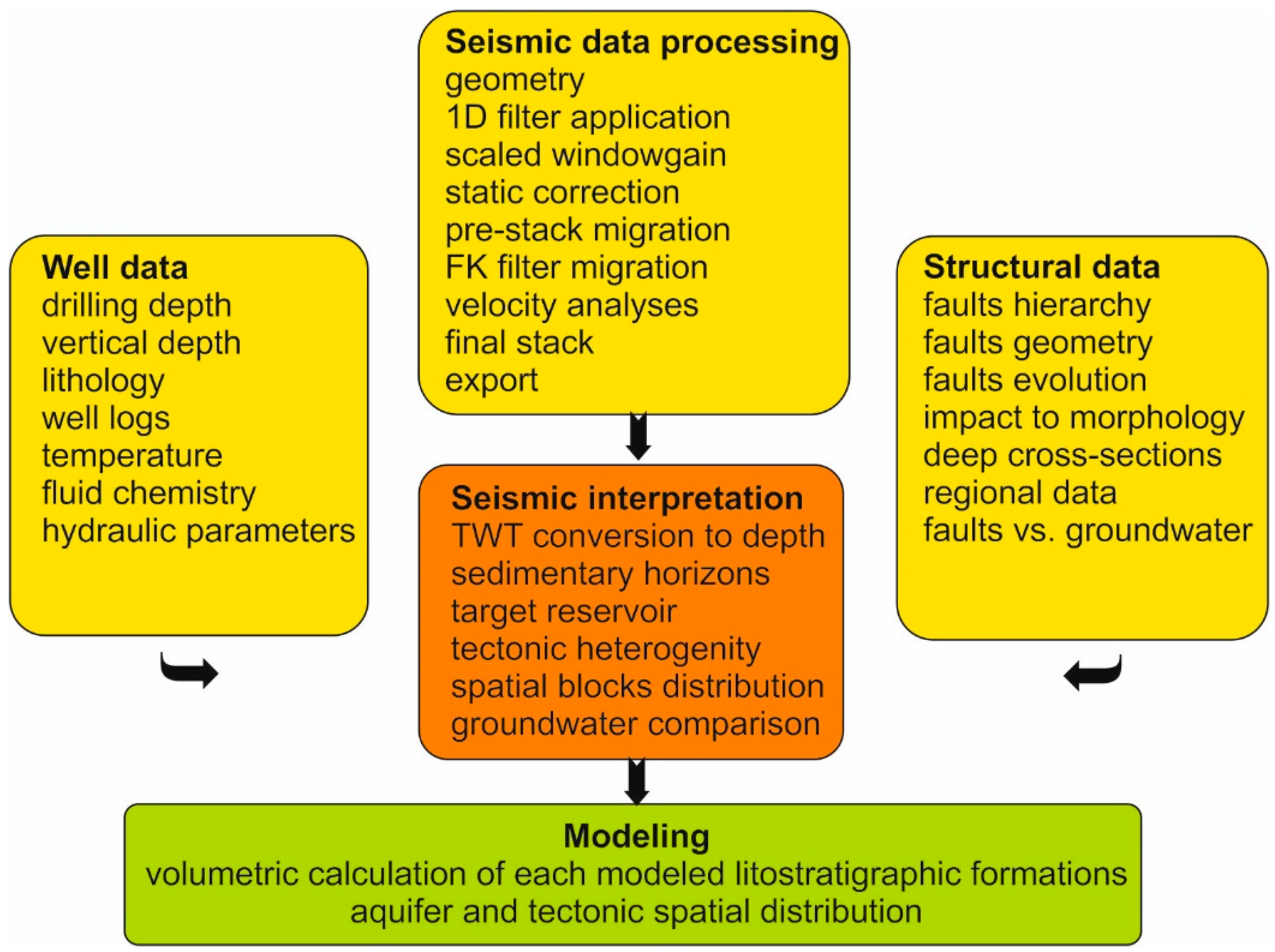
2. Materials and Methods
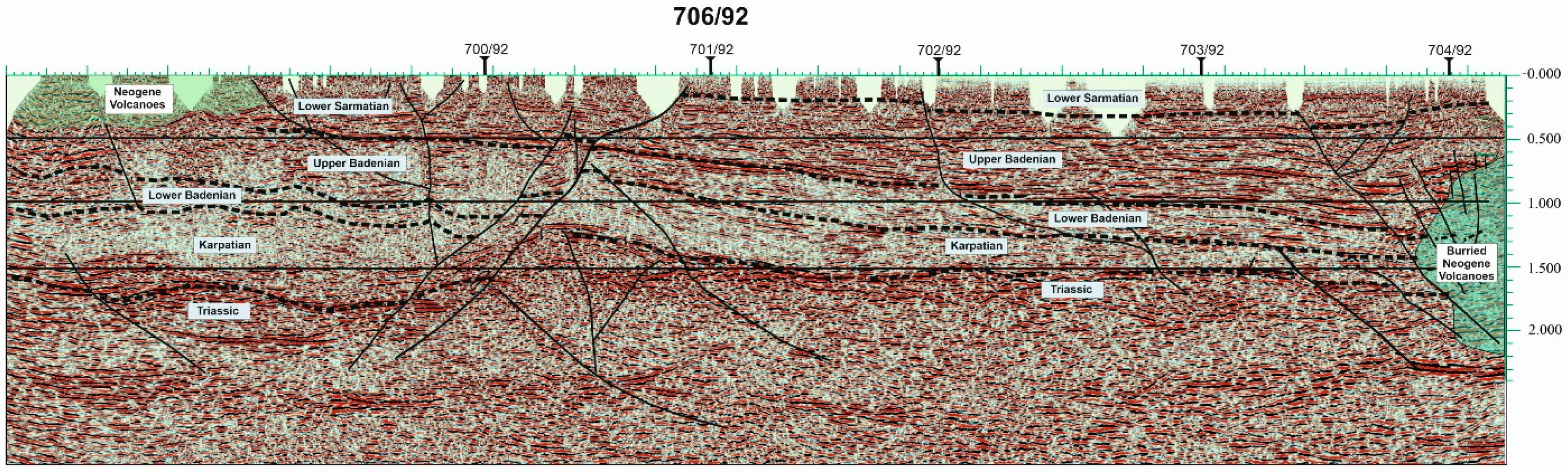
- the basal plane of Mesozoic sequences
- the interface of Mesozoic top/Karpatian formations
- the interface between Karpathian/Early-Middle Badenian formations
- Early-Middle Badenian/Late Badenian formations boundary
- Late Badenian/Sarmatian formations boundary
3. Results
3.1. Geology and Hydrogeological Conditions
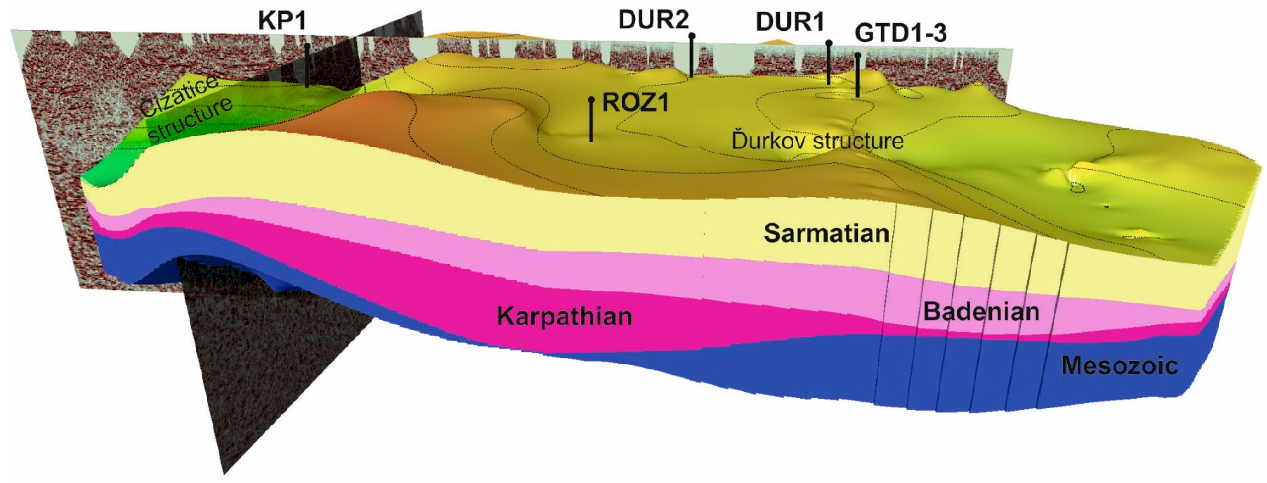
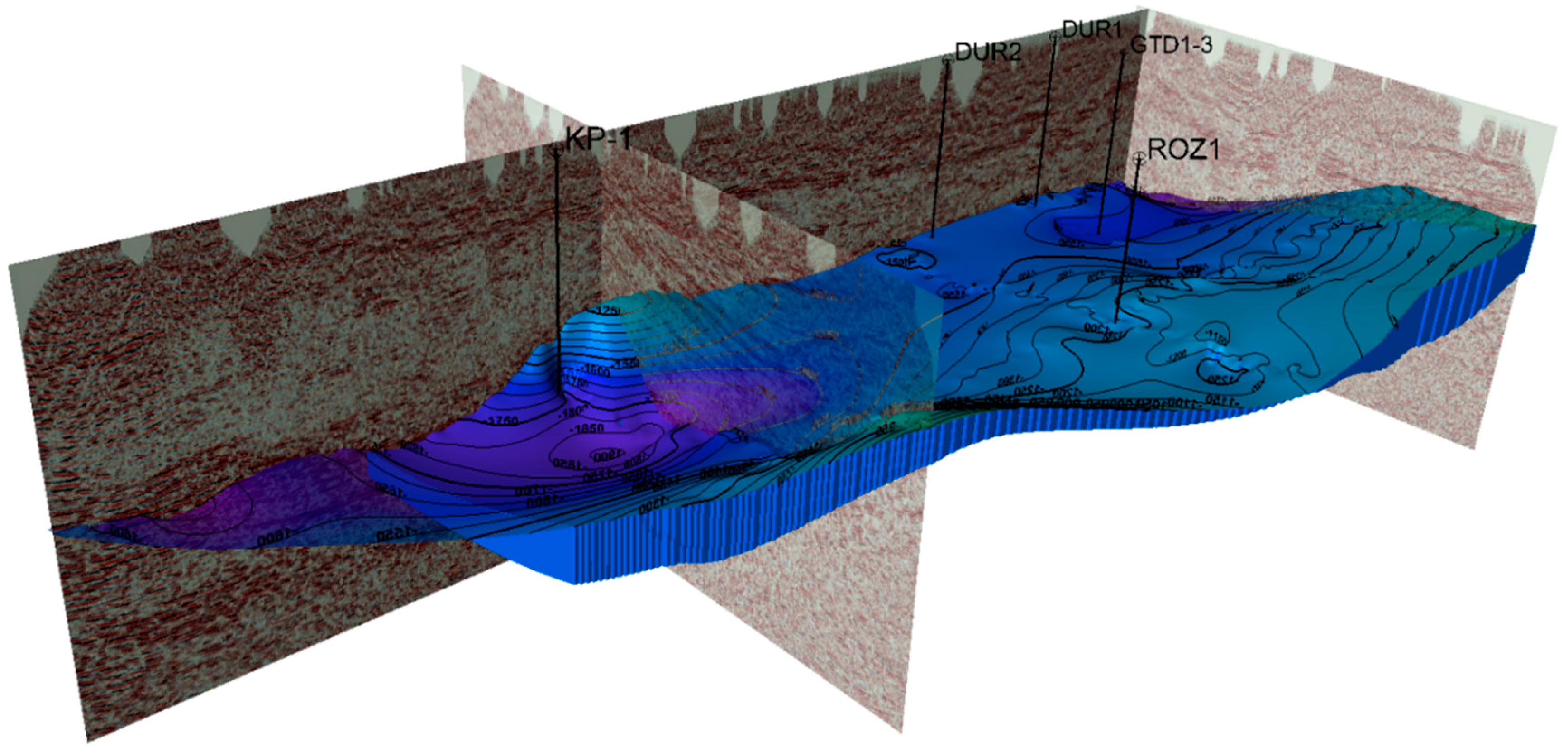
3.2. Structural Model
4. Discussion
5. Conclusions
- ▪
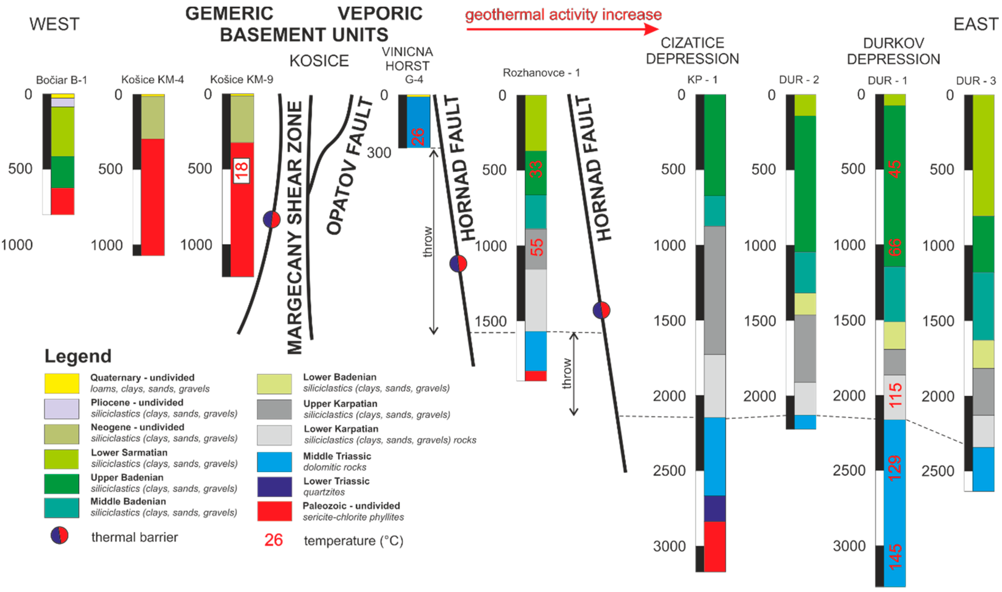
- The thickness of the Mesozoic aquifer is increasing from the west (185 m) to the east (1060 m or more). The changes of thickness relate to the tectonic thickening of layers as a consequence of the uplift of the basement units on the western edge of the East Slovakian basin.
- ▪
- The aquifer depth increase significantly from the west (0 m) to the east (2475 m) on a short distance of 20 km. The entire original horizon is subdivided into tectonic blocks with individual depth and lateral rate by the “domino” effect. The vertical subsidence of the tectonic blocks reaches 1200 m.
- ▪
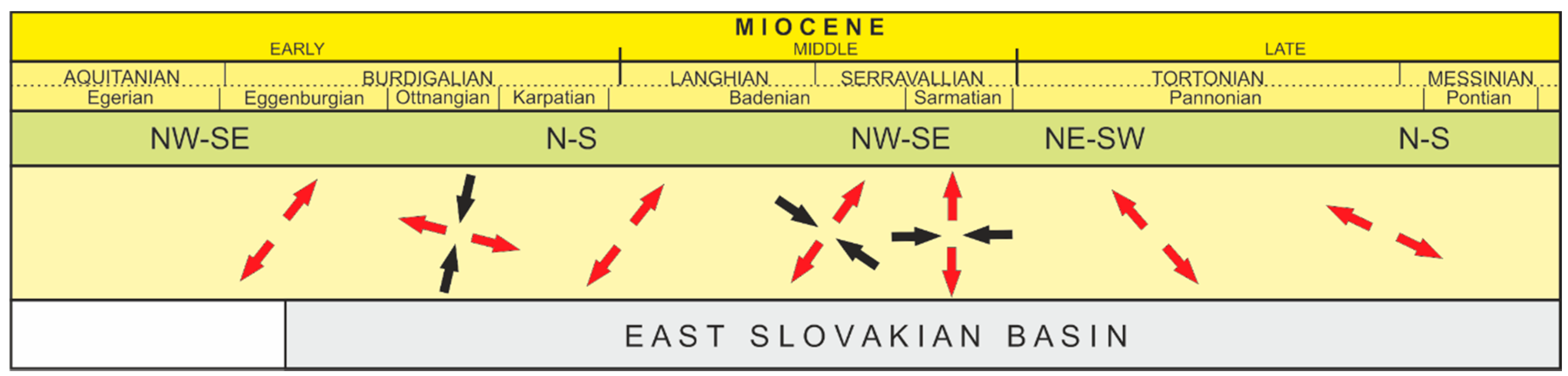
- The process of individualization of the tectonic blocks was successive. First, existing NW-SE and N-S pre-Miocene structures were preferred. Later, evolutionary younger dislocations and joints of NE-SW direction were active.
- ▪
- The flow of the thermal groundwater in the fractures is closely linked to the dilatation structures of the NE-SW direction, which enabled the migration of waters from the basin center towards its western edge. The result is warm groundwater in wells (17 °C from depth 150 m, 26 °C from depth 300 m) at the western edge of the East Slovakian basin. Common temperatures are up to 9 °C.
- ▪
- The geothermal structure contains three different chemical types of water confirmed by wells. Their spatial chemical distribution where Na-HCO3 water type and 10.9 g·L−1 mineralization (in the north), the Ca-Mg-HCO3 with 0.5–4.5 g·L−1 mineralization (in the west), and Na-Cl water type containing 20.4–33.1 g·L−1 mineralization (in the southwest), correlate with open fissure distribution.
- ▪
- Identifying critical tectonic structure is most important in the areas with a high tectonic impact on the geothermal aquifer. The future project for geothermal utilization of geothermal potential must implement all relevant datasets. The tectonics dataset is one of them.
Author Contributions
Funding
Institutional Review Board Statement
Informed Consent Statement
Conflicts of Interest
References
- Allansdottir, A.; Pellizzone, A.; Sciullo, A. Geothermal Energy and Public Engagement. In Geothermal Energy and Society. Lecture Notes in Energy; Manzella, A., Allansdottir, A., Pellizzone, A., Eds.; Springer: Cham, Switzerland, 2019; Volume 67, pp. 55–65. [Google Scholar] [CrossRef]
- Lund, J.W.; Toth, A.N. Direct utilization of geothermal energy 2020 worldwide review. Geothermics 2021, 90, 101915. [Google Scholar] [CrossRef]
- Lund, J.W.; Boyd, T.J. Direct utilization of geothermal energy 2015 worldwide review. Geothermics 2016, 60, 66–93. [Google Scholar] [CrossRef]
- Lund, J.W.; Freeston, D.H.; Boyd, T.J. Direct utilization of geothermal energy 2010 worldwide review. Geothermics 2011, 40, 159–180. [Google Scholar] [CrossRef]
- Lund, J.W.; Freeston, D.H.; Boyd, T.J. Direct applications of geothermal energy 2005 worldwide review. Geothermics 2006, 34, 691–727. [Google Scholar] [CrossRef]
- Lund, J.W.; Freeston, D.H. World-wide direct uses of geothermal energy 2000. Geothermics 2001, 30, 29–68. [Google Scholar] [CrossRef]
- Lund, J.W.; Toth, A.N. Direct utilization of geothermal energy 2020 worldwide review. In Proceedings of the World Geothermal Congress 2020, Reykjavik, Iceland, 26 April–2 May 2020; 39p. [Google Scholar]
- Erlingsson, T.; Thorhallsson, S. Long Distance Transmission Pipelines for Geothermal Waters in Iceland (20–60 km). In Proceedings of the Workshop for Decision Makers on Direct Heating Use of Geothermal Resources in Asia, organized by UNU-GTP, TBLRREM and TBGMED, Tianjin, China, 11–18 May 2008; 12p. [Google Scholar]
- Horváth, F.; Musitz, B.; Balázs, A.; Végh, A.; Uhrine, A.; Nádor, A.; Koroknai, B.; Pap, N.; Tótha, T.; Wórum, G. Evolution of the Pannonian basin and its geothermal resources. Geothermics 2015, 53, 328–352. [Google Scholar] [CrossRef]
- Dövényi, P.; Horváth, F. A review of temperature, thermal conductivity, and heat flow data from the pannonian basin. In The Pannonian Basin: A Study in Basin Evolution; Royden, L.H., Horváth, F., Eds.; AAPG Memoir 45; American Association of Petroleum Geologists: Tulsa, OK, USA, 1988; Volume 45, pp. 195–235. [Google Scholar]
- Dövényi, P.; Horváth, F.; Drahos, D. Geothermal thermic map (Hungary). In Atlas of Geothermal Resources in Europe; Hurter, S., Haenel, R., Eds.; 267. Publication No. EUR 17811; Office for Official Publications of the European Communities: Luxembourg, 2002; 267p. [Google Scholar]
- Horváth, F.; Sztanó, O.; Uhrin, A.; Fodor, L.; Balázs, A.; Kóbor, M.; Wórum, G. Towards a dynamic model for the formation of the Pannonian basin. In Proceedings of the EGU General Assembly 2012, Vienna, Austria, 22–27 April 2012; Geophysical Research Abstracts. Volume 14. [Google Scholar]
- Franko, O.; Fendek, M.; Remšík, A. Geothermal Energy of the Slovak Republic; Štátny Geologický Ústav Dionýza Štúra: Bratislava, Slovakia, 1995; 90p. [Google Scholar]
- Kováč, M.; Bielik, M.; Hók, J.; Kováč, P.; Kronone, B.; Labák, P.; Moczo, P.; Plašienka, D.; Šefara, J.; Šujan, M. Seismic activity and neoteconic evolution of the Weastern Carpathians (Slovakia). EGU Stephan Mueller Spec. Publ. Ser. 2002, 3, 167–184. [Google Scholar] [CrossRef]
- Tari, G.; Dövényi, P.; Dunkl, I.; Horváth, F.; Lenkey, L.; Stefanescu, M.; Szafian, P.; Tóth, T. Lithospheric structure of the Pannonian basin derived from seismic, gravity and geothermal data. Geol. Soc. Lond. Spec. Publ. 1999, 156, 215–250. [Google Scholar] [CrossRef]
- Jarosinski, M.; Beekman, F.; Matenco, L.; Cloetingh, S. Mechanics of basin inversion: Finite element modelling of the Pannonian Basin System. Tectonophysics 2011, 502, 196–220. [Google Scholar] [CrossRef]
- Lenkey, L.; Dövényi, P.; Horváth, F.; Cloetingh, S.A.P.L. Geothermics of the Pannonian basin and its bearing on the neotectonics. EGU Stephan Mueller Spec. Publ. Ser. 2002, 3, 29–40. [Google Scholar] [CrossRef]
- Ustaszewski, K.; Kounov, A.; Schmid, S.M.; Schaltegger, U.; Krenn, E.; Frank, W.; Fügenschuh, B. Evolution of the Adria-Europe plate boundary in the northern Dinarides: From continent-continent collision to back-arc extension. Tectonics 2010, 29, TC6017. [Google Scholar] [CrossRef]
- Ustaszewski, K.; Schmid, S.M.; Fügenschuh, B.; Tischler, M.; Kissling, E.; Spakman, W. A map-view restoration of the Alpine-Carpathian-Dinaridic system for the Early Miocene. Swiss J. Geosci. 2008, 101 (Suppl. 1), 273–294. [Google Scholar] [CrossRef]
- Kováč, M.; Kováč, P.; Marko, F.; Karoli, S.; Janočko, J. The East Slovakian Basin—A complex back-arc basin. Tectonophysics 1995, 252, 453–466. [Google Scholar] [CrossRef]
- Fričovský, B.; Černák, R.; Marcin, D.; Blanárová, V.; Benková, K.; Pelech, O.; Fordinál, K.; Bodiš, D.; Fendek, M. Geothermal energy use–country update for Slovakia. In Proceedings of the World Geothermal Congress 2020, Reykjavik, Iceland, 26 April–1 May 2020; 19p. [Google Scholar]
- Kaličiak, M.; Baňacký, V.; Janočko, J.; Karoli, S.; Petro, L.; Spišák, Z.; Vozár, J.; Žec, B. Geological Map of the Slánske vrchy Mts. and Košice Depression—South part M 1: 50,000; Lib. of the Slovak Geol. Survey: Bratislava, Slovakia, 1996. [Google Scholar]
- Pachocka, K.; Jacko, S.; Pachocki, M. 3D modeling of a Geothermal Reservoir in Eastern Slovakia Area: The Central Part of Kosice Basin; VDM Verl.: Saarbrücken, Germany, 2010; 62p. [Google Scholar]
- Beardsmore, G.R.; Cull, J.P. Thermal Conductivity In Crustal Heat Flow: A Guide to Measurement and Modelling; Beardsmore, G.R., Cull, J.P., Eds.; Cambridge University Press: New York, NY, USA, 2001; pp. 90–145. [Google Scholar] [CrossRef]
- Čverčko, J. Final Report from Pioneer Borehole Ďurkov-2; Manuscript; Lib. of the Slovak Geol. Survey: Bratislava, Slovakia, 1970; pp. 1–98. [Google Scholar]
- Čverčko, J.; Magyar, J.; Rudinec, R.; Jung, F.; Lunga, S.; Očovský, J.; Varga, M.; Mořkovský, M.; Lukášová, R. Final Report from Deep Research Well in the East Slovakian Basin; Manuscript; Lib. of the Slovak Geol. Survey: Bratislava, Slovakia, 1983; pp. 1–135. [Google Scholar]
- Rudinec, R. Sources of Oil, Gas and Geothermal Energy in the Eastern Slovakia; Alfa Lib.: Bratislava, Slovakia, 1989; pp. 1–162. [Google Scholar]
- Pereszlenyi, M.; Pereszlenyiova, A.; Masaryk, P. Geological setting of the Košice Basin in relation to geothermal energy resources. Bulletin d’Hydrogeologie 1999, 17, 115–122. [Google Scholar]
- Jacko, S.; Labant, S.; Bátorová, K.; Farkašovský, R.; Ščerbáková, B. Structural contraints of neotectonic activity in the eastern part of the Western Carpathians orogenic wedge. Quat. Int. 2020. [Google Scholar] [CrossRef]
- Jacko, S. New Upper Triassic Formations in Mesozoic of the Čierna Hora Mts. Geol. Práce 1987, Správy 87, 19–25. [Google Scholar]
- Jacko, S.; Farkasovsky, R.; Kondela, J.; Mikus, T.; Scerbakova, B.; Dirnerova, D. Boudinage arrangement tracking of hydrothermal veins in the shear zone: Example from the argentiferous Strieborna vein (Western Carpathians). J. Geosci. 2019, 64, 179–195. [Google Scholar] [CrossRef]
- Čverčko, J. The Faults of the East Slovakian Basin and Their Tectogenetic Evolution. Ph.D. Thesis, Geofond, Bratislava, Slovakia, 1977; pp. 1–143. Available online: https://www.geology.sk/sluzby/digitalny-archiv/ (accessed on 20 February 2021).
- Vass, D. The Fault System Evaluation in Košice Depression with Special View to Tahanovce and Krasna n. Hornadom Area. Final Report of Slovak Geological Survey; Geofond: Bratislava, Slovakia, 1979; 18p, Available online: https://www.geology.sk/sluzby/digitalny-archiv/ (accessed on 20 February 2021).
- Kaličiak, M.; Baňacký, V.; Janočko, J.; Karoli, S.; Petro, Ľ.; Spišák, Z.; Vozár, J.; Žec, B. Explanation to Geological map of the Slanske Mts. and Kosice Depression—Southeastern; Slovak Geological Survey: Bratislava, Slovakia, 1996; pp. 1–206. [Google Scholar]
- Jacko, S.; Janočko, J.; Jacko, S. Tectonic evolution of the southern part of the Central-Carpathian Paleogene Basin in the Eastern Slovakia. Geol. Carpathica 2002, 53, 155–156. [Google Scholar]
- Kováč, M.; Márton, E.; Oszczypko, N.; Vojtko, R.; Hók, J.; Králiková, S.; Plašienka, D.; Klučiar, T.; Hudáčková, N.; Oszczypko-Clowes, M. Neogene palaeogeography and basin evolution of the Western Carpathians, Northern Pannonian domain and adjoining areas. Glob. Planet. Chang. 2017, 155, 133–154. [Google Scholar] [CrossRef]
- Márton, E.; Vass, D.; Túnyi, I. Counterclockwise rotations of the Neogene rocks in the East Slovak Basin. Geol. Carpathica 2000, 51, 159–168. [Google Scholar]
- Jacko, S.; Farkašovský, R.; Dirnerová, D.; Kondela, J.; Rzepa, G.; Zákršmidová, B. The Late Cretaceous conditions of the Gom-515 basek beds sedimentation (Silica nappe, Western Carpathians). Acta Montan. Slovaca 2016, 21, 259–271. [Google Scholar]
- Jacko, S.; Fričovský, B.; Pachocká, K.; Vranovská, A. Stationary reverse temperature modeling and geothermal resources callibration for the Košice depression (Eastern Slovakia). Technika poszukiwań geologicznych: Geotermia, Zrównowazony rozvój 2014, 53, 3–25. [Google Scholar]
- Fričovský, B.; Jacko, S.; Popovičová, M.; Tometz, L. Substitution Approach in Carbon Dioxide Emission Reduction Evaluation: Case Study on Geothermal Power Station Project Plan-Ďurkov (Košice Basin, Slovakia). Int. J. Environ. Sci. Dev. 2013, 4, 124–129. [Google Scholar] [CrossRef][Green Version]
- Rudinec, R. Interaction between Sedimentary Fill and Pro-Neogene Basement in Central Part of the Košice-Prešov Depression; Nafta Michalovce Lib.: Michalovce, Slovakia, 1973; pp. 1–75. [Google Scholar]
- Král, M.; Lizoň, I.; Janči, J. Geothermic Research in Slovakia. Final Report from 1981 to 1985; Lib. of the Slovak Geol. Survey: Bratislava, Slovakia, 1985; 116p. [Google Scholar]
- Vizi, L.; Fričovský, B.; Zlocha, M.; Surový, M. Use of Geostatistical Simulation in Reservoir Thermodynamics Assessment and Interpretation at the Ďurkov Hydrogeothermal Structure, Slovakia. Slovak Geol. Mag. 2020, 20, 85–98. [Google Scholar]
- Fričovský, B.; Jacko, S.; Chytilová, M.; Tometz, L. Geothermal energy of Slovakia-CO2 emissions reduction contribution potential (background study for conservative and non-conservative approach). Acta Montan. Slovacaca 2012, 17, 290–299. [Google Scholar]
- Bodiš, D.; Vranovská, A. Genesis of anomalous arsenic content in the hydrogeothermal structure of Ďurkov. Podzemná voda 2012, XVIII, 123–136. [Google Scholar]
- Vranovská, A. Košice Depression—Ďurkov Structure—Hydrogeothemal Evaluation; Final Report; Ministry of Environment of the Slovak Republic: Bratislava, Slovakia, 1999; 79p. [Google Scholar]
- Bronicki, L.Y. Organic Rankine Cycles in Geothermal Power Plants: 25 Years of Ormat Experience. GRC Trans. 2007, 31, 499–502. [Google Scholar]
- Quoilin, S.; Broek, M.V.D.; Declaye, S.; Dewallef, P.; Lemort, V. Techno-Economic Survey of Organic Rankine Cycle (ORC) Systems. Renew. Sustain. Energy 2013, 22, 168–186. [Google Scholar] [CrossRef]
- Tontu, M.; Sahin, B.; Bilgili, M. An exergoeconomic–environmental analysis of an organic Rankine cycle system integrated with a 660 MW steam power plant in terms of waste heat power generation. Energy Sources Part A Recovery Util. Environ. Eff. 2020, 1–22. [Google Scholar] [CrossRef]
- Mertoglu, O.; Simsek, S.; Basarir, N.; Paksoy, H. Geothermal Energy Use, Country Update for Turkey. In Proceedings of the European Geothermal Congress, Den Haag, The Netherlands, 11–14 June 2019; 10p. [Google Scholar]


| Faults | Rank | Sense | Permeability | Morphology |
|---|---|---|---|---|
| NW-SE | I., III. | Inverse, shear, normal | closed | asymmetric |
| N-S | II. | shear, normal, | closed | horst/depressions |
| NE-SW | III., IV. | Normal | opened | - |
| Body | Bulk Volume (km3) | Percentage (%) |
|---|---|---|
| Sarmatian | 73,457 | 35.8 |
| Badenian | 34,674 | 16.9 |
| Karpathian | 56,285 | 27.5 |
| Mesozoic | 40,618 | 19.8 |
| Stratigraphy | Lithology | Thermal Gradient °C/km | Thermal Conductivity W/mK | ||
|---|---|---|---|---|---|
| NEOGENE (23–2.5 Ma) | Sarmatian | claystones sandstones | 38.1–51.4 | 2.10 | av. 2.05 ± 0.25 |
| Badenian | claystones | 2.10 | |||
| Karpathian | conglomerates | 2.19 | |||
| MESOZOIC (251–66 Ma) | dolomites limestones | 22.4–30.6 | 3.62 | ||
Publisher’s Note: MDPI stays neutral with regard to jurisdictional claims in published maps and institutional affiliations. |
© 2021 by the authors. Licensee MDPI, Basel, Switzerland. This article is an open access article distributed under the terms and conditions of the Creative Commons Attribution (CC BY) license (https://creativecommons.org/licenses/by/4.0/).
Share and Cite
Jacko, S.; Farkašovský, R.; Ďuriška, I.; Ščerbáková, B.; Bátorová, K. Critical Tectonic Limits for Geothermal Aquifer Use: Case Study from the East Slovakian Basin Rim. Resources 2021, 10, 31. https://doi.org/10.3390/resources10040031
Jacko S, Farkašovský R, Ďuriška I, Ščerbáková B, Bátorová K. Critical Tectonic Limits for Geothermal Aquifer Use: Case Study from the East Slovakian Basin Rim. Resources. 2021; 10(4):31. https://doi.org/10.3390/resources10040031
Chicago/Turabian StyleJacko, Stanislav, Roman Farkašovský, Igor Ďuriška, Barbora Ščerbáková, and Kristína Bátorová. 2021. "Critical Tectonic Limits for Geothermal Aquifer Use: Case Study from the East Slovakian Basin Rim" Resources 10, no. 4: 31. https://doi.org/10.3390/resources10040031
APA StyleJacko, S., Farkašovský, R., Ďuriška, I., Ščerbáková, B., & Bátorová, K. (2021). Critical Tectonic Limits for Geothermal Aquifer Use: Case Study from the East Slovakian Basin Rim. Resources, 10(4), 31. https://doi.org/10.3390/resources10040031