

Spatio-Temporal Graphs in Transportation: Challenges, Optimization, and Prospects


Abstract
1. Introduction
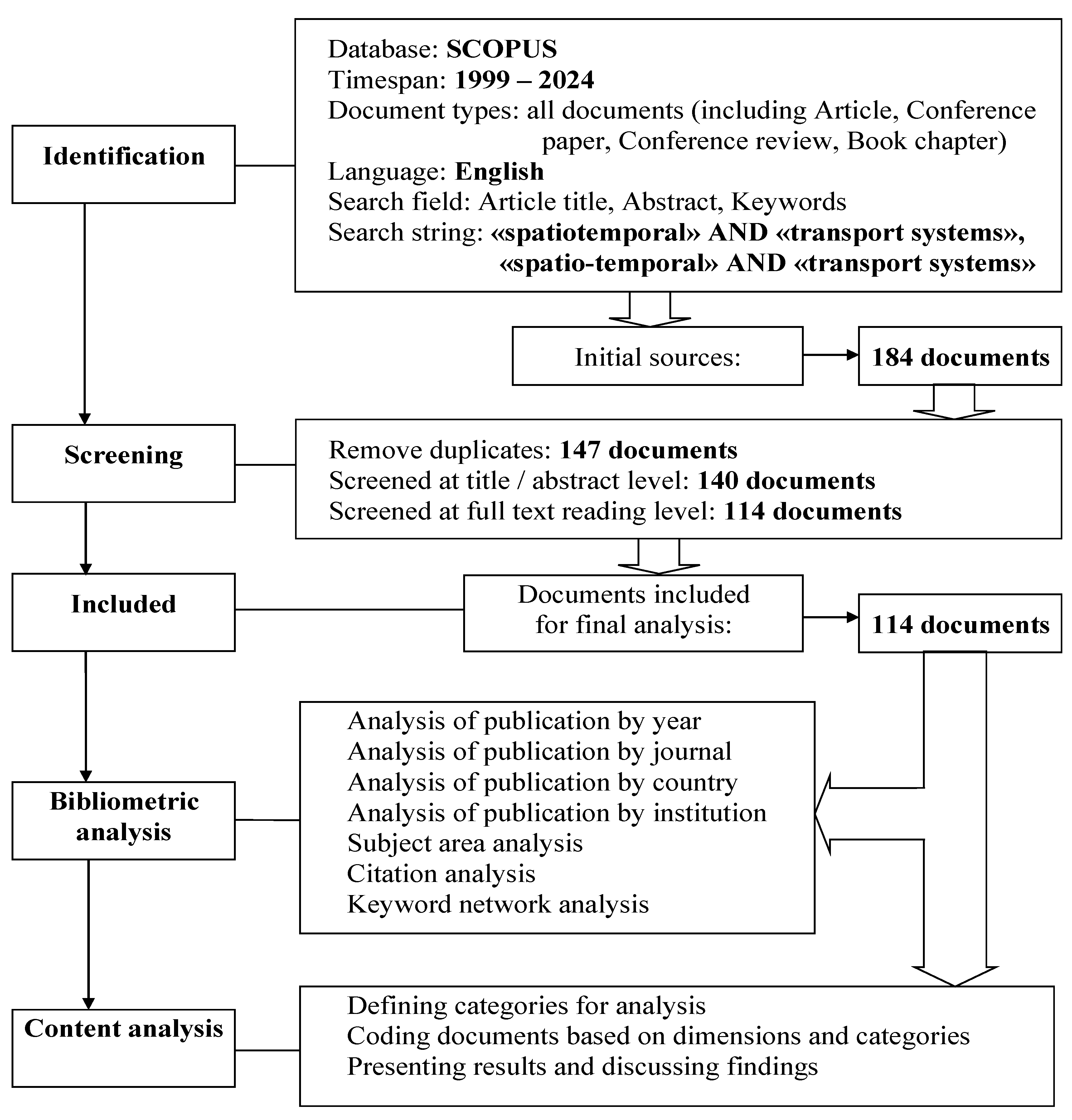
2. Research Method
- The papers should contain the keywords “Spatio-Temporal graph” and “Transport systems”. The filter [Article title, Abstract, Keywords] was used as a criterion for selecting publications.
- Papers should be indexed in the Scopus database and should include articles in peer-reviewed English language journals, conference proceedings, and book chapters on the field under study.
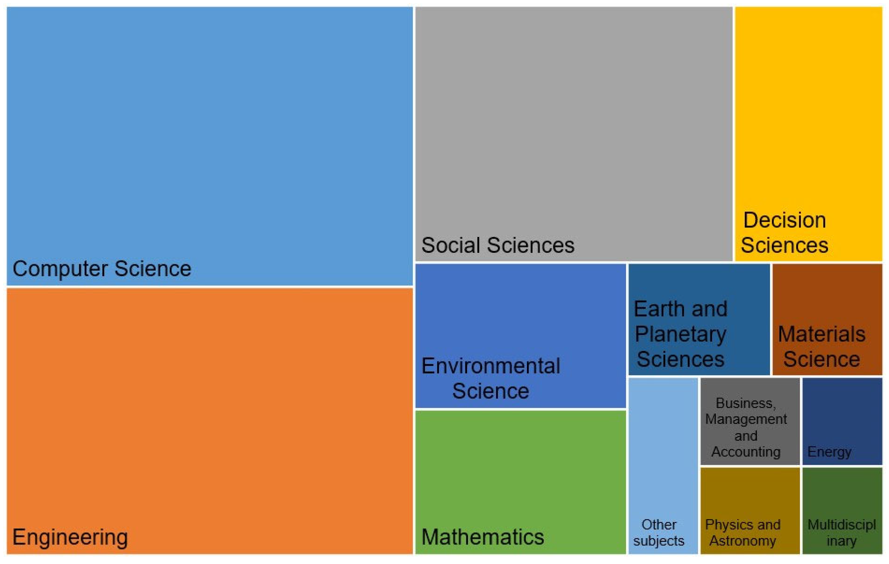
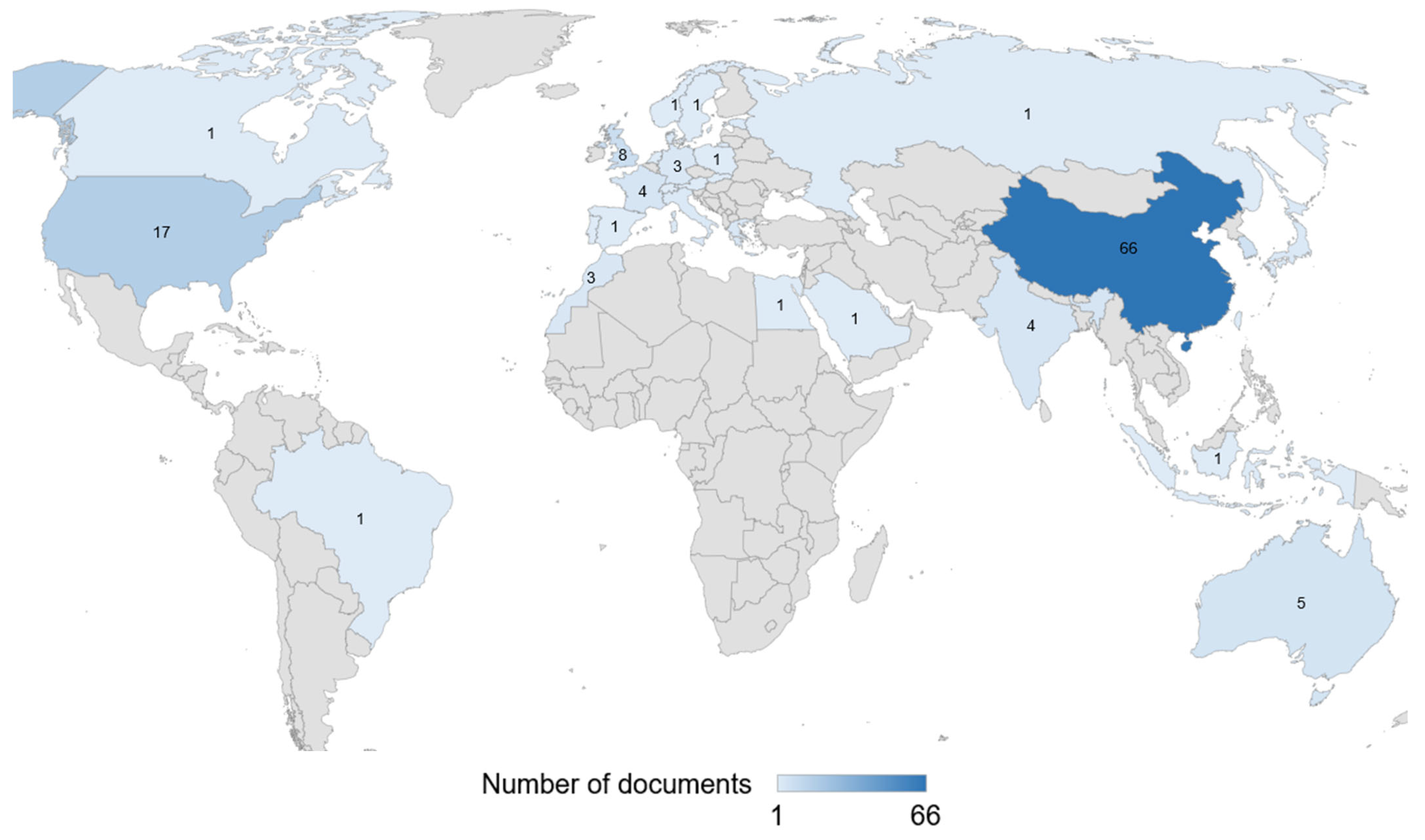
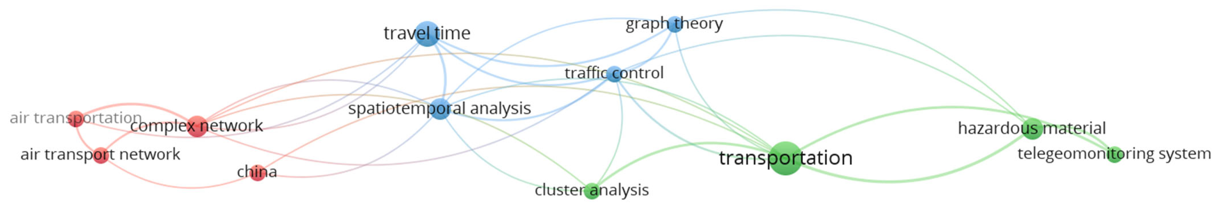
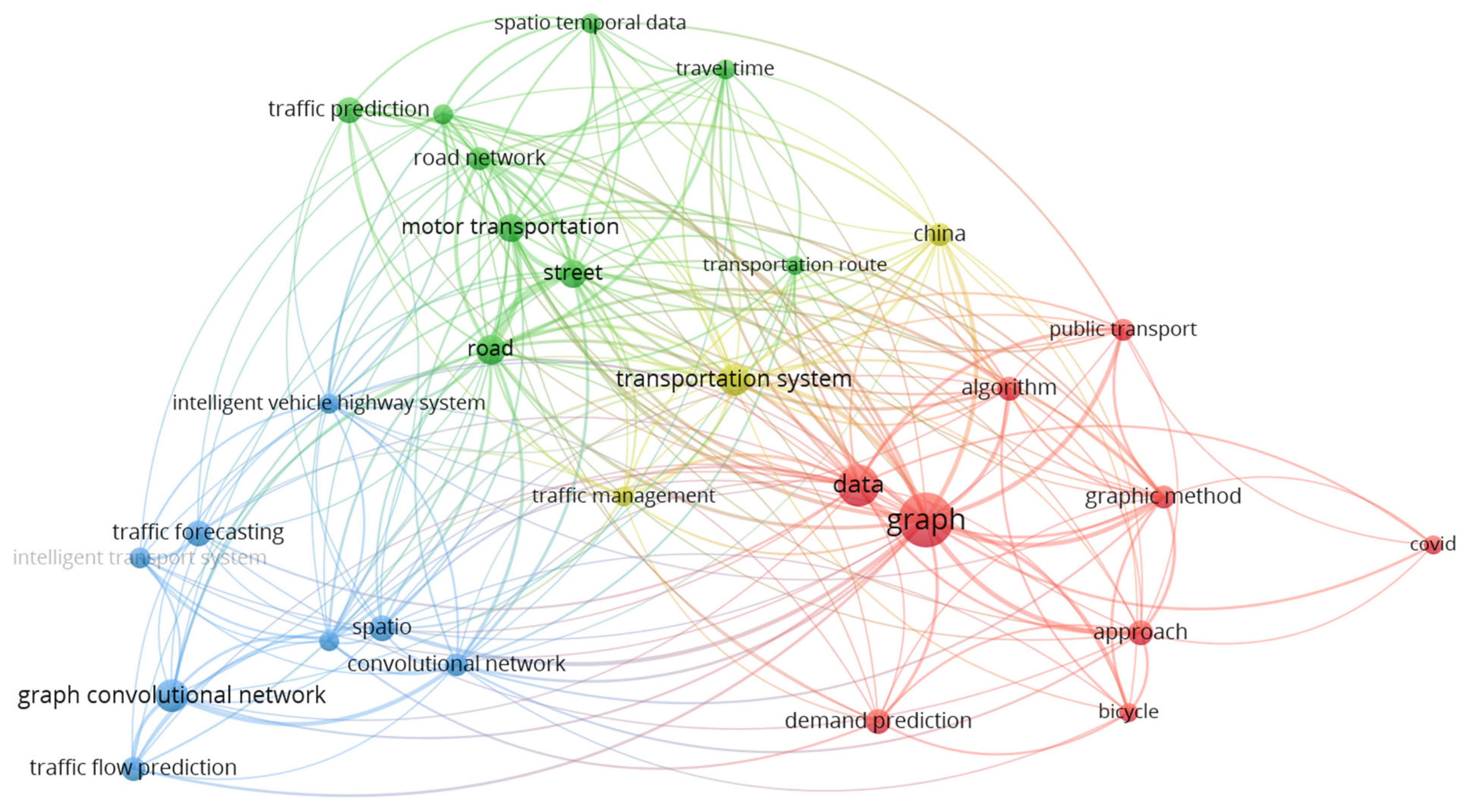
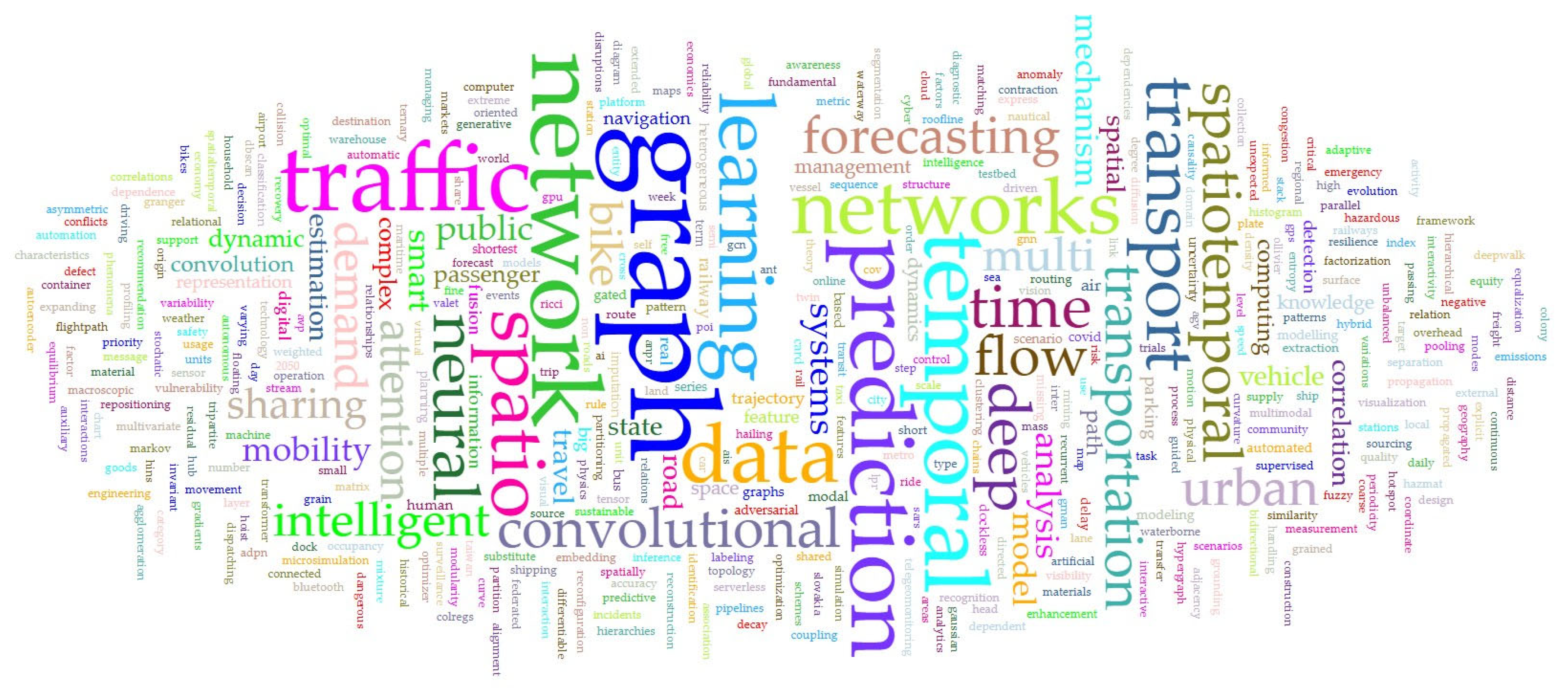
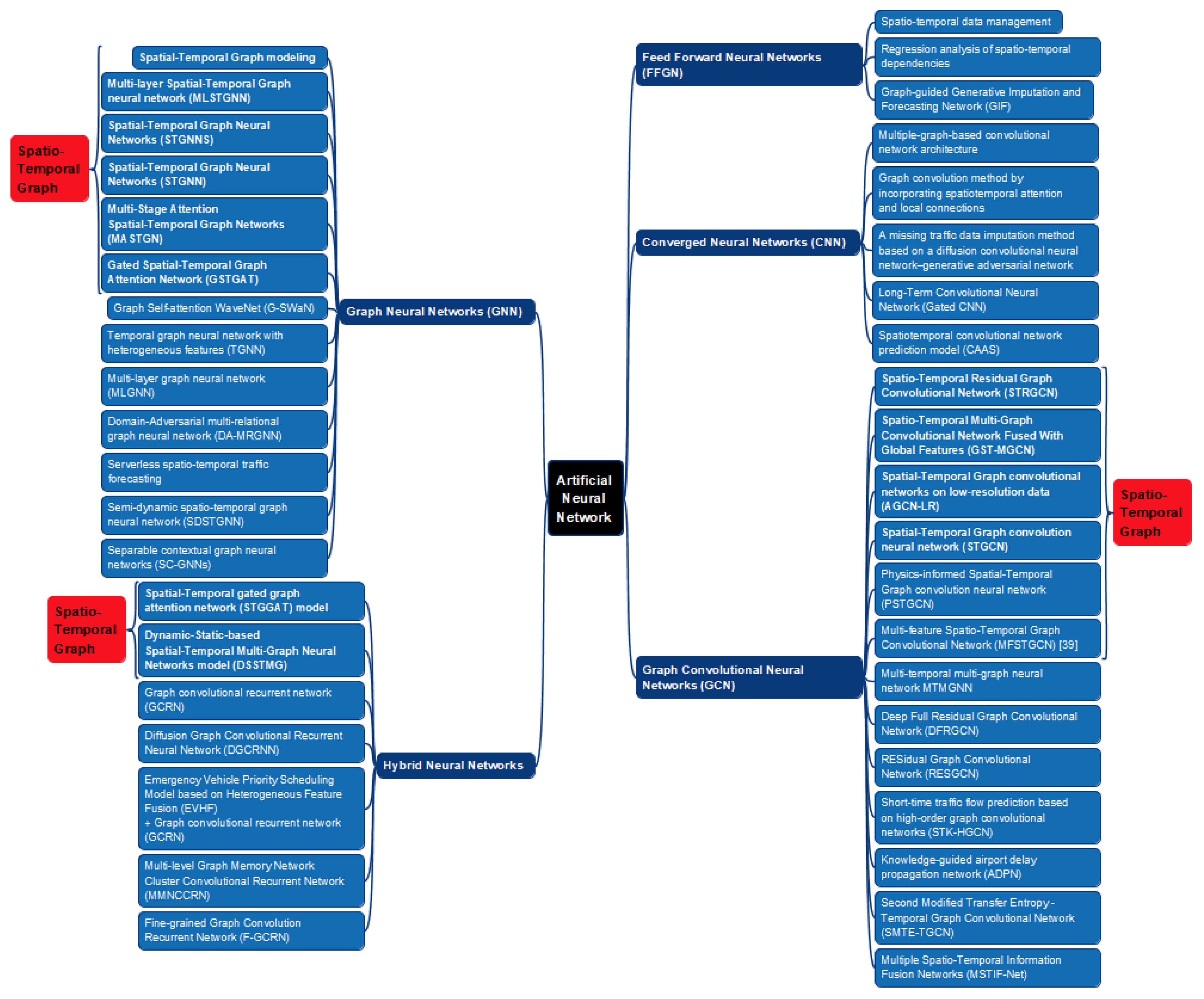
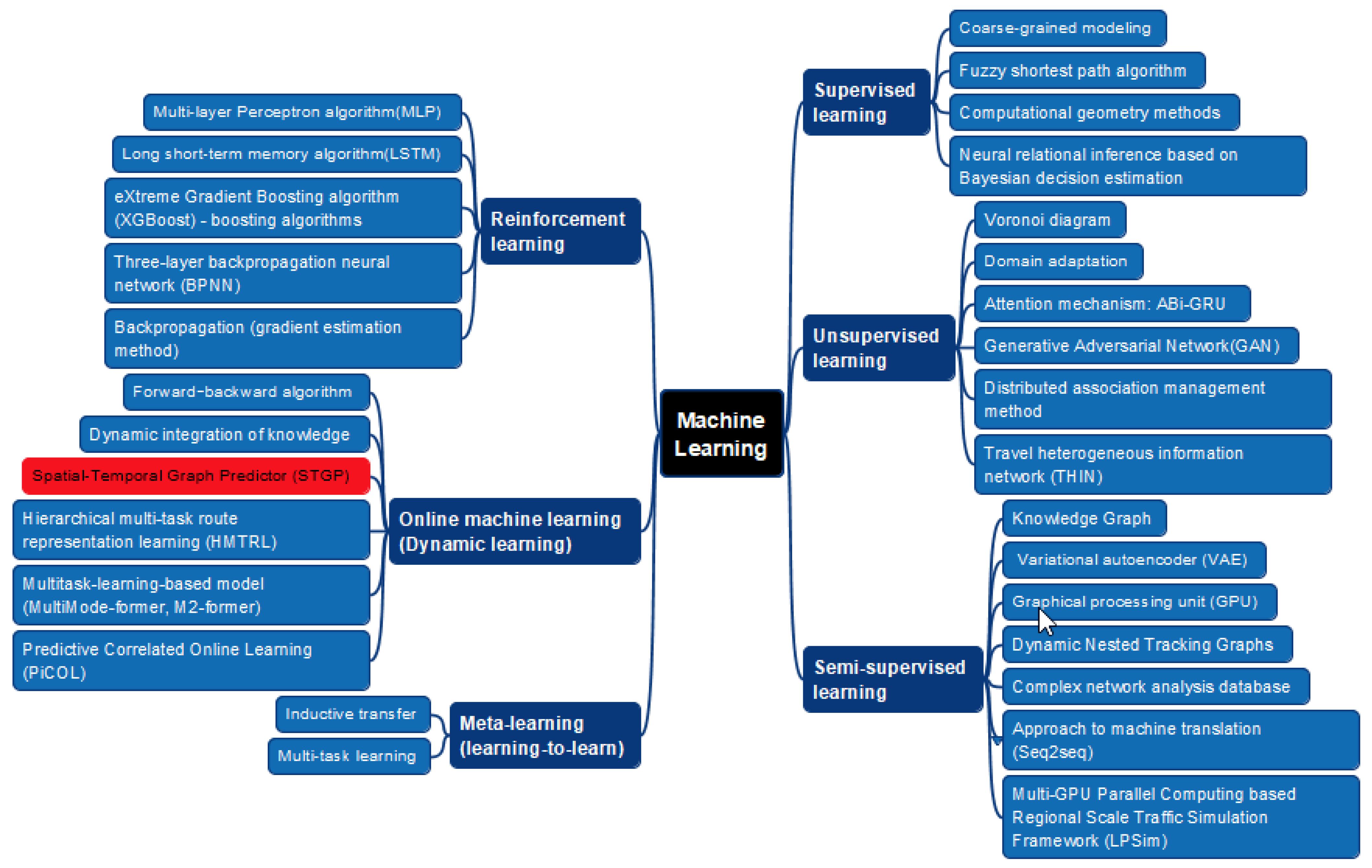
3. Results
4. Conclusions
- Only the Scopus database was used for analysis.
- The filter [Article title, Abstract, Keywords] was applied as a search criterion.
- Only specific keyword combinations (“spatiotemporal”, “spatio-temporal”, “transport systems”) were used, which limited the depth of analysis and provided only an initial understanding of the use of spatio-temporal graphs in transportation.
- Open-source software with functional limitations was used for bibliometric analysis.
- Utilizing additional databases for searching scientific publications, such as Web of Science.
- Enhancing the methodology for analyzing publications by incorporating more complex and statistically oriented text analysis methods (e.g., topic modeling, word embeddings, etc.).
- Applying additional search filters for articles and exploring alternative keywords and their combinations. The results of this study indicate that relevant keywords may include “optimization”, “dynamic optimization”, “hybrid methods”, “spatio-temporal graph neural networks”, “combined model” or “hybrid model”, “deep learning”, and “hybrid neural network”.
- Implementing specialized software tools to support deeper analysis and provide a more reliable statistical foundation for research.
Author Contributions
Funding
Data Availability Statement
Conflicts of Interest
References
- Rakhmangulov, A.N.; Kornilov, S.N.; Kolga, A.D. Timeliness of Freight Traffic in Transport Technological Systems. Vestn. Nosov Magnitogorsk State Tech. Univ. 2014, 45, 115–121. [Google Scholar]
- Rakhmangulov, A.; Sładkowski, A.; Osintsev, N. Design of an ITS for industrial enterprises. In Intelligent Transportation Systems—Problems and Perspectives; Sładkowski, A., Pamuła, W., Eds.; Springer International Publishing: Cham, Switzerland, 2016; pp. 161–215. ISBN 978-3-319-19149-2. [Google Scholar]
- Laiton-Bonadiez, C.; Branch-Bedoya, J.W.; Zapata-Cortes, J.; Paipa-Sanabria, E.; Arango-Serna, M. Industry 4.0 technologies applied to the rail transportation industry: A systematic review. Sensors 2022, 22, 2491. [Google Scholar] [CrossRef] [PubMed]
- Kljaić, Z.; Pavković, D.; Cipek, M.; Trstenjak, M.; Mlinarić, T.J.; Nikšić, M. An overview of current challenges and emerging technologies to facilitate increased energy efficiency, safety, and sustainability of railway transport. Future Internet 2023, 15, 347. [Google Scholar] [CrossRef]
- Jin, G.; Liang, Y.; Fang, Y.; Shao, Z.; Huang, J.; Zhang, J.; Zheng, Y. Spatio-Temporal Graph Neural Networks for Predictive Learning in Urban Computing: A Survey; Institute of Electrical and Electronics Engineers: New York, NY, USA, 2023. [Google Scholar]
- Anda, C.; Erath, A.; Fourie, P.J. Transport modelling in the age of big data. Int. J. Urban Sci. 2017, 21, 19–42. [Google Scholar] [CrossRef]
- van Nes, R.; de Jong, G. Transport models. In Standard Transport Appraisal Methods; Elsevier: Amsterdam, The Netherlands, 2020; pp. 101–128. ISBN 9780128208212. [Google Scholar]
- Jain, S.K.; Singh, V.P. Systems analysis techniques. In Water Resources Systems Planning and Management; Elsevier: Amsterdam, The Netherlands, 2003; pp. 279–350. ISBN 9780444514295. [Google Scholar]
- Terentyev, A.; Marusin, A.; Evtyukov, S.; Marusin, A.; Shevtsova, A.; Zelenov, V. Analytical model for information flow management in intelligent transport systems. Mathematics 2023, 11, 3371. [Google Scholar] [CrossRef]
- Ali, M. Discrete choice models and artificial intelligence techniques for predicting the determinants of transport mode choice—A systematic review. Comput. Mater. Contin. 2024, 81, 2161–2194. [Google Scholar] [CrossRef]
- Pouryousef, H.; Lautala, P.; White, T. Railroad capacity tools and methodologies in the U.S. and Europe. J. Mod. Transp. 2015, 23, 30–42. [Google Scholar] [CrossRef]
- Mancera, A.; Bruckman, D.; Weidmann, U. Single wagonload production schemes improvements using GüterSim (Agent-based simulation tool). Transp. Res. Procedia 2015, 10, 615–624. [Google Scholar] [CrossRef]
- Bueno-Ferrer, Á.; de Pablo Valenciano, J.; de Burgos Jiménez, J. Unveiling the potential of metaheuristics in transportation: A path towards efficiency, optimization, and intelligent management. Infrastructures 2025, 10, 4. [Google Scholar] [CrossRef]
- Colombaroni, C.; Fusco, G.; Isaenko, N. Meta-heuristic aggregate calibration of transport models exploiting data collected in mobility. Case Stud. Transp. Policy 2023, 13, 101039. [Google Scholar] [CrossRef]
- Dou, Z.; Guo, D. DPSTCN: Dynamic Pattern-Aware Spatio-Temporal Convolutional Networks for Traffic Flow Forecasting. IJGI 2025, 14, 10. [Google Scholar] [CrossRef]
- Rakhmangulov, A.; Sładkowski, A.; Osintsev, N.; Mishkurov, P.; Muravev, D. Dynamic Optimization of Railcar Traffic Volumes at Railway Nodes. In Rail Transport—Systems Approach; Sładkowski, A., Ed.; Springer International Publishing: Cham, Switzerland, 2017; pp. 405–456. ISBN 978-3-319-51501-4. [Google Scholar]
- Cheramangalath, U.; Nasre, R.; Srikant, Y.N. Distributed Graph Analytics; Springer International Publishing: Cham, Switzerland, 2020; ISBN 978-3-030-41885-4. [Google Scholar]
- Mahmudy, W.F.; Widodo, A.W.; Haikal, A.H. Challenges and opportunities for applying meta-heuristic methods in vehicle routing problems: A review. Eng. Proc. 2024, 63, 12. [Google Scholar] [CrossRef]
- Murrar, S.; Alhaj, F.M.; Qutqut, M. Machine learning algorithms for transportation mode pprediction: A comparative analysis. Informatica 2024, 48, 6. [Google Scholar] [CrossRef]
- Zhao, S.; Xing, S.; Mao, G. An attention and wavelet based spatial-temporal graph neural network for traffic flow and speed prediction. Mathematics 2022, 10, 3507. [Google Scholar] [CrossRef]
- Cui, J.-X.; Yao, J.; Zhao, B.-Y. Review on short-term traffic flow prediction methods based on deep learning. J. Traffic Transp. Eng. 2024, 24, 50–64. [Google Scholar] [CrossRef]
- Sun, X.; Yu, H.; Solvang, W.D.; Wang, Y.; Wang, K. The application of Industry 4.0 technologies in sustainable logistics: A systematic literature review (2012-2020) to explore future research opportunities. Environ. Sci. Pollut. Res. Int. 2022, 29, 9560–9591. [Google Scholar] [CrossRef] [PubMed]
- VOSviewer. Available online: https://www.vosviewer.com/ (accessed on 20 February 2025).
- PRISMA. Available online: https://www.prisma.io/ (accessed on 8 December 2024).
- Saeedmanesh, M.; Geroliminis, N. Clustering of heterogeneous networks with directional flows based on “Snake” similarities. Transp. Res. Part B Methodol. 2016, 91, 250–269. [Google Scholar] [CrossRef]
- Zhou, X. Understanding spatiotemporal patterns of biking behavior by analyzing massive bike sharing data in Chicago. PLoS ONE 2015, 10, e0137922. [Google Scholar] [CrossRef]
- Yang, Y.; Heppenstall, A.; Turner, A.; Comber, A. A spatiotemporal and graph-based analysis of dockless bike sharing patterns to understand urban flows over the last mile. Comput. Environ. Urban Syst. 2019, 77, 101361. [Google Scholar] [CrossRef]
- Zhang, C.; Yu, J.J.Q.; Liu, Y. Spatial-Temporal Graph Attention Networks: A Deep Learning Approach for Traffic Forecasting. IEEE Access 2019, 7, 166246–166256. [Google Scholar] [CrossRef]
- Jin, G.; Cui, Y.; Zeng, L.; Tang, H.; Feng, Y.; Huang, J. Urban ride-hailing demand prediction with multiple spatio-temporal information fusion network. Transp. Res. Part C Emerg. Technol. 2020, 117, 102665. [Google Scholar] [CrossRef]
- Rathore, M.M.; Attique Shah, S.; Awad, A.; Shukla, D.; Vimal, S.; Paul, A. A cyber-physical system and graph-based approach for transportation management in smart cities. Sustainability 2021, 13, 7606. [Google Scholar] [CrossRef]
- Qin, K.; Xu, Y.; Kang, C.; Kwan, M.-P. A graph convolutional network model for evaluating potential congestion spots based on local urban built environments. Trans. GIS 2020, 24, 1382–1401. [Google Scholar] [CrossRef]
- Kyriakou, K.; Lakakis, K.; Savvaidis, P.; Basbas, S. Analysis of spatiotemporal data to predict traffic conditions aiming at a smart navigation system for sustainable urban mobility. Arch. Transp. 2019, 52, 27–46. [Google Scholar] [CrossRef]
- Furno, A.; Faouzi, N.-E.E.; Sharma, R.; Zimeo, E. Graph-based ahead monitoring of vulnerabilities in large dynamic transportation networks. PLoS ONE 2021, 16, e0248764. [Google Scholar] [CrossRef]
- Zhao, P.; Liu, X.; Shen, J.; Chen, M. A network distance and graph-partitioning-based clustering method for improving the accuracy of urban hotspot detection. Geocarto Int. 2019, 34, 293–315. [Google Scholar] [CrossRef]
- Myrovali, G.; Karakasidis, T.; Charakopoulos, A.; Tzenos, P.; Morfoulaki, M.; Aifadopoulou, G. Exploiting the knowledge of dynamics, correlations and causalities in the performance of different road paths for enhancing urban transport management. In Decision Support Systems IX: Main Developments and Future Trends; Freitas, P.S.A., Dargam, F., Moreno, J.M., Eds.; Springer International Publishing: Cham, Switzerland, 2019; pp. 28–40. ISBN 978-3-030-18818-4. [Google Scholar]
- Tygesen, M.N.; Pereira, F.C.; Rodrigues, F. Unboxing the graph: Towards interpretable graph neural networks for transport prediction through neural relational inference. Transp. Res. Part C Emerg. Technol. 2023, 146, 103946. [Google Scholar] [CrossRef]
- Tang, H.; Wu, Y.; Guo, Z. Graph multi-attention network-based taxi demand prediction. In 2022 4th International Conference on Data-Driven Optimization of Complex Systems (DOCS), Proceedings of the 2022 4th International Conference on Data-Driven Optimization of Complex Systems (DOCS), Chengdu, China, 28–30 October 2022; Institute of Electrical and Electronics Engineers: New York, NY, USA, 2022; pp. 1–6. ISBN 978-1-6654-5982-2. [Google Scholar]
- Lyu, C.; Wu, X.; Liu, Y.; Liu, Z. A partial-fréchet-distance-based framework for bus route identification. IEEE Trans. Intell. Transp. Syst. 2022, 23, 9275–9280. [Google Scholar] [CrossRef]
- Lee, K.; Park, J.S.; Goh, S.; Choi, M. Accessibility measurement in transportation networks and application to the Seoul bus system. Geogr. Anal. 2019, 51, 339–353. [Google Scholar] [CrossRef]
- Hou, M.; Xia, F.; Chen, X.; Saikrishna, V.; Chen, H. Adaptive spatio-temporal graph learning for bus station profiling. ACM Trans. Spat. Algorithms Syst. 2024, 10, 25. [Google Scholar] [CrossRef]
- Xiao, S.; Shi, Q.; Shao, L.; Du, B.; Wang, Y.; Shen, Q.; Zeng, W. MetroBUX: A Topology-Based Visual Analytics for Bus Operational Uncertainty EXploration. IEEE Trans. Intell. Transp. Syst. 2024, 25, 5525–5538. [Google Scholar] [CrossRef]
- Peng, J.; Zhang, G.; Wang, T.; Wang, P.; Zhang, T. A trajectory-driven multi-layer spatiotemporal graph neural network for predicting short-term urban traffic state. J. Geo-Inf. Sci. 2024, 26, 2300–2315. [Google Scholar] [CrossRef]
- Li, W.; Liu, C.; Wang, T.; Ji, Y. An innovative supervised learning structure for trajectory reconstruction of sparse LPR data. Transportation 2024, 51, 73–97. [Google Scholar] [CrossRef]
- Tang, J.; Zeng, J. Spatiotemporal gated graph attention network for urban traffic flow prediction based on license plate recognition data. Comput. Aided Civil Infrastruct. Eng. 2022, 37, 3–23. [Google Scholar] [CrossRef]
- Chen, Y.; He, Z. Vehicle identity recovery for automatic number plate recognition data via heterogeneous network embedding. Sustainability 2020, 12, 3074. [Google Scholar] [CrossRef]
- Zhao, X.; Zhang, M. Enhancing predictive models for on-street parking occupancy: Integrating adaptive GCN and GRU with household categories and POI factors. Mathematics 2024, 12, 2823. [Google Scholar] [CrossRef]
- Chen, T.; Sun, C. An optimization design of hybrid parking lots in an automated environment. Sustainability 2023, 15, 15475. [Google Scholar] [CrossRef]
- Ma, W.; Pi, X.; Qian, S. Estimating multi-class dynamic origin-destination demand through a forward-backward algorithm on computational graphs. Transp. Res. Part C Emerg. Technol. 2020, 119, 102747. [Google Scholar] [CrossRef]
- Boulmakoul, A.; Karim, L.; Laarabi, M.H.; Sacile, R.; Garbolino, E. MongoDB-hadoop distributed and scalable framework for spatio-temporal hazardous materials data warehousing. In The 7th International Congress on Environmental Modelling and Software, Proceedings of the 7th International Congress on Environmental Modeling and Software (iEMSs), San Diego, CA, USA, 15–19 June 2014; iEMSs: San Diego, CA, USA, 2014; pp. 2255–2262. [Google Scholar]
- Mimeur, C.; Thévenin, T. Diachronic analysis of the growth of the French railway network between 1860 and 1930: Connectionist expansion and hierarchical selection? Flux 2021, 122, 69–87. [Google Scholar] [CrossRef]
- Guo, Y.; Zhu, Q.; Ding, Y.; Li, Y.; Wu, H.; He, Y.; Li, Z.; Li, H.; Zhang, L.; Zhao, Y.; et al. Efficient distributed association management method of data, model, and knowledge for digital twin railway. Int. J. Digit. Earth 2024, 17, 2340089. [Google Scholar] [CrossRef]
- Li, H.; Zhu, Q.; Zhang, L.; Ding, Y.; Guo, Y.; Wu, H.; Wang, Q.; Zhou, R.; Liu, M.; Zhou, Y. Integrated representation of geospatial data, model, and knowledge for digital twin railway. Int. J. Digit. Earth 2022, 15, 1657–1675. [Google Scholar] [CrossRef]
- Wang, C. Identification of inter-urban container transport hubs and their spatial characteristics: A case study of railway transportation in China. Acta Geogr. Sin. 2010, 25, 1275–1286. [Google Scholar]
- Zhang, Q.; Ma, Z.; Zhang, P.; Jenelius, E. Mobility knowledge graph: Review and its application in public transport. Transportation 2023, 40, 1–27. [Google Scholar] [CrossRef]
- Heglund, J.S.; Taleongpong, P.; Hu, S.; Tran, H.T. Railway delay prediction with spatial-temporal graph convolutional networks. In 2020 IEEE 23rd International Conference on Intelligent Transportation Systems (ITSC), Proceedings of the 2020 IEEE 23rd International Conference on Intelligent Transportation Systems (ITSC), Rhodes, Greece, 20–23 September 2020; Institute of Electrical and Electronics Engineers: New York, NY, USA, 2020; pp. 1–6. ISBN 978-1-7281-4149-7. [Google Scholar]
- Zou, L.; Wang, Z.; Guo, R. Real-time prediction of transit origin–destination flows during underground incidents. Transp. Res. Part C Emerg. Technol. 2024, 163, 104622. [Google Scholar] [CrossRef]
- Wang, Q.; He, R.; Zhu, C.; Rao, H. Short-time passenger flow prediction of new urban rail transit based on graph convolutional neural network. IAENG Int. J. Comput. Sci. 2024, 51, 1612–1626. [Google Scholar]
- Fu, J.; Zhong, L.; Li, C.; Li, H.; Kong, C.; Shao, J. SPSTN: Sequential Precoding Spatial-Temporal Networks for Railway Delay Prediction. In Web and Big Data; Li, B., Yue, L., Tao, C., Han, X., Calvanese, D., Amagasa, T., Eds.; Springer Nature: Cham, Switzerland, 2023; pp. 451–458. ISBN 978-3-031-25157-3. [Google Scholar]
- Rahmawan Destyanto, A.; Huang, Y.; Verbraeck, A. Examining the spatiotemporal changing pattern of freight maritime transport networks in Indonesia during COVID-19 outbreaks. In 4th Asia Pacific Conference on Research in Industrial and Systems Engineering 2021, Proceedings of the APCORISE 2021: 4th Asia Pacific Conference on Research in Industrial and Systems Engineering 2021, Depok Indonesia, 25 May 2021; Ardi, R., Moeis, A.O., Eds.; ACM: New York, NY, USA, 2021; pp. 590–597. ISBN 9781450390385. [Google Scholar]
- Dong, W.; Zhang, L.; Jin, Z.; Sun, W.; Gao, J. Prediction of the waterborne navigation density based on the multi-feature spatio-temporal graph convolution network. Chin. J. Internet Things 2020, 4, 78–85. [Google Scholar] [CrossRef]
- Li, L.; Pan, M.; Liu, Z.; Sun, H.; Zhang, R. Semi-dynamic spatial–temporal graph neural network for traffic state prediction in waterways. Ocean Eng. 2024, 293, 116685. [Google Scholar] [CrossRef]
- Bakdi, A.; Glad, I.K.; Vanem, E. Testbed scenario design exploiting traffic big data for autonomous ship trials under multiple conflicts with collision/grounding risks and spatiooral dependencies. IEEE Trans. Intell. Transp. Syst. 2021, 22, 7914–7930. [Google Scholar] [CrossRef]
- Wang, J.-E.; Mo, H.-H. Complex evolution process of China’s air transport network. J. Transp. Syst. Eng. Inf. Technol. 2014, 14, 71–80. [Google Scholar]
- Wan, J.; Zhang, H.; Zhang, Q.; Li, M.Z.; Xu, Y. Deep learning framework for forecasting en route airspace emissions considering temporal-spatial correlation. Sci. Total Environ. 2023, 905, 166986. [Google Scholar] [CrossRef]
- Lehner, S.; Kölker, K.; Lütjens, K. Evaluating temporal integration of European air transport. In ICAS 2014, Proceedings of the 29th Congress of the International Council of the Aeronautical Sciences St. Peterburg, Russia 7–12 September 2014; CD-ROM Proceedings; International Council of the Aeronautical Sciences: Bonn, Germany, 2014; ISBN 3932182804. [Google Scholar]
- Sun, M.; Tian, Y.; Wang, X.; Huang, X.; Li, Q.; Li, Z.; Li, J. Transport causality knowledge-guided GCN for propagated delay prediction in airport delay propagation networks. Expert Syst. Appl. 2024, 240, 122426. [Google Scholar] [CrossRef]
- Liang, Y.; Huang, G.; Zhao, Z. Bike sharing demand prediction based on knowledge sharing across modes: A graph-based deep learning approach. In 2022 IEEE 25th International Conference on Intelligent Transportation Systems (ITSC), Proceedings of the 2022 IEEE 25th International Conference on Intelligent Transportation Systems (ITSC), Macau, China, 8–12 October 2022; IEEE: New York, NY, USA, 2022; pp. 857–862. ISBN 978-1-6654-6880-0. [Google Scholar]
- Yang, X.; He, S.; Shin, K.G.; Tabatabaie, M.; Dai, J. Cross-modality and equity-aware graph pooling fusion: A bike mobility prediction study. IEEE Trans. Big Data 2024, 11, 286–302. [Google Scholar] [CrossRef]
- Liang, Y.; Huang, G.; Zhao, Z. Cross-mode knowledge adaptation for bike sharing demand prediction using domain-adversarial graph neural networks. IEEE Trans. Intell. Transp. Syst. 2024, 25, 3642–3653. [Google Scholar] [CrossRef]
- Xu, X.; Wang, J.; Poslad, S.; Rui, X.; Zhang, G.; Fan, Y. Exploring intra-urban human mobility and daily activity patterns from the lens of dockless bike-sharing: A case study of Beijing, China. Int. J. Appl. Earth Obs. Geoinf. 2023, 122, 103442. [Google Scholar] [CrossRef]
- Kim, T.S.; Lee, W.K.; Sohn, S.Y. Graph convolutional network approach applied to predict hourly bike-sharing demands considering spatial, temporal, and global effects. PLoS ONE 2019, 14, e0220782. [Google Scholar] [CrossRef]
- Qin, T.; Liu, T.; Wu, H.; Tong, W.; Zhao, S. RESGCN: RESidual Graph Convolutional Network based free dock prediction in bike sharing system. In 2020 21st IEEE International Conference on Mobile Data Management (MDM), Proceedings of the 2020 21st IEEE International Conference on Mobile Data Management (MDM), Versailles, France, 30 Jun–3 July 2020; IEEE: New York, NY, USA, 2020; pp. 210–217. ISBN 978-1-7281-4663-8. [Google Scholar]
- Song, J.; Zhang, L.; Qin, Z.; Ramli, M.A. Spatiotemporal evolving patterns of bike-share mobility networks and their associations with land-use conditions before and after the COVID-19 outbreak. Physica A 2022, 592, 126819. [Google Scholar] [CrossRef] [PubMed]
- Kubaľák, S.; Kalašová, A.; Hájnik, A. The bike-sharing system in slovakia and the impact of COVID-19 on this shared mobility service in a selected city. Sustainability 2021, 13, 6544. [Google Scholar] [CrossRef]
- Yang, Y.; Heppenstall, A.; Turner, A.; Comber, A. Using graph structural information about flows to enhance short-term demand prediction in bike-sharing systems. Comput. Environ. Urban Syst. 2020, 83, 101521. [Google Scholar] [CrossRef]
- Wang, Y.-J.; Kuo, Y.-H.; Huang, G.Q.; Gu, W.; Hu, Y. Dynamic demand-driven bike station clustering. Transp. Res. Part E Logist. Transp. Rev. 2022, 160, 102656. [Google Scholar] [CrossRef]
- Tian, Z.; Zhou, J.; Tian, L.; Wang, D.Z. Dynamic spatio-temporal interactive clustering strategy for free-floating bike-sharing. Transp. Res. Part B Methodol. 2024, 179, 102872. [Google Scholar] [CrossRef]
- Kopsidas, A.; Kepaptsoglou, K. Identification of critical stations in a Metro System: A substitute complex network analysis. Phys. A Stat. Mech. Its Appl. 2022, 596, 127123. [Google Scholar] [CrossRef]
- Du, Y.; Jiang, R.; Deng, J.; Li, Y.; Xie, Y.; Wang, Z.; Zhou, Y.; Song, X.; Shang, J.S. MTMGNN: Multi-time multi-graph neural network for metro passenger flow prediction. GeoInformatica 2023, 27, 77–105. [Google Scholar] [CrossRef]
- Chang, X.; Wu, J.; Yu, J.; Liu, T.; Yan, X.; Lee, D.-H. Addressing COVID-induced changes in spatiotemporal travel mobility and community structure utilizing trip data: An innovative graph-based deep learning approach. Transp. Res. Part A Policy Pract. 2024, 180, 103973. [Google Scholar] [CrossRef]
- Mahajan, S.; Tang, Y.-S.; Wu, D.-Y.; Tsai, T.-C.; Chen, L.-J. CAR: The Clean Air Routing algorithm for path navigation with minimal PM2.5 exposure on the move. IEEE Access 2019, 7, 147373–147382. [Google Scholar] [CrossRef]
- Rodrigues, D.O.; Fernandes, J.T.; Curado, M.; Villas, L.A. Hybrid context-aware multimodal routing. In 2018 21st International Conference on Intelligent Transportation Systems (ITSC), Proceedings of the 2018 21st International Conference on Intelligent Transportation Systems (ITSC), Maui, HI, USA, 4–7 November 2018; IEEE: New York, NY, USA, 2018; pp. 2250–2255. ISBN 978-1-7281-0321-1. [Google Scholar]
- Liu, H.; Han, J.; Fu, Y.; Zhou, J.; Lu, X.; Xiong, H. Multi-modal transportation recommendation with unified route representation learning. Proc. VLDB Endow. 2020, 14, 342–350. [Google Scholar] [CrossRef]
- Liu, H.; Han, J.; Fu, Y.; Li, Y.; Chen, K.; Xiong, H. Unified route representation learning for multi-modal transportation recommendation with spatiotemporal pre-training. VLDB J. 2023, 32, 325–342. [Google Scholar] [CrossRef]
- Li, C.; Liu, W. Multimodal transport demand forecasting via federated learning. IEEE Trans. Intell. Transp. Syst. 2024, 25, 4009–4020. [Google Scholar] [CrossRef]
- Li, C.; Liu, W.; Yang, H. Simultaneous multimodal demand imputation and forecasting via graph-guided generative network. In Proceedings of the 27th International Conference of Hong Kong Society for Transportation Studies: Transport and Equity, HKSTS 2023, Hong Kong, China, 12 November–12 December 2023; pp. 509–517. [Google Scholar]
- Shao, Y.; Ma, J.; Zavala, V.M. A spatial superstructure approach to the optimal design of modular processes and supply chains. Comput. Chem. Eng. 2023, 170, 108102. [Google Scholar] [CrossRef]
- Fang, K.; Fan, J.; Yu, B. A trip-based network travel risk: Definition and prediction. Ann. Oper. Res. 2022, 343, 1069–1094. [Google Scholar] [CrossRef]
- Tominac, P.A.; Zhang, W.; Zavala, V.M. Spatio-temporal economic properties of multi-product supply chains. Comput. Chem. Eng. 2022, 159, 107666. [Google Scholar] [CrossRef]
- Feng, S.; Wei, S.; Zhang, J.; Li, Y.; Ke, J.; Chen, G.; Zheng, Y.; Yang, H. A macro–micro spatio-temporal neural network for traffic prediction. Transp. Res. Part C Emerg. Technol. 2023, 156, 104331. [Google Scholar] [CrossRef]
- Li, G.; Wang, J.; Zhao, Z.; Chen, Y.; Tang, L.; Li, Q. Advancing complex urban traffic forecasting: A fully attentional spatial-temporal network enhanced by graph representation. Int. J. Appl. Earth Obs. Geoinf. 2024, 134, 104237. [Google Scholar] [CrossRef]
- Prabowo, A.; Shao, W.; Xue, H.; Koniusz, P.; Salim, F.D. Because every sensor is unique, so is every pair: Handling dynamicity in traffic forecasting. In IoTDI ‘23: International Conference on Internet-of-Things Design and Implementation, Proceedings of the 8th ACM/IEEE Conference on Internet of Things Design and Implementation, San Antonio TX USA, 9–12 May 2023; ACM: New York, NY, USA, 2023; pp. 93–104. ISBN 9798400700378. [Google Scholar]
- Oakley, J.; Conlan, C.; Demirci, G.V.; Sfyridis, A.; Ferhatosmanoglu, H. Foresight plus: Serverless spatio-temporal traffic forecasting. GeoInformatica 2024, 28, 649–677. [Google Scholar] [CrossRef]
- Sun, L.; Dai, W.; Muhammad, G. Multi-level graph memory network cluster convolutional recurrent network for traffic forecasting. Inf. Fusion 2024, 105, 102214. [Google Scholar] [CrossRef]
- Yin, X.; Wu, G.; Wei, J.; Shen, Y.; Qi, H.; Yin, B. Multi-stage attention spatial-temporal graph networks for traffic prediction. Neurocomputing 2021, 428, 42–53. [Google Scholar] [CrossRef]
- Shi, Z.; Chen, Y.; Liu, J.; Fan, D.; Liang, C. Physics-informed spatiotemporal learning framework for urban traffic state estimation. J. Transp. Eng. Part A Syst. 2023, 149, 04023056. [Google Scholar] [CrossRef]
- Shirakami, R.; Kitahara, T.; Takeuchi, K.; Kashima, H. Queue length prediction using traffic-theory-based deep learning. Trans. Jpn. Soc. Artif. Intell. 2024, 39, 1–12. [Google Scholar] [CrossRef]
- Wang, Q.; He, R.; Zhu, C.; Rao, H. Short-time traffic flow prediction based on high-order graph convolutional networks. Int. J. Comput. Sci. 2024, 51, 1612–1626. [Google Scholar]
- Rao, K.V.; Selvakumar, R.K. Spatiotemporal graph neural networks for traffic forecasting: A comparative analysis. In Advanced Engineering Optimization Through Intelligent Techniques; Venkata Rao, R., Taler, J., Eds.; Springer Nature: Singapore, 2024; pp. 451–463. ISBN 978-981-97-4653-8. [Google Scholar]
- Ku, Y.; Wang, Y.; Liu, Q.; Yang, Y.; Peng, L. TEDGCN: Asymmetric spatiotemporal GNN for heterogeneous traffic prediction. In 2023 IEEE 26th International Conference on Intelligent Transportation Systems (ITSC), Proceedings of the 2023 IEEE 26th International Conference on Intelligent Transportation Systems (ITSC), Bilbao, Spain, 24–28 September 2023; IEEE: New York, NY, USA, 2023; pp. 1052–1057. ISBN 979-8-3503-9946-2. [Google Scholar]
- Wang, B.; Zhang, Y.; Shi, J.; Wang, P.; Wang, X.; Bai, L.; Wang, Y. Knowledge expansion and consolidation for continual traffic prediction with expanding graphs. IEEE Trans. Intell. Transp. Syst. 2023, 24, 7190–7201. [Google Scholar] [CrossRef]
- Cheng, S.; Xie, B.; Bie, Y.; Zhang, Y.; Zhang, S. Measure dynamic individual spatial-temporal accessibility by public transit: Integrating time-table and passenger departure time. J. Transp. Geogr. 2018, 66, 235–247. [Google Scholar] [CrossRef]
- Zhang, C.; Zhou, L.; Xiao, X.; Xu, D. A missing traffic data imputation method based on a diffusion convolutional neural network–generative adversarial network. Sensors 2023, 23, 9601. [Google Scholar] [CrossRef] [PubMed]
- Tang, J.; Song, Y.; Miller, H.J.; Zhou, X. Estimating the most likely space–time paths, dwell times and path uncertainties from vehicle trajectory data: A time geographic method. Transp. Res. Part C Emerg. Technol. 2016, 66, 176–194. [Google Scholar] [CrossRef]
- Li, X.; Wang, H.; Quan, W.; Wang, J.; An, P.; Sun, P.; Sui, Y. Spatial-temporal graph-enabled convolutional neural network-based approach for traffic networkwide travel time. J. Transp. Eng. Part A Syst. 2022, 148, 04022016. [Google Scholar] [CrossRef]
- Zhao, C.; Song, A.; Du, Y.; Yang, B. TrajGAT: A map-embedded graph attention network for real-time vehicle trajectory imputation of roadside perception. Transp. Res. Part C Emerg. Technol. 2022, 142, 103787. [Google Scholar] [CrossRef]
- Soltani Naveh, K.; Kim, J. Urban trajectory analytics: Day-of-week movement pattern mining using tensor factorization. IEEE Trans. Intell. Transp. Syst. 2019, 20, 2540–2549. [Google Scholar] [CrossRef]
- Zhang, L.; Guo, Q.; Li, D.; Pan, J.; Wei, C.; Lin, J. Forecasting traffic speed using spatio-temporal hybrid dilated graph convolutional network. Proc. Inst. Civil Eng. Transp. 2024, 177, 80–89. [Google Scholar] [CrossRef]
- Yao, S.; Zhang, H.; Wang, C.; Zeng, D.; Ye, M. GSTGAT: Gated spatiotemporal graph attention network for traffic demand forecasting. IET Intell. Transp. Syst. 2024, 18, 258–268. [Google Scholar] [CrossRef]
- Huang, X.; Mao, Z. Prediction of passenger demand for online car-hailing based on spatio-temporal multigraph convolution network. J. Geo-Inf. Sci. 2023, 25, 311–323. [Google Scholar] [CrossRef]
- Jiang, X.; Sengupta, R.; Demmel, J.; Williams, S. Large scale multi-GPU based parallel traffic simulation for accelerated traffic assignment and propagation. Transp. Res. Part C Emerg. Technol. 2024, 169, 104873. [Google Scholar] [CrossRef]
- Jin, G.; Sha, H.; Zhang, J.; Huang, J. Travel time estimation method based on dual graph convolutional networks via joint modeling of road segments and intersections. J. Geo-Inf. Sci. 2023, 25, 1500–1513. [Google Scholar] [CrossRef]
- Wei, S.; Shen, S.; Liu, D.; Song, Y.; Gao, R.; Wang, C. Coordinate attention enhanced adaptive spatiotemporal convolutional networks for traffic flow forecasting. IEEE Access 2024, 12, 140611–140627. [Google Scholar] [CrossRef]
- Xie, Y.; Jin, C. Evaluations of multi-step traffic flow prediction models based on graph neural networks. In 2024 6th International Conference on Communications, Information System and Computer Engineering (CISCE), Proceedings of the 2024 6th International Conference on Communications, Information System and Computer Engineering (CISCE), Guangzhou, China, 10–12 May 2024; IEEE: New York, NY, USA, 2024; pp. 1100–1104. ISBN 979-8-3503-5317-4. [Google Scholar]
- Feng, J.; Guo, G.; Wang, J.; Liu, X.; Liu, Z.; Ding, Y. EVHF-GCN: An emergency vehicle priority scheduling model based on heterogeneous feature fusion with graph convolutional networks. IEEE Access 2024, 12, 4166–4177. [Google Scholar] [CrossRef]
- Liu, L.; Wang, F.; Liu, H.; Zhu, S.; Wang, Y. HD-Net: A hybrid dynamic spatio-temporal network for traffic flow prediction. IET Intell. Transp. Syst. 2024, 18, 672–690. [Google Scholar] [CrossRef]
- Han, X.; Zhu, G.; Zhao, L.; Du, R.; Wang, Y.; Chen, Z.; Liu, Y.; He, S. Ollivier–Ricci curvature based spatio-temporal graph neural networks for traffic flow forecasting. Symmetry 2023, 15, 995. [Google Scholar] [CrossRef]
- Feng, Y.; Zhao, Y.; Zhang, X.; Batista, S.F.A.; Demiris, Y.; Angeloudis, P. Predicting spatio-temporal traffic flow: A comprehensive end-to-end approach from surveillance cameras. Transp. B Transp. Dyn. 2024, 12, 2380915. [Google Scholar] [CrossRef]
- Zhang, Q.; Tan, M.; Li, C.; Xia, H.; Chang, W.; Li, M. Spatio-temporal residual graph convolutional network for short-term traffic flow prediction. IEEE Access 2023, 11, 84187–84199. [Google Scholar] [CrossRef]
- Li, Z.; Zhou, J.; Lin, Z.; Zhou, T. Dynamic spatial aware graph transformer for spatiotemporal traffic flow forecasting. Knowl.-Based Syst. 2024, 297, 111946. [Google Scholar] [CrossRef]
- Ma, J.; Gu, J.; Zhou, Q.; Wang, Q.; Sun, M. Dynamic-static-based spatiotemporal multi-graph neural networks for passenger flow prediction. In 2020 IEEE 26th International Conference on Parallel and Distributed Systems (ICPADS), Proceedings of the 2020 IEEE 26th International Conference on Parallel and Distributed Systems (ICPADS), Hong Kong, China 2–4 December 2020; IEEE: New York, NY, USA, 2020; pp. 673–678. ISBN 978-1-7281-9074-7. [Google Scholar]
- Hu, S.; Weng, J.; Liang, Q.; Zhou, W.; Wang, P. Individual travel knowledge graph-based public transport commuter identification: A mixed data learning approach. J. Adv. Transp. 2022, 2022, 2012579. [Google Scholar] [CrossRef]
- Mützel, C.M.; Scheiner, J. Investigating spatio-temporal mobility patterns and changes in metro usage under the impact of COVID-19 using Taipei Metro smart card data. Public Transp. 2022, 14, 343–366. [Google Scholar] [CrossRef]
- Sastry, S. Coordinated conveying. In 2019 IEEE 22nd International Symposium on Real-Time Distributed Computing (ISORC), Proceedings of the 2019 IEEE 22nd International Symposium on Real-Time Distributed Computing (ISORC), Valencia, Spain, 7–9 May 2019; IEEE: New York, NY, USA, 2019; pp. 61–68. ISBN 978-1-7281-0151-4. [Google Scholar]
- Muthugama, L.; Xie, H.; Tanin, E.; Karunasekera, S. Real-time road safety optimization through network-level data management. GeoInformatica 2023, 27, 491–523. [Google Scholar] [CrossRef]
- Lee, J.; Lee, S. Separable contextual graph neural networks to identify tailgating-oriented traffic congestion. Expert Syst. Appl. 2024, 254, 124354. [Google Scholar] [CrossRef]
- Wang, H.-W.; Peng, Z.-R.; Wang, D.; Meng, Y.; Wu, T.; Sun, W.; Lu, Q.-C. Evaluation and prediction of transportation resilience under extreme weather events: A diffusion graph convolutional approach. Transp. Res. Part C Emerg. Technol. 2020, 115, 102619. [Google Scholar] [CrossRef]
- Gora, P.; Bogucki, D.; Bolum, M.L. Explainability of surrogate models for traffic signal control. In Explainable Artificial Intelligence for Intelligent Transportation Systems; Adadi, A., Bouhoute, A., Eds.; CRC Press: Boca Raton, FL, USA, 2023; pp. 135–152. ISBN 9781003324140. [Google Scholar]
- Boulmakoul, A.; Laurini, R.; Servigne, S.; Idrissi, M. First specifications of a telegeomonitoring system for the transportation of hazardous materials. Comput. Environ. Urban Syst. 1999, 23, 259–270. [Google Scholar] [CrossRef]
- Boulmakoul, A.; Bouziri, A.E. Mobile object framework and fuzzy graph modelling to boost HazMat telegeomonitoring. In Transport of Dangerous Goods; Garbolino, E., Tkiouat, M., Yankevich, N., Lachtar, D., Eds.; Springer: Dordrecht, The Netherlands, 2012; pp. 119–149. ISBN 978-94-007-2683-3. [Google Scholar]
- Zhou, F.; Luo, S.; Qie, X.; Ye, J.; Zhu, H. Graph-based equilibrium metrics for dynamic supply–demand systems with applications to ride-sourcing platforms. J. Am. Stat. Assoc. 2021, 116, 1688–1699. [Google Scholar] [CrossRef]
- Li, T.; Bian, Z.; Lei, H.; Zuo, F.; Yang, Y.-T.; Zhu, Q.; Li, Z.; Ozbay, K. Multi-level traffic-responsive tilt camera surveillance through predictive correlated online learning. Transp. Res. Part C Emerg. Technol. 2024, 167, 104804. [Google Scholar] [CrossRef]
- Rani, B.K.; Rao, M.V.; Patra, R.K.; Srinivas, K.; Madhukar, G. Vehicle type classification using graph ant colony optimizer based stack autoencoder model. Multimed. Tools Appl. 2022, 81, 42163–42182. [Google Scholar] [CrossRef]
- Chang, C.; Zhang, J.; Ge, J.; Zhang, Z.; Wei, J.; Li, L.; Wang, F.-Y. VistaScenario: Interaction scenario engineering for vehicles with intelligent systems for transport automation. IEEE Trans. Intell. Veh. 2024, 1–17. [Google Scholar] [CrossRef]
- Yang, Y.; Zhang, J.; Yang, L.; Gao, Z. Network-wide short-term inflow prediction of the multi-traffic modes system: An adaptive multi-graph convolution and attention mechanism based multitask-learning model. Transp. Res. Part C Emerg. Technol. 2024, 158, 104428. [Google Scholar] [CrossRef]
- Nikishchenkov, S. Complex of diagnostic models of reconfigurable multioperational transport processes. Transp. Res. Procedia 2022, 61, 340–346. [Google Scholar] [CrossRef]
- Pedersen, S.A.; Yang, B.; Jensen, C.S.; Møller, J. Stochastic routing with arrival windows. ACM Trans. Spat. Algorithms Syst. 2023, 9, 30. [Google Scholar] [CrossRef]
- Ganapathy, J.; García Márquez, F.P.; Ragavendra Prasad, M. Routing vehicles on highways by augmenting traffic flow network: A review on speed up techniques. In International Conference on Intelligent Emerging Methods of Artificial Intelligence & Cloud Computing; García Márquez, F.P., Ed.; Springer: Cham, Switzerland, 2022; pp. 96–105. ISBN 978-3-030-92904-6. [Google Scholar]
- Zou, G.; Lai, Z.; Wang, T.; Liu, Z.; Li, Y. MT-STNet: A novel multi-task spatiotemporal network for highway traffic flow prediction. IEEE Trans. Intell. Transp. Syst. 2024, 25, 8221–8236. [Google Scholar] [CrossRef]
- Mishkurov, P.N.; Rakhmangulov, A.N.; Friedrichson, O.V. Methodology of forming the transport network of a railway station. Herald Ural State Univ. Railw. Transp. 2021, 3, 50–64. [Google Scholar] [CrossRef]


| № | Title | Author(s) | Year | Number of Citations | References |
|---|---|---|---|---|---|
| 1 | Clustering of heterogeneous networks with directional flows based on «Snake» similarities | Saeedmanesh, M., Geroliminis, N. | 2016 | 195 | [25] |
| 2 | Understanding spatio-temporal patterns of biking behavior by analyzing massive bike sharing data in Chicago | Zhou, X. | 2015 | 143 | [26] |
| 3 | A spatio-temporal and graph-based analysis of dockless bike sharing patterns to understand urban flows over the last mile | Yang, Y., Heppenstall, A., Turner, A., Comber, A. | 2019 | 119 | [27] |
| 4 | Spatial-temporal graph attention networks: A deep learning approach for traffic forecasting | Zhang, C., Yu, J.J.Q., Liu, Y. | 2019 | 114 | [28] |
| 5 | Urban ride-hailing demand prediction with multiple spatio-temporal information fusion network | Jin, G., Cui, Y., Zeng, L., (…), Feng, Y., Huang, J. | 2020 | 92 | [29] |
| № | Mode of Transportation (Transport System)/Number of Papers | Subject Areas | References |
|---|---|---|---|
| 1 | Road transport/22 | Smart transportation | [30] |
| Urban built environment and traffic congestion Traffic forecasting congestion Control of traffic in urban networks | [31] [32] [25,33] | ||
| Pick-up and drop-off locations in taxi services Taxicab traffic control Taxi demand prediction | [34] [35,36] [29,37] | ||
| Bus routes Bus systems Bus stations Bus operation | [38] [39] [40] [41] | ||
| Prediction of urban traffic | [42] | ||
| Automatic license plate recognition | [43,44,45] | ||
| Predicting occupancy of urban parking Designing mobile priority parking lots | [46] [47] | ||
| Transportation networks with heterogeneous vehicular flow | [48] | ||
| Carriage of dangerous goods | [49] | ||
| 2 | Rail transport/9 | Shaping the railroad network | [50] |
| Digital twin railway | [51,52] | ||
| Inter-urban container traffic flow | [53] | ||
| Mobility of urban rail transport passengers | [54] | ||
| Prediction of cascading delays in the railroad network | [55] | ||
| Prediction of transit flow in urban transportation systems Passenger flow forecast | [56] [57] | ||
| Predicting the delay time of trains | [58] | ||
| 3 | Maritime transport/4 | Cargo transportation on the maritime transportation network | [59] |
| Traffic density prediction | [60] | ||
| Traffic flow prediction for busy waterway segments | [61] | ||
| Autonomous ships | [62] | ||
| 4 | Air transport/4 | Air transport network | [63] |
| Forecasting framework for en route airspace emissions | [64] | ||
| Passenger travels | [65] | ||
| Predicting airport delays | [66] | ||
| 5 | Urban land transport systems/13 | Bike sharing systems | [26,27,67,68,69,70,71,72,73,74,75,76,77] |
| 6 | Underground transport/2 | Metro systems | [78,79] |
| 7 | Multimodal transport systems/14 | Mobility on public transport Clean air routing | [80] [81] |
| Route in urban multimodal transport networks | [82,83,84] | ||
| Multimodal transport demand forecasting | [85,86] | ||
| Supply chain design The reliability of transport systems Transportation of products in supply chains | [87] [88] [89] | ||
| 8 | Intelligent transportation systems (ITC)/48 | Urban traffic prediction Road traffic/road network data Vehicle trajectory Traffic speed prediction Urban traffic demand forecasting Regional-scale traffic framework Routing Modeling of road segments and intersections | [90,91,92,93,94,95,96,97,98,99,100,101,102] [103] [104,105,106,107] [28,108] [109,110] [111] [112] |
| Traffic flow forecasting Forecasting passenger flows | [113,114,115,116,117,118,119,120] [121,122,123] | ||
| Mobile conveying units Autonomous vehicles | [124] [125,126] | ||
| Resilient urban transport network | [127] | ||
| Traffic signal control | [128] | ||
| Monitoring system for the transportation of hazardous goods | [129,130] | ||
| Order dispatching | [131] | ||
| Traffic monitoring system Vehicle type classification Interaction of vehicles with intelligent systems for transport automation | [132] [133] [134] | ||
| Multi-traffic modes system | [135] | ||
| Multioperation transport processes | [136] |
| № | Method Group | Method Subgroup/Number of Papers | Study Objective | References |
|---|---|---|---|---|
| 1 | Mathematical programming | Linear Programming (LP)/4 | Forecasting transportation flows | [87,123] |
| Forecasting demand and resource allocation | [131] | |||
| Route optimization | [82] | |||
| Multi-criteria Analysis/3 | Routing with arrival window constraints | [137] | ||
| Collision avoidance for autonomous vehicles | [62] | |||
| Optimizing bike sharing systems in urban areas | [74] | |||
| Dynamic Programming/3 | Optimization of urban land use system structure based on time-distance accessibility criteria | [39] | ||
| Predicting railroad infrastructure development | [50] | |||
| Predicting train delay times | [58] | |||
| 2 | Graph theory | Simple Graphs/6 | Forecasting transportation flows | [30,102] |
| Hybrid parking allocation | [47] | |||
| Bike sharing | [27] | |||
| Optimal route for health (clean route) | [81] | |||
| Optimization of parameters of intra-city container railway hubs | [53] | |||
| Dynamic Graphs/5 | Identification of bus routes and urban hotspot | [34,38] | ||
| Clustering of traffic of different vehicles | [25] | |||
| Clustering of demand-responsive bicycle stations | [76] | |||
| Identification of urban traffic flow patterns | [107] | |||
| Spatio-temporal Graph/2 | The shortest possible routes for mobile conveyors | [124] | ||
| Optimized product distribution | [89] | |||
| Biological Graphs/1 | Transportation control to prevent spoilage of perishable goods | [136] | ||
| 3 | Heuristic methods | Heuristic Strategies/4 | Analysis of cyclists’ behavior | [26] |
| Analysis of changes in cyclist behavior during COVID-19 | [73] | |||
| Adjusting the route in case of congestion | [138] | |||
| Vehicle type classifications | [133] | |||
| Feedforward Neural Networks (FFGN)/3 | Traffic flow forecasting | [32] | ||
| Travel time reduction | [125] | |||
| Forecasting multimodal transportation demand | [86] | |||
| Converged Neural Networks (CNN)/7 | Automatically identify potential congestion points in cities | [31] | ||
| Forecasting transit flows | [56] | |||
| Recover missing traffic data | [103] | |||
| Subway traffic forecasting | [79] | |||
| Forecasting demand for cab services | [110] | |||
| Traffic density forecasting | [60] | |||
| Traffic flow forecasting | [119] | |||
| Graph Convolutional Neural Networks (GCN)/6 | Traffic flow forecasting | [96,98] | ||
| Predicting the spatial distribution of free shared bicycles | [72] | |||
| Travel time estimation | [105] | |||
| Predicting delays | [66] | |||
| Forecasting demand for cab services | [29] | |||
| Graph Neural Networks (GNN)/16 | Traffic flow forecasting | [42,61,92,93,95,99,113] | ||
| Transportation risk assessment | [88] | |||
| Cyclist flow forecasting | [68,69,70] | |||
| Forecasting vehicle positioning | [104] | |||
| Forecasting vehicle queues | [97] | |||
| Predicting cascading delays in the rail network | [55] | |||
| Identification of large-scale traffic congestion | [126] | |||
| Multimodal route planning | [84] | |||
| Hybrid Neural Networks/12 | Traffic flow forecasting | [44,73,90,100,116] | ||
| Air pollution forecasting | [64] | |||
| Parking lot occupancy prediction | [46] | |||
| Transportation resiliency analysis for extreme weather events | [127] | |||
| Route optimization | [115] | |||
| Transport demand forecasting | [71,85] | |||
| Complex Network Theory Methods/7 | Air pollution forecast for air transportation | [63] | ||
| Traffic flow forecasting | [120] | |||
| Passenger flow forecasting | [121] | |||
| Standardization of flight times in Europe | [65] | |||
| Transportation demand forecasting (cabs) | [37,109] | |||
| Traffic management | [33] | |||
| Identify bottlenecks in the metro system | [78] | |||
| Machine Learning/19 | Rail project management | [51] | ||
| Real-time traffic monitoring | [35,132] | |||
| Passenger flow forecasting | [40,122] | |||
| Traffic flow forecasting | [111,135] | |||
| Data representation method in digital twin in railway transportation | [52] | |||
| Bus distribution planning | [41] | |||
| Public transport passenger mobility forecasting | [54] | |||
| Distributed spatio-temporal network of hazardous materials data repositories | [49] | |||
| Multimodal route forecasting | [84] | |||
| Vehicle and transportation demand forecasting | [36,75] | |||
| Traffic flow identification | [45] | |||
| Spatio-temporal patterns in maritime freight transportation networks | [59] | |||
| Monitoring hazardous materials transportation. | [129,130] | |||
| Resource allocation | [77] | |||
| Deep Learning Methods/11 | Trip planning | [80] | ||
| Traffic flow forecasting | [48,91,101,118] | |||
| Traffic trajectory data retrieval, real-time vehicle trajectory imputation | [43,106] | |||
| Forecasting demand for multiple modes of transportation | [67] | |||
| Travel time estimation | [112] | |||
| Automating vehicle interaction | [134] | |||
| Traffic speed prediction | [28] | |||
| Genetic Algorithms/1 | Traffic light control | [128] |
| № | Method Group | Method Subgroup | Method Essence | Advantages | Limitations |
|---|---|---|---|---|---|
| 1 | Mathematical programming | Linear Programming (LP) | Single-objective optimization | Accuracy of optimization results | Single criterion |
| Multi-criteria Analysis | Establishing dependencies between conflicting criteria and ranking alternatives | Consideration of conflicting objectives | Impossibility of application in case of frequent changes of influencing factors | ||
| Dynamic Programming | Partitioning a complex problem into subproblems of lower dimensionality | Consideration of dynamics of control object parameters and their mutual influences | Computational complexity when solving problems of high dimensionality | ||
| 2 | Graph theory | Simple Graphs | Formalization of the problem as a graph of static structure | Accuracy of optimization results | Changes to the graph structure are not allowed |
| Dynamic Graphs | Formalization of the problem as a graph of dynamic structure | Possibility to change the graph structure depending on the dynamics of control object parameters | Consideration of spatial and temporal data separately | ||
| Spatio-temporal Graph | Problem formalization in the form of a graph with spatio-temporal estimations | Simultaneous consideration of both spatial and temporal data | Computational complexity when solving problems of high dimensionality | ||
| Biological Graphs | Formalization of the problem in the form of a graph with ecological or social assessments | Formation of estimates of graph edges based on multifactor analysis | Data changes in the process of calculation are not allowed | ||
| 3 | Heuristic methods | Heuristic Strategies | Generalization of problem-solving practices | Ability to solve problems of high computational complexity | Insufficient accuracy |
| Feedforward Neural Networks (FFGN) | A neural network in which connections between layers do not form a loop | Reducing optimization space | Does not recognize elements of transport infrastructure (transport network) and mobile objects (vehicles) | ||
| Converged Neural Networks (CNN) | A neural network that contains convolutional layers | Recognizes elements of transport infrastructure (transport network) and mobile objects (vehicles) | Does not consider the dynamics of transport infrastructure elements loading with mobile objects | ||
| Graph Convolutional Neural Networks (GCN) | A neural network that transforms a graph into convolutional layers | Use of graphs in recognizing the workload of transport infrastructure elements (transport network) | Additional transformations of graph structure to matrix | ||
| Graph Neural Networks (GNN) | Graph-based neural network | Using graph structure without additional transformations | Additional transformations of temporal data | ||
| Hybrid Neural Networks | A combined neural network of several types of neural networks | Fusion of spatial and temporal dependencies | Additional graph transformations | ||
| Complex Network Theory Methods | Large-scale graph | Clustering based graph size reduction | Low scalability | ||
| Machine Learning | Using statistics and mathematical programming methods | Ability to analyze large amounts of data | Use of spatial and temporal data separately. Data changes during training are not allowed | ||
| Deep Learning Methods | Combining machine learning methods | Comprehensive consideration of stochastic spatial and temporal data | Short-term recognition of complex spatial and temporal dependencies | ||
| Genetic Algorithms | Algorithms for random selection of solutions based on principles of natural selection | Increasing the accuracy of neural networks weighting coefficient tuning | Insufficient accuracy |
Disclaimer/Publisher’s Note: The statements, opinions and data contained in all publications are solely those of the individual author(s) and contributor(s) and not of MDPI and/or the editor(s). MDPI and/or the editor(s) disclaim responsibility for any injury to people or property resulting from any ideas, methods, instructions or products referred to in the content. |
© 2025 by the authors. Licensee MDPI, Basel, Switzerland. This article is an open access article distributed under the terms and conditions of the Creative Commons Attribution (CC BY) license (https://creativecommons.org/licenses/by/4.0/).
Share and Cite
Rakhmangulov, A.; Osintsev, N.; Mishkurov, P. Spatio-Temporal Graphs in Transportation: Challenges, Optimization, and Prospects. Systems 2025, 13, 263. https://doi.org/10.3390/systems13040263
Rakhmangulov A, Osintsev N, Mishkurov P. Spatio-Temporal Graphs in Transportation: Challenges, Optimization, and Prospects. Systems. 2025; 13(4):263. https://doi.org/10.3390/systems13040263
Chicago/Turabian StyleRakhmangulov, Aleksandr, Nikita Osintsev, and Pavel Mishkurov. 2025. "Spatio-Temporal Graphs in Transportation: Challenges, Optimization, and Prospects" Systems 13, no. 4: 263. https://doi.org/10.3390/systems13040263
APA StyleRakhmangulov, A., Osintsev, N., & Mishkurov, P. (2025). Spatio-Temporal Graphs in Transportation: Challenges, Optimization, and Prospects. Systems, 13(4), 263. https://doi.org/10.3390/systems13040263