Coupling between Population and Construction Land Changes in the Beijing–Tianjin–Hebei (BTH) Region: Residential and Employment Perspectives
Abstract
1. Introduction
2. Materials and Methods
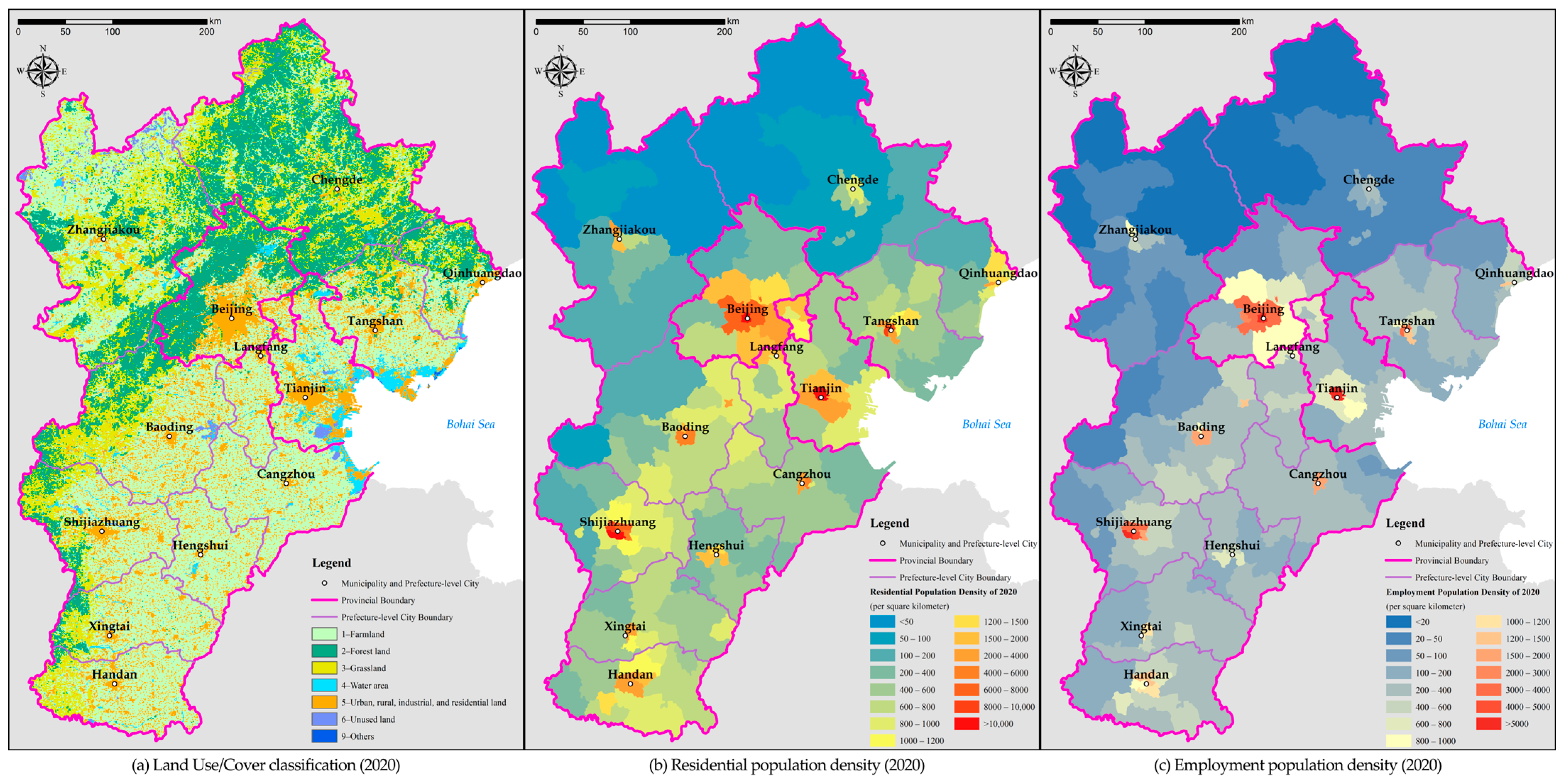
2.1. Study Area and Data
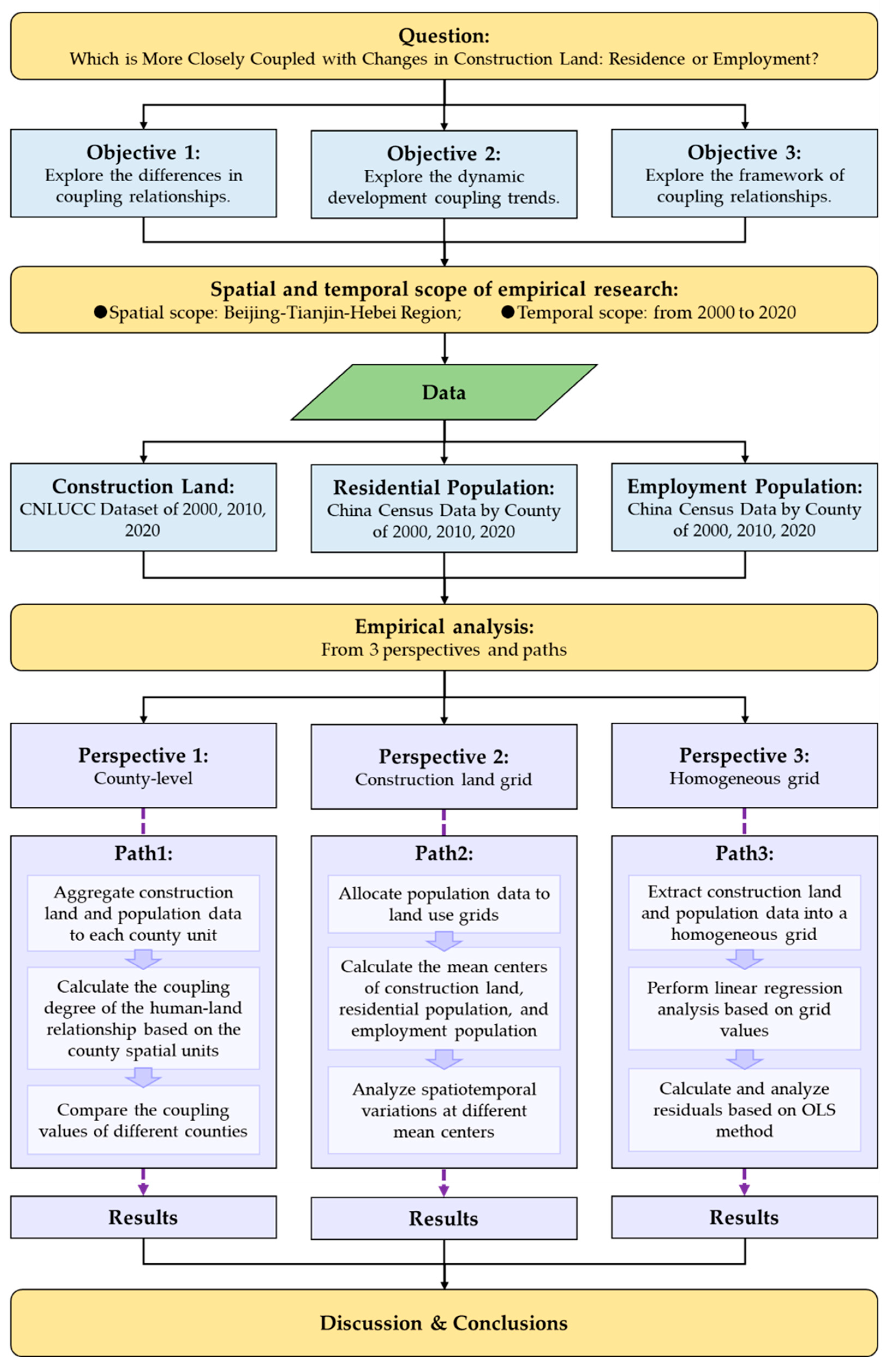
2.2. Methods
3. Results
3.1. Subsystem Coupling Analysis Based on County Spatial Units
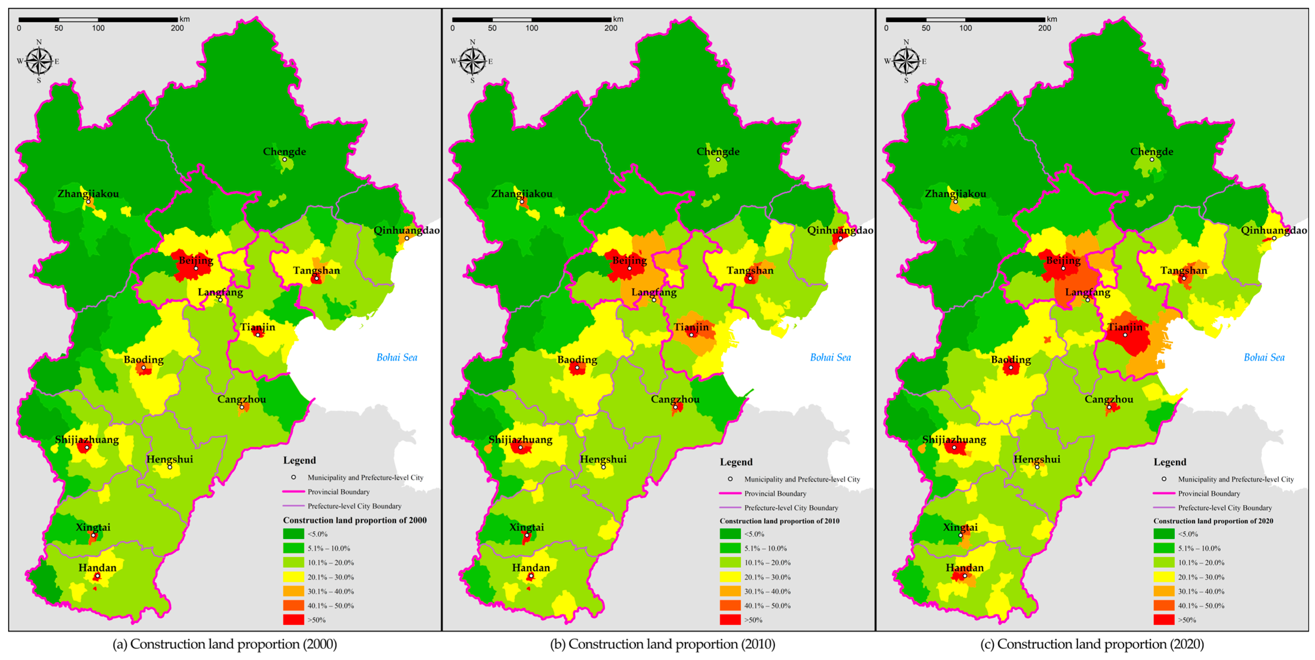
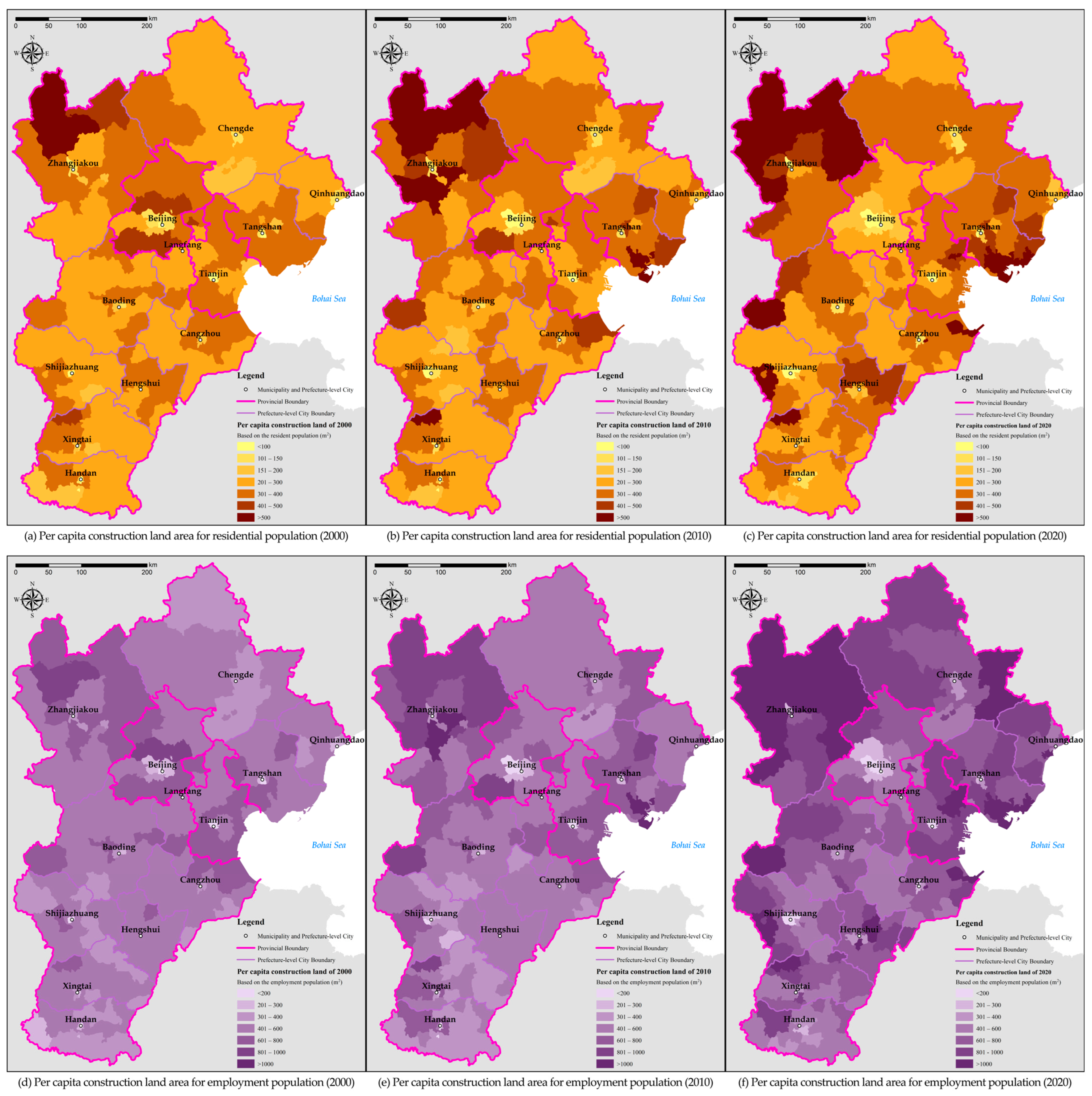
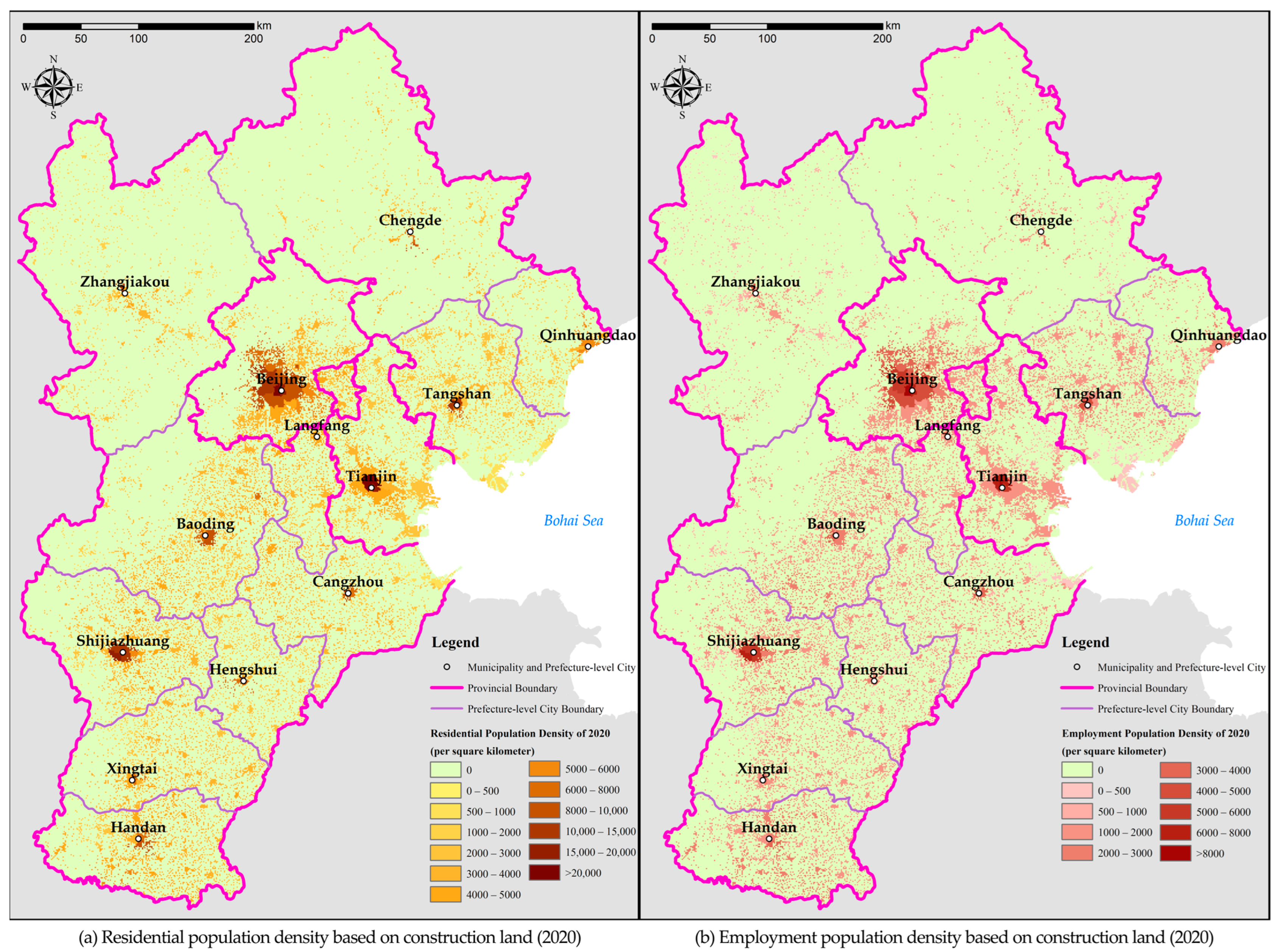
3.1.1. Subsystem Data Presentation Based on County Units
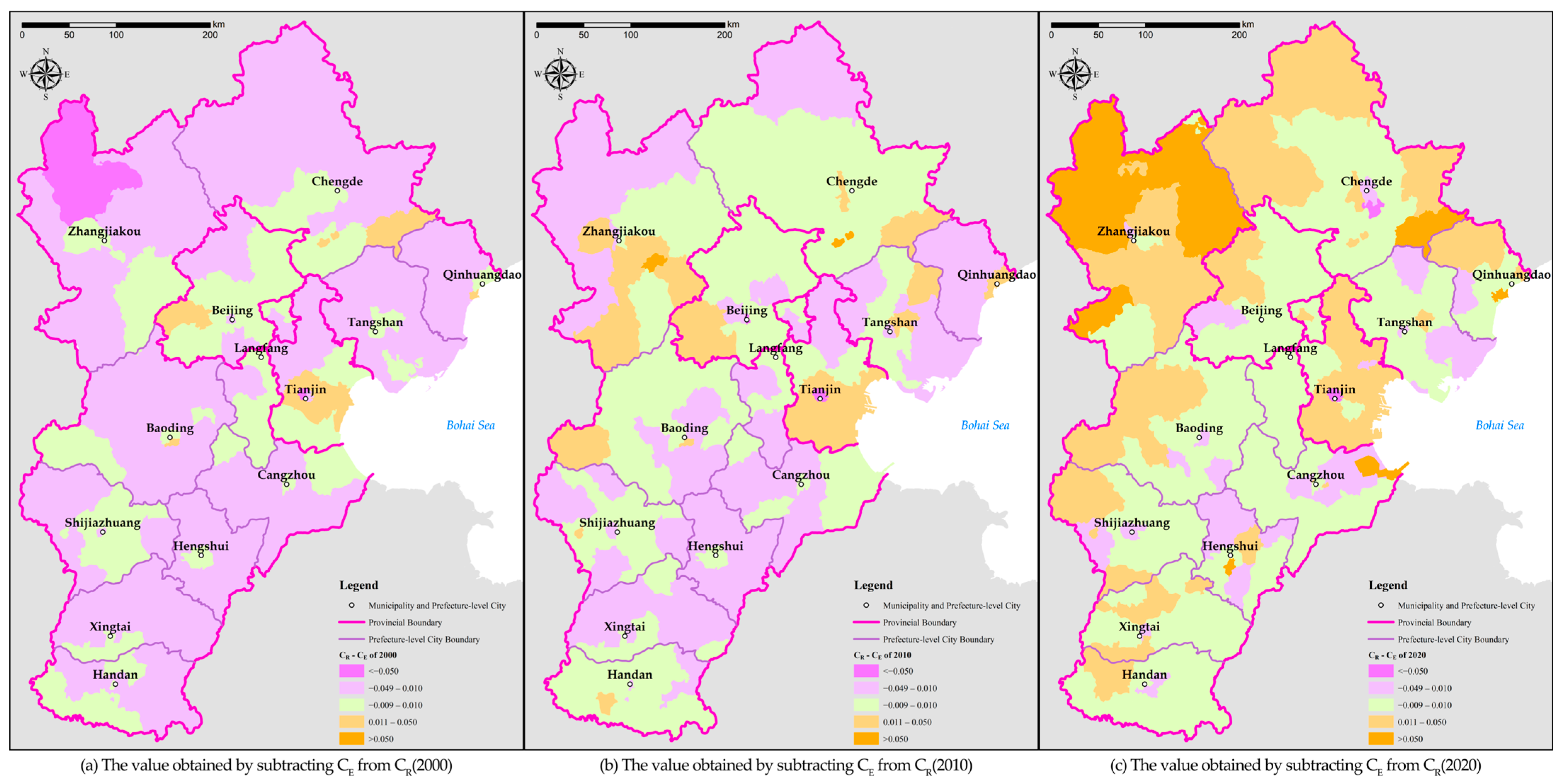
3.1.2. Analysis of Coupling between Subsystems
3.2. Changes in the Mean Center Positions Based on the Land Use Grids
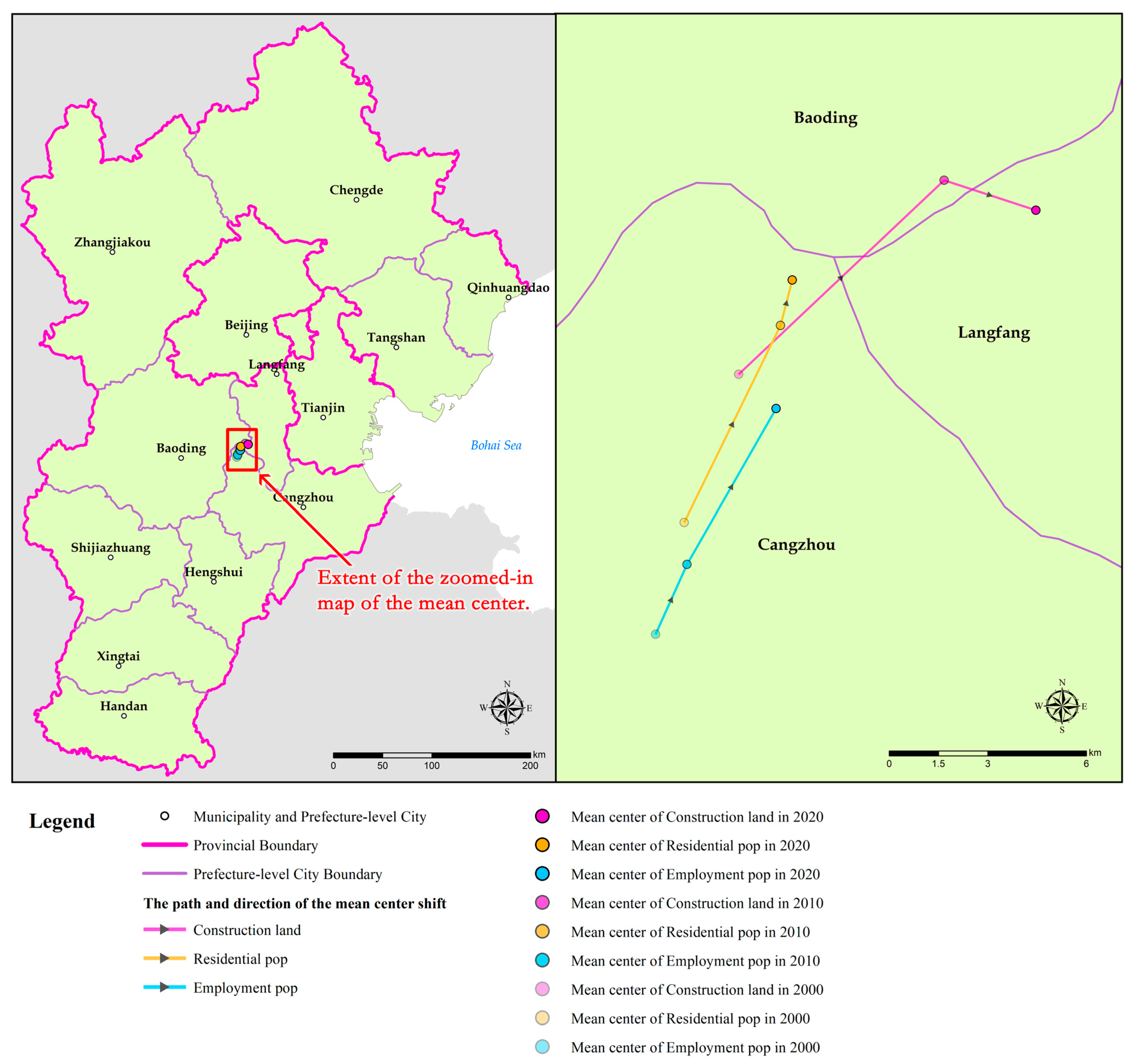
3.2.1. Mean Center Change Characteristics of the Entire BTH Region
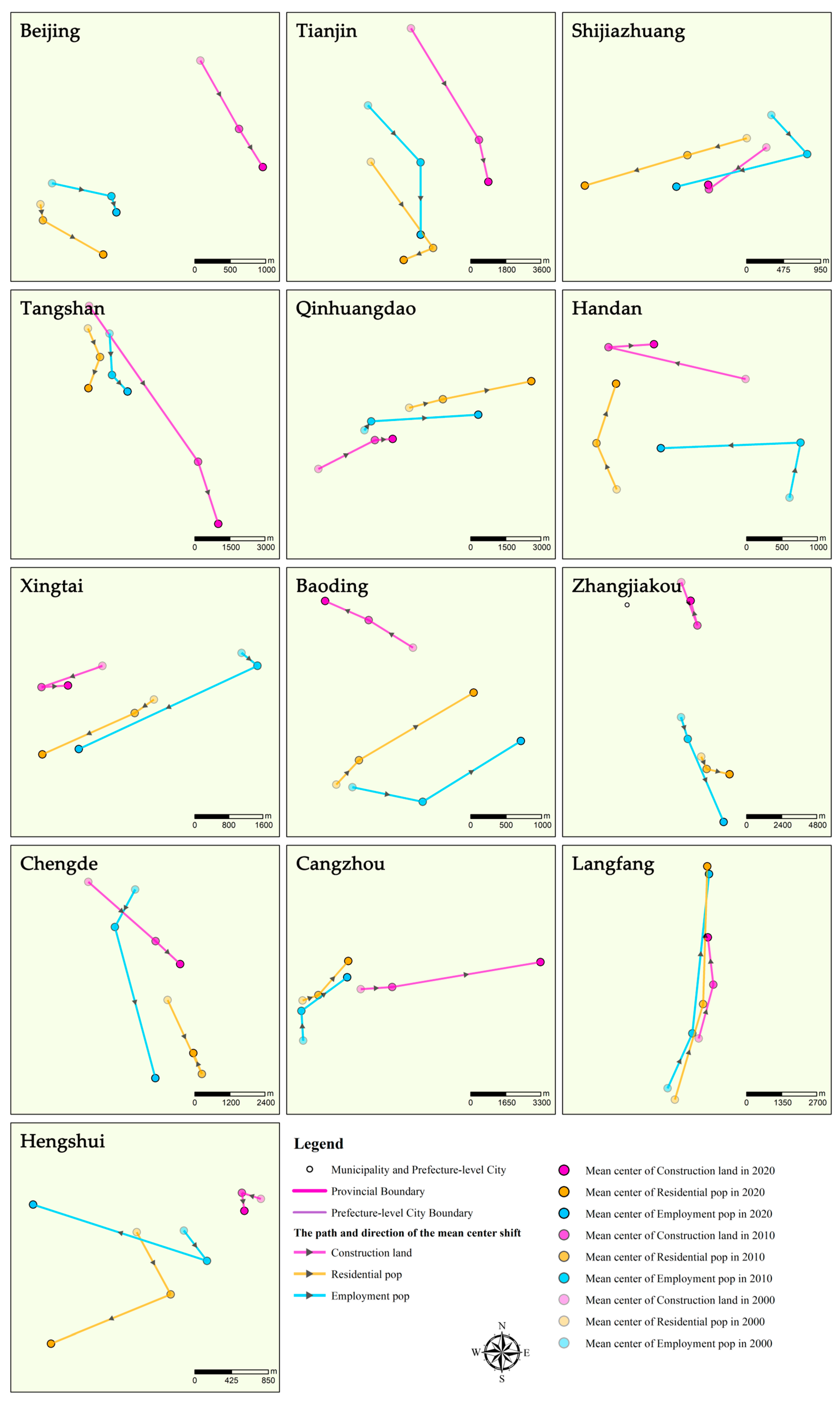
3.2.2. Mean Center Change Characteristics of the 13 Cities
3.3. Regression Analysis Based on Homogeneous Grids
3.3.1. Regression Analysis
3.3.2. Residual Analysis Based on the Method of Ordinary Least Squares
4. Discussion
4.1. The Coordination with Construction Land Varies, with Residential and Employment Populations Exhibiting a Trade-Off Relationship
4.2. The Key Measures to Improve the Coordination between Construction Land and Population Distribution
4.3. The Applicability of the Analysis Methods Used in This Study to Urban Planning and Decision-Making
5. Conclusions
Funding
Data Availability Statement
Conflicts of Interest
Appendix A
| Area | CR | CE | ||||
|---|---|---|---|---|---|---|
| 2000 | 2010 | 2020 | 2000 | 2010 | 2020 | |
| Total | 0.939 [0.748, 1.000] | 0.952 [0.622, 1.000] | 0.960 [0.601, 1.000] | 0.953 [0.808, 1.000] | 0.962 [0.649, 1.000] | 0.959 [0.663, 1.000] |
| Beijing | 0.911 [0.814, 1.000] | 0.923 [0.747, 0.996] | 0.949 [0.754, 1.000] | 0.918 [0.839, 1.000] | 0.933 [0.780, 0.992] | 0.948 [0.754, 1.000] |
| Tianjin | 0.901 [0.748, 0.990] | 0.892 [0.730, 0.989] | 0.884 [0.601, 1.000] | 0.918 [0.808, 0.983] | 0.920 [0.838, 0.976] | 0.918 [0.771, 0.995] |
| Shijiazhuang | 0.945 [0.806, 0.994] | 0.972 [0.923, 1.000] | 0.966 [0.836, 1.000] | 0.955 [0.820, 0.999] | 0.982 [0.932, 1.000] | 0.966 [0.855, 0.999] |
| Tangshan | 0.941 [0.897, 1.000] | 0.921 [0.622, 0.978] | 0.944 [0.761, 0.999] | 0.955 [0.916, 1.000] | 0.926 [0.649, 0.995] | 0.949 [0.752, 1.000] |
| Qinhuangdao | 0.964 [0.933, 1.000] | 0.965 [0.947, 0.999] | 0.982 [0.960, 0.999] | 0.976 [0.934, 1.000] | 0.965 [0.917, 0.989] | 0.977 [0.925, 0.999] |
| Handan | 0.968 [0.918, 1.000] | 0.979 [0.900, 1.000] | 0.991 [0.934, 1.000] | 0.981 [0.934, 1.000] | 0.987 [0.944, 0.999] | 0.992 [0.961, 1.000] |
| Xingtai | 0.955 [0.844, 0.998] | 0.972 [0.872, 0.997] | 0.984 [0.910, 1.000] | 0.971 [0.880, 0.999] | 0.985 [0.898, 0.999] | 0.979 [0.903, 1.000] |
| Baoding | 0.940 [0.898, 0.997] | 0.966 [0.912, 1.000] | 0.982 [0.918, 1.000] | 0.955 [0.906, 1.000] | 0.974 [0.877, 1.000] | 0.981 [0.875, 1.000] |
| Zhangjiakou | 0.927 [0.820, 1.000] | 0.923 [0.849, 0.997] | 0.913 [0.700, 1.000] | 0.946 [0.871, 0.999] | 0.921 [0.846, 1.000] | 0.880 [0.696, 0.991] |
| Chengde | 0.966 [0.933, 1.000] | 0.975 [0.956, 1.000] | 0.979 [0.927, 0.999] | 0.971 [0.943, 0.997] | 0.964 [0.913, 1.000] | 0.966 [0.926, 0.999] |
| Cangzhou | 0.951 [0.891, 0.991] | 0.975 [0.917, 1.000] | 0.958 [0.713, 1.000] | 0.967 [0.890, 0.988] | 0.985 [0.917, 0.999] | 0.955 [0.663, 1.000] |
| Langfang | 0.929 [0.872, 0.962] | 0.957 [0.895, 0.983] | 0.991 [0.964, 1.000] | 0.939 [0.889, 0.975] | 0.968 [0.922, 0.993] | 0.990 [0.946, 0.999] |
| Hengshui | 0.925 [0.893, 0.952] | 0.953 [0.928, 0.983] | 0.968 [0.934, 0.995] | 0.955 [0.924, 0.978] | 0.977 [0.965, 0.993] | 0.972 [0.923, 0.994] |
| Area | Distance between Mean Center of Construction Land and the Residential Population (m) | Distance between Mean Center of Construction Land and the Employment Population (m) | ||||
|---|---|---|---|---|---|---|
| 2000 | 2010 | 2020 | 2000 | 2010 | 2020 | |
| Beijing | 3036 | 3056 | 2569 | 2717 | 2037 | 2163 |
| Tianjin | 7153 | 6024 | 5910 | 4528 | 3210 | 4406 |
| Shijiazhuang | 276 | 518 | 1584 | 419 | 1341 | 409 |
| Tangshan | 967 | 6134 | 8033 | 1471 | 5225 | 6865 |
| Qinhuangdao | 4685 | 3397 | 6430 | 2576 | 818 | 3809 |
| Handan | 2395 | 1365 | 772 | 1786 | 3028 | 1470 |
| Xingtai | 1446 | 2275 | 1730 | 3290 | 5106 | 1515 |
| Baoding | 2210 | 1978 | 2461 | 2142 | 2671 | 3395 |
| Zhangjiakou | 11,986 | 9818 | 12147 | 9210 | 7772 | 15,282 |
| Chengde | 4867 | 4814 | 3078 | 1627 | 1475 | 3994 |
| Cangzhou | 2788 | 3499 | 9045 | 3632 | 4421 | 9124 |
| Langfang | 2532 | 848 | 2733 | 2264 | 2041 | 2437 |
| Hengshui | 1485 | 1432 | 2709 | 963 | 883 | 2442 |
| Average | 3525 | 3474 | 4554 | 2817 | 3079 | 4409 |
References
- Hasselmann, F.; Csaplovics, E.; Falconer, I.; Bürgi, M.; Hersperger, A.M. Technological driving forces of LUCC: Conceptualization, quantification, and the example of urban power distribution networks. Land Use Policy 2010, 27, 628–637. [Google Scholar] [CrossRef]
- Schirpke, U.; Leitinger, G.; Tappeiner, U.; Tasser, E. SPA-LUCC: Developing land-use/cover scenarios in mountain landscapes. Ecol. Inform. 2012, 12, 68–76. [Google Scholar] [CrossRef]
- Transforming Our World: The 2030 Agenda for Sustainable Development; United Nations: New York, NK, USA, 2015.
- Chen, C. Changes of the Current Chinese Urban and Rural Employment Space and Extended Discussion. City Plan. Rev. 2014, 38, 72–78. [Google Scholar]
- Shanghai Municipal People’s Government. Shanghai Master Plan (2017–2035); Shanghai Scientific & Technical Publishers: Shanghai, China, 2018. [Google Scholar]
- Liu, J.; Deng, X. Progress of the research methodologies on the temporal and spatial process of LUCC. Chin. Sci. Bull. 2009, 54, 3251–3258. [Google Scholar] [CrossRef]
- Olmedo Camacho, M.T.; Paegelow, M.; Mas, J.F.; Escobar, F. Geomatic Approaches for Modeling Land Change Scenarios. An Introduction; Springer International Publishing: Berlin/Heidelberg, Germany, 2018; pp. 1–8. [Google Scholar]
- Ruelland, D.; Tribotte, A.; Puech, C.; Dieulin, C. Comparison of methods for LUCC monitoring over 50 years from aerial photographs and satellite images in a Sahelian catchment. Int. J. Remote Sens. 2011, 32, 1747–1777. [Google Scholar] [CrossRef]
- Fang, X.; Zhao, W.; Zhang, C.; Zhang, D.; Wei, X.; Qiu, W.; Ye, Y. Methodology for credibility assessment of historical global LUCC datasets. Sci. China Earth Sci. 2020, 63, 1013–1025. [Google Scholar] [CrossRef]
- Mazy, F.R.; Longaretti, P.Y. Towards a generic theoretical framework for pattern-based LUCC modeling: An accurate and powerful calibration–estimation method based on kernel density estimation. Environ. Model. Softw. 2022, 158, 105551. [Google Scholar] [CrossRef]
- Li, X.; Chen, G.; Liu, X.; Liang, X.; Wang, S.; Chen, Y.; Pei, F.; Xu, X. A New Global Land-Use and Land-Cover Change Product at a 1-km Resolution for 2010 to 2100 Based on Human-Environment Interactions. Ann. Am. Assoc. Geogr. 2017, 107, 1040–1059. [Google Scholar] [CrossRef]
- García-Álvarez, D.; Camacho Olmedo, M.T.; Paegelow, M. Sensitivity of a common Land Use Cover Change (LUCC) model to the Minimum Mapping Unit (MMU) and Minimum Mapping Width (MMW) of input maps. Comput. Environ. Urban Syst. 2019, 78, 101389. [Google Scholar] [CrossRef]
- García-Álvarez, D.; Lloyd, C.D.; Van Delden, H.; Camacho Olmedo, M.T. Thematic resolution influence in spatial analysis. An application to Land Use Cover Change (LUCC) modelling calibration. Comput. Environ. Urban Syst. 2019, 78, 101375. [Google Scholar] [CrossRef]
- García-Álvarez, D.; Camacho Olmedo, M.T.; Van Delden, H.; Mas, J.; Paegelow, M. Comparing the structural uncertainty and uncertainty management in four common Land Use Cover Change (LUCC) model software packages. Environ. Model. Softw. 2022, 153, 105411. [Google Scholar] [CrossRef]
- Ul Din, S.; Mak, H.W.L. Retrieval of Land-Use/Land Cover Change (LUCC) Maps and Urban Expansion Dynamics of Hyderabad, Pakistan via Landsat Datasets and Support Vector Machine Framework. Remote Sens. 2021, 13, 3337. [Google Scholar] [CrossRef]
- Liu, J.; Kuang, W.; Zhang, Z.; Qin, Y.; Ning, J.; Zhou, W.; Zhang, S.; Li, R.; Yan, C.; Wu, S.; et al. Spatiotemporal characteristics, patterns and causes of land use changes in China since the late 1980s. Acta Geogr. Sin. 2014, 69, 3–14. [Google Scholar] [CrossRef]
- Luo, K.; Zhang, X. Increasing urban flood risk in China over recent 40 years induced by LUCC. Landsc. Urban Plan. 2022, 219, 104317. [Google Scholar] [CrossRef]
- Wang, J.; Zhao, L.; Wu, H.; Dong, X.; Cao, Z.; Ma, M. Urbanization Magnifies Spatial Variations of Local Meteorological Conditions in Southwest China. Mt. Res. 2022, 40, 120–135. [Google Scholar]
- Li, C.; Zhang, Y.; Shen, Y.; Kong, D.; Zhou, X. LUCC-Driven Changes in Gross Primary Production and Actual Evapotranspiration in Northern China. J. Geophys. Res. Atmos. 2020, 125, e2019JD031705. [Google Scholar] [CrossRef]
- Liu, J.; Xu, X.; Zhuang, D.; Gao, Z. Impacts of LUCC processes on potential land productivity in China in the 1990s. Sci. China Ser. D Earth Sci. 2005, 48, 1259–1269. [Google Scholar] [CrossRef]
- Wei, W.; Xia, J.; Hong, M.; Bo, L. The Evolution of “Three-Zone Space” in the Yangtze River Economic Belt under Major Functional Zoning Strategy from 1980 to 2018. Urban Plan. Forum 2021, 28–35. [Google Scholar]
- Marelli, E. Evolution of Employment Structures and Regional Specialisation in the EU. Econ. Syst. 2004, 28, 35–59. [Google Scholar] [CrossRef]
- Zhenbo, W.; Chuangeng, Z. Employment Spatial Models and Regionalization of China. Acta Geogr. Sin. 2007, 62, 191–199. [Google Scholar]
- Ge, M.; Feng, Z. Classification of densities and characteristics of curve of population centers in China by GIS. J. Geogr. Sci. J. Geogr. Sci 2010, 20, 628–640. [Google Scholar] [CrossRef]
- Shearmur, R.; Coffey, W.J. A Tale of Four Cities: Intrametropolitan Employment Distribution in Toronto, Montreal, Vancouver, and Ottawa-Hull, 1981–1996. Environ. Plan. A Econ. Space 2002, 34, 575–598. [Google Scholar] [CrossRef]
- Alidadi, M.; Dadashpoor, H. Beyond Monocentricity: Examining the Spatial Distribution of Employment in Tehran Metropolitan Region, Iran. Int. J. Urban Sci. 2018, 22, 38–58. [Google Scholar] [CrossRef]
- Wu, S.; Qiu, X.; Wang, L. Population Estimation Methods in GIS and Remote Sensing: A Review. GIScience Remote Sens. 2005, 42, 80–96. [Google Scholar] [CrossRef]
- Wang, B.; Wang, L.; Liu, Y.; Yang, B.; Huang, X.; Yang, M. Characteristics of jobs-housing spatial distribution in Beijing based on mobile phone signaling data. Prog. Geogr. 2020, 39, 2028–2042. [Google Scholar] [CrossRef]
- Desmet, K.; Fafchamps, M. Changes in the Spatial Concentration of Employment across US Counties: A Sectoral Analysis 1972–2000. J. Econ. Geogr. 2005, 5, 261–284. [Google Scholar] [CrossRef]
- Guillain, R.; Le Gallo, J.; Boiteux-Orain, C. Changes in Spatial and Sectoral Patterns of Employment in Ile-de-France, 1978–1997. Urban Stud. 2006, 43, 2075–2098. [Google Scholar] [CrossRef]
- Dongsheng, Z.; Wenzhong, Z.; Bin, M.; Yunxiao, D.; Qianqian, L. Spatial Structure of Urban Residence and Employment in Beijing. Sci. Geogr. Sin. 2017, 37, 356–366. [Google Scholar]
- Huafu, J.; Jing, H. Spatial Match Between Employment and Housing in Wuhu City, Anhui Province of China. Sci. Geogr. Sin. 2011, 31, 788–793. [Google Scholar]
- Ye, D. The interactive mechanism of man-earth areal system and the sustainable development. Geogr. Res. 2001, 20, 307–314. [Google Scholar]
- Liu, H.; Fang, C.; Li, Y. The Coupled Human and Natural Cube: A conceptual framework for analyzing urbanization and eco-environment interactions. Acta Geogr. Sin. 2019, 74, 1489–1507. [Google Scholar]
- Xu, Y.; Xu, X.; Tang, Q. Human activity intensity of land surface: Concept, methods and application in China. J. Geogr. Sci. 2016, 26, 1349–1361. [Google Scholar] [CrossRef]
- Zhu, C.; Zhang, X.; Wang, K.; Yuan, S.; Yang, L.; Skitmore, M. Urban–rural construction land transition and its coupling relationship with population flow in China’s urban agglomeration region. Cities 2020, 101, 102701. [Google Scholar] [CrossRef]
- Qu, Y.; Jiang, G.; Tian, Y.; Shang, R.; Wei, S.; Li, Y. Urban—Rural construction land Transition (URCLT) in Shandong Province of China: Features measurement and mechanism exploration. Habitat Int. 2019, 86, 101–115. [Google Scholar]
- Li, Y.; Kong, X.; Zhu, Z. Multiscale analysis of the correlation patterns between the urban population and construction land in China. Sustain. Cities Soc. 2020, 61, 102326. [Google Scholar] [CrossRef]
- Wu, Y.; Liu, Y.; Li, Y. Spatio-temporal coupling of demographic-landscape urbanization and its driving forces in China. Acta Geogr. Sin. 2018, 73, 1865–1879. [Google Scholar]
- Liu, J.; Liu, Y.; Li, Y.; Hu, Y. Coupling Analysis of Rural Residential Land and Rural Population in China during 2007–2015. J. Nat. Resour. 2018, 33, 1861–1871. [Google Scholar]
- Yan, Z.; Xianjin, H.; Guoliang, X.; Jianbao, L. The coupling and driving forces between urban land expansion and population growth in Yangtze River Delta. Geogr. Res. 2016, 35, 313–324. [Google Scholar]
- Cheng, Y.; Ren, J.; Xu, C. Men-land Relationship’s Evolution Trend and Influence Factor of Shandong Province from the Perspective of Ecological Civilization. China Popul. Resour. Environ. 2015, 25, 121–127. [Google Scholar]
- Sun, P.; Xiu, C. Coupling Degree Assessment of the Man-Land Coupling System of the Mining City from the Vulnerability Perspective. Areal Res. Dev. 2010, 29, 75–79. [Google Scholar]
- Gan, C.; Li, Y.; Chen, M. Man-land relationship of Fengjie county in the Three Gorges Reservoir Area based on coupling comparison of sloping cultivated lands and settlements. Geogr. Res. 2015, 34, 1259–1269. [Google Scholar]
- Bajocco, S.; De Angelis, A.; Perini, L.; Ferrara, A.; Salvati, L. The Impact of Land Use/Land Cover Changes on Land Degradation Dynamics: A Mediterranean Case Study. Environ. Manag. 2012, 49, 980–989. [Google Scholar] [CrossRef] [PubMed]
- Luan, F.; Xiong, H.; Wang, F.; Li, D.; Wang, Z.; Tian, Y. Analysis on LUCC and Social Human Driving Factors of Typical Oasis City in Arid Areas—A Case of Urumqi City. Resour. Dev. Mark. 2014, 30, 265–270. [Google Scholar]
- Ge, Q.; Fang, C.; Jiang, D. Geographical missions and coupling ways between human and nature for the Beautiful China Initiative. Acta Geogr. Sin. 2020, 75, 1109–1119. [Google Scholar]
- Lv, F.; Mai, J.; Wang, Y.; Jiang, C.; Yang, Y.; Wang, B. Multi-scale Analysis on the Spatio-temporal Evolution of Urban Agglomerations in the Guangdong-Hong Kong-Macao Greater Bay Area. Trop. Geomorphol. 2020, 41, 27–37. [Google Scholar]
- Yang, L.; Wang, J.; Zhou, W. Coupling evolution analysis of LUCC and habitat quality in Dongting Lake Basin Based on multi-scenario simulation. China Environ. Sci. 2023, 43, 863–873. [Google Scholar]
- Xu, X.; Liu, J.; Zhang, S.; Li, R.; Yan, C.; Wu, S. China’s Multi-Period Land Use Land Cover Remote Sensing Monitoring Data Set (CNLUCC); Data Registration and Publication System of Resource and Environmental Science Data Center, Chinese Academy of Sciences: Beijing, China, 2018. [Google Scholar]
- Office of the Leading Group of the State Council for the Seventh National Population Census. Tabulation on 2020 China Population Census by County; China Statistics Press: Beijing, China, 2022. [Google Scholar]
- Population Census Office under the State Council; Department of Populationand Employment Statistics, National Bureau of Statistics. Tabulation on the 2010 Population Census of the People’s Republic of China by County; China Statistics Press: Beijing, China, 2012. [Google Scholar]
- Population Census Office under the State Council; Department of Population and Social Science and Technology Statistics, National Bureau of Statistics. Tabulation on the 2010 Population Census by County; China Statistics Press: Beijing, China, 2003. [Google Scholar]
- Wang, S.; Kong, W.; Ren, L.; Zhi, D.; Dai, B. Research on misuses and modification of coupling coordination degree model in China. J. Nat. Resour. 2021, 36, 793–810. [Google Scholar] [CrossRef]



Disclaimer/Publisher’s Note: The statements, opinions and data contained in all publications are solely those of the individual author(s) and contributor(s) and not of MDPI and/or the editor(s). MDPI and/or the editor(s) disclaim responsibility for any injury to people or property resulting from any ideas, methods, instructions or products referred to in the content. |
© 2024 by the author. Licensee MDPI, Basel, Switzerland. This article is an open access article distributed under the terms and conditions of the Creative Commons Attribution (CC BY) license (https://creativecommons.org/licenses/by/4.0/).
Share and Cite
Chen, C. Coupling between Population and Construction Land Changes in the Beijing–Tianjin–Hebei (BTH) Region: Residential and Employment Perspectives. Systems 2024, 12, 308. https://doi.org/10.3390/systems12080308
Chen C. Coupling between Population and Construction Land Changes in the Beijing–Tianjin–Hebei (BTH) Region: Residential and Employment Perspectives. Systems. 2024; 12(8):308. https://doi.org/10.3390/systems12080308
Chicago/Turabian StyleChen, Chen. 2024. "Coupling between Population and Construction Land Changes in the Beijing–Tianjin–Hebei (BTH) Region: Residential and Employment Perspectives" Systems 12, no. 8: 308. https://doi.org/10.3390/systems12080308
APA StyleChen, C. (2024). Coupling between Population and Construction Land Changes in the Beijing–Tianjin–Hebei (BTH) Region: Residential and Employment Perspectives. Systems, 12(8), 308. https://doi.org/10.3390/systems12080308


