Article

Exploring Ecological Management Plans for Typical Systems in Arid Areas from the Perspective of Ecosystem Service Value Evolution

1
College of Geography and Environmental Science, Northwest Normal University, Lanzhou 730070, China
2
Key Laboratory of Resource Environment and Sustainable Development of Oasis, Lanzhou 730070, China
3
Gansu Engineering Research Center of Land Utilization and Comprehension Consolidation, Lanzhou 730070, China
*
Author to whom correspondence should be addressed.
Systems 2024, 12(5), 166; https://doi.org/10.3390/systems12050166
Submission received: 14 March 2024 / Revised: 2 May 2024 / Accepted: 6 May 2024 / Published: 8 May 2024

Abstract

:
Ecological management zoning plays a significant role in optimizing resource utilization, improving ecosystem service function, and promoting coordinated regional development. Taking Hexi Corridor as a representative region of the Mountain–Oasis–Desert composite system in arid regions of Asia, this study analyzed the spatial and temporal evolution of ecosystem service values and explored the influencing mechanism based on the optimal parameters-based geographical detector model. We have comprehensively divided ecological management zones and proposed corresponding control strategies. The results show that (1) the Hexi Corridor is characterized by regional differentiation, which is composed of three systems: The southern mountain system, central oasis system, and northern desert system. The mountain system is mainly composed of forestland and grassland, the oasis system is mainly composed of cropland, and the desert system is mainly composed of unused land. The conversion of land use mainly involves the conversion of unused land to cropland and grassland, while grassland is mainly converted to cropland. (2) The ecosystem service value of the Hexi Corridor increased significantly and demonstrated agglomeration characteristics in space. The highest value areas are mainly distributed in the southern mountain, with higher value and medium areas mainly distributed in the central oasis, and the lowest value areas are mainly located in the northern desert. (3) Socio-economic factors greatly influence the spatial differentiation of ecosystem service values in the Hexi Corridor, with natural environmental factors having less impact. Additionally, the internal interaction of natural environmental factors is the most significant. (4) The Hexi Corridor is divided into three ecological management zones: Ecological function protection zone, ecological and agricultural coordinated development zone, and ecological and urbanization coordinated development zone. This research has important reference value for global ecological management in arid regions.

1. Introduction

Ecosystems provide numerous beneficial services to human society, including regulation of water resources, soil conservation, carbon storage, and maintenance of biodiversity. In arid regions, these services are particularly significant because they are directly related to the region’s water resource security, environmental stability, and the quality of residents’ livelihoods [1,2]. Since the beginning of the Anthropocene, human activities have increasingly interfered with the environment, thereby affecting ecosystem composition and system function [3]. With the impact of climate change and human activities, the ecosystem service value of arid areas has undergone changes. These changes may result in the increase or decrease of certain ecosystem services, affecting the ecological balance and economic development of the region. Particularly with the continuous advancement of urbanization and industrialization, scientific and reasonable ecological management interventions in ecologically important but environmentally fragile areas have become increasingly urgent [4]. In order to address the changes in the ecosystem of arid areas, it is necessary to develop effective ecological management plans. These plans should aim to maintain or restore the provision of ecosystem services while considering the needs of economic and social development. From the perspective of ecosystem service functions, assessing the value of ecosystem services, clarifying the value evolution and spatial characteristics of different services, and then conducting comprehensive zoning and guiding the implementation of policies are crucial steps in ecological management.
Currently, there are three main methods for ecosystem service valuation. The first method is the energy value assessment, which calculates the energy value conversion rate of different forms of matter and energy, using solar energy as the common unit, to assess the ecosystem services [5,6]. The second method is the value quantity assessment, which quantitatively assesses the services provided by ecosystems using monetary values and presents the assessment results in monetary quantities [7,8]. The third is the physical quality assessment, which mainly utilizes models such as InVEST and SoLVES to simulate the quality of ecosystem services based on data inputs and parameter settings and then quantitatively assesses the strength of ecosystem service provision [9,10]. Among those methods, the value quantity assessment method has the advantages of simple measurement, a more comprehensive assessment of ecosystem service functions, and greater applicability to ecosystem service valuation at larger scales, making it widely used.
Ecological management zoning aims to demarcate distinct management areas by considering the ecological characteristics and needs of a region, thereby enabling targeted protection of the ecological environment [11,12]. Current research in ecological management zoning is largely informed by two distinct perspectives. The first involves zoning based on different research objects, which encompasses various study types, such as wetlands [13,14], protected areas [15,16], agricultural land [17,18], etc. The second perspective entails zoning based on different research contents, partitioning from the vantage point of hotspot topics, including ecosystem service supply and demand [19,20], ecosystem service clusters [21], ecosystem service value and ecological risk assessment [22,23], etc. Zoning scales are varied, typically spanning regional, provincial, county, and type units. Predominantly, existing research in ecological management zoning concentrates on significant watersheds and economically advanced regions [24,25] but pays less attention to areas with harsh climatic and environmental conditions and lagging economic development, particularly the typical Mountain–Oasis–Desert composite system in arid regions. In particular, fewer studies have been conducted on the typical Mountain–Oasis–Desert composite system in arid regions. Notably, these typical systems in arid regions are subject to the dual constraints of a fragile ecological environment and lagging economic progress [26]. Therefore, the study of ecological management zones can potentially exacerbate the integrated development of these systems, leading to the optimal allocation of resources and maximization of overall benefits. The Mountain–Oasis–Desert composite system is a typical ecologically fragile area in an arid region. As a typical area, the Hexi Corridor is not only an important part of the ancient Silk Road but also an important implementation area of the “Belt and Road” construction. This study aims to explore the temporal and spatial evolution characteristics of ecosystem service value in the Hexi Corridor from 1980 to 2020. It focuses on identifying key areas where ecosystem service value has been gained or lost, as well as addressing the main ecological issues by proposing corresponding ecological management strategies. The study consists of four main components: (1) Constructing an evaluation model for ecosystem service value in the Hexi Corridor; (2) analyzing the temporal and spatial evolution characteristics of land use in the Hexi Corridor from 1980 to 2020; (3) examining the temporal and spatial evolution of ecosystem service value in the Hexi Corridor during the same period; (4) identifying and dividing ecological management areas, and offering targeted ecological management strategies. The findings of this study possess ample representation from both a research perspective and the typicality of selected cases, enabling their use as vital references for ecological management and control in arid regions worldwide.

2. Materials and Methods

2.1. Typical System Models and Ecological Vulnerability in Arid Areas

The Hexi Corridor, located in the arid inland areas of western China, features a typical arid and semi-arid climate and a fragile ecological environment. Due to the unique geographical environment, a typical arid area ecosystem has developed, comprising two subsystems: Natural system and social system, each with different ecological vulnerability mechanisms (Figure 1).
The natural system has a typical ecological pattern of “Mountain–Oasis–Desert”, and the distribution pattern of ecological vulnerability is shown in Figure 1a. High-altitude mountainous areas exhibit reduced biodiversity with a single vegetation type, resulting in high ecological vulnerability. The oasis area, with significantly low levels of overall ecological vulnerability, comprises a densely populated area featuring activities such as farmland cultivation and afforestation, which significantly improve the local ecosystem. The desert area is mainly influenced by natural ecological processes, and though vegetation is scarce, the desert regions exhibit relatively stable conditions with moderate ecological vulnerability in comparison to high-altitude mountainous and oasis areas. The social system has a typical spatial pattern of “urban area–rural area–natural area”, and the distribution pattern of ecological vulnerability is shown in Figure 1b. The terrain in this area is relatively flat, and the ecological vulnerability is mainly affected by social and economic factors. The urban fringe and urban–rural transition zone reflect the evolution process of urban expansion and rural settlements, and the ecological vulnerability is relatively high due to strong interference. Rural and natural areas exhibit few socio-economic activities, with ecological vulnerability showing a gradient weakening feature from rural area to rural natural transition zones, followed by natural areas.
In conclusion, for achieving sustainable development of typical systems in arid regions, human intervention in ecosystem management is crucial, particularly in areas such as zoning management, classified policy implementation, and graded protection. Our research work holds significant relevance in this regard.

2.2. Study Area

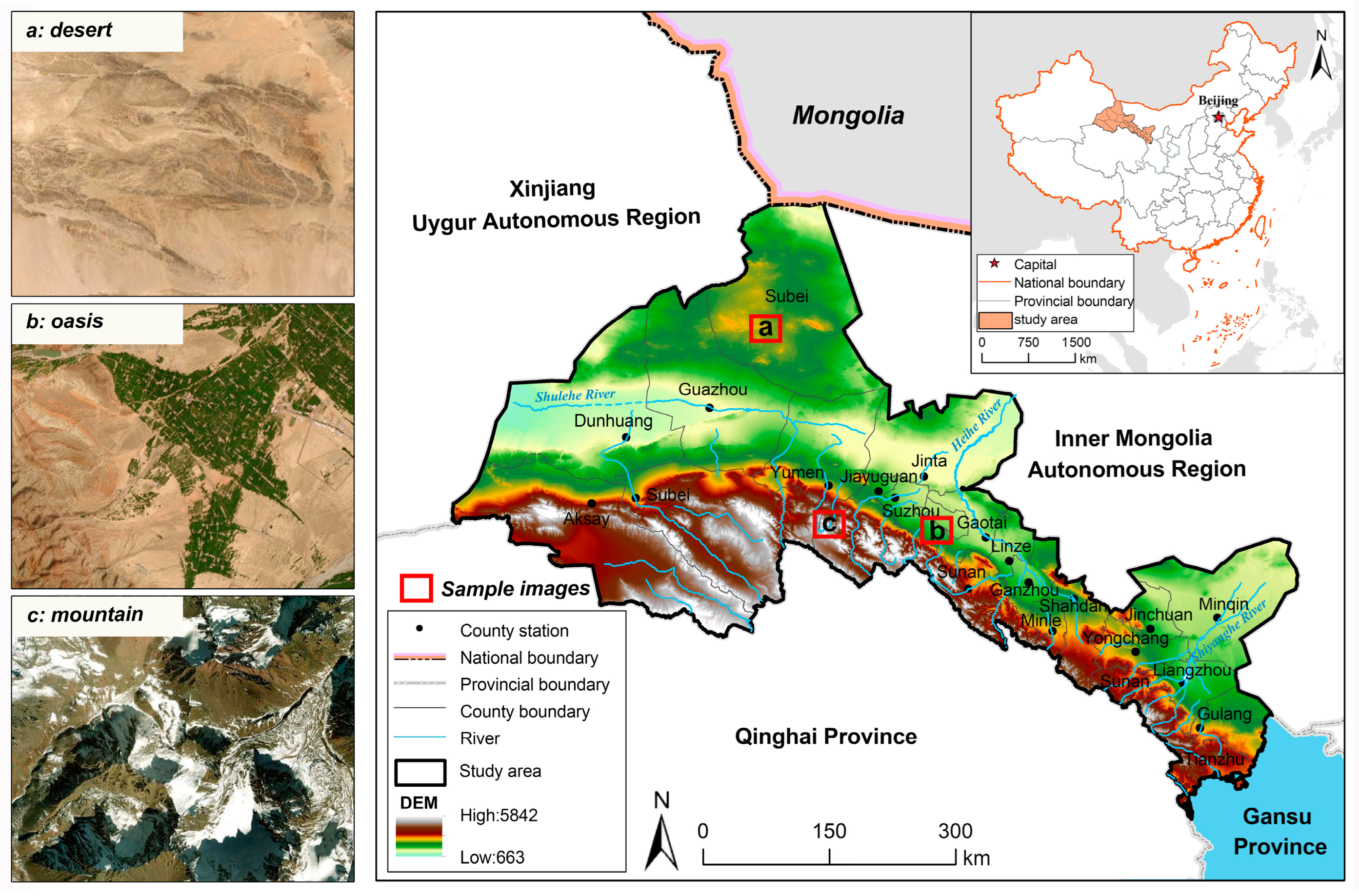
The Hexi Corridor is located to the west of the Yellow River in Gansu Province, between 37°17′~42°48′ N and 93°23′~104°12′ E, with a total administrative area of 2.71 × 10⁵ km2, and more than 54% of the unused land area, such as desert and the Gobi, with a very fragile ecological environment [27,28] (Figure 2). By the end of 2021, the five cities in the Hexi Corridor had a resident population of 4,369,700, with an urbanization rate of 59.76%. The Hexi Corridor is located in the arid and semi-arid transition zone, with a dry climate, low precipitation, scarce water resources, and high ecological sensitivity [29]. With the accelerating urbanization process in recent years, the Hexi Corridor is facing new and old ecological problems, and the tasks of desertification prevention and control, water resources conservation and utilization, water conservation, and biodiversity protection are arduous. The Hexi Corridor is not only an important part of the ancient Silk Road but also an important implementation area of the “Belt and Road” construction, which is an important link between China and Southeast Asia, Central Asia, and Europe in terms of trade and cultural exchanges [30].

2.3. Data Sources

The land-use data of the Hexi Corridor were obtained from the Resource and Environment Science and Data Center of the Chinese Academy of Sciences (https://www.resdc.cn, accessed on 5 January 2022), and the data of 1980, 2000, and 2020 from the China Multi-Period Land Use Remote Sensing Monitoring dataset were selected [31]. The average grain output was calculated from the total grain output and the sown area of grain crops, and the statistical data were obtained from the Gansu Statistical Yearbook, Gansu Yearbook, Gansu Development Yearbook, and the average grain price in 2020 was obtained from the State Administration of Grain and Material Reserves (http://www.lswz.gov.cn, accessed on 5 December 2022). The average annual temperature, average annual precipitation, and elevation of the Hexi Corridor were obtained from the Center for Resource and Environmental Science and Data of the Chinese Academy of Sciences (https://www.resdc.cn, accessed on 5 February 2022).

2.4. Models for Valuing Ecosystem Services

The value equivalent represents the value of ecosystem service per unit area of land. In this study, the value equivalent is expressed in “CNY *yuan/hm2”. This study mainly refers to the national ecosystem service value equivalent calculated by Xie et al. [32]. Due to regional differences, it is necessary to select the appropriate correction factors to revise the national ecosystem service value equivalent. The revised results are applicable to the study area. Referencing related research, net primary productivity (NPP) of vegetation, precipitation (PRE), and vegetation cover (FVC) are credible factors for revising the ecosystem service value equivalent. In the natural state, the value of ecosystem services per unit area is 1/7 of the existing economic value of food provision per unit area [33]. In 1980, 2000, and 2020, the average grain yield in the Hexi Corridor was 3.22 × 10⁴ kg/hm2. Using the average grain price of CNY 2.25 yuan/kg in 2020 as the unified calculation standard, and based on the research by Xie Gaodi et al. [32], the unit area ecosystem service value equivalent can be calculated to obtain the ecosystem service equivalent (E) for the Hexi Corridor region as CNY 1.03 × 10⁴ yuan/hm2 (Table 1).
E S V t = i = 1 n j = 1 m A i · E i j · R j k
R j k = ( N P P k N P P m e a n + P R E k P R E m e a n + F V C k F V C m e a n ) / 3
where E S V t represents the value of ecosystem services in each county; n and m denote land use categories and ecosystem service function categories, respectively. A i is the area of ecosystem type i in the grid; E i j is the unit value of ecosystem service function of ecosystem type j in ecosystem type i . R j k is the correction factor of ecosystem service value equivalent. N P P k , P R E k , and F V C k are the factor means of the research units, respectively. The N P P m e a n , P R E m e a n , and F V C m e a n denote the overall factor mean, respectively.

2.5. Spatial Autocorrelation Analysis

Spatial autocorrelation analysis is a commonly employed method to unveil spatial dependence and heterogeneity among research objects [34]. In this study, Global Moran’s I was used to determine whether there was spatial autocorrelation of ecosystem service values in the Hexi Corridor. Subsequently, Local Moran’s I was used to clarify the spatial clustering and distribution characteristics of high or low values. The calculation formula is as follows:
I = n k = 1 n l = 1 n W k l ( x k x ¯ ) ( x l x ¯ ) k = 1 n l = 1 n W k l k = 1 n ( x k x ¯ ) 2
I k = n ( x k x ¯ ) l = 1 n W k l ( x l x ¯ ) 2 k = 1 n ( x k x ¯ ) 2
Z I = I E I V a r I
where I and I k represents the global Moran’s I and local Moran’s I, respectively, x k and x l represents the evaluation results of ecosystem service value corresponding to research units k and l , respectively, W k l represents the measure of the relationship between the two. Z I is used to test the significance level of spatial autocorrelation, and E I and V a r I are the corresponding expectations and variances.

2.6. The Optimal Parameters-Based Geographical Detector Model

Geo-detector is an effective method to detect spatial differentiation features and their influence mechanisms, and it is widely used in many current studies [35]. Determining the best spatial stratification of spatial data is the key application link of geographical detectors. According to the q-value of geographical detection, the classification effect of data discretization can be accurately evaluated. The classification effect is proportional to the q-value. By using the GD package in R language and comprehensively using the natural breakpoint classification, geometric interval classification, equal interval classification, Quantile classification, and standard deviation classification, set the classification levels to 3~7, and finally select the spatial scale with the largest q-value as the analysis parameter of the geographical detector [36,37]. The expression formula is as follows:
q = 1 h = 1 L N h σ h 2 N σ 2 = 1 S S W S S T
S S W = h = 1 L N h σ h 2 ,   S S T = N σ 2
where q value represents the explanatory power of the factor, and 0 q 1 . When q = 1 , the explanatory power of the dependent variable is strongest; h represents the hierarchical number of the explanatory variable and the dependent variable; N h and σ h represent the number and variance of units in the h layer, N and σ 2 represent the number of units and variance of Y values in the entire region, respectively. S S W and S S T represent the sum of variance within the hierarchy and the total variance of the entire region, respectively.

3. Results

3.1. Land Use Patterns and Spatial and Temporal Evolution

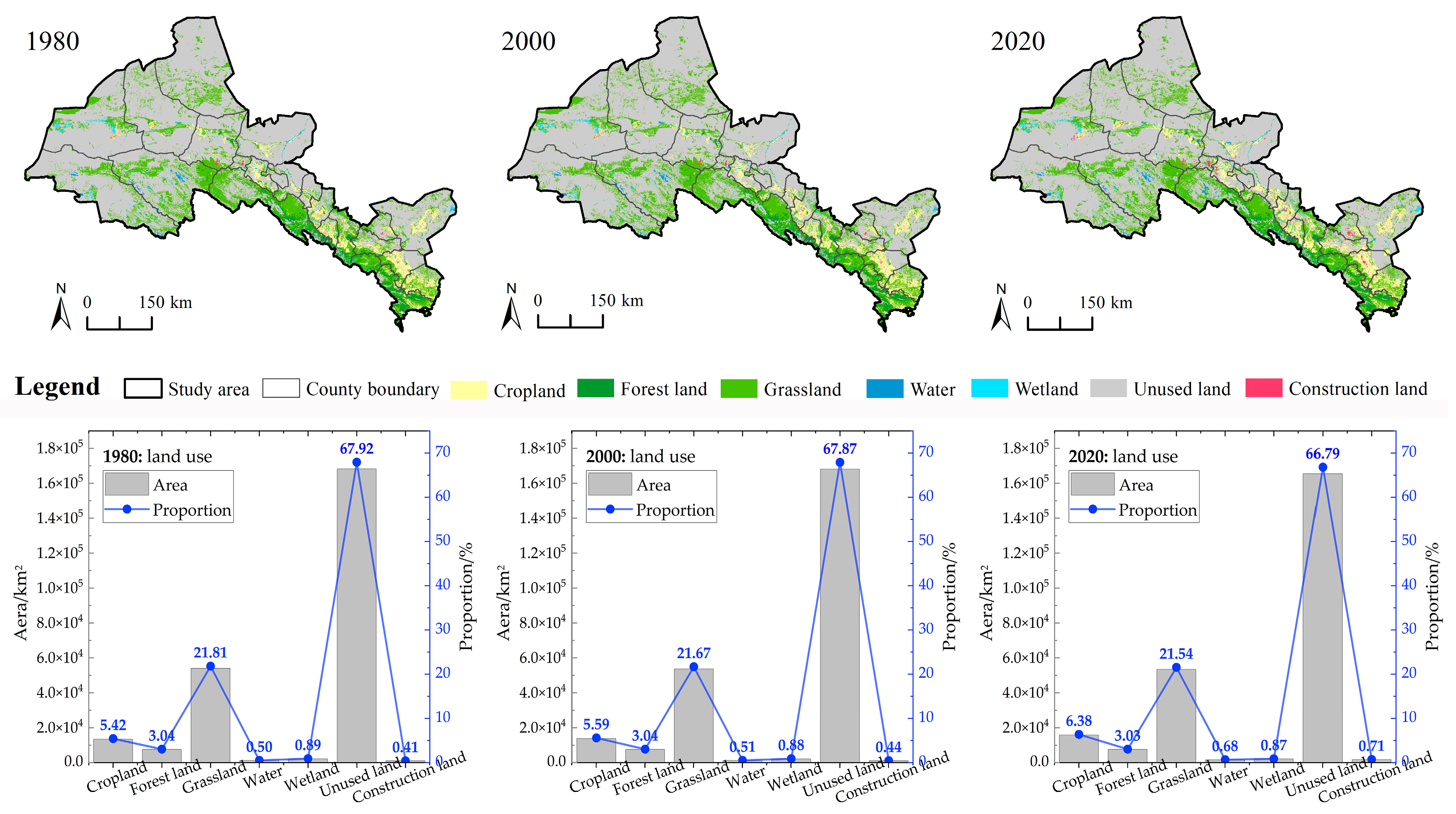
The landscape type of the Hexi Corridor is characterized by a typical Mountain–Oasis–Desert pattern, with the land use types being distributed from southwest to northeast, showing the distribution characteristics of mountains dominated by forestland and grassland, oases dominated by cropland, and desert dominated by unused land (Figure 2). During the study period, the areas of cropland, water, and construction land all showed a growing trend, particularly construction land, which increased from 0.44% to 0.71% from 2000 to 2020. The areas of forestland and grassland showed a small fluctuating decrease, and the area of unused land was continuously reduced, and the shrinkage was larger in 2000–2020 than in 1980–2000. Since 2000, the urbanization process has been accelerated, the range of human production and life has gradually expanded to the periphery, and the unused land at the edge of the oasis has been developed (Figure 3). Although the area of cropland and construction land in the Hexi Corridor has increased significantly, and the area of unused land has shrunk significantly during the study period, the land use structure has not changed substantially. The region is still dominated by unused land, which accounts for about 67% of the total area.
During the study period, the land use transition pattern of the Hexi Corridor showed different characteristics during different study stages. From 1980 to 2000, the land use transfer is mainly characterized by the transfer of grassland to unused land, followed by the transfer of unused land to grassland (Table 2); from 2000 to 2020, the land use transfer is mainly characterized by the transfer of unused land to arable land, followed by the transfer of grassland (Table 3). Overall, land use in the Hexi Corridor shows a transfer pattern dominated by the transfer of unused land to cropland and grassland, with grassland mainly transferred to cropland (Table 4).

3.2. Spatial and Temporal Characteristics of the Value of Ecosystem Services

In terms of temporal changes, the value of ecosystem services as a whole showed an increasing trend from 1980 to 2020 (Table 5). It was found that of the four ecosystem services in the Hexi Corridor, in order of value volume, they were regulating service, supporting service, supply service, and cultural service. During the study period, the value volume of supply service increased the most, with a growth rate of 7.09%, and the value volume of cultural service changed the least. The results of ecosystem service value assessment were graded and presented spatially using the natural breakpoint method (Figure 4). In terms of spatial pattern, the distribution of ecosystem service values in the Hexi Corridor is characterized by geographical differentiation, generally showing a distribution pattern of high in the south and low in the north, with the high-value area mainly distributed in the southern mountains, the higher and medium-value areas mainly distributed in the central oasis, and the low value mainly distributed in the northern desert.

3.3. Changes in the Value of Ecosystem Service Functions in Different Land Types

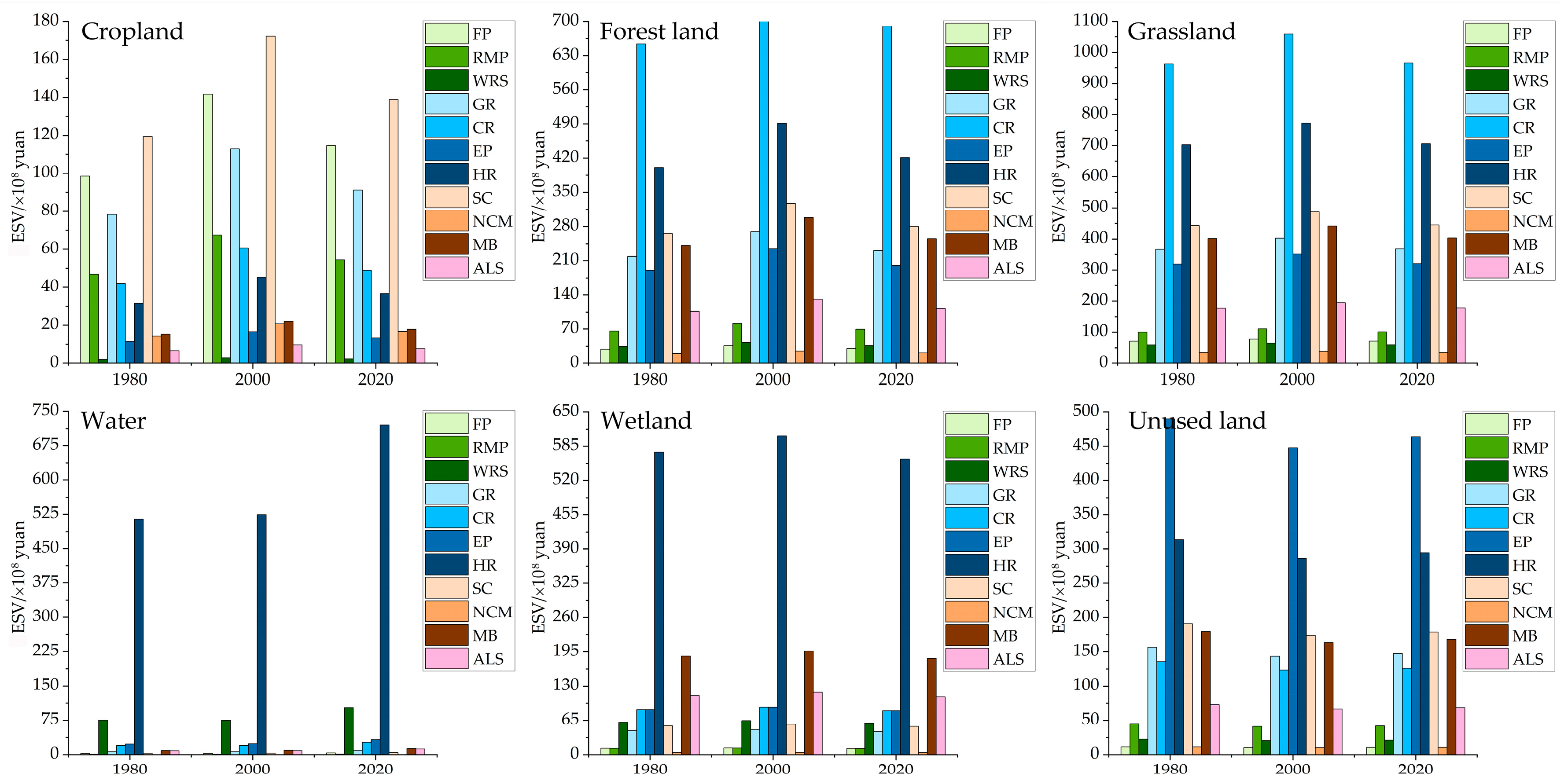
From 1980 to 2020, the functional structure of ecosystem service of different land use types remained relatively stable. Different land use types provided different primary ecosystem services, and the value of ecosystem service would be gained or lost as the area of different land use types changed (Figure 5). In terms of the ecosystem service structure of different land types, cropland was dominated by service supply service, with regulating and supporting service second only to service supply service; forestland, grassland, water, wetland, and unused land were all dominated by regulating service, while forestland, grassland, and unused land have a relatively high proportion of supporting service. In terms of the value of ecosystem service generated by different land types, cropland has the largest soil conservation function, followed by food production function and gas regulation function; forestland and grassland have the largest climate regulation function, followed by hydrological regulation function and soil conservation function; water and wetland have the largest hydrological regulation function, and a comparison of the value of other service functions of the two can be found that the provisioning capacity of wetlands is much larger than the service provisioning capacity of water. A comparison of the value of other service functions between the two revealed that the supply capacity of other service functions of wetlands was much greater than that of water.

3.4. Changes in the Hierarchy of Ecosystem Service Values and Transfer Patterns

During the study period, the conversion patterns between different levels of ecosystem service values were different (Figure 6). From 1980 to 2000, the ecosystem service value grades in the study area were mainly dominated by the transfer of lower to medium and higher, followed by the transfer of lowest to lower, and the grades of ecosystem service value obviously increased. From 2000 to 2020, the area with high levels of ecosystem service value gradually narrowed, and the area with low levels gradually increased. Overall, from 1980 to 2020, the ecosystem service value grades in the study area mainly shifted from lowest to lower, followed by transitions from lower to medium. During the study period, there was an increasing trend in the area of regions with medium and higher ecosystem service value grades.

3.5. Characterization of Spatial Clustering of Ecosystem Service Values

During the study period, the ecosystem service value of the Hexi Corridor showed obvious spatial high–high and low–low clustering characteristics (Figure 7). “High–high” represents clusters of high-value ecosystem services, while “low–low” represents clusters of low-value ecosystem services. The high–high type was mainly distributed in the southern Qilian Mountains area, involving Sunan County, Shandan County, Tianzhu Tibetan Autonomous County, etc., in terms of the spatial distribution of land use. These counties have a wider distribution of forestland and grassland within their boundaries, less impact from human activities, and a relatively adequate supply of ecosystem service, so the value of ecosystem service is higher, and the high–high clustering feature is formed spatially. With the passage of time, the scope of the high–high agglomeration area gradually expands, indicating that the ecological environment in the region has continued to improve during the study period, and the ecological inputs made by the local government and other stakeholders have been rewarded, and ecological degradation and other problems have been effectively managed. The low–low type is mainly located in the western and northern desert areas, including Subei County, Dunhuang City, Akse County, etc. These counties have a large area of ecosystem service, and the value of ecosystem service is high. A large area within these counties is unused land, such as desert, with a single land use type, fragile ecosystems, and weak ecosystem service provisioning capacity, which is a low-value area for ecosystem service value on a regional scale, thus forming the low–low agglomeration feature. At the same time, this agglomeration feature shows a small spatial expansion trend, which, to a certain extent, can illustrate the ecological problems, such as the intensification of desertification in the region. Regions without obvious agglomeration characteristics are mainly distributed in the central and eastern parts of the region, where human activities are frequent, particularly with the increasing area of arable land; the interaction between human activities and the ecological environment is stronger, and this mutual game process strengthens the spatial heterogeneity of the supply and demand of ecosystem service so that the value of ecosystem service does not form the spatial characteristics of high-value agglomeration or low–low agglomeration.

3.6. Ecological Management Zoning

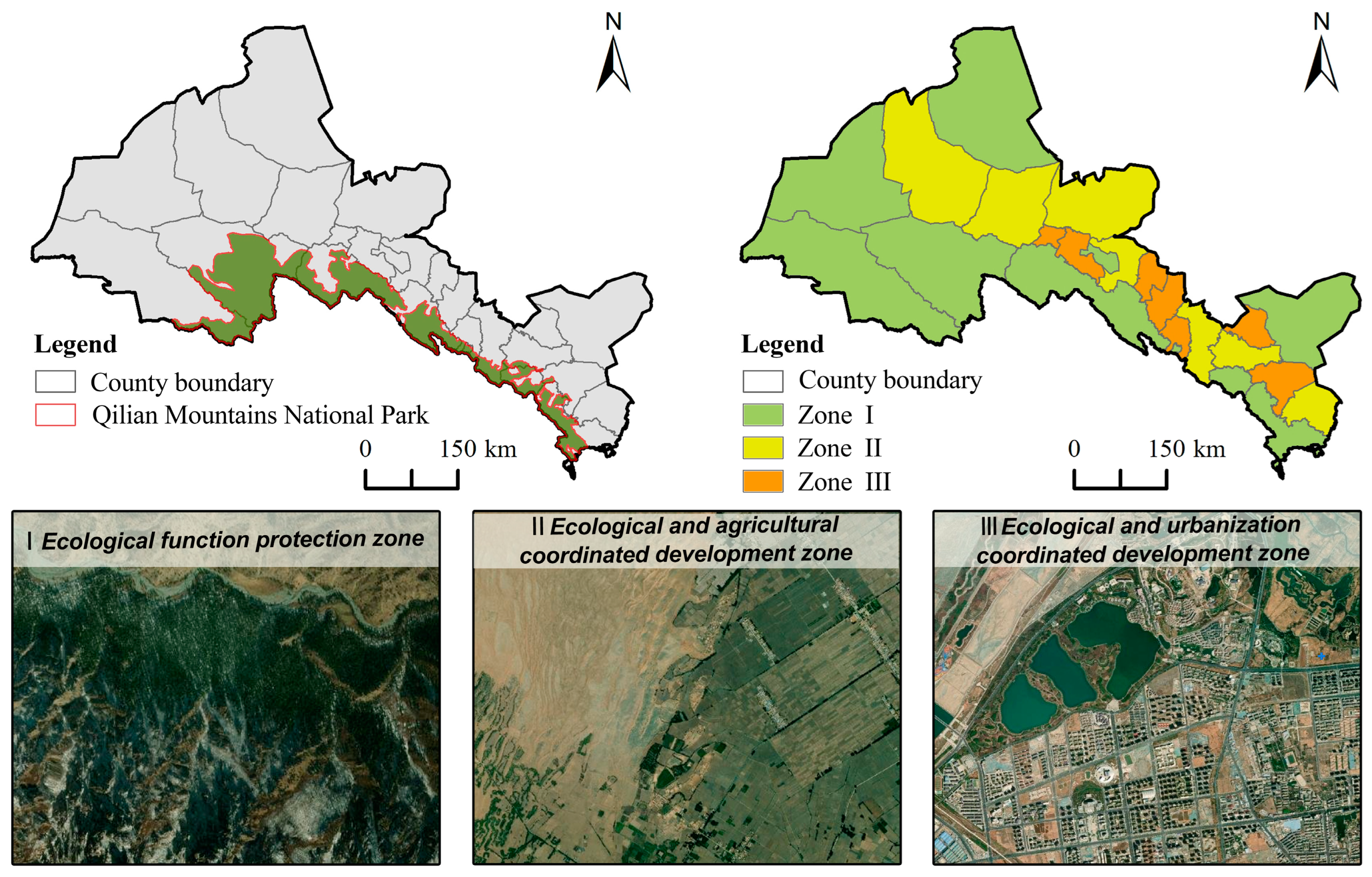
The Hexi Corridor has an important ecological status, and scientific ecological management zoning is an important foundation for promoting ecological environmental protection and the harmonious development of humans and nature. By dividing different ecological management areas, targeted protection measures can be formulated, and the relationship between economic development and environmental protection can be balanced to promote sustainable development. This study combines the spatial agglomeration characteristics of regional land use patterns and the ecosystem service value to propose an ecological zoning plan with counties as the basic unit. The Hexi Corridor is divided into an ecological function protection zone, areas for coordinated development of ecology and agriculture, and areas for coordinated development of ecology and urban areas (Figure 8). The I ecological function protection zone is mainly in areas with high ecosystem service value and high concentration, mainly distributed in the northwestern part of the Hexi Corridor and the northern foothills of the Qilian Mountains in the south, including Sunan County, Tianzhu Tibetan Autonomous Prefecture, Dunhuang City, Akesai County, Subei County, and Minqin County, etc., which is an important support for the construction of a northwestern ecological security barrier in the Hexi Corridor. The ecosystem service values of the II ecological and agriculture coordinated development zone and the III ecological and urbanization coordinated development zone do not have obvious spatial clustering characteristics, and the two are interspersed along the oasis area in the central part of the Hexi Corridor. The II ecology–agriculture coordinated development area includes Guazhou County, Gaotai County, Jinta County, Yongchang County, Yumen City, Shandan County, and Gulang County, which are the main agricultural product production areas in the Hexi Corridor. The III ecology–urbanization coordinated development zone includes Minle County, Jinchuan District, Ganzhou District, Linze County, Suzhou District, Jiayuguan City, and Liangzhou District etc., which is the key area for urbanization construction and development in the Hexi Corridor.
The ecological function protection zone focuses on protecting the ecological functions and services of the ecosystem, with the main goal of preserving the integrity and biodiversity of the ecosystem. The ecological and agriculture coordinated development zone emphasizes the effective integration of ecological environment and agricultural production, promoting mutual support between sustainable agricultural development and environmental protection. The ecological and urbanization coordinated development zone aims to achieve harmonious integration of urbanization processes and the ecological environment, promoting sustainable development of cities and environmental protection. This ecological zoning plan aims to optimize land use patterns, maximize the utilization of ecosystem services, and provide a scientifically reasonable ecological protection and development plan for the Hexi Corridor region’s sustainable development.

4. Discussion

4.1. Mechanisms Affecting the Value of Ecosystem Services in the Hexi Corridor

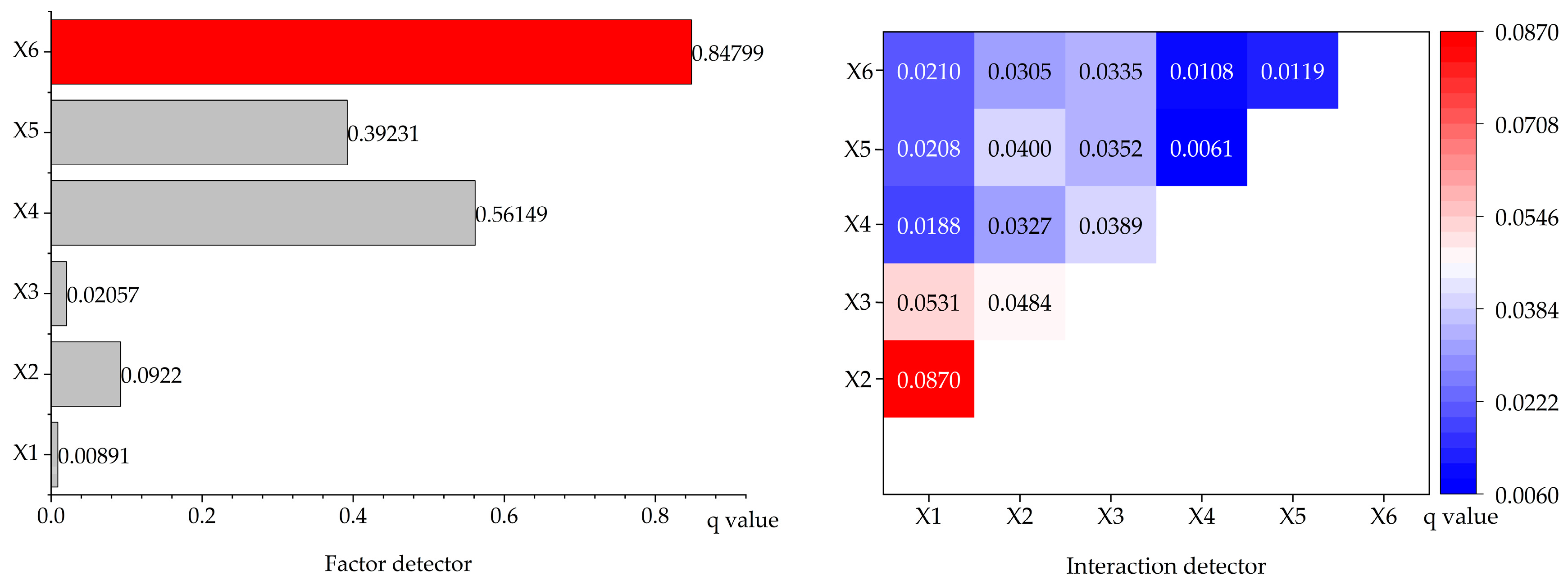
Ecosystem service value is affected by the combined effects of multiple factors [38,39]. Ecosystem service value was extracted from the center point of the grid as the dependent variable, with six indicator factors serving as independent variables: annual average temperature (X1), average annual precipitation (X2), elevation (X3), population density (X4), GDP density (X5), and construction land index (X6) as independent variables, and explored the influence mechanism of ecosystem service value in the Hexi Corridor through the factor contribution rate and two-factor interaction quantitative analysis.
Using the optimal parameters-based geographical detector model, the contribution of six indicator factors to the spatial differentiation of ecosystem service values in the Hexi Corridor was obtained. The q-value of each factor, in descending order, are as follows: construction land index (X6) > population density (X4) > GDP density (X5) > average annual precipitation (X2) > elevation (X3) > average annual temperature (X1) (Figure 9). Overall, the influence of socio-economic factors on the spatial differentiation of ecosystem service value (ESV) in the Hexi Corridor is much larger than that of natural environment factors. The construction land index had the strongest effect on ESV with a q-value of 0.84799, followed by population density and GDP density. Human activities change the surface structure and the stability of the ecosystem, and the more concentrated the population is, the more frequent the human activities, such as urban expansion and economic production, and the more the ESV is disturbed. The average annual precipitation among the natural environmental factors has a greater impact on ESV. The Hexi Corridor is in an arid and semi-arid area with low annual average precipitation, while the area around the Qilian Mountains in the south, with higher elevation terrain, traps a large amount of water vapor, has more annual average precipitation and better vegetation production, so the ecosystem service value shows a significant high and high clustering phenomenon in space.
Based on the results of factor interaction detection, the internal interaction of natural environmental factors had the most significant impact, followed by the interaction of natural environmental factors with socio-economic factors, and the internal interaction of socio-economic factors had the least significant impact. The interaction of mean annual precipitation ∩ average annual temperature had the most significant effect on ESV, followed by mean annual temperature ∩ elevation and mean annual precipitation ∩ elevation. The effects of different factors and two-factor interactions on the ecosystem service value are considerably variable. The Hexi Corridor itself is significantly affected by the natural environment, and the effects of human activities on the ecosystem have a magnifying effect. In order to maintain the stability of the regional ecological security pattern and the sustainable development of ecosystem service provision, attention should be paid to adopting multifaceted regulation means to avoid ecosystem degradation and loss of ecosystem service value caused by overloading of human activities by changing and optimizing land use.

4.2. Ecological Management Strategies

With the Tibetan Plateau at its back in the south and the northern sand belt in the north, the Hexi Corridor has an important position in the national ecological security pattern. The western development, the “One Belt, One Road” initiative, and the rural revitalization strategy have brought great opportunities for the socio-economic development of the Hexi Corridor, but the ecological risks and challenges brought by the economic development have also arisen. In accordance with the principles of scientific management, zoning, and hierarchical precision, this study divided the key functional zones for ecological management into counties as the basic unit, taking into account the current state of land use in the region as well as the spatial and temporal characteristics of the value of ecosystem services (Figure 9). This approach is of immense importance for safeguarding the ecological security of the Hexi Corridor and harmonizing the relationship between the demand for socio-economic development and the supply of ecosystem services.
The I ecological function protection zone is mainly distributed in the southern Qilian Mountains of the Hexi Corridor, including Sunan County, Tianzhu Tibetan Autonomous Prefecture, Dunhuang City, Akse County, Subei County, Minqin County, etc. This region boasts a diverse geomorphology, including primitive forests, grassland, snow-capped mountains, and other rich ecological resources, as well as rich biodiversity. It serves as the primary ecological function area of the Hexi Corridor. Management measures include: (1) Enhancing the water conservation function in the southern part of the protected area by implementing ecological restoration, such as vegetation restoration, soil restoration, and water management, in damaged areas to improve the ecosystem’s service-providing capacity. (2) Adopting an ecological management mode that combines grasslands, irrigation, and arboriculture, in accordance with the region’s arid soil and vegetation characteristics, to strengthen windbreak and sand fixation abilities in the northern part of the area and prevent intensified desertification. (3) Strictly protecting biodiversity in the region, establishing and improving regulations for biodiversity conservation, and safeguarding animal habitats. (4) Establishing an ecological monitoring and assessment system to promptly identify and address issues through regular monitoring and assessment, ensuring effective protection and management of the ecological functional areas.
The II ecological and agriculture coordinated development zone is predominantly situated in a strip along the central part of the Hexi Corridor, including Guazhou County, Gaotai County, Jinta County, Yongchang County, Yumen City, Shandan County, and Gulang County, which are the main agricultural product production zones in the Hexi Corridor. Control measures in the region mainly include: (1) Defining regional development goals and directions, including identifying key areas and key industries for agricultural development, formulating corresponding support policies and measures, and promoting the coordinated development of agriculture and ecology. (2) Promoting the sustainable development of agriculture, accelerating the transformation of agricultural production methods, promoting sustainable agricultural models such as organic agriculture, eco-agriculture, and recycled agriculture in accordance with local conditions, rationally and appropriately exploiting and utilizing arable land, preventing the desertification of arable land, and reducing the negative impact of agriculture on the environment. (3) Rationally planning and managing agricultural resources, such as agricultural land, water resources, and agricultural product markets. This involves optimizing the allocation of agricultural resources through measures such as land remediation, water resource management, and the circulation of agricultural products, as well as promoting the coordination of ecological protection and agricultural development.
The III ecological and urbanization coordinated development zone is mainly located in the oasis area in the central part of the Hexi Corridor, including Minle County, Jinchuan District, Ganzhou District, Linze County, Suzhou District, Jiayuguan City, and Liangzhou District, which is a key area for urbanization construction and development in the Hexi Corridor. The control measures in this region mainly include: (1) Enhancing urban planning and construction management, optimizing urban layout by highlighting characteristics, controlling the scale and speed of urban construction, minimizing the impact on the ecological environment, and protecting the urban ecosystem. (2) Strengthening environmental supervision and law enforcement, strictly controlling environmental pollution and illegal behaviors, and establishing and improving the system of rewards and penalties for ecological and environmental protection in urbanization so as to promote the two-pronged approach to the urbanization and the ecological civilization in the process of construction. (3) Enhance citizens’ awareness of environmental protection and their ability to apply environmental protection technologies through publicity activities and training courses so as to promote the sustainable development of urbanization. (4) Rationally utilize resources, promote the construction of a green and low-carbon city in accordance with local conditions and develop an environmentally friendly economy so as to realize the coordination between urban development and the ecological environment.

4.3. Limitations and Research Prospective

This study explores the spatiotemporal evolution and driving mechanisms of ecosystem service value in arid regions and proposes ecological management zoning schemes, but it still has certain limitations. Firstly, we accounted for the ecosystem service value of the Hexi Corridor using relatively conventional research methods. When exploring driving mechanisms, the selection of an influencing factor was very limited, which may introduce uncertainty into the research results. Additionally, our study aims to provide a typical case for ecosystem management in global arid regions, but a more universally applicable zoning scheme has not yet been formed. The specific influencing factors in the process of ecological management zoning remain to be further investigated.

5. Conclusions

Taking the Hexi Corridor, a typical area of the Mountain–Oasis–Desert composite system, as an example, this study quantitatively assessed the value of ecosystem services, explored its temporal and spatial evolution patterns and characteristics, comprehensively divided the ecological management zones of the Hexi Corridor, and put forward control strategies. The overall conclusions are as follows:
(1)
The Hexi Corridor exhibits pronounced geographic differentiation, and the transition between land-use types is relatively drastic. From the point of view of geographical differentiation, the Hexi Corridor is generally composed of three systems, namely, the southern mountain system, the central oasis system, and the northern desert system. The mountain system is dominated by forestland and grassland, the oasis system is dominated by arable land, and the desert system is dominated by unused land. In terms of land-use type conversion, the conversion of unused land to cropland and grassland is dominant, with cropland having the largest area of conversion.
(2)
The ecological environment of the Hexi Corridor showed a continuous improvement during the study period. The ecosystem service value of the Hexi Corridor shows an increasing trend with significant spatial clustering characteristics; high values are mainly distributed in the southern mountains, high and medium values are mainly distributed in the central oasis, and low values are mainly distributed in the northern desert; the area of the area with medium ecosystem service value and above shows an increasing trend during the study period.
(3)
The natural environment factor at the regional scale is still the decisive factor influencing the value of ecosystem services. From the single-factor detection results, the influence of socio-economic factors on the spatial differentiation of ecosystem service value in the Hexi Corridor is much larger than that of natural environmental factors, in which the construction land index has the strongest influence on ESV with a q-value of 0.84799, followed by population density and GDP density. From the results of two-factor interaction detection, the internal interaction of the natural environment factor was the most significant, followed by the interaction between the natural environment factor and the socio-economic factor, and the internal interaction of the socio-economic factor was the smallest.
(4)
There are significant spatial differences in the ecosystem structure and functions of the Hexi Corridor, and ecological management zoning can effectively promote regional sustainable development. The comprehensive analysis divides the Hexi Corridor into three ecological management zones: I ecological function protection zone, II ecological and agriculture coordinated development zone, and III ecological and urbanization coordinated development zone.

Author Contributions

Conceptualization, L.Y.; methodology, L.Y.; software, L.Y.; data curation, L.Y.; formal analysis, L.Y. and X.Z.; writing—original draft preparation, L.Y., X.Z., J.Y. and Y.L.; writing—review and editing, X.Z., H.D. and X.L.; funding acquisition, L.Y. and X.Z.; validation, L.Y., X.Z., J.Y., Y.L., H.D. and X.L.; Supervision, L.Y., X.Z., J.Y., Y.L., H.D. and X.L. All authors have read and agreed to the published version of the manuscript.

Funding

This research was funded by the Gansu Province Graduate Innovation Star Project (Grant number 2023CXZX-359), the National Natural Science Foundation of China (Grant number 42101276), the Science and Technology Project of Gansu Province (Grant number 22JR5RA851), the Open project funding project of Key Laboratory of Resource Environment and Sustainable Development of Oasis of Gansu Province (Grant number GORS202104), Science and Technology Project of Gansu Province (Grant number 20JR5RA529), and the National Natural Science Foundation of China (Grant number 41661035).

Data Availability Statement

The data presented in this study are available on request from the author.

Conflicts of Interest

The authors declare no conflicts of interest.

References

  1. Costanza, R.; Darge, R.; De Groot, R.; Farber, S.; Grasso, M.; Hannon, B.; Limburg, K.; Naeem, S.; O’Neill, R.V.; Paruelo, J.; et al. The value of the world’s ecosystem services and natural capital. Nature 1997, 6630, 253–260. [Google Scholar] [CrossRef]
  2. Liu, Z.; Wang, S.; Fang, C. Spatiotemporal evolution and influencing mechanism of ecosystem service value in the Guangdong-Hong Kong-Macao Greater Bay Area. J. Geogr. Sci. 2023, 33, 1226–1244. [Google Scholar] [CrossRef]
  3. Fang, Z.; Ding, T.; Chen, J.; Xue, S.; Zhou, Q.; Wang, Y.; Wang, Y.; Huang, Z.; Yang, S. Impacts of land use/land cover changes on ecosystem services in ecologically fragile regions. Sci. Total Environ. 2022, 831, 154967. [Google Scholar] [CrossRef]
  4. Zhang, X.; Yao, L.; Luo, J.; Liang, W. Exploring Changes in Land Use and Landscape Ecological Risk in Key Regions of the Belt and Road Initiative Countries. Land 2022, 11, 940. [Google Scholar] [CrossRef]
  5. Tronvoll, B. The actor: The key determinator in service ecosystems. Systems 2017, 5, 38. [Google Scholar] [CrossRef]
  6. Liu, C.; Liu, G.; Yang, Q.; Luo, T.; He, P.; Franzese, P.P.; Lombardi, G.V. Emergy-based evaluation of world coastal ecosystem services. Water Res. 2021, 204, 117656. [Google Scholar] [CrossRef]
  7. Long, X.; Lin, H.; An, X.; Chen, S.; Qi, S.; Zhang, M. Evaluation and analysis of ecosystem service value based on land use/cover change in Dongting Lake wetland. Ecol. Indic. 2022, 136, 108619. [Google Scholar] [CrossRef]
  8. Li, W.; Wang, L.; Yang, X.; Liang, T.; Zhang, Q.; Liao, X.; White, J.R.; Rinklebe, J. Interactive influences of meteorological and socioeconomic factors on ecosystem service values in a river basin with different geomorphic features. Sci. Total Environ. 2022, 829, 154595. [Google Scholar] [CrossRef]
  9. Babbar, D.; Areendran, G.; Sahana, M.; Sarma, K.; Raj, K.; Sivadas, A. Assessment and prediction of carbon sequestration using Markov chain and InVEST model in Sariska Tiger Reserve, India. J. Clean. Prod. 2021, 278, 123333. [Google Scholar] [CrossRef]
  10. Sherrouse, B.C.; Semmens, D.J.; Ancona, Z.H. Social Values for Ecosystem Services (SolVES): Open-source spatial modeling of cultural services. Environ. Model. Softw. 2022, 148, 105259. [Google Scholar] [CrossRef]
  11. Nguyen, A.K.; Liou, Y.A.; Li, M.H.; Tran, T. Zoning eco-environmental vulnerability for environmental management and protection. Ecol. Indic. 2016, 69, 100–117. [Google Scholar] [CrossRef]
  12. Hu, Y.; Gong, J.; Li, X.; Song, L.; Zhang, Z.; Zhang, S.; Zhang, W.; Dong, J.; Dong, D. Ecological security assessment and ecological management zoning based on ecosystem services in the West Liao River Basin. Ecol. Eng. 2023, 192, 106973. [Google Scholar] [CrossRef]
  13. Boulad, N.; Hamidan, N. The use of a GIS-based multi-criteria evaluation technique for the development of a zoning plan for a seasonally variable Ramsar wetland site in Syria: Sabkhat Al-Jabboul. Wetl. Ecol. Manag. 2018, 26, 253–264. [Google Scholar] [CrossRef]
  14. Chen, K.; Cong, P.; Qu, L.; Liang, S.; Sun, Z. Wetland degradation diagnosis and zoning based on the integrated degradation index method. Ocean Coast. Manag. 2022, 222, 106135. [Google Scholar] [CrossRef]
  15. Bustamante Becerra, J.A.; Bitencourt, M.D. Ecological zoning of an Andean grasslands (puna) at the manu biosphere reserve, Peru. Int. J. Environ. Sustain. Dev. 2007, 6, 357–372. [Google Scholar] [CrossRef]
  16. Xu, W.; Li, X.; Pimm, S.L.; Hull, V.; Zhang, J.; Zhang, L.; Xiao, Y.; Zheng, H.; Ooyang, Z. The effectiveness of the zoning of China’s protected areas. Biol. Conserv. 2016, 204, 231–236. [Google Scholar] [CrossRef]
  17. Li, Y.; Wu, H.; Shi, Z. Farmland productivity and its application in spatial zoning of agricultural production: A case study in Zhejiang province, China. Environ. Earth Sci. 2016, 75, 159. [Google Scholar] [CrossRef]
  18. Chen, Y.; Yao, M.; Zhao, Q.; Chen, Z.; Jiang, P.; Li, M.; Chen, D. Delineation of a basic farmland protection zone based on spatial connectivity and comprehensive quality evaluation: A case study of Changsha City, China. Land Use Policy 2021, 101, 105145. [Google Scholar] [CrossRef]
  19. Chen, F.; Li, L.; Niu, J.; Lin, A.; Chen, S.; Hao, L. Evaluating ecosystem services supply and demand dynamics and ecological zoning management in Wuhan, China. Int. J. Environ. Res. Public Health 2019, 16, 2332. [Google Scholar] [CrossRef]
  20. Zeng, J.; Cui, X.; Chen, W.; Yao, X. Ecological management zoning based on the supply-demand relationship of ecosystem services in China. Appl. Geogr. 2023, 155, 102959. [Google Scholar] [CrossRef]
  21. Liu, Y.; Li, T.; Zhao, W.; Wang, S.; Fu, B. Landscape functional zoning at a county level based on ecosystem services bundle: Methods comparison and management indication. J. Environ. Manag. 2019, 249, 109315. [Google Scholar] [CrossRef] [PubMed]
  22. Wu, Y.; Gu, C.; Zhang, Y. Towards Sustainable Management of Urban Ecological Space: A Zoning Approach Hybridized by Ecosystem Service Value and Ecological Risk Assessment. Land 2022, 11, 1220. [Google Scholar] [CrossRef]
  23. Yao, L.; Zhang, X.; Luo, J.; Li, X. Identification of Ecological Management Zoning on Arid Region from the Perspective of Risk Assessment. Sustainability 2023, 15, 9046. [Google Scholar] [CrossRef]
  24. Brown, M.G.; Quinn, J.E. Zoning does not improve the availability of ecosystem services in urban watersheds. A case study from Upstate South Carolina, USA. Ecosyst. Serv. 2018, 34, 254–265. [Google Scholar] [CrossRef]
  25. Tao, J.; Lu, Y.; Ge, D.; Dong, P.; Gong, X.; Ma, X. The spatial pattern of agricultural ecosystem services from the production-living-ecology perspective: A case study of the Huaihai Economic Zone, China. Land Use Policy 2022, 122, 106355. [Google Scholar] [CrossRef]
  26. Li, X.; Zhang, X.; Yao, L.; Li, Y.; Lei, Y. The spatiotemporal evolution characteristics and influencing factors of socio-economic resilience in the Hexi region. Resour. Environ. Arid. Areas 2023, 37, 38–47. [Google Scholar]
  27. Shi, F.; Song, C.; Zhao, C.; Zhang, J.; Shi, L. Change of service value of mountain oasis desert complex farmland ecosystem in the Hexi Corridor and its influencing factors. China Desert 2013, 33, 1598–1604. [Google Scholar]
  28. Wei, W.; Nan, S.; Xie, B.; Liu, C.; Zhou, J.; Liu, C. The spatial-temporal changes of supply-demand of ecosystem services and ecological compensation: A case study of Hexi Corridor, Northwest China. Ecol. Eng. 2023, 187, 106861. [Google Scholar] [CrossRef]
  29. Yang, L.; Feng, Q.; Adamowski, J.F.; Deo, R.C.; Yin, Z.; Wen, X.; Tang, X.; Wu, M. Causality of climate, food production and conflict over the last two millennia in the Hexi Corridor, China. Sci. Total Environ. 2020, 713, 136587. [Google Scholar] [CrossRef]
  30. Feng, Q.; Yang, L.; Deo, R.C.; AghaKouchak, A.; Adamowski, J.F.; Stone, R.; Yin, Z.; Liu, W.; Si, J.; Wen, X.; et al. Domino effect of climate change over two millennia in ancient China’s Hexi Corridor. Nat. Sustain. 2019, 2, 957–961. [Google Scholar] [CrossRef]
  31. Xu, X.; Liu, J.; Zhang, S.; Li, R.; Yan, C.; Wu, S. China Multi period Land Use Remote Sensing Monitoring Dataset (CNLUCC). Resource and Environmental Science Data Registration and Publishing System. Available online: http://www.resdc.cn/DOI2018.DOI:10.12078/2018070201 (accessed on 5 January 2022).
  32. Xie, G.; Zhang, C.; Zhang, L.; Chen, W.; Li, S. Improvement of ecosystem service valuation method based on unit area value equivalence factor. J. Nat. Resour. 2015, 30, 1243–1254. [Google Scholar]
  33. Zhang, X.; Luo, J.; Shi, P.; Zhou, L. The spatiotemporal evolution of ecosystem service value and terrain gradient differentiation characteristics in Zhangye at the grid scale. J. Appl. Ecol. 2020, 31, 543–553. [Google Scholar]
  34. Mokondoko, P.; Manson, R.H.; Ricketts, T.H.; Geissert, D. Spatial analysis of ecosystem service relationships to improve targeting of payments for hydrological services. PLoS ONE 2018, 13, e0192560. [Google Scholar] [CrossRef] [PubMed]
  35. Wang, J.; Xu, C. Geographic detectors: Principles and prospects. J. Geogr. 2017, 72, 116–134. [Google Scholar]
  36. Song, Y.; Wang, J.; Ge, Y.; Xu, C. An optimal parameters-based geographical detector model enhances geographic characteristics of explanatory variables for spatial heterogeneity analysis: Cases with different types of spatial data. GIScience Remote Sens. 2020, 57, 593–610. [Google Scholar] [CrossRef]
  37. Zhang, M.; Kafy, A.A.; Ren, B.; Zhang, Y.; Tan, S.; Li, J. Application of the optimal parameter geographic detector model in the identification of influencing factors of ecological quality in Guangzhou, China. Land 2022, 11, 1303. [Google Scholar] [CrossRef]
  38. Wang, A.; Liao, X.; Tong, Z.; Du, W.; Zhang, J.; Liu, X.; Liu, M. Spatial-temporal dynamic evaluation of the ecosystem service value from the perspective of “production-living-ecological” spaces: A case study in Dongliao River Basin, China. J. Clean. Prod. 2022, 333, 130218. [Google Scholar] [CrossRef]
  39. He, N.; Zhou, Y.; Wang, L.; Li, Q.; Zuo, Q.; Liu, J. Spatiotemporal differentiation and the coupling analysis of ecosystem service value with land use change in Hubei Province, China. Ecol. Indic. 2022, 145, 109693. [Google Scholar] [CrossRef]
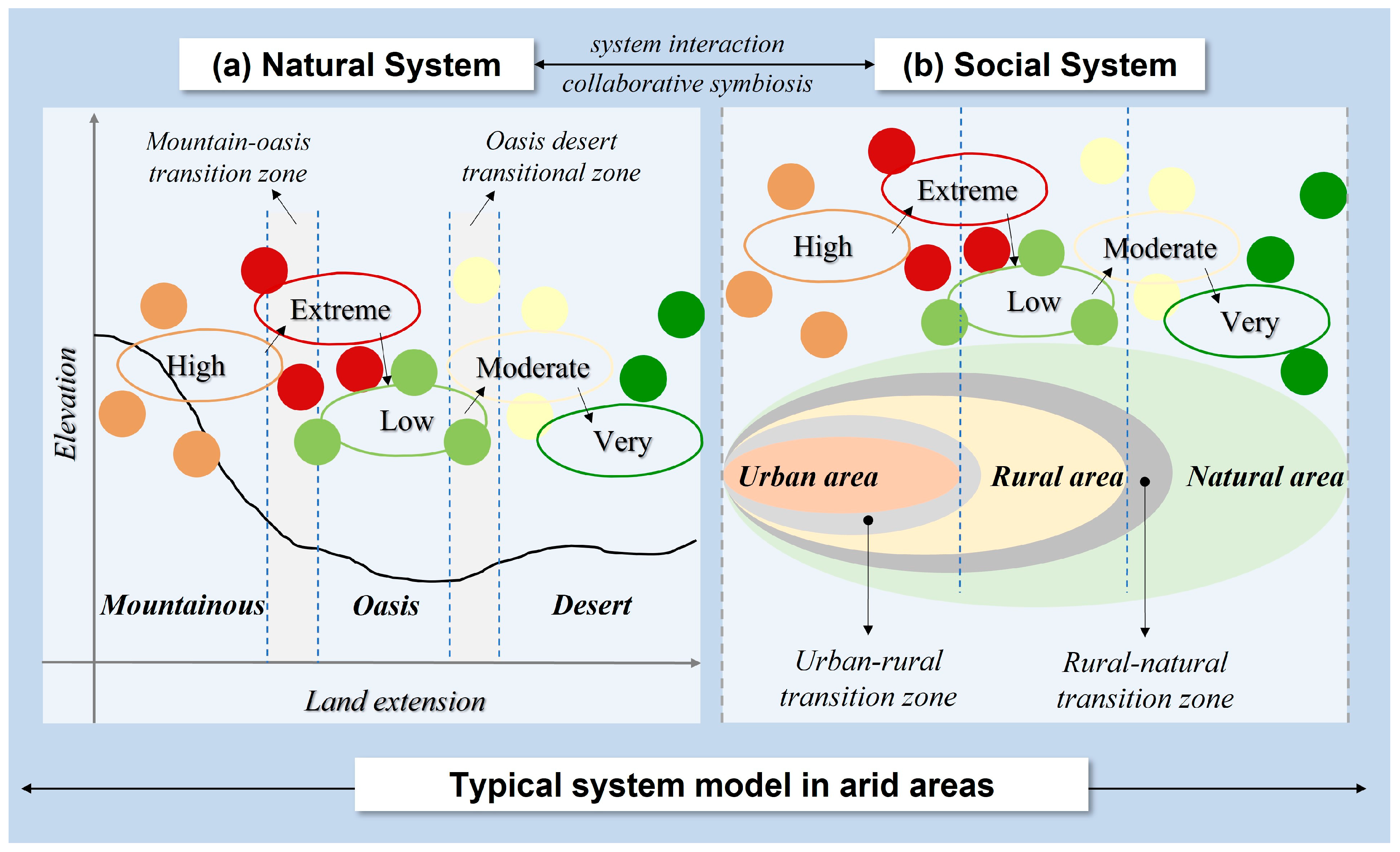
Figure 1. Typical system model and ecological vulnerability diagram in arid areas. (a) represents a natural system; (b) represents a social system.
Systems 12 00166 g001
Figure 2. Overview map of the study area. (a): Desert remote sensing reality; (b): Oasis remote sensing reality; (c): Mountain remote sensing reality.
Systems 12 00166 g002
Figure 3. Spatial and temporal change map of land use.
Systems 12 00166 g003
Figure 4. Spatial pattern of ecosystem service value.
Systems 12 00166 g004
Figure 5. Value of ecosystem service functions for different land use types.
Systems 12 00166 g005
Figure 6. Transfer pattern of ecosystem service level. (a) the area transfer Sangi diagram of ecosystem service levels from 1980 to 2000; (b) the area transfer Sangi diagram of ecosystem service levels from 2000 to 2020; (c) the area transfer Sangi diagram of ecosystem service levels from 1980 to 2020.
Systems 12 00166 g006
Figure 7. Spatial clustering of ecosystem service value (“high–high” represents clusters of high-value ecosystem services, while “low–low” represents clusters of low-value ecosystem services).
Systems 12 00166 g007
Figure 8. Ecological management zoning of Hexi Corridor.
Systems 12 00166 g008
Figure 9. Detection of driving factors for ecosystem services.
Systems 12 00166 g009
Table 1. The equivalent value of ecosystem service per unit area in Hexi Corridor (×104 yuan/hm2).
Ecosystem ClassificationSupply ServiceRegulating ServiceSupport ServiceCultural Service
Primary ClassificationSecondary ClassificationFood ProductionProduction of MaterialWater SupplyGas RegulationClimate RegulationPurify the EnvironmentHydrological RegulationSoil ConservationMaintain Oxygen CirculationBiodiversity ConservationProvide Aesthetic Landscape
CroplandDry field1.03 0.49 0.02 0.82 0.44 0.12 0.33 1.25 0.15 0.16 0.07
Paddy field1.66 0.11 −3.20 1.35 0.69 0.21 3.31 0.01 0.23 0.26 0.11
ForestlandTheropencedrymion0.38 0.86 0.45 2.86 8.56 2.42 4.27 3.48 0.27 3.16 1.39
Shrub0.23 0.52 0.27 1.72 5.15 1.56 4.08 2.09 0.16 1.91 0.84
GrasslandGrassland0.12 0.17 0.10 0.62 1.63 0.54 1.19 0.75 0.06 0.68 0.30
WaterRiver system0.97 0.28 10.09 0.94 2.79 6.75 124.43 1.13 0.09 3.10 2.30
Glacier Snow cover0.00 0.00 2.63 0.22 0.66 0.19 8.68 0.00 0.00 0.01 0.11
WetlandWetland0.62 0.61 3.15 2.31 4.38 4.38 29.49 2.81 0.22 9.58 5.76
Unused landDesert0.01 0.04 0.02 0.13 0.12 0.38 0.26 0.16 0.01 0.15 0.06
Bare land0.00 0.00 0.00 0.02 0.00 0.12 0.04 0.02 0.00 0.02 0.01
Table 2. Land use transfer matrix for the different land use types from 1980 to 2000 (km2).
Land Types2000
CroplandForestlandGrasslandWaterWetlandUnused LandConstruction LandTotal Area of Land Lost
1980Cropland13,034.50 14.90 175.49 7.06 9.87 101.28 86.06 394.66
Forestland19.87 7362.97 118.61 0.82 2.80 32.91 0.69 175.69
Grassland361.88 121.66 52,713.54 7.68 15.69 769.14 9.75 1285.81
Water9.59 0.87 6.39 1203.96 10.02 17.92 0.06 44.86
Wetland47.98 2.04 17.56 20.90 2106.96 16.69 0.20 105.37
Unused land330.57 32.36 631.39 24.32 24.28 167,109.60 12.04 1054.96
Construction land34.05 0.60 2.55 0.03 0.20 2.29 968.87 39.72
Total area of land added803.93 172.43 951.99 60.81 62.86 940.24 108.80 3101.06
Table 3. Land use transfer matrix for the different land use types from 2000 to 2020 (km2).
Land Types2020
CroplandForestlandGrasslandWaterWetlandUnused LandConstruction LandTotal Area of Land Lost
2000Cropland13,386.10 14.04 228.72 10.03 6.11 66.72 126.69 452.30
Forestland93.90 7346.54 28.96 4.88 27.76 23.93 9.43 188.86
Grassland777.60 68.79 52,017.44 38.75 11.15 663.47 88.23 1647.99
Water10.90 0.35 11.17 1154.47 28.75 56.13 2.99 110.29
Wetland42.79 0.60 74.27 55.37 1975.82 12.51 8.46 194.00
Unused land1439.46 80.42 975.27 407.13 105.31 164,535.60 506.18 3513.77
Construction land56.73 1.19 5.12 4.13 0.14 2.12 1008.24 69.43
Total area of land added2421.37 165.39 1323.51 520.29 179.21 824.89 741.99 6176.64
Table 4. Land use transfer matrix for the different land use types from 1980 to 2020 (km2).
Land Types2020
CroplandForestlandGrasslandWaterWetlandUnused LandConstruction LandTotal Area of Land Lost
1980Cropland12,669.20 24.97 358.52 13.88 16.55 139.34 206.70 759.96
Forestland112.62 7187.16 139.63 7.16 30.09 51.69 10.26 351.45
Grassland1091.85 184.51 51,184.11 43.12 26.02 1373.41 97.92 2816.83
Water18.93 1.08 12.61 1118.75 27.62 66.71 3.02 129.97
Wetland89.10 2.60 89.38 62.54 1933.31 26.85 8.60 279.07
Unused land1739.60 110.02 1550.24 425.42 121.22 163,709.80 517.88 4464.38
Construction land86.18 1.53 7.26 3.76 0.25 3.77 905.84 102.75
Total area of land added3138.28 324.71 2157.63 555.89 221.75 1661.76 844.38 8904.39
Table 5. Change of ecosystem service value in Hexi Corridor from 1980 to 2020.
Types of Ecosystem Service Ecosystem Service Value (×108 yuan)Change Rate (%)
1980200020201980–20002000–20201980–2020
Supply Service750.05 865.05 803.21 15.33−7.157.09
Regulating Service6424.47 7025.666683.32 9.36−4.874.03
Support Service2196.05 2452.81 2229.54 11.69−9.101.53
Cultural Service483.59 528.85 487.95 9.36−7.730.90
Total9854.15 10,872.36 10,204.01 10.33−6.153.55
Disclaimer/Publisher’s Note: The statements, opinions and data contained in all publications are solely those of the individual author(s) and contributor(s) and not of MDPI and/or the editor(s). MDPI and/or the editor(s) disclaim responsibility for any injury to people or property resulting from any ideas, methods, instructions or products referred to in the content.