Developing Knowledge-Based Citizen Participation Platform to Support Smart City Decision Making: The Smarticipate Case Study
Abstract
:1. Introduction
- (i)
- Need for domain knowledge which can derive rules to process proposals and generate feedback.
- (ii)
- Enable citizens to interact with the system to create new proposals and obtain automated system generated feedback.
- (iii)
- Fine-granularity of spatial-temporal data, format compatibility and accessibility of OGD to create and process proposals.
- (iv)
- Visualisation of proposals in 3D landscape view.
- (v)
- Ability to run tools from multiple platforms i.e., web, tablets and smartphones.
- (vi)
- Need for an extensible system architecture and design to add and develop new features.
2. Related Work
- CiviQ (http://www.civiq.eu/, last accessed: 27 February 2017)—It provides visual services that visualise the flow of all stakeholder’s opinions, from submissions, consultation and deliberation process;
- COLAB (http://www.colab.re/, last accessed: 27 February 2017)—Is a citizen-to-government engagement platform for issue reporting and public services evaluation as well as participation in decision-making process;
- COMMONPLACE (http://www.commonplace.is/, last accessed: 27 February 2017)—Is an online consultation platform for local participation through dialogues for making more compelling proposals with real-time feedback and analysis presented through live dashboard;
- Sticky World (http://info.stickyworld.com/, last accessed: 27 February 2017)—Allows people to upload and share different types of contents including multimedia contents e.g., videos, images, pdf, audios to exchange ideas visually with others so that they can add comments, while backend systems also generate participative statistics;
- City Swipe (http://www.dtsmcityswipe.com/, last accessed: 27 February 2017)—Provides an intuitive citizen engagement platform to learn about citizens’ preferences and concerns about the city’s urban core through quick questions, which is then used in long-term city plan;
- Land Sight (http://www.landinsight.io/, last accessed: 27 February 2017)—A set of tools that can provide information about a selected site/land, use of the site and can perform preliminary viability assessment indicating what kind of development is likely to receive planning permission;
- Flux Metro (https://metro.flux.io/metro/, last accessed: 27 February 2017)—Allows users to interact with a sample area of Austin, Texas, in 3D environment to visualise a site’s information e.g., context and constraints, heights and shadows. It can be used to get information about building plots and parcels by combining data from different sources which is becoming a challenge to understand development potential and predict profitability outcomes in given scenarios;
- City Life Management (http://www.siemens.com/innovation/en/home/pictures-of-the-future/infrastructure-and-finance/livable-and-sustainable-cities-virtual-urban-planning.html, last accessed: 27 February 2017)—Is an online engagement platform that can help to calculate short- and long-term impact of a planning intervention. For example, a user can place a building object in a 3D model of a site and the platform can generate results such as energy demands, impact on traffic flows, air pollution, etc.;
- UrbanPlanAR (http://urbanplanar.com/, last accessed: 27 February 2017)—Attempts to use mobile augmented reality to capture real-time-in-field visualisation of a proposed development at a site using 3D data to visualise development potential;
- Piazza platform (http://www.piazza.eu/, last accessed: 12 April 2017)—Provides a digital platform to facilitate dialogue between citizens and city administration to test new urban infrastructure or services before entering the planning or implementation phase.
3. The Smarticipate Platform
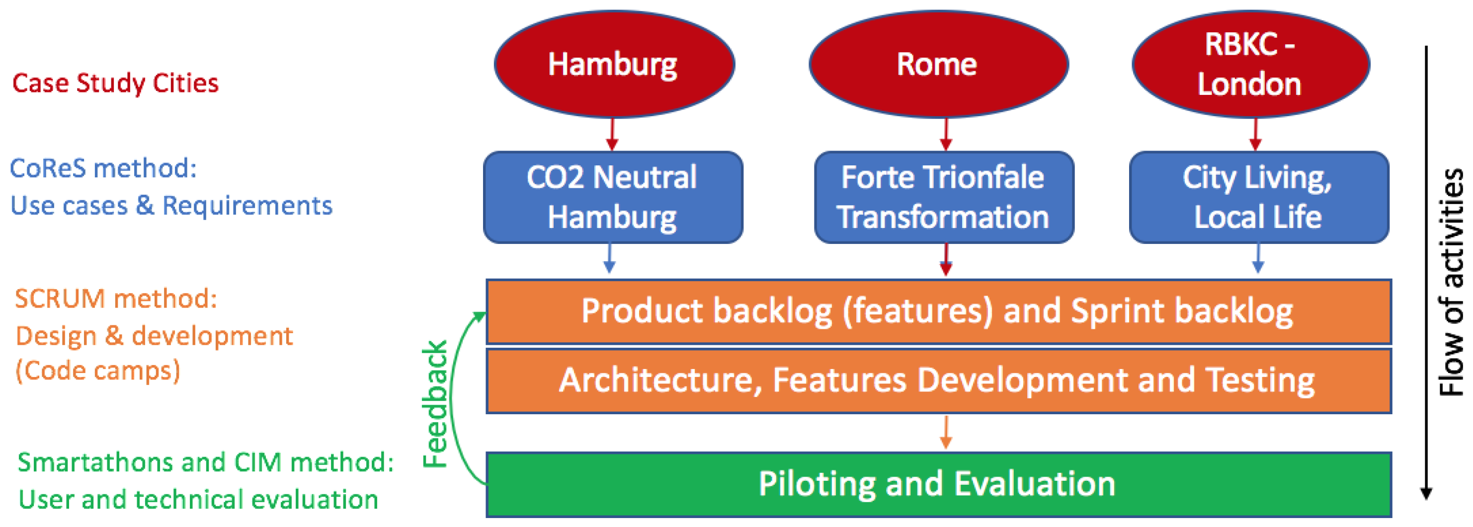
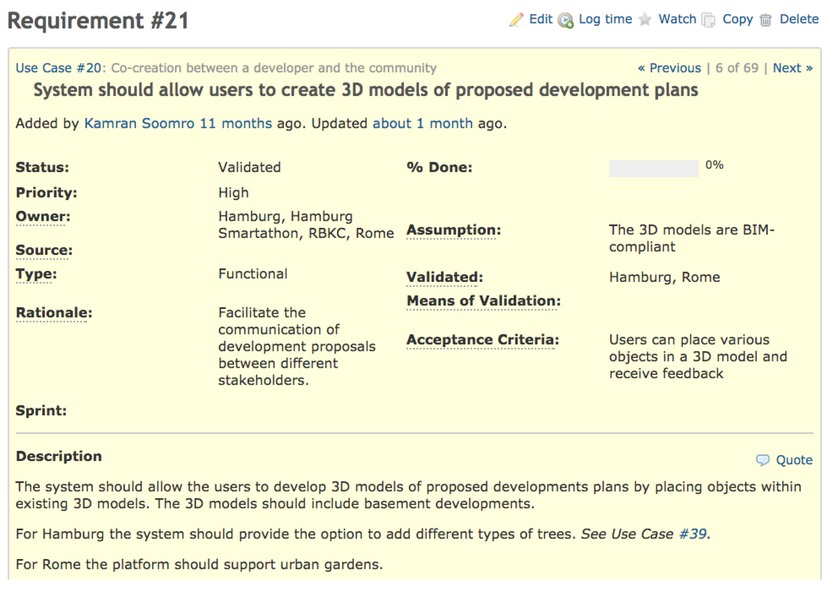
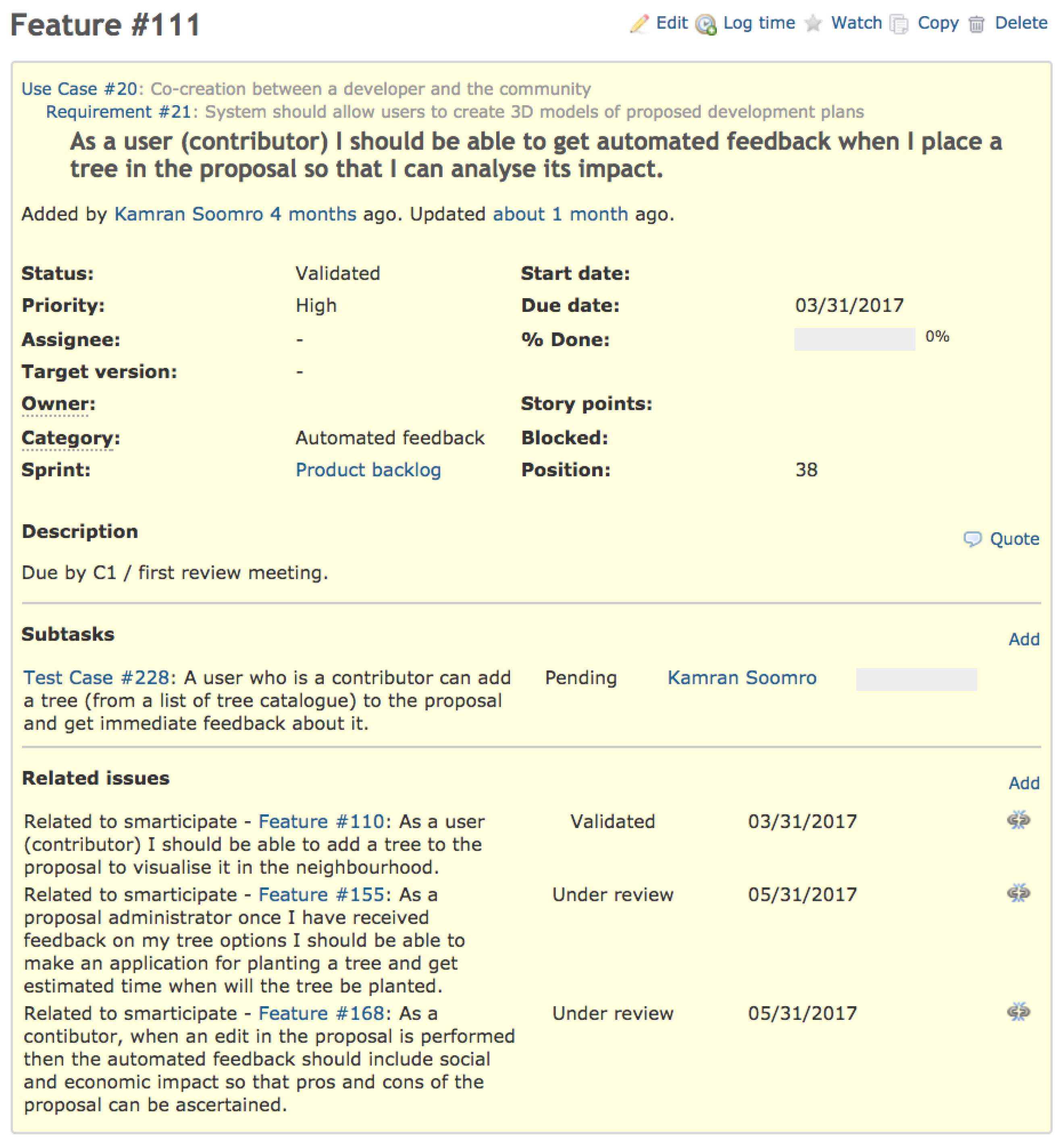
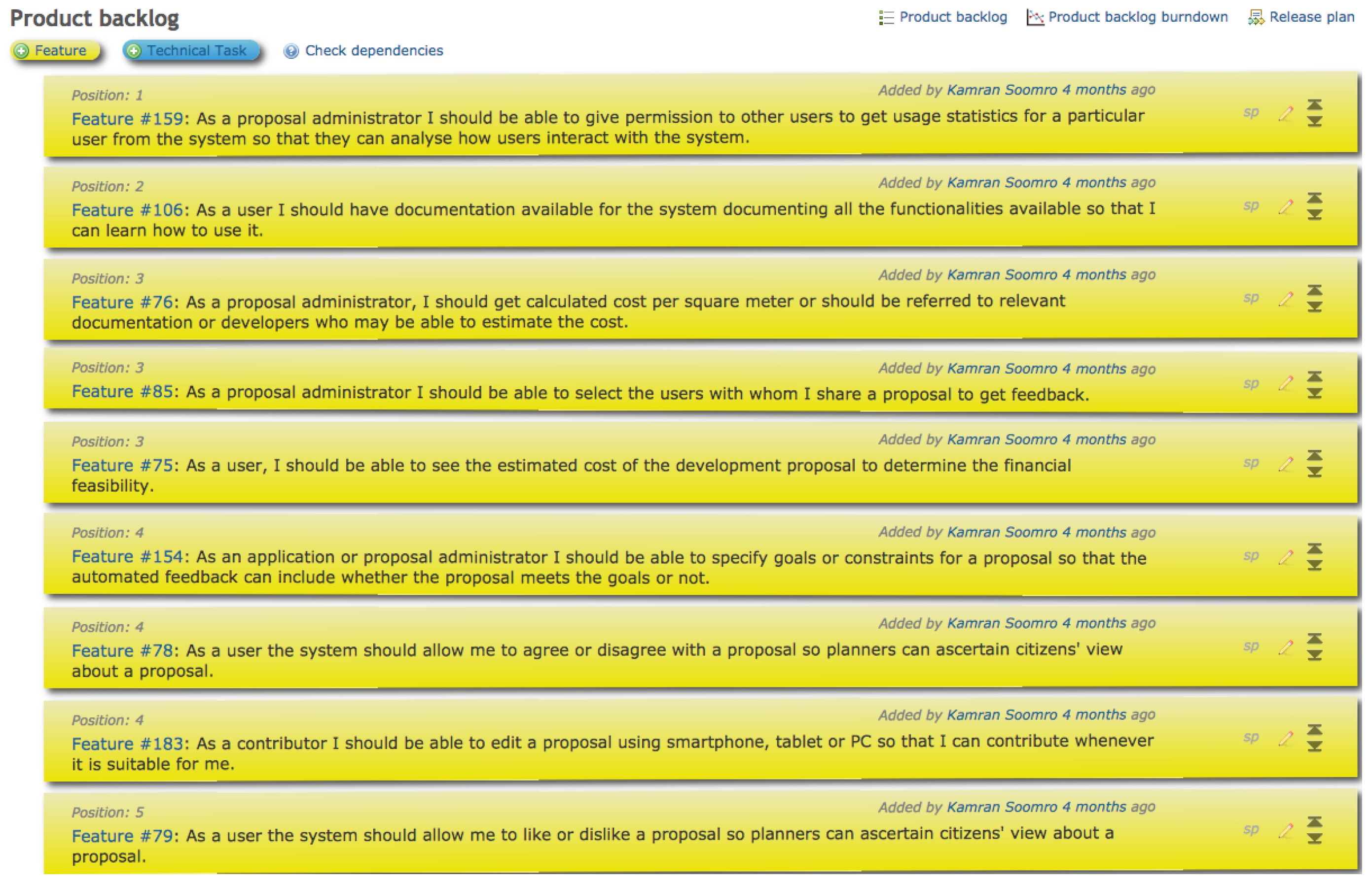
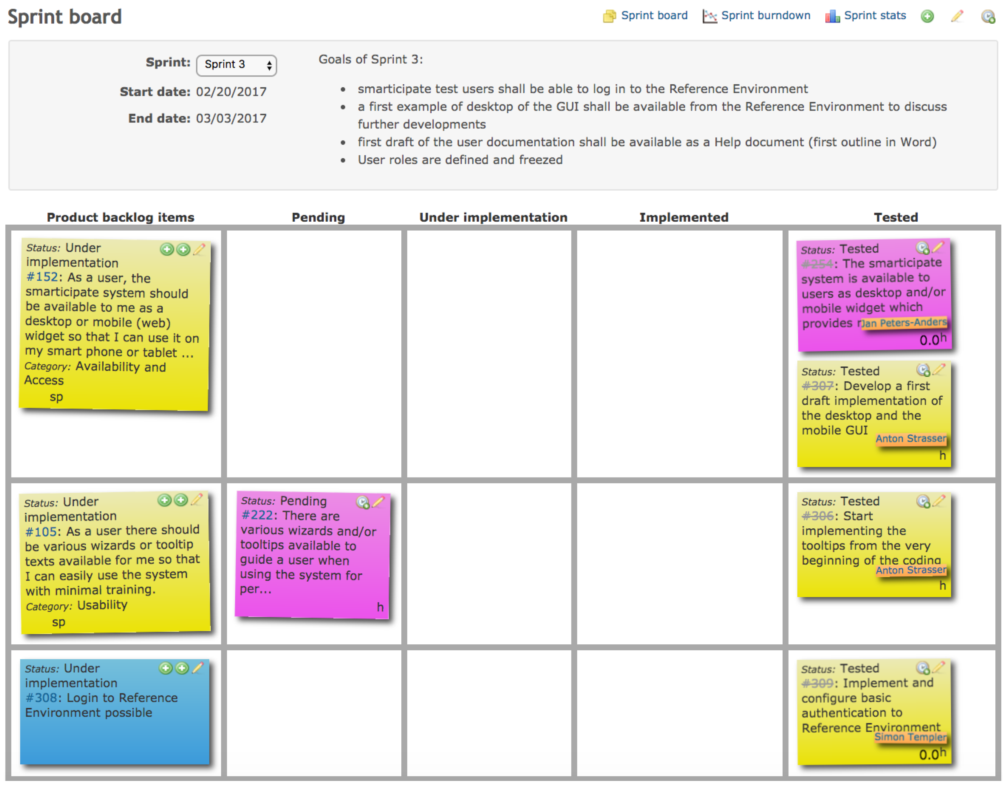
3.1. Smarticipate Methodology
3.2. A Selected Use Case: CO2 Neutral Hamburg—Tree Planting
3.3. Smarticipate System Architecture
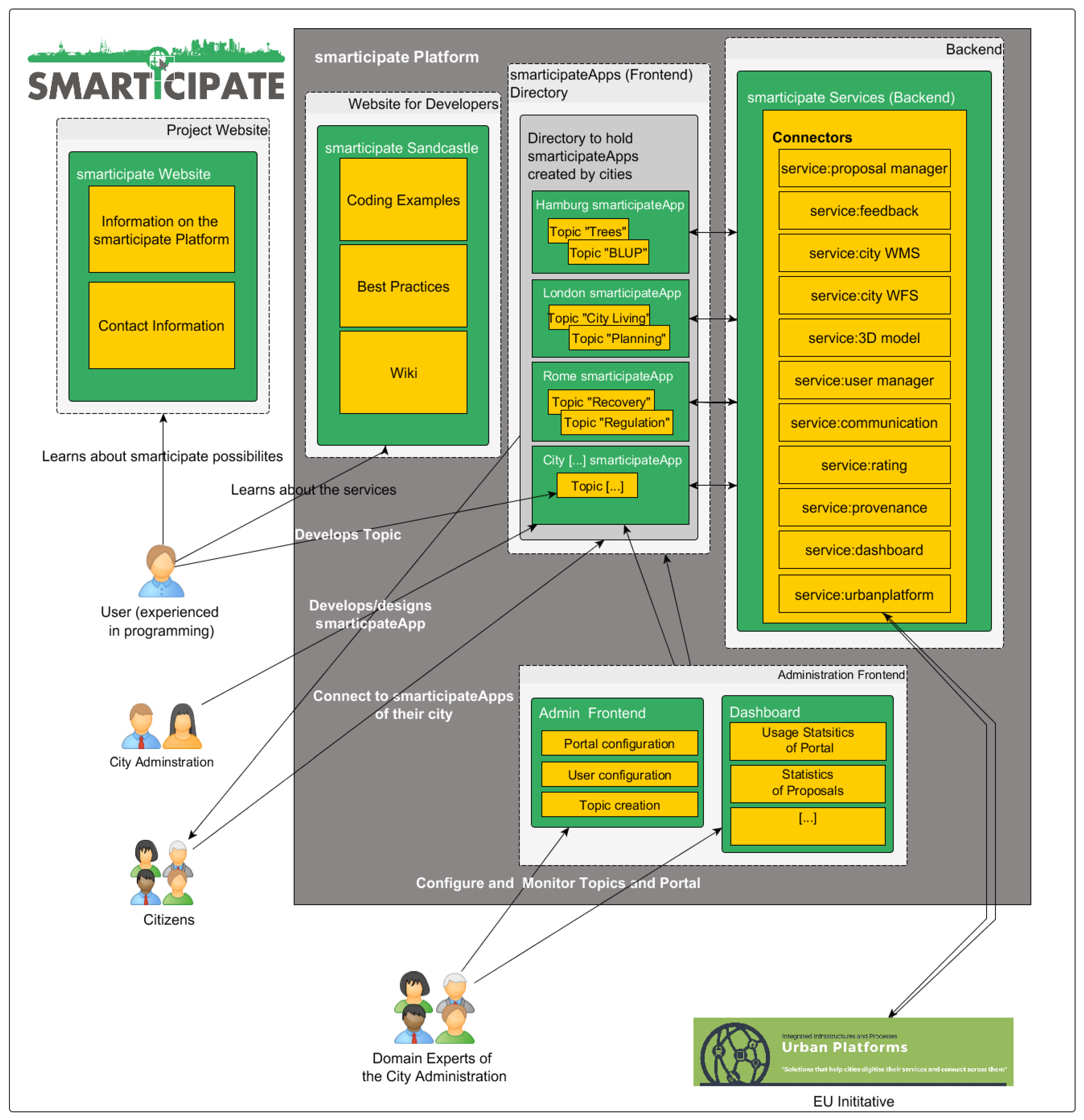
- The Website for developers: It serves as an information hub for users able to code or write software programs. Here, they find coding examples and best practices which enable them to code a Topic for the smarticipateApp of a city e.g., building refurbishments, brown field regeneration, etc.
- SmarticipateApp(s): This is the directory which holds the smarticipateApp of one city (e.g., dedicated server) or more cities (e.g., deployment through centralised server on cloud). The apps themselves contain different Topics.
- Topic(s): Topics hold the content of a participation process being tackled by the city (e.g., the tree planting topic of Hamburg, see below Figure 7). The smarticipateApp comprises of one or more Topics. These topics can be built using OGC or data from other sources which are not available in the public domain.
- Backend-smarticipate services: This is the backend of the platform which connects to the different data sources needed for the participation Topic (e.g., OGD) as well as connections to social media and configuration services for the actual smarticipate platform instance. These services provide functionality for different required features. Currently, the following services are included. However, additional services can be developed and linked due to a micro-services approach (discussed later).
- ○
- Proposal manager service: This service facilitates the different proposals suggested in a specific Topic of the platform. It also manages the different comments and edits made by the different users of the platform.
- ○
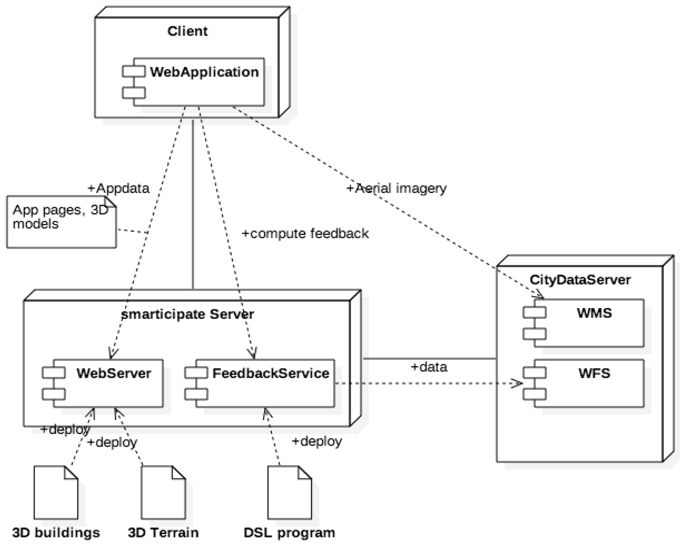
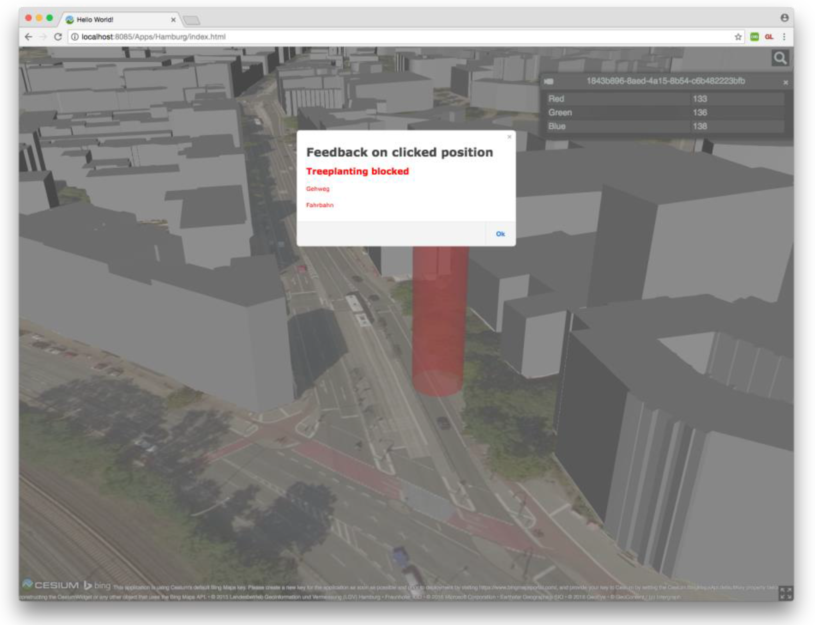
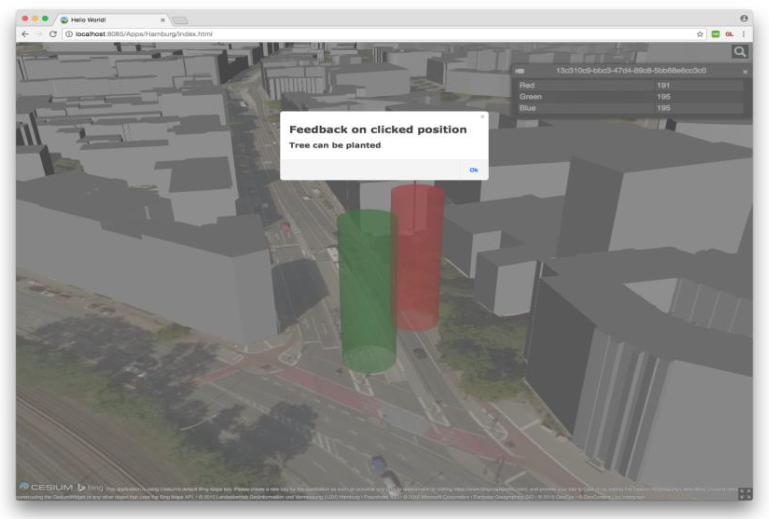
- Feedback service: This is one of the core services of the smarticipate platform. It provides direct feedback for each Topic (from pre-configured data layers and rules). The feedback is requested by clicking on a location or object within the map and the user is then provided with information if a proposal is feasible at this location and if not, why this is the case. In this way, the city planning procedures become more transparent for the citizens.
- ○
- 3D Model service: This service provides 3D data for visualisation purposes (if the city has such data available).
- ○
- WFS (Web Feature Service): This service provides a WFS interface to the platform’s Geoserver. If a certain dataset is not available as Open Data, citizens can create their own service to be used in their Topics.
- ○
- WMS (Web Map Service): Like the WFS service, this service provides a WMS interface to the platform’s Geoserver which enables the creation of own (visual) map layers for the new Topics. This service is useful when required map data is not available via Open Government Data portals.
- ○
- User manager service: This service provides the interface to the user and user rights management system of the platform. This means that different roles and permissions can be set up by the platform administrator.
- ○
- Communication or notification service: This service manages the communication between the users of the platform and sends notifications about new Topics and proposals.
- ○
- Rating service: This service manages the ratings/voting of the different proposals done by the users of the platform.
- ○
- Provenance service: This service is used to keep a track record of all proposals and their edits, enabling a later analysis of the process, which can then lead to a change in the future proceedings of the city planning.
- ○
- Dashboard service: This service provides the interface to the data that is needed to generate various statistics. It provides statistical information such as latest logins of users, number of proposals for each Topic, number of edits, number of votes in favour of a proposal etc.
- ○
- Urban platform service: This service will enable a connection to the Urban Platform initiative’s server. This will ideally be a generic service which will allow similar platforms to be connected in the future.
- Administration Frontend: This is the frontend to configure and monitor the different Topics and their users involved.
- System Dashboard: This is the visual interface which provides all statistics about topics and associated proposals e.g., trend analysis, rating of each proposal, number of users participating in a topic, etc.
- User (experienced in programming): A person with experience in programming who can create Topics using the smarticipate API.
- City Administration: Represents the users within the city administration who configure and monitor the smarticipate platform.
- Citizens: Refers to the users who use the smarticipate platform to give their opinion to the smarticipate Topics and Proposals.
- Domain Experts: These can be urban planners, builders, infrastructure developers, local businesses who are able to share their expert knowledge.
- External EU Initiatives: Other projects and initiatives such as Urban Platforms.
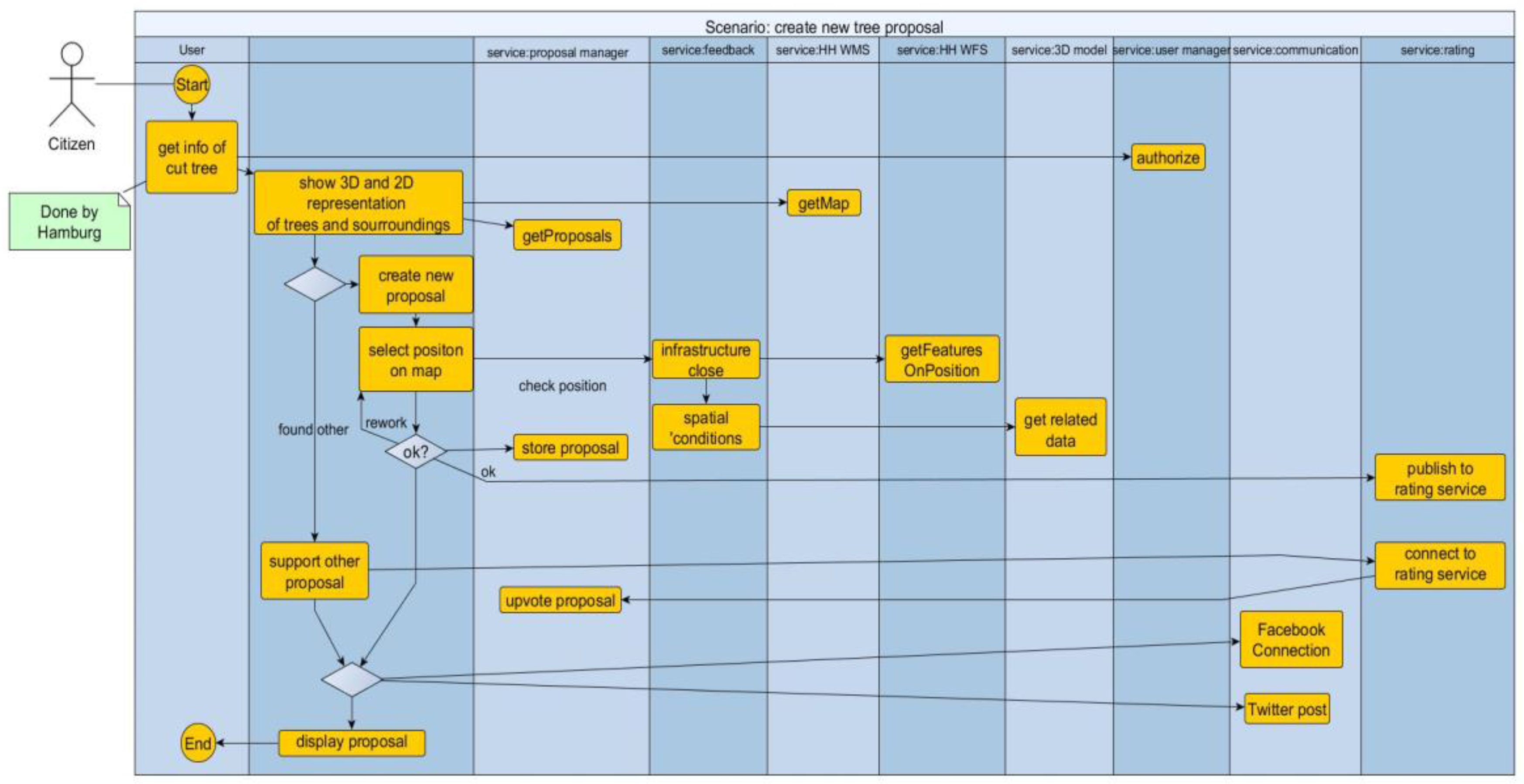
- The second column depicts the “User”.
- The third column (“smarticipateApp”) depicts the workflow of the frontend app to be developed.
- The columns named “service: […]” depict the backend services to be consumed by the smarticipateApp.
3.4. Implementation and Deployment Setup
3.4.1. The SmarticipateApp
3.4.2. Microservices Approach
- Fault tolerance e.g., network errors or outages may occur at any time.
- Latency and limited bandwidth for network access i.e., data access is not cheap.
- Network security must be ensured.
- Changes in network topology can have impacts; networks can be inhomogeneous.
- Administration of a “zoo of machines and services” is expensive.
- Testing requires more effort and additional technology for distributed systems.
3.4.3. Docker as Container Platform
4. Automated Feedback Feature: An Example Service of the Smarticipate Platform
4.1. Conceptual Basis and Feature Design
4.1.1. Modelling Domain Knowledge
- Data availability—usable annotated data or even RDF is not available in the participating cities;
- Annotating data and/or redundant data storage is not feasible for cities;
- Expert users are typically not familiar with complex IT-concepts and would need support in representing domain-specific concepts;
- Definition of dynamic aspects, actions and visualisation is also important besides reasoning.
- Requirements gathering and analysis.
- Definition and analysis of Use Cases and User Stories.
- Domain analysis.
- Definition of a terminology and a Domain Model.
- Mapping of terminology to software artefacts and actions.
- Building of sample DSL scripts and transforming it into a formal grammar.
- Review, test and reiterate if needed.
4.1.2. Conceptual Modelling for Rules—An Example
“Distance to Street Lights: Trees grow and possibly will mask street lights nearby. A minimum distance should be kept from such positions. Positions of street lights need to be given.”
When <Term> then <Action> else <Action>
WHEN X of Tree AND NOT EXISTS Y of Lamp and distance(X, Y) greater than or equals 8m THEN RETURN failure description
Data {
    User input point(wgs84) POSITION
    Map {
        Source.position = project(EPSG:25832, dest.position)
    }
    Datasource wfs TREE http://x.y.z
    Map {
        Source.name = dest.treename
        ...
    }
}
Rules {
    When exists TREE(x) and distance(x, position) less than 8m
    Then result.add("Tree too close to existing tree")
}

Result {
 …
}
- The Data section defines what is the input for the script, how to obtain it (e.g., via OGC WebFeatureService-WFS) and what is expected from the caller (user input e.g., geo-coordinates of a click on a map) as input.
- The Map section is optional and can be used for mapping the data to the terminology used inside the scripts or carry out geospatial re-projection on geo data.
- The Rules section contains the technical rules that contribute to the results of the service.
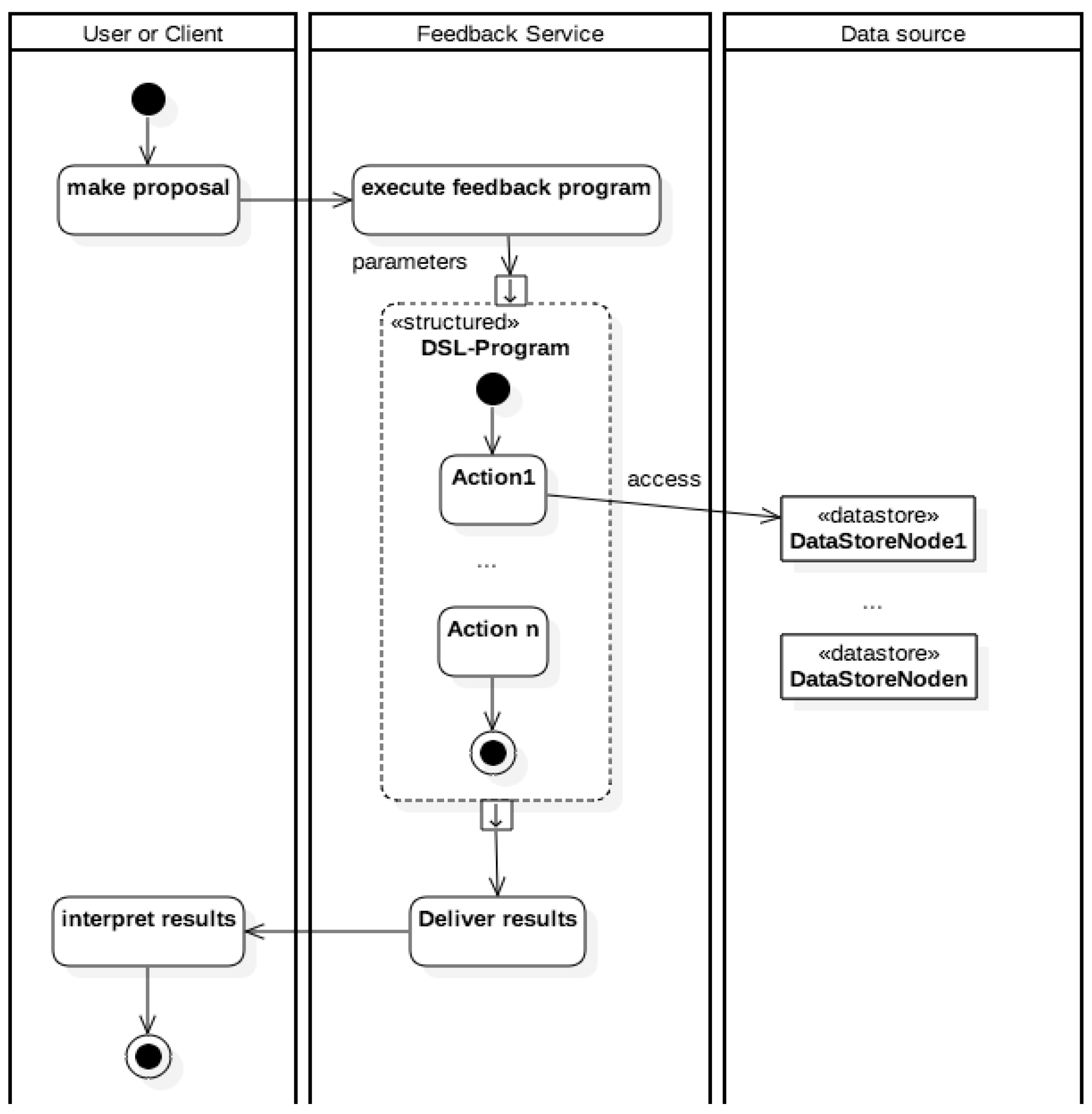
4.1.3. Conceptual Design of the Feedback Service
4.2. Experimental Setup and Proof of Concept of the Feedback Service
4.3. Data for CO2 Neutral Hamburg–Tree Plantation Use Case Context
5. Discussion and Lessons Learned
Based on the above Experience, below We Discuss Some Expected Challenges as Future Research Directions
Validation of Domain Knowledge as Vocabulary and Rules
Tools for DSL Engineering
Availability and Accuracy of Spatio-Temporal Data Elements and Deriving Tacit Knowledge
Visualisation of 3D Models on Different Platforms and Screen Sizes
High Performance Computing for Immediate Knowledge Generation and Feedback
Granularity of Data and Rules
6. Conclusions and Future Work
Acknowledgments
Author Contributions
Conflicts of Interest
References
- Arnstein, S. A ladder of citizen participation. J. Am. Inst. Plan. 1969, 35, 216–224. [Google Scholar] [CrossRef]
- Khan, Z.; Ludlow, D.; Loibl, W.; Soomro, K. ICT enabled participatory urban planning and policy development: The UrbanAPI project. Trans. Gov. People Process Policy 2014, 8, 205–229. [Google Scholar] [CrossRef]
- Dambruch, J.; Krämer, M. Leveraging public participation in urban planning with 3D web technology. In Proceedings of the 19th International ACM Conference on 3D Web Technologies, Vancouver, BC, Canada, 8–10 August 2014; ACM: New York, NY, USA, 2014; pp. 117–124. [Google Scholar]
- Semanjski, I.; Bellens, R.; Gautama, S.; Witlox, F. Integrating Big Data into a Sustainable Mobility Policy 2.0 Planning Support System. Sustainability 2016, 8, 1142. [Google Scholar] [CrossRef]
- Open Government Data. Available online: https://opengovernmentdata.org/ (accessed on 23 February 2017).
- Khan, Z.; Liaquat Kiani, S.; Soomro, K. A framework for cloud-based context-aware information services for citizens in smart cities. J. Cloud Comput. Adv. Syst. Appl. 2014, 3, 14. [Google Scholar] [CrossRef]
- Smarticipate Project. Smart Open Data Services and Impact Assessment for Open Governance; European Commission H2020 Programme. Available online: https://www.smarticipate.eu/ (accessed on 24 February 2017).
- Soomro, K.; Khan, Z.; Ludlow, D. Participatory governance in smart cities: The urbanAPI case study. Int. J. Serv. Technol. Manag. 2017, (in press). [Google Scholar]
- Berntzen, L.; Johannessen, M.R. The Role of Citizen Participation in Municipal Smart City Projects: Lessons Learned from Norway. In Smarter as the New Urban Agenda—A Comprehensive View of the 21st Century City; Public Administration and Information Technology; Springer: Berlin, Germany, 2016; Volume 11, pp. 299–314. [Google Scholar]
- European Commission. A Vision for Public Services; DG-CNECT: Brussels, Belgium, 2013. [Google Scholar]
- Misuraca, G.; Broster, D.; Centeno, C.; Punie, Y.; Lampathaki, F.; Charalabidis, Y.; Askounis, D.; Osimo, D.; Szkuta, K.; Bicking, M. Envisioning Digital Europe 2030: Scenarios for ICT in Future Provenance and Policy Modelling; Misuraca, G., Lusoli, W., Eds.; European Commission: Brussels, Belgium, 2010. [Google Scholar]
- Insight Project. Policy Modelling and Governance Tools for Sustainable Urban Development—State of the Art and Future Challenges. Available online: http://www.nommon-files.es/working_papers/INSIGHT_PositionPaper_Oct2013.pdf (accessed on 8 February 2017).
- Bunt, L.; Harris, M. Mass Localism: A Way to Help Small Communities Solve Big Social Challenges: Discussion Paper. Available online: http://www.nesta.org.uk/sites/default/files/mass_localism.pdf (accessed on 8 February 2017).
- European Commission. Powering European Public Sector Innovation: Towards a New Architecture: Report of the Expert Group on Public Sector Innovation; European Commission: Brussels, Belgium, 2013. [Google Scholar]
- Berman, T. Public participation as an instrument for incorporating local knowledge into planning processes. In Proceedings of the State of Australian Cities Conference, Queensland, Australia, 9–11 December 2015. [Google Scholar]
- Beebeejaun, Y. The Participatory City; Jovis Verlag GmbH: Berlin, Germany, 2016. [Google Scholar]
- Ruppert, T.; Dambruch, J.; Krämer, M.; Kohlhammer, J.; Balke, T.; Gavanelli, M.; Bragaglia, S.; Chesani, F.; Milano, M. Visual Decision Support for Policy Making: Advancing Policy Analysis with Visualization. In Public Administration and Information Technology; Janssen, M., Ed.; International Publishers Association: Geneva, Switzerland, 2015. [Google Scholar]
- Kramer, M.; Khan, Z.; Ludlow, D. Domain-specific languages for agile urban policy modelling. In Proceedings of the 27th European Conference on Modelling and Simulation (ECMS), Alesund, Norway, 27–30 May 2013; pp. 673–680. [Google Scholar]
- Krämer, M. Controlling the processing of smart city data in the cloud with domain-specific languages. In Proceedings of the IEEE/ACM 7th International Conference on Utility and Cloud Computing, Washington, DC, USA, 8–11 December 2014; pp. 824–829. [Google Scholar]
- Future of Planning. Future of Planning—State of the Art Innovations in Digital Planning; Future City Catapult: London, UK, November 2016. Available online: http://futurecities.catapult.org.uk/2016/12/01/future-planning-state-art-innovations-digital-planning/ (accessed on 25 January 2017).
- Cohen, B.; Almirall, E.; Chesbrough, H. The City as a Lab: Open Innovation meets the Collaborative Economy. Calif. Manag. Rev. 2016, 59, 5–13. [Google Scholar] [CrossRef]
- Khan, Z.; Ludlow, D.; Loibl, W. Applying the CoReS requirements development method for building IT tools for urban management systems: The UrbanAPI project. Theor. Empir. Res. Urban Manag. 2013, 8, 25–59. [Google Scholar]
- Redmine. Redmine—Project Management System. Available online: http://www.redmine.org/ (accessed on 8 February 2017).
- Schwaber, K. SCRUM Development Process. In Proceedings of the Workshop on Business Object Design and Implementation at the 10th Annual conference on Object-Oriented Programming Systems, Languages and Applications (OOPSLA’95), Austin, TX, USA, 15–19 October 1995. [Google Scholar]
- Khan, Z.; Ludlow, D.; Rix, J. Applying the criteria indicators and metrics evaluation method on ICT research: The HUMBOLDT project. Res. Eval. J. 2012, 22, 30–40. [Google Scholar] [CrossRef]
- Khan, Z.; Ludlow, D.; Caceres, S. Evaluating a collaborative IT based research and development project. Eval. Progr. Plan. 2013, 40, 27–41. [Google Scholar] [CrossRef] [PubMed]
- Namiot, D.; Sneps-Sneppe, M. On Micro-services Architecture. Int. J. Open Inf. Technol. 2014, 2, 24–27. [Google Scholar]
- Malewski, C.; Dambruch, J.; Krämer, M. Towards Interactive Geodata Analysis through a Combination of Domain-Specific Languages and 3D Geo Applications in a Web Portal Environment. In Proceedings of the REAL CORP Conference, Ghent, Belgium, 5–7 May 2015; pp. 609–616. [Google Scholar]
- Nicola, A.D.; Missikoff, M.; Navigli, R. A software engineering approach to ontology building. Inf. Syst. 2009, 34, 258–275. [Google Scholar] [CrossRef]
- Linked Open Data. Linked Open Data: The Essentials—A Quick Start Guide for Decision Makers. Available online: http://www.semantic-web.at/LOD-TheEssentials.pdf (accessed on 28 February 2017).
| Possible Nouns (Concepts) | |||
|---|---|---|---|
| Proposal | Cost | Goal | Power Lines |
| Infrastructure | Water | Gas | Communication |
| Private Land | Land use | Planned Actions | Tree |
| Species | Neighbourhood | Building | Street Lighting |
| Traffic Signs | Flooding area | Condition of soil | Shadow and Light |
| Sidewalk | Street Access | Bus Lane | Position |
| Possible Actions | |||
|---|---|---|---|
| Agree/Disagree | Calculate costs | Link | Exclude/Include |
| Measure distance | Determine species | Define species | Growth simulation |
| Flooding simulation | Intersection | Shadow masking | |
© 2017 by the authors. Licensee MDPI, Basel, Switzerland. This article is an open access article distributed under the terms and conditions of the Creative Commons Attribution (CC BY) license (http://creativecommons.org/licenses/by/4.0/).
Share and Cite
Khan, Z.; Dambruch, J.; Peters-Anders, J.; Sackl, A.; Strasser, A.; Fröhlich, P.; Templer, S.; Soomro, K. Developing Knowledge-Based Citizen Participation Platform to Support Smart City Decision Making: The Smarticipate Case Study. Information 2017, 8, 47. https://doi.org/10.3390/info8020047
Khan Z, Dambruch J, Peters-Anders J, Sackl A, Strasser A, Fröhlich P, Templer S, Soomro K. Developing Knowledge-Based Citizen Participation Platform to Support Smart City Decision Making: The Smarticipate Case Study. Information. 2017; 8(2):47. https://doi.org/10.3390/info8020047
Chicago/Turabian StyleKhan, Zaheer, Jens Dambruch, Jan Peters-Anders, Andreas Sackl, Anton Strasser, Peter Fröhlich, Simon Templer, and Kamran Soomro. 2017. "Developing Knowledge-Based Citizen Participation Platform to Support Smart City Decision Making: The Smarticipate Case Study" Information 8, no. 2: 47. https://doi.org/10.3390/info8020047
APA StyleKhan, Z., Dambruch, J., Peters-Anders, J., Sackl, A., Strasser, A., Fröhlich, P., Templer, S., & Soomro, K. (2017). Developing Knowledge-Based Citizen Participation Platform to Support Smart City Decision Making: The Smarticipate Case Study. Information, 8(2), 47. https://doi.org/10.3390/info8020047


