
Geospatially Constrained Workflow Modeling and Implementation


Abstract
:
1. Introduction
2. Geospatially Constrained Net Model
2.1. Levels of Geospatial Information Impact on Workflow
- (1)
- First level—Geospatial information only describes the related information about workflow activities in text form, map visualization or other forms, and is always regarded as the attribute information of workflow activities, participant or organization, such as the location of activities implementation, the location of the person or organization.
- (2)
- Second level—Geospatial information influences the workflow activities in a decisive role, including the sites of participant or execution and the workflow trend. However, this geospatial information is previously defined in workflow design, and the workflow instances are implemented in accordance with the design.
- (3)
- Third level—Geospatial information influences the workflow activities in a decisive role too, but these influences is relative to geographic context of workflow activities. The geospatial information asks workflow for positive responses, adjusting the workflow participants, execution locations or process trends in order to achieve the goals of workflow.
2.2. Subjects of Geospatial Constraints
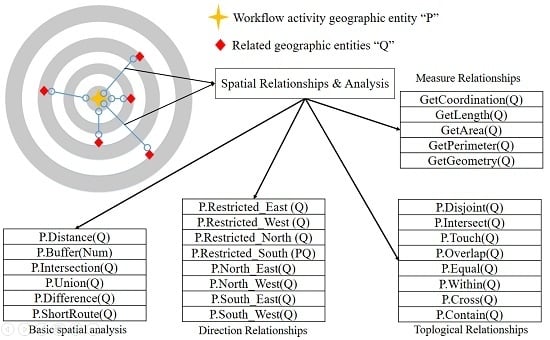
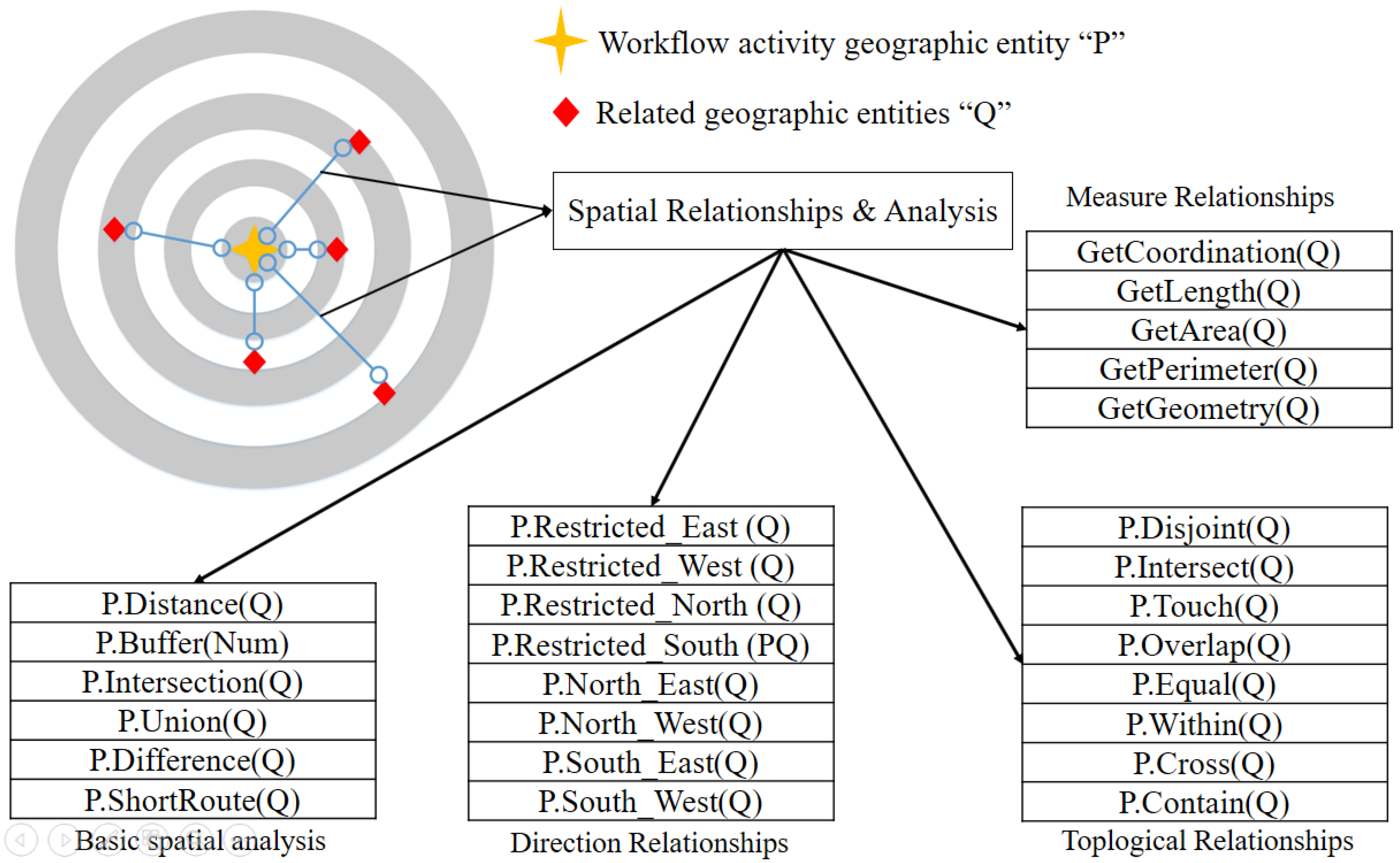
2.3. Geospatial Information Methods Set
2.4. Geospatial Constraints Rules
2.5. Geospatial Constraints States
2.6. Geospatial Constraints Unit
2.7. Geospatial Constraints Net Model
- (1)
- (2)
- (3)
- (4)
- (5)
- (1)
- have the same definitions with the pre-sets, post-set of directed nets.
- (2)
- is the reading set of t, and the set includes inputted geographic entities variables. is the writing set of t, and the set includes the output variables. and must satisfy:
- (3)
- tp(x) represents the geographic entities types of the variable x. When tp(x) is used as a set, it is in a range of x.
- (4)
- Type=tp(x) is the type set of all geographic entity variables.
- (5)
- is called E_ marking of GCNet, if tp .
- (6)
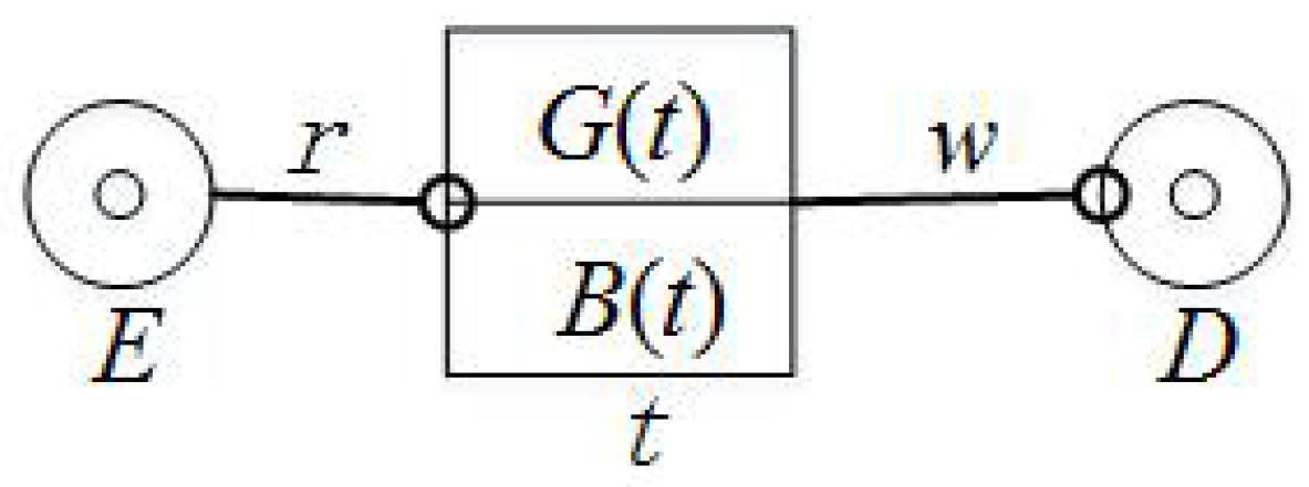
- B is the body function of GCNet, if is a geospatial constraints methods set expressed with semantics. B reads geographic entities variables from , writes the results into after spatial operations with geospatial constraints methods set, and notices the results to G function finally.
- (7)
- G is called a guard function of GCNet, if is a Boolean expression, i.e., whether the results from B satisfy the requirement of geospatial constraints.
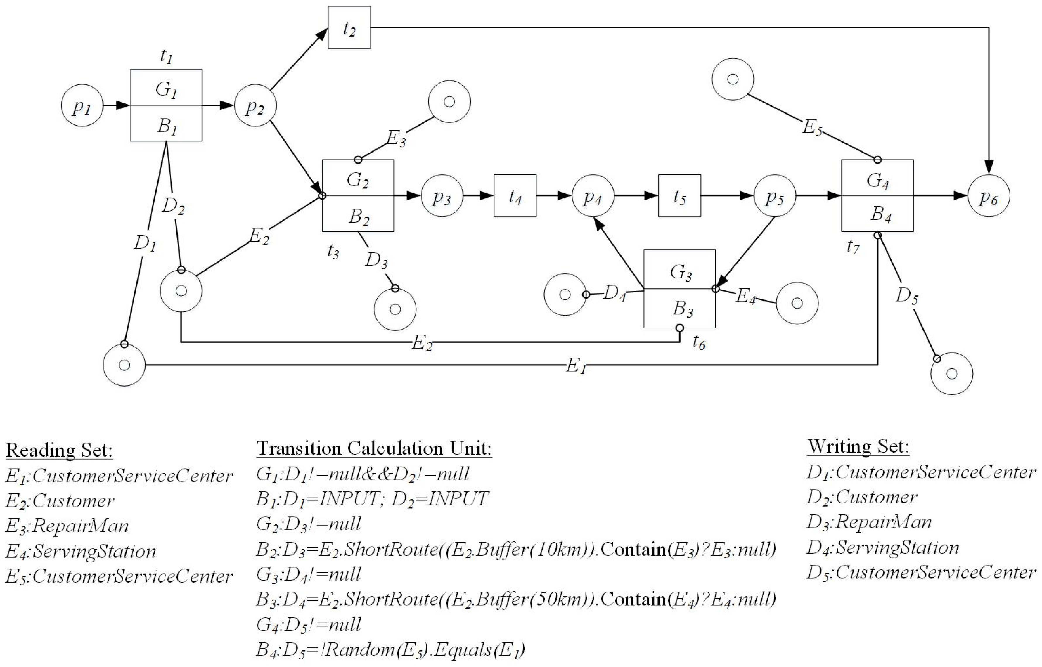
3. Geospatially Constrained Workflow Model
3.1. Definitions of Geospatially Constrained Workflow Model
- (1)
- are the same definitions in WF-net, i.e., WF-net=.
- (2)
- and B are the same definitions in GCNet, and , or .
- (3)
- is called transition marking of GCWF-net and is a state of transition. .
- (4)
- is the marking of P place in GCWF-net and is called P_ marking.
- (5)
- is the marking of E variable place of GCWF-net and is called E_ marking.
3.2. Transition Rules
- (1)
- t is enabled by, i.e., , if is true, and the geographic entities in are provided by , and the geographic entities in are provided by too. The geospatial operation of methods in B can satisfy the geospatial constraints rules.
- (2)
- t is enabled by , i.e., , if t is enabled as the transition in WF-net.
- (3)
- t is enabled by , i.e., , if t is enabled by and is enabled by , i.e., .
- (4)
- If , then t is enabled, is the successor of . :
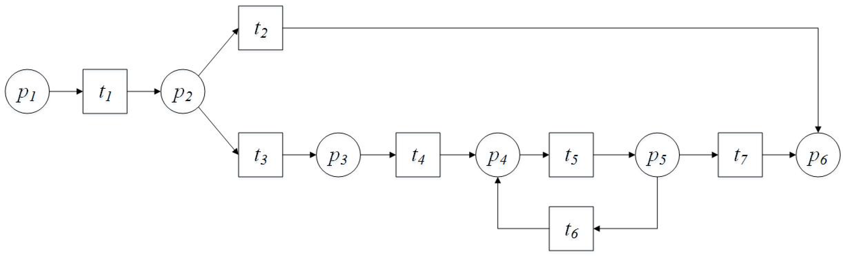
3.3. Workflow Routing Structures
3.4. Validity of GCWF-Net
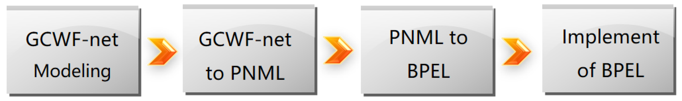
4. Implement of GCWF-Net
4.1. GCWF-Net Modeling
4.2. Representation of GCWF-Net in PNML
4.3. Conversion from PNML to BPEL
- (1)
- Variables in GCWF-net correspond to the variables in BPEL; the names of variables in BPEL are automatically generated according to the conventional way of naming.
- (2)
- G and B are the semantic expressions of guard function and operation methods set for geospatial constraint. The methods set corresponds to the geographic information services set, and spatial operation needs geographic information service combination.
4.4. Implementation of BPEL
5. Conclusions
- (1)
- Discussing specific geographic spatial constraint method models is required, so the next work is to carry out a detailed analysis for this content;
- (2)
- Designing algorithms to analyze properties of GCWF-net will be necessary, such as validation, verification, performance, etc.
- (3)
- Developing an application system using the GCWF-net.
Acknowledgments
Author Contributions
Conflicts of Interest
Abbreviations
| GCNet | Geospatial Constraints Net |
| GCWF-net | Geospatially Constrained Workflow Model |
| WF-net | Workflow net |
| PNML | Petri Net Markup Languag |
| BPEL | Web Service Business Process Execution Language |
References
- Hollingsworth, D. Workflow Management Coalition the Workflow Reference Model. Available online: http://www.e-workflow.org/standards/ (accessed on 25 November 2015).
- Born, M.; Kirchner, J.; Muller, J.P. Context-driven business process modeling. In Proceedings of the 1st International Workshop on Managing Data with Mobile Devices (MDMD 2009), Milan, Italy, 6–7 May 2009; pp. 6–10.
- Chakraborty, D.; Lei, H. Pervasive enablement of business processes. Perv. Mob.Comput. 2004, 87–97. [Google Scholar] [CrossRef]
- Wieland, M.; Kopp, O.; Nicklas, D.; Leymann, F. Towards context-aware workflows. Available online: http://www-iaas.informatik.uni-stuttgart.de/RUS-data/INPROC-2007-18%20-%20Context4BPEL.pdf (accessed on 25 May 2016).
- De Leoni, M.; Adams, M.; Van Der Aalst, W.M.; Ter Hofstede, A.H. Visual support for work assignment in process- aware information systems: Framework formalisation and implementation. Decis. Support Syst. 2012, 54, 345–361. [Google Scholar] [CrossRef]
- Decker, M. Modelling location-aware access control constraints for mobile workflows with uml activity diagrams. Ubiquitous Comput. Syst. 2009, 263–268. [Google Scholar] [CrossRef]
- Che, H.; Decker, M. Anomalies in business process models for mobile scenarios with location constraints. In Proceedings of the International Conference on Automation and Logistics, Hong Kong, China, 16–20 August 2010; pp. 306–313.
- Zhang, L.; Zhao, J.; Jia, W.H.; Liu, Y.B. Location-aware workflow modeling and soundness verification method based on petri net. Comput. Integr. Manuf. Syst. 2012, 18, 1747–1756. [Google Scholar]
- Zhu, G.; Zhu, X. A study on geospatial constrained process modeling using uml activity diagrams. Asia Pac. Bus. Process Manag. 2014, 181, 59–73. [Google Scholar]
- Zhu, X.W.; Zhu, G.B. Business process modeling with geospatial constraints. J. Softw. 2015, 26, 584–599. [Google Scholar]
- Sackmann, S.; Hofmann, M.; Betke, H. Towards a Model-Based Analysis of Place-Related Information in Disaster Response Workflows. In Proceedings of the 10th International Conference on Information Systems for Crisis Response and Management, Baden-Baden, Germany, 12–15 May 2013; pp. 78–83.
- Hofmann, M.; Betke, H.; Sackmann, S. Automated analysis and adaptation of disaster response processes with place-related restrictions. In Proceedings of the 12th International Conference on Information Systems for Crisis Response and Management (ISCRAM 2015), Kristiansand, Norway, 24–27 May 2015.
- Weber, M.; Kindler, E. The petri net markup language. In Petri Net Technology for Communication-Based Systems; Springer: Berlin/Heidelberg, Germany, 2003; pp. 124–144. [Google Scholar]
- Wu, X.C. Principles and Methods of Geographical Information System, 2nd ed.; Publishing House of Electronics Industry: Beijing, China, 2011; pp. 3–4. (In Chinese) [Google Scholar]
- Yuan, C.Y. Application of Petri Nets; Science Press: Beijing, China, 2013; pp. 119–139. (In Chinese) [Google Scholar]
- Kindle, E. The Petri Net Markup Language and ISO/IEC 15909-2: Concepts, status, and future directions. Tech. Rep. 2006, 9, 35–55. [Google Scholar]
- Van der Aalst, W.M. The application of petri nets to workflow management. J. Circuits Syst. Comput. 1998, 8, 21–66. [Google Scholar] [CrossRef]
- Billington, J.; Christensen, S.; Hee, K.V.; Kindler, E.; Kummer, O.; Petrucc, L.; Post, R.; Stehno, C.; Weber, M. The Petri Net markup language: Concepts, technology, and tools. Appl. Theory Petri Nets 2003, 2679, 483–505. [Google Scholar]
- Van der Aalst, W.M.; Lassen, K.B. Translating Workflow Nets to BPEL. Available online: http://cms.ieis.tue.nl/beta/files/workingpapers/beta_wp145.pdf (accessed on 25 May 2016).
- Lassen, K.B.; Van der Aalst, W.M. WorkflowNet2BPEL4WS: A tool for translating unstructured workflow processes to readable BPEL. Move Mean. Intern. Syst. 2006, 4275, 127–144. [Google Scholar]

© 2016 by the authors; licensee MDPI, Basel, Switzerland. This article is an open access article distributed under the terms and conditions of the Creative Commons Attribution (CC-BY) license (http://creativecommons.org/licenses/by/4.0/).
Share and Cite
Zhang, F.; Xu, Y. Geospatially Constrained Workflow Modeling and Implementation. Information 2016, 7, 30. https://doi.org/10.3390/info7020030
Zhang F, Xu Y. Geospatially Constrained Workflow Modeling and Implementation. Information. 2016; 7(2):30. https://doi.org/10.3390/info7020030
Chicago/Turabian StyleZhang, Feng, and Yuetong Xu. 2016. "Geospatially Constrained Workflow Modeling and Implementation" Information 7, no. 2: 30. https://doi.org/10.3390/info7020030
APA StyleZhang, F., & Xu, Y. (2016). Geospatially Constrained Workflow Modeling and Implementation. Information, 7(2), 30. https://doi.org/10.3390/info7020030