From Data to Decision: A Semantic and Network-Centric Approach to Urban Green Space Planning
Abstract
1. Introduction
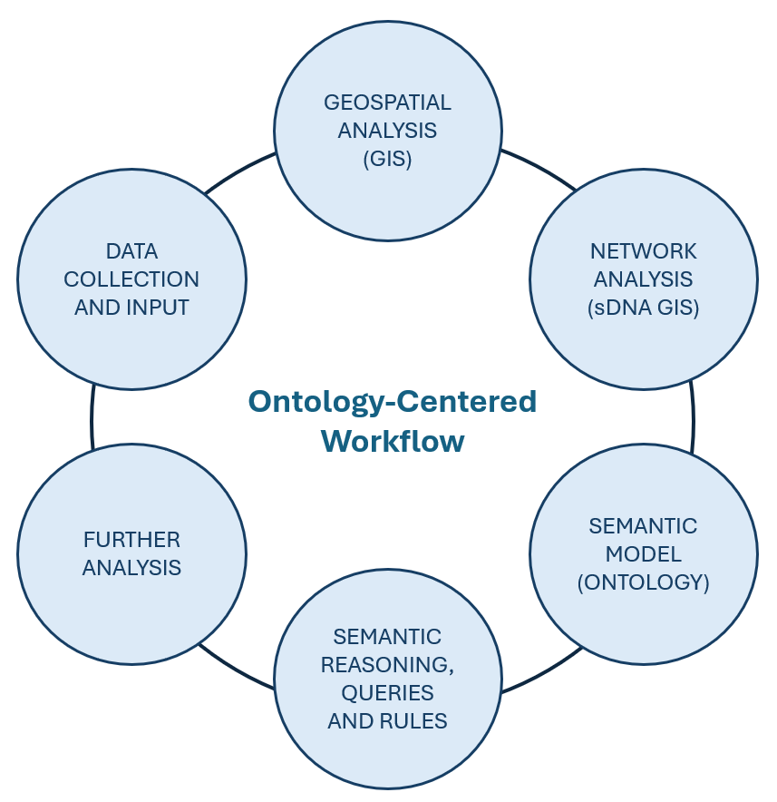
2. Conceptual and Methodological Background: Toward an Integrated Planning Framework
- •
- Spatial properties of parks and streets from GIS datasets;
- •
- Street network metrics (e.g., centrality from graph theory);
- •
- Regulatory constraints from zoning and planning rules.
3. Data Disclaimer and Methodological Decisions
4. Methodology: Ontology and Network-Based Spatial Analysis
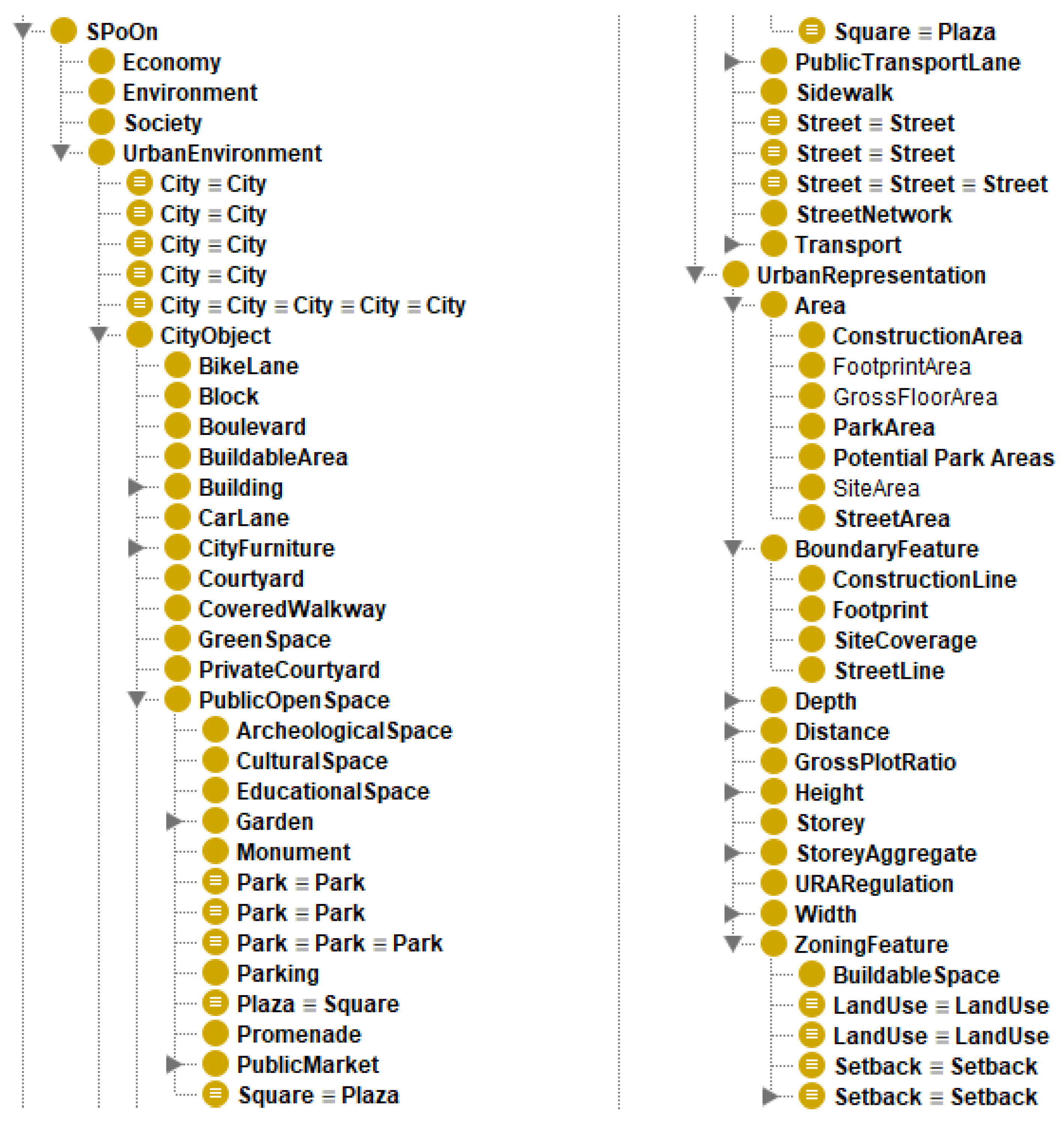
4.1. Ontology Design: Building Sustainable Polis Ontology (SPoOn)
- •
- City Objects: These represent the physical components of the urban fabric, such as streets, blocks, parks, and buildings.
- •
- Urban Representations: These are used to model regulatory or conceptual entities such as construction lines, zoning boundaries, and setback limits.
- •
- Properties for Analysis: SPoOn incorporates geometric (e.g., hasArea, hasCentroid), topological (e.g., includes), network-based (e.g., hasBetweenness_max, hasConnectivity), and informational (e.g., hasName, hasAddress) properties to support a wide range of spatial and semantic operations.
- •
- Populated Instances: Real-world individuals (parks, streets, regulation areas) are added to the ontology through automated scripts parsing GIS outputs, spatial metrics, and regulatory shapefiles.
4.2. Network and Spatial Analysis in GIS
4.2.1. Data Preparation and Processing
4.2.2. Network Analysis Using sDNA
- •
- Betweenness Centrality: This metric identifies streets with high through-movement potential, which are likely to attract traffic flows.
- •
- Closeness Centrality: This measures how accessible a street is in terms of average distance to all other nodes in the network.
- •
- Local Angular Connectivity (LAC): This metric evaluates the degree of local integration within a specified radius, reflecting neighborhood-level walkability.
4.2.3. Assigning Street-Based Metrics to Parks
4.2.4. Spatial Attributes and Preliminary Analysis
4.3. Translating GIS Data into Ontology
- •
- Parks were instantiated as individuals of the class Park, with data properties corresponding to attributes such as area, hub distance, maximum betweenness, and other spatial, network-derived metrics or OSM-derived attributes;
- •
- Street segments were instantiated as individuals of the class Street, carrying properties including length, sDNA, and OSM values;
- •
- Regulatory lines and planning boundaries were instantiated as individuals of corresponding classes (e.g., BuildingLine, StreetLine, UncoveredSpaceBoundary), populated with their official attributes sourced from the Epoleodomia GIS portal [61].
4.4. Semantic Queries and Analysis
4.4.1. SPARQL Queries for Urban Network Analysis
- •
- Accessibility and Connectivity Patterns: Queries retrieved parks exhibiting low local connectivity (?LConn), low link counts (?Lnkn), and large distances to network hubs (?HubDist). This allowed the identification of potentially underserved green spaces;
- •
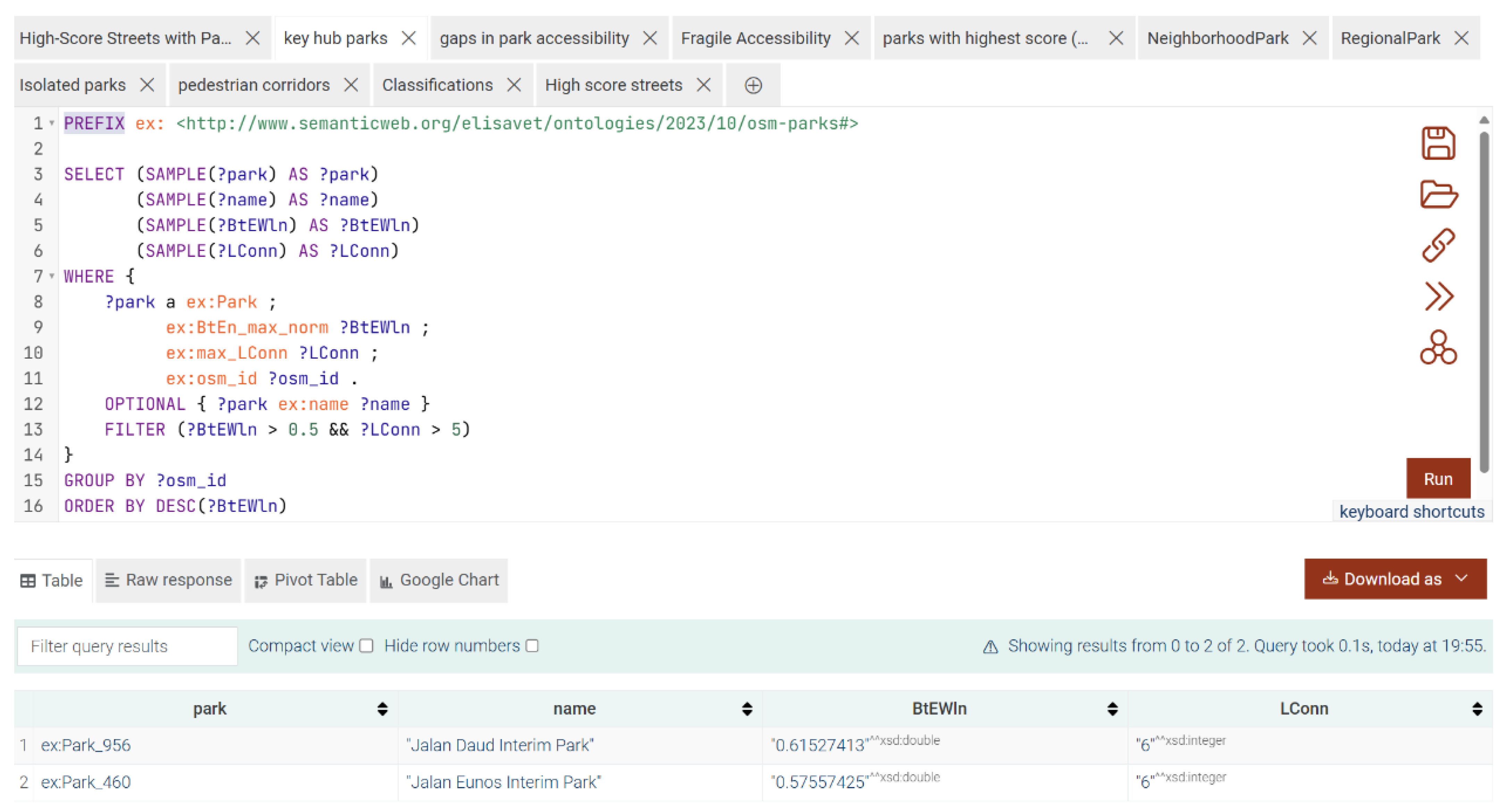
- Network Hubs: Parks characterized by both high betweenness centrality and high local connectivity were queried, revealing critical hubs within the UGS network;
- •
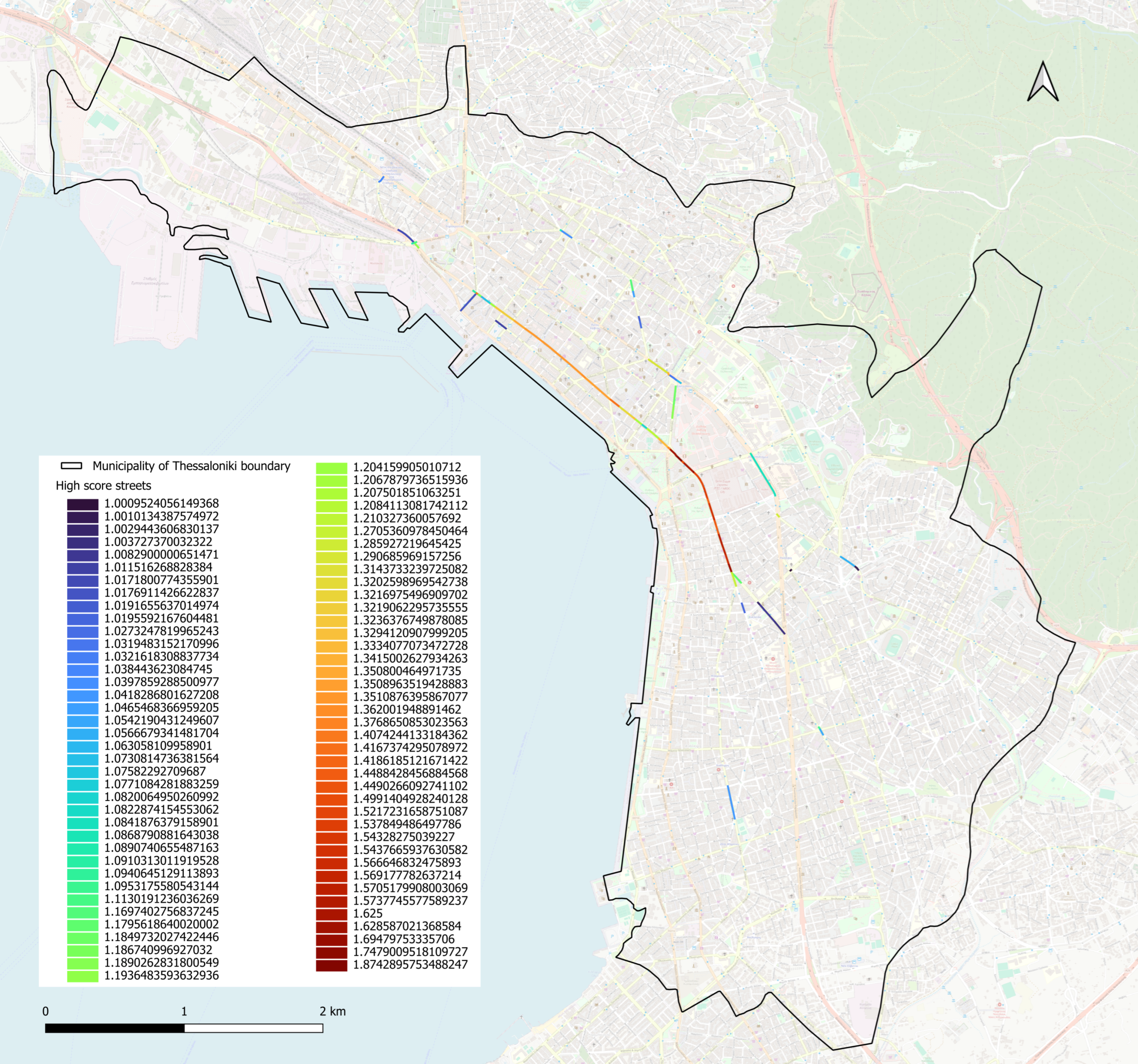
- Composite Scoring: To evaluate and prioritize parks based on their network performance, we computed a composite score (Score) integrating three normalized centrality metrics: local connectivity (normLConn), betweenness centrality (normBtEWln), and hub distance (normHubDist). The composite score was derived using the following weighted linear combination:where the additive terms (normLConn, normBtEWln) capture positive contributions of network accessibility and throughput, while the subtractive term (normHubDist) penalizes remoteness from major activity hubs. Normalization ensured comparability across metrics by scaling all values to a common range prior to aggregation.Score = normLConn + normBtEWln − normHubDist,
- •
- Spatial Typologies: Park categories were identified by querying spatial characteristics such as area, centralities, and adjacency to street networks, informing classification (later formalized through SWRL rules).
4.4.2. Rule-Based Typological Classification (SWRL)
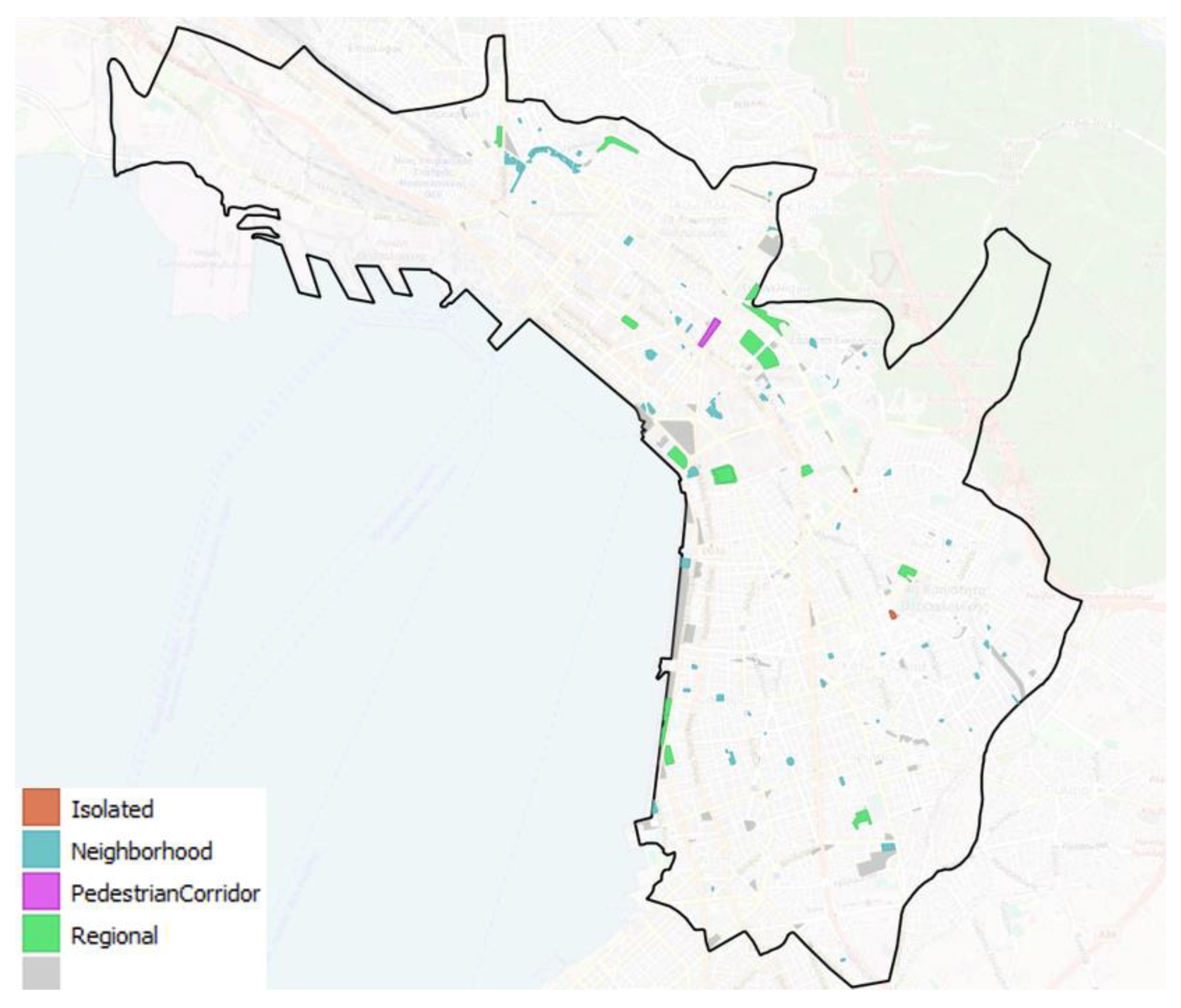
This rule assigns the data property isIsolated to parks meeting two criteria: (1) a hub distance exceeding 1500 m and (2) fewer than 2.0 connecting links. These thresholds were selected to operationalize spatial isolation, capturing parks that are both peripherally located and poorly integrated into the urban network. The SWRL engine dynamically infers this classification during reasoning, enabling automated identification of isolated green spaces.swrlb:greaterThan(?hub,1500)∧spoon:Park(?p)∧spoon:HubDist(?p,?hub)∧spoon:Lnkn_Cl_ma(?p,?Lnkn)∧swrlb:lessThan(?Lnkn,2.0)→spoon:isIsolated(?p,”yes”)swrlb:greaterThan(?hub,1500)∧spoon:Park(?p)∧spoon:HubDist(?p,?hub)∧spoon:Lnkn_Cl_ma(?p,?Lnkn)∧swrlb:lessThan(?Lnkn,2.0)→spoon:isIsolated(?p,”yes”)
4.4.3. Semantic Modeling of Regulation Areas and Identification of Potential Parks
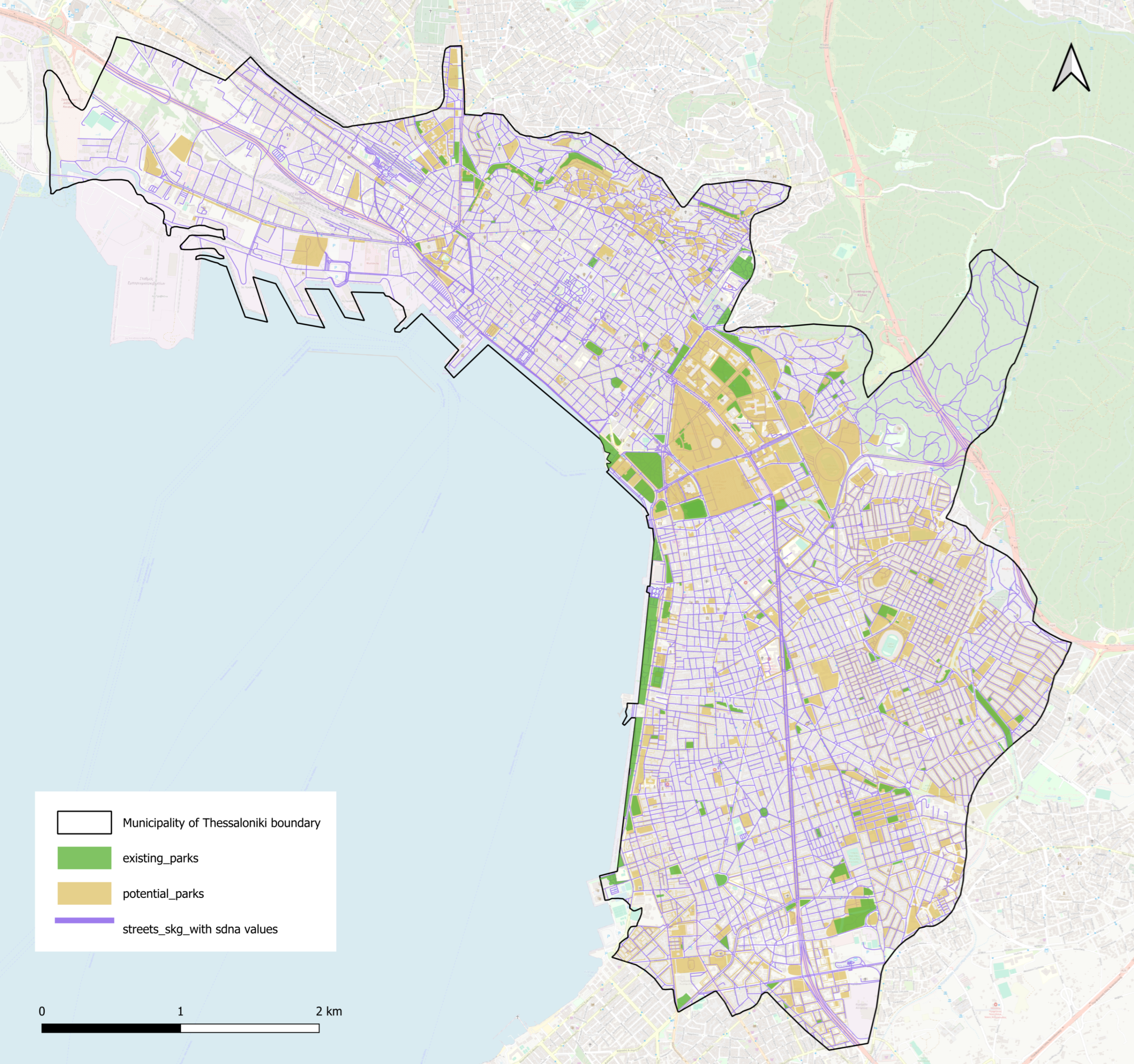
Data Preparation and Polygon Generation
- •
- Street boundaries were buffered and merged into closed polygons to create StreetAreas and ConstructionAreas;
- •
- Construction zones were subtracted from enclosed street areas to create park areas. Candidate ParkAreas were calculated as follows:
- Exclusion of Existing Parks
- Semantic Translation
Querying and Prioritization
- •
- Located near (within 500-m distance) high-scoring streets (based on composite network metrics with score higher than 1);
- •
- Satisfied size (minimum 50 m2 area) and zoning conditions inferred from the regulatory data (is ParkArea).
4.4.4. Iterative Feedback Between Querying, Reasoning, and Ontology Evolution
- •
- Missing or imprecise property definitions;
- •
- The need for new classes or subclasses;
- •
- The necessity to introduce new object or data properties.
5. Implementation and Testing in Distinct Contexts
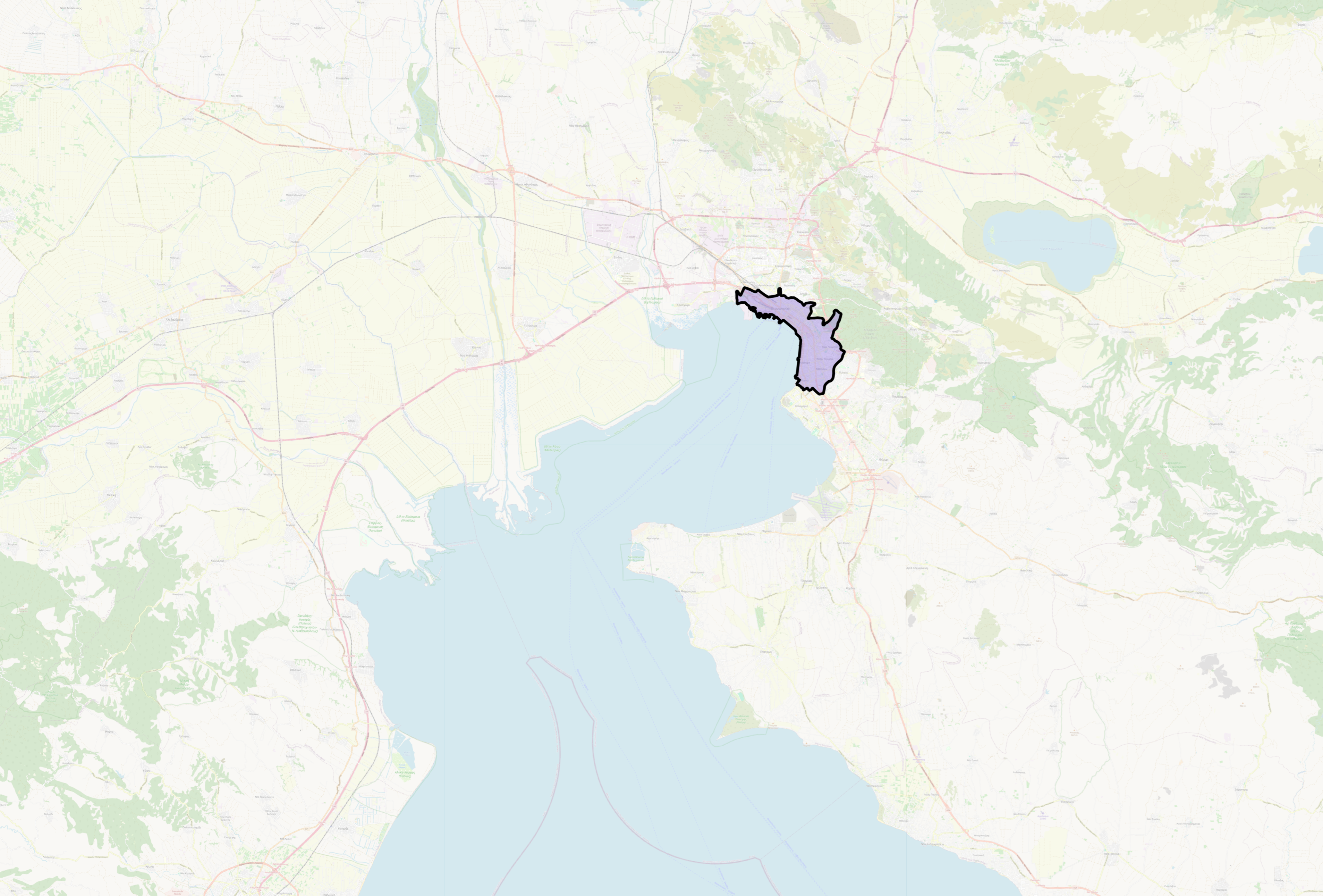
5.1. Core Implementation: Municipality of Thessaloniki (Greece)
5.1.1. Network-Based Findings
5.1.2. Park Classifications and Regulatory Context
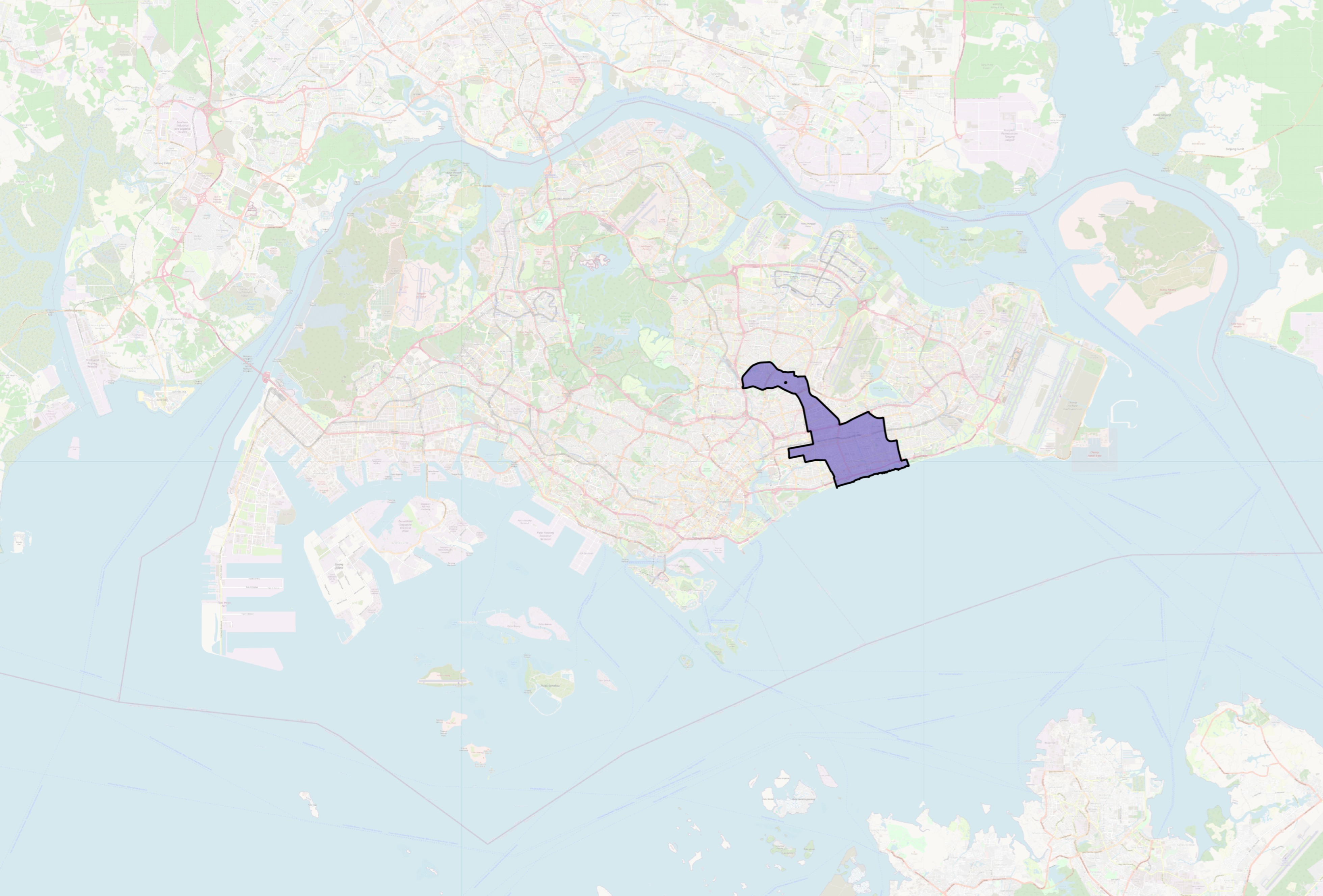
5.2. Testing in a Different Context: Marine Parade GRC (Singapore)
6. Insights and Implications for Urban Planning
- •
- Detection of spatial blind spots, where parks were poorly integrated, under-connected, or legally constrained;
- •
- Recognition of high-performing spatial configurations, where parks aligned with central corridors or supported broader accessibility patterns;
- •
- Identification of actionable opportunities, particularly in Thessaloniki, where regulatory data enabled semantic reasoning to reveal developable green zones.
- Problem detection: The model reveals where urban green systems are disconnected, undersized, or misaligned with street networks, diagnosing inefficiencies that would be difficult to perceive through static spatial layers alone.
- Pattern recognition and opportunity identification: By surfacing recurring spatial logics, such as the co-location of parks with highly integrated street segments, the methodology supports replication of successful configurations. Moreover, it enables the semantic filtering of candidate areas for intervention, based on zoning status, area thresholds, and network proximity.
7. Conclusions and Future Work
Supplementary Materials
Author Contributions
Funding
Data Availability Statement
Conflicts of Interest
Abbreviations
| OSM | OpenStreetMap |
| sDNA | Spatial Design Network Analysis |
| SPoOn | Sustainable Polis Ontology |
| TWA | The World Avatar |
| UGS | Urban green space |
| WKT | Well-known text |
References
- Jameson, S.; Baud, I.; Peyroux, E.; Scott, D. The urban governance configuration: A conceptual framework for understanding complexity and enhancing transitions to greater sustainability in cities. Geogr. Compass 2021, 15, e12562. [Google Scholar] [CrossRef]
- Latinopoulos, D. Evaluating the importance of urban green spaces: A spatial analysis of citizens’ perceptions in Thessaloniki. Euro-Mediterr. J. Environ. Integr. 2022, 7, 299–308. [Google Scholar] [CrossRef] [PubMed]
- Totsikas, I.; Katsavounidou, G. Experienced affordances of urban green spaces in comparison with planning standards. E3S Web Conf. 2023, 436, 12008. [Google Scholar] [CrossRef]
- Wang, Y.; Wang, T.; Zhang, Y.; Zhang, H.; Zheng, H.; Zheng, G.; Kong, L. UrbanDataLayer: A unified data pipeline for urban science. In Proceedings of the 38th International Conference on Neural Information Processing Systems (NIPS ’24), Vancouver BC Canada, 10–15 December 2024; Article 233. Curran Associates Inc.: Red Hook, NY, USA, 2025; Volume 37, pp. 7296–7310. [Google Scholar]
- Al Sawafi, M. Geoinformation Technologies in Urban Planning; Belgorod State Technological University named after V. G. Shukhov: Belgorod, Russian, 2021; Volume 6, pp. 52–62. [Google Scholar] [CrossRef]
- Binopoulos, A.; Evangelidou, E.; Vlachopanagiotis, T.; Grizos, K. A Network Analysis Model to Measure the Walkability of Public Spaces. In Proceedings of the Smart Energy for Smart Transport; Nathanail, E.G., Gavanas, N., Adamos, G., Eds.; Springer Nature: Cham, Switzerland, 2023; pp. 1121–1134. [Google Scholar]
- Gil, J.; Varoudis, T.; Karimi, K. The Space Syntax Toolkit: Integrating depthmapX and Exploratory Spatial Analysis Workflows in QGIS; University College London: London, UK, 2015. [Google Scholar]
- Reza, S.; Machado, J.; Tavares, J. Analysis of the Structure of the Road Networks: A Network Science Perspective; Springer: Berlin/Heidelberg, Germany, 2022. [Google Scholar]
- Milenković, A.; Miličević, M.; Čugalj, R.; Dmitrović, V. Contemporary methods of presenting planning solutions using GIS. Appl. Comput. Eng. 2024, 65, 457–464. [Google Scholar] [CrossRef]
- Kuster, C.; Hippolyte, J.-L.; Rezgui, Y. The UDSA ontology: An ontology to support real time urban sustainability assessment. Adv. Eng. Softw. 2020, 140, 102731. [Google Scholar] [CrossRef]
- Ubbiali, G.A.; Borghini, A.; Lange, M.C. Ontologies for Sustainability: Theoretical Challenges. Open Sci. Framew. 2024. [Google Scholar] [CrossRef]
- Fonseca, F.T.; Egenhofer, M.J.; Agouris, P.; Câmara, G. Using ontologies for integrated geographic information systems. Trans. GIS 2002, 6, 231–257. [Google Scholar] [CrossRef]
- Silvennoinen, H.; Chadzynski, A.; Farazi, F.; Grisiute, A.; Shi, Z.; von Richthofen, A.; Cairns, S.D.; Kraft, M.; Raubal, M.; Herthogs, P. A semantic web approach to land use regulations in urban planning: The OntoZoning ontology of zones, land uses and programmes for Singapore. J. Urban Manag. 2023, 12, 151–167. [Google Scholar] [CrossRef]
- Srikanth, A.D.; Schroepfer, T. Network Science-based Analysis of Urban Green Spaces in Singapore. Int. J. Smart Sustain. Cities 2023, 1, 2340004. [Google Scholar] [CrossRef]
- Kmail, A.; Onyango, V. A GIS-based assessment of green space accessibility: Case study of Dundee. Appl. Geomat. 2020, 12, 135–147. [Google Scholar] [CrossRef]
- Teimouri, R.; Karuppannan, S.; Sivam, A.; Gu, N.; Abyaneh, A.B. Investigation of urban green space (UGS) accessibility in Adelaide metropolitan area using network analyst. Int. Arch. Photogramm. Remote Sens. Spatial Inf. Sci. 2022, 48, 183–190. [Google Scholar] [CrossRef]
- Batty, M. Cities and Complexity: Understanding Cities with Cellular Automata, Agent-Based Models, and Fractals; MIT Press: Cambridge, MA, USA, 2005. [Google Scholar]
- Bettencourt, L.M.A. The origins of scaling in cities. Science 2013, 340, 1438–1441. [Google Scholar] [CrossRef]
- Portugali, J. Complexity, Cognition and the City; Springer: Berlin/Heidelberg, Germany, 2011. [Google Scholar]
- UN-Habitat. World Cities Report 2020: The Value of Sustainable Urbanization; UN-Habitat: Nairobi, Kenya, 2020. [Google Scholar]
- Rittel, H.W.J.; Webber, M.M. Dilemmas in a general theory of planning. Policy Sci. 1973, 4, 155–169. [Google Scholar] [CrossRef]
- Kabisch, N.; Qureshi, S.; Haase, D. Human–environment interactions in urban green spaces—A systematic review of contemporary issues and prospects for future research. Environ. Impact Assess. Rev. 2015, 50, 25–34. [Google Scholar] [CrossRef]
- Wolch, J.R.; Byrne, J.; Newell, J.P. Urban green space, public health, and environmental justice: The challenge of making cities ‘just green enough’. Landsc. Urban Plan. 2014, 125, 234–244. [Google Scholar] [CrossRef]
- de Roo, G.; Yamu, C.; Zuidema, C. (Eds.) Handbook on Planning and Complexity; Research handbooks in planning; Edward Elgar Publishing: Cheltenham, UK; Northampton, MA, USA, 2020; ISBN 978-1-78643-917-8. [Google Scholar]
- Biljecki, F.; Chew, L.Z.X.; Milojevic-Dupont, N.; Creutzig, F. Open government geospatial data on buildings for planning sustainable and resilient cities. arXiv 2021, arXiv:2107.04023. [Google Scholar] [CrossRef]
- Berners-Lee, T.; Hendler, J.; Lassila, O. The Semantic Web. Sci. Am. 2001, 284, 28–37. [Google Scholar] [CrossRef]
- Bardis, G. A Declarative Modeling Framework for Intuitive Multiple Criteria Decision Analysis in a Visual Semantic Urban Planning Environment. Electronics 2024, 13, 4845. [Google Scholar] [CrossRef]
- Patano, M.; Camarda, D. Managing Complex Knowledge in Sustainable Planning: A Semantic-Based Model for Multiagent Water-Related Concepts. Sustainability 2023, 15, 11774. [Google Scholar] [CrossRef]
- Torzoni, S.; Pisano, C.; Battisti, F. Form and Structure of the Knowledge Framework for Urban Planning: Methodological Approach and Assessment Issues: The Case Study of the Municipality of Fondi Urban Plan. Land 2023, 12, 1201. [Google Scholar] [CrossRef]
- Antoniou, P.E.; Chondrokostas, E.; Bratsas, C.; Filippidis, P.-M.; Bamidis, P.D. A Medical Ontology Informed User Experience Taxonomy to Support Co-creative Workflows for Authoring Mixed Reality Medical Education Spaces. In Proceedings of the 2021 7th International Conference of the Immersive Learning Research Network (iLRN), Eureka, CA, USA, 17 May–10 June 2021; pp. 1–9. [Google Scholar]
- Bratsas, C.; Kapsas, G.; Konstantinidis, S.; Koutsouridis, G.; Bamidis, P.D. A semantic wiki within moodle for Greek medical education. In Proceedings of the 2009 22nd IEEE International Symposium on Computer-Based Medical Systems, Albuquerque, NM, USA, 2–5 August 2009; pp. 1–6. [Google Scholar]
- Bratsas, C.; Koutkias, V.; Kaimakamis, E.; Bamidis, P.; Maglaveras, N. Ontology-based Vector Space Model and Fuzzy Query Expansion to Retrieve Knowledge on Medical Computational Problem Solutions. In Proceedings of the 2007 29th Annual International Conference of the IEEE Engineering in Medicine and Biology Society, Lyon, France, 22–26 August 2007; pp. 3794–3797. [Google Scholar]
- Spyropoulos, A.Z.; Bratsas, C.; Makris, G.C.; Garoufallou, E.; Tsiantos, V. Interoperability-Enhanced Knowledge Management in Law Enforcement: An Integrated Data-Driven Forensic Ontological Approach to Crime Scene Analysis. Information 2023, 14, 607. [Google Scholar] [CrossRef]
- Spyropoulos, A.Z.; Kornilakis, A.; Makris, G.C.; Bratsas, C.; Tsiantos, V.; Antoniou, I. Semantic Representation of the Intersection of Criminal Law & Civil Tort. Data 2022, 7, 176. [Google Scholar] [CrossRef]
- Filippidis, P.-M.; Dimoulas, C.; Bratsas, C.; Veglis, A. A unified semantic sports concepts classification as a key device for multidimensional sports analysis. In Proceedings of the 2018 13th International Workshop on Semantic and Social Media Adaptation and Personalization (SMAP), Zaragoza, Spain, 6–7 September 2018; pp. 107–112. [Google Scholar]
- Karampatakis, S.; Bratsas, C.; Zamazal, O.; Filippidis, P.M.; Antoniou, I. Alignment: A Hybrid, Interactive and Collaborative Ontology and Entity Matching Service. Information 2018, 9, 281. [Google Scholar] [CrossRef]
- Bratsas, C.; Chrysou, D.E.; Eftychiadou, A.; Kontokostas, D.; Bamidis , P.; Antoniou , I. Semantic Web Game Based Learning: An I18n approach with Greek DBpedia. In Proceedings of the 2nd International Workshop on Learning and Education with the Web of Data (LiLe-2012 at WWW-2012), CEUR Workshop Proceedings Vol 840, Lyon, France, 17 April 2012. [Google Scholar]
- Kontokostas, D.; Bratsas, C.; Auer, S.; Hellmann, S.; Antoniou, I.; Metakides, G. Internationalization of Linked Data: The case of the Greek DBpedia edition. J. Web Semant. 2012, 15, 51–61. [Google Scholar] [CrossRef]
- Lange, C.; Ion, P.; Dimou, A.; Bratsas, C.; Sperber, W.; Kohlhase, M.; Antoniou, I. Bringing Mathematics to the Web of Data: The Case of the Mathematics Subject Classification. In Proceedings of the The Semantic Web: Research and Applications; Simperl, E., Cimiano, P., Polleres, A., Corcho, O., Presutti, V., Eds.; Springer: Berlin/Heidelberg, Germany, 2012; pp. 763–777. [Google Scholar]
- Bratsas, C.; Chondrokostas, E.; Koupidis, K.; Antoniou, I. The Use of National Strategic Reference Framework Data in Knowledge Graphs and Data Mining to Identify Red Flags. Data 2021, 6, 2. [Google Scholar] [CrossRef]
- Von Richthofen, A.; Herthogs, P.; Kraft, M.; Cairns, S. Semantic City Planning Systems (SCPS): A Literature Review. J. Plan. Lit. 2022, 37, 415–432. [Google Scholar] [CrossRef]
- Pauwels, P.; Van Deursen, D.; Verstraeten, R.; De Roo, J.; De Meyer, R.; Van De Walle, R.; Van Campenhout, J. A semantic rule checking environment for building performance checking. Autom. Constr. 2011, 20, 506–518. [Google Scholar] [CrossRef]
- Lee, J.; Song, J. Towards Semantic Smart Cities: A Study on the Conceptualization and Implementation of Semantic Context Inference Systems. Sensors 2023, 23, 9392. [Google Scholar] [CrossRef]
- CityGML Standard|OGC Publications. Open Geospatial Consortium. Available online: https://www.ogc.org/standards/citygml (accessed on 13 August 2025).
- The World Avatar. Available online: https://theworldavatar.io/ (accessed on 13 August 2025).
- Jiang, B.; Claramunt, C. Topological analysis of urban street networks. Environ. Plan. B Plan. Des. 2004, 31, 151–162. [Google Scholar] [CrossRef]
- Porta, S.; Crucitti, P.; Latora, V. The network analysis of urban streets: A dual approach. Phys. A Stat. Mech. Its Appl. 2006, 369, 853–866. [Google Scholar] [CrossRef]
- Barbosa, O.; Tratalos, J.A.; Armsworth, P.R.; Davies, R.G.; Fuller, R.A.; Johnson, P.; Gaston, K.J. Who benefits from access to green space? A case study from Sheffield, UK. Landsc. Urban Plan. 2007, 83, 187–195. [Google Scholar] [CrossRef]
- Kalwar, S.; Sahito, N.; Das, G.; Brohi, S.; Tahiri, A.G.; Memon, I.A. Public parks accessibility analysis through GIS: A case study of Tanddo Allahyar City. IJESD 2021, 1, 1. [Google Scholar] [CrossRef]
- Kropf The handbook of urban morphology. Urban Morphol. 2017, 22, 86–87. [CrossRef]
- Hillier, B.; Hanson, J. The Social Logic of Space; Cambridge University Press: Cambridge, UK, 1984. [Google Scholar]
- Lee, D.H.; Chamberlain, B.; Park, H.Y. Toward a Construct-Based Definition of Urban Green Space: A Literature Review of the Spatial Dimensions of Measurement, Methods, and Exposure. Land 2025, 14, 517. [Google Scholar] [CrossRef]
- Tan, P.Y.; Wang, J.; Sia, A. Perspectives on five decades of urban greenery in Singapore. Cities 2013, 32, 24–32. [Google Scholar] [CrossRef]
- Zhang, X.; He, Y. What Makes Public Space Public? The Chaos of Public Space Definitions and a New Epistemological Approach. Adm. Soc. 2020, 52, 749–770. [Google Scholar] [CrossRef]
- Multi-Functional Green and Blue Spaces. Available online: https://www.ura.gov.sg/Corporate/Planning/Long-Term-Plan-Review/Space-for-Our-Dreams-Exhibition/Steward/Multi-Functional-Green-and-Blue (accessed on 20 May 2025).
- Athanassiou, E.; Kapsali, M. Infiltration of Private Sector in Thessaloniki’s Public Space. Κοινωνικός Άτλας Θεσσαλονίκης. Available online: https://thessalonikisocialatlas.arch.auth.gr/en/items/i-dieisdysi-tou-idiotikou-tomea-ston-dimosio-choro-tis-thessalonikis/ (accessed on 13 August 2025).
- Karagianni, M. Green Public Spaces in Thessaloniki. Thessaloniki Social Atlas. 2024. Available online: https://thessalonikisocialatlas.arch.auth.gr/en/items/dimosioi-choroi-prasinou-sto-poleodomiko-sygkrotima-thessalonikis/ (accessed on 13 August 2025).
- Pozoukidou, G. Designing a green infrastructure network for metropolitan areas: A spatial planning approach. Euro-Mediterr. J. Environ. Integr. 2020, 5, 40. [Google Scholar] [CrossRef]
- Fan, H.; Zipf, A.; Fu, Q.; Neis, P. Quality assessment for building footprints data on OpenStreetMap. Int. J. Geogr. Inf. Sci. 2014, 28, 700–719. [Google Scholar] [CrossRef]
- Open Data in Europe 2024. Available online: https://data.europa.eu/en/publications/open-data-maturity/2024 (accessed on 17 May 2025).
- Ministry of Environment and Energy e-Poleodomia GIS Portal. Available online: https://gis.epoleodomia.gov.gr/v11/index.html (accessed on 13 August 2025).
- OECD/International Transport Forum Advancing Sustainable Mobility Through SUMP Implementation in Greece: Full Report. 2023. Available online: https://www.itf-oecd.org/sites/default/files/advancing-sustainable-mobility-greece-sumps-full_en.pdf (accessed on 13 August 2025).
- Giezen, M.; Scholten, H.J. Digital twins in spatial planning: Case study of Singapore’s Urban Redevelopment Authority. Comput. Environ. Urban Syst. 2021, 87, 101598. [Google Scholar]
- Urban Redevelopment Authority URA Space: Integrated Map Services Portal. Available online: https://eservice.ura.gov.sg/maps (accessed on 13 August 2025).
- Singapore Land Authority OneMap: Singapore’s National Map. Available online: https://www.onemap.gov.sg (accessed on 13 August 2025).
- OpenStreetMap Contributors OpenStreetMap. Available online: https://www.openstreetmap.org (accessed on 13 August 2025).
- Barron, C.; Neis, P.; Zipf, A. A comprehensive framework for intrinsic OpenStreetMap quality analysis. Trans. GIS 2014, 18, 877–895. [Google Scholar] [CrossRef]
- Haklay, M. How good is volunteered geographical information? A comparative study of OpenStreetMap and Ordnance Survey datasets. Environ. Plan. B Plan. Des. 2010, 37, 682–703. [Google Scholar] [CrossRef]
- Mooney, P.; Corcoran, P. The annotation process in OpenStreetMap. Trans. GIS 2012, 16, 561–579. [Google Scholar] [CrossRef]
- Senaratne, H.; Mobasheri, A.; Ali, A.L.; Capineri, C.; Haklay, M. A review of volunteered geographic information quality assessment methods. Int. J. Geogr. Inf. Sci. 2017, 31, 139–167. [Google Scholar] [CrossRef]
- Sieber, R.; Robinson, P.; Johnson, P.A.; Corbett, J. Doing Public Participation on the Geospatial Web. Can. Geogr. 2016, 60, 7–19. [Google Scholar] [CrossRef]
- Kitchin, R. The real-time city? Big data and smart urbanism. GeoJournal 2014, 79, 1–14. [Google Scholar] [CrossRef]
- Leszczynski, A. Spatial big data and anxieties of control. Environ. Plan. D Soc. Space 2014, 32, 965–984. [Google Scholar] [CrossRef]
- Evans, J.; Karvonen, A.; Raven, R. The Experimental City; Routledge: London, UK, 2022. [Google Scholar]
- Pereira, G.V.; Macadar, M.A.; Luciano, E.M. E-government and governance: A framework for using data for policy-making. Gov. Inf. Q. 2017, 34, 480–492. [Google Scholar]
- Karimi, K. Urban Intelligence and Spatial Planning in the Age of Big Data. Built Environ. 2020, 46, 336–354. [Google Scholar]
- Arribas-Bel, D.; Reades, J. Urban analytics: Spatial data science for cities. Geogr. Anal. 2018, 50, 3–17. [Google Scholar]
- Lutz, M.; Sprado, J.; Klien, E.; Schubert, C.; Christ, I. Overcoming Semantic Heterogeneity in Spatial Data Infrastructures. Comput. Environ. Urban Syst. 2009, 33, 134–144. [Google Scholar] [CrossRef]
- De Nicola, A.; Villani, M.L. Smart City Ontologies and Their Applications: A Systematic Literature Review. Sustainability 2021, 13, 5578. [Google Scholar] [CrossRef]
- Akroyd, J.; Mosbach, S.; Bhave, A.; Kraft, M. Universal Digital Twin—A Dynamic Knowledge Graph. Data-Centric Eng. 2021, 2, e14. [Google Scholar] [CrossRef]
- Chadzynski, A.; Li, S.; Grisiute, A.; Farazi, F.; Lindberg, C.; Mosbach, S.; Herthogs, P.; Kraft, M. Semantic 3D City Agents—An intelligent automation for dynamic geospatial knowledge graphs. Energy AI 2022, 8, 100137. [Google Scholar] [CrossRef]
- Hellenic Ministry for Urban Planning Introduction Guide to e-Πολεοδομία Services. Available online: http://gis.epoleodomia.gov.gr/v11/%CE%A7%CE%A1%CE%89%CE%A3%CE%A4%CE%95%CE%A3%20%CE%97%20-%20%CE%A0%CE%9F%CE%9B%CE%95%CE%9F%CE%94%CE%9F%CE%9C%CE%99%CE%91.pdf (accessed on 28 April 2025).
- Ministry of Environment and Energy Urban Planning. Υπουργείο Περιβάλλοντος και Ενέργειας. Available online: https://ypen.gov.gr/ (accessed on 13 August 2025).
- Fernández-López, M.; Gomez-Perez, A.; Juristo, N. METHONTOLOGY: From ontological art towards ontological engineering. In Proceedings of the Ontological Engineering AAAI-97 Spring Symposium Series, Stanford, CA, USA, 24–26 March 1997. [Google Scholar]
- Suárez-Figueroa, M.C.; Gomez-Perez, A.; Fernández-López, M. The NeOn Methodology for Ontology Engineering. In Ontology Engineering in A Networked World; Springer: Berlin/Heidelberg, Germany, 2012; pp. 9–34. ISBN 978-3-642-24793-4. [Google Scholar]
- Megill Legendre, S.S.; Perlman, J.; Gonzalez, J.S. Sustainability Tools in Action: Reducing Vehicle Miles Traveled Through Coordinated Transportation and Land Use Planning Across Levels of Government. Transp. Res. Rec. 2014, 2453, 30–36. [Google Scholar] [CrossRef]
- Vandenbroucke, D.; Crompvoets, J.; Vancauwenberghe, G.; Dessers, E.; Van Orshoven, J. A Network Perspective on Spatial Data Infrastructures: Application to the Sub-national SDI of Flanders (Belgium). Trans. GIS 2009, 13, 105–122. [Google Scholar] [CrossRef]
- Oikonomou, M. The Greek urban block since the establishment of the Greek State in 19th century: A chronicle about morphology and urban form. In Proceedings of the 17th International Planning History Society Conference, Delft, The Netherlands, 17–21 July 2016. [Google Scholar] [CrossRef]
- Yiannakou, A.; Salata, K.-D. Adaptation to Climate Change through Spatial Planning in Compact Urban Areas: A Case Study in the City of Thessaloniki. Sustainability 2017, 9, 271. [Google Scholar] [CrossRef]
- Baxevani, M.; Tsiotas, D.; Kolkos, G.; Zafeiriou, E.; Arabatzis, G. Peri-Urban and Urban Green Space Management and Planning: The Case of Thessaloniki, Greece. Land 2024, 13, 1235. [Google Scholar] [CrossRef]
- ConnexionSG Our Neighbourhood: Marine Parade. Available online: https://www.sg101.gov.sg/resources/connexionsg/ourneighbourhood-marine-parade/ (accessed on 13 August 2025).
- National Parks Board East Coast Park. Available online: https://www.nparks.gov.sg (accessed on 13 August 2025).
- East Coast Park. Wikipedia. 2024. Available online: https://en.wikipedia.org/wiki/East_Coast_Park (accessed on 13 August 2025).
- Lim, M.; Xenarios, S. Economic assessment of urban space and blue-green infrastructure in Singapore. J. Urban Ecol. 2021, 7, juab020. [Google Scholar] [CrossRef]

Disclaimer/Publisher’s Note: The statements, opinions and data contained in all publications are solely those of the individual author(s) and contributor(s) and not of MDPI and/or the editor(s). MDPI and/or the editor(s) disclaim responsibility for any injury to people or property resulting from any ideas, methods, instructions or products referred to in the content. |
© 2025 by the authors. Licensee MDPI, Basel, Switzerland. This article is an open access article distributed under the terms and conditions of the Creative Commons Attribution (CC BY) license (https://creativecommons.org/licenses/by/4.0/).
Share and Cite
Parisi, E.; Bratsas, C. From Data to Decision: A Semantic and Network-Centric Approach to Urban Green Space Planning. Information 2025, 16, 695. https://doi.org/10.3390/info16080695
Parisi E, Bratsas C. From Data to Decision: A Semantic and Network-Centric Approach to Urban Green Space Planning. Information. 2025; 16(8):695. https://doi.org/10.3390/info16080695
Chicago/Turabian StyleParisi, Elisavet, and Charalampos Bratsas. 2025. "From Data to Decision: A Semantic and Network-Centric Approach to Urban Green Space Planning" Information 16, no. 8: 695. https://doi.org/10.3390/info16080695
APA StyleParisi, E., & Bratsas, C. (2025). From Data to Decision: A Semantic and Network-Centric Approach to Urban Green Space Planning. Information, 16(8), 695. https://doi.org/10.3390/info16080695


