Chinese Temple Networks in Southeast Asia: A WebGIS Digital Humanities Platform for the Collaborative Study of the Chinese Diaspora in Southeast Asia

 ,
,  ,
, 
Abstract
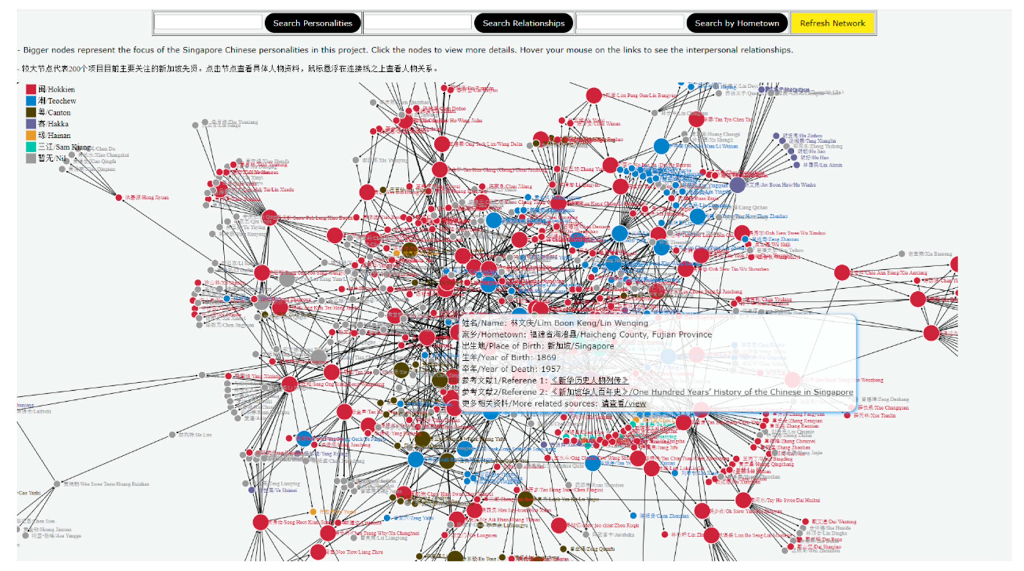
1. Introduction
2. Historical GIS
3. SHGIS
3.1. Data Preparation
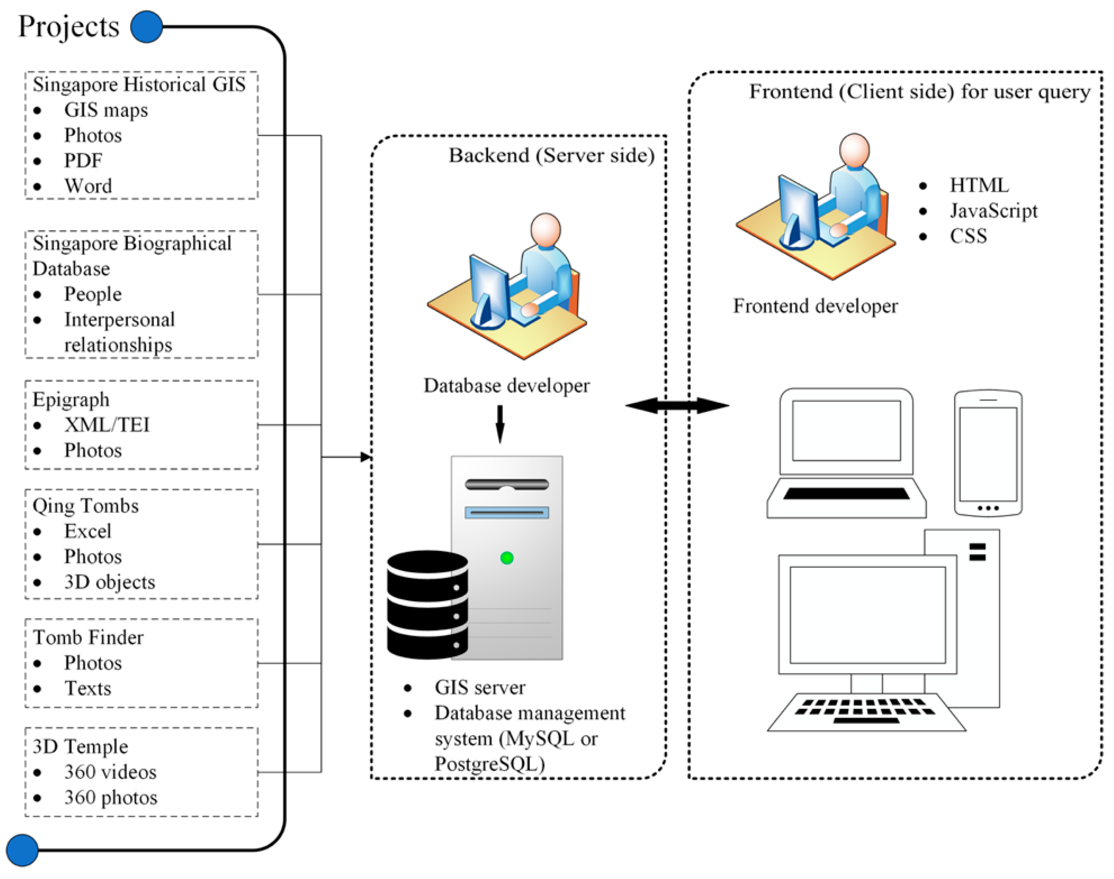
3.2. System Architecture
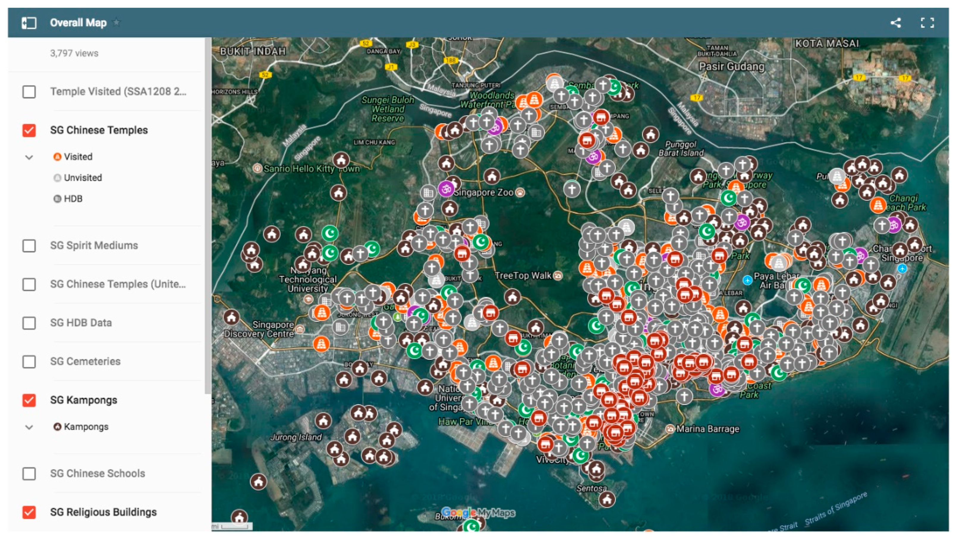
3.3. WebGIS Visualizations
3.4. Static Maps
3.5. Time-Aware Maps
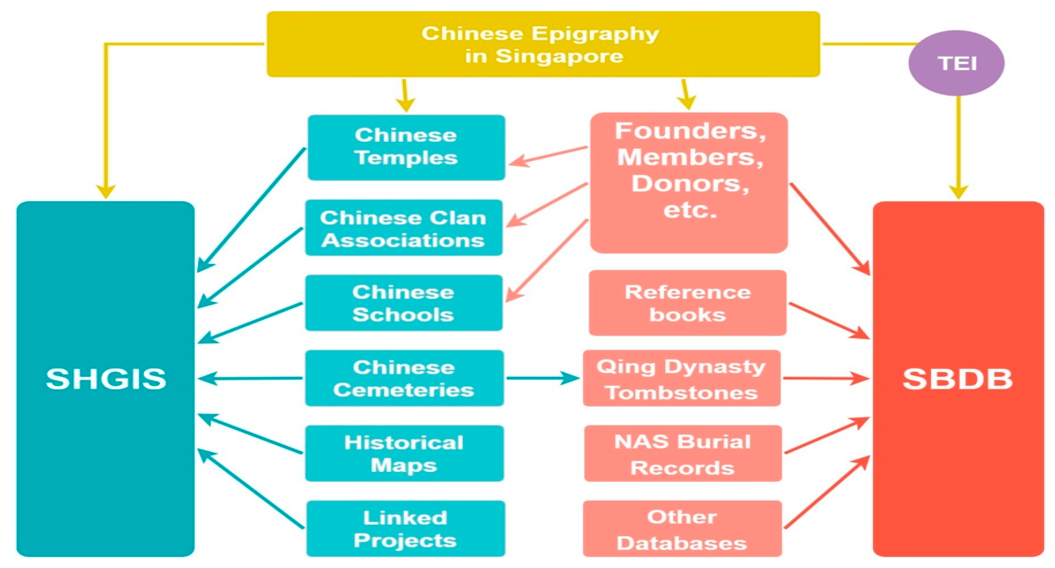
4. Combining the Singapore Biographical Database and the Singapore Historical GIS
5. Models for This Project
The main objective of the CHGIS project is to create a flexible tool, in the form of a documented database of places and administrative units, which can be used to investigate any sort of geographically specific data related to China... Users will be able to associate their own data with CHGIS records, and then use the CHGIS database to sort, query, and display their data for different historical periods and at different levels of aggregation. The CHGIS project is designed to provide a GIS platform for scholarly and scientific research.
6. Mapping Singapore from the Jackson Plan to OneMap: Contrasts with the SHGIS
7. Adding Cultural Data to the SHGIS: Linking Stone Inscriptions to Digital Maps
8. Concluding Discussion of Future Prospects: A Collaborative Digital Humanities Platform for Southeast Asia
Author Contributions
Funding
Conflicts of Interest
References
- Abhilash, P., and V. A. Vasthav. 2015. Comparison of Windows and Linux Operating Systems in Advanced Features. International Journal of Engineering Research and Applications 5: 81–83. [Google Scholar]
- Andris, Clio. 2016. Integrating social network data into GISystems. International Journal of Geographical Information Science 30: 2009–31. [Google Scholar] [CrossRef]
- Appadurai, Arjun. 1990. Disjuncture and Difference in the Global Cultural Economy. Theory, Culture and Society 7: 295–310. [Google Scholar] [CrossRef]
- Blussé, Leonard, and Menghong Chen, eds. 2003. The Archives of the Kong Koan of Batavia. Leiden: Brill. ISBN 978-9004131576. [Google Scholar]
- Bol, Peter. 2016. Mapping China’s History. Verge: Studies in Global Asias: Asian Empires & Imperialism 2: 70–82. [Google Scholar] [CrossRef]
- Brovelli, Maria A., Marco Minghini, Gianluca Giori, and Michele Beretta. 2012. Web Geoservices and Ancient Cadastral Maps: The Web C.A.R.T.E. Project. Transactions in GIS 16: 125–42. [Google Scholar] [CrossRef]
- Casanova, José. 2019. Global Religious and Secular Dynamics: The Modern System of Classification. Leiden: Brill. ISBN 978-90-04-41198-2. [Google Scholar]
- Chen, Ching-ho, and Yeok Seo Tan. 1970. Singaporean Chinese Epigraphy. Hong Kong: CUHK Press. [Google Scholar]
- Chloupek, Brett. R. 2018. A GIS approach to cultural and historical toponymic research in Nebraska. Journal of Cultural Geography 35: 23–43. [Google Scholar] [CrossRef]
- Cunningham, Niall. 2014. Troubled geographies: A historical GIS of religion, society, and conflict in Ireland since the Great Famine. In Towards Spatial Humanities: Historical GIS and Spatial History. Edited by Ian Gregory and Alistair Geddes. Bloomington: Indiana University Press, pp. 62–88. ISBN 978-0253011862. [Google Scholar]
- Dean, Kenneth. 2010. The return visits of overseas Chinese to ancestral villages in Putian, Fujian. In Faiths on Display: Tourism and Religion in Contemporary China. Edited by Tim Oakes and Donald Sutton. London: Routledge, pp. 254–75. ISBN 97801-4422-0506-2; 978-1-4422-0509-6. (electronic). [Google Scholar]
- Dean, Kenneth. 2011. Ritual Revolutions: Temple and Trust Networks Linking Putian to Southeast Asia. In Encounters: An International Journal for the Study of Culture and Society. Special Issue. Edited by Peter van der Veer. Abu Dhabi and Dubai: Zayed University, pp. 17–42. [Google Scholar] [CrossRef]
- Dean, Kenneth. 2015. Parallel Universe: The Chinese Temples of Singapore. In Handbook of Asian Cities and Religion. Edited by Peter van der Veer. Berkeley: U. C. California Press, pp. 257–89. [Google Scholar]
- Dean, Kenneth. 2016. Conditions of Mastery: The syncretic religious field of Singapore and the rise of Hokkien Taoist Master Tan Kok Hian. Cahiers d’Extreme-Asie 25: 219–44. [Google Scholar] [CrossRef]
- Dean, Kenneth. 2018. Renewed flows of ritual knowledge and ritual affect within transnational networks: A case study of three ritual-events of the Xinghua (Henghwa) communities in Singapore. In Asian Migrants and Religious Experiences. Edited by Brenda Yeoh and Bernardo Brown. Amsterdam: Amsterdam University Press, pp. 71–100. [Google Scholar]
- Dean, Kenneth. 2019a. Whose Orders? The Chinese popular god temple networks in Southeast Asia and the rise of Chinese Buddhist Mahayana monasteries. In Buddhist and Islamic Orders in Southeast Asia: Comparative Perspectives. Edited by Anne Blackburn and Michael Feener. Honolulu: University of Hawaii Press, pp. 99–124. ISBN 9780824872113. [Google Scholar]
- Dean, Kenneth. 2019b. Spirit Mediums and Secular/Religious Divides in China and Singapore. In The Secular in South, East, and Southeast Asia. Edited by Kenneth Dean and Peter van der Veer. New York: Palgrave Macmillan, pp. 53–84. ISBN 978-3-319-89369-3. [Google Scholar]
- Dean, Kenneth, and Guan Thye Hue. 2017. Chinese Epigraphy in Singapore: 1819–1911. Singapore: NUS Press. [Google Scholar]
- Dean, Kenneth, and Guan Thye Hue. Forthcoming. Chinese Epigraphy in Singapore: 1911–2019. Singapore: NUS Press.
- Dean, Kenneth, and Zhenman Zheng. 1993. Group initiation and exorcistic dance in the Xinghua Region. Min-su ch’u-i (Chinese Ritual, Theater and Folklore) 85: 105–95. [Google Scholar]
- Dean, Kenneth, and Zhenman Zheng. 1995. Epigraphical Materials on the History of Religion in Fujian: The Xinghua Region. Fuzhou: Fujian Peoples’ Publishing House Press. [Google Scholar]
- Dean, Kenneth, and Zhenman Zheng. 2004. Epigraphical Materials on the History of Religion in Fujian: The Quanzhou Region. 3 vols, Fuzhou: Fujian Peoples’ Publishing House. [Google Scholar]
- Dean, Kenneth, and Zhenman Zheng. 2010. Ritual Alliances of the Putian Plains. 2 vols, Leiden: Brill, ISBN 978-9004176027 (v.1), 978-9004176010 (v.2). [Google Scholar]
- Dean, Kenneth, and Zhenman Zheng. 2019a. The Rise of a ‘Temple-Centric’ Society in Putian in the Song and Later Transformations of the Ritual Sphere. Min-su ch’u-I (Journal of Chinese Ritual, Theatre and Folklore) 205: 103–59. [Google Scholar] [CrossRef]
- Dean, Kenneth, and Zhenman Zheng. 2019b. Epigraphical Materials on the History of Religion in Fujian: Zhangzhou Region. 4 vols, Fuzhou: Fujian People’s Publishing House. [Google Scholar]
- Dean, Kenneth, Guan Thye Hue, and Yiran Xue. forthcoming. Qing Tombs of Singapore. Singapore: NUS Press.
- Ducruet, César, and Laurent Beauguitte. 2014. Spatial science and network science: Review and outcomes of a complex relationship. Networks and Spatial Economics 14: 297–316. [Google Scholar] [CrossRef]
- Eisner, Wendy R., Jessica Jelacic, Chris J. Cuomo, Changjoo Kim, Kenneth M. Hinkel, and Dorin Del Alba. 2012. Producing an Indigenous Knowledge Web GIS for Arctic Alaska Communities: Challenges, Successes, and Lessons Learned. Transactions in GIS 16: 17–37. [Google Scholar] [CrossRef]
- Franke, Wolfgang, ed. 1998. with editorial assistance from Liu Lifang, and assistance from Hu Junyin and Zhang Liqing. Taiguo Hua wen ming ke hui bian (Chinese epigraphic Materials in Thailand). Taibei Shi: Xinwenfeng chuban gongsi. ISBN 9571717614. [Google Scholar]
- Franke, Wolfgang, and Tieh Fan Chen, eds. 1982–1985. Chinese Epigraphic Materials in Malaysia. 2 vols, Kuala Lumpur: University of Malaysia Press. [Google Scholar]
- Franke, Wolfgang, Claudine Salmon, Anthony Siu, Hu Luyun, and Teo Lee Kheng. 1988–1997. Chinese Epigraphic Materials in Indonesia. 3 parts in 4 vols. Singapore: Nanyang Xuehui. ISBN 997193616X. [Google Scholar]
- Gregory, Ian N., and Alistair Geddes. 2014. From historical GIS to spatial humanities: Deepening scholarship and broadening technology. In Towards Spatial Humanities: Historical GIS and Spatial History. Edited by Ian Gregory and Alisatair Geddes. Bloomington: Indiana University Press, pp. xi–xix. ISBN 978-0253011862. [Google Scholar]
- Gregory, Ian. N., and Richard G. Healey. 2007. Historical GIS: Structuring, mapping and analysing geographies of the past. Progress in Human Geography 31: 638–53. [Google Scholar] [CrossRef]
- Gu, Yanqiu. 2014. Important Tombs, Epigraphs, Documents of Kwong Tong Cemetery Kuala Lumpur. Kuala Lumpur: Centre for Malaysian Chinese Studies and The Association of Kwong Tong Cemetery Management Kuala Lumpur. ISBN 978-9833908295. (In Chinese) [Google Scholar]
- Hagge, Patrick D. 2016. Toward spatial humanities: Historical GIS & spatial history. Social & Cultural Geography 17: 598–99. [Google Scholar] [CrossRef]
- Hodder, Brian. W. 1953. Racial grouping in Singapore. Malayan Journal of Tropical Geography 1: 25–36. [Google Scholar]
- Huang, Jianli. 2010. Conceptualizing Chinese Migration and Chinese Overseas: The Contribution of Wang Gungwu. Journal of Chinese Overseas 6: 1–21. [Google Scholar] [CrossRef]
- Hue, Guan Thye. 2011. The Evolution of the Singapore United Temple: The Transformation of Chinese Temples in the Chinese Southern Diaspora. Chinese Southern Diaspora Studies 5: 157–74. [Google Scholar]
- Hue, Guan Thye, Kenneth Dean, Yingwei Yan, and Yiran Xue. 2019. Research on the Chinese cemeteries of Singapore: A case study of the founding of the Hokkien charitable Pavilion of the Eternal Mountain cemetery and its management model. Journal of the South Seas Society 73: 41–64. [Google Scholar]
- Jao, Tsung-i. 1969. A Chronological narrative of Singapore and Malaysia based on Chinese stone inscriptions. Journal of the Chinese University of Singapore 10: 1–51. (In Chinese). [Google Scholar]
- Kallaher, Amelia, and Alyson Gamble. 2017. GIS and the humanities: Presenting a path to digital scholarship with the Story Map app. College & Undergraduate Libraries 24: 559–73. [Google Scholar]
- Kong, Lily. 1990. Geography and religion: Trends and prospects. Progress in Human Geography 14: 355–71. [Google Scholar] [CrossRef]
- Kong, Lily. 1993a. Negotiating conceptions of ‘sacred space’: A case study of religious buildings in Singapore. Transactions of the Institute of British Geographers 18: 342–58. [Google Scholar] [CrossRef]
- Kong, Lily. 1993b. Ideological hegemony and the political symbolism of religious buildings in Singapore. Environment and Planning D: Society and Space 11: 23–45. [Google Scholar] [CrossRef]
- Kong, Lily. 1999. Cemeteries and columbaria, memorials and mausoleums: Narrative and interpretation in the study of deathscapes in geography. Australian Geographical Studies 37: 1–10. [Google Scholar] [CrossRef]
- Kong, Lily. 2001. Mapping ‘new’ geographies of religion: Politics and poetics in modernity. Progress in Human Geography 25: 211–33. [Google Scholar] [CrossRef]
- Kong, Lily. 2002. In search of permanent homes: Singapore’s house churches and the politics of space. Urban Studies 39: 1573–86. [Google Scholar] [CrossRef]
- Kong, Lily. 2005. Religious processions: Urban politics and poetics. Temenos-Nordic Journal of Comparative Religion 41: 225–49. [Google Scholar] [CrossRef]
- Kong, Lily. 2010. Global shifts, theoretical shifts: Changing geographies of religion. Progress in Human Geography 34: 755–76. [Google Scholar] [CrossRef]
- Kong, Lily, and Brenda S. A. Yeoh. 1997. The construction of national identity through the production of ritual and spectacle: An analysis of National Day parades in Singapore. Political Geography 16: 213–39. [Google Scholar] [CrossRef]
- Kuhn, Philip. 2008. Chinese Amongst Others: Emigration in Modern Times. Singapore: NUS Press. ISBN 978-9971-69-414-2. [Google Scholar]
- Kwee, Hui Kian. 2007. Pockets of Empire: Integrating the Studies of Social Organizations in Southeast China and Southeast Asia. Comparative Studies of South Asia, Africa and the Middle East 27: 616–32. [Google Scholar] [CrossRef]
- Liew, Kam Ba. 2014. Zoujin Basheng shenmiao—Basheng gangkou Bandamalan xincun miaoyu wenhua chutan (Entering the God Temples of Klang: Preliminary Discussion of the Temple Culture of the Pandamaran New Village. Kuala Lumpur: New Era College. ISBN 9789833527571. [Google Scholar]
- Mah, Osten Bang Ping, Yingwei Yan, Jonathan Song Yi Tan, Yi-Xuan Tan, Geralyn Qi Ying Tay, Da Jian Chiam, Yi-Chen Wang, Kenneth Dean, and Chen-Chieh Feng. 2019. Generating a virtual tour for the preservation of the (in) tangible cultural heritage of Tampines Chinese Temple in Singapore. Journal of Cultural Heritage 39: 202–21. [Google Scholar] [CrossRef]
- Mok, Ly Yng. 2015. Mapping Singapore, 1819–2014. In Visualizing Space: Maps of Singapore and the Region. Singapore: National Library Board, pp. 86–117. ISBN 9789814634083. [Google Scholar]
- Oswin, Natalie, and Brenda S. A. Yeoh. 2010. Introduction: Mobile City Singapore. Mobilities 5: 167–75. [Google Scholar] [CrossRef]
- Presner, Todd, and David Shepard. 2016. Mapping the Geospatial Turn. In A New Companion to Digital Humanities. Edited by Susan Schreibman, Ray Siemens and John Unsworth. Chichester: John Wiley & Sons, Ltd., pp. 201–12. ISBN 9781118680599. [Google Scholar]
- Reid, Anthony. 1988. Southeast Asia in the Age of Commerce, 1450-1680. Vol. I: The Lands below the Winds. New Haven: Yale University Press. ISBN 978-0300047509. [Google Scholar]
- Reid, Anthony. 1993. Southeast Asia in the Age of Commerce, 1450-1680. Vol. II: Expansion and Crisis. New Haven: Yale University Press. ISBN 978-0300054122. [Google Scholar]
- Salmon, Claudine. 2007. Cultural Links between Insulindian Chinese and Fujian as Reflected in Two Late 17th-Century Epigraphs. Archipel 73: 167–94. [Google Scholar] [CrossRef]
- Schreibman, Susan, Ray Siemens, and John Unsworth. 2004. The Digital Humanities and Humanities Computing: An Introduction. Oxford: Blackwell Publishing. [Google Scholar] [CrossRef]
- Skinner, George William. 1957. Chinese Society in Thailand: An Analytical History. Ithaca: Cornell University Press. ISBN 978-1597406062. [Google Scholar]
- Skinner, George William. 1958. Leadership and Power in the Chinese Community of Thailand. Ithaca: Cornell University Press, (Monographs of the Association for Asian Studies, III). ISBN 978-0801403897. [Google Scholar]
- Skinner, G. William. 1996. Creolized Chinese societies in Southeast Asia. In Sojourners and Settlers: Histories of Southeast Asia and the Chinese: In Honour of Jennifer Cushman. Edited by Anthony Reid. Sydney: Allen and Unwin, pp. 50–93. ISBN 1863739904. [Google Scholar]
- Stanev, Kaloyan. 2013. A Historical GIS Approach to Studying the Evolution of the Railway and Urban Networks: The Balkans, 1870–2001. Historical Methods: A Journal of Quantitative and Interdisciplinary History 46: 192–201. [Google Scholar] [CrossRef]
- Streiter, Oliver. 2017. On the late Work of Wolfgang Franke and its Role in the Study of Chinese Epigraphies. Paper presented at the Conference on Taiwan Tombs, Academia Sincia, Taiwan, March 17–18. [Google Scholar]
- Tan, Chee Beng. 2015. After Migration and Religious Affiliation: Religions, Chinese Identities, and Transnational Networks. Singapore: World Scientific Publishing Company. ISBN 978-9814583909. [Google Scholar]
- Tan, Ai Boay, and Toeng Chuan Toh. 2017. Trails of the Nanyang Chinese: History and Legends of the Cave Temples of Ipoh, Malaysia. Beijing: CASS Press. ISBN 978-7520306256. (In Chinese) [Google Scholar]
- Tilly, Charles. 1990. Coercion, Capital, and European States, AD 990–1990. Cambridge: Blackwell. [Google Scholar]
- Wang, Gungwu. 2003. Don’t Leave Home: Migration and the Chinese. Singapore: Eastern Universities Press. ISBN 978-9812102423. [Google Scholar]
- Wong, Wun Bin. 2013. A Collection of Tombstone Inscriptions of Bukit China, Malacca (1614–1820). Kuala Lumpur: Center for Malaysian Studies. ISBN 978-9833908264. (In Chinese) [Google Scholar]
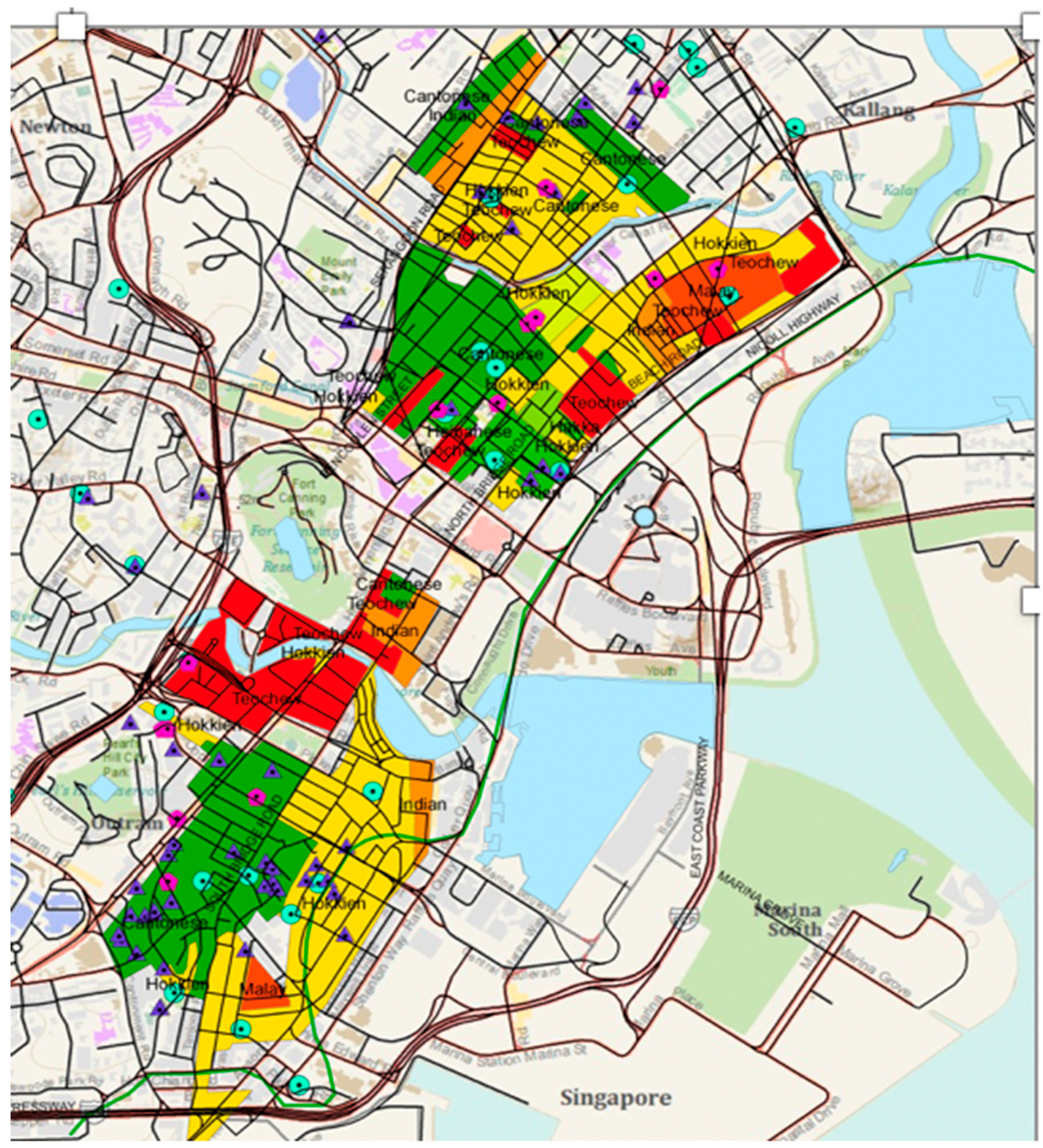
- Yamashita, Kyomi. 1986. The Residential Segregation of Chinese Dialect Groups in Singapore: With Focus on the Period before ca. 1970. Geographical Review of Japan 59: 83–102. [Google Scholar] [CrossRef]
- Yeoh, Brenda S. A. 1996. Contesting Space in Colonial Singapore: Power Relations in the Urban Built Environment. New York: Oxford University Press, Reprint by NUS Press in 2003. ISBN 978-9971692681. [Google Scholar]
| 1 | There are a variety of geocoding services such as Google’s geocoding API (https://developers.google.com/maps/documentation/geocoding/start) and Esri’s geocoding with ArcGIS (https://developers.arcgis.com/features/geocoding/). OneMap is based on Singapore’s postal code in which each building has a unique postal code. |
| 2 | Data drawn from lists of spirit medium altars published by the Taoist Association of Singapore. We are not aware of any increased vulnerability of the owners of these altars from publicly listing their addresses, or from our including these points on the SHGIS. |
| 3 | The integration of GIS and the web makes data sharing much easier and allows for the incorporation of multimedia data (e.g., images, documents, and video). The selection between opensource GIS and commercial GIS affects the specific process of WebGIS development and its outcomes. We greatly appreciate the value of free and opensource options. However, as a small team of humanists working on the exploratory phase of the SHGIS, our project lacked a team of developers who are not only highly technically savvy and independent but also familiar with the context of Singaporean Chinese culture. Since documentation and support for opensource solutions are often lacking compared with commercial solutions, a complete development based on the former can be more expensive than the latter. Therefore, this project chose to leverage on commercial GIS solutions instead of opensource solutions. Nevertheless, we look forward to the continued improvement of opensource software such as QGIS, as this could help with issues of long-term preservation. We would like to note that the historical maps, as well as the feature layers (i.e., the point, polygon, and polyline layers) in our platform are enabled with OGC (Open Geospatial Consortium) capabilities. Experienced users can download this data. We are continuously expanding and correcting the data, and plan to announce a SHGIS 2.0 in January 2021. |
| 4 | We believe the parallel publication of open standards-based services (OGC) in addition to ESRI’s proprietary services increases the potential impact and reusability of the published data. |
| 5 | We are aware that there are limits of scalability and that the increase of data and the number of nodes may impact the display speed and legibility of data visualization of social networks on our web interface. We have discussed maintaining a user-friendly public web interface for the visualization of the social networks of famous Singaporeans, along with a greatly expanded EXCEL biographical database that users could download and explore with desktop SNA software such as GEPHI. |
| 6 | By contrast, the SBDB website currently displays 200 individuals in their connections with 600 others. Data was drawn from biographical dictionaries, and NLB (National Library Board) and NUS Chinese library data sets, but issues of verification of data persist. We have developed an expanded EXCEL database of 4000 individuals that can be downloaded. We are working on the best ways to integrate data from other sources such as inscriptions, burial records, genealogies, and tomb inscriptions. Incorporating this data would lead to a database of over 200,000 individuals. |
| 7 | OneMap’s services include OGC (Open Geospatial Consortium data, proprietary GIS services (such as services published using the ESRI ArcGIS APIs) as well as custom services. See https://www.onemap.sg/home/. |
| 8 | Various digital databases of epigraphy exist in other fields, especially Classics. The international federation, Electronic Archive of Greek and Latin Epigraphy (EAGLE, http://www.eagle-eagle.it), comprises several large collections of epigraphic materials. |


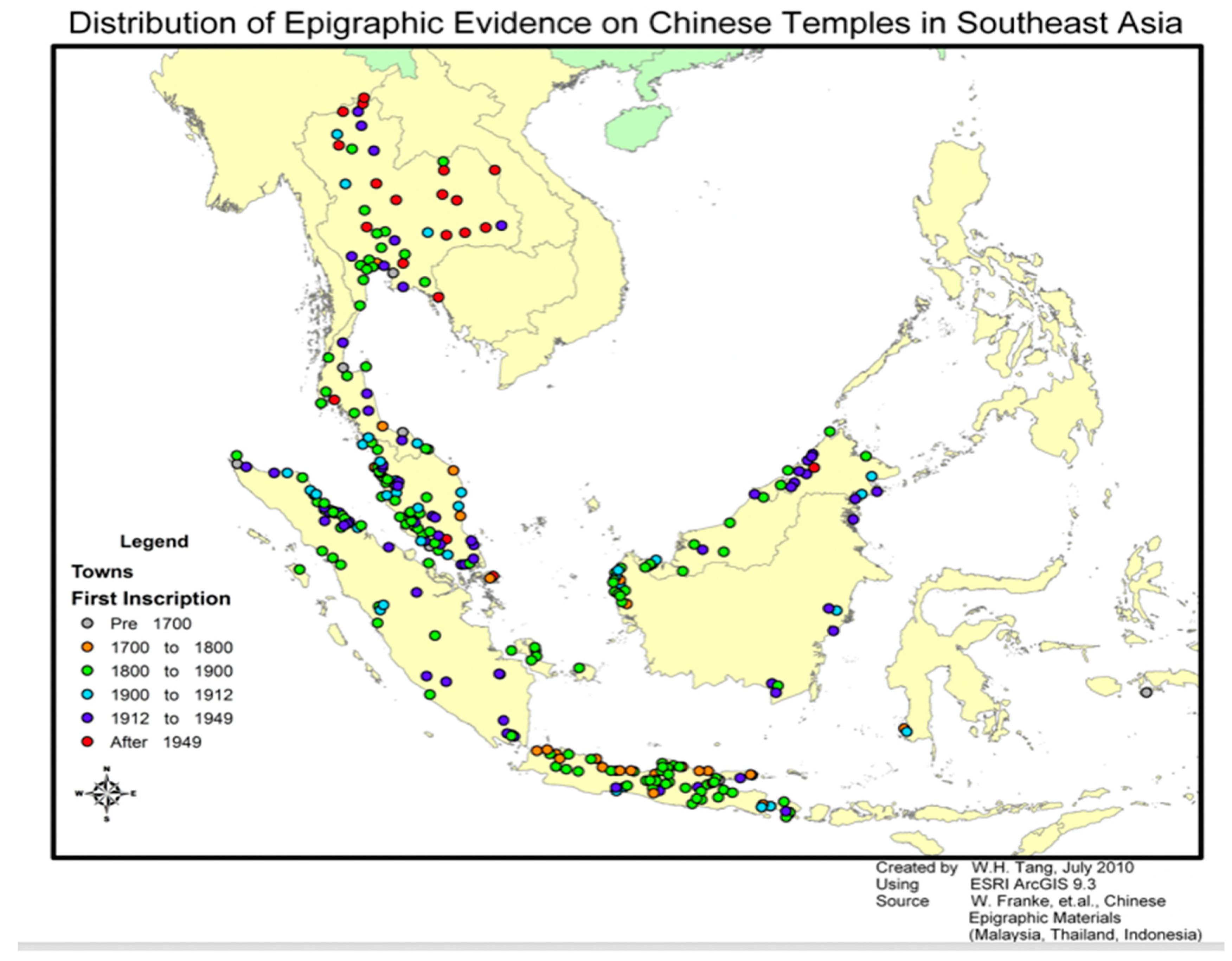
| Indonesia | Malaysia | Thailand | Total | |||||
|---|---|---|---|---|---|---|---|---|
| Sites | Inscriptions | Sites | Inscriptions | Sites | Inscriptions | Sites | Inscriptions | |
| Temples | 237 | 1285 | 167 | 688 | 173 | 556 | 577 | 2529 |
| Cemeteries | 180 | 1207 | 99 | 383 | 70 | 350 | 349 | 1940 |
| Associations | 12 | 54 | 85 | 151 | 26 | 82 | 123 | 287 |
| Ancestral Halls | 18 | 114 | 26 | 89 | 3 | 7 | 47 | 210 |
| Miscellaneous | 9 | 15 | 20 | 38 | 18 | 30 | 47 | 83 |
| Total | 456 | 2675 | 397 | 1349 | 290 | 1025 | 1143 | 5049 |
| Temples, Shrines, Pavilions | Huiguan Native-Place Associations | Clan Halls | Schools | Hospitals | Other | Total |
|---|---|---|---|---|---|---|
| 42 | 13 | 7 | 1 | 2 | 9 | 74 |
| Stelae | Stelae | Plaques | Plaques | Couplets | Couplets | Other | Other | Total |
|---|---|---|---|---|---|---|---|---|
| 1819–1911 | 1911–2012 | 1819–1911 | 1911–2012 | 1819–1911 | 1911–2012 | 1819–1911 | 1911–2012 | |
| 198 | 189 | 217 | 236 | 120 | 144 | 114 | 47 | 1265 |
| Stelae | Plaques | Couplets | Other | Total |
|---|---|---|---|---|
| 387 | 453 | 264 | 161 | 1265 |
| Pre-1911 Cultural Artifacts | 1911–2012 Cultural Artifacts | Total |
|---|---|---|
| 649 | 616 | 1265 |
© 2020 by the authors. Licensee MDPI, Basel, Switzerland. This article is an open access article distributed under the terms and conditions of the Creative Commons Attribution (CC BY) license (http://creativecommons.org/licenses/by/4.0/).
Share and Cite
Yan, Y.; Dean, K.; Feng, C.-C.; Hue, G.T.; Koh, K.-h.; Kong, L.; Ong, C.W.; Tay, A.; Wang, Y.-c.; Xue, Y. Chinese Temple Networks in Southeast Asia: A WebGIS Digital Humanities Platform for the Collaborative Study of the Chinese Diaspora in Southeast Asia. Religions 2020, 11, 334. https://doi.org/10.3390/rel11070334
Yan Y, Dean K, Feng C-C, Hue GT, Koh K-h, Kong L, Ong CW, Tay A, Wang Y-c, Xue Y. Chinese Temple Networks in Southeast Asia: A WebGIS Digital Humanities Platform for the Collaborative Study of the Chinese Diaspora in Southeast Asia. Religions. 2020; 11(7):334. https://doi.org/10.3390/rel11070334
Chicago/Turabian StyleYan, Yingwei, Kenneth Dean, Chen-Chieh Feng, Guan Thye Hue, Khee-heong Koh, Lily Kong, Chang Woei Ong, Arthur Tay, Yi-chen Wang, and Yiran Xue. 2020. "Chinese Temple Networks in Southeast Asia: A WebGIS Digital Humanities Platform for the Collaborative Study of the Chinese Diaspora in Southeast Asia" Religions 11, no. 7: 334. https://doi.org/10.3390/rel11070334
APA StyleYan, Y., Dean, K., Feng, C.-C., Hue, G. T., Koh, K.-h., Kong, L., Ong, C. W., Tay, A., Wang, Y.-c., & Xue, Y. (2020). Chinese Temple Networks in Southeast Asia: A WebGIS Digital Humanities Platform for the Collaborative Study of the Chinese Diaspora in Southeast Asia. Religions, 11(7), 334. https://doi.org/10.3390/rel11070334