Long-Term Shoreline Evolution Using DSAS Technique: A Case Study of Quang Nam Province, Vietnam
Abstract
:1. Introduction
2. Case Study and Data Collection
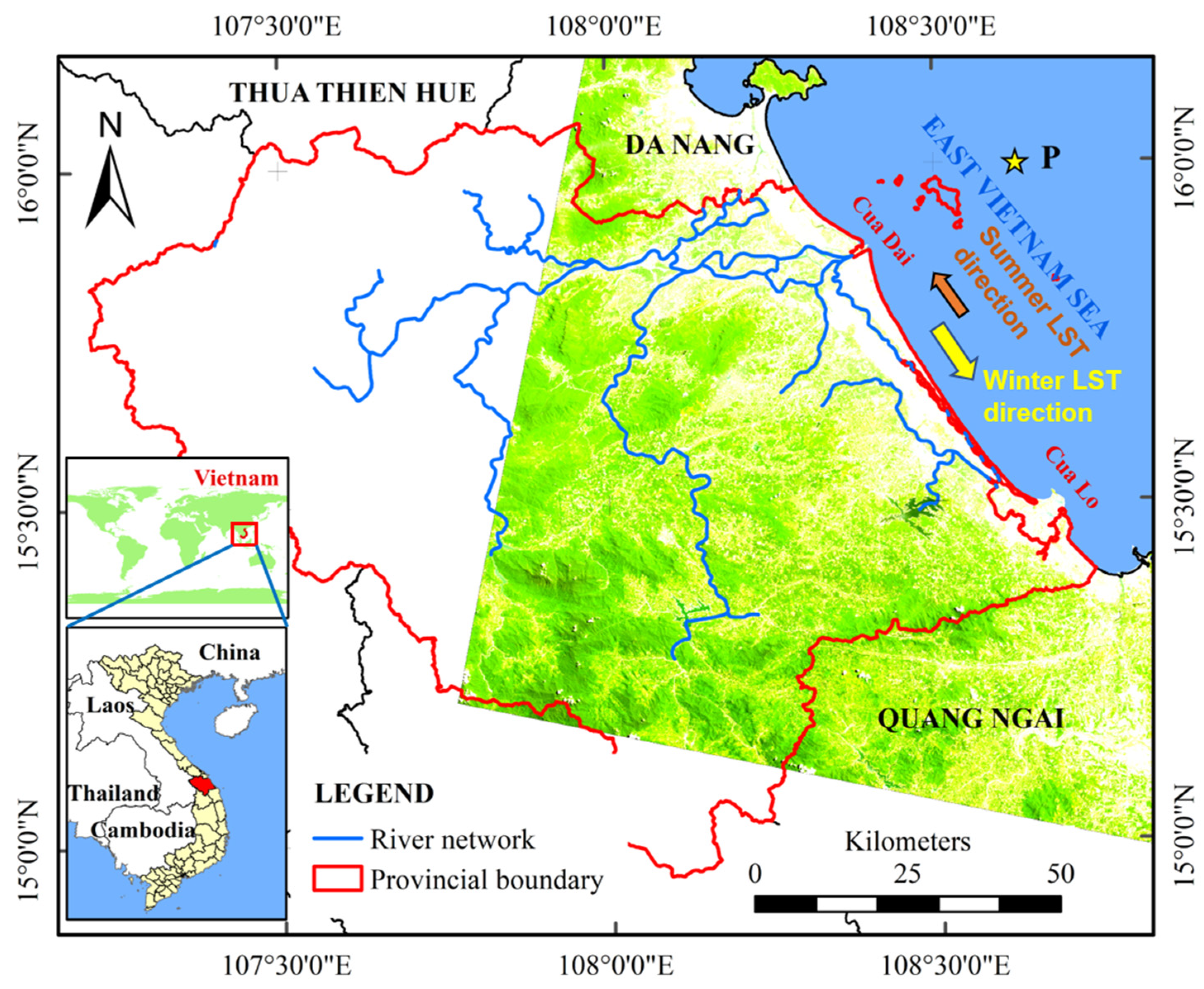
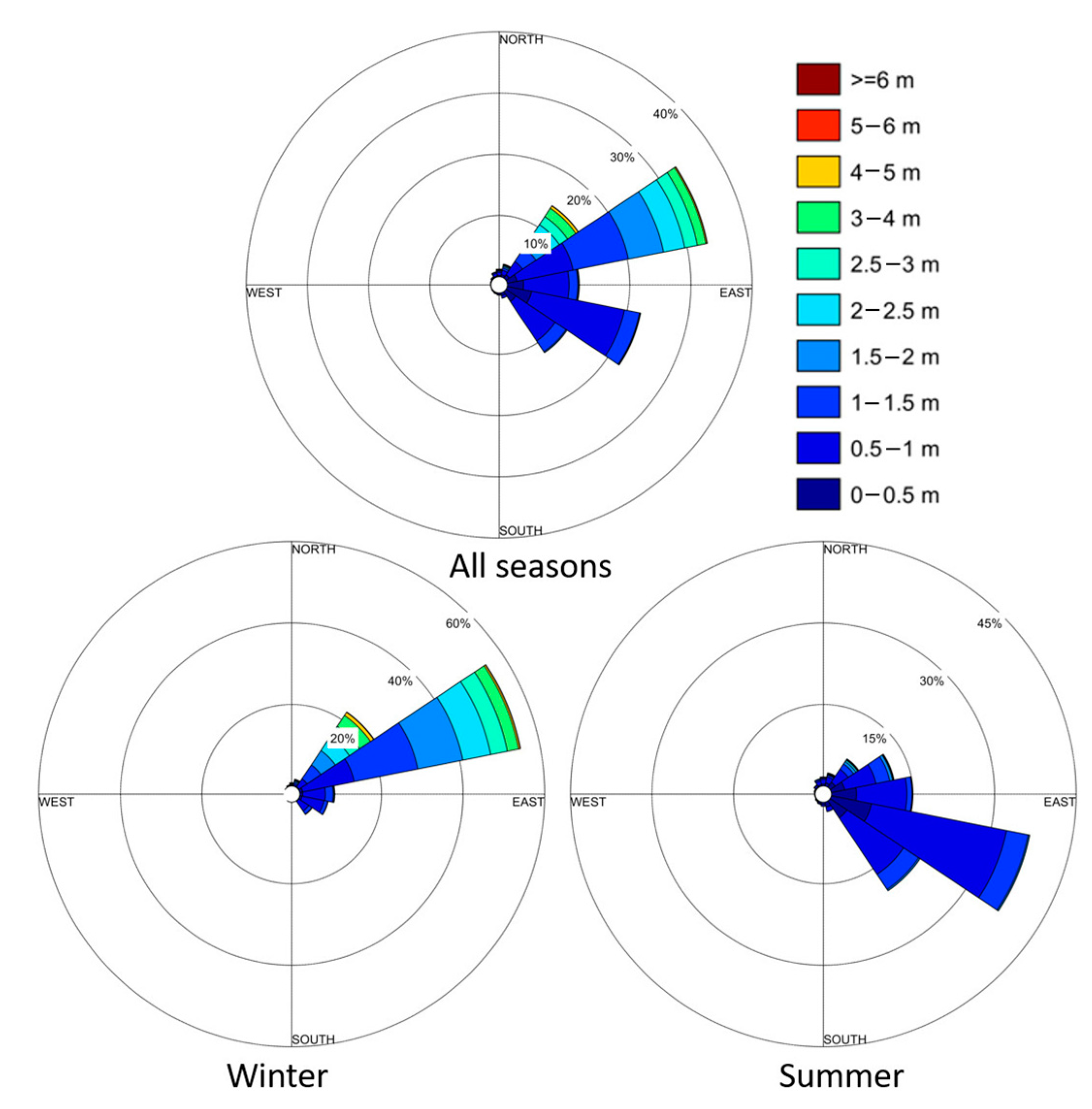
2.1. Case Study
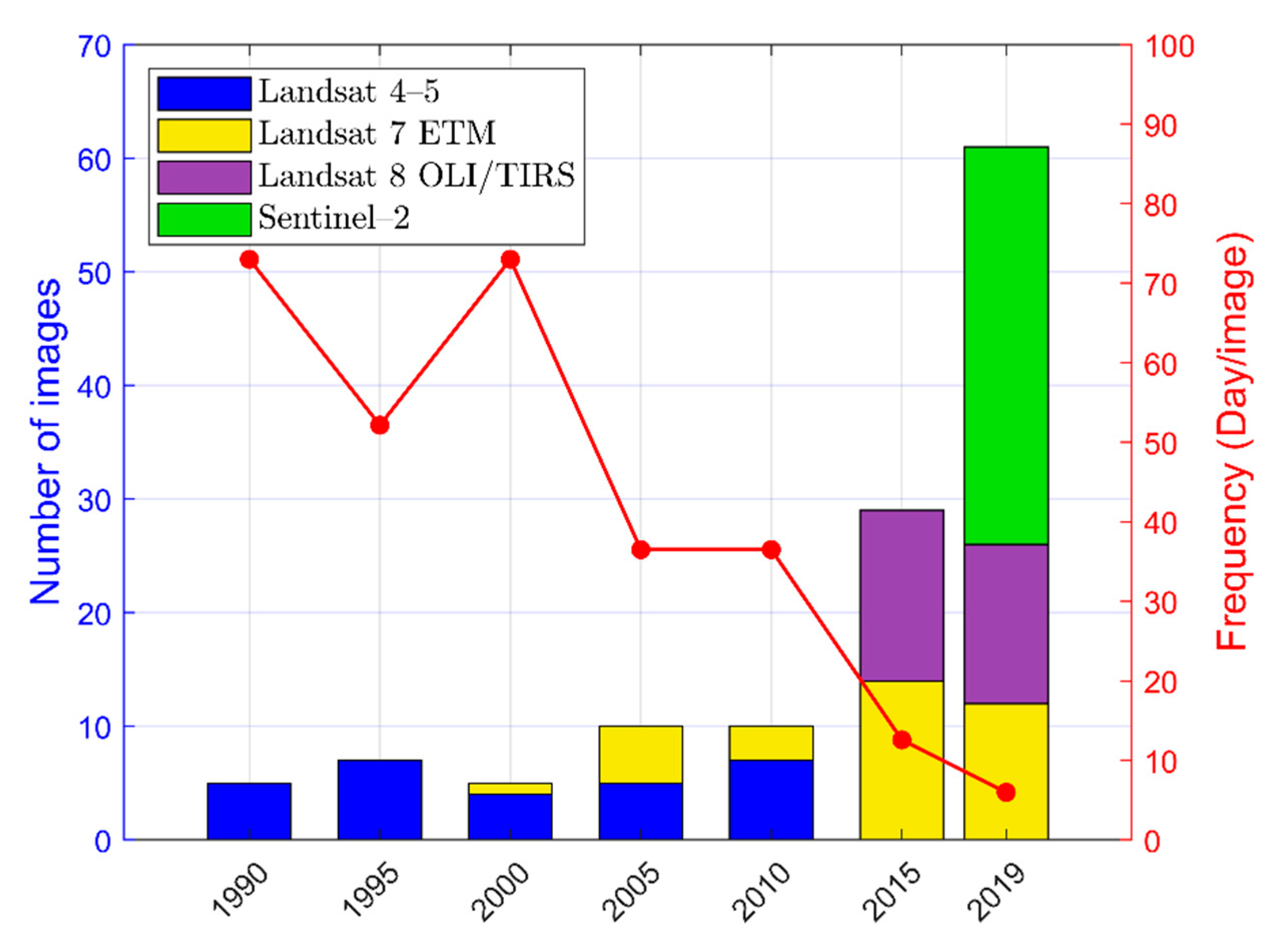
2.2. Data Collection
3. Methods
3.1. Computation and Threshold of the mNDWI
3.2. Annual Coastline Analysis
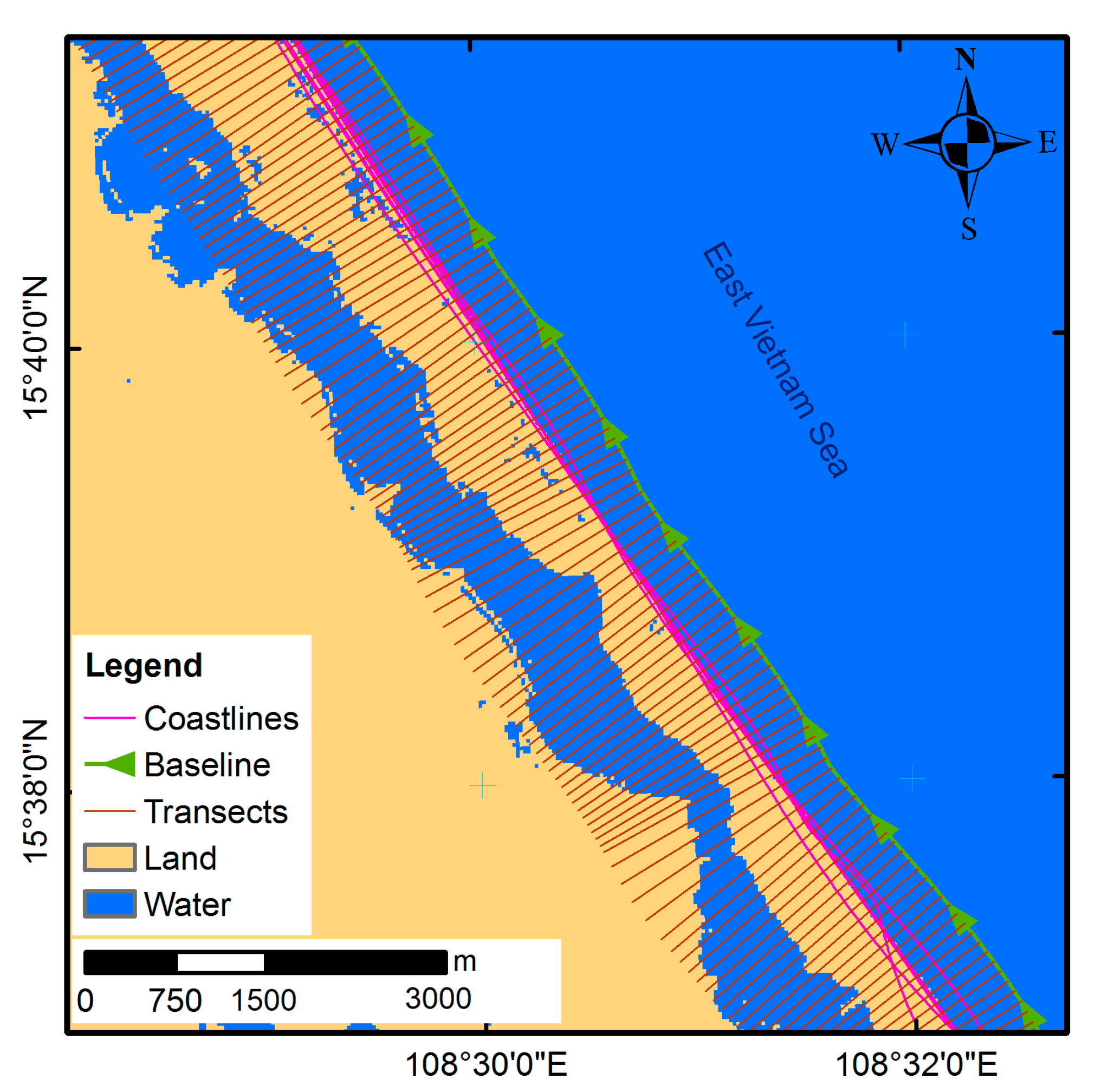
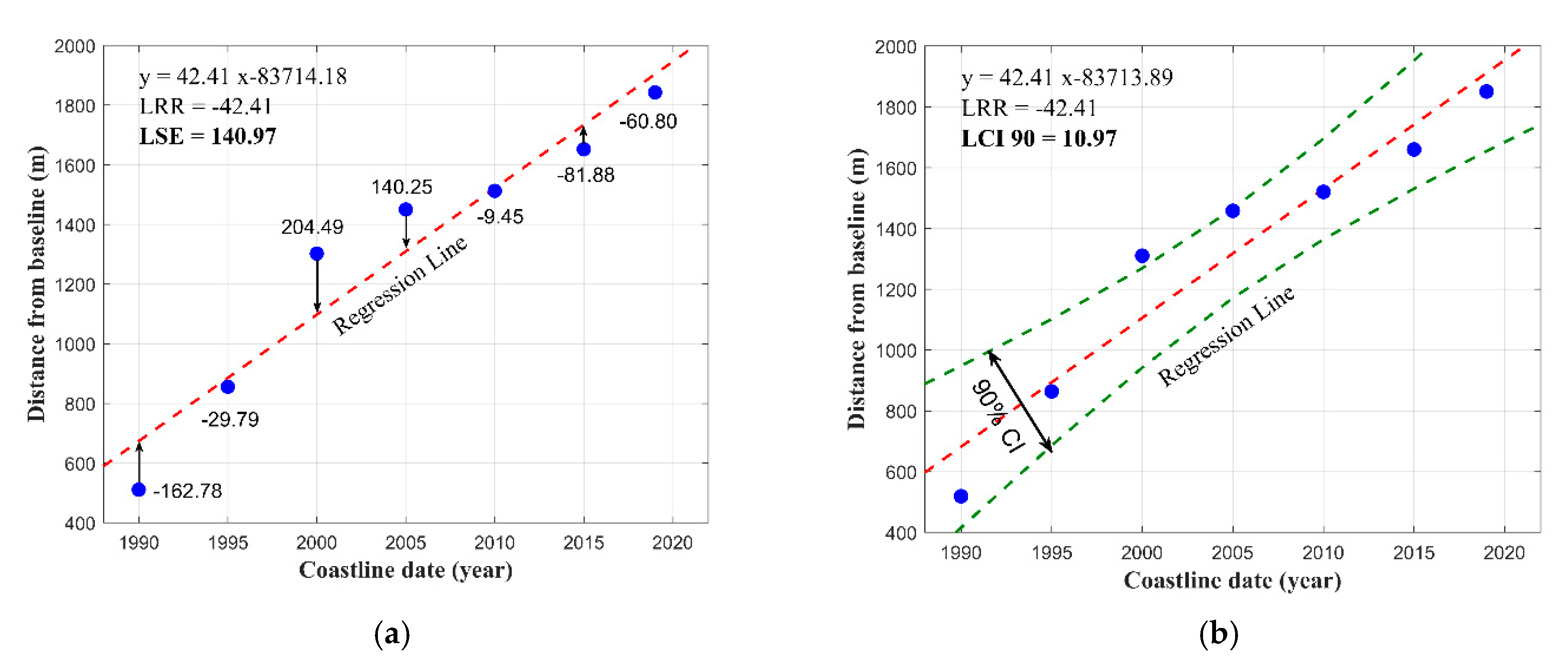
3.3. Coastline Change Analysis by Applying DSAS
4. Results and Discussion
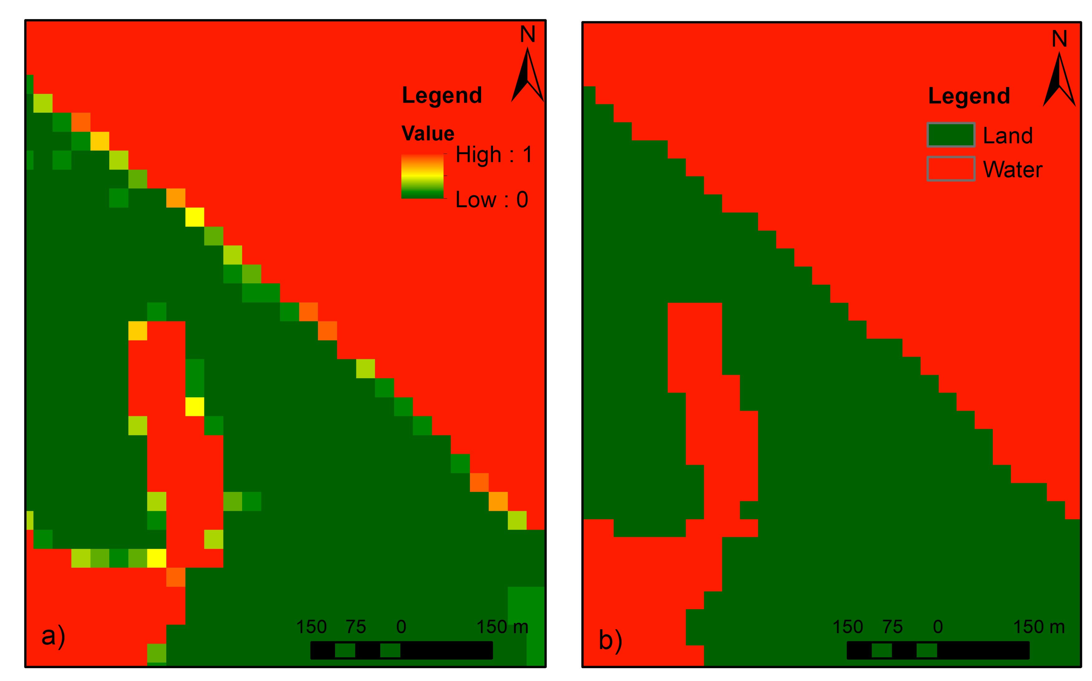
4.1. Analysis of Annual Land–Water Classification Map
4.2. Long-Term Shoreline Evolution
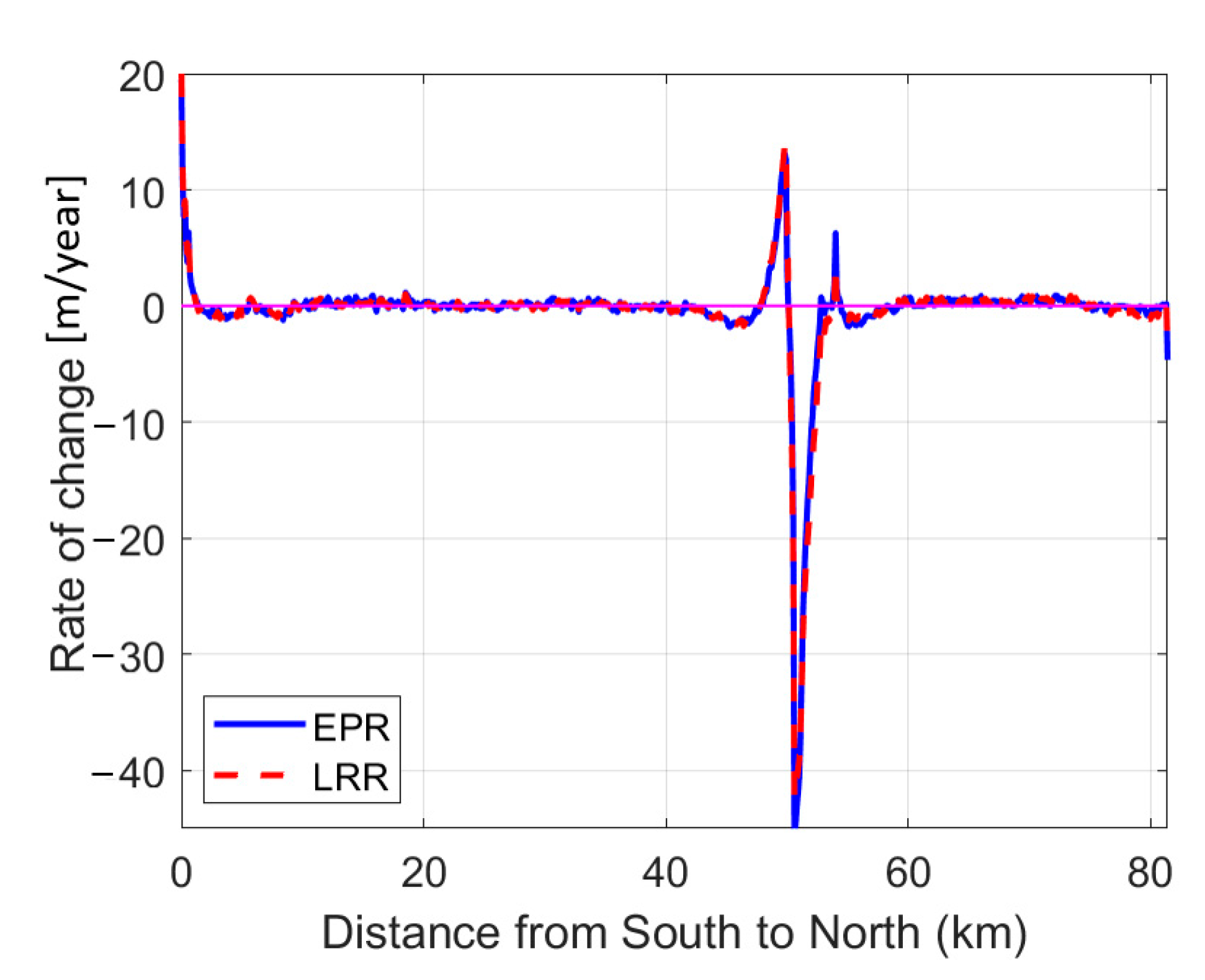
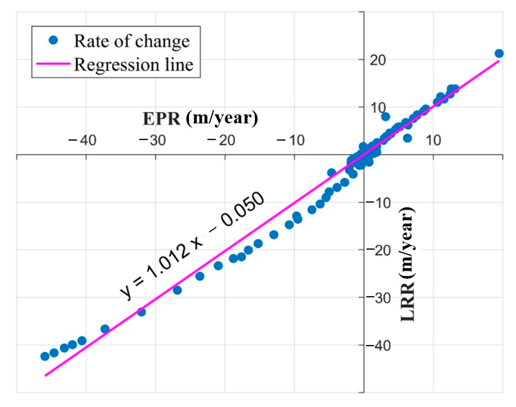
4.3. Spatial Pattern Variation Analysis of Coastline Change
4.4. Temporal Pattern Variation Analysis of Coastline Change
5. Conclusions
Author Contributions
Funding
Institutional Review Board Statement
Informed Consent Statement
Data Availability Statement
Acknowledgments
Conflicts of Interest
References
- Cai, F.; Su, X.; Liu, J.; Li, B.; Lei, G. Coastal erosion in China under the condition of global climate change and measures for its prevention. Prog. Nat. Sci. 2009, 19, 415–426. [Google Scholar] [CrossRef]
- Raj, N.; Gurugnanam, B.; Sudhakar, V.; Francis, P.G. Estuarine shoreline change analysis along The Ennore river mouth, south east coast of India, using digital shoreline analysis system. Geod. Geodyn. 2019, 10, 205–212. [Google Scholar]
- Dereli, M.A.; Tercan, E. Assessment of Shoreline Changes using Historical Satellite Images and Geospatial Analysis along the Lake Salda in Turkey. Earth Sci. Inform. 2020, 13, 709–718. [Google Scholar] [CrossRef]
- Addo, K.A.; Jayson-Quashigah, P.N.; Kufogbe, K.S. Quantitative Analysis of Shoreline Change Using Medium Resolution Satellite Imagery in Keta, Ghana. Mar. Sci. 2011, 1, 1–9. [Google Scholar] [CrossRef] [Green Version]
- Eludoyin, O.S.; Oduore, T.; Obafemi, A.A. Spatio-Temporal Analysis of Shoreline Changes in Bonny Island, Nigeria. Ethiop. J. Environ. Stud. Manag. 2012, 5, 123–130. [Google Scholar] [CrossRef]
- Purkis, S.J.; Gardiner, R.; Johnston, M.W.; Sheppard, C.R.C. A half-century of coastline change in Diego Garcia – The largest atoll island in the Chagos. Geomorphology 2016, 261, 282–298. [Google Scholar] [CrossRef]
- Gómez-Pazo, A.; Pérez-Alberti, A.; Otero Pérez, X.L. Recent Evolution (1956–2017) of Rodas Beach on the Cíes Islands, Galicia, NW Spain. J. Mar. Sci. Eng. 2019, 7, 125. [Google Scholar] [CrossRef] [Green Version]
- Huang, C.; Chen, Y.; Zhang, S.; Wu, J. Detecting, Extracting, and Monitoring Surface Water From Space Using Optical Sensors: A Review. Rev. Geophys. 2018, 56, 333–360. [Google Scholar] [CrossRef]
- Herndon, K.; Muench, R.; Cherrington, E.; Griffin, R. An Assessment of Surface Water Detection Methods for Water Resource Management in the Nigerien Sahel. Sensors 2020, 20, 431. [Google Scholar] [CrossRef] [Green Version]
- Li, J.; Roy, D.P. A Global Analysis of Sentinel-2A, Sentinel-2B and Landsat-8 Data Revisit Intervals and Implications for Terrestrial Monitoring. Remote Sens. 2017, 9, 902. [Google Scholar] [CrossRef] [Green Version]
- Garcia Rubio, G.; Huntley, D.; Kingston, K.; Esteves, L. Shoreline Identification Using Satellite Images. In Proceedings of the Coastal Dynamics: Impacts of Human Activities on Dynamic Coastal Processes, Tokyo, Japan, 7–11 September 2009; pp. 1–10. [Google Scholar]
- Bangalore, M.; Smith, A.; Veldkamp, T. Exposure to Floods, Climate Change, and Poverty in Vietnam. Econ. Disasters Clim. Change 2019, 3, 79–99. [Google Scholar] [CrossRef] [Green Version]
- Duong, L.H.; Dong, T.M.H. East Sea-Natural Resources in Vietnam. Eur. J. Eng. Res. Sci. 2019, 4, 65–69. [Google Scholar] [CrossRef] [Green Version]
- Thanh, T.D.; Tien, P.H.; Cu, N.V.; Nam, B.V. Current status of coastal erosion in Vietnam and controlling orientation. Vietnam Coast. Eros. Conf. Proc. 2018, 5–17. [Google Scholar]
- Trung Viet, N.; Xiping, D.; Thanh Tung, T. Identification of Erosion-Accretion Causes and Regimes Along the Quang Nam Coast, Vietnam. In Proceedings of the APAC 2019; Springer: Singapore, 2020; pp. 809–814. [Google Scholar]
- Luu, C.; Von Meding, J. A flood risk assessment of Quang Nam, Vietnam using spatial multicriteria decision analysis. Water 2018, 10, 461. [Google Scholar] [CrossRef]
- Pham, H.T.; Nguyen, V.C. Forecasting the Erosion and Sedimentation in the Coastal and River Mouth Areas and Preventive Measures; Technical Report; State Level Research Project: Hanoi, Vietnam, 2005; p. 487. [Google Scholar]
- Le, D.M.; Pham, B.T.; Tran, V.B. Erosion features along Cua Dai beach, Hoi An city, Quang Nam province, Viet Nam. Collect. Mar. Res. Works 2018, 23, 21–31. [Google Scholar]
- Himmelstoss, E.A.; Henderson, R.E.; Kratzmann, M.G.; Farris, A.S. Digital Shoreline Analysis System (DSAS) Version 5.0 User Guide; Open-File Report 2018–1179; U.S. Geological Survey: Reston, VA, USA, 2018.
- Boak, E.H.; Turner, I. Shoreline Definition and Detection: A Review. J. Coast. Res. 2005, 21, 688–703. [Google Scholar] [CrossRef] [Green Version]
- McFEETERS, S.K. The use of the Normalized Difference Water Index (NDWI) in the delineation of open water features. Int. J. Remote Sens. 1996, 17, 1425–1432. [Google Scholar] [CrossRef]
- Xu, H. Modification of normalised difference water index (NDWI) to enhance open water features in remotely sensed imagery. Int. J. Remote Sens. 2006, 27, 3025–3033. [Google Scholar] [CrossRef]
- Feyisa, G.L.; Meilby, H.; Fensholt, R.; Proud, S.R. Automated Water Extraction Index: A new technique for surface water mapping using Landsat imagery. Remote Sens. Environ. 2014, 140, 23–35. [Google Scholar] [CrossRef]
- Fisher, A.; Flood, N.; Danaher, T. Comparing Landsat water index methods for automated water classification in eastern Australia. Remote Sens. Environ. 2016, 175, 167–182. [Google Scholar] [CrossRef]
- Xu, N. Detecting Coastline Change with All Available Landsat Data over 1986–2015: A Case Study for the State of Texas, USA. Atmosphere 2018, 9, 107. [Google Scholar] [CrossRef] [Green Version]
- Quang, D.N.; Linh, N.K.; Tam, H.S.; Viet, N.T. Remote sensing applications for reservoir water level monitoring, sustainable water surface management, and environmental risks in Quang Nam province, Vietnam. J. Water Clim. Change 2021. [Google Scholar] [CrossRef]
- Jackson, C.W.; Alexander, C.R.; Bush, D.M. Application of the AMBUR R package for spatio-temporal analysis of shoreline change: Jekyll Island, Georgia, USA. Comput. Geosci. 2012, 41, 199–207. [Google Scholar] [CrossRef]
- Kabir, M.A.; Salauddin, M.; Hossain, K.T.; Tanim, I.A.; Saddam, M.M.H.; Ahmad, A.U. Assessing the shoreline dynamics of Hatiya Island of Meghna estuary in Bangladesh using multiband satellite imageries and hydro-meteorological data. Reg. Stud. Mar. Sci. 2020, 35, 101167. [Google Scholar] [CrossRef]
- Oyedotun, T. Shoreline geometry: DSAS as a tool for Historical Trend Analysis. Geomorphol. Tech. 2014, 3, 1–12. [Google Scholar]
- Tran Thi, V.; Tien Thi Xuan, A.; Phan Nguyen, H.; Dahdouh-Guebas, F.; Koedam, N. Application of remote sensing and GIS for detection of long-term mangrove shoreline changes in Mui Ca Mau, Vietnam. Biogeosciences 2014, 11, 3781–3795. [Google Scholar] [CrossRef] [Green Version]
- Nassar, K.; Mahmod, W.E.; Fath, H.; Masria, A.; Nadaoka, K.; Negm, A. Shoreline change detection using DSAS technique: Case of North Sinai coast, Egypt. Mar. Georesour. Geotechnol. 2019, 37, 81–95. [Google Scholar] [CrossRef]
- Yulianto, F.; Suwarsono, S.; Maulana, T.; Khomarudin, R. The dynamics of shoreline change analysis based on the integration of remote sensing and geographic information system (GIS) techniques in Pekalongan coastal area, Central Java, Indonesia. J. Degraded Min. Lands Manag. 2019, 6, 1789–1802. [Google Scholar] [CrossRef] [Green Version]
- Nandi, S.; Ghosh, M.; Kundu, A.; Dutta, D.; Baksi, M. Shoreline shifting and its prediction using remote sensing and GIS techniques: A case study of Sagar Island, West Bengal (India). J. Coast. Conserv. 2016, 20, 61–80. [Google Scholar] [CrossRef]
- Duy, D.; Tanaka, H.; Viet, N. Shoreline Changes In A Wide Area On Both Sides Of The Cua Dai River Mouth, Vietnam. J. Jpn. Soc. Civ. Eng. Ser B3 Ocean Eng. 2016, 72, I_886–I_891. [Google Scholar]
- Quang Tuan, N.; Cong Tin, H.; Quang Doc, L.; Anh Tuan, T. Historical Monitoring of Shoreline Changes in the Cua Dai Estuary, Central Vietnam Using Multi-Temporal Remote Sensing Data. Geosciences 2017, 7, 72. [Google Scholar] [CrossRef] [Green Version]
- Tanaka, H.; Duy, D.; Viet, N. Evaluation of Longshore Sediment Transport along the Cua Dai Delta Coastline. In Proceedings of the Vietnam-Japan Workshop on Estuaries, Coasts and Rivers 2017, Hoi An, Vietnam, 20–21 September 2017; pp. 7–14. [Google Scholar]
- Fila, J.; Kampen, M.; Knulst, K.; Marijnissen, R.; Noort, R.V. Coastal erosion Hoi An. In Multidisciplinary Project Report; Delft University of Technology: Delft, The Netherlands, 2016; p. 168. [Google Scholar]
- Asplund, E.; Malmström, H. Coastal Erosion in the Region of Thu Bon River Mouth, Vietnam. Master’s Thesis, Lund University, Lund, Sweden, 2018; p. 103. [Google Scholar]
- JICA. Data Collection Survey on Basin-based Comprehensive Sediment Management in River Systems of the Central Region in Vietnam. Technical Report: Hanoi, Vietnam, 2018; p. 137. Available online: https://openjicareport.jica.go.jp/pdf/12319042.pdf (accessed on 18 July 2021).
- Do, A.; Vries, S.; Stive, M. Beach Evolution Adjacent to a Seasonally Varying Tidal Inlet in Central Vietnam. J. Coast. Res. 2018, 34, 6–25. [Google Scholar] [CrossRef] [Green Version]
- Veettil, B.K.; Costi, J.; Marques, W.C.; Tran, X.-L.; Quang, N.X.; Van, D.D.; Hoai, P.N. Coastal environmental changes in Southeast Asia: A study from Quang Nam Province, Central Vietnam. Reg. Stud. Mar. Sci. 2020, 39, 101420. [Google Scholar] [CrossRef]




| Satellite Image | Number of Bands | Spatial Resolution (m) | Revisit Time (Days) | Type of Sensors | Current Status | Green Band (Green) | MIR |
|---|---|---|---|---|---|---|---|
| Landsat 4–5 | 7 | 30–120 | 16 | MSS and TM | Ended on 2013 | Band 2 | Band 4 |
| Landsat 7 | 8 | 15–60 | 16 | ETM + | Operational | Band 2 | Band 5 |
| Landsat 8 | 11 | 30–100 | 16 | OLI and TIRS | Operational | Band 3 | Band 6 |
| Sentinel-2 | 13 | 10–60 | 10 for individual (5 days when combines A and B sensors) | MSI | Operational | Band 8 | Band 4 |
Publisher’s Note: MDPI stays neutral with regard to jurisdictional claims in published maps and institutional affiliations. |
© 2021 by the authors. Licensee MDPI, Basel, Switzerland. This article is an open access article distributed under the terms and conditions of the Creative Commons Attribution (CC BY) license (https://creativecommons.org/licenses/by/4.0/).
Share and Cite
Quang, D.N.; Ngan, V.H.; Tam, H.S.; Viet, N.T.; Tinh, N.X.; Tanaka, H. Long-Term Shoreline Evolution Using DSAS Technique: A Case Study of Quang Nam Province, Vietnam. J. Mar. Sci. Eng. 2021, 9, 1124. https://doi.org/10.3390/jmse9101124
Quang DN, Ngan VH, Tam HS, Viet NT, Tinh NX, Tanaka H. Long-Term Shoreline Evolution Using DSAS Technique: A Case Study of Quang Nam Province, Vietnam. Journal of Marine Science and Engineering. 2021; 9(10):1124. https://doi.org/10.3390/jmse9101124
Chicago/Turabian StyleQuang, Dinh Nhat, Vu Huong Ngan, Ho Sy Tam, Nguyen Trung Viet, Nguyen Xuan Tinh, and Hitoshi Tanaka. 2021. "Long-Term Shoreline Evolution Using DSAS Technique: A Case Study of Quang Nam Province, Vietnam" Journal of Marine Science and Engineering 9, no. 10: 1124. https://doi.org/10.3390/jmse9101124
APA StyleQuang, D. N., Ngan, V. H., Tam, H. S., Viet, N. T., Tinh, N. X., & Tanaka, H. (2021). Long-Term Shoreline Evolution Using DSAS Technique: A Case Study of Quang Nam Province, Vietnam. Journal of Marine Science and Engineering, 9(10), 1124. https://doi.org/10.3390/jmse9101124


