Article

Multi-Scale Geophysics and Chemistry-Based Investigation of Alteration Evolution Mechanisms in Buried Hills of the Northern South China Sea

1
College of Geo-Exploration Science and Technology, Jilin University, Changchun 130046, China
2
Department of Earth, Environmental and Planetary Sciences, Rice University, Houston, TX 77005, USA
3
State Key Laboratory of Marine Geology, Tongji University, Shanghai 200092, China
4
China National Offshore Oil Corporation (China) Limited Shanghai Branch, Shanghai 200030, China
*
Author to whom correspondence should be addressed.
J. Mar. Sci. Eng. 2025, 13(8), 1549; https://doi.org/10.3390/jmse13081549
Submission received: 8 July 2025 / Revised: 5 August 2025 / Accepted: 10 August 2025 / Published: 12 August 2025
(This article belongs to the Section Geological Oceanography)

Abstract

Alteration is a common metamorphic process in igneous formations and recorded geological information in different times and spaces. Owing to its unique location, the igneous rocks of the buried hills in the northern South China Sea exhibit complex lithology and alteration patterns resulting from multi-phase tectonic, magmatic, and climatic influences. Here, we report buried hills igneous rock samples with both hydrothermal alteration and weathering leaching. Based on multi-scale geophysical–chemical data—including scanning electron microscopy, core slice identification, petrophysical–chemical experiments, zircon dating, wireline logs, element cutting logs, seismic profiles, and others—we analyzed the multi-scale alteration characteristics of buried hills igneous rocks and proposed a four-stage alteration model related to Earth activities. Results demonstrate that tectonic movements develop continuous cracks enabling hydrothermal alteration, while burial-hill uplift facilitates weathering leaching. We further find that multi-phase tectonic movements and associated magmatic activities not only influence global hydrothermal cycles but also govern elemental migration patterns, driving distinct alteration mechanisms in these igneous rocks—including plagioclase metasomatism, hornblende replacement, and carbonate dissolution. Additionally, we identify the Cretaceous arid–cold climate as the primary controller for generating chlorite-dominated hydrothermal alteration products. These multi-scale alteration characteristics confirm Late Jurassic Pacific Plate subduction and Cretaceous South China Plate orogeny and may indicate an earlier initial expansion of the South China Sea.

1. Introduction

Alteration refers to the chemical or physical changes in the composition, minerals, structure, or texture of rocks due to external factors [1]. Scientists consider alteration crucial for deciphering the Earth’s geological history, as altered minerals and textures record changes in temperature, pressure, fluid interactions, or other geological processes [2,3]. Analyzing chemical compositions of altered rocks further deepens our understanding of elemental redistribution during alteration, and this analysis lays a theoretical groundwork for interpreting diagenetic processes [4,5].
Alteration not only unlocks geological information but also guides natural resource exploration [6]. It significantly affects the porosity and permeability of rocks [7,8,9], potentially transforming them into viable hydrocarbon reservoirs. Alteration signatures often indicate economically valuable minerals. Hydrothermal alteration particularly forms gold, silver, and copper deposits [10]. Additionally, studying alteration processes offers insights into the climate system, as these processes record paleoclimatic shifts over geological timescales [8,11,12,13]. Thus, alteration models transcend mere petrographic description—they are pivotal keys to unlocking planetary history.
This paper studies alteration characteristics in the Pearl River Mouth Basin and explores the interplay between alterations and geological processes. While current research predominantly focuses Mesozoic magmatic and tectonic evolution on southern China’s inland and southeastern coast [14,15,16,17], researchers have also discovered an Andean-type continental arc from the Middle Jurassic–Early Cretaceous in the northern South China Sea’s Qiongdongnan Basin [18]. Note that in-depth studies targeting the northern South China Sea margin remain scarce. Meanwhile, the division of the South China Sea continent and igneous oceanic crust transformation represent current research hotspots [19]. Therefore, as a continental oceanic transition zone characterized by Mesozoic magmatic rock, the study of buried hills in the Pearl River Mouth Basin in the northern South China Sea fills this gap and provides evidence for continent–ocean transition evolution.
Tectonic activities have subjected Pre-Paleozoic igneous strata (classified as buried hills) to metamorphism and deformation [20,21,22,23,24], giving these strata a complex geological history. Intense Cretaceous magmatic activities and alterations further amplified the complexity, particularly within the Huizhou Depression [16,25,26]. To address this challenge, we employ a comprehensive multi-scale analytical framework integrating geophysics and geochemistry. Our approach combines data from different scales, including core thin section identification, petrophysics, mineral measurements, zircon geochronology, wireline logging, element cutting logging, and seismic profiles of pre-Paleozoic buried hills in the Huizhou Depression. These analyses aim to unravel intricate buried hills alteration patterns. Furthermore, we investigate how tectonic movements, magmatic activities, and regional paleoclimates affect igneous rock alteration and associated reservoirs. Then, we proposed a four stage alteration model that combines tectonic activity, regional climate, and alteration characteristics, and proposed the relationship between alteration characteristics and Earth activity. This work provides pivotal data and insights to enhance understanding of Mesozoic marine residual basin evolution, South China Sea continent–ocean transition processes, and ancient environmental reconstruction.

2. Geology and Methods

2.1. Geological Background

Straddling the boundary between the Pacific and Eurasian Plates [27,28,29], the Pearl River Mouth Basin stretches NE-SW across the continental shelf of the northern South China Sea, which is is located in the South China Sea. Scientists recognize it not only as the largest Mesozoic–Cenozoic sedimentary basin in the northern South China Sea but also as a significant part of the eastern margin of the South China Block [30,31]. The eastward extension of the Mesozoic fold basement from the eastern margin of the South China Block during the Indosinian period forms the main basement of the Pearl River Mouth Basin. A series of NW-oriented (inland) and NE-oriented (coastal) fault systems, prevalent within the Pre-Jurassic strata and formed during the Yanshanian orogeny (60–200 Ma), highlight the exceptionally complex geological history of the Pearl River Mouth Basin [32,33,34,35].
The Pearl River Mouth Basin can be divided from north to south into five NE-oriented primary structural units: the northern uplift belt, northern sag belt, central uplift belt, southern sag belt, and southern uplift belt, forming a unique geological setting termed the “two sags and three uplifts” [36]. The basin has undergone at least five Mesozoic magmatic tectonic movements, afterwards [24,37,38,39]. Due to its location at the border between the mainland and the northern edge of the South China Sea, it not only underwent continent–ocean transition, but may also be affected by the expansion of the South China Sea [18,40]. And these episodes of tectonic activity have resulted in the distinctive and complex geological setting of the Pearl River Mouth Basin.
Earlier studies reveal that the Pearl River Mouth Basin has significant oil and gas potential [38,41,42,43]. The study area, the Huizhou Depression, lies in the central part of the Zhu I Sag, Pearl River Mouth Basin (Figure 1a), and represents one of the most hydrocarbon-rich depressions in the basin’s eastern part [28,44]. The Huizhou Depression features a diverse stratigraphic sequence (Figure 1b), with Pre-Cenozoic rocks acting as the basement overlain by the Wenchang, Enping, Zhuhai, Neogene Pearl River, Hanjiang, Yuehai, and Wanshan Formations, capped by Quaternary deposits [45]. The strata above burried-hill are composed of sandstone, mudstone, and conglomerate of different origins, and the main objective of this paper is to study the burried-hill (weathering crust and basement). It is widely known that the main hydrocarbon source rocks in the Huizhou Depression are primarily identified within Wenchang and Enping Formations [46]. Recent findings suggest that Pre-Cenozoic buried hills also have potential for oil and gas, this indicates that this study also has extremely high economic value.
The buried hills are primarily composed of various types of igneous rocks, to unravel the geological history of the Huizhou Depression, 149 igneous rock samples were collected from seven wells, as illustrated in Figure 1c. These wells are distributed across two key areas X-1 and X-2 (Figure 1d). Within the X-1 well area (Figure 1e), the samples comprise 39 cores from Well X-1-1, 18 cores from Well X-1-2, 10 cores from Well X-1-3, and 27 cores from Well X-1-4, summing up to 94 cores in total. Meanwhile, in the X-2 well area, the collection includes 18 cores from Well X-2-1, 2 cores from Well X-2-2, and 35 cores from Well X-2-3, totaling 55 cores. In addition to core samples, there are 18 rock debris samples collected: 8 from Well X-1-1, 2 from Well X-1-2, 1 from Well X-1-3, 6 from Well X-2-2, and 1 from Well X-2-3.

2.2. Methods and Experiment

2.2.1. Multi-Scale Data Analysis Framework

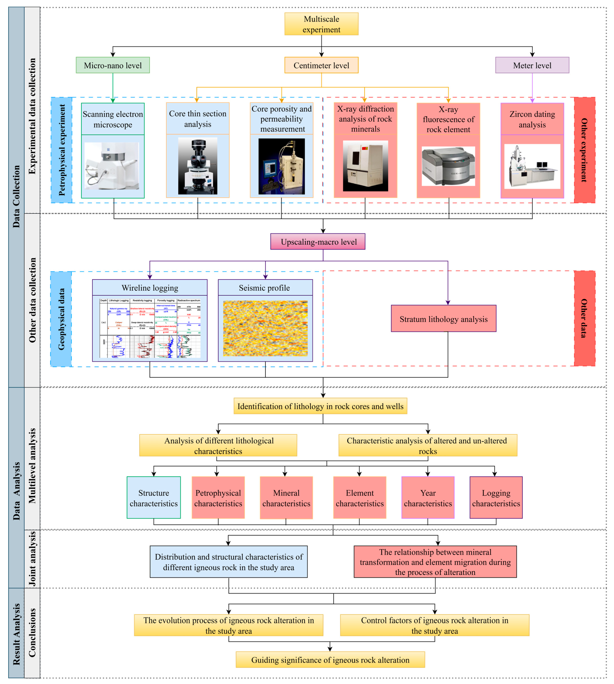
To achieve a comprehensive understanding of the geological processes in the Huizhou Depression, this study proposes a structured workflow framework including data collection, analysis, and interpretation of results, as illustrated in Figure 2.
Data collection involves conducting a broad spectrum of geophysical, mineralogy, and geochemical analyses on rock core and rock debris samples obtained from various depths within the buried hills. The analysis framework spans micro to nano-scale analyses, such as scanning electron microscopy (SEM) and zircon uranium-lead dating; centimeter-scale assessments, including core thin section analysis, porosity and permeability measurements, X-ray diffraction (XRD) for mineral identification, and X-ray fluorescence (XRF) for elemental composition analysis; meter-scale investigations, such as wireline logging and elemental cutting log, and upscaling-macro scale data such as seismic profiling. The samples used in the research are from the the Pearl River Mouth Basin in China. Except for the zircon dating instrument from Tongji University in Shanghai, China, all other equipment comes from Jilin University in Changchun, China.
To enhance the analytical techniques mentioned above, this study integrates advanced data analysis methods. We selected the K-nearest neighbor (KNN) algorithm for lithology identification due to its proven robustness in classifying complex igneous formations [47,48], achieving 95.6% test accuracy. Chemical Isoconcentration Line Analysis (ISOCON) is employed to study the elemental migration between rock samples and hydrothermal fluids [49]. This comprehensive methodological approach is designed to provide a detailed understanding of the complex geological history within the study area.
After determining the lithological information of the sample based on rock thin sections, typical rock cores of different lithologies were selected to carry out the above-mentioned multi-scale data collection work. These analyses aim to elucidate geological ages, physical properties, rock textures, mineralogy, and chemical compositions using multi-scale data. The combination of petrophysical and mineralogical data can be used to analyze the relationship between mineral changes and changes in rock porosity and permeability caused by different alteration. Mineralogy and elemental analysis can provide reliable evidence for the migration patterns of elements during alteration processes. The combination of laboratory core data and well data can restore the lithological distribution characteristics in the formation. By incorporating rock age information and up-scaling seismic data, this article can utilize multi-scale data to study the relationship between alteration characteristics and Earth activity.

2.2.2. Petrophysics Experiment

(1) Scanning electron microscope
Scanning Electron Microscopy (SEM) bridges the analytical capabilities of transmission electron microscopy and optical microscopy. Its straightforward sample preparation permits minimal processing of bulk or powdered specimens or direct imaging, allowing researchers to observe micro-morphology approximating the material’s natural state.
We utilized a ZEISS thermal field emission scanning electron microscope in this study. The instrument collects, amplifies, and reconstructs various physical signals of specimen into images to characterize rock micro-morphology. Before sample testing, it is necessary to perform electron beam calibration, detector calibration, stage and magnification calibration based on standard samples. In actual testing, it is necessary to evaluate the test results and obtain accurate results through more than 5 repeated experiments.
(2) Core thin section identification
Thin section analysis plays an essential role in characterizing reservoir properties. This technique involves mounting rock core slices approximately 0.03 mm thick (allowing visible light transmission) between glass slides for examination under an optical microscope. This process enables observation of pore structures and interstitial materials within the thin section.
This paper uses Olympus BX51 polarizing microscopes to identify polarizing films, which are based on the principles of Optics. After partial staining treatment of the rock slice, we select appropriate magnification under a polarizing microscope. By leveraging the distinct optical properties (particularly birefringence) of different minerals in the thin section, we identify mineral types while simultaneously examining grain size, sorting, and roundness, pore shape and size, distribution relationships of authigenic minerals within pores. Based on thin section images, obtain rock lithology information through multiple rounds of verification.
(3) Porosity and permeability
Core porosity and permeability are critical parameters for reservoir evaluation. Consequently, their measurement constitutes a fundamental experiment for analyzing petrophysical properties.
The principle of porosity measurement is based on Boyle’s Law. During testing, gas undergoes isothermal expansion from a reference chamber of known volume at a set initial pressure into a core chamber at atmospheric pressure. As the gas diffuses into the rock pore space, the resulting pressure change, combined with the known volumes, allows calculation of the effective pore volume and grain volume of the core sample using the gas law equation. Porosity is then derived from these volumes.
Permeability determination employs the transient pressure pulse decay technique, a non-steady-state method. Pore pressure is applied to the core, followed by the transmission of a differential pressure pulse through it. As the pressure transient propagates, a computer data acquisition system records the pressure differential across the core, downstream pressure, and time. The software plots logarithmic curves of differential pressure and mean pressure versus time. Permeability is calculated via linear regression analysis of the pressure-time data, with results stored in data files. Using minimal pressure differentials minimizes non-Darcy flow effects. Conducting multiple measurements at varying pore pressures yields the Klinkenberg-corrected permeability.
This paper uses the AP-608 Automated Porosimeter-Permeameter for measurements. After calibrating the instrument with standard samples, we take subjected to >10 repeated measurements for each sample and calculate the absolute deviation of porosity and relative deviation of permeability separately. When deviations meet experimental requirements, we take the value with the smallest deviation as the final result. Porosity absolute deviation must not exceed 0.5 p.u., while permeability relative deviation for samples <1 mD must not exceed 15%.

2.2.3. Rock Mineralogical Analysis

X-ray diffraction (XRD) analysis technology is an important means of analyzing the mineral composition. It can analyze different types of crystalline (including quasicrystalline) substances and then qualitatively or quantitatively determine the types and contents of each phase. Mineral analysis through XD-6 X-ray diffractometer (XRD) have revealed significant differences between altered and unaltered igneous rocks.
When X-rays pass through a crystal, each crystalline substance has unique diffraction characteristics, which can be characterized by the interplanar spacing and relative intensity. The interplanar spacing is related to the shape and size of the unit cell, while the relative strength is related to the type of crystal particles and their positions in the unit cell. The diffraction data mesh spacing and relative intensity of any crystalline substance are inevitable reflections of its crystal structure, which will exhibit different diffraction angles and peak heights on the diffraction pattern, thereby identifying the composition of various crystalline substances. Before conducting the experiment, it is necessary to crush about 10 g of core into a powder sample of about 800 mesh, and then fill the powder sample into the measurement mold for measurement in an X-ray diffraction whole rock mineral analysis instrument. The instrument needs to undergo an empty sample stage scan before operation to complete zero background calibration. To avoid the influence of heterogeneity, the sample powder needs to be completely mixed and divided into five measurements. When the relative standard deviation of the test results is not higher than 1.5%, taking the result with the smallest deviation as the experimental result.

2.2.4. Elemental Analysis

X-ray fluorescence (XRF) core element analysis is a chemical analysis technique for core samples, with sample preparation requirements identical to those for XRD whole-rock mineral analysis. Unlike XRD, XRF utilizes the wave-particle duality of X-rays to measure the relative contents of major and trace elements in rocks.
Major element analysis was carried out using the EDX6000B X-ray fluorescence (XRF) spectrometer. During the operation of the instrument, when X-rays irradiate the core powder sample, characteristic X-rays of various wavelengths (X-ray fluorescence) can be excited in the sample. Then, the mixed X-rays are separated by energy (or wavelength), and the intensity of X-rays of different energies (or wavelengths) is measured separately to analyze the content of different elements in the spectrum. Prior to sample analysis, the instrument must undergo energy scale calibration and intensity response calibration using certified reference materials. Subsequently, a homogenized sample is subjected to >10 repeated measurements. The data point exhibiting the smallest deviation is adopted as the final experimental result when all elemental measurements satisfy predefined tolerance criteria.

2.2.5. Zircon Uranium Lead Dating Detection

Zircon U-Pb dating determines rock ages, provides chronological constraints for regional tectonic activities, effectively traces source area characteristics and backgrounds, and elucidates intrinsic relationships between basin subsidence and major thermo-tectonic events.
The fundamental principle of isotopic dating relies on the radioactive decay law. By measuring the concentrations of parent isotopes and their daughter isotopes produced through decay, formation ages are calculated using this decay law. Specifically, zircon U-Pb dating primarily targets radioactive elements U and Th (which decay to Pb isotopes) within zircon. Utilizing the abundant age information preserved in zircon crystals, this method identifies provenances of detrital materials from different periods within rock fragments.
Zircon U-Pb isotope dating was completed using Laser ablation-inductively coupled plasma-mass spectrometry (LA-ICP-MS) analysis. The laser ablation system is New Wave 213 nm, and the ICP-MS model is Thermo Elemental X-Series. For each sample analysis, data acquisition comprises approximately 25 seconds of blank signal measurement followed by 50 seconds of sample signal measurement. During U-Pb isotopic dating, zircon reference material 91500 (1065.4 ± 0.3 Ma) serves as an external standard for instrumental mass fractionation correction, with two analyses of 91500 performed following every six unknown sample analyses. Concurrently, zircon standard Plešovice (337.1 ± 0.4 Ma) is analyzed to monitor analytical precision.

3. Results

3.1. Experimental Results

3.1.1. Petrography

(1) Lithological identification
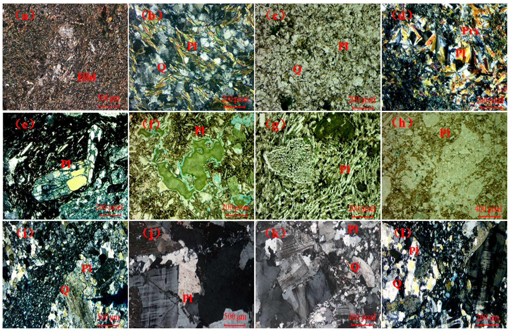
The cross-polarized light thin sections of 149 cores from X-1 and X-2 well areas in the Huizhou Depression, Pearl River Mouth Basin, northern part of the South China Sea, indicate a diverse assembly of igneous rocks, ranging from mafic to felsic rock types (Figure 3). Signs of alteration are observed in approximately half of the samples. Notably, granite exhibits both hydrothermal and weathering alterations. This comprehensive examination has led to the categorization of the core samples into 12 distinct types: 10 samples of diorite, 32 tectonic schists, 2 diabase, 10 altered diabase, 4 basalt, 2 altered basalt, 31 andesite, 21 altered andesite, 14 granite, 5 altered granite, 6 weathered granite, and 12 granodiorite.
Diorite displays porphyroblastic and blastoporphyritic textures; its matrix contains fine-grained, columnar hornblende and exhibits schistose structure. Minor plagioclase and quartz occur within it (Figure 3a). Tectonic schist shows lepidoblastic texture and gneissose structure, dominated by plagioclase and quartz. K-feldspar appears sparingly, its surfaces displaying significant alteration (Figure 3b). Diabase exhibits crystalloblastic texture with micro-bedding structures, containing plagioclase, quartz, and pyroxene as primary constituents (Figure 3c). Altered diabase develops unequigranular texture and inhomogeneous structure, holding plagioclase, pyroxene, and chlorite with accessory pyrite (Figure 3d). Basalt possesses vitrophyric texture; plagioclase dominates its matrix (Figure 3e). Altered basalt maintains porphyritic texture with plagioclase-rich matrix. Minor pyroxene occurs throughout. Almond-shaped vesicles commonly contain chlorite fillings (Figure 3f). Andesite features porphyritic and intergranular textures. Its matrix comprises microcline and microcrystalline pyroxene. Plagioclase demonstrates distinct orientation, with interstitial pyroxene grains separating crystals (Figure 3g). Altered andesite presents irregular morphology, bearing pyroxene phenocrysts. Its matrix displays heterogeneity—alternating between typical andesitic and devitrified textures. Plagioclase and quartz predominate; chlorite and illite contribute significantly (Figure 3h). Granite has coarse texture and massive structure, consisting mainly of microcline, perthite, plagioclase, and quartz (Figure 3i). Altered granite retains coarse texture and massive structure. Noticeably altered feldspar and quartz characterize it alongside recrystallized matrix (Figure 3j). Weathered granite contains tectonic breccias and porphyroclasts, composed dominantly of microcline, plagioclase, and quartz, indicating deformation history (Figure 3k). Granodiorite possesses fine-grained texture, containing predominantly K-feldspar with plagioclase and quartz. Dark minerals occasionally intersperse (Figure 3l).
(2) Porosity and permeability
The porosity values for these rocks range from 1.5% to 14.8%, with an average of 5.52% (Table 1). The porosity values of most rocks fall below 10%, categorizing them within the low porosity range. Permeability values span from 0.002 millidarcy (mD) to 8.850 mD, with the average permeability standing at 0.672 mD (Table 1). Permeability values are predominantly lower than 1 mD, leading to an ultra-low permeability category.
(3) Mineral components
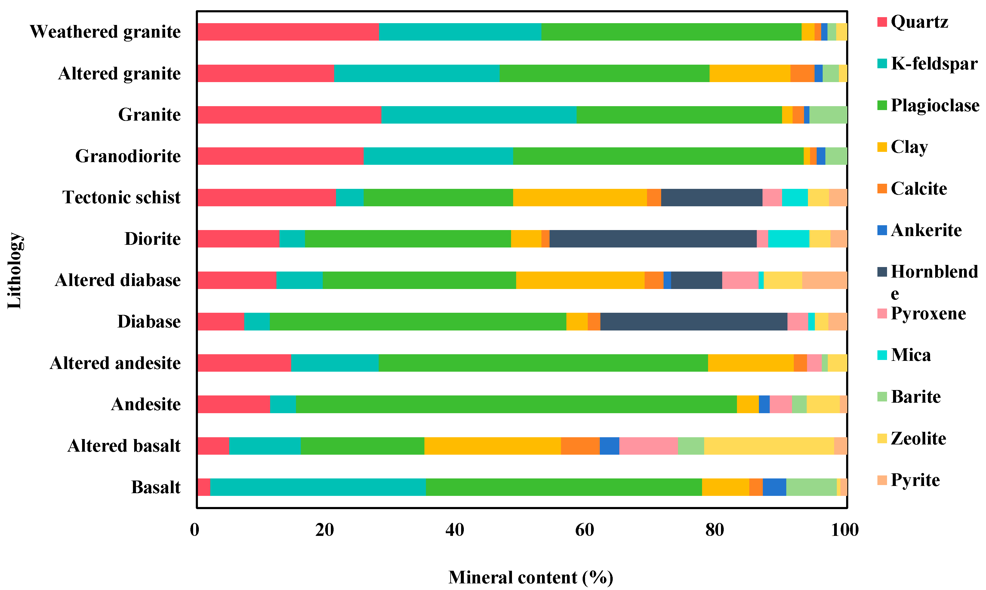
Altered rocks contain significantly more clay minerals than their unaltered counterparts. These clay minerals replace other mineral phases, demonstrating extensive alteration processes throughout the study area. Unaltered diorite consists primarily of hornblende (31.87%) and plagioclase (31.70%), with smaller quantities of quartz (12.73%), zeolite (3.23%), and minor clay minerals (4.67%). Tectonic schist (diorite’s altered equivalent) shows a sharp decrease in hornblende (15.57%) and plagioclase (22.97%), while hosting substantially more clay minerals (20.57%). This study consistently documents reduced primary minerals alongside increased clay content across multiple rock types, highlighting the transformative impact of alteration processes (Figure 4).
(4) Elemental composition
A significant loss of core samples during earlier analyses and the challenges associated with resampling prevented the measurement of two types of cores, diabase and altered basalt. Furthermore, since granodiorite does not have an altered counterpart, no major element measurements were performed on it. The mean values of 10 standardized major element oxides ( Na 2 O , MgO , Al 2 O 3 , Si O 2 , P 2 O 5 , K 2 O , CaO , Ti O 2 , MnO , and Fe 2 O 3 ) for nine different core types are reported in Table 2.

3.1.2. Geochronology

Zircon dating of 20 rock debris offered critical insights into geological ages of rocks in the Huizhou Depression, which were selected samples based on lithology identification. After testing multiple age measurement points for each zircon sample, data points with larger errors are removed, and then grouped according to age to obtain age ranges and weighted average ages. The final determination of the geological age of different samples is shown in Table 3.
For Well X-1-1, debris sample ages predominantly span 105–254 Ma, aligning with Cretaceous and Jurassic periods. The 3947–3957 m depth interval reveals notable age variation, indicating complex material sources and geological activities. Wells X-1-2 and X-1-4 yield geological ages of 110–144 Ma and ~116 Ma, respectively, primarily within Cretaceous–Jurassic strata and featuring a pronounced Yanshanian peak. Well X-2-1 encompasses 57–141 Ma (Paleogene–Cretaceous–Jurassic), while Well X-2-2 registers 50–140 Ma (mainly Cretaceous). Well X-2-3 exhibits the broadest age range (46–2715 Ma). This substantial variation likely reflects source effects, where 2599 Ma zircon grains likely ascended via deep-crustal magma upwelling, thereby recording deep crustal formation ages.

3.2. Drilling Data Processing

3.2.1. Lithology Identification in the Well

The core samples available were insufficient to fully reconstruct the lithology profiles within the wells. And the integration of logging data with the K-nearest neighbor (KNN) algorithm has been proven to effectively address complex lithological classification problems [50,51]. Using the rock lithology identification results verified by multiple geologists as labels, a total of 412 lithology data points were collected in this article, not solely from the wells of immediate interest but also from additional wells within the same study area, at various depths. The input wireline logging data for the KNN include nature gamma ray, compensated neutron, compensated density, acoustic time difference, and resistivity, along with magnesium and aluminum element contents from elemental cutting logging data. The lithology of each data point is determined by microscopic identification of core samples or through analysis of debris from wireline logging. The whole dataset is split into a training set and a test set, allocating 80% to training and 20% to testing. After comparing and analyzing different algorithms such as the Support vector machine and eXtreme Gradient Boosting, KNN is currently the most effective method for lithology recognition in this environment. The K value of 4 returns the highest accuracy, achieving 92.2% for the training set and 95.6% for the test set. These high accuracy rates underscore the reliability of KNN for lithology identification in this study. The KNN model was subsequently applied to the wells of interest, with logging data collected at a 0.125 m interval across all wells.
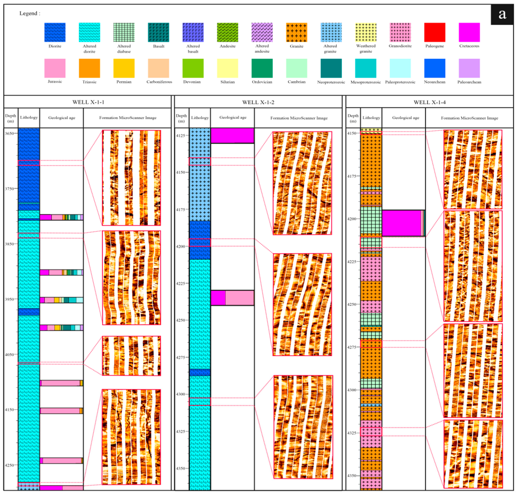
The lithology results based on KNN show that Wells X-1-1, X-1-2, and X-1-3, located in the southwest of the Huizhou Depression, exhibit a similar lithology, primarily consisting of altered diorite, diorite and altered granite, with interbedded thin layers of intruding altered diabase (Figure 5). The alteration within these wells is notably pronounced at depths ranging from 3800 to 4375 m. Well X-1-4, with its depth range of 4150 to 4350 m, mainly contains granodiorite, granite, and altered diabase with a lesser presence of altered and weathered granite. The X-2 series wells, situated in the northeast of the Huizhou Depression, span from 3300 to 5200 m depth, and have granite, andesite, altered andesite and basalt. Among these, Well X-2-1 mainly features altered andesite, interbedded with thin layers of basalt, and underlying granite. Well X-2-3 is dominated by andesite, and Well X-2-2 contains a variety of igneous rocks in interlayered forms.

3.2.2. Formation MicroScanner Images

In this study, Formation MicroScanner images (FMI), which are detailed electrical images of rocks, were collected to reveal the fracture characteristics of the study area. FMI results show that fractures are predominantly developed in the X-1 well area. Specifically, diorite shows continuous fractures, partly open fractures, and dissolution fractures, with fracture aperture gradually increasing with depth. Tectonic schist primarily exhibits partly open fractures and continuous fractures, alongside dissolution fractures, with larger fracture aperture and porosity near the surface, which tend to decrease with increasing depth. Altered diabase is also marked by partly open fractures and continuous fractures. Granite shows development of micro-fractures. In Well X-1-1, altered granite displays massive and layered structures, featuring continuous fractures and partly open fractures with significant porosity. Conversely, altered granite in Well X-1-2 is primarily characterized by massive structures, exhibiting a high degree of fracturing and secondary dissolution. Weathered granite shows the most extensive development of secondary dissolution. Granodiorite has massive structures, displaying discontinuous fractures and partially filled fractures.
The X-2 well area shows a prevalence of natural fractures. Dissolution fractures and continuous fractures are observed in andesite. Altered andesite and basalt mainly shows massive structure with natural fractures while granite, primarily massive structure, exhibits fewer fractures.

4. Discussion

4.1. Alteration Characteristics of Buried Hills

4.1.1. Core Alteration Characteristics

The igneous rocks of the buried hills have undergone a complex history, likely influenced by magmatic and tectonic activities, as well as regional climate changes. Many researchers hold the view that hydrothermal alteration can reduce the porosity and permeability of the rocks [52,53], whereas weathering can enhance reservoir capability. Therefore, weathering crusts in buried hills have significant research interest [36,54,55]. Surprisingly, recent studies have also revealed the reservoir potential in the altered rocks of buried hills [56].
This study primarily observes hydrothermal alteration, with some instances of weathering. Altered rock types include diorite, diabase, basalt, andesite, and granite, with granite undergoing both hydrothermal alteration and weathering while hydrothermal alteration and metamorphism for diorite. The extent and nature of alteration vary significantly due to the composition of the original rocks and changes in external environment [1]. The degree of alteration is commonly assessed by the content of clay minerals in the altered rocks [57]. In this study, the clay minerals identified in altered core samples are predominantly chlorite and illite, with their content generally ranging between 10 and 30%, indicating moderate alteration.
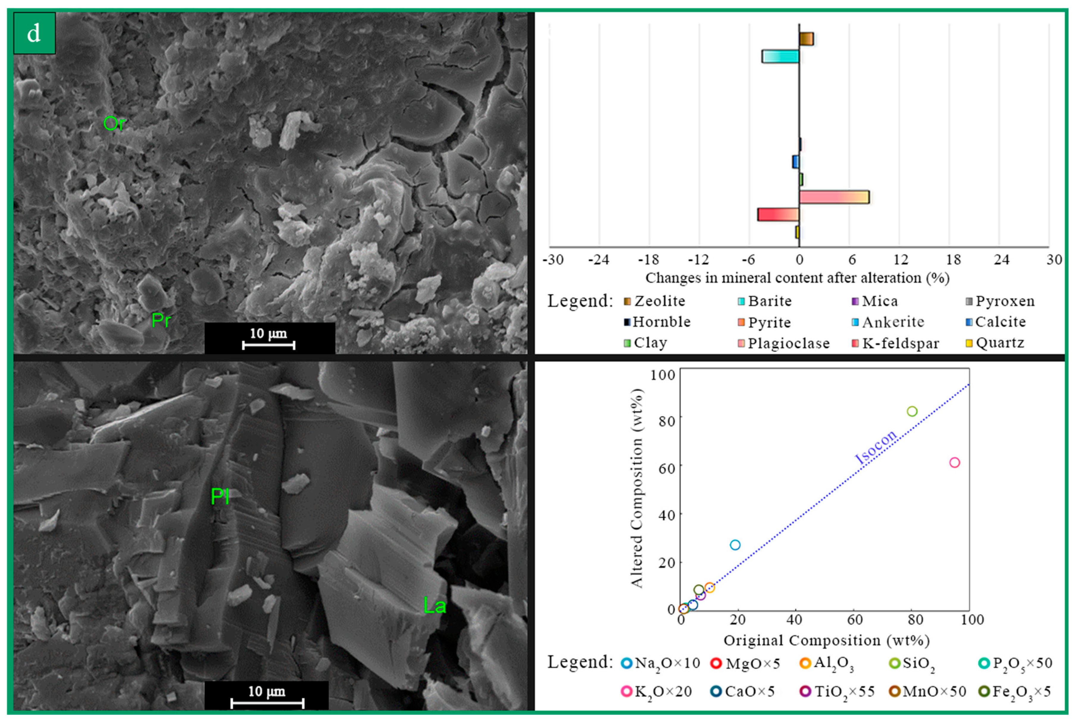
The SEM results indicate that the clay in rocks experiencing hydrothermal alteration are predominantly sheet-like or petal-shaped chlorite and fibrous illite, the mineral combination of hydrothermal alteration in diorite is hornblende–plagioclase–mica (Figure 6a), in andesite is plagioclase (Figure 6b), in granite is K-feldspar alteration (Figure 6c), and granite weathering is accompanied by dissolution of K-feldspar and carbonate minerals (Figure 6d). This is consistent with the changing characteristics shown in mineralogical data. It is worth noting that SEM images and core mineral analysis did not show significant presence of kaolinite. Studies show that the temperature conditions favoring the formation of chlorite are lower than those required for kaolinite [58]. Additionally, chlorite and illite serve as indicators of a dry and cool climate [59,60]. This alteration feature, which is mainly composed of chlorite and illite, supports the study area being in a dry and cool climate during the alteration process, and a detail future basin models should integrate to predict clay-dominated alteration.
The alteration characteristics were further analyzed using an Isocon plot, which offers insights into elemental changes due to alteration. The results show an increase in potassium (K) content in altered diorite and andesite compared to their unaltered counterparts, as illustrated in Figure 6a,b. This increase is consistent with the augmentation of K-feldspar observed in the XRD results (Figure 4). Conversely, a decrease in K content is observed in both the altered and weathered granite (Figure 6c,d). In other words, the changes in geochemical composition of these igneous rocks may not solely be attributed to the interaction between fluids and rocks during hydrothermal alteration. They could also be the result of partial melting and crystal fractionation associated with magmatic activity in the northern South China Sea, as well as the heterogeneity of the mantle source [19].

4.1.2. Alteration Characteristics in Well

Both X-1 and X-2 well areas expose diverse igneous rocks spanning mafic to felsic compositions. The X-1 well area primarily contains diorite (Figure 7a), while the X-2 well area hosts andesite (Figure 7b). Weathered granite occurs in Well X-1-4; compared to altered granite in adjacent wells, FMIs reveal more dissolution fractures in this unit. Altered rocks in these wells develop more extensive fracture networks than their unaltered counterparts. Unaltered basalt and granite particularly lack fractures or show minimal fracturing. This fracture–alteration correlation underscores tectonic activity’s pivotal role in driving alteration processes. Faulting generates fractures, increasing rock susceptibility to alteration by enabling deeper hydrothermal fluid penetration. The similar alteration patterns observed in diorite and andesite and the similar depths they are situated at may suggest that these two rock types could have experienced the same geological event during the Jurassic–Cretaceous. The fracture openings and fracture porosity in the tectonic schist are relatively large, aligning with the observed increase in permeability. The porosity of the altered andesite changes slightly compared to unaltered andesite, but the permeability of the altered andesite notably increases, likely due to the fractures. Additionally, multiple fracture types are overserved in granite and diorite. Given that continuous fractures are of tectonic origin, it suggests that the same lithology in the study area may have undergone various episodes of tectonic events.
From a conventional perspective, the phenomenon of improved pore conditions in rocks after dissolution can be explained by the increase in dissolution cracks caused by hydrothermal alteration and weathering, especially secondary dissolution cracks caused by weathering. This is also consistent with the experimental results of porosity and permeability in this paper, which has proven the better petrophysical properties of altered igneous rocks (Table 1). Paradoxically, studies have shown that secondary kaolinite does not have such a significant improvement effect on rock pore structure [29], but is more prone to water absorption, expansion, and pore blockage. Although the igneous rocks in the research area did not show significant kaolinite mineralization, the content of chlorite and illite in the altered rocks cannot be ignored. This indicates that during the process of alteration, the infiltration channels induced by tectonic movements, the dissolution of primary minerals, and the precipitation of secondary clay jointly affect the development of geological pore structure. The difference in physical properties between altered and unaltered igneous rocks is a comprehensive response of the pore structure of the original rock before alteration and the pore structure after alteration. The development of cracks is also an important condition for the occurrence of alteration. After the development of fractures in igneous rocks, they are more likely to come into contact with the formation hydrothermal fluid and undergo alteration. The alteration process further transforms the pore space and seepage channels, jointly creating the complex pore structure of altered igneous rock formations. Based on the current results, the hydrothermal alteration igneous rock formations in this study also have storage space and energy potential, which is different from previous understanding.

4.1.3. Alteration Characteristics on Temporal Scale

The zircon dating results show that the igneous rocks in the study area were mainly formed from the Late Jurassic to the Early Middle Cretaceous, with intense magmatic activity around 160 Ma and 114 Ma (Table 3). Magmatic history can be categorized into multiple stages. The first stage involves volcanic eruptions and magma intrusions around 160 Ma, producing basalt and andesite. These rocks constitute the main lithology of the buried hills. The second stage comes with magma intrusions around 144 Ma and 133 Ma, forming diabase and new diorite, and extensive granodiorite and granite, respectively; the third stage features large-scale magma intrusions around 114 Ma, resulting in the extensive existence of granite and diorite. And andesite displays younger source information (~50 Ma), it indicates that there may be small-scale volcanic activity during this period.
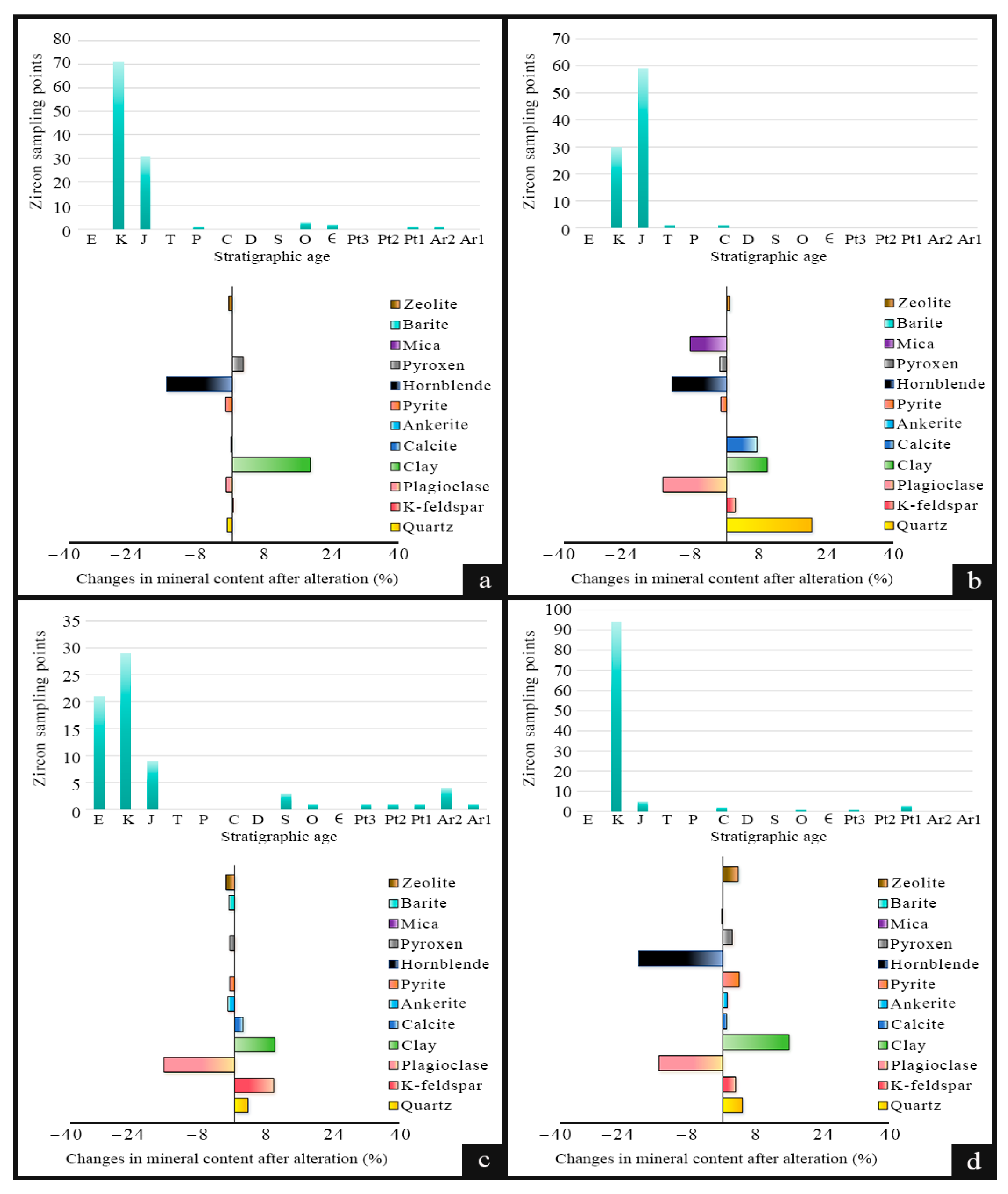
To further analyze the control effect of geological tectonic movements on hydrothermal alteration in different geological periods, the tectonic schists with significantly different geological periods such as Well X-1-2 and the 3800–4000 m in Well X-1-1 were discussed separately, and compared with the diabase of Well X-1-4 and the andesite with complexer material sources in X-2-1 well (Figure 8). The results indicate that multiple hydrothermal alterations have occurred in the study area, and there are differences in the alteration characteristics of different geological ages.
Obviously, the diagenesis time of each igneous rock is different, and alteration usually occurs after the development of cracks, so there are also differences in hydrothermal alteration at different periods. The original rock of the 3800–4000 m tectonic schist in Well X-1-1 was more formed during the Cretaceous period (Figure 8a), the original rock of the tectonic schist in Well X-1-2 was more Jurassic diorite (Figure 8b), the andesite in Well X-2-1 contains Jurassic, Cretaceous, and Paleogene sources (Figure 8c), and the original rock of the altered diabase in Well X-1-4 was formed during the Cretaceous period (Figure 8d). Temporally, Late Jurassic large-scale tectonic movements fractured diorite and andesite after their consolidation. These fractures enabled relatively low-intensity hydrothermal metasomatism, producing minerals like mica and plagioclase (Figure 8a,b). Increased quartz in tectonic schists likely relates to coeval oceanic crust subduction (Figure 8b). Cretaceous volcanic activity generated multi-phase diorite, andesite, and diabase. Subsequent hydrothermal fluids intensely metasomatized hornblende. During the Paleogene, andesite acquired younger sources (Figure 8c). Although diorite and diabase incorporated no new sources, all three rock types experienced strong plagioclase replacement. Minor potassium feldspar increases in tectonic schist/altered diabase, and quartz increases in altered andesite/diabase display weak alteration signatures; we omit further discussion of these subtle features. These similarities and differences reflect combined effects of regional tectonics and spatial rock distribution variations, necessitating detailed analysis with regional tectonic history.

4.2. The Alteration Cause of Buried Hills

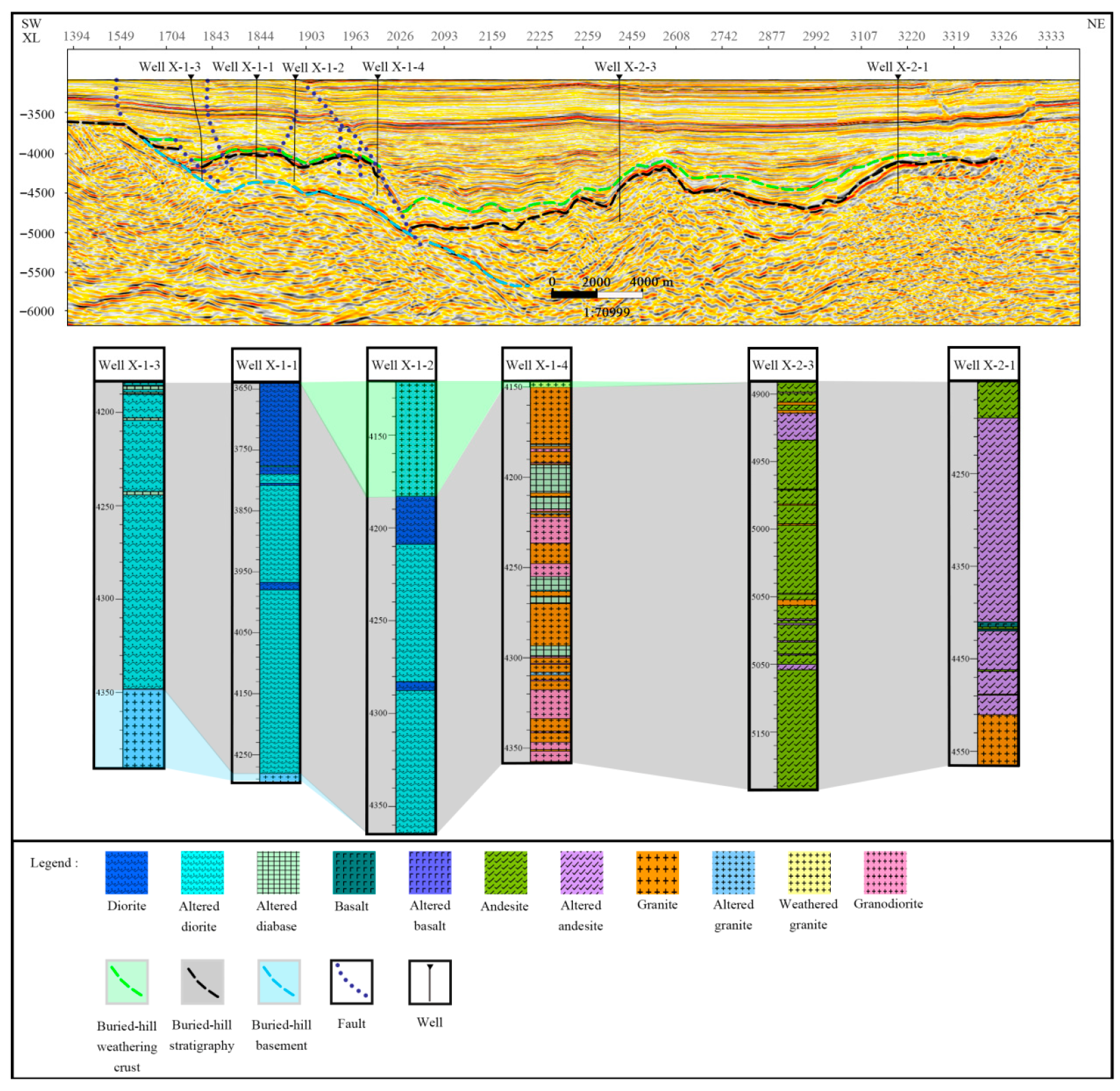
The tectonic movement in the research area is very complex, multiple pronounced faults are developed near the Wells X-1-1, X-1-2, and X-1-3 (Figure 9). Previous studies on the Mesozoic Paleo Tethys Plate and the ancient Pacific Plate, as well as multi-scale analysis conducted in this study, indicate that Huizhou Depression in the northern South China Sea experienced multiple episodes of tectonic activities and subsequent alteration, resulting in the complex buried hills’ structure depicted in Figure 9. To analyze the complex alteration mechanism in the study area, this paper proposes a four stage alteration model and conducts a detailed analysis and summary based on geological history.
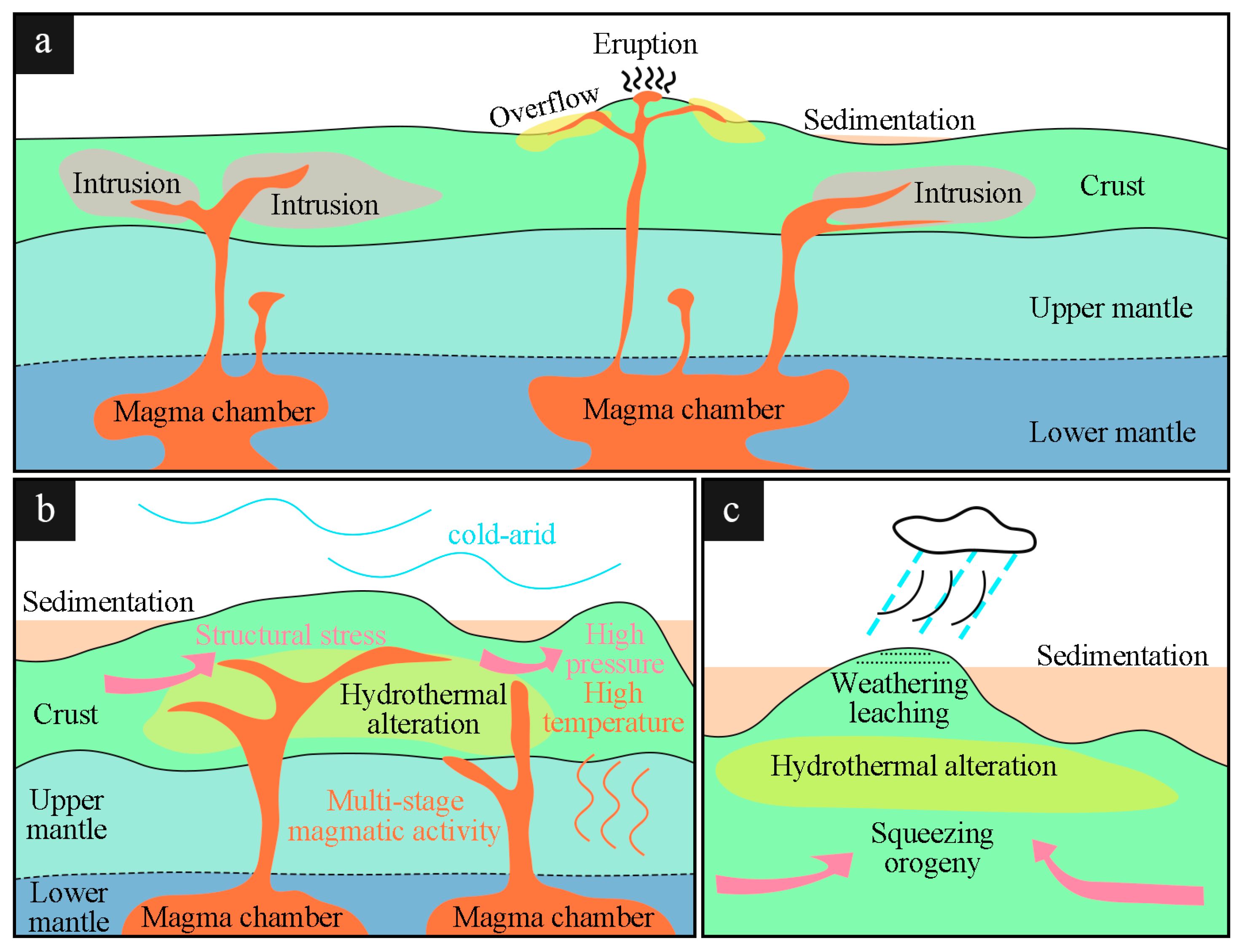
The first stage features alteration within the late Cretaceous Pacific Plate subduction setting. Although the Pacific Plate’s initial subduction timing remains uncertain [61], subduction commenced by the mid-late Jurassic (~160 Ma). The ancient Pacific Plate subducted beneath the South China Plate, triggering large-scale volcanic eruptions and magma intrusions across the study area (Figure 10a). Subsequent fractional crystallization and crustal assimilation of these magmas generated the buried hills primary lithology (Figure 9, gray shaded area), comprising basalt, andesite, and diorite. During continuous Pacific Plate subduction, tectonic fractures developed in these igneous rocks. These fractures facilitated plagioclase alteration, transforming diorite into tectonic schist and establishing pathways for later fluid–rock interactions. The characteristic quartz enrichment after alteration reflects active continental margin arc magmatism following oceanic crust subduction. This evidence demonstrates that northern South China Sea arc-related igneous rocks include not only Early Jurassic magnesian granites and diorites [62] but also Late Jurassic alkaline series rocks (basalt, andesite, tectonic schist), indicating sustained arc magmatism throughout the Jurassic. Our zircon ages (~160 Ma) and quartz enrichment in schists align with subduction-driven metasomatism.
The second stage involves hydrothermal alteration during the South China Plate’s orogeny. In the Early Cretaceous (145–120 Ma), regional compression uplifted the South China Plate, forming mountains. This compression generated NE-striking thrust faults and NEE/NW-striking secondary strike-slip faults, subsequently facilitating granite, diabase, and diorite intrusions in the X-1 well area. Global-scale volcanic eruptions coincided with this magmatic activity. Zircon dating reveals at least three diorite intrusions in the X-1 well area, followed by two granite/granodiorite intrusions, with diabase forming the latest and smallest bodies. Hydrothermal alteration during this stage primarily chloritized hornblende. Tectonic compression fractured diorite and andesite extensively, creating continuous fracture networks that enhanced hydrothermal fluid access and intensified alteration reactions. The widespread chlorite and illite, alongside absent kaolinite, likely reflects Cretaceous cold–arid climatic conditions (Figure 10b).
The third stage encompasses hydrothermal and weathering alteration driven by buried hills uplift. During the Late Cretaceous (110–66 Ma), tectonic movements elevated buried hills, exposing granite at the Earth’s surface where it underwent weathering. This weathering process likely initiated granite reburial through sedimentation or subsequent tectonic activity, following which hydrothermal fluids altered the rock (Figure 10c). The main characteristics of weathering and alteration are the dissolution of potassium feldspar and carbonate minerals, followed by the clay alteration of potassium feldspar in hydrothermal alteration. Both the weathering and hydrothermal alteration processes contributed to the development of numerous dissolution fractures. This series of events resulted in the formation of weathered granite and a buried hills weathering crust, as depicted in Figure 9 (highlighted in the green shaded area).
The fourth stage is hydrothermal alteration during the Early Paleogene (65.5–45 Ma), The changes in this stage may be related to the initial expansion of the South China Sea and require more research. The current ocean drilling work shows that the process of the South China Sea margin rift is more complex and lengthy than previously thought, and the hydrothermal altered basalt during the South China Sea rift period shows chloritization and albitization of plagioclase, jointly leading to the loss of calcium elements, and a station with hydrothermal alteration aged over 33 Ma was also found near the study area [19,40]. Although the altered basalt in the Pearl River Mouth Basin lacks time evidence of alteration, its location is close to the northern margin of the South China Sea, and there are plagioclase chloritization characteristics consistent with the above research. At the same time, significant dissolution of potassium feldspar occurred in the altered basalt in the study area. Theoretically, the lost potassium element will upflow with the underlying hydrothermal fluid and metasomatize with the overlying andesite, resulting in a significant increase in potassium feldspar in the altered andesite in the X-2 well area. These changes suggest that the initial expansion of the South China Sea may have occurred earlier than expected.

5. Conclusion and Future Work

This paper employs an integrated multi-scale geophysical–geochemical framework to characterize alteration features in buried hills igneous rocks within the Pearl River Mouth Basin, northern South China Sea. We establish a four-stage alteration model based on mineralogical and zircon geochronological data, reconstructing the alteration evolution and controls for these igneous systems. This model not only guides reservoir potential assessment in the Huizhou Depression but also has important significance for the history of continent–ocean transformation and rift expansion in the northern edge of the South China Sea. Key findings are as follows.
The igneous rocks in the northern South China Sea mainly undergo clay alteration with chlorite as the main product, which is mainly controlled by the arid–cold ancient climate of the Late Jurassic and Cretaceous. The migration pattern of potassium elements during the alteration process is controlled by the variation of potassium feldspar content, which can indicate the altered strata. Unlike previous understandings, the improved pore structure conditions of altered igneous rocks indicate that in addition to the well-known weathering crust, altered igneous rock formations also have energy storage potential. Note that the characteristics of mineral changes in altered andesite and altered basalt, as well as the young source exhibited by andesite, are consistent with the hydrothermal alteration characteristics of altered basalt during the South China Sea rift period [40], which also suggests that the initial expansion of the South China Sea may have occurred earlier than previously thought. Paradoxically, our alteration signatures hint at the South China Sea rifting initiating earlier than current models suggest. Future ocean drilling could test this by targeting Paleogene hydrothermal stations near the basin’s northern margin.
The controlling factors of igneous rock alteration characteristics have also been deciphered in research. Tectonic and magmatic processes jointly govern igneous rock alteration in the study area. Tectonically generated fracture networks and stratigraphic uplift enable hydrothermal metasomatism and weathering leaching. Magmatism triggered by distinct tectonic events not only produces varied igneous lithologies but also modifies hydrothermal fluid geochemistry, making the igneous rocks in the study area exhibit complex alteration mechanisms regulated by different minerals such as plagioclase, K-feldspar, and hornblende. This also suggests that different alteration patterns can serve as evidence for the existence of different tectonic activities. For example, hornblende alteration represents a long-term high-temperature and high-pressure environment, and the coexistence of weathering and alteration is related to mountain building movements. Alteration is also a trace of Earth’s activity, and this study awaits more igneous rock samples from around the world to enrich.

Abbreviation

Petrophysics: it is a discipline that studies the properties of rocks (such as porosity, permeability, conductivity, etc.) and their interactions with fluids, mainly through experimental measurements, data analysis, and model construction methods, applied in fields such as oil and gas exploration and reservoir evaluation. Hydrothermal alteration: the interaction between rocks and formation hydrothermal fluids in closed or semi closed environments. Weathered crust: after a certain period of weathering and erosion, a clear weathering and erosion zone is formed, which is then buried and compacted to form a “shell” or “shell zone”. Wireline logging: a method of obtaining formation data through logging instruments in boreholes. Element cutting logging: a method for analyzing the composition of formation elements based on rock cuttings generated during drilling process. SEM: scanning electron microscopy. Core thin section identification: the method of preparing rocks into thin sections and identifying rock composition and lithology through their optical characteristics. XRD: X-ray diffraction for mineral identification. XRF: X-ray fluorescence for elemental composition analysis. KNN: K-nearest neighbor algorithm. ISOCON: Chemical Isoconcentration Line Analysis. LA-ICP-MS: laser ablation-inductively coupled plasma-mass spectrometry. FMI: Formation MicroScanner images, a logging method for stratigraphic imaging.

Author Contributions

Methodology, X.W., B.P., Y.G., J.Z. and X.Y.; Data curation, X.W., B.P. and P.Z.; Writing—original draft, X.W., B.P., Y.G. and J.Z.; Writing—review & editing, X.W. and Y.G. All authors have read and agreed to the published version of the manuscript.

Funding

This research was funded by the National Natural Science Foundation of China grant number 42204122. And The APC was funded by Jilin University.

Conflicts of Interest

Author Pengji Zhang was employed by the company China National Offshore Oil Corporation (China) Limited Shanghai Branch. The remaining authors declare that the research was conducted in the absence of any commercial or financial relationships that could be construed as a potential conflict of interest.

References

  1. Wood, D.A.; Hazra, B. Characterization of Organic-Rich Shales for Petroleum Exploration & Exploitation: A Review-Part 2: Geochemistry, Thermal Maturity, Isotopes and Biomarkers. J. Earth Sci. 2017, 28, 758–778. [Google Scholar]
  2. Jiao, X.; Liu, Y.; Yang, W.; Zhou, D.; Bai, B.; Zhang, T.; Zhao, M.; Li, Z.; Meng, Z.; Yang, Y.; et al. Fine-grained volcanic-hydrothermal sedimentary rocks in Permian Lucaogou Formation, Santanghu Basin, NW China: Implications on hydrocarbon source rocks and accumulation in lacustrine rift basins. Mar. Pet. Geol. 2020, 114, 104201. [Google Scholar] [CrossRef]
  3. Oliver, P. Olivine—The Alteration Rock Star. Elements 2023, 19, 165–172. [Google Scholar] [CrossRef]
  4. Ma, B.; Gao, J.; Eriksson, K.A.; Zhu, H.; Liu, Q.; Ping, X.; Zhang, Y. Diagenetic alterations in Eocene, deeply buried volcaniclastic sandstones with implications for reservoir quality in the Huizhou depression, Pearl River Mouth Basin, China. AAPG Bull. 2023, 107, 929–955. [Google Scholar] [CrossRef]
  5. Tian, L. Genesis mechanism of tuffaceous materials in Paleogene large-scale glutenite reservoirs and implications for hydrocarbon exploration in the Huizhou Depression, Pearl River Mouth Basin. Earth Sci. 2022, 47, 452–463. [Google Scholar] [CrossRef]
  6. Lawal, L.; Adebayo, A.; Mahmoud, M.; Sultan, A.; Patil, S. Thermal maturation, mineral catalysis, and gas generation kinetics of carbonate source rock. J. Nat. Gas Sci. Eng. 2021, 92, 104003. [Google Scholar] [CrossRef]
  7. Zhang, B.; Wang, P.; Zhang, G.; Sun, X.; Lu, B.; Ni, W. Cenozoic volcanic rocks in the Pearl River Mouth and Southeast Hainan Basins of South China Sea and their implications for petroleum geology. Pet. Explor. Dev. 2013, 40, 704–713. [Google Scholar] [CrossRef]
  8. Zhu, S.; Cui, H.; Jia, Y.; Zhu, X.; Tong, H.; Ma, L. Occurrence, composition, and origin of analcime in sedimentary rocks of non-marine petroliferous basins in China. Mar. Pet. Geol. 2020, 113, 104164. [Google Scholar] [CrossRef]
  9. Jiu, B.; Huang, W.H.; Li, Y.; He, M. Influence of clay minerals and cementation on pore throat of tight sandstone gas reservoir in the eastern Ordos Basin, China. J. Nat. Gas Sci. Eng. 2021, 87, 103762. [Google Scholar] [CrossRef]
  10. Jowitt, S.; Jenkin, G.; Coogan, L.; Naden, J. Quantifying the release of base metals from source rocks for volcanogenic massive sulfide deposits: Effects of protolith composition and alteration mineralogy. J. Geochem. Explor. 2012, 118, 47–59. [Google Scholar] [CrossRef]
  11. Olavsdottir, J.; Andersen, M.S.; Boldreel, L.O. Reservoir quality of intrabasalt volcaniclastic units onshore Faroe Islands, North Atlantic Igneous Province, northeast Atlantic. AAPG Bull. 2015, 99, 467–497. [Google Scholar] [CrossRef]
  12. Sætre, C.; Hellevang, H.; Dennehy, C.; Dypvik, H.; Clark, S. A diagenetic study of intrabasaltic siliciclastics sandstones from the Rosebank field. Mar. Pet. Geol. 2018, 98, 335–355. [Google Scholar] [CrossRef]
  13. Wang, Y.; Liu, M.; Xi, K.; Cao, Y.; Wang, J.; Yuan, G.; Kashif, M.; Song, M. Characteristics and origin of the major authigenic minerals and their impacts on reservoir quality in the Permian Wutonggou Formation of Fukang Sag, Junggar Basin, western China. Mar. Pet. Geol. 2018, 97, 241–259. [Google Scholar] [CrossRef]
  14. Wang, X.; Zhang, X.; Lin, H.; Que, X.; He, Y.; Jia, L.; Xiao, Z.; Li, M. Paleogene geological framework and tectonic evolution of the central anticlinal zone in Lufeng 13 sag, Pearl River Mouth Basin. Pet. Res. 2019, 4, 238–249. [Google Scholar] [CrossRef]
  15. Shi, H.; Du, J.; Mei, L.; Zhang, X.; Hao, S.; Deng, P.; Zhang, Q. Huizhou Movement and its significance in Pearl River Mouth Basin, China. Pet. Explor. Dev. 2020, 47, 483–498. [Google Scholar] [CrossRef]
  16. Leng, J.; Liu, J.; Chen, A.; Cai, J.; He, L.; Hou, M.; Cao, H.; Huang, Z.; Zhong, L. Genesis of Mesozoic intermediate-basic volcanic reservoirs in Hui-Huizhou 26-6 buried hill, Pearl River Mouth Basin, China. J. Chengdu Univ. Technol. (Sci. Technol. Ed.) 2021, 48, 661–674. [Google Scholar]
  17. Zhang, X.; Liu, P.; Wang, W.; Du, J.; Chen, W. Controlling effect of tectonic transformation in Paleogene Wenchang Formation on oil and gas accumulation in Zhu I Depression. Earth Sci. 2021, 46, 1797–1813. [Google Scholar]
  18. Cui, Y.; Shao, L.; Li, Z.; Zhu, W.; Qiao, P.; Zhang, X. A Mesozoic Andean-type active continental margin along coastal South China: New geological records from the basement of the northern South China Sea. Gondwana Res. 2021, 99, 36–52. [Google Scholar] [CrossRef]
  19. Larsen, H.C.; Mohn, G.; Nirrengarten, M.; Sun, Z.; Stock, J.; Jian, Z.; Klaus, A.; Alvarez-Zarikian, C.A.; Boaga, J.; Bowden, S.A.; et al. Rapid transition from continental breakup to igneous oceanic crust in the South China Sea. Nat. Geosci. 2018, 11, 782–789. Available online: https://www.nature.com/articles/s41561-018-0198-1 (accessed on 26 April 2023). [CrossRef]
  20. Zahirovic, S.; Seton, M.; Müller, R.D. The Cretaceous and Cenozoic tectonic evolution of southeast Asia. Solid Earth 2014, 5, 227–273. [Google Scholar] [CrossRef]
  21. Morley, C.K. Major unconformities/termination of extension events and associated surfaces in the South China Seas: Review and implications for tectonic development. J. Asian Earth Sci. 2016, 120, 62–86. [Google Scholar] [CrossRef]
  22. Wu, J.; Suppe, J. Proto-South China sea plate tectonics using subducted slab constraints from tomography. J. Earth Sci. China 2018, 29, 1304–1318. [Google Scholar] [CrossRef]
  23. Li, S.; Suo, Y.; Li, X.; Zhou, J.; Santosh, M.; Wang, P.; Wang, G.; Guo, L.; Yu, S.; Lan, H.; et al. Mesozoic tectono-magmatic response in the East Asian ocean-continent connection zone to subduction of the Paleo-Pacific Plate. Earth-Sci. Rev. 2019, 192, 91–137. [Google Scholar] [CrossRef]
  24. Liu, Y.; Wu, Z.; Liu, L.; Yan, S.; Hu, L.; Ping, M.; Zhang, M. Cenozoic structure and tectonics of north subbasins in Beibu Gulf basin, northern South China Sea. Tectonophysics 2021, 812, 228912. [Google Scholar] [CrossRef]
  25. Ge, J.; Zhu, X.; Pan, R.; Lei, Y.; Zhang, X.; Chen, S. A quantitative porosity evolution model of sandstone for Wenchang Formation in the Huizhou Depression, Pearl River Mouth Basin: A case study from braided fluvial delta reservoir of HZ-A area. Acta Sedimentol. Sin. 2015, 33, 183–193. [Google Scholar]
  26. Ding, L.; Li, X.; Zhou, F.; Long, G.; Ma, Y.; Zhang, Y. Differential development characteristics and main controlling factors of the Paleogene high-quality reservoirs from the Zhu I Depression in the Pearl River Mouth Basin: A case on Wenchang Formation at Lufeng area and Huizhou area. Acta Petrol. Minera-Log. 2022, 41, 75–86. [Google Scholar]
  27. Robison, C.R.; Elord, L.W.; Bissada, K.K. Petroleum generation, migration, and entrapment in the Zhu 1 depression, Pearl River Mouth Basin, South China Sea. Int. J. Coal Geol. 1998, 37, 155–178. [Google Scholar] [CrossRef]
  28. Liu, L.; Zhang, J.; Sun, Z.; Shi, H.; Ding, L.; Du, J.; Yu, J.; Xie, J.; Wang, K. Constraints of three-dimensional geological modeling on reservoir connectivity: A case study of the Huizhou depression, Pearl River Mouth basin, South China Sea. J. Asian Earth Sci. 2019, 171, 144–161. [Google Scholar] [CrossRef]
  29. Jin, Z.; Yuan, G.; Zhang, X.; Cao, Y.; Ding, L.; Li, X.; Fu, X. Differences of tuffaceous components dissolution and their impact on physical properties in sandstone reservoirs: A case study on Paleogene Wenchang Formation in Huizhou-Lufeng area, Zhu I Depression, Pearl River Mouth Basin, China. Pet. Explor. Dev. 2023, 50, 111–124. [Google Scholar] [CrossRef]
  30. Peng, J.; Pang, X.; Peng, H.; Ma, X.; Shi, H.; Zhao, Z.; Xiao, S.; Zhu, J. Geochemistry, origin, and accumulation of petroleum in the Eocene Wenchang Formation reservoirs in Pearl River Mouth Basin, South China Sea: A case study of HZ25-7 oil field. Mar. Pet. Geol. 2017, 80, 154–170. [Google Scholar] [CrossRef]
  31. Zhao, F.; Alves, T.M.; Xia, S.; Li, W.; Wang, L.; Mi, L.; Wu, S.; Cao, J.; Fan, C. Along-strike segmentation of the South China Sea margin imposed by inherited prerift basement structures. Earth Planet. Sci. Lett. 2020, 530, 115862. [Google Scholar] [CrossRef]
  32. Shi, H.; Li, C. Mesozoic and early Cenozoic tectonic convergence-to-rifting transition prior to opening of the South China Sea. Int. Geol. Rev. 2012, 54, 1801–1828. [Google Scholar] [CrossRef]
  33. Zhang, C.; Zhang, J.; Wu, J.; Shi, X.; Zhao, C.; Yu, X. Summary and discussion on tuffaceous reservoir research progress. Fault-Block Oil Gas Field 2016, 23, 545–548. [Google Scholar]
  34. Ye, Q.; Mei, L.; Shi, H.; Camanni, G.; Shu, Y.; Wu, J.; Yu, L.; Deng, P.; Li, G. The Late Cretaceous tectonic evolution of the South China Sea area: An overview, and new perspectives from 3D seismic reflection data. Earth Sci. Rev. 2018, 187, 186–204. [Google Scholar] [CrossRef]
  35. Zheng, J.; Gao, Y.; Zhang, X.; Pang, W.; Zhang, Q.; Lao, M.; Feng, X. Tectonic evolution cycles and Cenozoic sedimentary environment changes in the Pearl River Mouth Basin. Earth Sci. 2022, 47, 2374–2390. [Google Scholar]
  36. Mi, L.; Fan, T.; Fan, H.; Niu, T.; Gong, L.; Su, X.; Sun, Y.; Cheng, Y. Fracture development and controlling factors at metamorphic buried-hill reservoirs of Bozhong 19-6 gas field in Bohai Bay, East China. Front. Earth Sci. 2023, 10, 1082439. [Google Scholar] [CrossRef]
  37. Jiang, H.; Pang, X.; Chen, D.; Peng, H.; Yu, Q.; Zhang, X. Characteristics of source rock controlling hydrocarbon distribution in Huizhou depression of Pearl River Mouth Basin, South China Sea. J. Pet. Sci. Eng. 2018, 171, 1260–1268. [Google Scholar] [CrossRef]
  38. Zhao, Q.; Zhu, H.; Zhang, X.; Liu, Q.; Qiu, X.; Li, M. Geomorphologic reconstruction of an uplift in a continental basin with a source-to-sink balance: An example from the Huizhou-Lufeng uplift, Pearl River Mouth Basin, South China Sea. Mar. Pet. Geol. 2021, 128, 104984. [Google Scholar] [CrossRef]
  39. Li, Y.; Yu, X.; Liu, H.; Huang, X.; Yue, W.; Lian, E.; Yang, S. Tectonic and magmatic evolution of NE Cathaysia Block controls sediment geochemical heterogeneity of rivers in SE China. CATENA 2023, 223, 106910. [Google Scholar] [CrossRef]
  40. Wu, J.; Liu, Z.; Yu, X. Plagioclase-regulated hydrothermal alteration of basaltic rocks with implications for the South China Sea rifting. Chem. Geol. 2021, 585, 120569. [Google Scholar] [CrossRef]
  41. Ge, J.; Zhu, X.; Zhao, X.; Liao, J.; Ma, B.; Jones, B.G. Tectono-sedimentary signature of the second rift phase in multiphase rifts: A case study in the Lufeng Depression (38–33.9 Ma), Pearl River Mouth Basin, South China Sea. Mar. Pet. Geol. 2020, 114, 104218. [Google Scholar] [CrossRef]
  42. Tian, L. Sedimentary-reservoir characteristics under control of transfer model and implications for hydrocarbon exploration in Huizhou Depression, Pearl River Mouth Basin. Earth Sci. 2021, 46, 4043–4056. [Google Scholar] [CrossRef]
  43. Yu, Y.; Zhang, T.; Zhang, Z.; Zhang, G.; Zeng, J.; Yang, H.; Zhao, Z.; Liang, W. Structural characteristics and its significances on hydrocarbon accumulation in the Yunkai low uplift, Pearl River Mouth basin. Acta Geol. Sin. 2021, 95, 21–29. [Google Scholar] [CrossRef]
  44. Hu, Y.; Hao, F.; Zhu, J.Z.; Tian, J.Q.; Ji, Y.B. Origin and occurrence of crude oils in the Zhu1 sub-basin, Pearl River Mouth Basin, China. J. Asian Earth Sci. 2015, 97, 24–37. [Google Scholar] [CrossRef]
  45. Lin, C.; Jiang, J.; Shi, H.; Zhang, Z.; Liu, J.; Qin, C.; Li, H.; Ran, H.; Wei, A.; Tian, H.; et al. Sequence architecture and depositional evolution of the northern continental slope of the South China Sea: Responses to tectonic processes and changes in sea level. Basin Res. 2017, 30, 568–595. [Google Scholar] [CrossRef]
  46. Li, M.; Zhang, S.; Snowdon, L.; Issler, D. Oil-source correlation in tertiary deltaic petroleum systems: A comparative study of the Beauforte-Mackenzie Basin in Canada and the Pearl River Mouth Basin in China. Org. Geochem. 2008, 39, 1170–1175. [Google Scholar] [CrossRef]
  47. Han, R.; Wang, Z.; Wang, W.; Xu, F.; Qi, X.; Cui, Y.; Zhang, Z. Igneous Rocks Lithology Identification with Deep Forest: Case Study from Eastern Sag, Liaohe Basin. J. Appl. Geophys. 2022, 208, 104892. [Google Scholar] [CrossRef]
  48. Han, R.; Wang, Z.; Guo, Y.; Wang, X.; A, R.; Zhong, G. Multi-label prediction method for lithology, lithofacies and fluid classes based on data augmentation by cascade forest. Adv. Geo-Energy Res. 2023, 9, 25–37. [Google Scholar] [CrossRef]
  49. Kuwatani, T.; Yoshida, K.; Ueki, K.; Oyanagi, R.; Uno, M.; Akaho, S. Sparse isocon analysis: A data-driven approach for material transfer estimation. Chem. Geol. 2020, 532, 119345. [Google Scholar] [CrossRef]
  50. Zhang, X.; Yusuke, N.; Hisao, I.; Hu, W.; Wang, S. Prediction by fuzzy clustering and KNN on validation data with parallel ensemble of interpretable TSK fuzzy classifiers. IEEE Trans. Syst. Man Cybern. Syst. 2022, 52, 400–414. [Google Scholar] [CrossRef]
  51. Wang, X.; Pan, B.; Guo, Y.; Wang, Q.; Guan, Y. Multi-scale data joint inversion of minerals and porosity in altered igneous reservoirs—A case study in the South China Sea. Pet. Sci. 2023, 21, 206–220. [Google Scholar] [CrossRef]
  52. Patricia, S.; Nora, R. Processes controlling porosity and permeability in volcanic reservoirs from the Austral and Neuquén basins, Argentina. AAPG Bull. 2007, 91, 115–129. [Google Scholar] [CrossRef]
  53. Duffy, M.; Farrell, N.; Raeside, R.; Muirhead, D.; Healy, D.; Brasier, A.; Schofield, N. Observations of reservoir quality alteration in proximity to igneous intrusions for two distinct sandstones in Scotland. Mar. Pet. Geol. 2021, 129, 10507. [Google Scholar] [CrossRef]
  54. Zhang, X.; Yao, Y.; Zhang, G.; Ma, R.; Wang, Z. Natural fractures in a metamorphic buried hill reservoir, Bozhong 19-6 area, Bohai Bay Basin, China. Mar. Pet. Geol. 2023, 155, 106402. [Google Scholar] [CrossRef]
  55. Fan, T.; Du, X.; Fan, P.; Ma, S.; Liang, X.; Niu, T. Fault-Landform Double Controlled Archean Buried-Hill Reservoir Integrated Prediction for BZ26-6 Oil Field, Bohai Bay. Earth Sci. J. China Univ. Geosci. 2023, 48, 429–438. [Google Scholar]
  56. Deng, Y.; Wang, H.; Heng, L.; Yang, J.; Chen, S. Lithofacies-controlled Fracture Modeling and Quality Control Methods for Complex Lithology Igneous Buried Hill Rrservior: Taking Igneous Buried Hill Rrservior of Huizhou 26-6 Oilfield as an Example. Sci. Technol. Eng. 2023, 23, 7671–7677. (In Chinese) [Google Scholar]
  57. Pan, B.; Wang, X.; Guo, Y.; Zhang, L.; Ruhan, A.; Zhang, N.; Zhang, P.; Li, Y. Study on reservoir characteristics and evaluation methods of altered igneous reservoirs in Songliao Basin, China. J. Pet. Sci. Eng. 2022, 212, 110266. [Google Scholar] [CrossRef]
  58. Liu, X.; Zhao, D.; Zhu, S.; Wu, D.; Zhu, X. Authigenic minerals and diagenetic evolution in altered volcanic materials and their impacts on hydrocarbon reservoirs: Evidence from the lower Permian in the northwestern margin of Junggar Basin, China. Arab. J. Geosci. 2016, 9, 97. [Google Scholar] [CrossRef]
  59. Retallack, G.J. Pedogenic carbonate proxies for amount and seasonality of precipitation in paleosols. Geology 2005, 33, 333–336. [Google Scholar] [CrossRef]
  60. Craggs, H.J.; Valdes, P.J.; Widdowson, M. Climate model predictions for the latest Cretaceous: An evaluation using climatically sensitive sediments as proxy indicators. Palaeogeogr. Palaeoclimatol. Palaeoecol. 2012, 315–316, 12–23. [Google Scholar] [CrossRef]
  61. Isozaki, Y.; Aoki, K.; Nakama, T.; Yanai, S. New insight into a subductionrelated orogen: A reappraisal of the geotectonic framework and evolution of the Japanese Islands. Gondwana Res. 2010, 18, 82–105. [Google Scholar] [CrossRef]
  62. Xu, C.H.; Zhang, L.; Shi, H.S.; Brix, M.R.; Huhma, H.; Chen, L.H.; Zhang, M.Q.; Zhou, Z.Y. Tracing an early Jurassic magmatic arc from South to East China Seas. Tectonics 2017, 36, 466–492. [Google Scholar] [CrossRef]
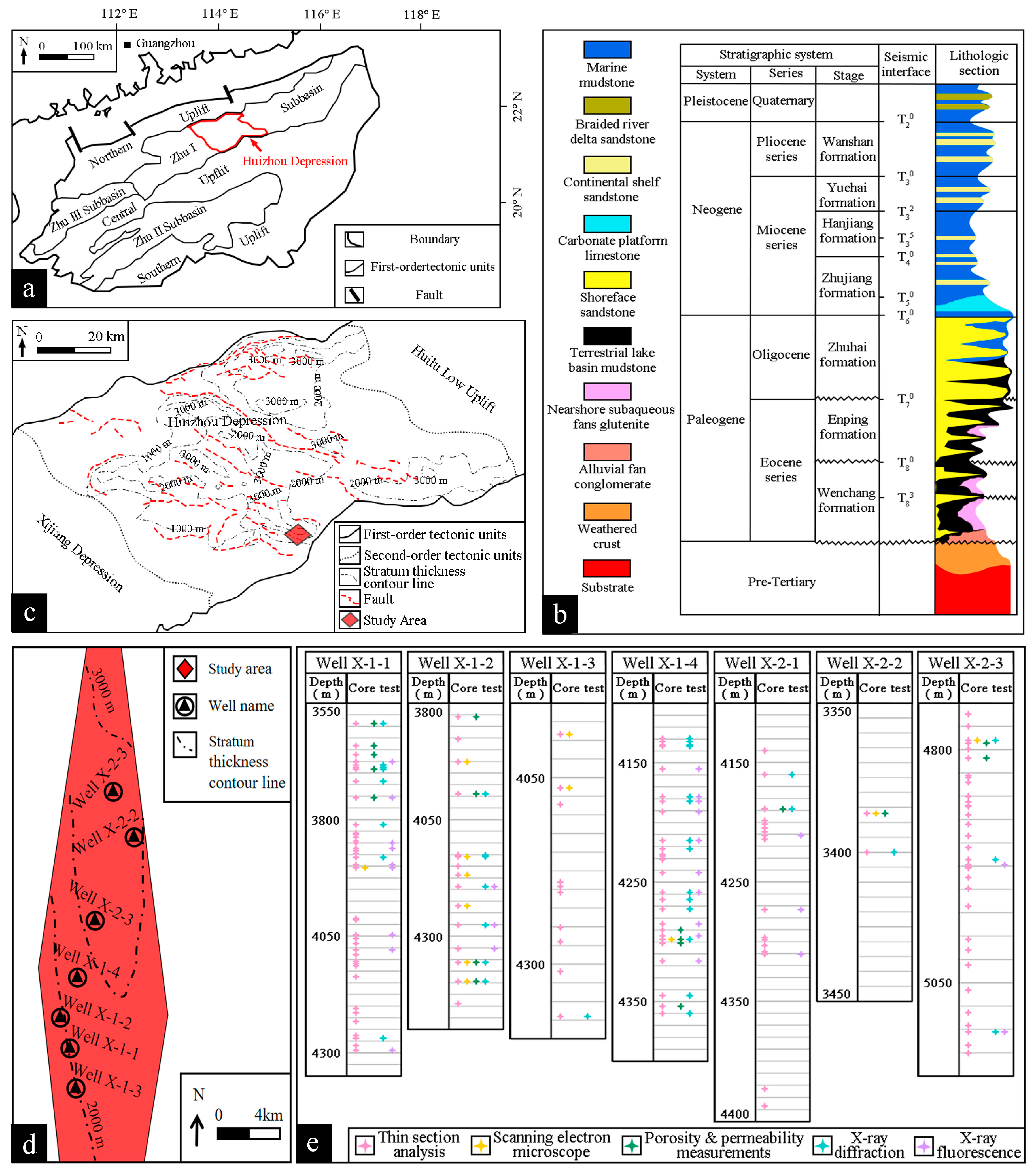
Figure 1. General Situation of the study area: (a) the Pearl River Mouth Basin; (b) geological map of Huizhou Depression; (c) drilling location; (d) X-1 and X-2 well areas; (e) sampling information.
Jmse 13 01549 g001
Figure 2. Workflow of multi-scale analysis method.
Jmse 13 01549 g002
Figure 3. Representative core samples under the microscope (Pl is plagioclase; Q is quartz; Hbl is hornblende; Prx is pyroxene): (a) diorite; (b) tectonic schist; (c) diabase; (d) altered diabase; (e) basalt; (f) altered basalt; (g) andesite; (h) altered andesite; (i) granite; (j) altered granite; (k) weathered granite; (l) granodiorite.
Jmse 13 01549 g003
Figure 4. The average content of minerals from different core types.
Jmse 13 01549 g004
Figure 5. Identification results of geological lithology based on K-nearest neighbor algorithm.
Jmse 13 01549 g005
Figure 6. SEM images of selective core samples and corresponding Isocon plots (for each image, the upper left and lower left show SEM images of unaltered rocks and altered rocks, respectively; the upper right figure outlines the mineralogical changes after alteration, and lower right presents Isocon diagrams, detailing the elemental migration patterns due to alteration. Hbl in the SEM images represents hornblende, and Ab, Ch, Pl, Or, Pr are for albite, chlorite, plagioclase, K-feldspar and pyrite, respectively): (a) diorite; (b) andesite; (c) altered granite; and (d) weathered granite.
Jmse 13 01549 g006aJmse 13 01549 g006bJmse 13 01549 g006c
Figure 7. Lithology and geological age results: (a) X-1 well area; (b) X-2 well area.
Jmse 13 01549 g007aJmse 13 01549 g007b
Figure 8. Comparison of altered minerals changes in different geological ages (N is Neogene; E is Paleogene; K is Cretaceous; J is Jurassic; T is Triassic; P is Permian; C is Carboniferous; D is Devonian; S is Silurian; O is Ordovician; ∈ is Cambrian; Pt3 is Neoproterozoic; Pt2 is Mesoproterozoic; Pt1 is Paleoproterozoic; Ar2 is Neoarchean; Ar1 is Paleoarchean): (a) the tectonic schist at the 3800–4000 m in Well X-1-1; (b) the tectonic schist in Well X-1-2; (c) the andesite in the Well X-2-1; (d) the diabase in the Well X-1-4.
Jmse 13 01549 g008
Figure 9. Structural map of key well sections in Huizhou Depression, northern South China Sea.
Jmse 13 01549 g009
Figure 10. Pattern diagram of alteration model: (a) The generation of the theme lithology of buried hill. (b) The alteration environment under the influence of multi-stage volcanic activity in the Jurassic and Cretaceous periods. (c) The alteration environment during the buried hill uplift period.
Jmse 13 01549 g010
Table 1. Core porosity and permeability in the research area.
LithologyPorosityPermeability
%mD
Diorite1.70.002
2.70.006
Tectonic schist3.81.990
4.30.029
Diabase1.50.005
Altered diabase10.48.850
4.20.005
Basalt6.90.004
70.005
Altered basalt14.80.002
Andesite5.90.011
Altered andesite6.70.007
4.90.030
Granite2.40.002
Altered granite5.60.453
Weathered granite4.40.014
Granodiorite6.70.003
Table 2. Mean major element compositions of different rock types sampled in Huizhou Depression.
LithologyNa2OMgOAl2O3SiO2P2O5K2OCaOTiO2MnOFe2O3
wt%wt%wt%wt%wt%wt%wt%wt%wt%wt%
Diorite2.19 5.45 15.46 56.90 0.36 2.27 6.95 0.81 0.21 9.41
Tectonic schist2.62 6.19 13.08 60.59 0.30 2.12 5.98 0.66 0.18 8.25
Altered diabase2.57 5.29 12.78 68.39 0.09 2.47 2.84 0.50 0.10 4.97
Basalt3.19 5.38 16.95 52.04 0.63 1.50 8.52 1.68 0.23 9.87
Andesite1.82 2.33 19.30 59.53 0.20 2.42 6.84 0.71 0.12 6.73
Altered andesite5.46 2.47 19.74 57.77 0.18 2.80 4.46 0.80 0.08 6.23
Granite1.91 0.39 10.30 80.27 0.04 4.75 0.89 0.13 0.03 1.30
Altered granite1.69 8.29 13.49 61.24 0.14 1.69 5.77 0.79 0.15 6.75
Weathered granite2.72 0.24 9.62 82.20 0.02 3.05 0.50 0.12 0.02 1.50
Table 3. Zircon age determination results in the study area.
Well NameSample
Number
Top DepthBottom DepthAge
Range
206Pb/238Uaverage Age
mmMaMa
X-1-1137973807108–126116
137–167153
23897390798–124110.8
146–164154.3
339473957126–2374105.3
439974007101–141118
251–263254
540974107151–174162.7
641474157147–189163.8
742374247126–181155.4
842874297112–157133.8
X-1-2141204130/110
242304240/144
X-1-4141954210/116
X-2-114290430057–7361.6
106–141119.3
245404550106–135116.5
X-2-2133453354100–120112.4
233693378100–120111.4
333903399100–140114.7
248248
43399340850–7058.9
100–130113.4
53411342090–130111.3
634503459100–130114.2
X-2-314860488046–7055
151–160155.3
403–444419
893–895894
Disclaimer/Publisher’s Note: The statements, opinions and data contained in all publications are solely those of the individual author(s) and contributor(s) and not of MDPI and/or the editor(s). MDPI and/or the editor(s) disclaim responsibility for any injury to people or property resulting from any ideas, methods, instructions or products referred to in the content.