
Late Glacial and Holocene Paleoenvironmental Reconstruction of the Submerged Karst Basin Pirovac Bay on the Eastern Adriatic Coast

 ,
, 
 ,
,  ,
,
Abstract
1. Introduction
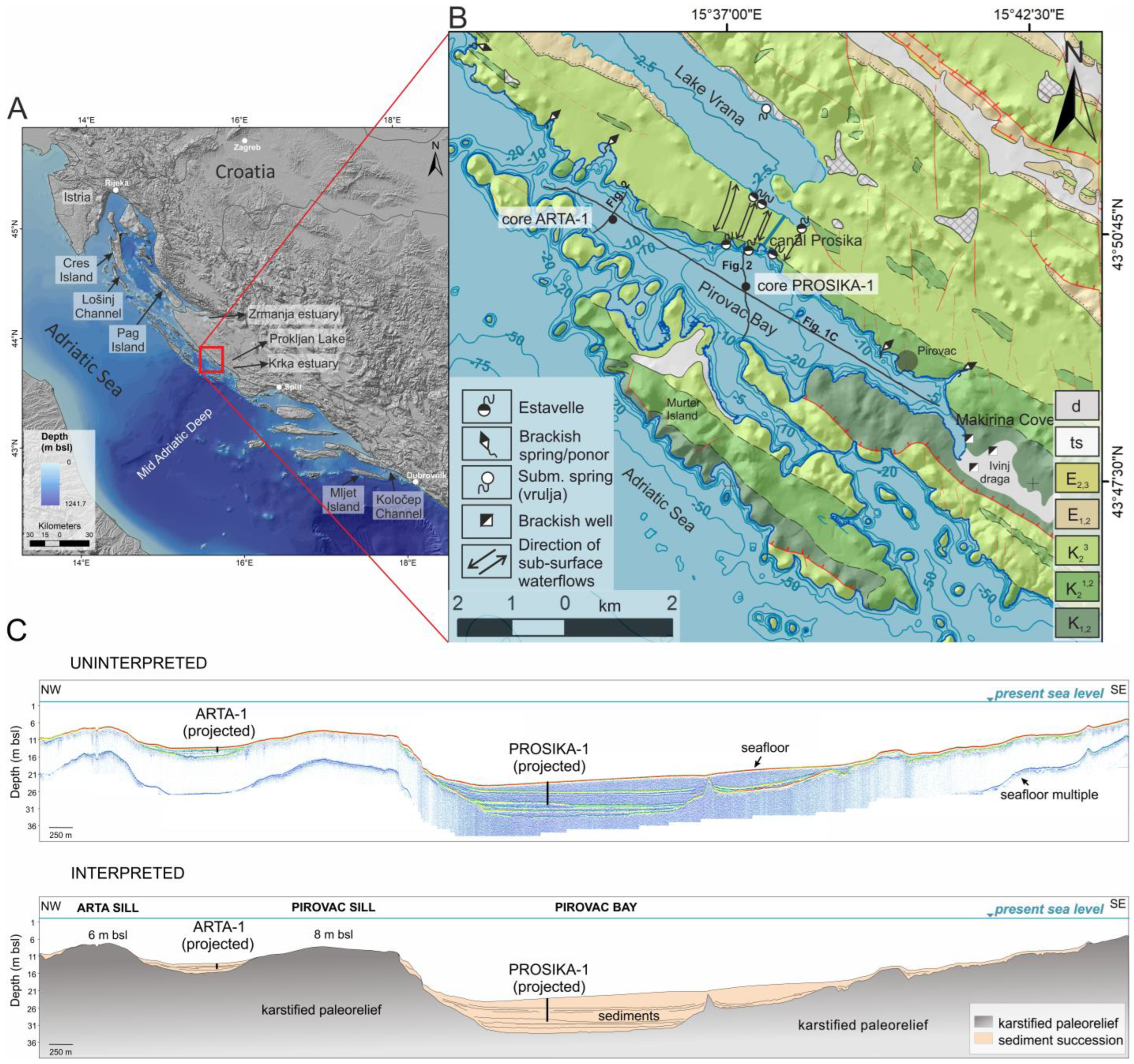
2. Study Site
3. Materials and Methods
3.1. Study Area Description
3.2. Hydroacoustic Survey
3.3. Sediment Cores Collection
3.4. Laboratory Analyses
3.5. Statistical Methods
4. Results
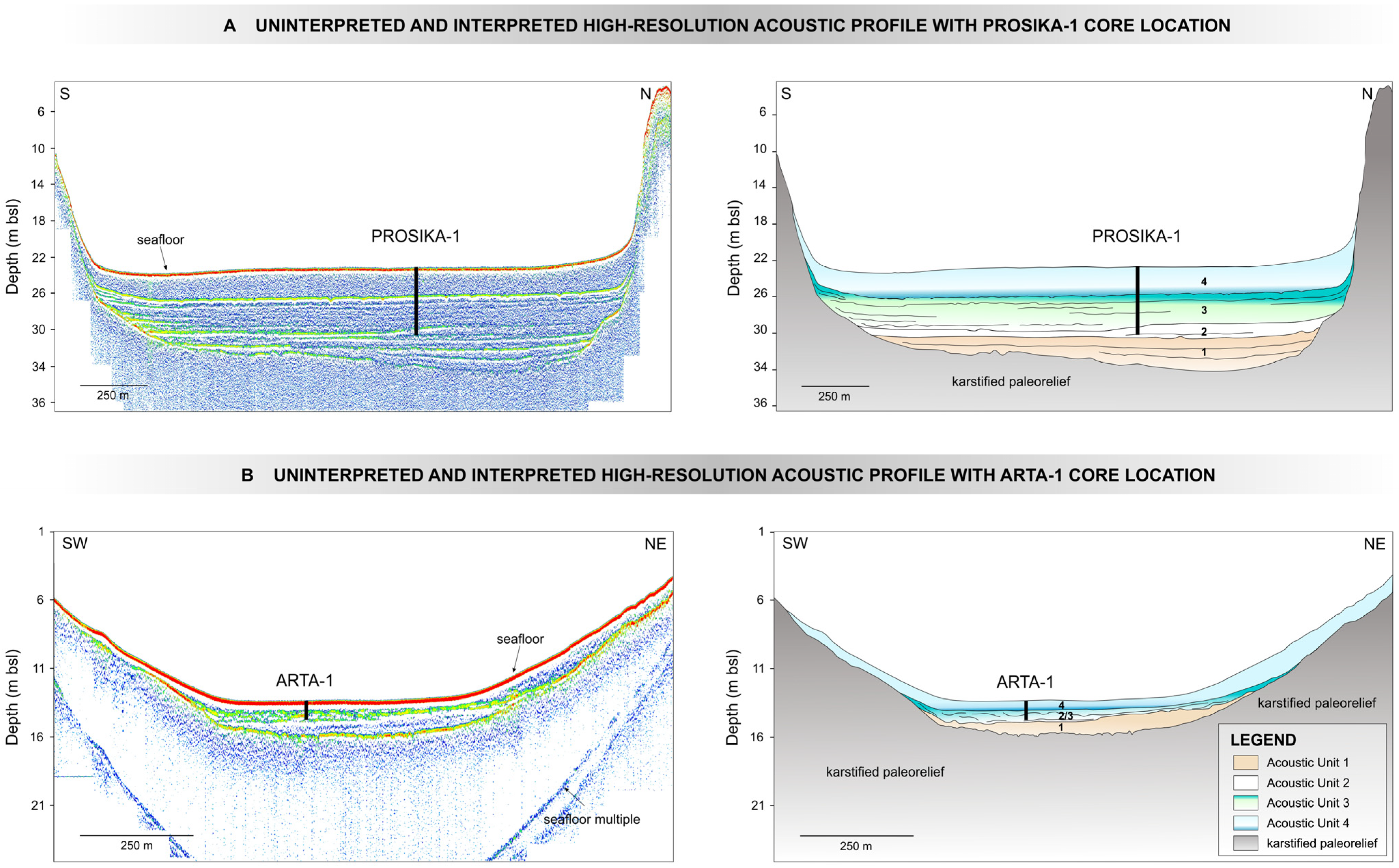
4.1. Acoustic Survey
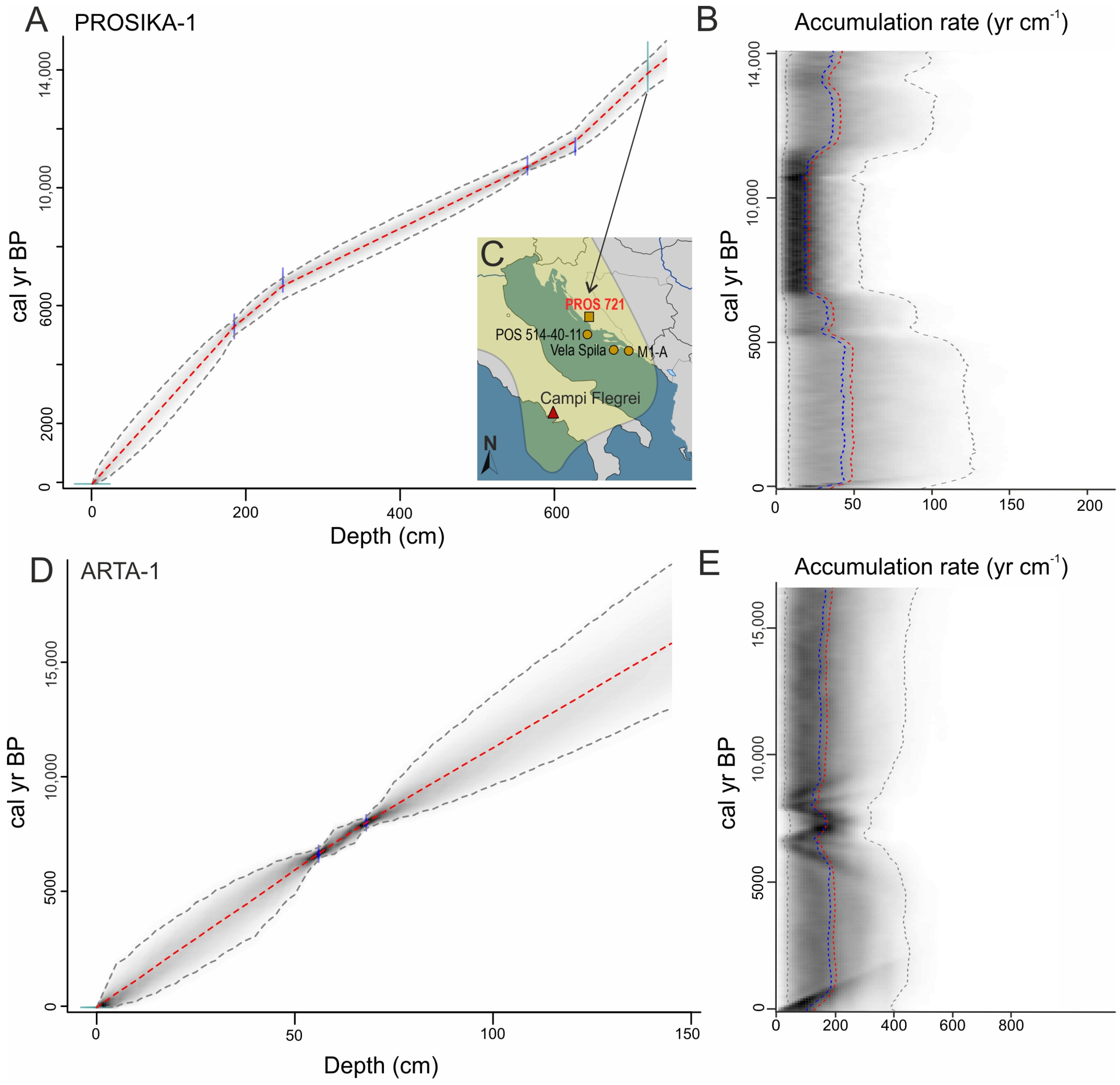
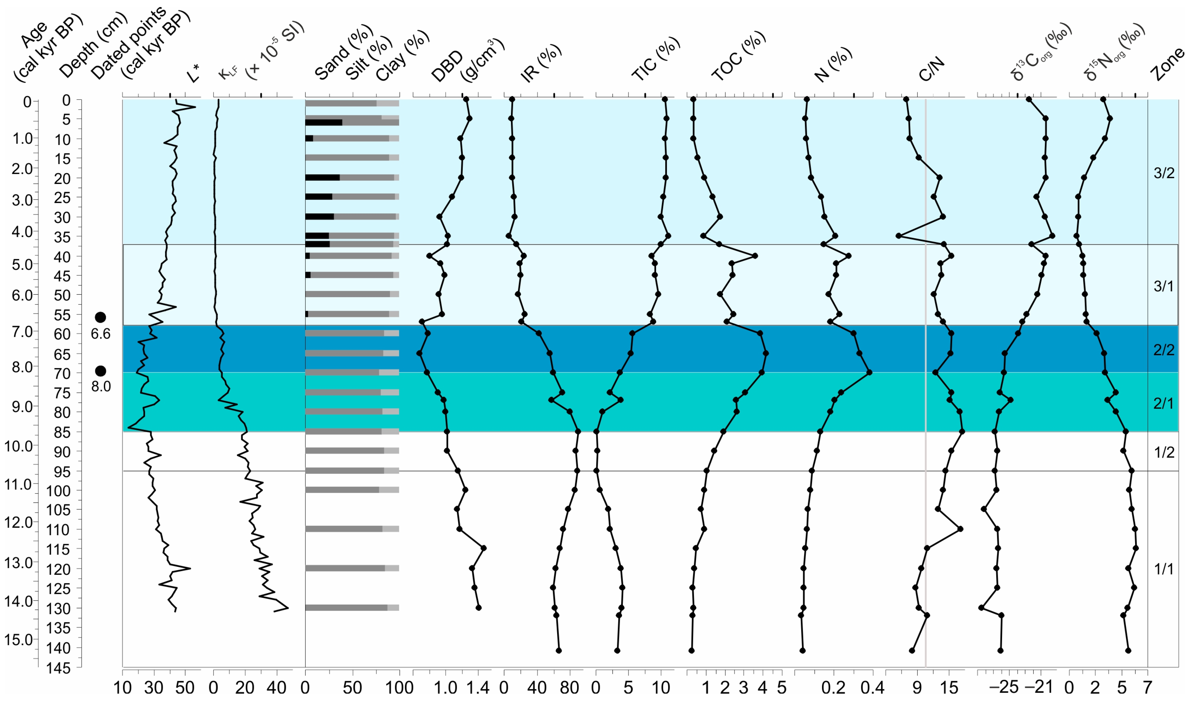
4.2. Sediment Cores Chronologies
4.3. Lithology and Geochemistry
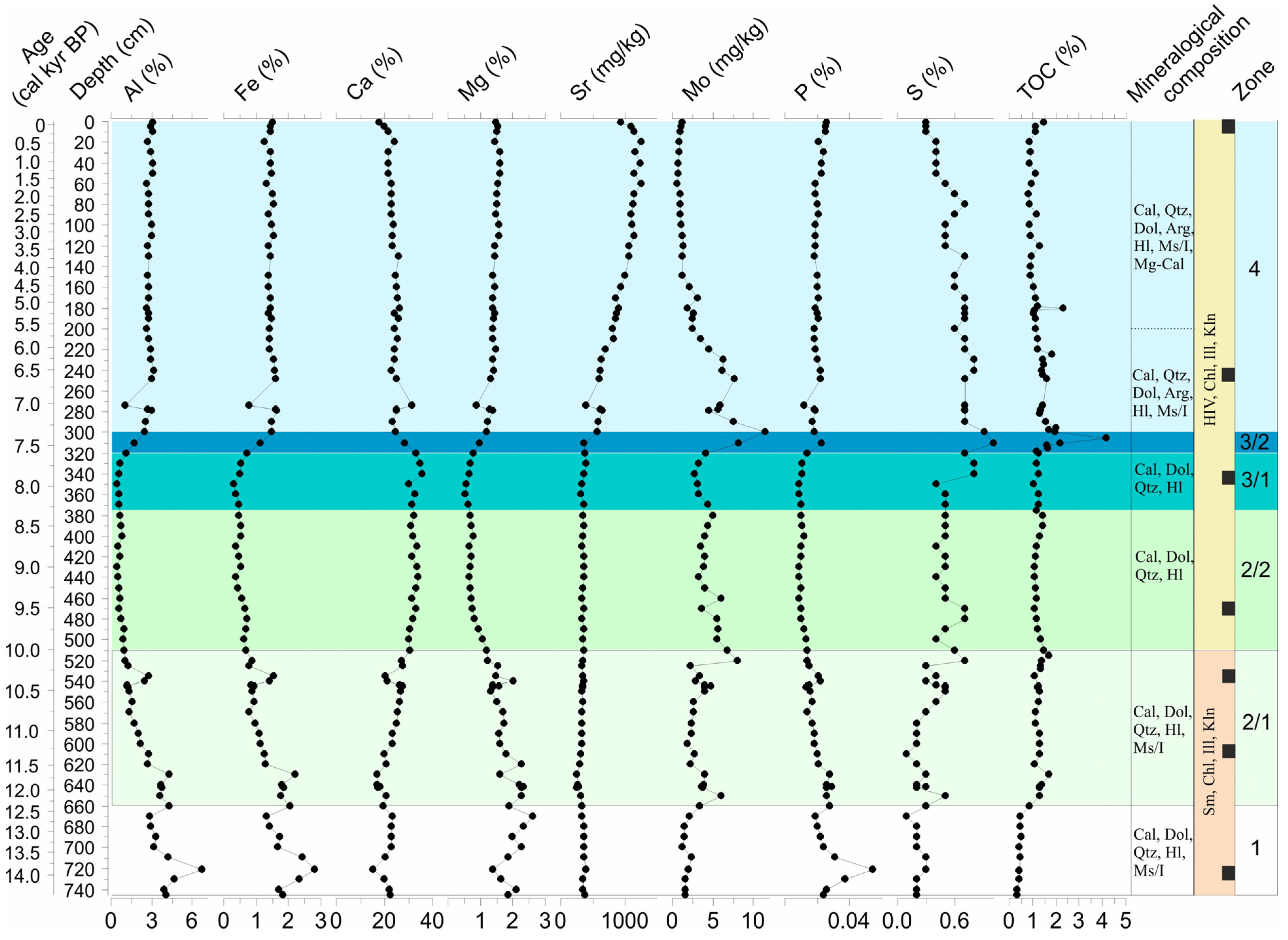
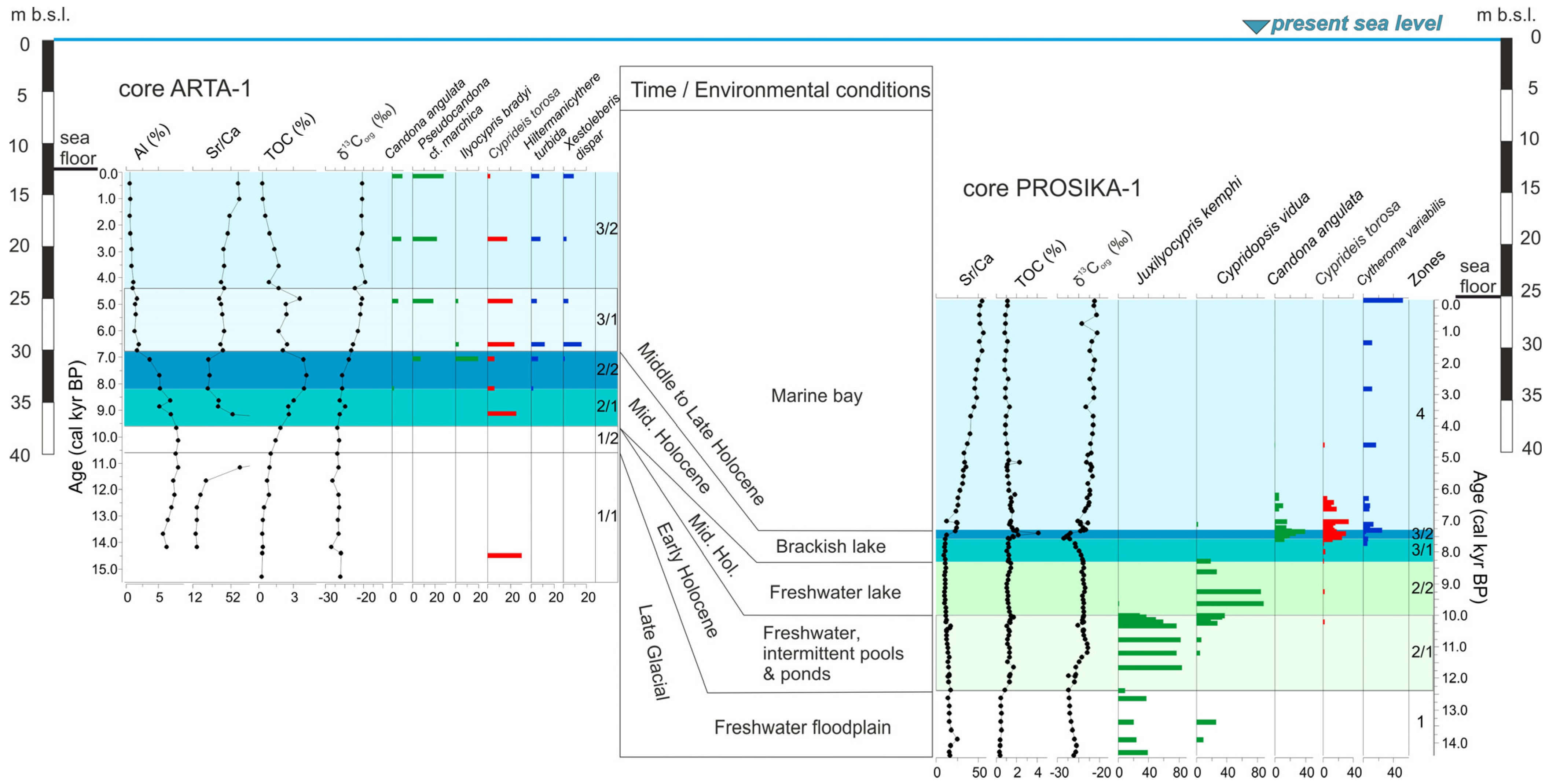
4.3.1. Sediment Core PROSIKA-1
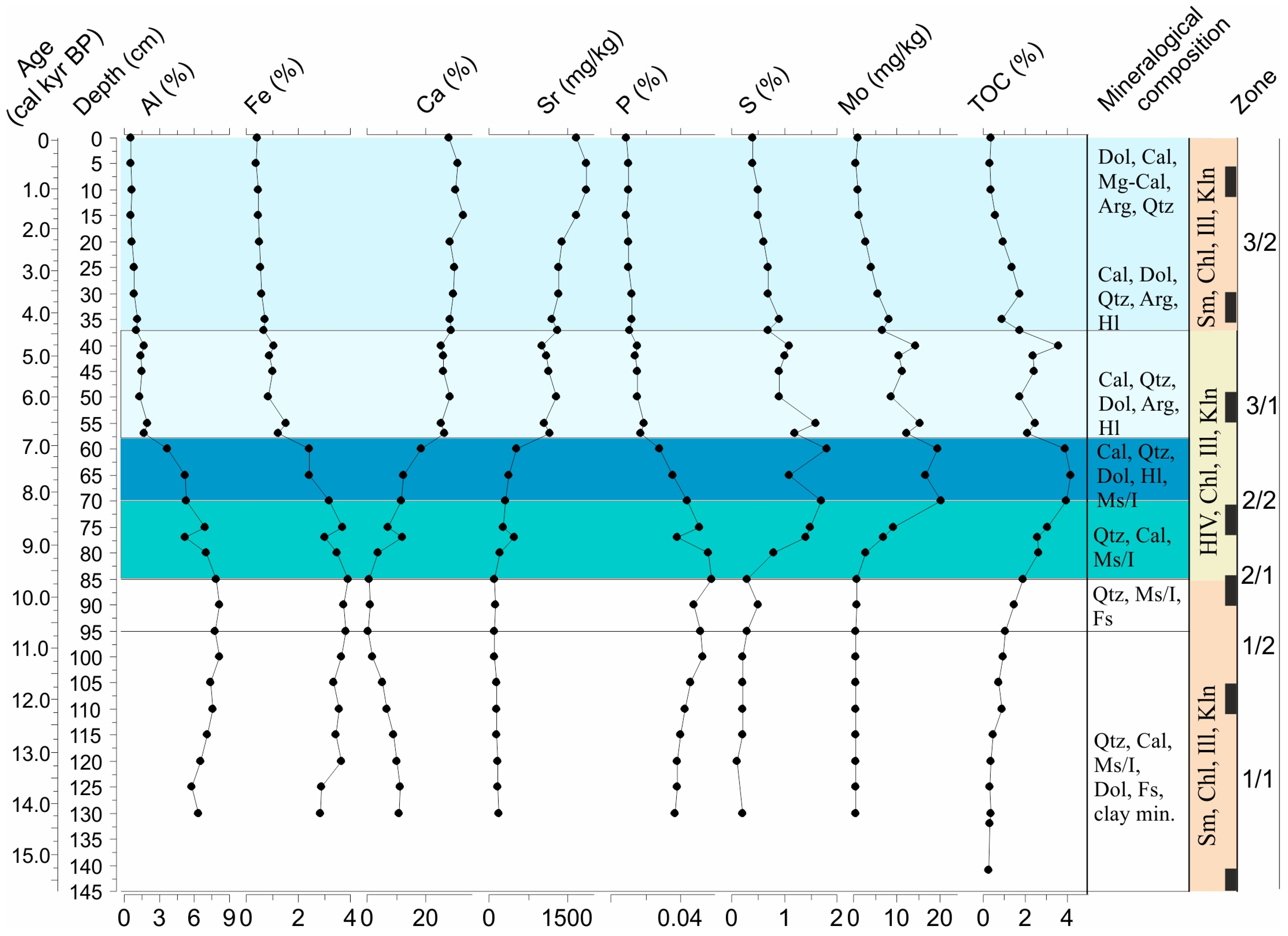
4.3.2. Sediment Core ARTA-1
4.4. Ostracods
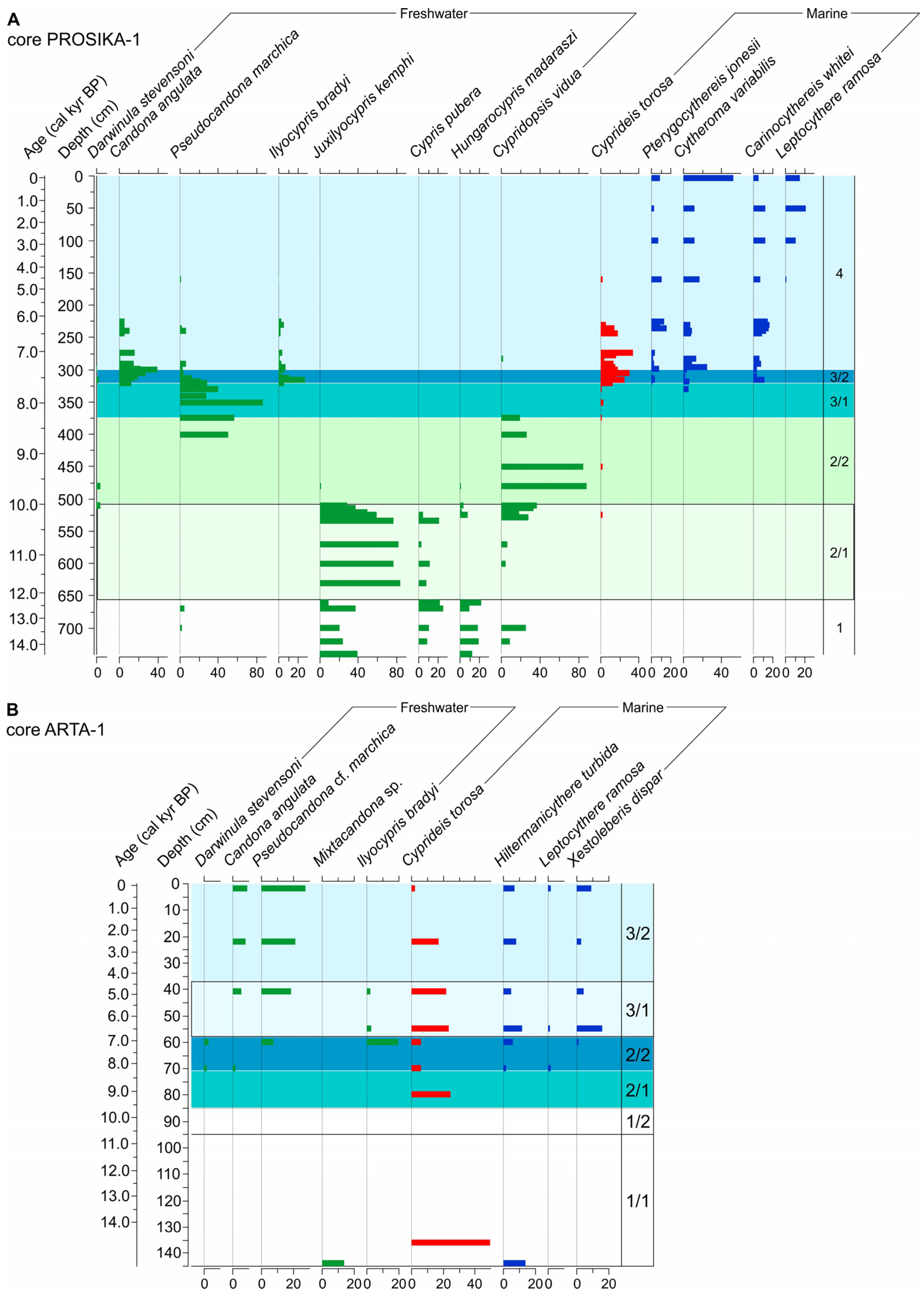
4.4.1. Ostracod Assemblage in Sediment Core PROSIKA-1
4.4.2. Ostracod Assemblage in Sediment Core ARTA-1
5. Discussion
5.1. Geomorphic Setting of Pirovac Bay
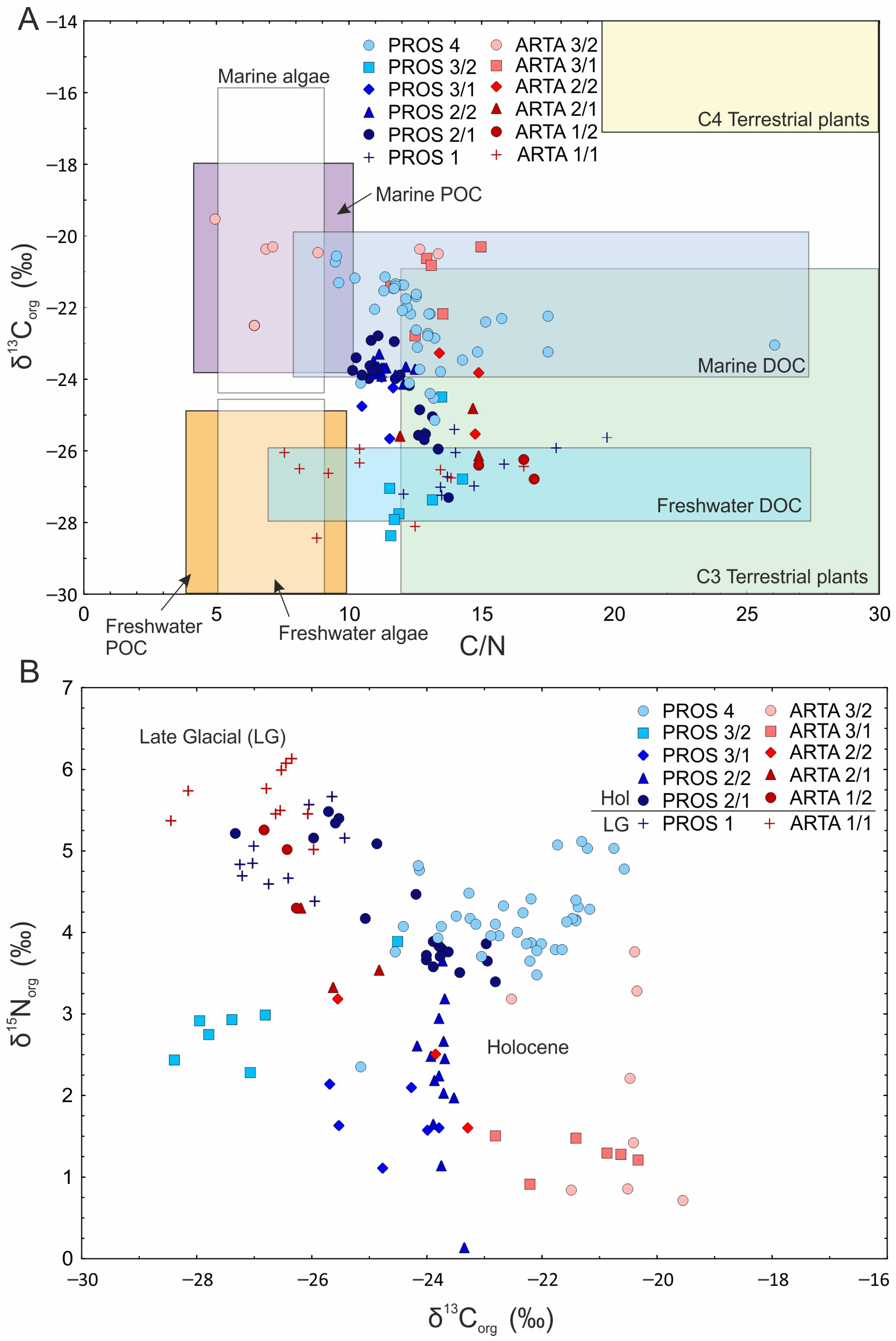
5.2. Late Glacial to Middle Holocene Freshwater Environment (Post-NYT Age–8.3 cal kyr BP)
5.3. Middle Holocene Brackish Lake (8.3–7.3 cal kyr BP)
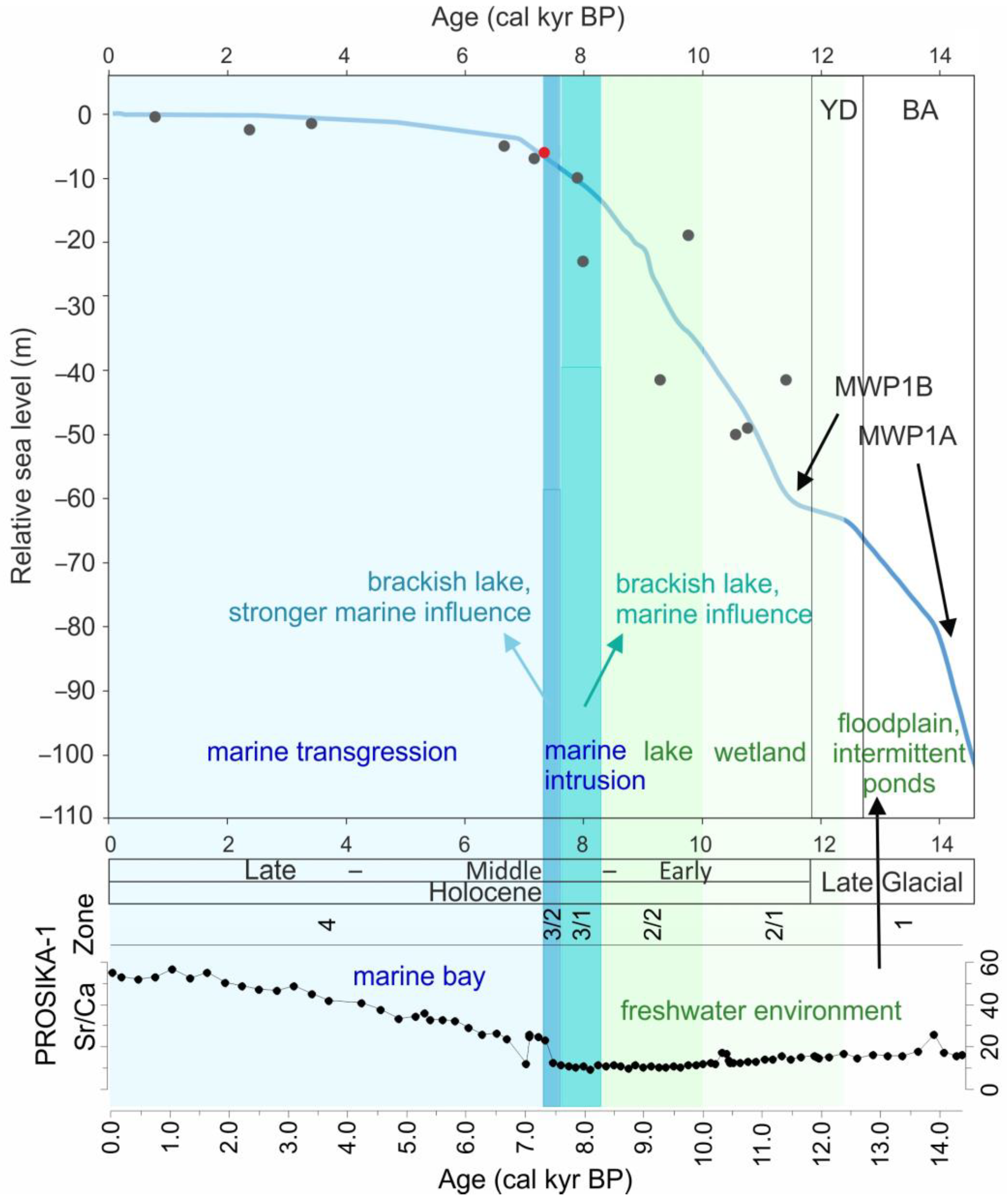

5.4. Middle to Late Holocene Marine Environment (7.3 cal kyr BP to the Present)
6. Conclusions
Supplementary Materials
Author Contributions
Funding
Data Availability Statement
Acknowledgments
Conflicts of Interest
References
- Kelletat, D.H. Dalmatian coasts. In Encyclopedia of Coastal Science; Schwartz, M., Ed.; Springer: Berlin/Heidelberg, Germany; Dordrecht, The Netherlands; New York, NY, USA, 2005; pp. 355–356. [Google Scholar]
- Lewin, J.; Woodward, J. Karst Geomorphology and Environmental Change. In The Physical Geography of the Mediterranean; Woodward, J.C., Ed.; Oxford University Press: Oxford, UK, 2009; pp. 287–317. [Google Scholar]
- Surić, M. Submarine karst of Croatia—Evidence of former sea levels. Acta Carsologica 2002, 31, 89–98. [Google Scholar] [CrossRef]
- Waelbroeck, C.; Labeyrie, L.; Michel, E.; Duplessy, J.C.; Mcmanus, J.F.; Lambeck, K.; Balbon, E.; Labracherie, M. Sea-level and deep water temperature changes derived from benthic foraminifera isotopic records. Quat. Sci. Rev. 2002, 21, 295–305. [Google Scholar] [CrossRef]
- Lambeck, K.; Rouby, H.; Purcell, A.; Sun, Y.; Sambridge, M. Sea level and global ice volumes from the Last Glacial Maximum to the Holocene. Proc. Natl. Acad. Sci. USA 2014, 111, 15296–15303. [Google Scholar] [CrossRef] [PubMed]
- Long, A.J.; Woodroffe, S.A.; Roberts, D.H.; Dawson, S. Isolation basins; sea-level changes and the Holocene history of the Greenland Ice Sheet. Quat. Sci. Rev. 2011, 30, 3748–3768. [Google Scholar] [CrossRef]
- Vidal, L.; Ménot, G.; Joly, C.; Bruneton, H.; Rostek, F.; Çağatay, M.N.; Major, C.; Bard, E. Hydrology in the Sea of Marmara during the last 23 ka: Implications for timing of Black Sea connections and sapropel deposition. Paleoceanography 2010, 25, PA1205. [Google Scholar] [CrossRef]
- Filikci, B.; Eriş, K.K.; Çağatay, N.; Sabuncu, A.; Polonia, A. Late glacial to Holocene water level and climate changes in the Gulf of Gemlik; Sea of Marmara: Evidence from multi-proxy data. Geo-Mar. Lett. 2017, 37, 501–513. [Google Scholar] [CrossRef]
- Ford, D.; Williams, P. Karst Hydrogeology and Geomorphology; John Wiley & Sons Ltd.: Chichester, UK, 2007. [Google Scholar]
- Gale, S.J. The hydraulics of conduit flow in carbonate aquifers. J. Hydrol. 1984, 70, 309–327. [Google Scholar] [CrossRef]
- Terzić, J.; Peh, Z.; Marković, T. Hydrochemical properties of transition zone between fresh groundwater and seawater in karst environment of the Adriatic islands; Croatia. Environ. Earth Sci. 2010, 59, 1629–1642. [Google Scholar] [CrossRef]
- Brkić, Ž.; Kuhta, M.; Hunjak, T.; Larva, O. Regional isotopic signatures of groundwater in Croatia. Water 2020, 12, 1983. [Google Scholar] [CrossRef]
- Zecchin, M.; Ceramicola, S.; Lodolo, E.; Casalbore, D.; Chiocci, F.L. Episodic rapid sea-level rises on the central Mediterranean shelves after the Last Glacial Maximum: A review. Mar. Geol. 2015, 369, 212–223. [Google Scholar] [CrossRef]
- Benjamin, J.; Rovere, A.; Fontana, A.; Furlani, S.; Vacchi, M.; Inglis, R.H.; Galili, E.; Antonioli, F.; Sivan, D.; Miko, S.; et al. Late Quaternary sea-level changes and early human societies in the central and eastern Mediterranean Basin: An interdisciplinary review. Quat. Int. 2017, 449, 29–57. [Google Scholar] [CrossRef]
- Novak, A. Paleocoastline modelling—What a difference a few meters of sediment make? Quat. Int. 2024, 706, 49–59. [Google Scholar] [CrossRef]
- Surić, M.; Juračić, M.; Horvatinčić, N.; Krajcar Bronić, I. Late Pleistocene-Holocene sea-level rise and the pattern of coastal karst inundation: Records from submerged speleothems along the Eastern Adriatic Coast (Croatia). Mar. Geol. 2005, 214, 163–175. [Google Scholar] [CrossRef]
- Lončar, N.; Surić, M.; Bar-Matthews, M.; Faivre, S.; Ayalon, A. Climate variability in southern Croatia from the end of MIS 5 through the last glacial period recorded in stalagmites from Mljet Island caves. Zeitschrift Für Geomorphologie 2022, 63, 245–263. [Google Scholar] [CrossRef]
- Brunović, D.; Miko, S.; Ilijanić, N.; Peh, Z.; Hasan, O.; Kolar, T.; Miko, M.Š.; Razum, I. Holocene foraminiferal and geochemical records in the coastal karst dolines of Cres Island; Croatia. Geol. Croat. 2019, 72, 19–42. [Google Scholar] [CrossRef]
- Brunović, D.; Miko, S.; Hasan, O.; Papatheodorou, G.; Ilijanić, N.; Miserocchi, S.; Correggiari, A.; Geraga, M. Late Pleistocene and Holocene paleoenvironmental reconstruction of a drowned karst isolation basin (Lošinj Channel; NE Adriatic Sea). Palaeogeogr. Palaeoclimatol. Palaeoecol. 2020, 544, 109587. [Google Scholar] [CrossRef]
- Brunović, D.; Hasan, O.; Miko, S.; Georgiou, N.; Geraga, M.; Christodoulou, D.; Dimas, X.; Ilijanić, N.; Papatheodorou, G. High-resolution seismic record of the Quaternary palaeoenvironments along a Dalmatian-type coast (Lošinj Channel; Adriatic Sea). Mar. Geol. 2024, 474, 107325. [Google Scholar] [CrossRef]
- Razum, I.; Miko, S.; Ilijanić, N.; Hasan, O.; Šparica Miko, M.; Brunović, D.; Pawlowsky-Glahn, V. A compositional approach to the reconstruction of geochemical processes involved in the evolution of Holocene marine flooded coastal karst basins (Mljet Island; Croatia). Appl. Geochem. 2020, 116, 104574. [Google Scholar] [CrossRef]
- Razum, I.; Miko, S.; Ilijanić, N.; Petrelli, M.; Röhl, U.; Hasan, O.; Giaccio, B. Holocene tephra record of Lake Veliko jezero, Croatia: Implications for the central Mediterranean tephrostratigraphy and sea level rise. Boreas 2020, 49, 653–673. [Google Scholar] [CrossRef]
- Šolaja, D.; Miko, S.; Brunović, D.; Ilijanić, N.; Hasan, O.; Papatheodorou, G.; Geraga, M.; Durn, T.; Christodoulou, D.; Razum, I. Late Quaternary Evolution of a Submerged Karst Basin Influenced by Active Tectonics (Koločep Bay, Croatia). J. Mar. Sci. Eng. 2022, 10, 881. [Google Scholar] [CrossRef]
- Hasan, O.; Miko, S.; Brunović, D.; Papatheodorou, G.; Christodolou, D.; Ilijanić, N.; Geraga, M. Geomorphology of canyon outlets in Zrmanja River estuary and its effect on the Holocene flooding of semi-enclosed basins (The Novigrad and Karin seas, Eastern Adriatic). Water 2020, 12, 2807. [Google Scholar] [CrossRef]
- Smrkulj, N.; Hasan, O.; Brunović, D.; Miko, S.; Ilijanić, N. Holocene palaeoenvironmental development of Prokljan Lake (Krka River; Croatia): Evolution from a calcareous tufa barrier system to a karst estuary. Mar. Geol. 2024, 476, 107370. [Google Scholar] [CrossRef]
- Ilijanić, N.; Miko, S.; Ivkić Filipović, I.; Hasan, O.; Šparica Miko, M.; Petrinec, B.; Terzić, J.; Marković, T. A Holocene Sedimentary Record and the Impact of Sea-Level Rise in the Karst Lake Velo Blato and the Wetlands on Pag Island (Croatia). Water 2022, 14, 342. [Google Scholar] [CrossRef]
- Ilijanić, N.; Miko, S.; Hasan, O.; Bakrač, K. Holocene environmental record from lake sediments in the Bokanjačko blato karst polje (Dalmatia, Croatia). Quat. Int. 2018, 494, 66–79. [Google Scholar] [CrossRef]
- Kaniewski, D.; Marriner, N.; Cheddadi, R.; Morhange, C.; Vacchi, M.; Rovere, A.; Faivre, S.; Otto, T.; Luce, F.; Carre, M.B.; et al. Coastal submersions in the north-eastern Adriatic during the last 5200 years. Glob. Planet. Change 2021, 204, 103570. [Google Scholar] [CrossRef]
- Ilijanić, N.; Miko, S.; Hasan, O.; Brunović, D.; Šparica Miko, M.; Mesić, S. A Paleoenvironmental Reconstruction of Lake Vrana on the Island of Cres (Croatia) Based on the Geochemistry and Mineralogy of the Late Pleistocene and Holocene Sediments. Quaternary 2024, 7, 47. [Google Scholar] [CrossRef]
- Meyers, P.A.; Teranes, J.L. Sediment organic matter. In Tracking Environmental Change Using Lake Sediments Vol 2: Physical and Geochemical Methods; Last, W.M., Smol, J.P., Eds.; Kluwer Academic Publishers: Dordrecht, The Netherlands, 2001; pp. 239–269. [Google Scholar]
- Tesi, T.; Langone, L.; Giani, M.; Ravaioli, M.; Miserocchi, S. Source; diagenesis; and fluxes of particulate organic carbon along the western Adriatic Sea (Mediterranean Sea). Mar. Geol. 2013, 337, 156–170. [Google Scholar] [CrossRef]
- Pellegrini, C.; Tesi, T.; Schieber, J.; Bohacs, K.M.; Rovere, M.; Asioli, A.; Nogarotto, A.; Trincardi, F. Fate of terrigenous organic carbon in muddy clinothems on continental shelves revealed by stratal geometries: Insight from the Adriatic sedimentary archive. Glob. Planet. Change 2021, 203, 103539. [Google Scholar] [CrossRef]
- Frenzel, P.; Boomer, I. The use of ostracods from marginal marine; brackish waters as bioindicators of modern and Quaternary environmental change. Palaeogeogr. Palaeoclimatol. Palaeoecol. 2005, 225, 68–92. [Google Scholar] [CrossRef]
- Holmes, J.; Sayer, C.D.; Liptrot, E.; Hoare, D.J. Complex controls on ostracod palaeoecology in a shallow coastal brackish-water lake: Implications for palaeosalinity reconstruction. Freshw. Biol. 2010, 55, 2484–2498. [Google Scholar] [CrossRef]
- McCormack, J.; Viehberg, F.; Akdemir, D.; Immenhauser, A.; Kwiecien, O. Ostracods as ecological and isotopic indicators of lake water salinity changes: The Lake Van example. Biogeosciences 2019, 16, 2095–2114. [Google Scholar] [CrossRef]
- Vlahović, I.; Tišljar, J.; Velić, I.; Matičec, D. Evolution of the Adriatic Carbonate Platform: Palaeogeography; main events and depositional dynamics. Palaeogeogr. Palaeoclimatol. Palaeoecol. 2005, 220, 333–360. [Google Scholar] [CrossRef]
- Korbar, T. Orogenic evolution of the External Dinarides in the NE Adriatic region: A model constrained by tectonostratigraphy of Upper Cretaceous to Paleogene carbonates. Earth-Sci. Rev. 2009, 96, 296–312. [Google Scholar] [CrossRef]
- Šparica, M.; Koch, G.; Belak, M.; Miko, S.; Šparica Miko, M.; Viličić, D.; Dolenec, T.; Bergant, S.; Lojen, S.; Vreča, P.; et al. Recent Sediments of Makirina Cove (Northern Dalmatia, Croatia): Their Origin Viewed Through a Multidisciplinary Approach. Geol. Croat. 2010, 58, 21–72. [Google Scholar] [CrossRef]
- Miko, S.; Koch, G.; Mesić, S.; Šparica-Miko, M.; Šparica, M.; Čepelak, R.; Bačani, A.; Vreča, P.; Dolenec, T.; Bergant, S. Anthropogenic influence on trace element geochemistry of healing mud (peloid) from Makirina Cove (Croatia). Environ. Geol. 2008, 55, 517–537. [Google Scholar] [CrossRef]
- Bechor, B.; Sivan, D.; Miko, S.; Hasan, O.; Grisonic, M.; Rossi, I.R.; Lorentzen, B.; Artioli, G.; Ricci, G.; Ivelja, T.; et al. Salt pans as a new archaeological sea-level proxy: A test case from Dalmatia; Croatia. Quat. Sci. Rev. 2020, 250, 106680. [Google Scholar] [CrossRef]
- Mamužić, P. Osnovna Geološka Karta SFRJ 1:100,000, List Šibenik K33-8; Institut za Geološka Istraživanja: Zagreb, Croatia; Savezni geološki Zavod: Beograd, Serbia, 1971. [Google Scholar]
- Mamužić, P. Osnovna Geološka Karta SFRJ 1:100,000, Tumač za list Šibenik K33-8; Institut za Geološka Istraživanja: Zagreb, Croatia, 1966; Savezni Geološki Zavod: Beograd, Serbia, 1975.
- Fritz, F. Postanak i starost Vranskog jezera kod Biograda na moru. Geološki Vjesn. 1984, 37, 231–243. [Google Scholar]
- Rubinić, J.; Katalinić, A. Water regime of Vrana Lake in Dalmatia (Croatia): Changes, risks and problems. Hydrol. Sci. J. 2014, 59, 1908–1924. [Google Scholar] [CrossRef]
- Šiljeg, A.; Lozić, S.; Šiljeg, S. A comparison of interpolation methods on the basis of data obtained from a bathymetric survey of Lake Vrana; Croatia. Hydrol. Earth Syst. Sci. 2015, 19, 3653–3666. [Google Scholar] [CrossRef]
- Šikić, Z.; Pernar, N.; Yerkovich, B.B.; Rogošić, J.; Širac, S. Influence of water levels of Vrana Lake and the Adriatic Sea to the water chemistry of Vrana lake. Acta Adriat. 2013, 54, 199–212. [Google Scholar]
- Bonacci, O. Karst hydrogeology/hydrology of dinaric chain and isles. Environ. Earth Sci. 2015, 74, 37–55. [Google Scholar] [CrossRef]
- Blott, S.J.; Pye, K. Gradistat: A grain size distribution and statistics package for the analysis of unconsolidated sediments. Earth Surf. Process. Landf. 2001, 26, 1237–1248. [Google Scholar] [CrossRef]
- Brindley, G.W.; Brown, G. Crystal Structures of Clay Minerals and Their X-Ray Identification; Mineralogical Society: London, UK, 1980. [Google Scholar]
- Moore, D.M.; Reynolds, R.C. X-Ray Diffraction and the Identification and Analysis of Clay Minerals, 2nd ed.; Oxford University Press: Oxford, UK, 1997. [Google Scholar]
- Bonaduce, G.; Ciampo, G.; Masoli, M. Distribution of Ostracoda in the Adriatic Sea; Pubblicazioni della Stazione Zoologica di Napoli: Napoli, Italy, 1975; Volume 40, p. 304. [Google Scholar]
- Breman, B. The Distribution of Ostracods in the Bottom Sediments of the Adriatic Sea; Krips Repro: Meppel, The Netherlands, 1975; pp. 50–165. [Google Scholar]
- Meisch, C. Freshwater Ostracoda of Western and Central Europe; Spectrum Akademischer Verlag: Heidelberg, Germany, 2000. [Google Scholar]
- Frenzel, P.; Keyser, D.; Viehberg, F.A. An illustrated key and (palaeo)ecological primer for Postglacial to Recent Ostracoda (Crustacea) of the Baltic Sea. Boreas 2010, 39, 567–575. [Google Scholar] [CrossRef]
- Fuhrmann, R. Atlas Quartärer und Rezenter Ostracoden Mitteldeutschlands; Altenburger Naturwissenschaftliche Forschungen: Altenburg, Germany, 2012. [Google Scholar]
- Kempf, E.K. Historical development of nomenclature and taxonomy of Cyprideis torosa (Ostracoda). J. Micropalaeontology 2017, 36, 13–20. [Google Scholar] [CrossRef]
- Heaton, T.J.; Köhler, P.; Butzin, M.; Bard, E.; Reimer, R.W.; Austin, W.E.N.; Bronk Ramsey, C.; Groote, P.M.; Hughen, K.A.; Kromer, B.; et al. Marine20—The Marine Radiocarbon Age Calibration Curve (0–55,000 cal BP). Radiocarbon 2020, 62, 779–820. [Google Scholar] [CrossRef]
- Reimer, P.; Austin, W.; Bard, E.; Bayliss, A.; Blackwell, P.; Bronk Ramsey, C.; Butzin, M.; Cheng, H.; Edwards, R.; Friedrich, M.; et al. The IntCal20 Northern Hemisphere Radiocarbon Age Calibration Curve (0–55 cal kBP). Radiocarbon 2020, 62, 725–757. [Google Scholar] [CrossRef]
- STATISTICA (Data Analysis Software System), Version 7.1, StatSoft, Inc.: Tulsa, OK, USA, 2006.
- Juggins, S. C2 Data Analysis, Version 1.7.7. Newcastle University: Newcastle upon Tyne, UK, 2011.
- Blaauw, M.; Christen, J.A. Flexible paleoclimate age-depth models using an autoregressive gamma process. Bayesian Anal. 2011, 6, 457–474. [Google Scholar] [CrossRef]
- Razum, I.; Ilijanić, N.; Petrelli, M.; Pawlowsky-Glahn, V.; Miko, S.; Moska, P.; Giaccio, B. Statistically coherent approach involving log-ratio transformation of geochemical data enabled tephra correlations of two late Pleistocene tephra from the eastern Adriatic shelf. Quat. Geochronol. 2023, 74, 101416. [Google Scholar] [CrossRef]
- Galli, P.; Giaccio, B.; Messina, P.; Peronace, E.; Amato, V.; Naso, G.; Nomade, S.; Pereira, A.; Piscitelli, S.; Bellanova, J.; et al. Middle to Late Pleistocene activity of the northern Matese fault system (southern Apennines; Italy). Tectonophysics 2017, 699, 61–81. [Google Scholar] [CrossRef]
- Lloyd, J. Combined Foraminiferal and Thecamoebian environmental reconstruction from an isolation basin in NW Scotland: Implications for sea-level studies. J. Foraminifer. Res. 2000, 30, 294–305. [Google Scholar] [CrossRef]
- Razum, I.; Hasan, O.; Brunović, D.; Schulz, H.; Ilijanić, N.; Beg Paklar, G.; Ramisch, A.; Giaccio, B.; Šparica Miko, M.; Monaco, L.; et al. Influence of changing water mass circulation on detrital component and carbon burial of late Pleistocene and Holocene sediments in the eastern-central Mid-Adriatic deep. Mar. Pet. Geol. 2024, 167, 106985. [Google Scholar] [CrossRef]
- Radić, D.; Lugović, B.; Marjanac, L. Neapolitan Yellow Tuff (NYT) from the Pleistocene sediments in Vela Spila on the island of Korčula: A valuable chronostratigraphic marker of the transition from the Palaeolithic to the Mesolithic. Opusc. Archaeol. 2007, 31, 7–26. [Google Scholar]
- Ilijanić, N. Clay Minerals in Lake Sediments along the Eastern Adriatic Coast as Proxies of Environmental Changes during Late Pleistocene and Holocene. Ph.D. Thesis, Faculty of Science, University of Zagreb, Zagreb, Croatia, 2014. (In Croatian). [Google Scholar]
- Lamb, A.L.; Wilson, G.P.; Leng, M.J. A review of coastal palaeoclimate and relative sea-level reconstructions using δ13C and C/N ratios in organic material. Earth-Sci. Rev. 2006, 75, 29–57. [Google Scholar] [CrossRef]
- Dormoy, I.; Peyron, O.; Nebout, N.C.; Goring, S.; Kotthoff, U.; Magny, M.; Pross, J. Climate of the Past Terrestrial climate variability and seasonality changes in the Mediterranean region between 15,000 and 4000 years BP deduced from marine pollen records. Clim. Past 2009, 5, 615–632. [Google Scholar] [CrossRef]
- Hajek-Tadesse, V.; Ilijanić, N.; Miko, S.; Hasan, O. Holocene Ostracoda (Crustacea) from the shallow Lake Vrana (Dalmatia; Croatia) and their paleoenvironmental significance. Quat. Int. 2018, 494, 80–91. [Google Scholar] [CrossRef]
- Hajek–Tadesse, V. Juxilyocypris kempfi; a new species of the genus Juxilocyprus (Ostracoda; Ilyocyprididae) from the Late Pleistocene-Holocene of Eastern Adriatic coast (Croatia). Hist. Biol. 2018, 32, 880–885. [Google Scholar] [CrossRef]
- Taylor, J.; Selby, D.; Lloyd, J.M.; Podrecca, L.; Masterson, A.L.; Sageman, B.B.; Szidat, S. Palaeoenvironmental reconstruction of Loch Duart (NW Scotland, UK) since the Last Glacial Maximum: Implications from a multiproxy approach. J. Quat. Sci. 2023, 39, 6–23. [Google Scholar] [CrossRef]
- Hartman, G.; Bar-Yosef, O.; Brittingham, A.; Grosman, L.; Munro, N.D. Hunted gazelles evidence cooling; but not drying; during the Younger Dryas in the southern Levant. Proc. Natl. Acad. Sci. USA 2016, 113, 3997–4002. [Google Scholar] [CrossRef]
- Durn, G.; Ottner, F.; Slovenec, D. Mineralogical and geochemical indicators of the polygenetic nature of terra rossa in Istria, Croatia. Geoderma 1999, 91, 125–150. [Google Scholar] [CrossRef]
- Rogulj, B.; Marmonier, P.; Lattinger, R.; Danielopol, D. Fine-scale distribution of hypogean Ostracoda in the interstitial habitats of the Rivers Sava and Rhône. Hydrobiologia 1994, 287, 19–28. [Google Scholar] [CrossRef]
- Meyers, P.A. Organic geochemical proxies of paleoceanographic, paleolimnologic, and paleoclimatic processes. Org. Geochem. 1997, 27, 213–250. [Google Scholar] [CrossRef]
- Naele, J.W. Ostracods and palaeosalinity reconstruction. In Ostracoda in the Earth Sciences; De Deckker, P., Volin, J.P., Peypouquet, J.P., Eds.; Elsevier: Amsterdam, The Netherlands, 1988; pp. 125–157. [Google Scholar]
- Rosenfeld, A.; Vesper, B. The variability of the sieve-pore in Recent and Fossil species of Cyprideis torosa (Jones 1850) as an indicator for salinity and paleosalinity. In Aspects of Ecology and Zoogeography of Recent and Fossil Ostracoda; Löffler, H., Danielopol, D.L., Eds.; Junk Publ.: Hague, The Netherlands, 1977; pp. 55–67. [Google Scholar]
- Frenzel, P.; Boomer, I. The use of ostracods from marginal-marine, brackish waters as bioindicators of environmental change and Quaternary palaeoenvironmental analysis e a review. Palaeogeogr. Palaeoclimatol. Palaeoecol. 2005, 225, 68–92. [Google Scholar] [CrossRef]
- Surić, M.; Juračić, M. Late Pleistocene—Holocene Environmental Changes—Records from Submerged Speleothems along the Eastern Adriatic Coast (Croatia). Geol. Croat. 2010, 63, 155–169. [Google Scholar] [CrossRef]
- Novak, A.; Šmuc, A.; Poglajen, S.; Vrabec, M. Linking the high-resolution acoustic and sedimentary facies of a transgressed Late Quaternary alluvial plain (Gulf of Trieste; northern Adriatic). Mar. Geol. 2020, 419, 106061. [Google Scholar] [CrossRef]


| Sample (cm) | Corrected Depth (cm) | Lab. No. | Material | δ13C (‰) | Radiocarbon Age (14C BP) | Calendar Age–Calibrated (cal yr BP) |
|---|---|---|---|---|---|---|
| PROSIKA-1 | ||||||
| 185–186 | 185–186 | Beta-375528 | Marine shell | +2.8 | 5170 ± 40 | 5300 |
| 264–265 | 248–249 | Beta-328263 | Marine shell | +0.3 | 6590 ± 40 | 6900 |
| 279–280 | rejected | Beta-375529 | Marine shell | −0.3 | 6470 ± 30 | / |
| 470–471 | 470–471 | Beta-347640 | Shell | −5.0 | 9550 ± 40 | 9500 |
| 627–628 | 627–628 | Beta-375530 | Wood | −31.1 | 9860 ± 40 | 11,600 |
| 741–754 | 722–735; not used | Beta-343644 | Shell fragments | −9.7 | 11,960 ± 50 | / |
| ARTA-1 | ||||||
| 22–23 | rejected | GdA-4356 | Marine shell | ND | 7818 ± 36 | / |
| 56–57 | 56–57 | GdA-4357 | Marine shell | ND | 6377 ± 29 | 6600 |
| 68–69 | 68–69 | GdA-4358 | Plant | ND | 7712 ± 39 | 8000 |
Disclaimer/Publisher’s Note: The statements, opinions and data contained in all publications are solely those of the individual author(s) and contributor(s) and not of MDPI and/or the editor(s). MDPI and/or the editor(s) disclaim responsibility for any injury to people or property resulting from any ideas, methods, instructions or products referred to in the content. |
© 2025 by the authors. Licensee MDPI, Basel, Switzerland. This article is an open access article distributed under the terms and conditions of the Creative Commons Attribution (CC BY) license (https://creativecommons.org/licenses/by/4.0/).
Share and Cite
Ilijanić, N.; Brunović, D.; Miko, S.; Hajek Tadesse, V.; Hasan, O.; Razum, I.; Šparica Miko, M.; Mesić, S. Late Glacial and Holocene Paleoenvironmental Reconstruction of the Submerged Karst Basin Pirovac Bay on the Eastern Adriatic Coast. J. Mar. Sci. Eng. 2025, 13, 175. https://doi.org/10.3390/jmse13010175
Ilijanić N, Brunović D, Miko S, Hajek Tadesse V, Hasan O, Razum I, Šparica Miko M, Mesić S. Late Glacial and Holocene Paleoenvironmental Reconstruction of the Submerged Karst Basin Pirovac Bay on the Eastern Adriatic Coast. Journal of Marine Science and Engineering. 2025; 13(1):175. https://doi.org/10.3390/jmse13010175
Chicago/Turabian StyleIlijanić, Nikolina, Dea Brunović, Slobodan Miko, Valentina Hajek Tadesse, Ozren Hasan, Ivan Razum, Martina Šparica Miko, and Saša Mesić. 2025. "Late Glacial and Holocene Paleoenvironmental Reconstruction of the Submerged Karst Basin Pirovac Bay on the Eastern Adriatic Coast" Journal of Marine Science and Engineering 13, no. 1: 175. https://doi.org/10.3390/jmse13010175
APA StyleIlijanić, N., Brunović, D., Miko, S., Hajek Tadesse, V., Hasan, O., Razum, I., Šparica Miko, M., & Mesić, S. (2025). Late Glacial and Holocene Paleoenvironmental Reconstruction of the Submerged Karst Basin Pirovac Bay on the Eastern Adriatic Coast. Journal of Marine Science and Engineering, 13(1), 175. https://doi.org/10.3390/jmse13010175