Abstract
The employment of the maritime medium by Southern Levantine societies is examined here through its engagement with coastline facilitation and the building of artificial harbors where natural bays are insufficient or non-existent. The development and availability of technologies and methods are surveyed and analyzed vis-à-vis local choices made to adopt or to reject mediating tools such as jetties, quays, and breakwaters. The article discusses technological and conceptual innovations against the background of long-term practices, essentially in favor of natural features. Despite the early adoption of emerging technologies by such exemplars as Iron Age Atlit, Hellenistic Akko-Ptolemaïs, or Roman Caesarea, the rest of the Southern Levant did not join in, and Caesarea, Akko-Ptolemaïs, and Atlit fell short of maintaining their facilities in the long term. The solution for ships was found instead in natural anchorages and, much more dominantly, in the beaching of smaller vessels and offshore anchoring of larger ones.
1. Introduction
Observed simplistically, the challenging physical features of the southern Levantine coasts should have led towards one of two possible outcomes: local societies could have avoided a complex encounter with the sea, making do with limited connectivity and the basic exploitation of immediately available natural resources; or they could have adopted, and even developed themselves, the sophisticated infrastructure required for enhancing their means to employ the maritime sphere. In effect, in the ancient Southern Levant they mostly did neither, opting, in most places and during most periods, to nurture an intense form of maritime connectivity, this while investing little or nothing in making their coastline more accessible to maritime traffic. This paradoxical success of local societies to engage meaningfully in economic Mediterranean networks while mostly lacking the portals usually imagined as necessary for the process requires an explanation, which is this article’s main task. On a broader level, the discussion should address equally the willingness of Mediterranean networks themselves to accommodate players less developed logistically—the Southern Levant by no means being the only one—for example, by adjusting the size of ships or the means of loading and unloading them. The paradox is, in fact, intensified by the fact that the Southern Levant was perfectly aware of all major technological innovations, mostly to see them adopted only arbitrarily and inconsistently, if not altogether rarely.
The ancient harbor has been the focus of academic research for decades, with significant progress witnessed in the excavation and analysis of particular sites and, through them, in understanding the level and quality of micro-regional connectivity more broadly. Specifically, numerous studies on the harbors of the Israeli coast—comparative and diachronic in nature—were conducted during the 1980s and 1990s [1,2], examining the development of the use of anchorages and the construction of harbor facilities from the Bronze Age to the Middle Ages. The study of harbors and anchorages of all periods has continued since, with a diachronic update appearing recently [3].
No less importantly, the last couple of decades have also seen the theoretical study of harbors and maritime interaction developed to modify long-held views on harbor use and offer a holistic approach to understanding the point of contact between coastal society and the sea [4,5,6]. The long-surviving bias towards the great artificial harbors has gradually been neutralized by growing awareness of the far more basic haunts of coast-skirting and the caboteur. In addition, processual approaches to the development of harbor technology have been balanced by the careful study of how form was made to fit function.
The bias of early maritime research towards big ships and great harbors generated essentially evolutionary paradigms for the development of harbors, highlighting aspects of technological innovation and dramatic change in practice and conception and producing a semblance of constant aspiration of maritime societies to improve the nature of their interaction with the sea. The broad Mediterranean picture matches, in this respect, the story as it has been told for the Southern Levant, which often appears as a precursor for the invention or early adoption of new concepts and technologies. The dating of some of the phenomena relevant to the topic, from maritime-based economies to harbor and shipbuilding technologies, may indeed be on occasion early enough to warrant pioneering titles. Still, the focus on change obscures from sight those ideas that had been considered, perhaps even tried, and then rejected. The dominance and long-term continuity of cabotage-based infrastructure in the Southern Levant throughout antiquity has been discussed elsewhere. However, perhaps differently from other places around the Mediterranean that experienced similar continuity in the long term, this picture in the Southern Levant must be complemented by examining those occasions where the local society did invest in artificial infrastructure and where great harbors came into being.
2. Methods
To investigate the topic holistically, it is essential to identify significant turning points in the coastal development of the Southern Levant, as well as continuous periods or areas that present no such development, and to pitch the two approaches against one another while assuming they had been conscious of each other’s advantages and shortcomings. The article thus investigates three main events of focused harbor construction: Iron Age Atlit, Hellenistic Akko-Ptolemaïs, and Roman Caesarea Maritima (Figure 1).
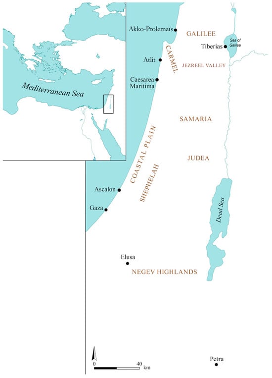
Figure 1.
Map of the Southern Levant and relevant sites (courtesy of S. Haad).
Once the essential data for the construction of each harbor is presented, each site is evaluated for function and durability, aiming to determine its economic importance and longevity and thus, to define the areas and periods less affected by its respective influence.
To base the comparison between the two options—to build or not to build—on conscious, informed decision-making mechanisms, the article proceeds to evaluate the knowledge available to local society for each of the harbors in the decades and centuries following its deterioration based on material and written evidence, while factoring into the discussion the issue of relative sea-level changes, highly relevant for the area during some of the periods surveyed here.
3. Atlit
The Late Bronze Age collapse, although highly destructive to most empires in the Near East and damaging to the societal structures of some local communities, did not appear to disrupt too significantly regular maritime activities in the Southern Levant [7]. This, in turn, had minimal impact on the region’s economy, which relied on connectivity. Trade continued to thrive with imports from Cyprus and Egypt, maintaining a consistent presence. Throughout the 11th and 10th centuries BCE, goods such as pottery, copper, and iron continued flowing into the area [8,9,10]. Hints of exportation are also evident, as seen in examples like the shipment of copper ingots from Neve Yam, originating in Feynan in the Arabah [11]. Notably, the Iron Age did not merely display signs of adaptability and recovery; it showcased technological innovation that did not necessarily evolve gradually but emerged suddenly and in a fully developed state.
Ashlar construction first appeared on the Carmel coast during the later Iron Age I period, corresponding to the 11th century BCE, as evidenced by the substantial land structures observed at Dor [12]. Its prevalence increases notably in the Iron Age II period. During this period, there is a more definitive presence of quays and moles along the coastline. Notably, the complex system of quays and moles at Atlit is attributed to the Iron Age II period, supported by radiocarbon dating of wood found between the stones [13,14]. Additionally, at Tel Dor, a substantial stone wall featuring ashlar stones arranged in headers has been interpreted as a quay from the Late Bronze Age or Iron Age I [15]. Further to the south, near Gaza, at Tel Ridan, another site has been identified, and it contains potentially constructed elements indicative of a stone quay from the late Iron Age II period [16].
The harbor of Atlit was built at the end of the 9th century BCE (Figure 2). It is the earliest example known for the Southern Levant of a full-scale artificial harbor, including not only land-based quays, as had already been seen in Dor, but also jetties and breakwaters, built into the water, and incorporating some of the natural features available at the site, among them a westbound promontory and minute sandstone islets. The harbor consists of two 100 m-long moles, each protruding perpendicularly from a land- or islet-based quay. The resulting rectangular harbor is defended by the promontory from the southwest—the direction from which most of the hydrodynamic energy of the sea is exerted on the shore in this area. The harbor’s opening is on the opposite, northeastern side.
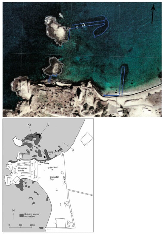
Figure 2.
Satellite image of the Atlit harbor and its plan (indicating excavation areas K1, L, M, M1) [17].
Radiocarbon tests of wooden wedges obtained from the northern mole of the harbor supply the most accurate means of dating, sometime towards the year 800 BCE. Red-slip ware found on land and associated with Phoenician cremation burials, as well as additional finds, support this date for the beginning of settlement at the site [17]. It may thus be assumed that the settlement and the harbor appeared almost simultaneously as part of the emerging trade contacts between the Phoenician realm and the Southern Levant and the extension of its interests towards the Western Mediterranean more broadly. Aspects of trade, colonialism and imperialism related to Iron Age Atlit may be discussed elsewhere. Here, it is essential to dwell on the technology of the harbor’s facilities and its place within the broader context of what experts still define nowadays as the ‘Phoenician’ harbor.
The moles of Atlit took full advantage of the ashlar-based architecture introduced to the Carmel coast area, as we have seen in the previous section, a couple of centuries earlier. They consisted of parallel walls of ashlar headers placed upon rubble fill to offer the construction enhanced stability in the face of hydrodynamic energy. Each mole measured 100–150 m in length and 10 m in width, and both projected from ashlar-built quays, constructed on the southern coast of the harbor and the northernmost sandstone island and measuring some 40 m in length and 4 m in width. The system was complemented by a dam built between the islets, the leveling of necessary parts of the islets, warehouses, and towers used for protection and/or signaling.
The technology employed for the construction of the harbor facilities, as well as the harbor itself as a holistic system, have been described by modern researchers as ‘typically Phoenician’. Multiple parallels exist across the eastern Mediterranean, yet, keeping in mind the elaborate discussion of who the Phoenicians were, the wide temporal and cultural spread of these parallels suggests that referring to all of them as Phoenician may be just as crude a generalization as relating as such to the Archaic Greek alphabet or to the Classical Athenian triremes.
The technology is broadly based on ashlar masonry, employing oblong sandstone blocks usually measuring around 0.5 × 0.5 × 2 m and laid closely alongside each other to produce, initially, coastal quays, and later, when placed in courses in the water, also jetties and breakwaters. One of the earliest representations of this building method in coastal installations is witnessed in Dor, where a massive quay was constructed using such a method already in the Iron I period [18]. About a century later, the establishment of Atlit and its harbor saw the adoption of the technique for the building of the moles described above, with the ashlars now laid in close parallel rows and multiple courses, placed over a foundation layer of pebbles, devised to straighten and stabilize the sandy bottom. Petrographic analysis of these pebbles indicates that they were not local but imported from Syria and Cyprus.
Parallels for the employment of Ashlar masonry for the construction of maritime moles serving as breakwaters exist in numerous other sites across the coastal Levant; not one presents a date earlier than Atlit. Similar concepts, harbor planning, and construction techniques are evident in various other Phoenician harbors located along the Levant, spanning from the Iron Age to the Roman era. These harbors include notable examples in cities such as Tyre, Sidon, Akko, Arwad, Tabbat el-Hammam, the late-4th-century harbor at Amathus in Cyprus, and the Roman quay at Sarepta.
Speculation regarding the timing and location of the pioneering example of Atlit may be attempted rather easily, given the picture of elaborate connectivity available for the Iron Age Southern Levant. However, such speculation does not explain the place of Atlit within the wider context of natural anchorages presented in the previous section. Certainly, we may ascribe the foundation of the city and its harbor to the trade in X or Y or the Phoenician colonization movement more broadly. Given Atlit’s singularity in the coastscape of the Southern Levant, this would be an arbitrary explanation, particularly given two significant facts: the city’s harbor was never renovated or modified after its original construction, unlike most other harbors built using the same technique during the last millennium BCE [19]; and the next artificial harbor to have been built in the Southern Levant—employing, as it were, a technology similar to that seen in Atlit—was constructed in Akko-Ptolemaïs more than five centuries later during the Hellenistic period.
4. Akko-Ptolemaïs
Therefore, the question to be asked is not why Atlit was built but to what extent it was necessary to build. For the maritime needs of the Southern Levant during the Iron Age and the Persian period, though steadily growing, the natural options available along the coast appear to have sufficed for the most part, limited as they appear to scholars today. While elsewhere, particularly in the Northern Levant, the technology introduced by Atlit was soon adopted, the choice in the South was to prefer small anchorages, hauling, and libamento—obviously not for lack of means or knowledge. Gaza, Ascalon, Joppa, Dor, Akko, and a dozen smaller coastal settlements could all initiate and finance the building of such moles. The example they had taken from Atlit may well have been a negative one. This suggestion may be corroborated by the fact that along the densely populated 200 km-long coastline between Achziv and Gaza, there exists no comparable precursor to the pioneering Iron Age experiment observed in Atlit until ashlar-based breakwaters make their appearance in Akko-Ptolemaïs during the Hellenistic period, no earlier than the 3rd century BCE.
Indeed, Persian-era (5th to 4th centuries BCE) artifacts have been unearthed in a dozen locations along this same coastline, including Ascalon, Ashdod, Dor, Abu Hawam, and Megadim. However, though carefully surveyed and studied, none of these sites has yielded to date any evidence of human-made maritime structures, and the next effort to build an artificial harbor occurred only during the reign of the Hellenistic rulers of Egypt, the Ptolemies, who, next to their immense investment in the city of Alexandria and its harbor, also developed the city of Akko-Ptolemaïs and its harbor, and brought to it unprecedented prosperity.
The location chosen for the city’s new harbor was the southeastern side of a headland situated in the northern part of the bay of Akko/Haifa (Figure 3). This place stood in immediate adjacence to the site in which the Hellenistic phase of the city of Akko-Ptolemaïs developed, starting early in the third century BCE. Unlike the situation in Atlit, where the peninsula located next to the site protected the harbor from the southwest, in Akko-Ptolemaïs, the new artificial harbor faced this very direction, exposed to the fierce winter storms that regularly attacked the coastline. The solution devised was technologically identical to the one used in Atlit half a millennium earlier: the construction of an ashlar-built mole of closely placed headers, measuring 12 m in width and some 300 m in length and running almost due east from the tip of the headland.
The evidence shows intense commercial maritime activity during the Hellenistic and Roman periods, in which Akko-Ptolemaïs played a key part [20,21,22]. Unlike the settlement of Atlit, which declined and may have been abandoned at a certain point, Akko-Ptolemaïs remained inhabited continuously and demonstrated resilience and renewed vitality even after reportedly being destroyed. However, the similarities here between the two harbors are more telling: like in Atlit, there is no research indicating later renovation and preservation efforts invested in the coastal facilities of Akko-Ptolemaïs, while the basin continued to function as an anchorage and a haven without interruption. Only in the early Muslim period did the city benefit from a renovated harbor and an additional eastern mole, turning it into an important, albeit short-lived, shipyard in the service of the state.
While we are not sure how soon after their construction the original moles, which had served as a breakwater, ceased to supply protection for ships during challenging weather, Akko-Ptolemaïs may well have faced such a challenge soon after the construction of its harbor since recent research suggests that the relative sea-level in the area rose by nearly two meters during the later Hellenistic period, an issue to which we return below [23]. Such a rapid rise in sea-level would have rendered the moles of Akko less effective, thus downgrading the basin’s functionality from an all-weather, year-round artificial harbor back to a weather-sensitive anchorage. The important part played by Akko-Ptolemaïs in supporting the local economy during the Roman period suggests, once again, that the existence of massive artificial breakwaters was not essential for the prosperity of the coastal Levant, as contemporaries may well have already realized, after the experiences of Atlit and Akko-Ptolemaïs. The traces of these experiences were probably still partly visible in the water at the time when the building of a harbor of a completely different scale began in the Southern Levant towards the end of the 1st century BCE.
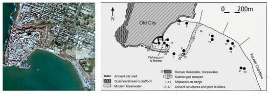
Figure 3.
Aerial photo of the harbor of Akko and its plan [24].
5. Caesarea
After observing the consistent utilization of ashlar-based technology in Atlit and Akko, Sebastos in Caesarea emerges as the next pivotal advancement in artificial harbors within the Southern Levant and across the Mediterranean region more broadly, employing hydraulic concrete for the first time to construct large artificial breakwaters (Figure 4). The location chosen by King Herod for the harbor was not based on any natural features other than a small shallow bay, and its building employed newly acquired knowledge imported from Italy—the usage of hydraulic concrete [25]. Constructed between 22-10/9 BCE, the extensive artificial harbor closely followed Vitruvius’ instructions for the building of concrete harbors, incorporating elements such as the use of pozzolana from the Puteoli region, which Vitruvius recommended as the primary ingredient for effective hydraulic concrete preparation [26].
The Herodian harbor complex consisted of three basins:
- The Outer Basin—The breakwaters delineating and protecting this basin are now submerged. The basin was built into the open sea, using local and imported building materials, mainly to produce hydraulic concrete. The concrete consisted of volcanic ash (pozzolana), crushed limestone, and gravel, poured into floating wooden caissons and then sunk into their intended position. The main piers of the western basin were built of ashlars cut and hewn from local calcareous-cemented sandstone of aeolian origin, laid on their narrow side (headers), and of gigantic concrete blocks, up to 12 m in length. The wide main breakwater was c. 650 m long and built in the shape of the letter L, facing north. The shorter northern breakwater was c. 250 m long, and it was built perpendicularly to the coast, from the land westwards, leaving a narrow entryway into the harbor, facing northwest.
- The Middle Basin—This basin was built on a coastal aeolianite ridge, utilizing a natural bay. In the northeastern and southern parts of this basin, several piers were discovered. Flushing channels were designed to accommodate the hydrodynamic energy at the southern part of the port and convey it towards the mooring pools to create an excess of water that would flow out of the basin. This flow is intended to reduce the penetration of sand into the harbor, thus preventing its clogging.
- The Inner (Eastern) Basin—This basin was based on the lee side of a partly submerged coastal kurkar ridge. After the harbor was out of use, this basin was silted and later populated mostly by Early Islamic buildings [27]. Excavations in this basin revealed a built wharf and mooring facilities for ships [28].
The deterioration of the harbor’s outer basin must have started after the death of Herod’s son, Archelaus, and the provincialization of Judea in 6 CE. The decline was noticeable by the end of the first century, and the inner basin suffered from siltation by the end of the second century [29,30]. By the middle of the third century, the outer breakwaters had lost their integrity, as indicated by excavations conducted in the site underwater and the presence of shipwrecks inside the harbor’s basin itself. By the fourth century, the external, deeper part of the harbor was out of function, and the site as a whole could no longer host ships of larger size [31]. During these long centuries, Caesarea’s port facilities have deteriorated, and there is no evidence—material or written—for any measures taken by the central government to maintain the harbor and mitigate destruction processes.
The words of Procopius of Gaza addressed to the emperor Anastasius in the early 6th century, after the latter had funded some repair work in the harbor, demonstrate how dysfunctional the facility had become [32]: “The port of the city named after Caesar had fallen into bad condition in the course of time and became exposed to the waves, no longer deserving in fact to be titled a port but preserving merely its name from its former fortune. But you [Anastasius] did not ignore the city’s prayers and laments over the ships which, escaping the sea, were wrecked in the harbor itself. […] Thanks to your decision, the city was rejuvenated and receives ships without fear and is provided for its basic requirements.” The repair work funded by Emperor Anastasius was modest, as revealed in archaeological excavations, and mostly consisted of adding a simple rubble breakwater on the submerged northern breakwater [33].
The reasons for the destruction of the Herodian Harbor and the chronology of its decline are still controversial and not fully understood. Numerous hypotheses have been conceived regarding its decline and ultimate collapse. Some of these hypotheses include the suggestion that the destruction was caused by tectonic subsidence [34], by the impact of severe earthquakes [35,36,37], by the effect of unconsolidated sediments under the foundations of the heavy concrete structures [38,39], and even by tsunami waves, which would have slammed the harbor in 115 CE [37], or the 6th century CE [40,41].
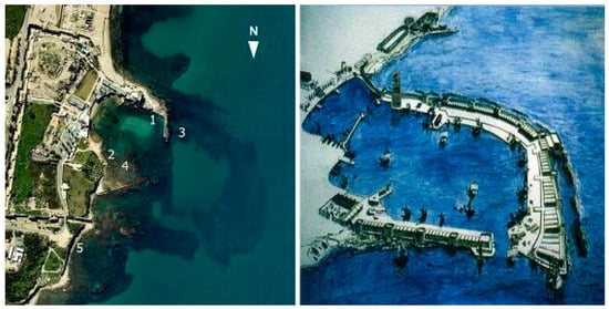
Figure 4.
Left—Aerial photo of the remains of the harbor of Sebastos at Caesarea: (1) Roman dock; (2) Roman dock; (3) collapsed Roman moles, built of concrete; (4) crusader mole; (5) beach-rock deposits. Right—Artistic rendition of the harbor at the time it was built [29].
6. Results and Discussion
While multiple locations across the Mediterranean coastal cities adopted solutions similar to those in the Southern Levant, such as building deep-water sea walls, most of the coastal cities of the Southern Levant chose to keep away from this option. Still, this choice did not reduce their prospects for success, particularly on the commercial-economic front. The emphasis on ‘choice’ is crucial here, assuming that the ancient societies of the area preserved knowledge of their pasts throughout significant stretches of time.
In the long term of historical processes and events, the collective memory of local societies would have preserved knowledge even in the absence of organized written records. Atlit of the Late Iron Age was immersed within the writing cultures of the East, from the Egyptian and Mesopotamian administrations to the Phoenicians and Greeks, and their respective employment of recently invented abjad and alphabet scripts. The fact that Atlit’s harbor does not appear in any known written record despite its modernity corroborates our suggestion that it was short-lived, probably marginal for the imperial powers of the time, and likely a result of local initiative. Still, the society of the coastal Southern Levant, highly maritime and mobile as it was, would have known about its presence for centuries following its abandonment, not only because of the local collective memory but because of the distinct visibility of its remains.
Recent research, based on archaeological evidence and incorporating markers from the Bronze Age onward (including Atlit itself), has shown that the relative sea level along the Southern Levant remained quite stable until the Hellenistic period (Figure 5).

Figure 5.
Computed relative sea level for the coast of Israel with the chronological and vertical uncertainties [23,42].
This would have meant that many of the architectural features built in the harbor of Atlit in the 9th century BCE—and are still protruding above sea level today, some 1.8 m higher—would have been clearly visible to the many travelers of the Via Maris, be it by land or by sea.
For the harbor of Akko-Ptolemaïs, the state of the evidence may be exactly the opposite, but the result remains the same. The written record for this Hellenistic port, built at a time of far heightened literacy under the influence of the Ptolemies, is rich if not too detailed, and it portrayed for the generations that followed the important economic role the harbor had played for a while during the 3rd century BCE before control over the Southern Levant was assumed by the Seleucids. The harbor’s physical visibility, however, would have diminished rapidly as a result of the relative sea level, which started to rise significantly during the Hellenistic period, reaching a significant +1.8 m, where it has remained more or less stable until the present day [23,42]. To be sure, even when sunk in the water, harbors in antiquity were known to the local communities living next to them, as well as to seafarers required to navigate the dangerous areas surrounding them. Much of the defunct architectural features would have been visible inside the water for onlookers from land or boats passing by, and some would have remained protruding above sea level, as is the case in Akko-Ptolemaïs still today, in the Tower of the Flies, for example (Figure 3, feature 22).
Both in the written evidence describing it in detail and in the archaeological remains left behind it—above and under water—the harbor of Caesarea Maritima remained as spectacular and highly visible in its ruins as it had been in its days of glory. Josephus supplied in the 1st century CE a detailed description of its construction and claimed it to have been even bigger than Athens’ Piraeus. Despite its growing dysfunctionality, it continued to be referred to in the written records up until the end of the Crusader period in the late 13th century. Successful or not, Herod’s experiment in building with hydraulic concrete deep into the open sea was widely known, and its memory was preserved for generations and centuries, not only in the local environment of the Southern Levant but throughout the Mediterranean.
The issue of local and regional knowledge is at the heart of this discussion. Harbors using the construction technology of Atlit were built in multiple locations along the coasts of the eastern Mediterranean [43]. However, it took about six centuries for another city south of Tyre—namely Akko-Ptolemaïs—to equip itself with a modern deep-water harbor, this while at least a dozen prosperous candidates—from Achziv to Ascalon and Gaza—would have had the means to acquire such a facility at any given time. Coastal docks were built here and there, to be sure, as in the case of Dor, but generally, no artificial breakwaters are known to have been constructed in order to offer safety for mooring ships and boats. The significance of this absence is accentuated by the coastline’s general lack of natural bays. Herod’s ambitious endeavor in Caesarea, whose monumentality would have perhaps compensated for the scarcity of longer-term docking options along the coasts of the Southern Levant, proved significantly less durable than originally intended. Yet, while more and more harbors took advantage of hydraulic concrete throughout the Roman Mediterranean in their construction or expansion efforts, the Southern Levant, once again, did not join in or even attempt to preserve its chief existing asset.
The reasons for this could have been varied and, again, should be considered to have emanated from an informed position and conscious choices of the local communities rather than from lack of knowledge or resources. The sea-level changes described above could supply part of the explanation, seeing that their result remained evident and visible in the partly submerged coastal constructions of a distant past. However, the timing of those sea-level changes known to us does not align with the chronology of Atlit, Akko-Ptolemaïs, and Caesarea: the first and the second harbors were built during a long millennium of stability; the last was built immediately after a significant rise of 1.8 m, which could have persisted still further, for all that King Herod’s engineers could tell. It is far more likely that the continuous effort to maintain and renovate artificial harbors in the face of severe winter storms and rapid siltation, typical for the region, would have dissuaded potential entrepreneurs from engaging in the effort in the first place [44].
The main alternatives to deep-water artificial basins had been familiar in the eastern Mediterranean since time immemorial, consisting mostly of temporary anchoring and the loading and unloading of ships by smaller vessels such as barges and lighters and, for longer-term stays, including during less hospitable seasons, the hauling of ships and boats onto the beach [45]. While these practices are not easily visible to the archaeologist, they are testified frequently in the written records, which describe, on the one hand, the presence of lighters even on the cargo ships themselves [46] and, on the other hand, the beaching of large fleets of vessels of considerable size [47]. For the ancient Southern Levant, with its highly populated coastline and its sandy beaches, both practices would have been common. When combined, they would have compensated considerably for the lack of deep-water all-year harbors.
In modern research, Atlit, Akko-Ptolemaïs, and Caesarea Maritima produce a distinct technological bias, presenting a picture of constant progress and development of coastal facilities in the Southern Levant and beyond. Maritime activity in the Bronze Age is translated into gradually improving anchorages, with ashlar quays added on the coastline in the early Iron Age and ashlar breakwaters emerging in the sea in the late Iron Age, later to be replaced by hydraulic concrete. While our understanding of these technologies and their date of emergence is now better than ever, and the chronological line presented here is now accurate enough, important questions regarding the benefit of artificial harbors and the adoption of their concept remain not so much unanswered as unasked.
7. Conclusions
Were the harbors of Atlit, Akko-Ptolemaïs and Caesarea essential for the resilience and prosperity of these cities and their hinterland? Were they even contributing significantly to their success? It is, of course, difficult to estimate how the history—economic, strategic, even cultural—of the Southern Levant would have transpired in their absence, but two facts should certainly be underlined in this regard. Firstly, once built, these harbors were not renovated again for long centuries, even when losing their efficacy; yet the cities next to them could still prosper despite their reduced functionality, as was clearly the case in Akko-Ptolemaïs and Caesarea. Secondly, the example they offered neighboring cities and settlements, just as eager for success and emulation, was not adopted, or rather, it served negatively; while clearly owning the resources and being able to harness the now-available knowledge, veteran coastal cities such as Gaza, Ascalon and Joppa, next to many others, did not see fit to follow the early examples of Atlit, Akko-Ptolemaïs, or Caesarea Maritima.
Funding
This research received no external funding.
Institutional Review Board Statement
Not applicable.
Informed Consent Statement
Not applicable.
Data Availability Statement
Data are contained within the article.
Conflicts of Interest
The author declares no conflict of interest.
References
- Raban, A. The Heritage of Ancient Harbour Engineering in Cyprus and the Levant. In Proceedings of the International Symposium ‘Cyprus and the Sea’, Nicosia, Cyprus, 25–26 September 1993; Karageorghis, V., Michaelides, D., Eds.; University of Cyprus: Cyprus, Nicosia; 1995; pp. 139–189. [Google Scholar]
- Galili, E.; Raban, A.; Sharvit, J. Forty Years of Marine Archaeology in Israel. In Proceedings of the Tropis VII. 7th International Symposium on Ship Construction in Antiquity, Lamia, Greece, 28–30 August 1996; Tzalas, H., Ed.; Hellenic lnstitute for the Preservation of Nautical Tradition: Athens, Greece, 2002; pp. 927–961. [Google Scholar]
- Yasur-Landau, A.; Arkin-Shalev, E.; Zajac, P.; Gambash, G. Rethinking the Harbors and Anchorages of the Southern Levant 2,000 BC–600 AD. In Harbors as Objects of Interdisciplinary Research; von Carnap-Bornheim, C., Daim, F., Ettel, P., Warnke, U., Eds.; Verlag des Römisch-Germanischen Centralmuseums: Mainz, Germany, 2018; pp. 73–90. [Google Scholar]
- Preiser-Kapeller, J.; Daim, F. (Eds.) Harbours and Maritime Networks as Complex Adaptive Systems. In RGZM Tagungen Band 23, Interdisziplinäre Forschungen zu den Häfen von der Römischen Kaiserzeit bis zum Mittelalter in Europa 2; Verlag des Römisch-Germanischen Centralmuseums: Mainz, Germany, 2015. [Google Scholar]
- Preiser-Kapeller, J. Harbours and Maritime Mobility: Networks and Entanglements. In RGZM Tagungen Band 23, Interdisziplinäre Forschungen zu den Häfen von der Römischen Kaiserzeit bis zum Mittelalter in Europa 2; Academic Press: Mainz, Germany, 2015; pp. 119–139. [Google Scholar]
- Morhange, C.; Marriner, N.; Carayon, N. Eco-History of Ancient Mediterranean Harbours. In The Inland Seas, towards an Ecohistory of the Mediterranean and the Black Sea; Bekker-Nielsen, T., Gertwagen, R., Eds.; Franz Steiner Verlag: Stuttgart, Germany, 2016; pp. 85–106. [Google Scholar]
- Cline, E. 1177 B.C.: The Year Civilization Collapsed; Princeton University Press: Princeton, NJ, USA, 2015. [Google Scholar]
- Sherratt, S. The Mediterranean Economy: “Globalization” at the End of the Second Millennium B.C.E. In Symbiosis, Symbolism and the Power of the Past: Canaan, Ancient Israel and Their Neighbors from Late Bronze Age through Roman Palaestina, Proceedings of the Centennial Symposium, Jerusalem, Israel, 29–31 May 2000; Dever, W., Gitin, S., Eds.; W.F. Albright Institute of Archaeological Research and American Schools of Oriental Research: Winona Lake, IN, USA, 2003; pp. 37–62. [Google Scholar]
- Gilboa, A.; Sharon, I. An Archaeological Contribution to the Early Iron Age Chronological Debate: Alternative Chronologies for Phoenicia and Their Effects on the Levant, Cyprus, and Greece. Bull. Am. Sch. Orient. Res. 2003, 332, 7–80. [Google Scholar] [CrossRef]
- Waiman-Barak, P.; Gilboa, A.; Goren, Y. A Stratified Sequence of Early Iron Age Egyptian Ceramics at Tel Dor, Israel. Agypt. Levante 2014, 24, 315–342. [Google Scholar] [CrossRef] [PubMed]
- Yahalom-Mack, N.; Galili, E.; Segal, I.; Eliyahu-Behar, A.; Boaretto, E.; Shilstein, S.; Finkelstein, I. New Insights into Levantine Copper Trade: Analysis of Ingots from the Bronze and Iron Ages in Israel. J. Archaeol. Sci. 2014, 45, 159–177. [Google Scholar] [CrossRef]
- Gilboa, A.; Sharon, I. Between the Carmel and the Sea: Tel Dor’s Iron Age Reconsidered. Near East. Archaeol. 2008, 71, 146–170. [Google Scholar] [CrossRef]
- Haggi, A.; Artzy, M. The Harbor of Atlit in Northern Canaanite/Phoenician Context. Near East. Archaeol. 2007, 70, 75–84. [Google Scholar] [CrossRef]
- Haggai, A. Atlit Harbor. Hadashot Arkheologiyot 2005, 117, 1–2. Available online: https://www.jstor.org/stable/26561450?seq=1 (accessed on 1 April 2024).
- Raban, A. Dor-Yam: Maritime and Coastal Installations at Dor in their Geomorphological and Stratigraphical Contexts. In Excavations at Dor, Final Report; Stern, E., Ed.; Areas A and C: Introduction and Stratigraphy; The Institute of Archaeology, Hebrew University: Jerusalem, Israel, 1995; Volume 1, pp. 285–354. Available online: https://ixtheo.de/Record/1589005236 (accessed on 1 April 2024).
- Raban, A.; Galili, E. Recent Maritime Archaeological Research in Israel—A Preliminary Report. Int. J. Naut. Archaeol. Underw. Res. 1985, 14, 329–332. [Google Scholar] [CrossRef]
- Haggi, A. Report on Underwater Excavation at the Phoenician Harbour, Atlit, Israel. Int. J. Naut. Archaeol. 2010, 39, 278–285. [Google Scholar] [CrossRef]
- Arkin-Shalev, E.; Gambash, G.; Yasur-Landau, A. Disheveled Tenacity: The North Bay of Roman and Byzantine Dor. J. Marit. Archaeol. 2019, 14, 205–237. [Google Scholar] [CrossRef]
- Modifications are known to have been introduced to the harbours of Arwad, Sidon, Tyre, Akko-Ptolemaïs, Carthage, Malaga, Motya and Cadiz; see Raban, A. The Phoenician Harbour and “Fishing Village” at Atlit. Eretz-Israel 1996, 25, 498.
- Papyrus Lond. 7.2141. Available online: https://papyri.info/ddbdp/p.lond;7;2141?rows=3&start=207&fl=id,title&fq=collection:ddbdp&fq=(ddbdp_series:p.lond+OR+hgv_series:p.lond+OR+dclp_series:p.lond)&fq=(ddbdp_volume:7+OR+hgv_volume:7+OR+dclp_volume:7)&sort=series+asc,volume+asc,item+asc&p=208&t=261 (accessed on 1 April 2024).
- Lawall, M.L. Two Amphorae from the Swedish Cyprus Expedition in the National Museum of Denmark: Late Archaic through Late Classical Cypriot Trade. In The Transport Amphorae and Trade of Cyprus; Lawall, M., Lund, J., Eds.; Gösta Enbom Monographs 3; Aarhus University Press: Lancaster, Bristol, 2013; pp. 51–60. [Google Scholar]
- Nairn, J.A. The Mimes of Herodas; Clarendon Press: Oxford, UK, 1904; p. 15. Available online: https://archive.org/details/mimesherodas01herogoog (accessed on 1 April 2024).
- Yasur-Landau, A.; Shtienberg, G.; Gambash, G.; Spada, G.; Melini, D.; Arkin-Shalev, E.; Tamberino, A.; Reese, J.; Levy, T.E.; Sivan, D. New Relative Sea-Level (RSL) Indications from Archaeological Constructions in Dor, the Carmel Coast, Israel—From the Middle Bronze Age to the Roman period (~3500–1800 yBP). PLoS ONE 2021, 16, e0251870. [Google Scholar] [CrossRef] [PubMed]
- Galili, E.; Rosen, B.; Zviely, D.; Silberstein, N.; Finkielsztejn, G. The Evolution of Akko Harbor and its Mediterranean Maritime Trade Links. J. Isl. Coast. Archaeol. 2010, 5, 191–211. [Google Scholar] [CrossRef]
- Raban, A. The Harbour of Sebastos (Caesarea Maritima) in its Roman Mediterranean Context. In The Harbour of Sebastos (Caesarea Maritima) in Its Roman Mediterranean Context; Artzy, M., Goodman, B., Gal, Z., Eds.; Archaeopress: Oxford, UK, 2009. [Google Scholar]
- Vitruvius. De Architectura. 5.12. Available online: http://www.perseus.tufts.edu/hopper/text?doc=Perseus%3atext%3a1999.02.0072 (accessed on 1 April 2024).
- Toueg, R. The history of the inner harbour of Caesarea. In Treasures of Caesarea I; Ayalon, E., Izdarehet, A., Eds.; Caesarea Society: Jerusalem, Israel, 2011; pp. 205–216. [Google Scholar]
- Raban, A. Caesarea Maritima 1983–1984. Int. J. Naut. Archaeol. 1985, 14, 155–177. [Google Scholar] [CrossRef]
- Raban, A. Sebastos the Royal Harbour at Caesarea Maritima: A Short-Lived Giant. Int. J. Naut. Archaeol. 1992, 21, 111–124. [Google Scholar] [CrossRef]
- Raban, A. The Inner Harbor Basin of Caesarea: Archaeological Evidence for its Gradual Demise. In Caesarea Maritima: A Retrospective after Two Millenia. Documenta et Monumenta Orientis Antiqui 21; Raban, A., Holum, K.G., Eds.; Brill: Leiden, The Netherlands; New York, NY, USA; Köln, Germany, 1996; pp. 628–666. [Google Scholar]
- Hohlfelder, R. The Changing Fortunes of Caesarea’s Harbours in the Roman Period. In Caesarea Papers I; Vann, R.L., Ed.; Journal of Roman Archaeology: Ann Arbor, MI, USA, 1992; pp. 75–78. [Google Scholar]
- de Gaza, P.; de Cesaree, P. Panegyriques de l’empereur Anastase Ier; Chauvot, A., Ed.; Habelt: Bonn, Germany, 1986. [Google Scholar]
- Hohlfelder, R. Procopius, De Aedificiis 1.11.18.20: Caesarea Maritima and the Building of Harbours in Late Antiquity. In Mediterranean Cities: Historical Perspectives; Malkin, I., Hohlfelder, R.L., Eds.; Routledge: Abingdon, UK; Oxon, UK; New York, NY, USA, 1988; pp. 54–62. [Google Scholar]
- Neev, D.; Emery, K.O. Three Oscillatory Tectonic Movements at Caesarea: One Byzantine and Two Post Byzantine; Report GSI/3/90; Ministry of Energy and Infrastructure, Geological Survey of Israel: Jerusalem, Israel, 1991; pp. 1–25.
- Mart, Y. Caesarea Maritima: Unique Evidence for Earthquake Patterns and Sea Level Fluctuations in the Late Holocene. In Proceedings of the International Symposium Caesarea Maritima—Retrospective after Two Millennia, Leiden, The Netherlands, 3–11 January 1995; Raban, A., Holum, G., Eds.; The University of Chicago Press: Chicago, IL, USA, 1996; pp. 23–25. [Google Scholar]
- Mart, Y. Destructive Earthquakes in Historic Times on the Continental Shelf off Caesarea; RIMS Report 23; Recanati Institute for Maritime Studies: Haifa, Israel, 1996; pp. 7–10. [Google Scholar]
- Reinhardt, E.; Goodman, B.N.; Boyce, J.; Lopez, G.; Hengstum van, P.; Rink, W.J.; Mart, Y.; Raban, A. The Tsunami of 13 December A.D. 115 and the Destruction of Herod the Great’s Harbor at Caesarea Maritima, Israel. Geology 2006, 34, 1061–1064. [Google Scholar]
- Galili, E.; Sharvit, J. Ancient Coastal Installations and the Tectonic Stability of the Israeli Coast in Historical Times. In Coastal Tectonics; Stewart, I.S., Vita-Finzi, C., Eds.; Geological Society: London, UK, 1998; pp. 147–163. [Google Scholar]
- Galili, E. Historical Sea Level Changes and Seafaring Along the Southeastern Mediterranean Coast. In Proceedings of “Cities on the Sea—Past and Present”: 1st International Symposium on Harbours City Ports and Coastal Topography, Haifa, 1986; Raban, A., Ed.; BAR International Series; BAR International: Oxford, UK, 1986; pp. 69–73. [Google Scholar]
- Dey, H.W.; Goodman-Tchernov, B.; Sharvit, J. Archaeological evidence for the tsunami of January 18, 749 Islamic: A chapter in the history of Early Caesarea, Qaysariyah (Caesarea Maritima). J. Rom. Archaeol. 2014, 27, 357–373. [Google Scholar] [CrossRef]
- Goodman-Tchernov, B.N.; Austin, J.A., Jr. Deterioration of Israel’s Caesarea Maritima’s ancient harbor linked to repeated tsunami events identified in geophysical mapping of offshore stratigraphy. J. Archaeol. Sci. Rep. 2015, 3, 444–454. [Google Scholar] [CrossRef]
- Yasur-Landau, A.; Tamberino, A.; Arkin-Shalev, E.; Nickelsberg, R.; Runjajić, M.; Shtienberg, G.; Gambash, G.; Shahack-Gross, R.; Levy, T. Sea-Level Changes and the Location of the ‘Missing’ Hellenistic and Roman Harbours at Tel Dor, Israel. Int. J. Naut. Archaeol. 2024, 53, 1–20. [Google Scholar] [CrossRef]
- Mauro, C.; Gambash, G. The Earliest Limenes Kleistoi: A Comparison between Archaeological-Geological Data and the Periplus of Pseudo-Skylax. Rev. Des Études Anciennes 2020, 122, 55–84. [Google Scholar] [CrossRef]
- Galili, E.; Salamon, A.; Gambash, G.; Zviely, D. Archaeological and Natural Indicators of Sea-Level and Coastal Change: The Case of the Roman Harbor of Caesarea. Geosciences 2021, 11, 1–26. [Google Scholar]
- Votruba, G.F. Did Vessels Beach in the Ancient Mediterranean? An Assessment of the Textual and Visual Evidence. Mar. Mirror 2017, 103, 7–29. [Google Scholar] [CrossRef]
- Isidore of Seville, Etymologiarum sive Originum Isidori Hispalensis, 19.1.19: A Barge (barca) Is the Vessel That Carries All the Freight of a Ship to Shore. On the Open Seas the Ship Carries This Boat in Its Hold Because of the High Waves, but Whenever It Is near to Port, the Barge Repays to the Ship the Service It Accepted At Sea. Available online: https://penelope.uchicago.edu/Thayer/L/Roman/Texts/Isidore/19*.html (accessed on 1 April 2024).
- Herodotus, The Histories, 7.59.2–3: “All the Ships Had Now Arrived in Doriscus, and the Captains at Xerxes’ Command Brought Them to the Beach […]; to This Beach They Brought in Their Ships and Hauled Them Up for Rest”. Available online: http://www.perseus.tufts.edu/hopper/text?doc=Perseus%3atext%3a1999.01.0125 (accessed on 1 April 2024).
Disclaimer/Publisher’s Note: The statements, opinions and data contained in all publications are solely those of the individual author(s) and contributor(s) and not of MDPI and/or the editor(s). MDPI and/or the editor(s) disclaim responsibility for any injury to people or property resulting from any ideas, methods, instructions or products referred to in the content. |
© 2024 by the author. Licensee MDPI, Basel, Switzerland. This article is an open access article distributed under the terms and conditions of the Creative Commons Attribution (CC BY) license (https://creativecommons.org/licenses/by/4.0/).