
Preservation of Transgressive System Tract Geomorphic Elements during the Holocene Sea Level Rise in the South-Eastern Sicilian Tyrrhenian Margin


Abstract
:1. Introduction
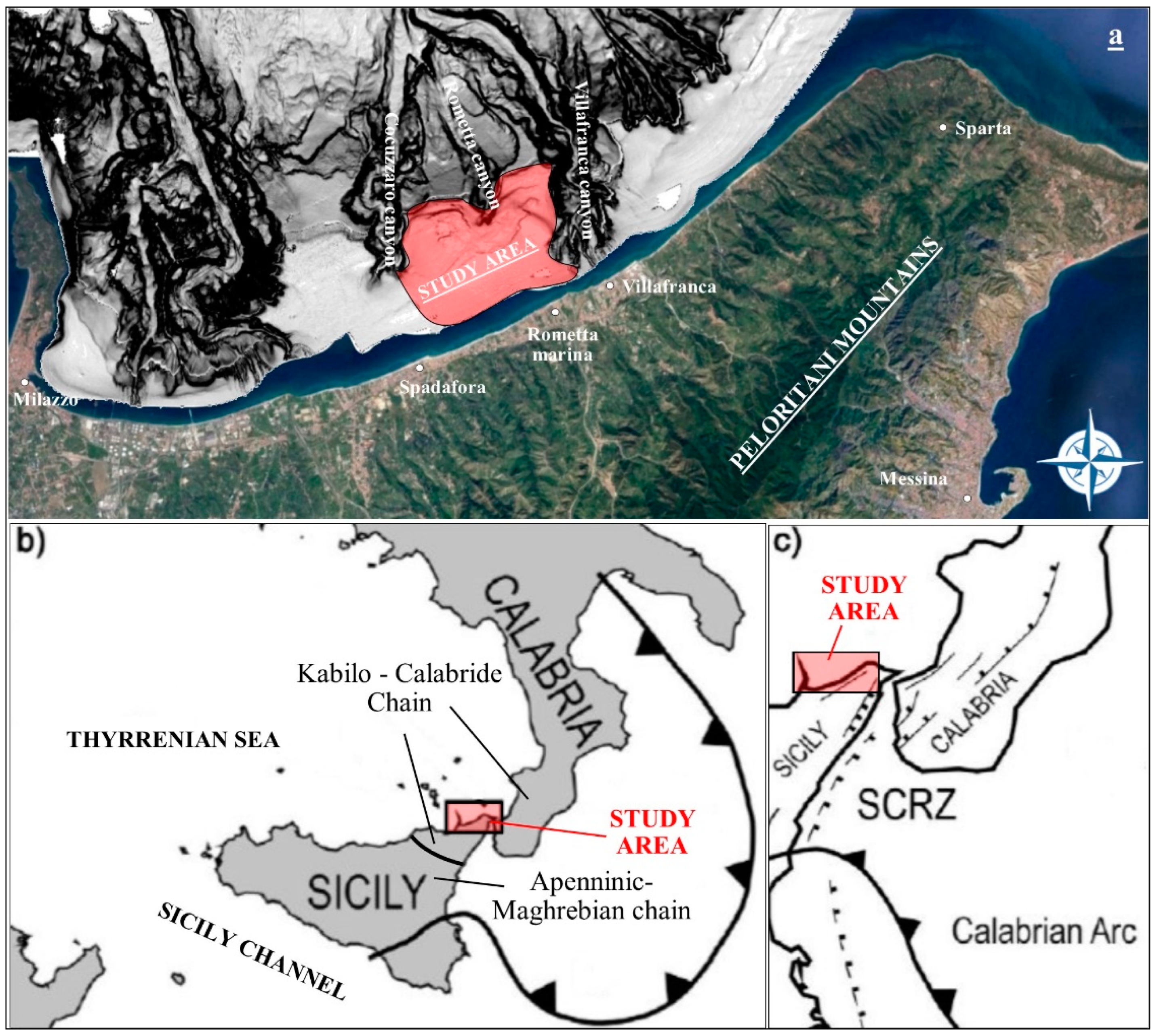
2. Geological Setting
3. Materials and Methods
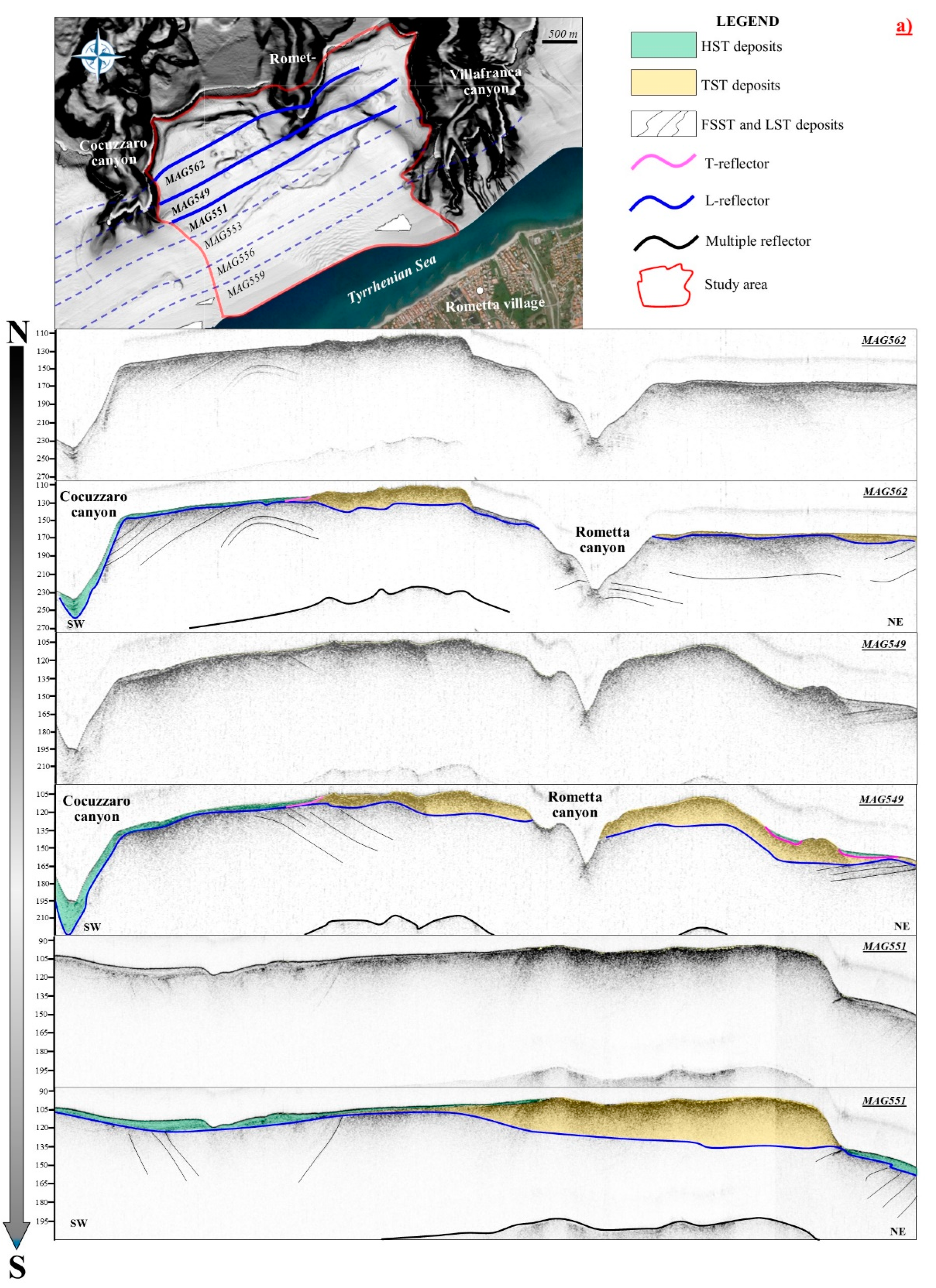
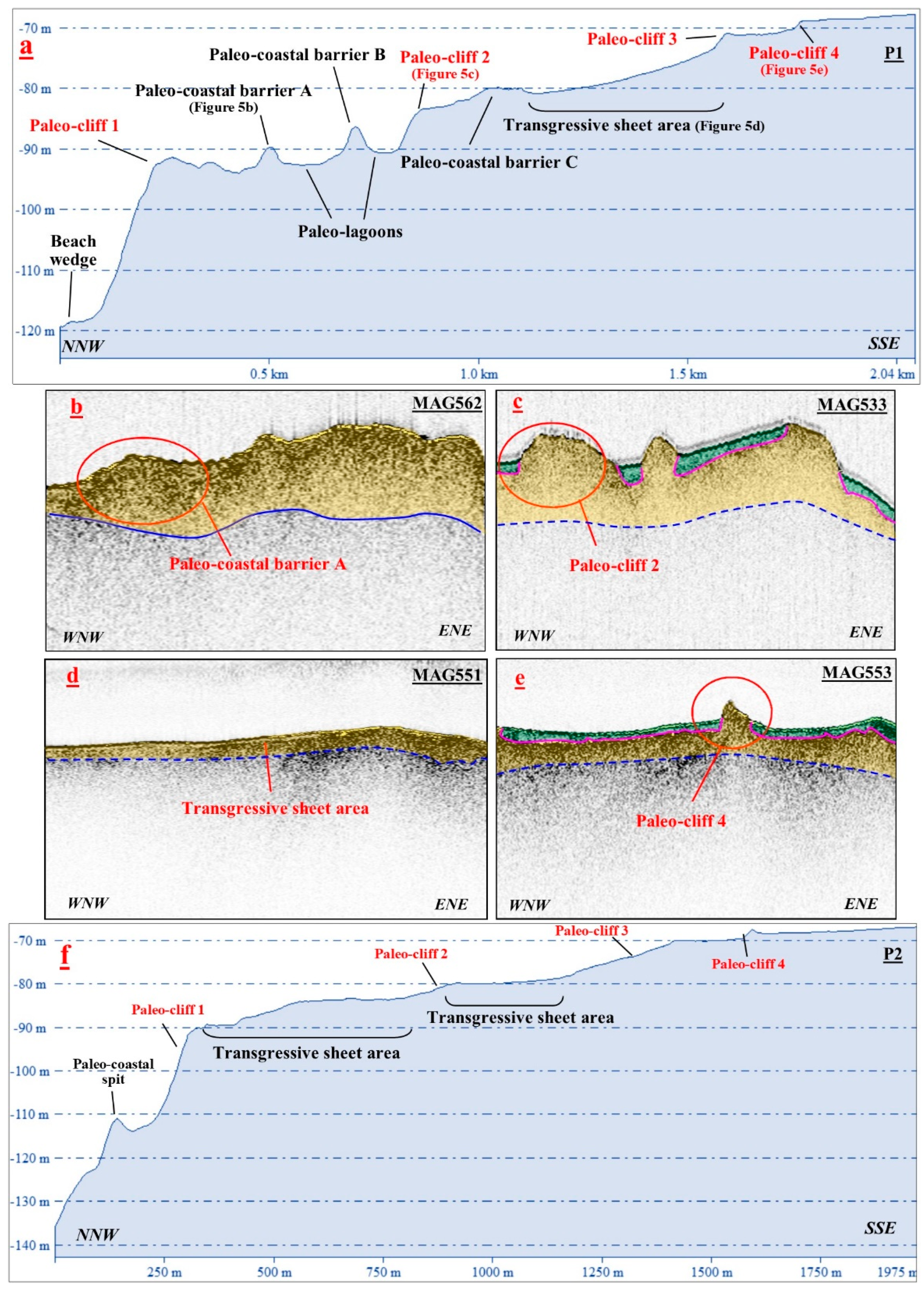
4. Seismic-Stratigraphic Analysis
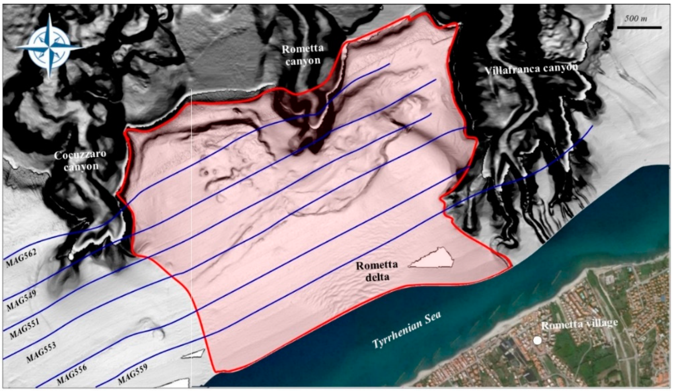
5. Morpho-Bathymetric Analysis
5.1. Western Sector
5.2. Eastern Sector
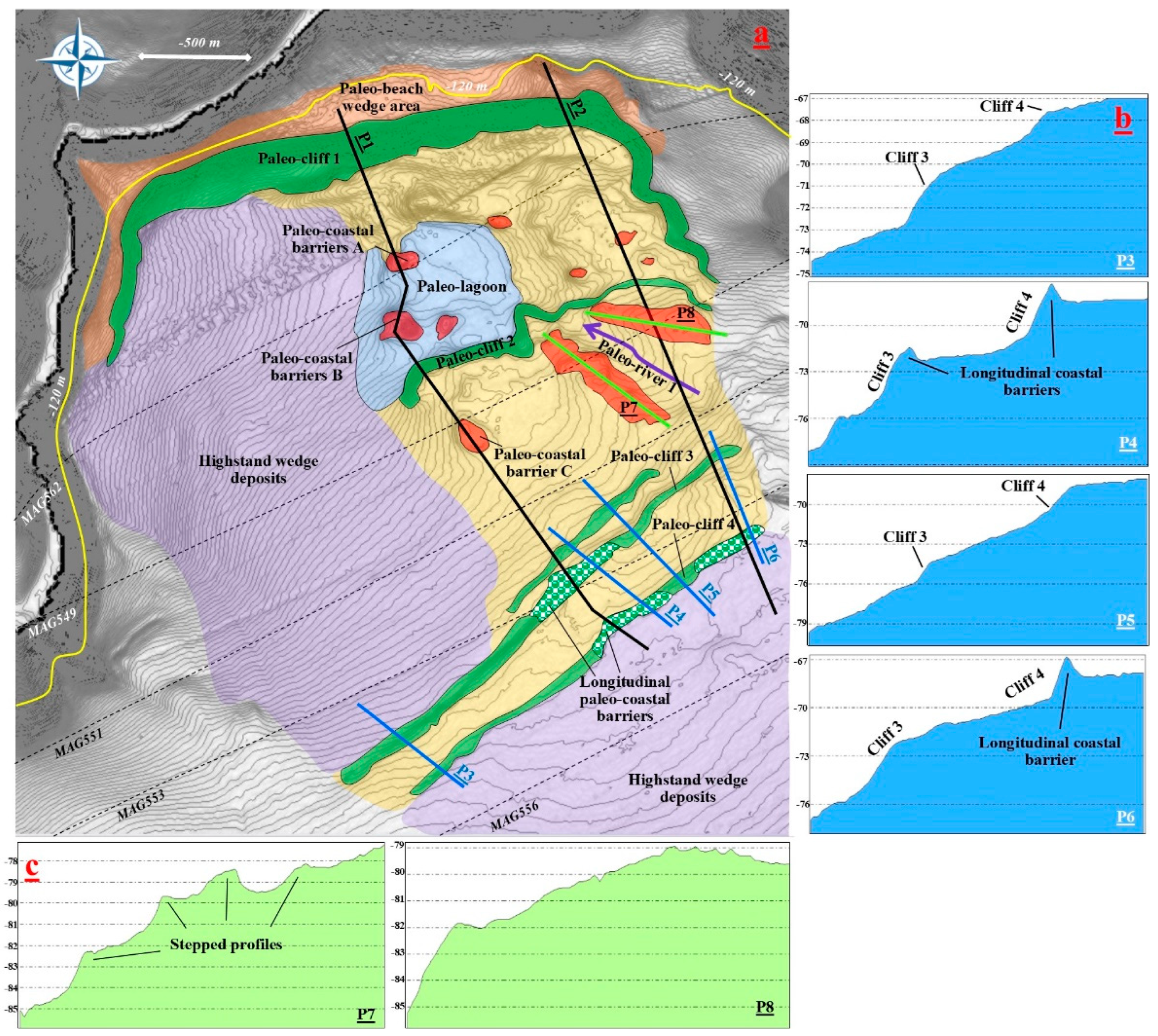
6. Discussion
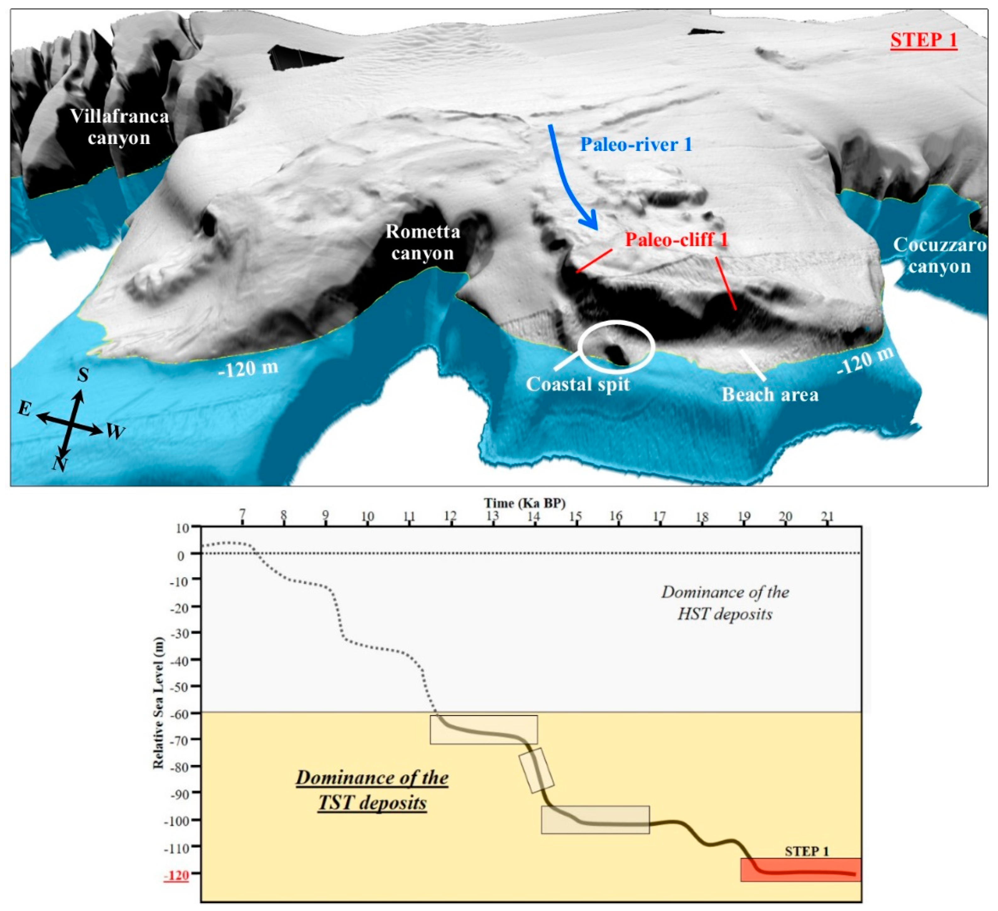
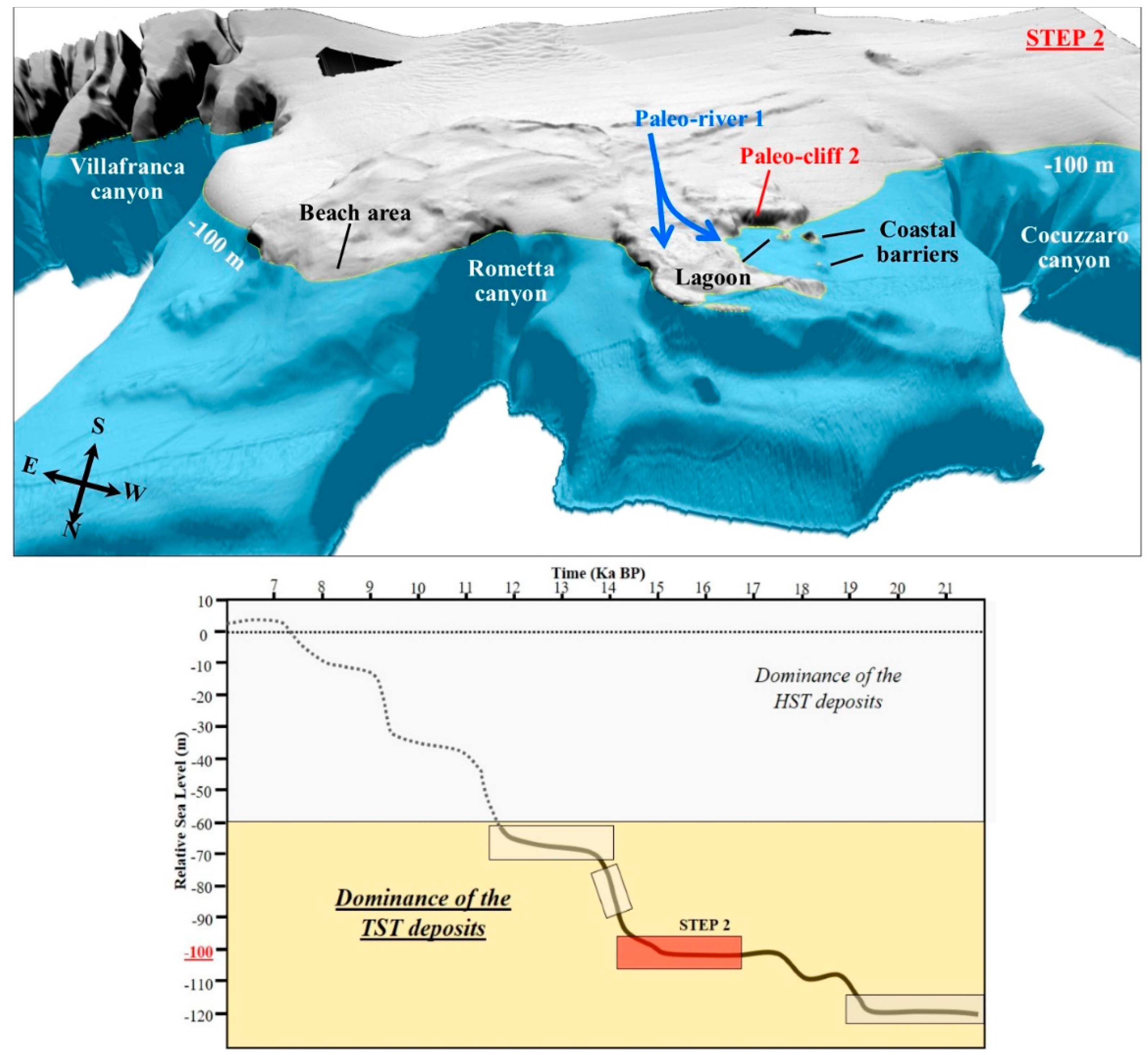
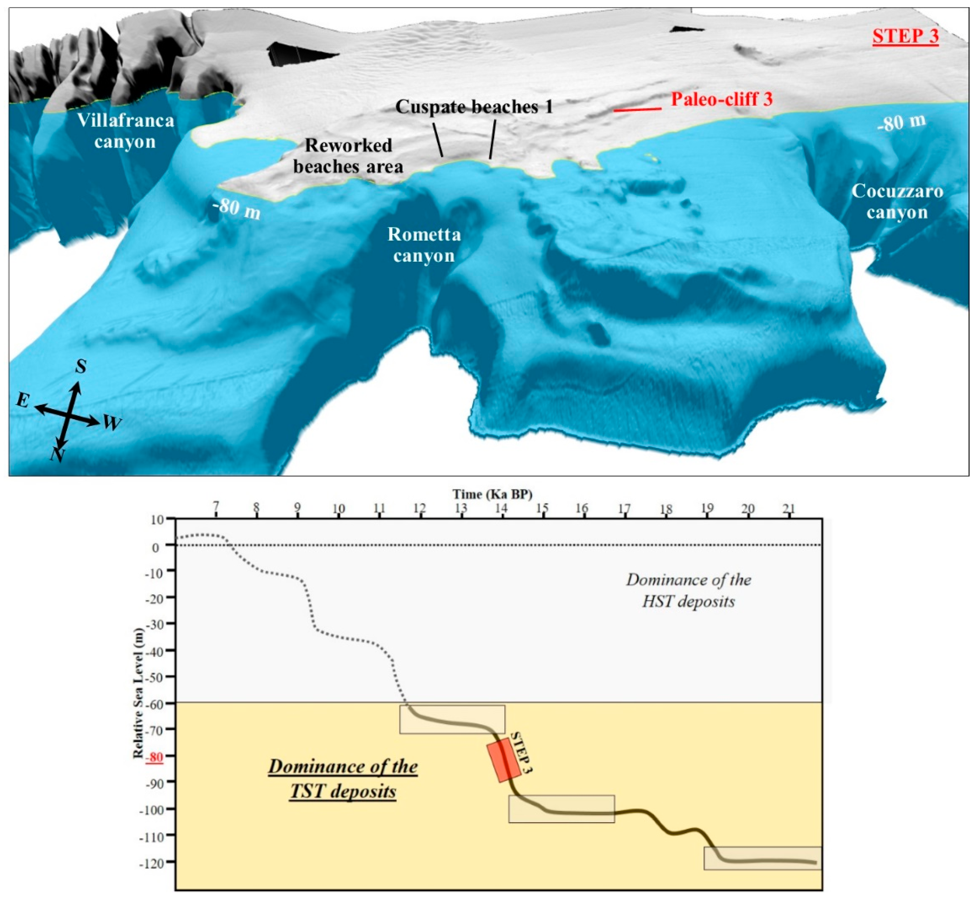
6.1. Last Transgressive Stage Reconstruction
6.1.1. Sea Level −120 m
6.1.2. Sea Level −100 m
6.1.3. Sea Level −80 m
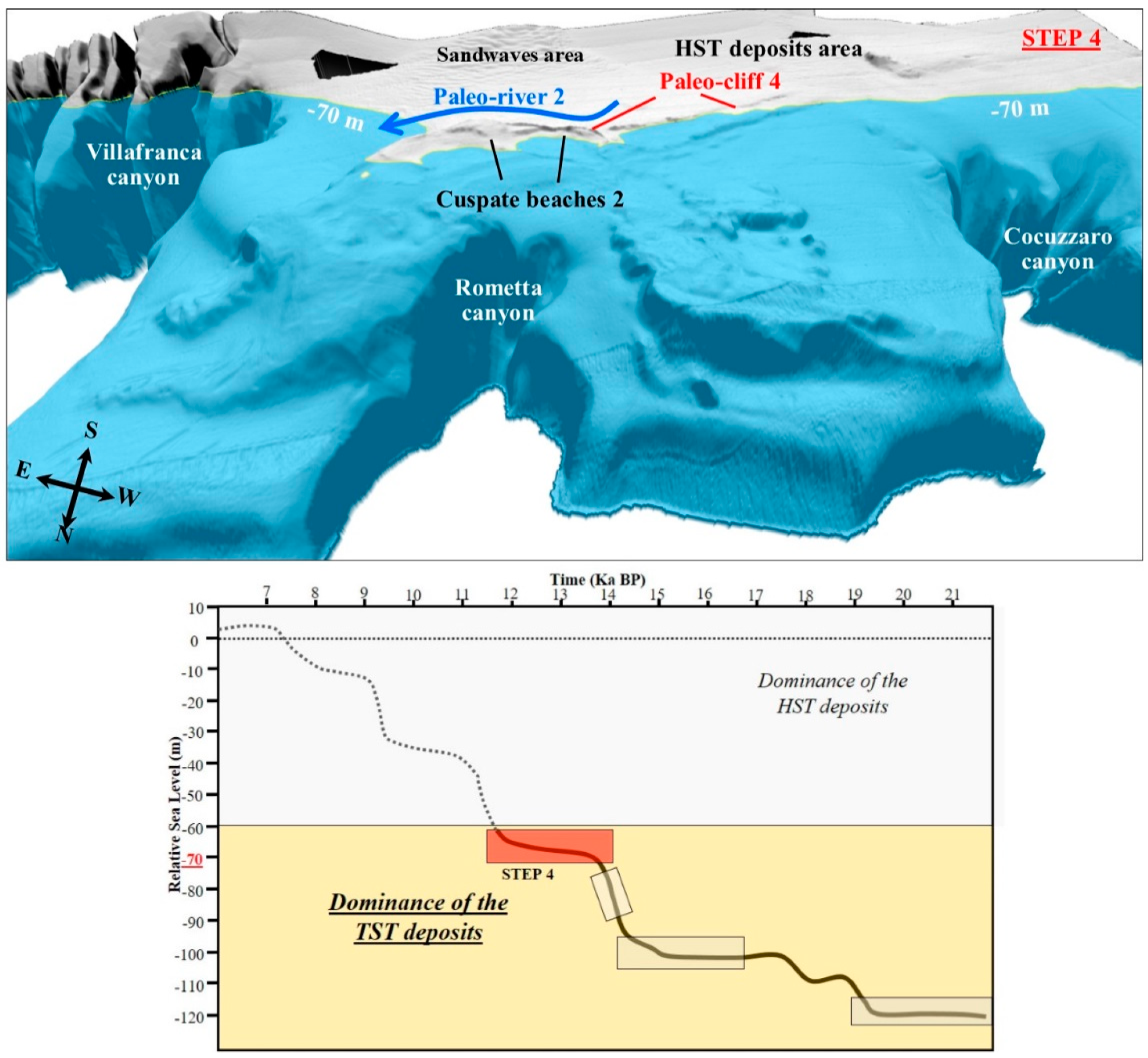
6.1.4. Sea Level −70 m
7. Conclusions
- -
- The lowstand and the falling stage succession corresponds with the foreset of prograding clinoforms of the continental margin. The clinoforms are cut by the erosional surface formed during the last lowstand emersion.
- -
- The L-erosional surface determines the accommodation space for the sediment accumulation during the subsequent rise of the sea level.
- -
- The transgressive deposits are preferentially preserved in the 70–100 m bathymetric range, bounded at the top by the maximum flooding surface and consisting of the relict geomorphic elements that represent past landscapes. These elements track the variations in the coastline position during the last sea-level rise and they have also been reconstructed with the support of 3D bathymetric maps. One of the tracts with a relatively lower rate of rise of seafloor occurred when the sea level rose from about 90 to 70 m below its present-day position. This corresponds with the depth where, in the northeastern Sicilian relict outer shelf, the coastal systems are best developed. Therefore, the transgressive geomorphic elements could have formed during an interval of a relatively reduced rate of sea level rise.
- -
- The highstand wedge consists of the Cocuzzaro and Rometta delta deposits that widely develop on the offshore portions of the inner continental shelf. The bathymetric data image of the deltas starts from a distance of 600 m from the coastline at an average depth of 40 m. The highstand wedge does not reach depths of more than 85 m, leaving the past coastal system cropping out at the seafloor of the outer relict shelf uncovered.
Author Contributions
Funding
Institutional Review Board Statement
Informed Consent Statement
Data Availability Statement
Acknowledgments
Conflicts of Interest
References
- Weimer, P.; Shipp, C. Mass transport complex: Musing on past uses and suggestions for future directions. In Proceeding of the Offshore Technology Conference, Houston, TX, USA, 3 May 2004. [Google Scholar]
- Gamberi, F.; Breda, A.; Mellere, D. Depositional canyon heads at the edge of narrow and tectonically steepened continental shelves: Comparing geomorphic elements, processes and facies in modern and outcrop examples. Mar. Petrol. Geol. 2017, 87, 157–170. [Google Scholar] [CrossRef]
- Gamberi, F.; Dalla Valle, G.; Marani, M.; Mercorella, A.; Distefano, S.; Di Stefano, A. Tectonic controls on sedimentary system along the continental slope of the central and southeastern Tyrrhenian Sea. Ital. J. Geosci. 2019, 138, 317–332. [Google Scholar] [CrossRef]
- Distefano, S.; Gamberi, F.; Baldassini, N.; Di Stefano, A. Late Miocene to Quaternary structural evolution of the Lampedusa Island offshore. Geogr. Fis. Din. Quat. 2018, 41, 17–31. [Google Scholar]
- Distefano, S.; Gamberi, F.; Baldassini, N.; Di Stefano, A. Neogene stratigraphic evolution of a tectonically controlled continental shelf: The example of the Lampedusa Island. Ital. J. Geosci. 2019, 138, 418–431. [Google Scholar] [CrossRef]
- Distefano, S.; Gamberi, F.; Baldassini, N.; Di Stefano, A. Quaternary Evolution of Coastal Plain in Response to Sea-Level Changes: Example from South-East Sicily (Southern Italy). Water 2021, 13, 1524. [Google Scholar] [CrossRef]
- Distefano, S.; Gamberi, F.; Borzì, L.; Di Stefano, A. Quaternary Coastal Landscape Evolution and Sea-Level Rise: An Example from South-East Sicily. Geosciences 2021, 11, 506. [Google Scholar] [CrossRef]
- Borzì, L.; Anfuso, G.; Manno, G.; Distefano, S.; Urso, S.; Chiarella, D.; Di Stefano, A. Shoreline Evolution and Environmental Changes at the NW Area of the Gulf of Gela (Sicily, Italy). Land 2021, 10, 1034. [Google Scholar] [CrossRef]
- Molina, R.; Anfuso, G.; Manno, G.; Gracia Prieto, F.J. The Mediterranean coast of Andalusia (Spain): Medium-term evolution and impacts of coastal structures. Sustainability 2019, 11, 3539. [Google Scholar] [CrossRef] [Green Version]
- Cattaneo, A.; Steel, R.J. Transgressive deposits: A review of their variability. Earth-Sci. Rev. 2003, 62, 187–228. [Google Scholar] [CrossRef]
- Oertel, G.F.; Krafi, J.C.; Kearney, M.S.; Woo, H.J. A Rational Theory for Barrier-Lagoon Development; Society for Sedimentary Geology; Datapages, Inc.: Tulsa, OK, USA, 1992; No. 48. [Google Scholar]
- Swift, D.J.P.; Stanley, D.J.; Curray, J.R. Relict sediments on continental shelves: A reconsideration. J. Geol. 1971, 79, 322–349. [Google Scholar] [CrossRef]
- Wright, L.D.; Short, A.D. Morphodynamic variability of surf zones and beaches: A synthesis. Mar. Geol. 1984, 56, 93–118. [Google Scholar] [CrossRef]
- Hesp, P.A. Conceptual models of the evolution of transgressive dune field systems. Geomorphology 2013, 199, 138–149. [Google Scholar] [CrossRef]
- Picart, A.J.; Hesp, P.A. Spatio-temporal geomorphological and ecological evolution of a transgressive dunefield system, Northern California, USA. Glob. Planet. Chang. 2019, 172, 88–103. [Google Scholar] [CrossRef]
- Firetto Carlino, M.; Di Stefano, A.; Budillon, F. Seismic facies and seabed morphology in a tectonically controlled continental shelf: The Augusta Bay (offshore eastern Sicily, Ionian Sea). Mar. Geol. 2013, 335, 35–51. [Google Scholar]
- Liu, Y.; Huang, H.; Qi, Y.; Liu, X.; Yang, X. Holocene coastal morphologies and shoreline reconstruction for the southwestern coast of the Bohai Sea, China. Quat. Res. 2016, 86, 144–161. [Google Scholar] [CrossRef]
- Hernández-Cordero, A.I.; Pérez-Chacón Espino, E.; Hernández-Calvento, L. Vegetation, distance to the coast, and aeolian geomorphic processes and landforms in a transgressive arid coastal dune system. Phys. Geogr. 2014, 36, 60–83. [Google Scholar] [CrossRef]
- Barberi, F.; Civetta, L.; Gasparini, P.; Innocenti, F.; Scandone, R.; Villari, L. Evolution of a section of the Africa-Europe plate boundary: Paleomagnetic and volcanological evidence from Sicily. Earth Planet. Sci. Lett. 1974, 22, 123–132. [Google Scholar] [CrossRef]
- Patacca, E.; Sartori, R.; Scandone, P. Tyrrhenian basin and Apenninic arcs: Kinematic relations since Late Tortonian times. Mem. Soc. Geol. Ital. 1990, 45, 425–451. [Google Scholar]
- Faccenna, C.; Becker, T.W.; Lucente, F.P.; Jolivet, L.; Rossetti, F. History of subduction and back arc extension in the Central Mediterranean. Geophys. J. Int. 2001, 145, 809–820. [Google Scholar] [CrossRef] [Green Version]
- Barbera, G.; Mazzoleni, P.; Critelli, S.; Pappalardo, A.; Lo Giudice, A.; Cirrincione, R. Provenance of shales and sedimentary history of the Monte Soro Unit, Sicily. Period. Mineral. 2006, 75, 313–330. [Google Scholar]
- Lentini, F.; Vezzani, L. Le unità meso-cenozoiche della copertura sedimentaria del basamento cristallino peloritano (Sicilia nord-orientale). Boll. Soc. Geol. Ital. 1975, 94, 537–554. [Google Scholar]
- Lentini, F.; Carbone, S.; Catalano, S.; Grasso, M. Principali lineamenti strutturali della Sicilia nord-orientale. Studi Geol. Camerti 1995, 2, 319–329. [Google Scholar]
- Monaco, C.; Tortorici, L. Active faulting in the Calabrian arc and eastern Sicily. J. Geodyn. 2000, 29, 407–424. [Google Scholar] [CrossRef]
- Gamberi, F.; Rovere, M.; Mercorella, A.; Leidi, E.; Dalla Valle, G. Geomorphology of the NE Sicily continental shelf controlled by tidal currents, canyon head incision and river-derived sediments. Geomorphology 2014, 217, 106–121. [Google Scholar] [CrossRef]
- Pavano, F.; Catalano, S.; Romagnoli, G.; Tortorici, G. Hypsometry and relief analysis of the southern termination of the Calabrian arc, NE-Sicily (southern Italy). Geomorphology 2018, 304, 74–88. [Google Scholar] [CrossRef]
- Pang, R.; Xu, B.; Zhou, Y.; Song, L. Seismic time-history response and system reliability analysis of slopes considering uncertainty of multi-parameters and earthquake excitations. Comput. Geotech. 2021, 136, 104245. [Google Scholar] [CrossRef]
- Liu, J.P.; Milliman, J.D.; Gao, S.; Cheng, P. Holocene development of the Yellow River’s subaqueous delta, North Yellow Sea. Mar. Geol. 2004, 209, 45–67. [Google Scholar] [CrossRef]


| Seismic Facies | Acoustic Features | Interpretation | |
|---|---|---|---|
| Highstand System Tract |  | Sequence of high amplitude reflectors with good lateral continuity and sub-horizontal trend | Deposits of the river deltas lying along the north-eastern Sicily coastline |
| T-reflector |  | Moderate amplitude reflection and good lateral continuity | Maximum Flooding Surface |
| Transgressive System Tract | 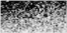 | Sequence of chaotic high amplitude reflectors | Transgressive deposits |
| L-reflector |  | High amplitude reflection and excellent lateral continuity | Subaerial erosional surface |
| Lowstand and Falling Stage System Tract | 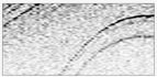 | Moderate-low amplitude reflection with setting from sub-vertical to sub-horizontal and slightly wavy | Foreset of the prograding clinoforms of the northeastern Sicilian continental margin |
Publisher’s Note: MDPI stays neutral with regard to jurisdictional claims in published maps and institutional affiliations. |
© 2022 by the authors. Licensee MDPI, Basel, Switzerland. This article is an open access article distributed under the terms and conditions of the Creative Commons Attribution (CC BY) license (https://creativecommons.org/licenses/by/4.0/).
Share and Cite
Distefano, S.; Gamberi, F. Preservation of Transgressive System Tract Geomorphic Elements during the Holocene Sea Level Rise in the South-Eastern Sicilian Tyrrhenian Margin. J. Mar. Sci. Eng. 2022, 10, 1013. https://doi.org/10.3390/jmse10081013
Distefano S, Gamberi F. Preservation of Transgressive System Tract Geomorphic Elements during the Holocene Sea Level Rise in the South-Eastern Sicilian Tyrrhenian Margin. Journal of Marine Science and Engineering. 2022; 10(8):1013. https://doi.org/10.3390/jmse10081013
Chicago/Turabian StyleDistefano, Salvatore, and Fabiano Gamberi. 2022. "Preservation of Transgressive System Tract Geomorphic Elements during the Holocene Sea Level Rise in the South-Eastern Sicilian Tyrrhenian Margin" Journal of Marine Science and Engineering 10, no. 8: 1013. https://doi.org/10.3390/jmse10081013
APA StyleDistefano, S., & Gamberi, F. (2022). Preservation of Transgressive System Tract Geomorphic Elements during the Holocene Sea Level Rise in the South-Eastern Sicilian Tyrrhenian Margin. Journal of Marine Science and Engineering, 10(8), 1013. https://doi.org/10.3390/jmse10081013